Article

Mapping Coniferous Forest Distribution in a Semi-Arid Area Based on Multi-Classifier Fusion and Google Earth Engine Combining Gaofen-1 and Sentinel-1 Data: A Case Study in Northwestern Liaoning, China

1
Institute of Forest Resource Information Techniques, Chinese Academy of Forestry, Beijing 100091, China
2
College of Forestry, Inner Mongolia Agricultural University, Hohhot 010019, China
3
Key Laboratory of Forestry Remote Sensing and Information System of National Forestry and Grassland Administration, Chinese Academy of Forestry, Beijing 100091, China
4
School of Geomatics, Liaoning Technical University, Fuxin 123000, China
*
Author to whom correspondence should be addressed.
Forests 2024, 15(2), 288; https://doi.org/10.3390/f15020288
Submission received: 30 December 2023 / Revised: 31 January 2024 / Accepted: 31 January 2024 / Published: 2 February 2024

Abstract

:
Information about the distribution of coniferous forests holds significance for enhancing forestry efficiency and making informed policy decisions. Accurately identifying and mapping coniferous forests can expedite the achievement of Sustainable Development Goal (SDG) 15, aimed at managing forests sustainably, combating desertification, halting and reversing land degradation, and halting biodiversity loss. However, traditional methods employed to identify and map coniferous forests are costly and labor-intensive, particularly in dealing with large-scale regions. Consequently, a methodological framework is proposed to identify coniferous forests in northwestern Liaoning, China, in which there are semi-arid and barren environment areas. This framework leverages a multi-classifier fusion algorithm that combines deep learning (U2-Net and Resnet-50) and shallow learning (support vector machines and random forests) methods deployed in the Google Earth Engine. Freely available remote sensing images are integrated from multiple sources, including Gaofen-1 and Sentinel-1, to enhance the accuracy and reliability of the results. The overall accuracy of the coniferous forest identification results reached 97.6%, highlighting the effectiveness of the proposed methodology. Further calculations were conducted to determine the area of coniferous forests in each administrative region of northwestern Liaoning. It was found that the total area of coniferous forests in the study area is about 6013.67 km2, accounting for 9.59% of northwestern Liaoning. The proposed framework has the potential to offer timely and accurate information on coniferous forests and holds promise for informed decision making and the sustainable development of ecological environment.

1. Introduction

Forests provide conditions for the survival of animals and plants [1]. As a wide-spread type of forest, coniferous forests are the largest terrestrial biome on Earth [2] and play an irreplaceable role in improving the ecological environment, including combating desertification, carbon storage, and controlling dust storms and soil erosion [3]. With excellent stress resistance, coniferous forests are well adapted to growth in arid, barren, and cold environments [4]. Due to deforestation, pests and diseases, urbanization, and harvesting, coniferous forests are decreasing around the world. There is an urgent need for coniferous forests to be mapped in a timely and accurate manner so that these data can be used in domains such as natural resource management [5], ecological and hydrological modeling [6], and climate change studies [7,8], which can accelerate progress towards the achievement of SDG 15.
Remote sensing technology has a wide range of applications in forestry due to its outstanding advantages, including large-scale coverage, cost effectiveness, and minor restrictions. Currently, remote sensing data such as multispectral images [9], hyperspectral images [10], synthetic aperture radar (SAR) images [11], and LiDAR (light detection and ranging) [12] are often used to map forest types. However, obtaining the remote sensing data for coniferous forest extraction at a large scale can be a challenge, as it requires access to high-quality and high-resolution data, which can be expensive and difficult to obtain. With a good spatial resolution and revisit time, the Chinese Gaofen-1 has been successfully utilized in various fields [13,14,15], and its data have been publicly available since 2013. It is widely believed that Gaofen-1 can be used for coniferous forest extraction in large semi-arid regions. Unfortunately, this potential has not yet been fully explored, especially when integrated with other remote sensing data. The Sentinel-1 constellation, launched by the European Space Agency (ESA), has characteristics including the capability for imaging in all-weather conditions at any time, high spatial resolution, and free availability, and scholars have tried to use Sentinel-1 images for coniferous forest extraction [16,17]. So far, there have been several studies using Sentinel-1 combined with Gaofen-1 to extract forest parameters [18], which implies the possibility of utilizing the amalgamation of Gaofen-1 and Sentinel-1 for coniferous forest extraction in large semi-arid regions.
Google Earth Engine (GEE) is an excellent cloud-based platform. With computing power and storage provided by millions of servers distributed around the world, GEE can be used for geospatial analysis on a global scale [19]. It is worth noting that there are more than forty years of historical imagery stored in GEE’s public data archive, which is updated and expanded daily. Additionally, many mature algorithms have been integrated into GEE, making it easier for users to process and analyze geospatial data without having to develop algorithms from scratch themselves. Pixel-based shallow learning algorithms, such as random forest (RF), support vector machine (SVM), and classification and regression tree (CART), are often employed in GEE for classification tasks. These approaches pay more attention to detailed information, and classification maps usually contain noise. Google has developed a series of products to cooperate with GEE for deep learning model training, model hosting, and model calling. Some deep learning models have been successfully deployed in GEE to map forest harvesting [20], crop type [21], built-up land [22], and coniferous forest extraction [23]. Generally speaking, the existing shallow learning and deep learning methods perform well for mapping certain land-use and land-cover (LULC) types and perform relatively poorly for others. Multi-classifier fusion (MCF) is a method that integrates different classification maps to achieve better classification results than a single classifier (base classifier). It draws upon the advantages of every single classifier to improve the performance of LULC classification tasks and has been successfully employed in diverse fields [24,25,26]. It shows promise for improving classification accuracy and speed by using deep learning and shallow learning as the base classifiers of MCF deployed in GEE for extracting coniferous forests in large semi-arid regions. Unfortunately, insufficient scholarly inquiry has been conducted within this specific field so far.
Northwestern Liaoning is recognized as a focal region for ecological development in China; it acts as an ecological barrier that protects the North China Plain and the Northeast China Plain from the sand invasion of the Horqin Sandy Land [27]. As a typical semi-arid area in China, it is a harsh ecological environment with little rain, has a shortage of water resources, and displays soil desertification, which seriously restricts social development. To improve environmental conditions, in the 1970s, China implemented afforestation programs to increase forest coverage through artificial planting and aerial seeding afforestation [3], and coniferous forests (Chinese pine, Pinus sylvestris, etc.) were selected as the main tree species for afforestation due to their strong stress resistance. In recent years, the ecosystem in northwestern Liaoning has continued to improve. However, factors such as pests and diseases, the conversion of forests to farmland, and inappropriate management measures have interfered with coniferous forests in recent years, threatening the healthy development of the ecological environment in this area.
To improve the accuracy and efficiency of the forest inventory, a methodological framework is needed to identify coniferous forests in the semi-arid area of northwestern Liaoning, which can provide a baseline for forest management policy development and forest ecosystem conservation. The methodological framework incorporates two machine learning methods with completely different working principles, patch-based deep convolutional neural networks and pixel-based shallow learning methods, and the four maps are merged using a majority voting principle. By integrating deep learning and shallow learning methods, this study aims to overcome the limitations of single classifiers and provide a more accurate and comprehensive understanding of the extent and distribution of coniferous forests. Additionally, employing the combination of optical and radar imagery for land-cover classification offers significant advantages. In this study, multi-source remote sensing images, including those from Chinese Gaofen-1 and ESA Sentinel-1, serve as data sources for coniferous forest identification. This allows the utilization of both the spectral characteristics of Gaofen-1 and the backscattering properties of Sentinel-1 during the identification process. It is worth mentioning that most of these operations can be performed in the GEE cloud computing platform, except for the preprocessing of Gaofen-1 images. This will greatly enhance the efficiency of coniferous forest extraction, especially at large regional and national scales.

2. Study Area and Materials

2.1. Study Area

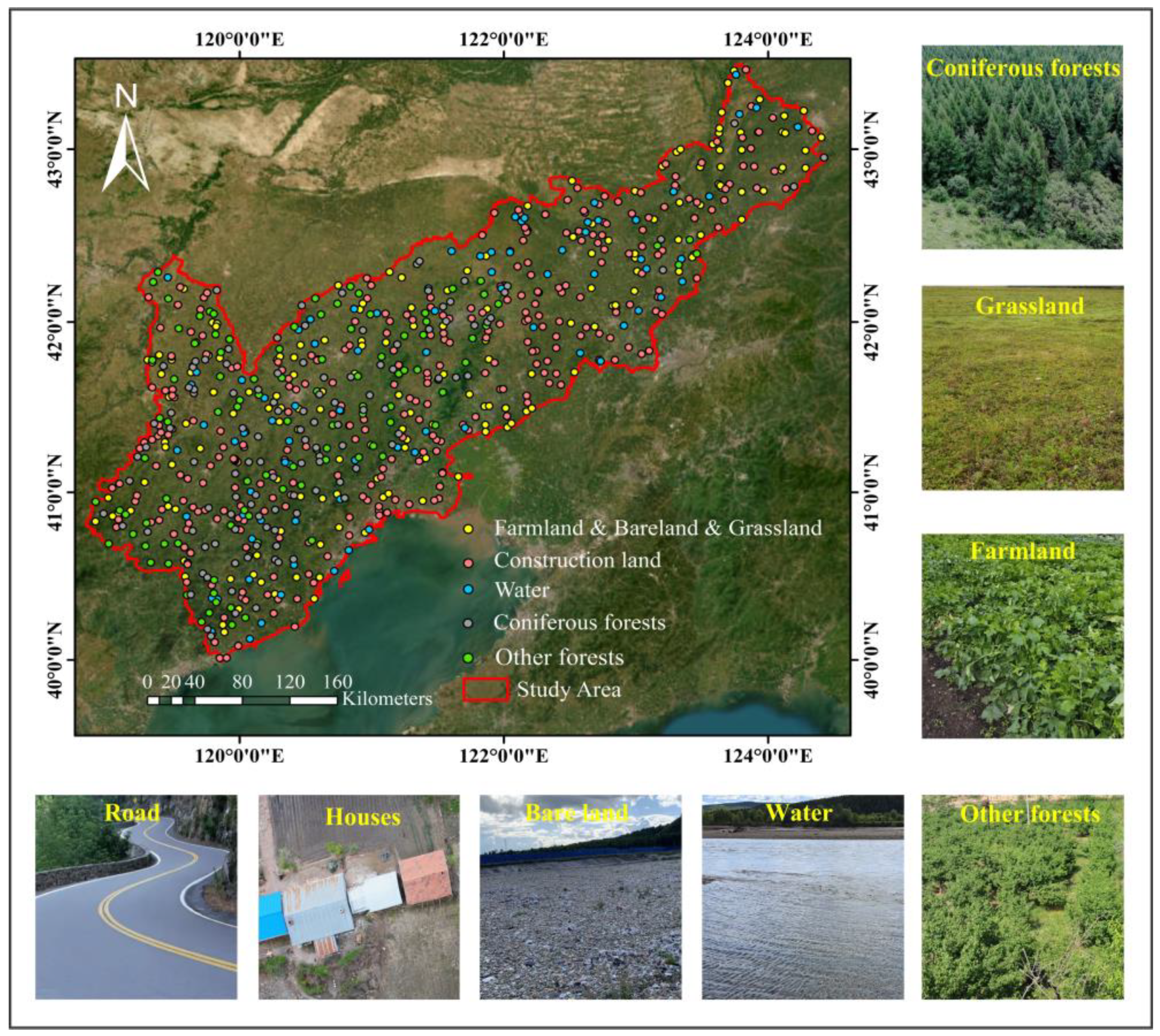
The study area is situated in the northwest of Liaoning Province (northwestern Liaoning), China (see Figure 1), and borders Jilin Province to the east, the Inner Mongolia Autonomous Region to the north, and Hebei Province to the west. Northwestern Liaoning spans approximately 62,885 km2, comprising 42.49% of the total area of Liaoning Province. Its longitude ranges from 118°49′50″ E to 124°25′25″ E and its latitude ranges from 39°59′33″ N to 43°29′18″ N (WGS_1984_UTM_51). It includes the five cities of Chaoyang, Huludao, Fuxin, Jinzhou, and Xinmin, and the three counties of Changtu, Faku, and Kangping. Topographically, northwestern Liaoning is high-lying in the northwest and low-lying in the southeast. This area is mainly dominated by plains and hills, with elevations ranging from −156 to 1245 m. Northwestern Liaoning is located in the mid-latitudes and belongs to the warm temperate semi-humid and semi-arid continental monsoon climate zone, with a climate that is characterized by cold winters and hot summers. The annual average temperature in northwestern Liaoning is 6.4–8.5 °C, and the precipitation is mostly concentrated from June to August [28].
Due to being adjacent to the Horqin Sandy Land, and as it is affected by drought as well as human activities, land desertification in northwestern Liaoning is serious. Thus, a large number of shelterbelts have also been planted in this area to improve the ecological environment. The dominant tree species used in shelterbelts include Chinese pine, Pinus sylvestris, Robinia pseudoacia, poplar, and willow [29,30].

2.2. Remote Sensing Images and Preprocessing

Gaofen-1 and Sentinel-1 were selected as the data sources. It has been proven that coniferous forests have better separability than other LULC types from November to April in a year [23]. Based on this, Gaofen-1 and Sentinel-1 images from 1 November 2019 to 20 April 2020 with cloud cover of less than 20% were chosen for coniferous forest extraction in northwestern Liaoning.
Gaofen-1 is a Chinese Earth observation satellite launched by the China National Space Administration (CNSA) in 2013. With a spatial resolution of 16 m, the multispectral images have four bands, including blue (0.45–0.52 µm), green (0.52–0.59 µm), red (0.63–0.69 µm), and near-infrared (0.77–0.89 µm). Users can obtain Gaofen-1 data from the China Center for Resources Satellite Data and Application (https://data.cresda.cn/#/2dMap, accessed on 16 July 2023). After cloud cover filtering and boundary filtering, 18 Gaofen-1 Level-1A image scenes were obtained. The software packages ENVI 5.3 (Harris Corp., Melbourne, FL, USA) and ArcGIS 10.5 (ESRI, Redlands, CA, USA) were used to preprocess these images, including the following steps: radiometric calibration, atmospheric correction, orthorectification, geometric correction, mosaicking, and cropping. In detail, the Gaofen-1 images were radiometrically calibrated using the absolute radiometric calibration coefficients provided by the China Center for Resources Satellite Data and Application (CRESDA). The atmospheric correction was then conducted employing the FLAASH module in ENVI software to obtain surface reflectance values. The orthorectification was performed by employing rational polynomial coefficient (RPC) files and a digital elevation model (DEM) with a spatial resolution of 30 m. To improve the geometric accuracy, a total of 35 ground control points (GCPs) were collected to perform geometric correction on the Gaofen-1 data. The operations of mosaicking and cropping were subsequently performed in ENVI and ArcGIS, respectively. Finally, the 5.48 GB Gaofen-1 image covering northwestern Liaoning was generated and uploaded to Google Assets.
The Sentinel-1 satellite constellation consists of two satellites, and was launched by the ESA for the purpose of Earth observation. Sentinel-1 can provide all-weather day and night radar images with 10 m spatial resolution and a 5-day revisit time. A total of 299 scenes from the COPERNICUS/S1_GRD image collection in GEE were collected (https://developers.google.com/earth-engine/datasets/catalog/COPERNICUS_S1_GRD, accessed on 16 July 2023) through boundary filtering and date filtering. The SAR images in this dataset are ground range-detected (GRD) scenes, which were preprocessed using the Sentinel-1 Toolbox. The VV (vertical transmit/vertical receiver) and VH (vertical transmit/horizontal receiver) backscatter coefficients were used for coniferous forest extraction, and they were composited and clipped using functions in GEE. The specific information regarding the data source is shown in Table 1.

2.3. Training and Validation Samples

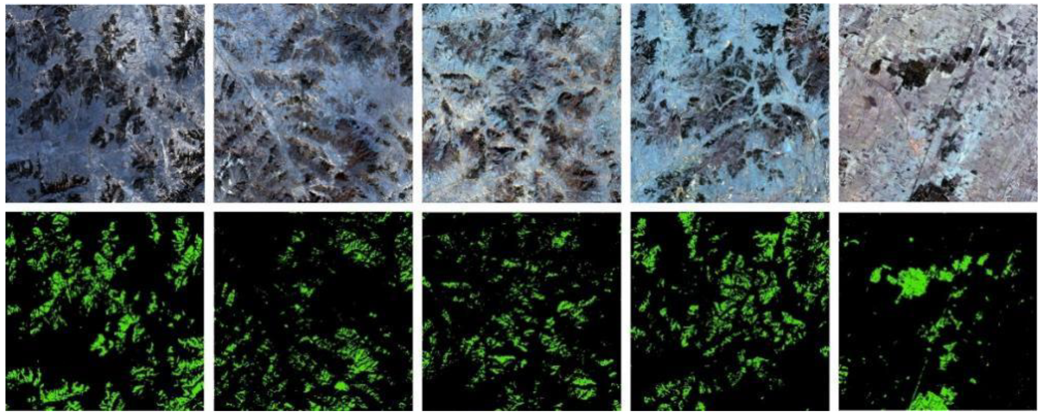
In this paper, the LULC types of the study area are divided into two classes: coniferous forests and non-coniferous forests. Cultivated land, grassland, bare land, water, other forests, and construction land belong to the non-coniferous forest land types. Since the imaging of the selected remote sensing images occurred during winter, cultivated land, grassland, and bare land display a similar spectral reflectance in images. The field survey was conducted in August 2020 and August 2021, and 3104 sample points (see Figure 2) were obtained combined with visual interpretation on Google Earth Pro. These sample points of each class were merged and added to a unique identification field. A random selection was performed where 70% of the sample points were utilized for training purposes, while the remaining 30% were reserved for validation. For block samples used in deep learning methods, 20 subareas sized 18 × 18 km and evenly distributed in the study area were selected. The coniferous forest distribution maps of the 20 subareas were generated using SVM and Sentinel-2 images. To fine-tune the extraction results, ArcGIS software was then employed to remove salt-and-pepper noise and incorrect classification results. The block samples were augmented using cropping, rotation, and flipping. Finally, 640 sample blocks were generated, and then uploaded to Google Assets in Geotiff format. Figure 3 shows some of the block samples, and the specific sample information (point samples and block samples) is shown in Table 2.

3. Methods

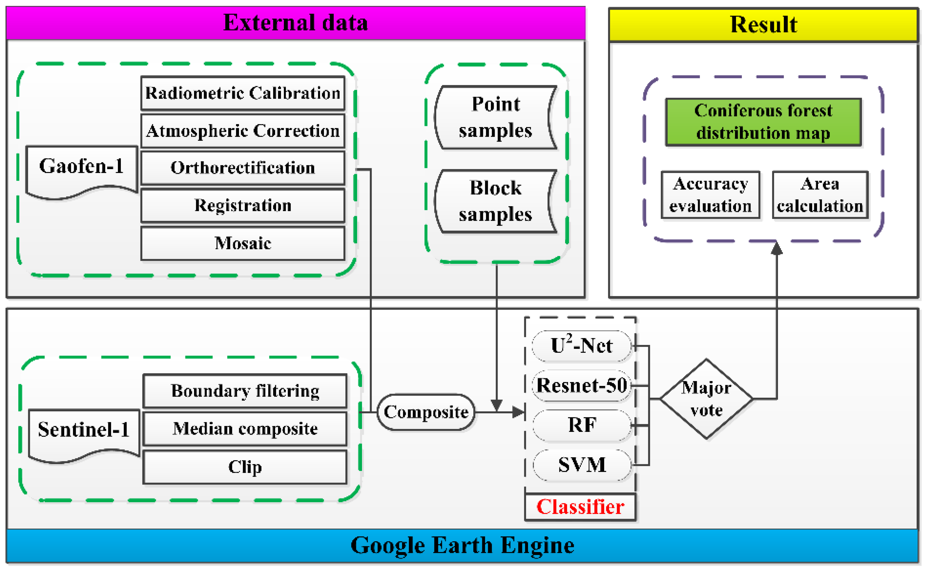
A full program (see Figure 4) was designed to utilize multispectral data (Gaofen-1) and C-band SAR data (Sentinel-1) to map coniferous forests in a large semi-arid region based on the proposed multi-classifier fusion algorithm deployed in GEE, integrating deep learning (U2-Net and Resnet-50) and shallow learning (SVM and RF). Firstly, the downloaded Gaofen-1 images were preprocessed on personal computers, involving the following steps: radiometric calibration, atmospheric correction, orthorectification, geometric registration, mosaicking, and cropping. Then, the preprocessed Gaofen-1 images, the point samples in shapefile format, and the block samples in Geotiff format were uploaded to GEE Assets. Secondly, the Sentinel-1 images covering the study area were collected in GEE through boundary filtering, time filtering, median synthesis, and cropping operations. The final image used for coniferous forests extraction was composed of Sentinel-1 images and Gaofen-1 images, which have six bands (i.e., blue, green, red, NIR, VV, and VH). The proposed multi-classifier fusion algorithm was employed to map the coniferous forest distribution, and the area calculation and accuracy evaluation were conducted. Finally, the driving factors and characteristics of coniferous forest distribution were analyzed in the study area.

3.1. The Base Classifiers

U2-Net is an advanced convolutional neural network (CNN) renowned for its simplicity and effectiveness, primarily due to its unique two-level nested U-structure [31]. Inspired by the U-Net architecture, U2-Net consists of an encoder path comprising six encoder blocks and a decoder path comprising five decoder blocks. In U2-Net, each block, known as the ReSidual U-block, follows a Unet-like structure, which can capture contextual information at various scales in the first four encoder stages. Due to the low resolution of feature maps, the dilated convolution is employed in the last two encoder stages to replace the max-pooling operation. The decoder stages have the same structures as the encoder stages, and they are connected to the symmetrical encoder stages. Six saliency probability maps are generated, which are the same size as the input images. They are then integrated together, and the final coniferous forest probability map is generated through a series of operations, including concatenation and convolution.
As deep neural networks grow in depth with an expanding number of layers, they often encounter the challenge of degradation. To solve this problem, a deep residual learning framework named residual blocks was proposed [32]. ResNet has various architectures (i.e., ResNet-18, 34, 101, 152). Using residual connections, ResNet-50 can effectively train deep networks with improved performance and easier optimization. It has achieved state-of-the-art results in various computer vision tasks, such as image classification, object detection, and semantic segmentation. The architecture of ResNet-50 has been widely adopted and serves as a backbone for many other advanced CNN models.
SVM is often employed to deal with classification and regression analysis tasks in the field of pattern recognition. It can achieve satisfactory performance in processing nonlinear and high-dimensional data. The principle of SVM is to find a decision boundary for separating the samples of different classes. The decision boundary can be a straight line or a plane. Finding a clear-cut line or plane to fully separate the data has been proven to be challenging due to the complexity of the spatial distribution of samples. Thus, the soft margin SVM [33] was proposed, allowing the misclassification of a small number of samples while most samples are correctly classified. To separate samples of different classes more effectively, the radial basis function (RBF), and linear, nonlinear, polynomial, and Gaussian functions, are the most commonly used functions utilized when transforming data from a low-dimensional to a high-dimensional space. The Library for SVM (LibSVM) in GEE was used to extract coniferous forests, and RBF was selected as the kernel function. Through experiments, the two parameters of gamma and cost were finally set as 16 and 34, respectively [34].
As an ensemble learning algorithm in shallow learning, RF is a combination of decision trees [35] and has been widely used in various areas. By applying the technique of bootstrap aggregating (bagging), training samples were randomly selected with the replacement from a training set. Since each decision tree was trained using different samples, the final results usually have strong noise resistance. Additionally, RF has demonstrated strengths in handling high-dimensional data and exhibited robust generalization capabilities. It possesses the unique advantage of eliminating the requirement for manual feature selection. The smileRandomForest function in GEE was used in this study, and the parameter of decision tree number was set to 50 [34].

3.2. Multiple Classifier Fusion

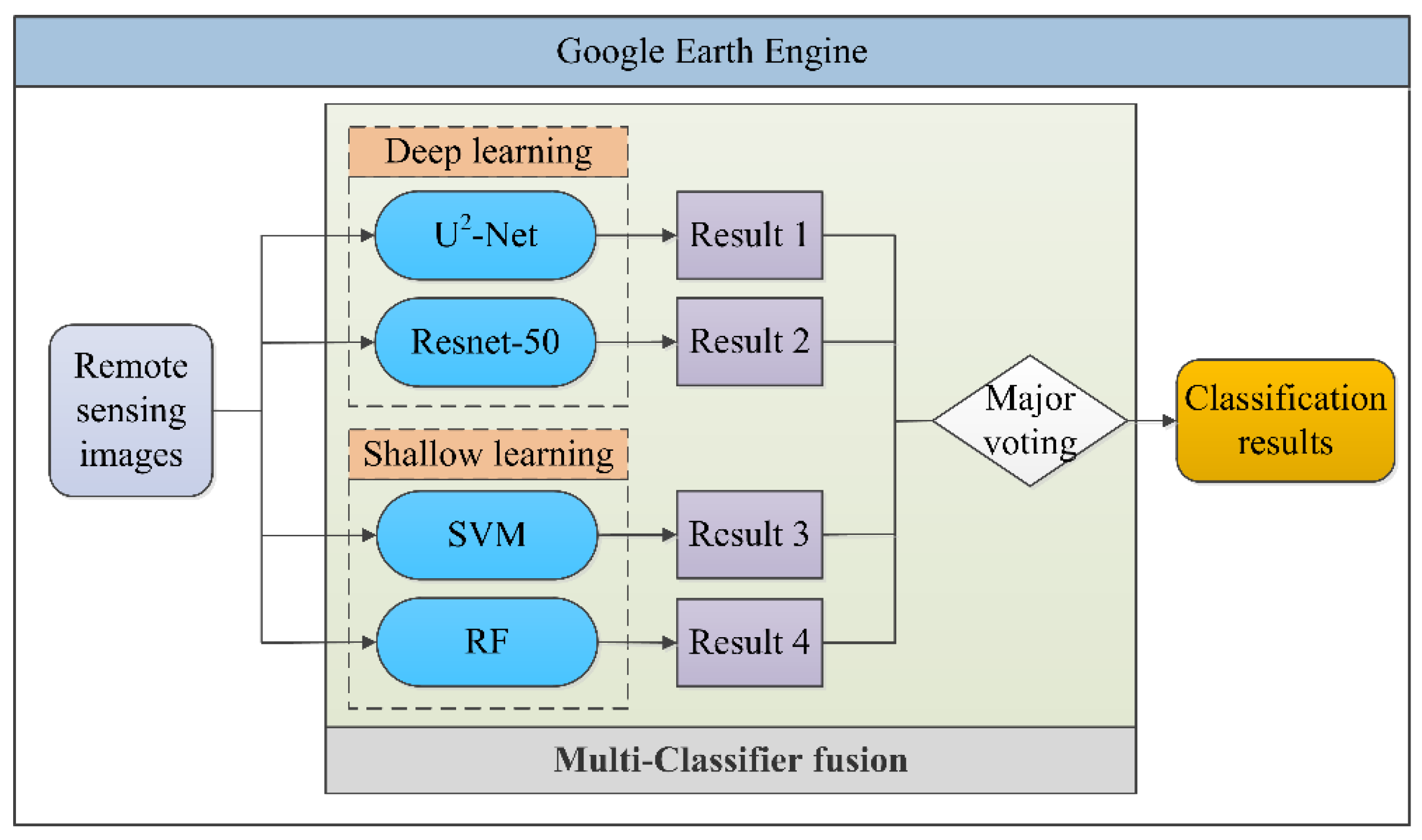
Shallow learning and deep learning techniques were employed in various classification tasks. So far, there is no universal algorithm that is applicable to all classification tasks, which are related to factors such as image type, imaging time, training samples, and algorithm selection. The accuracy, robustness, and applicability of these algorithms still need to be improved. Multi-classifier fusion is a technique that integrates the outputs of multiple base classifiers and can achieve excellent performance in classification tasks. Coniferous forest distribution in northwestern Liaoning is extensive. Shallow learning classifiers based on point samples can obtain more detailed information, while deep learning classifiers based on block samples can identify coniferous forests with high accuracy and minimal salt-and-pepper noise without the need for feature extraction. As shown in Figure 5, four algorithms, namely, two deep learning models (i.e., U2-Net and Resnet-50) and two shallow learning methods (i.e., SVM and RF), were employed to extract coniferous forests. Four binary classification maps were integrated based on the principle of majority voting (Equation (1)).
H ( x ) = c j , i f i = 1 T h i j ( x ) > 0.05 k = 1 N i = 1 T h i k ( x ) r e j e c t , o t h e r w i s e
where cj belongs to the set of land-cover categories {c1, c2, …cN}, T is the number of classifiers, N is the number of categories, hij(x) indicates that the classifier hi divides the pixel x into the category cj, and similarly, hik(x) means that classifier hi classifies pixel x as category ck. Equation (1) indicates that when more than half of the classifiers hi classify x into cj, the final category H(x) = cj is determined, otherwise the category of x is uncertain.

3.3. Accuracy Assessments

To quantitatively assess the effectiveness of the five models (i.e., MCF, U2-Net, Resnet, SVM, and RF), 930 sample points were randomly selected as the validation points from the dataset (see Figure 2). The sample points for validation were blind to the entire training and prediction process. Five widely utilized accuracy assessment metrics, namely, OA, recall, precision, kappa, and F1 score, were computed based on the validation data and the obtained coniferous forest distribution maps. All these metrics were calculated based on the confusion matrix, and the equations are shown in Equations (2)–(6).
OA = T P + T N T P + T N + F P + F N
Recall = T P T P + F N
Precision = T P T P + F P
where TP represents a true positive, FP represents a false positive, TN represents a true negative, and FN represents a false negative.
F 1 _ scor e = 2 × ( Recall + Precision ) ( Recall Precision )
Kappa = p O p e 1 p e
where po is the sum of the number of samples correctly classified for each class divided by the total number of samples, and pe is the sum of the products of the actual and predicted quantities corresponding to all classes divided by the square of the total number of samples.

4. Results and Analysis

4.1. The Separability of Coniferous Forest from Other Land Types in Remote Sensing Images

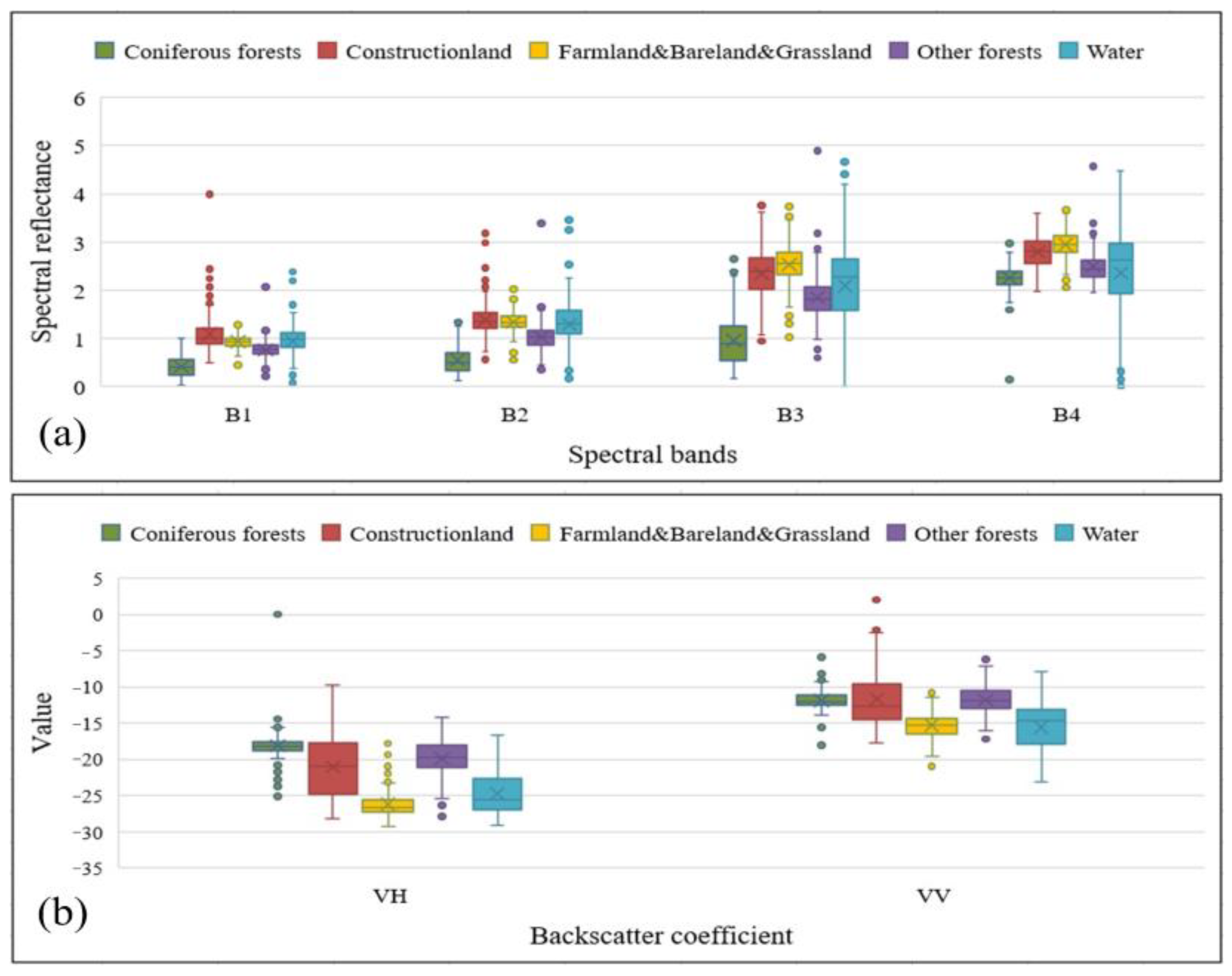
When using remote sensing images for LULC classification, it is imperative to examine the separability of different LULC types based on their spectral reflectance. Generally, the greater the spectral difference between land-cover types, the better their separability. The box plot (see Figure 6) exhibits the spectral reflectance of 798 sample points. These were selected randomly from the point samples shown in Figure 2 and Table 2, including 200 coniferous forest samples; 200 construction land samples; 200 farmland, bare land, and grassland (FBG) samples; 199 other forest samples; and 199 water samples. Figure 6a shows the spectral differences among the five LULC types in Gaofen-1 spectral bands. The spectral differences between coniferous forests and the four other land-cover types are significant. There is a certain difference between the construction land and FBG in band 1 and band 4 of Gaofen-1, but it is not particularly obvious. In band 1 and band 2, the spectral reflectance of FBG and other forests is similar but their differences increase in band 3 and band 4. In all bands of Gaofen-1, the spectral reflectance of water and other forests is relatively similar. Figure 6b shows the backscatter coefficients (VV and VH) of the five LULC types in Sentinel-1. It can be seen that FBG, water, and other forests have more obvious separability in the VV and VH of Sentinel-1 compared to the spectral reflectance in Gaofen-1. Therefore, the combined use of Gaofen-1 and Sentinel-1 is considered to improve the accuracy of coniferous forest extraction compared to the utilization of either of them alone.

4.2. The Performance of Different Classifiers in Coniferous Forest Extraction

To qualitatively and quantitatively assess MFC’s performance in GEE, five metrics were calculated, namely, F1 score, precision, recall, OA, and kappa, based on Equations (1)–(5). As shown in Table 3, of the four basic classifiers (i.e., U2-Net, Resnet-50, SVM, RF), U2-Net performs the best, with F1 score, precision, recall, OA, and kappa reaching 97.1%, 96.3%, 98%, 97.6%, and 0.96%, respectively, which aligns with previous findings [23]. U2-Net outperforms Resnet-50 by 1.1%, 1.8%, 0.4%, 0.7%, and 1.6% in terms of F1 score, precision, recall, OA, and kappa, respectively. Among the shallow learning methods, SVM performs best, with F1 score, precision, recall, OA, and kappa achieving 95.6%, 92.8%, 98.5%, 96.9%, and 0.93, respectively, which are 5.5%, 8.3%, 2.0%, 3.6%, and 8.2% higher than those of RF. Overall, deep learning methods have better performances than shallow learning methods. Specifically, U2-Net outperforms SVM by 1.5%, 3.5%, −0.5%, 0.7%, and 2.8% in terms of F1 score, precision, recall, OA, and kappa, respectively. MCF improves accuracy significantly compared to the other classifiers, with F1 score, precision, recall, OA, and kappa reaching 98.1%, 97.9%, 98.3%, 98.6%, and 0.97, respectively. Compared to U2-Net, the five metrics of MCF increased by 1.0%, 1.6%, 0.3%, 1.0%, and 1.0%, respectively. The five metrics of MCF are 8.0%, 13.4%, 1.8%, 5.3%, and 12% higher than RF. Due to the different principles of these base classifiers, the MCF method comprehensively utilizes the advantages of deep learning and shallow learning as complements to each other, and ultimately improves the accuracy of coniferous forest extraction.
As shown in Figure 7, five subareas (see Figure 7a–e) evenly distributed in northwestern Liaoning were selected to exhibit the extraction results in detail. These subareas are situated in the north, south, west, central, and northeast of northwestern Liaoning, and are each characterized by varying densities of coniferous forests. The first row (see Figure 7a–a5) shows natural forests, the second row (see Figure 7b–b5) shows planted forests, and the third to fifth rows show mixed forests (natural and planted forests). It can be seen from Figure 7a1–e1 and Figure 7a2–e2 that U2-Net and Resnet-50 achieve good performance in coniferous forest extraction in highly homogeneous areas. For the scattered coniferous forests, these two deep learning methods cannot completely separate the fine coniferous forests from the background. It can be seen from Figure 7a3–e3 and Figure 7a4–e4 that the extraction results of SVM and RF contain a lot of fragments, including scattered coniferous forests and salt-and-pepper noise. The coniferous forest extraction results generated by SVM and RF are significantly inferior to those of deep learning methods. However, SVM and RF can extract scattered coniferous forests with higher precision. MCF has advantages of both deep learning and shallow learning, which can not only extract coniferous forests in highly homogeneous areas with clear boundaries and less salt-and-pepper noise but can also clearly express detailed information.

4.3. The Performance of Coniferous Forest Extraction Using Different Data Sources

Employing Gaofen-1 in combination with Sentinel-1 can achieve coniferous forest identification results with higher precision than using either alone, which was demonstrated by analyzing the spectral reflectance of the Gaofen-1 and the backscatter coefficients of Sentinel-1 in Section 4.1. To further verify the feasibility of combining Gaofen-1 and Sentine-1 for coniferous forest extraction, Gaofen-1 was first used alone to conduct the coniferous forest extraction experiment, and then Gaofen-1 and Sentinel-1 were employed together to extract coniferous forests. Both of the extraction tasks were based on the MCF classifier in GEE. As shown in Table 4, the F1 score, precision, recall, OA, and kappa using Gaofen-1 alone are 97.2%, 96.6%, 97.6%, 97.5%, and 0.962, respectively. When the backscatter coefficients of Sentinel-1 were integrated with Gaofen-1, the five metrics of F1 score, precision, recall, OA, and kappa increased by 0.9%, 1.3%, 0.7%, 1.1%, and 0.8%, respectively.
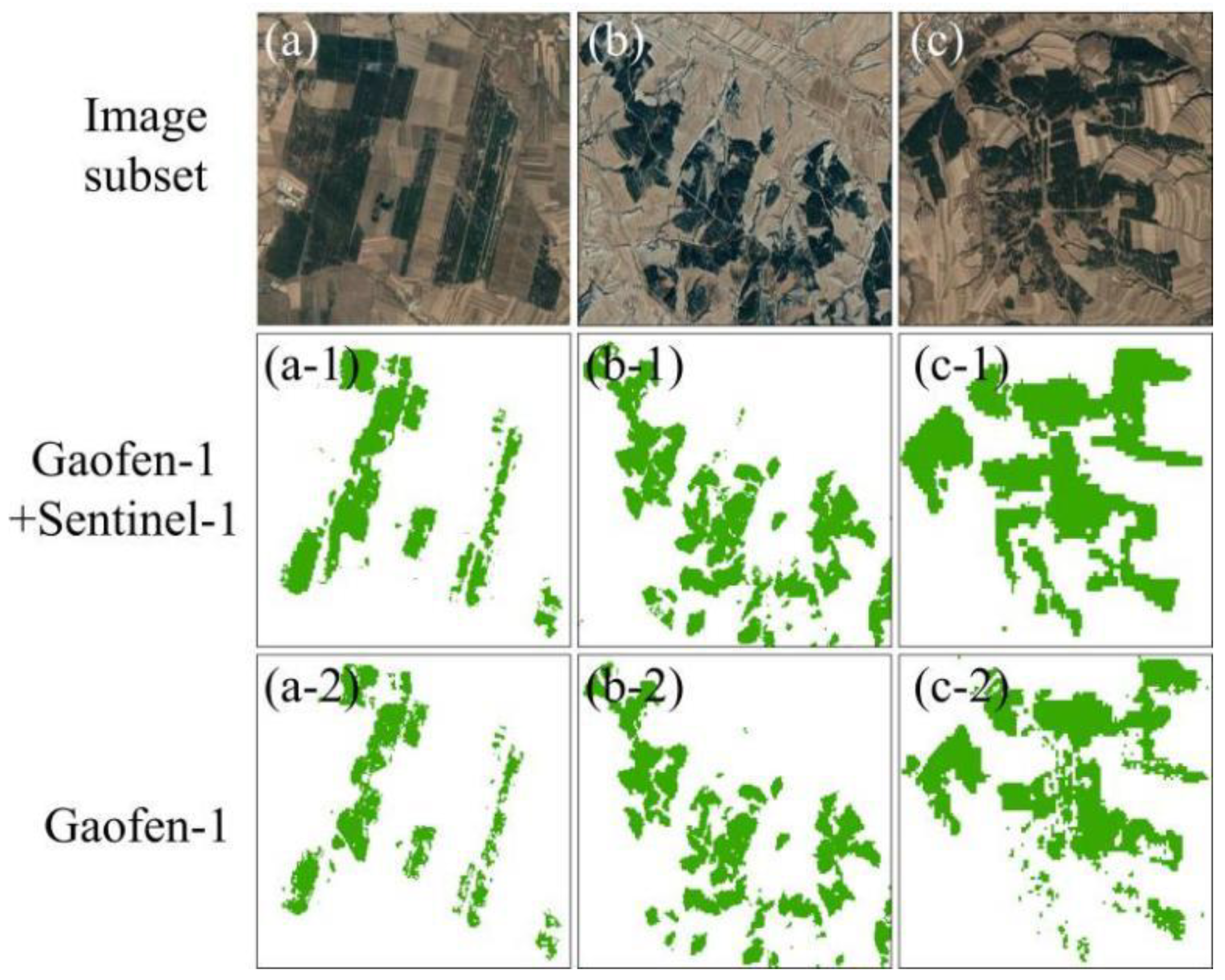
Qualitatively, three subareas were chosen to exhibit the coniferous forest extraction outcomes (see Figure 8). We can see that in the extraction outcomes of planted forests (see Figure 8a,a1,a2), there are many broken patches when Gaofen-1 is employed alone. After combining Sentinel-1 with Gaofen-1, the extraction results were improved and became more complete. In the extraction results of natural forests (see Figure 8b,b1,b2), using Gaofen-1 alone was not able to completely extract the coniferous forests. After combining Gaofen-1 with Sentinel-1, the completeness and accuracy of coniferous forest extraction was improved, especially for the scattered coniferous forests. In the mixed forests of planted and natural forests (see Figure 8c,c1,c2), using Gaofen-1 alone was not effective, and there was obvious salt-and-pepper noise. However, when Gaofen-1 was used in combination with Sentinel-1 to participate in the extraction process, the results were more continuous with clear boundaries.
Since the backscatter coefficients of Sentinel-1 can provide valuable insights into the structure and biomass of coniferous forests, they can help to improve the separability of coniferous forests from other LULC types and enhance the accuracy of coniferous forest extraction.

4.4. Comparison with Other Datasets

At present, there are several land-cover products available, including GlobeLand-30 [36], EAS-Worldcover [37], FROM-GLC [38], CLCD [39], ESRI-10m [40], and MCD12Q1 [41], but few of them include the classification of coniferous forests. GLC_FCS30 [42] (available online: https://data.casearth.cn/), which is one of the few products with the classification of coniferous forests, was selected for comparison with the coniferous forest distribution map generated in this study. The spatial resolution of GLC_FCS30 is 30 m. It includes 16 LULC types, and the OA and kappa are 71.40% and 0.686, respectively.
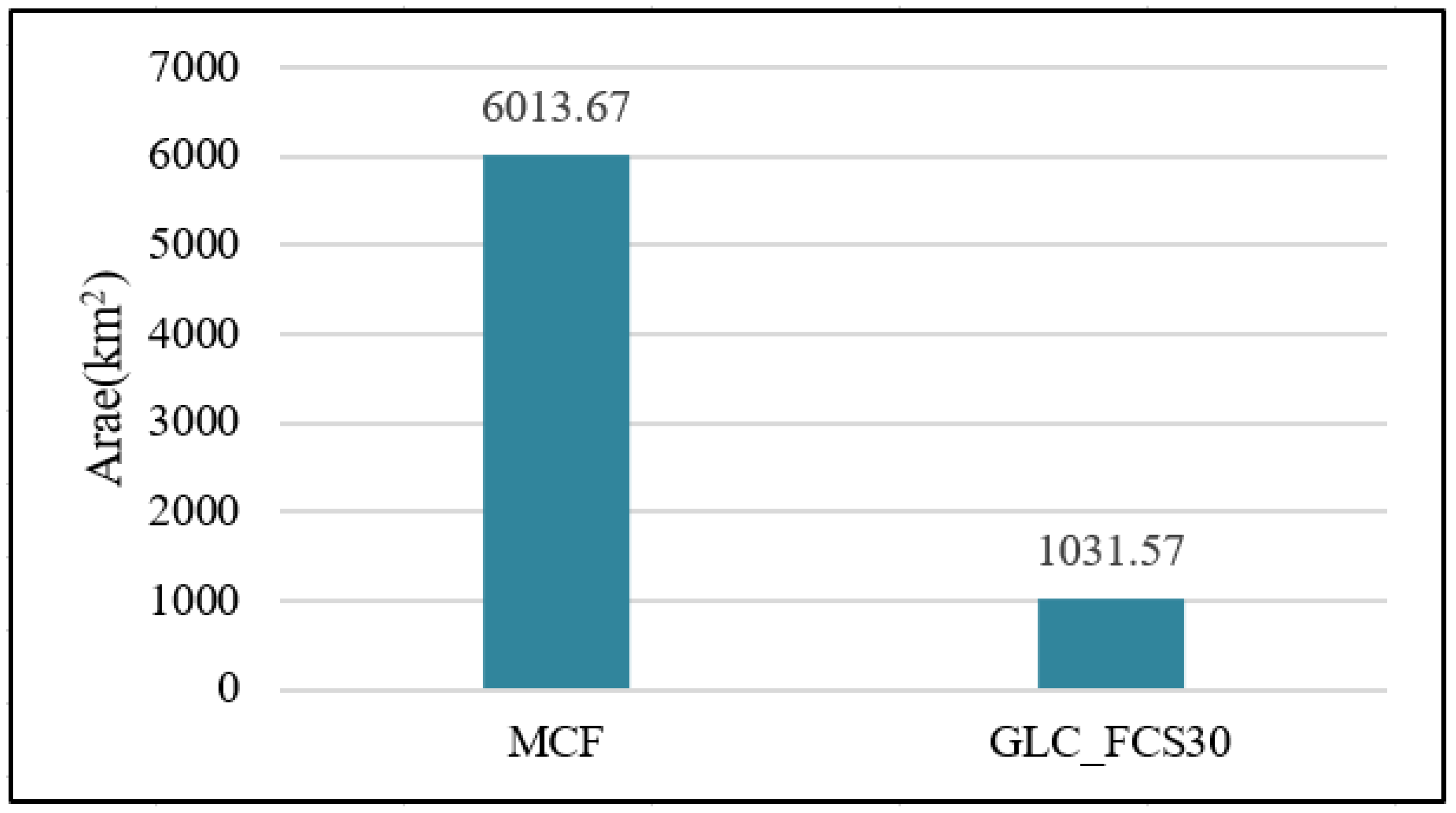
Five subareas are evenly distributed across the study area, in which both natural coniferous forests and artificial coniferous forests can be found (see Figure 9a–e). The coniferous forests identified through the methodological framework described in this article closely align with the actual situation and are complete with clear boundaries (see Figure 9a1–e1). As a global land-cover product, GLC_FCS30 cannot extract all coniferous forests, and the extraction results are fragmented (see Figure 9a2–e2). There may be various reasons for this. First of all, GLC_FCS30 made use of the two-year composite remote sensing data from Landsat-8 OLI, which do not take into account the spectral differences between tree species in different seasons. Experiments have shown that it is not easy to distinguish coniferous forests from other tree species in remote sensing images, except in winter. [23]. Secondly, the spatial resolution of Landsat employed in GLC_FCS30 is 30 m, which is coarser than that of Gaofen-1 (16 m) and Sentinel-1 (10 m) and can have a negative influence on the extraction of coniferous forests. Additionally, only the multispectral bands were used in GLC_FCS30, making the extraction results very sensitive to weather. In this article, a substantial number of samples were collected using a combination of field surveys and visual interpretation, and the training data for GLC_FCS30 were sourced from GSPECLib (Global Spatiotemporal Spectral Library). It should be noted that there are variations in the level of accuracy. As depicted in Figure 10, the area of statistical coniferous forests derived from GLC_FCS30 is only 1031.57 km2, which is significantly smaller than that of MCF (6013.67 km2).

4.5. The Statistics on Coniferous Forest Area in Northwestern Liaoning

In northwestern Liaoning, there are five cities and three counties. It can be observed from Figure 11 that the distribution of coniferous forests varies across these eight administrative regions, exhibiting distinct geographical characteristics. Table 5 provides detailed information about the coniferous forest area. Of the eight regions, Chaoyang has the largest area of coniferous forests and the highest proportion of coniferous forests in relation to its administrative area, which indicates that Chaoyang has effectively implemented the Chinese government’s policies on forest conservation and restoration, making it suitable for the growth of coniferous forests. Huludao, Fuxin, and Jinzhou rank second to fourth in terms of the proportion of coniferous forests within their administrative areas. Xinmin, Faku, Kangping, and Changtu have relatively smaller areas of coniferous forests, with Xinmin containing the lowest proportion, accounting for only 0.48% of its administrative area, despite not having the smallest administrative area. Among these regions, the ranking of coniferous forest areas from largest to smallest is as follows: Chaoyang > Huludao > Fuxin > Jinzhou > Changtu > Faku > Kangping > Xinmin. According to statistics, the total area of northwestern Liaoning is about 62,701.71 km2, with a coniferous forest area of 6013.67 km2, accounting for nearly 10% of the administrative area.

5. Discussion

5.1. Implications of Mapping Coniferous Forests in Northwestern Liaoning

Northwestern Liaoning is a typical semi-arid area in China, and is adjacent to the Horqin Sandy Land in Inner Mongolia. It experiences frequent windy and sandy weather, limited rainfall, and infertile soil, which severely restrict local socio-economic development. Coniferous forests (e.g., Chinese pine and Pinus sylvestris) exhibit good adaptability to the arid environment of northwestern Liaoning. They serve as natural barriers for the Northeast and North China Plain, playing a positive role in improving agricultural productivity, addressing hunger, climate change adaptation, biodiversity conservation, and ecosystem protection, which are all aligned with the United Nations’ SDGs. However, factors such as pests and diseases, wildfires, and unsustainable timber harvesting, along with an imbalanced forest structure, have led to the degradation of coniferous forests in this region. Knowledge of the extent and distribution of these coniferous forests is crucial for sustainable forest management and informed decision making.
Most existing studies have primarily focused on forest extraction [43,44,45], with limited research on the fine-scale identification of coniferous forests. However, the significance of coniferous forests in the semi-arid region of northwestern Liaoning cannot be overlooked, and our current knowledge about them remains limited. Traditional methods relying on manual surveys are costly, laborious, and dangerous and often involve inaccessible areas. Identifying coniferous forests in large-scale areas requires a large number of remote sensing images and reliable identification algorithms, which creates challenges for personal computers with limited computing power and storage space. In this study, a multi-classifier fusion approach combined with multi-source remote sensing imagery was employed for coniferous forest extraction using the GEE platform, achieving satisfactory results and confirming the feasibility of the proposed method.
Most of the coniferous forests in northwestern Liaoning are distributed in the southwestern region, while they are relatively scarce in the northeastern region. Factors such as topography, population, and hydrothermal conditions can affect the distribution of coniferous forests in this region [46,47]. As an indispensable segment of the Three-North Shelter Forest Program [48], northwestern Liaoning contains a considerable portion of artificially planted coniferous forests, which are heavily influenced by human activities. In the plains, most of the land is used for human settlements and agriculture, resulting in a lower distribution of coniferous forests. This phenomenon is particularly evident in the northeastern part of Fuxin, Xinmin, Kangping, Changtu, and Faku. The southwestern part is characterized by mountains and hills, with abundant sunlight, dryness, and a cold climate, which are highly suitable for the growth of coniferous forests. In addition, due to the constraints of the terrain, these areas experience limited human activities, resulting in less encroachment on the growth space of coniferous forests by humans. Therefore, compared to the northeastern part of the study area, there is a relatively higher distribution of coniferous forests in the southwestern part of the study area.

5.2. The Performance of the Proposed Methodological Framework

The proposed methodological framework employing multi-source remote sensing images and multi-classifier fusion achieved high performance (OA = 97.6%) in coniferous forest extraction.
It is not surprising that the methodology combining shallow learning and deep learning achieves such good results in coniferous forest identification. The SVM and RF algorithm belonging to shallow learning have been widely used in various pattern recognition fields [49] since their inception. Benefiting from the rigorous mathematical models, pixel-based shallow learning can effectively obtain information in detail (with the drawback of generating salt-and-pepper noise), resulting in limited identification accuracy in complex scenes [50]. Deep learning, on the other hand, differs fundamentally from traditional machine learning methods in terms of principles. It is a model that mimics the structure and functionality of biological neural networks and is capable of automatically learning higher-level features [51]. The combination of deep learning and shallow learning achieves higher performance compared to the use of a single classifier in coniferous forest extraction.
In recent years, the technology of Chinese remote sensing satellites has developed rapidly. As a medium-resolution satellite, Gaofen-1 was launched in 2013, and its data have been freely available since 2019. Scholars used Gaofen-1 and Sentinel-1 data to conduct research in various fields [52,53]. However, it was unknown whether the performance of Gaofen-1 and Sentinel-1 was appropriate for coniferous forest identification. Therefore, we employed Gaofen-1 combined with Sentinel-1 to extract coniferous forests in northwestern Liaoning. In addition, compared with the revisit time of Sentinel-2 (5 days), Gaofen-1 has a shorter revisit time of 4 days. The width of a Gaofen-1 image is 800 × 800 km, while that of a Sentinel-2 image is 290 × 290 km. Therefore, it can be seen that Gaofen-1 images have their own advantages and cannot be completely replaced by Sentinel-2. As far as we know, this is the first time that the combination of Gaofen-1 and Sentinel-1 data was used to identify coniferous forests in a large-scale area. It was found that coniferous forests are clearly distinguishable in the four spectral bands of Gaofen-1 and the two backscattering coefficients of Sentinel-1 (see Figure 6). As an optical remote sensing satellite, Gaofen-1 is sensitive to spectral information; thus, its imaging process is easily affected by clouds and weather. Radar can obtain images at day and night, regardless of cloud cover and weather [54]. When Sentinel-1 data are integrated with Gaofen-1 data, the recognition of coniferous forests significantly improved compared to using Gaofen-1 alone, with the overall accuracy and kappa increasing by 1.1% and 0.8%, respectively. From a visual perspective, the recognition of coniferous forests appears more comprehensive, indicating the feasibility of utilizing Gaofen-1 and Sentinel-1 data in combination for extracting coniferous forests in northwestern Liaoning.
The size of the administrative area of northwestern Liaoning is about 62,885 km2, accounting for nearly half of the total area of Liaoning Province. Dozens to hundreds of high-quality remote sensing images covering the study area are required to realize the coniferous forests extraction task. Traditional methods of downloading and manually preprocessing remote sensing imagery are time-consuming and computationally demanding, and are limited by the performance of personal computers. GEE is characterized by its computational capabilities and vast amounts of data. On the GEE platform, we utilized deep learning and shallow learning classifiers to identify coniferous forests in northwestern Liaoning using a combination of Gaofen-1 and Sentinel-1 data. These tasks can be unimaginably burdensome for personal computing devices but can be easily accomplished with GEE. The only time-consuming tasks are training the deep learning model, collecting samples for training, and downloading and preprocessing Gaofen-1 images, as Gaofen-1 imagery has not yet been included in the GEE database.

5.3. The Generality of the Proposed Methodological Framework

The forest structure in the study area consists of coniferous and broadleaf forests. In winter, the broadleaf forests in the study area lose their leaves, while coniferous forests appear dark green. Based on this phenomenon, we analyzed the spectral separability of coniferous forests from other land-cover types, including broadleaf forests. It can be seen in Figure 2 [23] that the spectral curves of coniferous forests from February to April and November to January are significantly different from those of other objects. Therefore, we are able to identify coniferous forests accurately from November to April in remote sensing images.
Liu et al. (2022) [9] employed three machine learning methods (i.e., DNN, SVM, and RF) and three datasets (i.e., Sentinel-2, Gaofen-1, and Landsat-8 OLI) to extract coniferous forests in Karaqin Banner of Inner Mongolia, China. The results show that as the spatial resolution of images increases, the extraction accuracy of coniferous forests also increases. When adding spectral indexes to these remote sensing images, the extraction accuracy of coniferous forests using DNN and Sentinel-2 is the highest at 94.4%, and that using RF combined with Landsat-8 OLI is the lowest at 84.8%. Additionally, Liu et al. (2023) [23] utilized a deep learning algorithm (U2-Net) and Landsat series remote sensing images (Landsat-5 TM, Landsat-7 ETM+, and Landsat-8 OLI) to extract coniferous forests in northwestern Liaoning from 1985 to 2020. The results show that U2-Net has good temporal transferability and a better performance than shallow learning algorithms (SVM and RF). In this paper, we employed deep learning algorithms (U2-Net and Resnet-50) combined with shallow learning algorithms (such as SVM and RF) as the classifier, which is a method known as MCF, and the results show that the extraction accuracy of coniferous forests can be further improved compared to any of the classifiers used individually (i.e., U2-Net, Resnet-50, SVM, and RF).
In summary, MCF performs better than deep learning and shallow learning algorithms alone in the process of coniferous forest extraction. Therefore, we believe that the MCF proposed in this paper has the same temporal transferability as deep learning and can be used for other datasets, as shallow learning algorithms can. It can be seen that the method proposed in this paper has good repeatability and transferability, and we will conduct further verification in future research.

5.4. Limitations and Future Work

Gaofen-1 imagery has been freely available since 2019 with good spatial resolution and revisit time [9]. Experimental results have demonstrated that the combination of Gaofen-1 and Sentinel-1 yields satisfactory results in the identification of coniferous forests. Unfortunately, Gaofen-1 data have not yet been included in the GEE database. Currently, we can only preprocess Gaofen-1 images by utilizing professional software such as ENVI offline, which we then upload to GEE Assets—a process that is time-consuming and laborious. Additionally, the distribution of coniferous forests is affected by both natural and socio-economic factors. However, the main driving factors affecting the distribution of coniferous forests and the distribution characteristics of coniferous forests remain unknown, making it difficult to formulate forest management plans and make informed decisions. As a cloud computing platform made in China, PIE-Engine [55] will be employed for coniferous forest extraction in the future as it has collected a vast number of Gaofen-1 images. Driving factor analysis will be conducted to identify which factors have a significant influence on the distribution of coniferous forests. To gain insights into the distribution characteristics of coniferous forests, a statistical analysis will be employed, which can provide baseline data for decision making and ensure the efficiency of forestry. Furthermore, the majority voting strategy used in MCF can be replaced by the D-S evidence theory [56] to further improve the extraction results of coniferous forests.

6. Conclusions

Forests play a vital role in global sustainable development, impacting both the natural environment and economic prosperity. Coniferous forests are an important forest type, known for their excellent ability to thrive in arid and barren environments, and they are widely distributed in northwestern Liaoning. Identifying coniferous forests in a timely and accurate manner is crucial to government decision-making and the formulation of forest management strategies. In this paper, a cloud-based multi-classifier fusion algorithm was proposed to identify coniferous forests in northwestern Liaoning, making use of both deep learning (U2-Net and Resnet-50) and shallow learning (SVM and RF). The F1 score, precision, recall, OA, and kappa values were 98.1%, 97.9%, 98.3%, 98.6%, and 0.97, respectively, outperforming any of these classifiers used alone. Multi-source remote sensing images were utilized in the identification process, combining Gaofen-1 and Sentinel-1 data. The results revealed that incorporating Sentinel-1 data improved identification performance compared to using Gaofen-1 alone, with an overall accuracy increase of 1.1%. In summary, the methodological framework proposed in this paper can quickly and accurately extract coniferous forests in the area of northwestern Liaoning, an area with a semi-arid environment. This provides baseline data for government decision making, reasonable forest management policy formulation, and the acceleration of the realization of the United Nations’ Sustainable Development Goals.

Author Contributions

L.L.: conceptualization, methodology, software, writing—original draft, funding acquisition. Y.G.: data curation, visualization, investigation, methodology, software, funding acquisition. Q.Z. and Z.L.: supervision, project administration. Y.L. and E.C.: writing—review and editing, project administration, methodology. B.W. and S.H.: data curation, visualization, investigation. All authors have read and agreed to the published version of the manuscript.

Funding

This research was funded by the Special Funds for Basic Research Operating Costs of Central Public Welfare Research Institutes “Research on Tree Species Type Classification Methods with Differentiated Characteristics of Multiple Optical Sensors” (project number CAFYBB2022SY030); the 2023 Inner Mongolia Autonomous Region Doctoral Scientific Research Innovation Project (project number B20231092Z); the National Science and Technology Major Project of China’s High-Resolution Earth Observation System (project number 21-Y20B01-9001-19/22); the Science and Technology Plan Project of Inner Mongolia, China (Forest Ecosystem National Observation and Research Station of Greater Khingan Mountains in Inner Mongolia); and the National Science Foundation of China (project number 32260389).

Data Availability Statement

The data presented in this study are available on request from the corresponding author. The data are not publicly available due to privacy or ethical restrictions.

Acknowledgments

We thank Yaqiu Zhang, Shuhan Jia, and Xiaojun He from Liaoning Technical University for their help in data processing. The authors are also grateful to the editors and referees for their constructive criticism of this paper.

Conflicts of Interest

The authors declare no conflicts of interest.

References

  1. Bonan, G.B. Forests and climate change: Forcings, feedbacks, and the climate benefits of forests. Science 2008, 320, 1444–1449. [Google Scholar] [CrossRef]
  2. Buma, B.; Hayes, K.; Weiss, S.; Lucash, M. Short interval fires increasing in the boreal forest as fire self-regulation decays, especially in drier coniferous forest landscapes. Sci. Rep. 2022, 12, 10322935. [Google Scholar] [CrossRef] [PubMed]
  3. Zhai, J.; Wang, L.; Liu, Y.; Wang, C.; Mao, X. Assessing the effects of china’s three-north shelter forest program over 40 years. Sci. Total Environ. 2023, 857, 159354. [Google Scholar] [CrossRef] [PubMed]
  4. Li, B. The alpine timberline of Tibet. In Forest Development in Cold Climates; Springer: Berlin/Heidelberg, Germany, 1993; pp. 511–527. [Google Scholar] [CrossRef]
  5. Abella, S.R.; Springer, J.D. Effects of tree cutting and fire on understory vegetation in mixed conifer forests. For. Ecol. Manag. 2015, 335, 281–299. [Google Scholar] [CrossRef]
  6. Goeking, S.A.; Tarboton, D.G. Forests and water yield: A synthesis of disturbance effects on streamflow and snowpack in western coniferous forests. J. For. 2020, 118, 172–192. [Google Scholar] [CrossRef]
  7. Cassell, B.A.; Scheller, R.M.; Lucash, M.S.; Hurteau, M.D.; Loudermilk, E.L. Widespread severe wildfires under climate change lead to increased forest homogeneity in dry mixed-conifer forests. Ecosphere 2019, 10, e02934. [Google Scholar] [CrossRef]
  8. Furnas, B.J. Rapid and varied responses of songbirds to climate change in california coniferous forests. Biol. Conserv. 2020, 241, 108347. [Google Scholar] [CrossRef]
  9. Liu, L.; Guo, Y.; Li, Y.; Zhang, Q.; Li, Z.; Chen, E.; Yang, L.; Mu, X. Comparison of Machine Learning Methods Applied on Multi-Source Medium-Resolution Satellite Images for Chinese Pine (Pinus tabulaeformis) Extraction on Google Earth Engine. Forests 2022, 13, 677. [Google Scholar] [CrossRef]
  10. Zhang, B.; Zhao, L.; Zhang, X. Three-Dimensional Convolutional Neural Network Model for Tree Species Classification Using Airborne Hyperspectral Images. Remote Sens. Environ. 2020, 247, 111938. [Google Scholar] [CrossRef]
  11. Ge, S.; Gu, H.; Su, W.; Praks, J.; Antropov, O. Improved Semisupervised UNet Deep Learning Model for Forest Height Mapping With Satellite SAR and Optical Data. IEEE J. Sel. Top. Appl. Earth Obs. Remote Sens. 2022, 15, 5776–5787. [Google Scholar] [CrossRef]
  12. Zhang, Q.; Ge, L.; Hensley, S.; Isabel Metternicht, G.; Liu, C.; Zhang, R. PolGAN: A Deep-Learning-Based Unsupervised Forest Height Estimation Based on the Synergy of PolInSAR and LiDAR Data. ISPRS J. Photogramm. Remote Sens. 2022, 186, 123–139. [Google Scholar] [CrossRef]
  13. Hang, X.; Li, Y.; Li, X.; Xu, M.; Sun, L. Estimation of Chlorophyll-a Concentration in Lake Taihu from Gaofen-1 Wide-Field-of-View Data through a Machine Learning Trained Algorithm. J. Meteorol. Res. 2022, 36, 208–226. [Google Scholar] [CrossRef]
  14. Jie, Z.; Zhang, Y.; Zhou, T.; Sun, Y.; Yang, Z.; Zheng, S. Research on the identification of land types and tree species in the Engebei ecological demonstration area based on GF-1 remote sensing. Ecol. Inform. 2023, 77, 102242. [Google Scholar] [CrossRef]
  15. Luo, H.; Dai, S.; Li, M.; Liu, E.; Zheng, Q.; Hu, Y.; Yi, X. Comparison of Machine Learning Algorithms for Mapping Mango Plantations Based on Gaofen-1 Imagery. J. Integr. Agric. 2020, 19, 2815–2828. [Google Scholar] [CrossRef]
  16. Ling, Y.; Teng, S.; Liu, C.; Dash, J.; Morris, H.; Pastor-Guzman, J. Assessing the Accuracy of Forest Phenological Extraction from Sentinel-1 C-Band Backscatter Measurements in Deciduous and Coniferous Forests. Remote Sens. 2022, 14, 674. [Google Scholar] [CrossRef]
  17. Rüetschi, M.; Schaepman, M.E.; Small, D. Using Multitemporal Sentinel-1 C-Band Backscatter to Monitor Phenology and Classify Deciduous and Coniferous Forests in Northern Switzerland. Remote Sens. 2018, 10, 55. [Google Scholar] [CrossRef]
  18. Han, H.; Wan, R.; Li, B. Estimating Forest Aboveground Biomass Using Gaofen-1 Images, Sentinel-1 Images, and Machine Learning Algorithms: A Case Study of the Dabie Mountain Region, China. Remote Sens. 2021, 14, 176. [Google Scholar] [CrossRef]
  19. Gorelick, N.; Hancher, M.; Dixon, M.; Ilyushchenko, S.; Thau, D.; Moore, R. Google Earth Engine: Planetary-Scale Geospatial Analysis for Everyone. Remote Sens. Environ. 2017, 202, 18–27. [Google Scholar] [CrossRef]
  20. Zhao, F.; Sun, R.; Zhong, L.; Meng, R.; Huang, C.; Zeng, X.; Wang, M.; Li, Y.; Wang, Z. Monthly Mapping of Forest Harvesting Using Dense Time Series Sentinel-1 SAR Imagery and Deep Learning. Remote Sens. Environ. 2022, 269, 112822. [Google Scholar] [CrossRef]
  21. Adrian, J.; Sagan, V.; Maimaitijiang, M. Sentinel SAR-Optical Fusion for Crop Type Mapping Using Deep Learning and Google Earth Engine. ISPRS J. Photogramm. Remote Sens. 2021, 175, 215–235. [Google Scholar] [CrossRef]
  22. Xu, H.; Xiao, X.; Qin, Y.; Qiao, Z.; Long, S.; Tang, X.; Liu, L. Annual Maps of Built-Up Land in Guangdong from 1991 to 2020 Based on Landsat Images, Phenology, Deep Learning Algorithms, and Google Earth Engine. Remote Sens. 2022, 14, 3562. [Google Scholar] [CrossRef]
  23. Liu, L.; Zhang, Q.; Guo, Y.; Chen, E.; Li, Z.; Li, Y.; Wang, B.; Ri, A. Mapping the Distribution and Dynamics of Coniferous Forests in Large Areas from 1985 to 2020 Combining Deep Learning and Google Earth Engine. Remote Sens. 2023, 15, 1235. [Google Scholar] [CrossRef]
  24. Hirayama, H.; Sharma, R.C.; Tomita, M.; Hara, K. Evaluating Multiple Classifier System for the Reduction of Salt-and-Pepper Noise in the Classification of Very-High-Resolution Satellite Images. Int. J. Remote Sens. 2019, 40, 2542–2557. [Google Scholar] [CrossRef]
  25. Yang, H.; Huang, S.; Guo, S.; Sun, G. Multi-Classifier Fusion Based on MI–SFFS for Cross-Subject Emotion Recognition. Entropy 2022, 24, 705. [Google Scholar] [CrossRef] [PubMed]
  26. Zhao, H.; Liu, H. Multiple Classifiers Fusion and CNN Feature Extraction for Handwritten Digits Recognition. Granul. Comput. 2020, 5, 411–418. [Google Scholar] [CrossRef]
  27. Li, M.-Y.; Fang, L.-D.; Duan, C.-Y.; Cao, Y.; Yin, H.; Ning, Q.-R.; Hao, G.-Y. Greater Risk of Hydraulic Failure Due to Increased Drought Threatens Pine Plantations in Horqin Sandy Land of Northern China. For. Ecol. Manag. 2020, 461, 117980. [Google Scholar] [CrossRef]
  28. Fang, Y.; Jiang, D.; Liu, C.; Zhao, C.; Ke, Z.; Lin, Y.; Li, F.; Yu, Y. Evaluation on the Forecast Skills of Precipitation and Its Influencing Factors in the Flood Season in Liaoning Province of China. Atmosphere 2023, 14, 668. [Google Scholar] [CrossRef]
  29. Chokkalingam, U. Learning Lessons from China’s Forest Rehabilitation Efforts: National Level Review and Special Focus on Guangdong Province; Center for International Forestry Research (CIFOR): Bogor, Indonesia, 2006; ISBN 978-979-24-4667-8. [Google Scholar]
  30. Carle, J.B.; Duval, A.; Ashfordc, S. The Future of Planted Forests. Int. For. Rev. 2020, 22, 65–80. [Google Scholar] [CrossRef]
  31. Qin, X.; Zhang, Z.; Huang, C.; Dehghan, M.; Zaiane, O.R.; Jagersand, M. U2-Net: Going Deeper with Nested U-Structure for Salient Object Detection. Pattern Recognit. 2020, 106, 107404. [Google Scholar] [CrossRef]
  32. He, K.; Zhang, X.; Ren, S.; Sun, J.; He, K.; Zhang, X.; Ren, S.; Sun, J. Deep residual learning for image recognition. In Proceedings of the IEEE Conference on Computer Vision and Pattern Recognition, Las Vegas, NV, USA, 27–30 June 2016; pp. 770–778. [Google Scholar]
  33. Cortes, C.; Vapnik, V. Support-Vector Networks. Mach. Learn. 1995, 20, 273–297. [Google Scholar] [CrossRef]
  34. Zhou, L.; Luo, T.; Du, M.; Chen, Q.; Liu, Y.; Zhu, Y.; He, C.; Wang, S.; Yang, K. Machine Learning Comparison and Parameter Setting Methods for the Detection of Dump Sites for Construction and Demolition Waste Using the Google Earth Engine. Remote Sens. 2021, 13, 787. [Google Scholar] [CrossRef]
  35. Breiman, L. Random Forests. Mach. Learn. 2001, 45, 5–32. [Google Scholar] [CrossRef]
  36. Chen, J.; Chen, J.; Liao, A.; Cao, X.; Chen, L.; Chen, X.; He, C.; Han, G.; Peng, S.; Lu, M.; et al. Global Land Cover Mapping at 30m Resolution: A POK-Based Operational Approach. ISPRS J. Photogramm. Remote Sens. 2015, 103, 7–27. [Google Scholar] [CrossRef]
  37. Wang, Z.; Mountrakis, G. Accuracy Assessment of Eleven Medium Resolution Global and Regional Land Cover Land Use Products: A Case Study over the Conterminous United States. Remote Sens. 2023, 15, 3186. [Google Scholar] [CrossRef]
  38. Gong, P.; Wang, J.; Yu, L.; Zhao, Y.; Zhao, Y.; Liang, L.; Niu, Z.; Huang, X.; Fu, H.; Liu, S.; et al. Finer Resolution Observation and Monitoring of Global Land Cover: First Mapping Results with Landsat TM and ETM+ Data. Int. J. Remote Sens. 2013, 34, 2607–2654. [Google Scholar] [CrossRef]
  39. Yang, J.; Huang, X. The 30 m Annual Land Cover Dataset and Its Dynamics in China from 1990 to 2019. Earth Syst. Sci. Data 2021, 13, 3907–3925. [Google Scholar] [CrossRef]
  40. Huan, V.D. Accuracy Assessment of Land Use Land Cover LULC 2020 (ESRI) Data in Con Dao Island, Ba Ria—Vung Tau Province, Vietnam. IOP Conf. Ser. Earth Environ. Sci. 2022, 1028, 012010. [Google Scholar] [CrossRef]
  41. Zhao, J.; Dong, Y.; Zhang, M.; Huang, L. Comparison of Identifying Land Cover Tempo-Spatial Changes Using GlobCover and MCD12Q1 Global Land Cover Products. Arab. J. Geosci. 2020, 13, 792. [Google Scholar] [CrossRef]
  42. Zhang, X.; Liu, L.; Chen, X.; Gao, Y.; Xie, S.; Mi, J. GLC_FCS30: Global Land-Cover Product with Fine Classification System at 30 m Using Time-Series Landsat Imagery. Earth Syst. Sci. Data 2021, 13, 2753–2776. [Google Scholar] [CrossRef]
  43. Xiong, N.; Chen, H.; Li, R.; Su, H.; Dai, S.; Wang, J. A Method of Chestnut Forest Identification Based on Time Series and Key Phenology from Sentinel-2. Remote Sens. 2023, 15, 5374. [Google Scholar] [CrossRef]
  44. Brovelli, M.A.; Sun, Y.; Yordanov, V. Monitoring Forest Change in the Amazon Using Multi-Temporal Remote Sensing Data and Machine Learning Classification on Google Earth Engine. ISPRS Int. J. Geo-Inf. 2020, 9, 580. [Google Scholar] [CrossRef]
  45. Vahid, N.; Beloiu, M.; Darvishsefat, A.A.; Griess, V.C.; Maftei, C.; Waser, L.T. Mapping tree species composition in a Caspian temperate mixed forest based on spectral-temporal metrics and machine learning. Int. J. Appl. Earth Obs. Geoinf. 2023, 116, 103154. [Google Scholar] [CrossRef]
  46. Xie, W.; Zhao, X.; Fan, D.; Zhang, J.; Wang, J. Assessing Spatio-Temporal Characteristics and Their Driving Factors of Ecological Vulnerability in the Northwestern Region of Liaoning Province (China). Ecol. Indic. 2024, 158, 111541. [Google Scholar] [CrossRef]
  47. Meng, X.; Gao, X.; Li, S.; Lei, J. Spatial and Temporal Characteristics of Vegetation NDVI Changes and the Driving Forces in Mongolia during 1982–2015. Remote Sens. 2020, 12, 603. [Google Scholar] [CrossRef]
  48. Gao, H.; Huang, Y. Impacts of the Three-North Shelter Forest Program on the Main Soil Nutrients in Northern Shaanxi China: A Meta-Analysis. For. Ecol. Manag. 2020, 458, 117808. [Google Scholar] [CrossRef]
  49. Sheykhmousa, M.; Mahdianpari, M.; Ghanbari, H.; Mohammadimanesh, F.; Ghamisi, P.; Homayouni, S. Support Vector Machine Versus Random Forest for Remote Sensing Image Classification: A Meta-Analysis and Systematic Review. IEEE J. Sel. Top. Appl. Earth Obs. Remote Sens. 2020, 13, 6308–6325. [Google Scholar] [CrossRef]
  50. Serbouti, I.; Raji, M.; Hakdaoui, M.; Pradhan, B.; Lee, C.-W.; Alamri, A.M. Pixel and Object-Based Machine Learning Classification Schemes for Lithological Mapping Enhancement of Semi-Arid Regions Using Sentinel-2A Imagery: A Case Study of the Southern Moroccan Meseta. IEEE Access 2021, 9, 119262–119278. [Google Scholar] [CrossRef]
  51. Shoeibi, A.; Khodatars, M.; Jafari, M.; Moridian, P.; Rezaei, M.; Alizadehsani, R.; Khozeimeh, F.; Gorriz, J.M.; Heras, J.; Panahiazar, M.; et al. Applications of Deep Learning Techniques for Automated Multiple Sclerosis Detection Using Magnetic Resonance Imaging: A Review. Comput. Biol. Med. 2021, 136, 104697. [Google Scholar] [CrossRef]
  52. Xu, K.; Tian, Q.; Zhang, Z.; Yue, J.; Chang, C.-T. Tree Species (Genera) Identification with GF-1 Time-Series in A Forested Landscape, Northeast China. Remote Sens. 2020, 12, 1554. [Google Scholar] [CrossRef]
  53. Dostálová, A.; Wagner, W.; Milenković, M.; Hollaus, M. Annual Seasonality in Sentinel-1 Signal for Forest Mapping and Forest Type Classification. Int. J. Remote Sens. 2018, 39, 7738–7760. [Google Scholar] [CrossRef]
  54. Mondini, A.C.; Guzzetti, F.; Chang, K.-T.; Monserrat, O.; Martha, T.R.; Manconi, A. Landslide Failures Detection and Mapping Using Synthetic Aperture Radar: Past, Present and Future. Earth-Sci. Rev. 2021, 216, 103574. [Google Scholar] [CrossRef]
  55. Liu, H.; Liao, T.; Wang, Y.; Qian, X.; Liu, X.; Li, C.; Li, S.; Guan, Z.; Zhu, L.; Zhou, X.; et al. Fine-Grained Wetland Classification for National Wetland Reserves Using Multi-Source Remote Sensing Data and Pixel Information Expert Engine (PIE-Engine). GIScience Remote Sens. 2023, 60, 2286746. [Google Scholar] [CrossRef]
  56. Wang, H.; Guo, L.; Dou, Z.; Lin, Y. A New Method of Cognitive Signal Recognition Based on Hybrid Information Entropy and D-S Evidence Theory. Mob. Netw. Appl. 2018, 23, 677–685. [Google Scholar] [CrossRef]
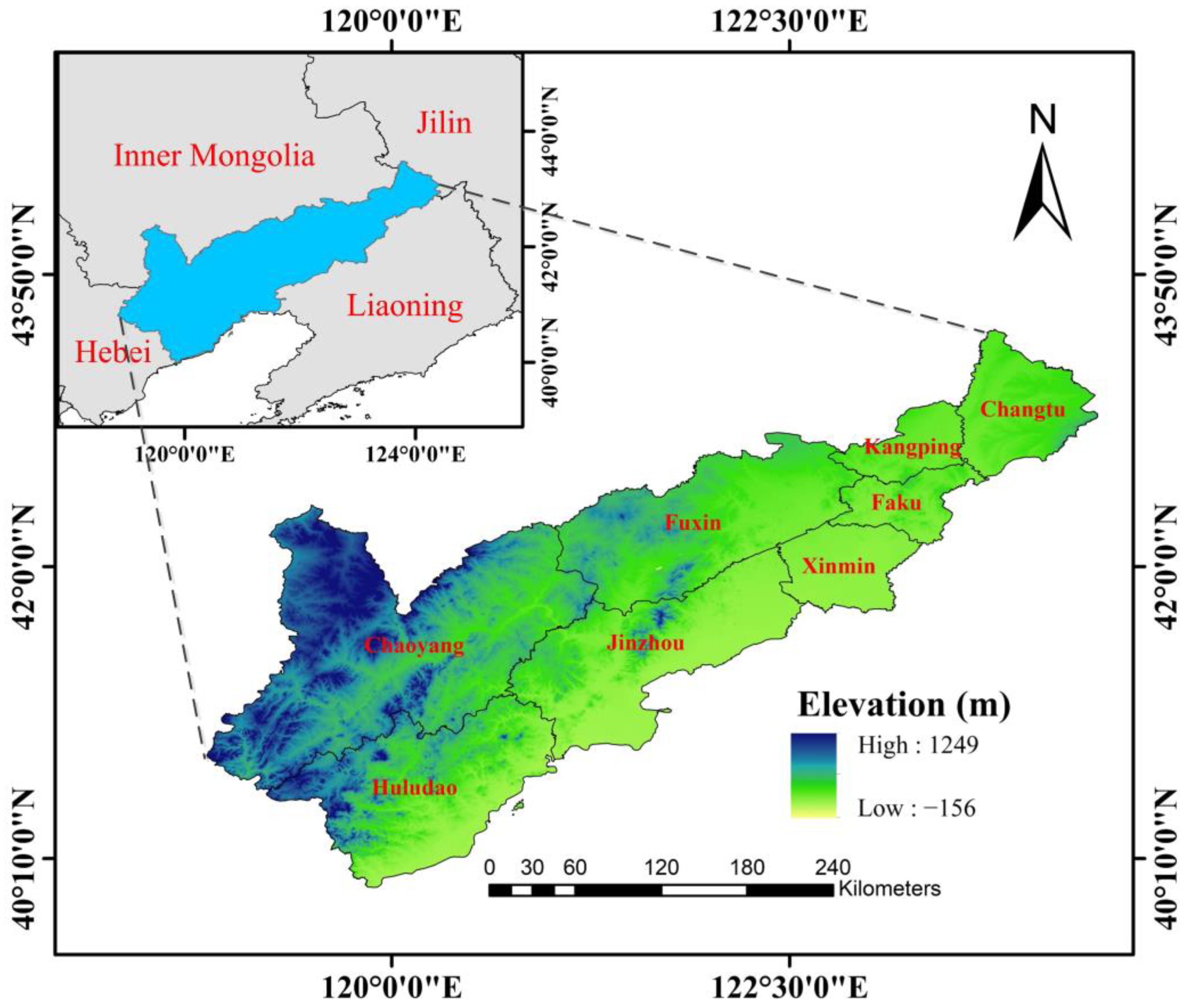
Figure 1. The study area.
Forests 15 00288 g001
Figure 2. The spatial distribution of sample points.
Forests 15 00288 g002
Figure 3. Examples of sample blocks used in deep learning models. The first row shows the remote sensing images. The second row contains the corresponding labels. In the visualization, coniferous forests are depicted in green, while other land types are depicted in black.
Forests 15 00288 g003
Figure 4. Workflow of this study.
Forests 15 00288 g004
Figure 5. The principle of multi-classifier fusion.
Forests 15 00288 g005
Figure 6. The spectral reflectance of different land-cover types. (a) The four bands spectral reflectance of Gaofen-1. (b) Backscattering coefficient values for two polarization modes (VH and VV) of the Sentinel-1.
Forests 15 00288 g006
Figure 7. The outcomes of extracting coniferous forests in five areas using different classifiers (U2-Net, Resnet-50, SVM, RF, and MCF). (ae) The remote sensing images of the five selected subareas with a spatial resolution of 0.5 m. (a1e1) The coniferous forest results extracted using U2-Net. (a2e2) The coniferous forest results extracted using Resnet-50. (a3e3) The coniferous forest results extracted using SVM. (a4e4) The coniferous forest results extracted using RF. (a5e5) The coniferous forest results extracted using MCF.
Forests 15 00288 g007
Figure 8. The outcomes of coniferous forest extraction utilizing different combinations. (ac) The remote sensing images of there selected subareas with a spatial resolution of 0.5 m. (a1c1) The results extracted using Gaofen-1 and Sentinel-1 together. (a2c2) The results extracted using Gaofen-1 alone.
Forests 15 00288 g008
Figure 9. The coniferous forest distribution maps of five subareas obtained using two products (MCF and GLC_FCS30). (ae) The remote sensing images of five selected subareas with a spatial resolution of 0.5 m. (a1e1) The coniferous forest results extracted by MCF. (a2e2) The coniferous forest distribution maps from GLC_FCS30.
Forests 15 00288 g009
Figure 10. The coniferous forest area of northwestern Liaoning calculated from MCF and GLC_FCS30.
Forests 15 00288 g010
Figure 11. The distribution of the coniferous forests in northwestern Liaoning. (ac) Three subareas selected to display the coniferous forest extraction results, which located in the north, northeast and south of the study area.
Forests 15 00288 g011
Table 1. The specific descriptions of remote-sensing images used for coniferous forest extraction.
SatellitesBand Wavelength (µm)Spatial Resolution (m)Revisit Time (Day)Period
Gaofen-1 WFVBand 1 (Blue)0.45–0.52164 1 November 2019~20 April 2020
Band 2 (Green)0.52–0.5916
Band 3 (Red)0.63–0.6916
Band 4 (NIR)0.77–0.8916
Sentinel-1VV/105
VH/
Table 2. The information of samples used in this paper.
ID CategoryNumber
1Point samplesConiferous forest/416
Non-coniferous forestCultivated land, grassland, and bare land706
Water322
Other woodland439
Construction land1221
Total3104
2Block samplesConiferous forest/20
Non-coniferous forest
Table 3. The extraction accuracies of the five classification algorithms (U2-Net, Resnet-50, SVM, RF, and MCF).
ClassifierF1_Score (%)Precision (%)Recall (%)OA (%)Kappa
U2-Net97.196.398.097.60.960
Resnet-5096.094.597.696.90.944
SVM95.692.898.596.90.932
RF90.184.596.593.30.850
MCF98.197.998.398.60.970
Table 4. Accuracy in identifying coniferous forests using different data sources (Sentinel-1 + Gaofen-1 and Gaofen-1).
Data SourceF1_Score (%)Precision (%)Recall (%)OA (%)Kappa
Gaofen-1 + Sentinel-198.197.998.398.60.970
Gaofen-197.296.697.697.50.962
Table 5. The area information of the five cities and three counties in the study area.
NameNon-Coniferous Forest (km2)Coniferous Forest (km2)Total (km2)Proportion (%)
Chaoyang16,877.232839.5519,716.7814.40
Huludao9068.631521.9610,590.5914.37
Fuxin9544.86764.7210,309.587.42
Jinzhou9427.17590.7510,017.925.90
Changtu4181.11142.274323.383.29
Xinmin3282.3415.863298.200.48
Faku2201.4278.592280.013.45
Kangping2105.2959.962165.252.77
Total56,688.056013.6762,701.719.59
Disclaimer/Publisher’s Note: The statements, opinions and data contained in all publications are solely those of the individual author(s) and contributor(s) and not of MDPI and/or the editor(s). MDPI and/or the editor(s) disclaim responsibility for any injury to people or property resulting from any ideas, methods, instructions or products referred to in the content.