Article

Monitoring Forest Diversity under Moso Bamboo Invasion: A Random Forest Approach

1
China National Bamboo Research Center, Key Laboratory of Bamboo Forest Ecology and Resource Utilization of National Forestry and Grassland Administration, Hangzhou 310012, China
2
College of Forestry, Nanjing Forestry University, Nanjing 210037, China
3
Zhejiang Forestry-Fund Management Center, Hangzhou 310012, China
*
Author to whom correspondence should be addressed.
Forests 2024, 15(2), 318; https://doi.org/10.3390/f15020318
Submission received: 8 January 2024 / Revised: 28 January 2024 / Accepted: 5 February 2024 / Published: 7 February 2024
(This article belongs to the Section Forest Ecology and Management)

Abstract

:
Moso bamboo (Phyllostachys edulis) is a crucial species among the 500 varieties of bamboo found in China and plays an important role in providing ecosystem services. However, remote sensing studies on the invasion of Moso bamboo, especially its impact on forest biodiversity, are limited. Therefore, we explored the feasibility of using Sentinel-2 multispectral data and digital elevation data from the Shuttle Radar Topography Mission and random forest (RF) algorithms to monitor changes in forest diversity due to the spread of Moso bamboo. From October to November 2019, researchers conducted field surveys on 100 subtropical forest plots in Zhejiang Province, China. Four biodiversity indices (Margalef, Shannon, Simpson, and Pielou) were calculated from the survey data. Subsequently, after completing 100 epochs of training and testing, we developed the RF prediction model and assessed its performance using three key metrics: coefficient of determination, root mean squared error, and mean absolute error. Our results showed that the RF model has a strong predictive ability for all indices except for the Pilou index, which has an average predictive ability. These results demonstrate the feasibility of using remote sensing to monitor forest diversity changes caused by the spreading of Moso bamboo.

1. Introduction

Bamboo forests provide essential ecosystem services and play an important role in the terrestrial carbon cycle. Of the approximately 500 species of bamboo in China, Moso bamboo (Phyllostachys edulis) is one of the most important in terms of its distribution, timber value, and other economic benefits [1]. However, Moso bamboo invasion poses a serious threat to ecosystem processes and functions [2]. Indeed, bamboo expansion can impact forest species composition, structure, and diversity [3] and alter the basic physical and chemical properties of the soil [4,5,6,7]. Thus, reliable and comprehensive information on the status and trends of forest diversity during the Moso bamboo invasion is urgently required.
Traditional efforts to monitor forest plant diversity have relied heavily on fieldwork to calculate biodiversity indices for forest vegetation [8,9]. Biodiversity estimation requires careful consideration of the sampling method, as well as factors such as sampling objective, sampling location, time and mode of sampling, size and number of sampling units, and random or systematically selected sampling units [10]. Traditional field sampling also involves significant time costs and human resources and can be very expensive when large areas are sampled [10,11]. In contrast, remote sensing can provide consistent and objective data over large areas, providing an efficient and cost-effective method for large-scale biodiversity monitoring [10,12].
Recent developments in satellite remote sensing technology offer the potential to link satellite observations with ground-based measurements of biodiversity. In 2015, the European Space Agency launched Sentinel-2, a new satellite constellation for the Copernicus program. Sentinel-2 has a greater swath width (290 km) and spatial resolution (4 bands at 10 m, 6 bands at 20 m, and 3 bands at 60 m spatial resolution) than previous satellites, spectral resolution (13 bands including visible, red-edge, near-infrared, and short-wave infrared), and temporal resolution (3–5 day revisit) [13]. In addition, using the free atmospheric correction tool within the Sentinel Application Platform software (version 9.0, development by European Space Agency) can improve the Top-Of-Atmosphere (TOA) reflectance images to Bottom-of-Atmosphere (BOA) reflectance images [14,15]. The longer wavelength red-edge bands present in Sentinel-2 data contribute significantly to the effectiveness of vegetation monitoring [16]. However, Sentinel-2 cannot be compared to hyperspectral instruments that typically carry hundreds of spectral bands, which is known as the spectral scale problem [17]. Additionally, as the spatial resolution remains limited (relative to individual canopy size), using Sentinel-2 measurements to detect species diversity is challenging because each pixel may include multiple individuals from different species, which is known as the spatial scale problem [10], as well as the soil background [18,19].
Most research on bamboo invasion has focused on the invasion mechanisms [20,21], effects on plants [22,23], and effects on soil physicochemical properties and microorganisms [4,5,6,24]; few studies have used remote sensing techniques to investigate bamboo invasion, especially its effect on forest biodiversity. To address this research gap, we employed Sentinel-2 multispectral data and Shuttle Radar Topography Mission (SRTM) digital elevation data to investigate the feasibility of using the random forest (RF) algorithm in monitoring the changes in forest diversity caused by Moso bamboo invasion. The specific objectives of this study were to (1) assess the performance of the RF algorithm for predicting forest diversity changes caused by Moso bamboo invasion and (2) identify the relative importance of key variables (spectral indices, vegetation indices, and topographic feature variables) in the remote sensing model.

2. Materials and Methods
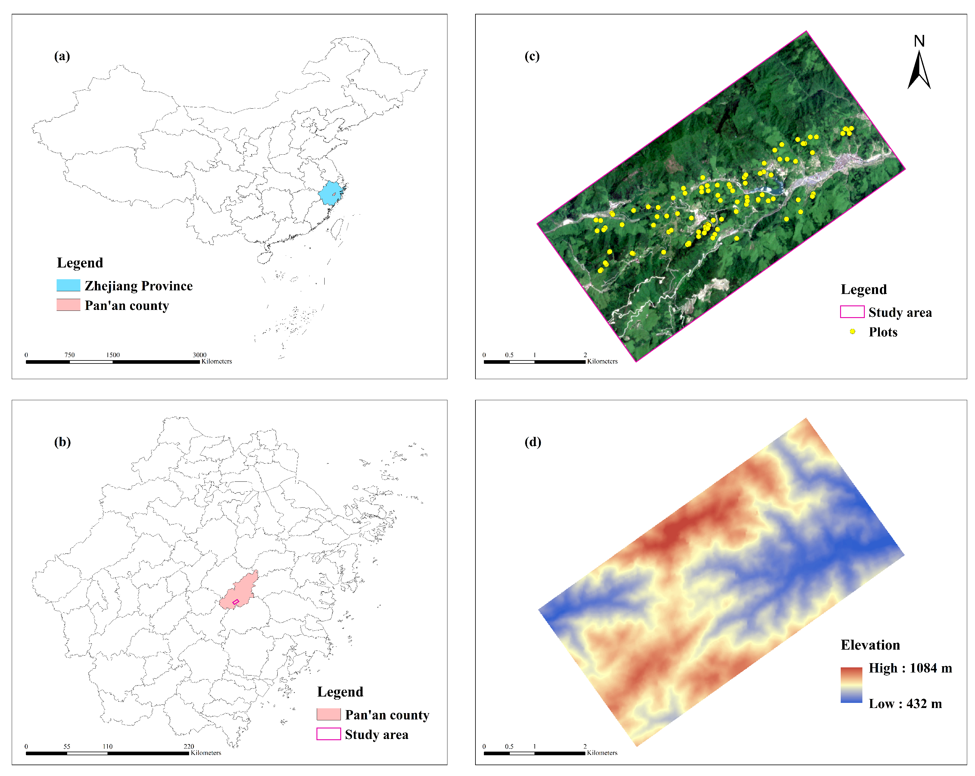
2.1. Study Area

The study area is situated in Xigao Village, Pan’an County, Jinhua City, Zhejiang Province, China (28°55′20.1″ N, 120°29′07.4″ E) (Figure 1). Since the 1950s, the area has been predominantly covered by broad-leaved (evergreen and deciduous), coniferous, and mixed broad-leaved and coniferous forests. Bamboo cultivation was not previously practiced in this region in accordance with government policies. However, in recent decades, the demand for bamboo has increased because of social and economic factors, leading to a significant rise in bamboo cultivation near the villages in the study area. Nevertheless, the declining economic benefits of bamboo production have led to many of these planted bamboo forests being abandoned in recent years. These unmanaged bamboo forests have subsequently encroached upon adjacent natural forests, resulting in transitional areas characterized by a mix of bamboo and secondary forests. Field surveys indicate that forests in the study area comprise approximately 15 major tree species, namely Phyllostachys edulis, Cunninghamia lanceolata, Pinus massoniana, Castanopsis sclerophylla, Castanopsis eyrei, Cryptomeria japonica, Sassafras tzumu, Houpoea officinalis, Schima superba, Liriodendron chinense, Liquidambar formosana, Lindera glauca, Camphora officinarum, Choerospondias axillaris, and Quercus glauca.

2.2. Remote Sensing Data

2.2.1. Pre-Processing and Extracting Features from Sentinel-2 Satellite Images

The study site is located in southeastern China, where rainfall is frequent. We chose images with as little cloud cover as possible. Therefore, a Sentinel-2 L1C MSI satellite image with tile number T51RTN was downloaded from the European Space Agency and collected on 24 May 2022 (https://scihub.copernicus.eu/dhus/#/home). The image comprises 100 km 2 of tiles using the UTM/WGS84 projection. Atmospheric correction was applied to the Sentinel-2 L1C scene using the Sen2Cor plug-in of Sentinel Application Platform software. In this process, Top-Of-Atmosphere (TOA) reflectance images were converted to Bottom-of-Atmosphere (BOA) reflectance images.
We selected only the 10 m and 20 m spectral bands of the Sentinel-2 satellite, with the other 60 m spatial resolution spectral bands (1, 9, and 10) dedicated to atmospheric correction and cloud screening. At 10 m, four spectral bands are available: blue (B2), green (B3), red (B4), and near-infrared (B8). At 20 m, six spectral bands are available: red-edge (B5, B6, and B7), near-infrared (B8A), and short-wave infrared (B11 and B12). All 20 m spectral bands were resampled to 10 m using the nearest neighbor strategy. The precise characteristics of the Sentinel-2 spectral bands are summarized in Table 1.

2.2.2. Vegetation Indices

Vegetation indices play a crucial role in estimating forest parameters through remote sensing [25,26,27]. Therefore, in addition to spectral values, we used the raster calculation tool to calculate the following vegetation indices from the raw reflectance values: normalized difference vegetation index (NDVI), normalized difference water index (NDWI), carotenoid reflectance index 1 (CRI1), green difference vegetation index (GDVI), green normalized difference vegetation index (GNDVI), green ratio vegetation index (GRVI), green chlorophyll index (CIgreen), red green ratio index (RGRI), difference vegetation index (DVI), non-linear index (NLI), soil adjusted vegetation index (SAVI), simple ratio index (SRI), and enhanced vegetation index (EVI). The detailed formulas for calculating these vegetation indices are listed in Table 2.

2.2.3. Pre-Processing and Extracting Features from SRTM Topographic Data

NASA’s production of SRTM digital elevation data signifies a notable progression in the realm of global digital elevation mapping. This dataset facilitates access to superior elevation information, particularly covering extensive regions within the tropics and other developing areas [40]. The SRTM topographic data, sourced from the USGS EROS Data Center on 5 August 2022 (https://earthexplorer.usgs.gov/), offer comprehensive global coverage. These elevation data offer global coverage with void-filled information at a resolution of 1 arc-second (approximately 30 m) [41], comprising a high-resolution dataset on a worldwide scale. To ensure consistency with the image data, SRTM topographic data were reprojected into UTM/WGS84 from the original projection system of GCS/WGS84. We also resampled the SRTM data from 30 m resolution to 10 m resolution and extracted the elevation, slope, and aspect using ArcGIS software (version 10.8, ESRI, Redlands, CA, USA).

2.3. Reference Data

2.3.1. Field Data

Field datasets were collected during the autumn of 2019 (October–November). Field surveys were conducted in 100 quadrants located in subtropical forests. Each quadrant measured 100 m 2 (10 m × 10 m), equivalent to one pixel of Sentinel-2 satellite imagery. To minimize positioning errors, we used a high-precision Global Navigation Satellite System to record the coordinates of the center and one corner of each plot. Subsequently, we identified the tree species present in each quadrant and documented all individual trees with a diameter at breast height >8 cm. This included trees from the canopy layer, as well as some larger intermediate and bottom layer individuals. The tree species data recorded for each quadrant were then used to calculate the biodiversity index.

2.3.2. Diversity Measurement

In field surveys, forest tree species are identified at the individual level, taking into account the richness and homogeneity of tree species. However, a single biodiversity index cannot accurately describe the forest diversity. The Margalef index serves as an easy species diversity indicator because it highlights the importance of species richness. In contrast, the Shannon index is predominantly employed to gauge the extent of species diversity within a community, while the Simpson index, often referred to as the dominance index, quantifies concentration. Finally, the Pielou index is utilized to assess the evenness of species distribution within a community. Therefore, in this study, we calculated the Margalef [42], Shannon [43], Simpson [44], and Pielou [45] biodiversity indices for a sample of 100 plots using the following formulas:
D M = S 1 ln N
H = i = 1 s ( p i ln p i )
D s = 1 i = 1 s p i 2
E = H ln S
where DM is the Margalef index, H′ is the Shannon index, Ds is the Simpson index, E is the Pielou index, S is the number of tree species in field, and pi is the ratio of individuals of species i divided by all individual trees N of all species.

2.4. RF Algorithm

RF is a machine learning algorithm developed by Breiman that combines the results of multiple decision trees to reach a single conclusion [46]. RF is an extension of the bagging method and employs both bagging and feature randomness to create a forest of uncorrelated decision trees. The process for constructing the RF model was as follows. First, samples were randomly selected from the training set using the bootstrap method until the number of samples in the sample subset equaled the number of training samples. Some samples may be selected more than once, and others may not be selected at all. Typically, approximately 36.8% of the training samples are never selected and are referred to as out-of-bag samples, which form an unbiased internal estimate of the generalization error [47]. Second, a number of trees were constructed using the data in the subset of samples. Several variables were chosen randomly. The best split of the node was determined based on the Gini impurity of all selected variables. The variable that produced the best (lowest) Gini impurity and the corresponding threshold were selected as the criteria for node splitting. Finally, the results of all trees were combined, and their average was used to determine the final output. The RF algorithm is straightforward to implement and typically requires only two hyperparameters, namely, ntree and mtry. The ntree hyperparameter specifies the number of trees, whereas the mtry hyperparameter indicates the number of variables used in each node segmentation.

2.5. Model Evaluation and Performance Metrics

To ensure the accuracy and reliability of our results, we conducted a total of 100 training and testing epochs. This extensive process allowed us to minimize any potential misalignment or inconsistencies arising from dataset segmentation. To begin, we divided our dataset into two subsets: a training set and a test set. The training set accounted for 70% of the data and, therefore, provided a substantial amount of information for the model to learn from. The remaining 30% was allocated to the test set, which served as an independent evaluation for assessing model performance. Three key metrics were used to evaluate the effectiveness of the model: coefficient of determination ( R 2 ), root mean squared error (RMSE), and mean absolute error (MAE). RMSE is defined as the square root of the mean of the summed squared regression residuals [48]. MAE is defined as the average of the absolute errors [49]. These metrics are commonly used in regression analysis to measure the accuracy and precision of predictions and are calculated as follows:
R 2 = 1 i = 1 n ( y i ^ y i ) 2 i = 1 n ( y i ^ y i ¯ ) 2
RMSE = i = 1 n ( y i ^ y i ) 2 n
MAE = 1 n i = 1 n y i ^ y i
where n is the number of samples, y ^ i is the model prediction, yi is the field observation, and y ¯ is the arithmetic mean of all observations.

3. Results

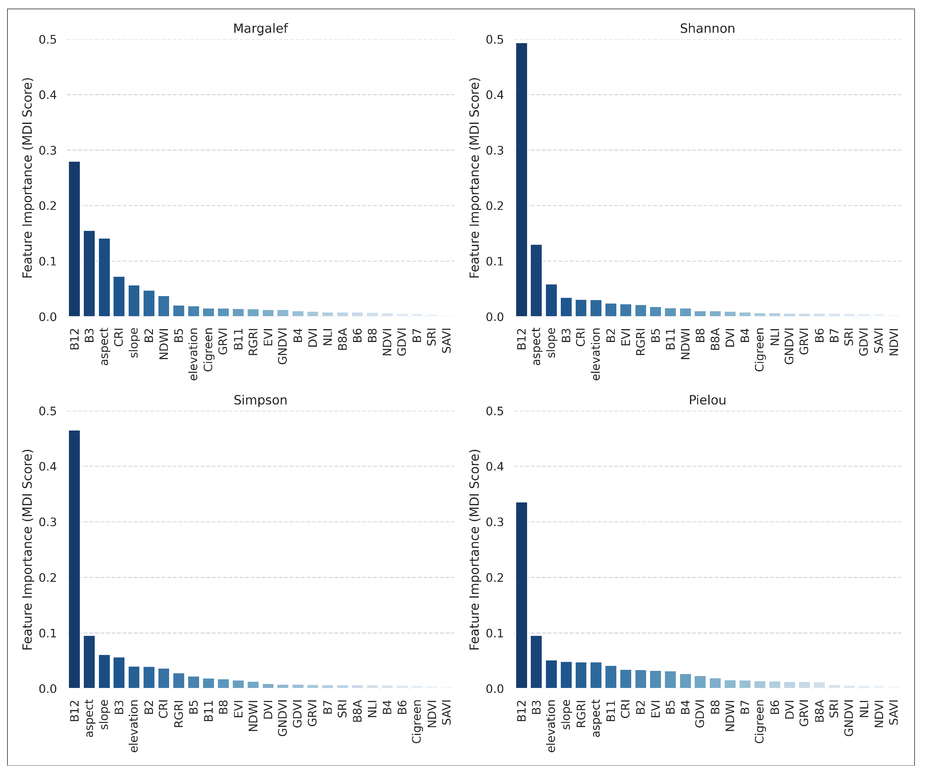
3.1. Importance of Variables

For the variable importance analysis, we calculated the mean decrease in impurity and ranked the variables according to this value to determine their relative importance. Figure 2 shows the ranking results of variable importance for the four diversity indices.
We then selected the top 10 ranked variables to reduce complexity and computational effort. For the Margalef index, we selected B12, B3, aspect, CRI, slope, B2, NDWI, B5, elevation, and Cigreen. For the Shannon index, we selected B12, aspect, slope, B3, CRI, elevation, B2, EVI, RGRI, and B5. For the Simpson index, we selected B12, aspect, slope, B3, elevation, B2, CRI, RGRI, B5, and B11. For the Pielou index, we selected B12, B3, elevation, slope, RGRI, aspect, B11, CRI, B2, and EVI.

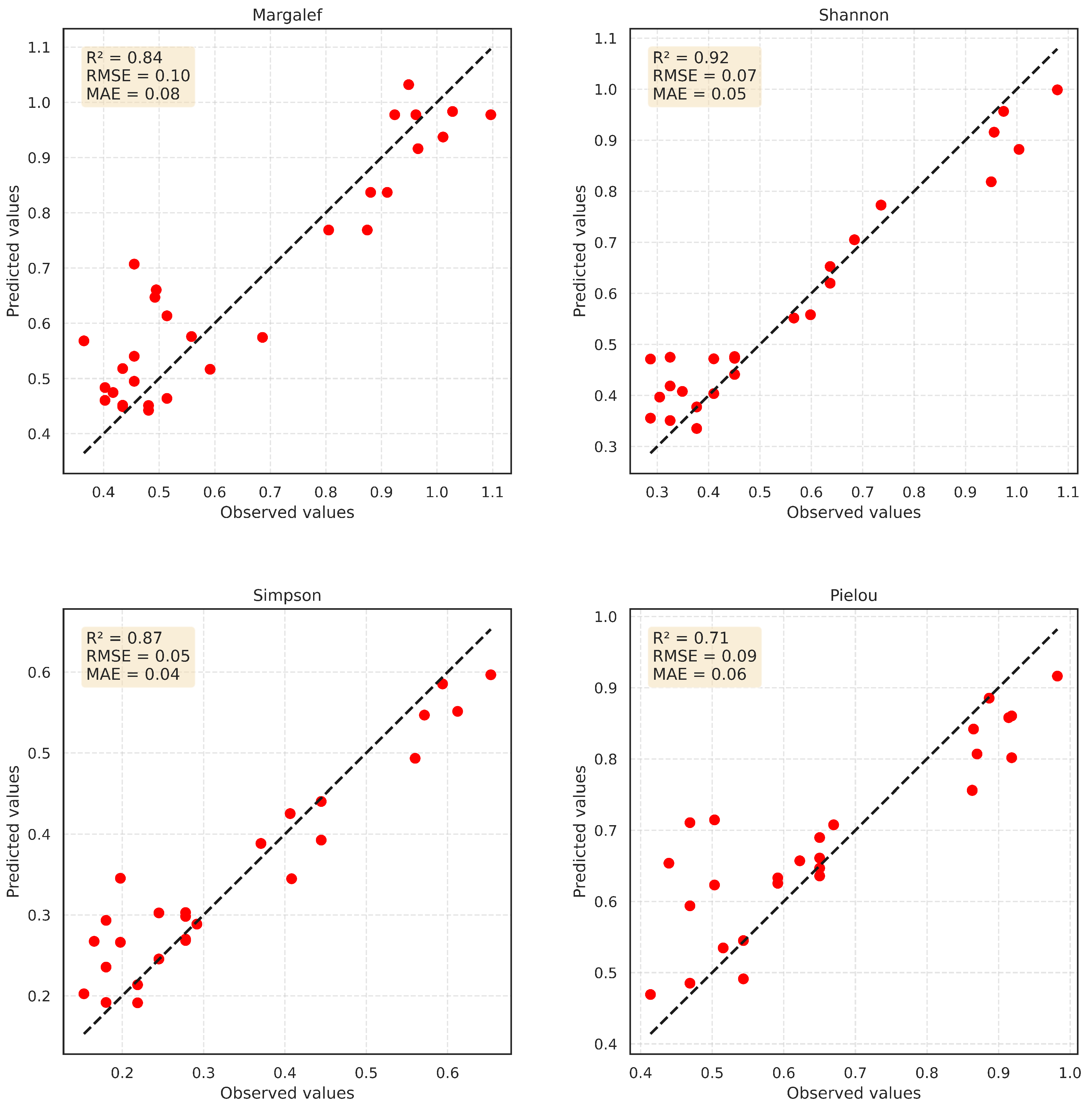
3.2. Model Performance

According to the performance metrics for the four RF prediction models, the mean R 2 , RMSE, and MAE values for the Margalef, Shannon, Simpson, and Pielou indices were 0.67, 0.73, 0.69, and 0.55; 0.14, 0.12, 0.08, and 0.11; and 0.10, 0.08, 0.06, and 0.08, respectively. These results indicate that the RF model had strong predictive ability for the Margalef, Shannon, and Simpson indices and average predictive ability for the Pielou index.
Scatterplots provide a visual indication of the predictive performance of the model. Therefore, we produced scatterplots of predicted and observed values at typical levels of the models (Figure 3). The results showed that the model predicts the Margalef, Shannon, and Simpson diversity indices well and the Pielou index moderately well. In the case of the Margalef index, the predicted values were significantly higher than the observed values in areas with low diversity indices. For the Shannon and Simpson indices, the predicted values were significantly higher than the observed values in areas with low diversity indices and lower than the observed values in areas with high diversity indices. For the Pielou index, the predicted values were inaccurate for areas with low diversity indices and significantly lower than the observed values for areas with high diversity indices.

4. Discussion

4.1. Importance of Variables

The selection of appropriate variables for remote sensing is crucial for estimating forest diversity. Variables used as input parameters before modeling can be classified into three categories: spectral indices, vegetation indices, and topographic features. Here, we used RF importance analysis to identify the optimal variables for remote sensing. Four new bands (B5, B6, B7, and B8A) in the red-edge and near-infrared regions provide unprecedented spectral features that are highly sensitive to biophysical and biochemical responses of vegetation, which are essential for mapping vegetation features [50]. However, in this study, the classical and shortwave infrared bands (B2, B3, B11, and B12) also showed a critical role in addition to the B5 band. The superior performance of the B2 and B3 bands was correlated with chlorophyll or leaf nitrogen concentration. A previous study has reported a strong correlation between visible light bands and chlorophyll or leaf nitrogen concentration [51]. In particular, the 440 nm and 573 nm reflectances are most closely related to leaf nitrogen concentration [52]. The near-infrared band of the electromagnetic spectrum is most strongly reflected by vegetation, but it does not reveal any details about the underlying soil, whereas the short-wave infrared bands (B11, B12) can distinguish between vegetation and soil [14]. Theoretically, the reflectance in the short-wave infrared bands (B11, B12) is predominantly affected by leaf water content [15,29], and around 1450 nm and 1950 nm are most pronounced [53]. According to previous studies, these absorption bands saturate at higher water contents, and the intermediate absorption region around 1650 nm and 2200 nm is sensitive to differences in leaf water content [54,55]. This coincides with the B11 and B12 bands. Therefore, the observation that B2, B3, B5, B11, and B12 have high importance for biodiversity is plausible.
CRI1 is an important vegetation index used in this study. It has been found that the reciprocal of spectral reflectance near 510 nm is the most sensitive to carotenoid (Car) content, but chlorophyll (Chl) also affects these spectral bands; therefore, to eliminate the effect of Chl on spectral reflectance near 510 nm, 550 nm was chosen to establish CRI1 for assessing Car content [30]. Previous studies have shown that Car is associated with plant responses to environmental stresses [56].
In this study, we used slope, slope direction, and elevation terrain feature variables. All three variables showed high importance according to the RF importance analysis. Topography, including slope, aspect, and elevation factors, has a significant effect on species composition in subtropical forests [57]. In addition, the combination of slope and aspect affects plant invasion [58,59]. In this study, the invasion of Moso bamboo differed significantly at different elevations; Moso bamboo proportion gradually decreased with increasing elevation, which has also been confirmed previously [60]. Thus, topographic factors influence biodiversity in the study area.

4.2. Model Performance

Predictive model performance metrics were based on three RF predictions. The mean R 2 value assesses the fit of the model, with higher values indicating a better fit of the model to the data. In our study, the average R 2 values indicated that the RF model had a strong predictive ability for the Margalef, Shannon, and Simpson indices, i.e., it could capture abundant information to accurately predict the diversity indices. However, the Pielou index had an average predictive ability with a lower R 2 value than the other indices. To further assess the performance of the model, we calculated the average of the RMSE and MAE, which confirm the findings of the R 2 values and indicate good model performance for the Margalef, Shannon, and Simpson indices. Again, the prediction accuracy was lower for the Pielou index. Moreover, scatter plots were generated to visually present the relationship between predicted and observed values and further assess model predictive performance. Similarly, the model predictions were accurate for the Margalef, Shannon, and Simpson indices, with predicted values being very close to the observed values, indicating that the predictions of the model were generally consistent with the actual data. However, for the Pielou index, the scatterplot showed significant differences between the predicted and observed values, especially for areas with low diversity indices, highlighting the tendency of the model to overestimate or underestimate certain diversity indices under different scenarios. These results provide insights into model performance and its impact on predicting biodiversity indices.

4.3. Sustainable Forest Management

Moso bamboo is widely distributed across East and Southeast Asia [61]. Its robust invasiveness stems from the lateral spread of its rhizome system underground, which facilitates rapid invasion into neighboring broadleaf or coniferous forests [62,63]. Research has consistently demonstrated that bamboo invasions can detrimentally impact the structure, function, and stability of the invaded ecosystem [3,6,64]. The need to monitor Moso bamboo invasion has become increasingly urgent given its potential adverse effects on ecosystems, especially with the promotion of its cultivation. Our study introduces a monitoring methodology that offers practical insights that are crucial for the development of sustainable forest management strategies and the conservation of biodiversity.

5. Conclusions

In this study, we explored the impact of Moso bamboo invasion on forest diversity using a combination of Sentinel-2 multispectral data, SRTM digital elevation data, and the RF algorithm. The RF prediction model, whose performance was determined using the average R 2 , RMSE, and MAE values, showed strong predictive capabilities for the Margalef, Shannon, and Simpson indices and average predictive capabilities for the Pielou index. Thus, our findings demonstrate the feasibility of using this remote sensing technique to monitor forest diversity changes caused by the Moso bamboo invasion. This study is important for the development of sustainable forest management strategies as well as for the conservation of biodiversity.

Author Contributions

Conceptualization, X.D. and A.W.; methodology, Z.W., X.D. and X.X.; software, Z.W.; validation, Z.W., X.D., G.L., Y.B., X.Z. and Y.N.; formal analysis, Z.W.; investigation, Z.W., A.W., G.L., X.Z. and Y.N.; resources, X.D.; data curation, Z.W.; writing—original draft preparation, Z.W.; writing—review and editing, Z.W. and X.D.; visualization, Z.W.; supervision, X.D., A.W. and Y.B.; project administration, X.D.; funding acquisition, X.D. and A.W. All authors have read and agreed to the published version of the manuscript.

Funding

This research was funded by the Key Research and Development Program of Zhejiang Province (2020C02008) and the Fundamental Research Funds of CAF (CAFYBB2021MA011).

Data Availability Statement

The datasets are available from the corresponding author on reasonable request.

Conflicts of Interest

The authors declare no conflict of interest.

References

  1. Li, P.; Zhou, G.; Du, H.; Lu, D.; Mo, L.; Xu, X.; Shi, Y.; Zhou, Y. Current and Potential Carbon Stocks in Moso Bamboo Forests in China. J. Environ. Manag. 2015, 156, 89–96. [Google Scholar] [CrossRef]
  2. Song, Q.N.; Ouyang, M.; Yang, Q.P.; Lu, H.; Yang, G.Y.; Chen, F.S.; Shi, J.M. Degradation of Litter Quality and Decline of Soil Nitrogen Mineralization after Moso Bamboo (Phyllostachys pubscens) Expansion to Neighboring Broadleaved Forest in Subtropical China. Plant Soil 2016, 404, 113–124. [Google Scholar] [CrossRef]
  3. Ouyang, M.; Yang, Q.; Chen, X.; Yang, G.; Shi, J.; Fang, X. Effects of the Expansion of Phyllostachys edulis on Species Composition, Structure and Diversity of the Secondary Evergreen Broad-Leaved Forests. Biodivers. Sci. 2016, 24, 649. [Google Scholar] [CrossRef]
  4. Shinohara, Y.; Otsuki, K. Comparisons of Soil-Water Content between a Moso Bamboo (Phyllostachyspubescens) Forest and an Evergreen Broadleaved Forest in Western Japan. Plant Species Biol. 2015, 30, 96–103. [Google Scholar] [CrossRef]
  5. Wu, C.; Mo, Q.; Wang, H.; Zhang, Z.; Huang, G.; Ye, Q.; Zou, Q.; Kong, F.; Liu, Y.; Wang, G.G. Moso Bamboo (PhyllostachysEdulis (Carriere) J. Houzeau) Invasion Affects Soil Phosphorus Dynamics in Adjacent Coniferous Forests in Subtropical China. Ann. For. Sci. 2018, 75, 24. [Google Scholar] [CrossRef]
  6. Zhao, Y.; Liang, C.; Shao, S.; Chen, J.; Qin, H.; Xu, Q. Linkages of Litter and Soil C:N:P Stoichiometry with Soil Microbial Resource Limitation and Community Structure in a Subtropical Broadleaf Forest Invaded by Moso Bamboo. Plant Soil 2021, 465, 473–490. [Google Scholar] [CrossRef]
  7. Ouyang, M.; Tian, D.; Pan, J.; Chen, G.; Su, H.; Yan, Z.; Yang, Q.; Ji, C.; Tang, Z.; Fang, J. Moso Bamboo (Phyllostachysedulis) Invasion Increases Forest Soil pH in Subtropical China. CATENA 2022, 215, 106339. [Google Scholar] [CrossRef]
  8. Madonsela, S.; Cho, M.A.; Ramoelo, A.; Mutanga, O. Remote Sensing of Species Diversity Using Landsat 8 Spectral Variables. ISPRS J. Photogramm. Remote Sens. 2017, 133, 116–127. [Google Scholar] [CrossRef]
  9. Arekhi, M.; Yılmaz, O.Y.; Yılmaz, H.; Akyüz, Y.F. Can Tree Species Diversity Be Assessed with Landsat Data in a Temperate Forest? Environ. Monit. Assess. 2017, 189, 586. [Google Scholar] [CrossRef]
  10. Wang, R.; Gamon, J.A. Remote Sensing of Terrestrial Plant Biodiversity. Remote Sens. Environ. 2019, 231, 111218. [Google Scholar] [CrossRef]
  11. Levrel, H.; Fontaine, B.; Henry, P.Y.; Jiguet, F.; Julliard, R.; Kerbiriou, C.; Couvet, D. Balancing State and Volunteer Investment in Biodiversity Monitoring for the Implementation of CBD Indicators: A French Example. Ecol. Econ. 2010, 69, 1580–1586. [Google Scholar] [CrossRef]
  12. Nagendra, H. Using Remote Sensing to Assess Biodiversity. Int. J. Remote Sens. 2001, 22, 2377–2400. [Google Scholar] [CrossRef]
  13. Drusch, M.; Del Bello, U.; Carlier, S.; Colin, O.; Fernandez, V.; Gascon, F.; Hoersch, B.; Isola, C.; Laberinti, P.; Martimort, P.; et al. Sentinel-2: ESA’s Optical High-Resolution Mission for GMES Operational Services. Remote Sens. Environ. 2012, 120, 25–36. [Google Scholar] [CrossRef]
  14. Wai, P.; Su, H.; Li, M. Estimating Aboveground Biomass of Two Different Forest Types in Myanmar from Sentinel-2 Data with Machine Learning and Geostatistical Algorithms. Remote Sens. 2022, 14, 2146. [Google Scholar] [CrossRef]
  15. Chen, L.; Wang, Y.; Ren, C.; Zhang, B.; Wang, Z. Optimal Combination of Predictors and Algorithms for Forest Above-Ground Biomass Mapping from Sentinel and SRTM Data. Remote Sens. 2019, 11, 414. [Google Scholar] [CrossRef]
  16. Imran, A.B.; Khan, K.; Ali, N.; Ahmad, N.; Ali, A.; Shah, K. Narrow Band Based and Broadband Derived Vegetation Indices Using Sentinel-2 Imagery to Estimate Vegetation Biomass. Glob. J. Environ. Sci. Manag.-GJESM 2020, 6, 97–108. [Google Scholar] [CrossRef]
  17. Ma, X.; Mahecha, M.D.; Migliavacca, M.; van der Plas, F.; Benavides, R.; Ratcliffe, S.; Kattge, J.; Richter, R.; Musavi, T.; Baeten, L.; et al. Inferring Plant Functional Diversity from Space: The Potential of Sentinel-2. Remote Sens. Environ. 2019, 233, 111368. [Google Scholar] [CrossRef]
  18. Gholizadeh, H.; Gamon, J.A.; Zygielbaum, A.I.; Wang, R.; Schweiger, A.K.; Cavender-Bares, J. Remote Sensing of Biodiversity: Soil Correction and Data Dimension Reduction Methods Improve Assessment of α-Diversity (Species Richness) in Prairie Ecosystems. Remote Sens. Environ. 2018, 206, 240–253. [Google Scholar] [CrossRef]
  19. Wang, R.; Gamon, J.A.; Schweiger, A.K.; Cavender-Bares, J.; Townsend, P.A.; Zygielbaum, A.I.; Kothari, S. Influence of Species Richness, Evenness, and Composition on Optical Diversity: A Simulation Study. Remote Sens. Environ. 2018, 211, 218–228. [Google Scholar] [CrossRef]
  20. Okutomi, K.; Shinoda, S.; Fukuda, H. Causal Analysis of the Invasion of Broad-Leaved Forest by Bamboo in Japan. J. Veg. Sci. 1996, 7, 723–728. [Google Scholar] [CrossRef]
  21. Wang, Y.; Bai, S.; Binkley, D.; Zhou, G.; Fang, F. The Independence of Clonal Shoot’s Growth from Light Availability Supports Moso Bamboo Invasion of Closed-Canopy Forest. For. Ecol. Manag. 2016, 368, 105–110. [Google Scholar] [CrossRef]
  22. Fukushima, K.; Usui, N.; Ogawa, R.; Tokuchi, N. Impacts of Moso Bamboo (Phyllostachyspubescens) Invasion on Dry Matter and Carbon and Nitrogen Stocks in a Broad-Leaved Secondary Forest Located in Kyoto, Western Japan. Plant Species Biol. 2015, 30, 81–95. [Google Scholar] [CrossRef]
  23. Chen, X.; Chen, X.; Huang, S.; Fang, D. Impacts of Moso Bamboo (Phyllostachys pubescens) Invasion on Species Diversity and Aboveground Biomass of Secondary Coniferous and Broad-Leaved Mixed Forest. Front. Plant Sci. 2022, 13, 1001785. [Google Scholar] [CrossRef] [PubMed]
  24. Li, Z.; Zhang, L.; Deng, B.; Liu, Y.; Kong, F.; Huang, G.; Zou, Q.; Liu, Q.; Guo, X.; Fu, Y.; et al. Effects of Moso Bamboo (Phyllostachysedulis) Invasions on Soil Nitrogen Cycles Depend on Invasion Stage and Warming. Environ. Sci. Pollut. Res. 2017, 24, 24989–24999. [Google Scholar] [CrossRef] [PubMed]
  25. Lv, Y.; Han, N.; Du, H. Estimation of Bamboo Forest Aboveground Carbon Using the RGLM Model Based on Object-Based Multiscale Segmentation of SPOT-6 Imagery. Remote Sens. 2023, 15, 2566. [Google Scholar] [CrossRef]
  26. Fang, G.; He, X.; Weng, Y.; Fang, L. Texture Features Derived from Sentinel-2 Vegetation Indices for Estimating and Mapping Forest Growing Stock Volume. Remote Sens. 2023, 15, 2821. [Google Scholar] [CrossRef]
  27. Yang, Q.; Wang, L.; Huang, J.; Lu, L.; Li, Y.; Du, Y.; Ling, F. Mapping Plant Diversity Based on Combined SENTINEL-1/2 Data—Opportunities for Subtropical Mountainous Forests. Remote Sens. 2022, 14, 492. [Google Scholar] [CrossRef]
  28. Kriegler, F.J. Preprocessing Transformations and Their Effects on Multspectral Recognition. In Proceedings of the Sixth International Symposium on Remote Sesning of Environment, Ann Arbor, MI, USA, 13–16 October 1969; pp. 97–131. [Google Scholar]
  29. Gao, B.C. NDWI—A Normalized Difference Water Index for Remote Sensing of Vegetation Liquid Water from Space. Remote Sens. Environ. 1996, 58, 257–266. [Google Scholar] [CrossRef]
  30. Gitelson, A.A.; Zur, Y.; Chivkunova, O.B.; Merzlyak, M.N. Assessing Carotenoid Content in Plant Leaves with Reflectance Spectroscopy. Photochem. Photobiol. 2002, 75, 272–281. [Google Scholar] [CrossRef]
  31. Sripada, R.P.; Heiniger, R.W.; White, J.G.; Meijer, A.D. Aerial Color Infrared Photography for Determining Early In-Season Nitrogen Requirements in Corn. Agron. J. 2006, 98, 968–977. [Google Scholar] [CrossRef]
  32. Gitelson, A.A.; Merzlyak, M.N. Signature Analysis of Leaf Reflectance Spectra: Algorithm Development for Remote Sensing of Chlorophyll. J. Plant Physiol. 1996, 148, 494–500. [Google Scholar] [CrossRef]
  33. Gitelson, A.A.; Viña, A.; Arkebauer, T.J.; Rundquist, D.C.; Keydan, G.; Leavitt, B. Remote Estimation of Leaf Area Index and Green Leaf Biomass in Maize Canopies. Geophys. Res. Lett. 2003, 30. [Google Scholar] [CrossRef]
  34. Gamon, J.A.; Surfus, J.S. Assessing Leaf Pigment Content and Activity with a Reflectometer. New Phytol. 1999, 143, 105–117. [Google Scholar] [CrossRef]
  35. Tucker, C.J. Red and Photographic Infrared Linear Combinations for Monitoring Vegetation. Remote Sens. Environ. 1979, 8, 127–150. [Google Scholar] [CrossRef]
  36. Goel, N.S.; Qin, W. Influences of Canopy Architecture on Relationships between Various Vegetation Indices and LAI and FPAR: A Computer Simulation. Remote Sens. Rev. 1994, 10, 309–347. [Google Scholar] [CrossRef]
  37. Huete, A.R. A Soil-Adjusted Vegetation Index (SAVI). Remote Sens. Environ. 1988, 25, 295–309. [Google Scholar] [CrossRef]
  38. Birth, G.S.; McVey, G.R. Measuring the Color of Growing Turf with a Reflectance Spectrophotometer1. Agron. J. 1968, 60, 640–643. [Google Scholar] [CrossRef]
  39. Huete, A.; Didan, K.; Miura, T.; Rodriguez, E.P.; Gao, X.; Ferreira, L.G. Overview of the Radiometric and Biophysical Performance of the MODIS Vegetation Indices. Remote Sens. Environ. 2002, 83, 195–213. [Google Scholar] [CrossRef]
  40. Su, H.; Shen, W.; Wang, J.; Ali, A.; Li, M. Machine Learning and Geostatistical Approaches for Estimating Aboveground Biomass in Chinese Subtropical Forests. For. Ecosyst. 2020, 7, 64. [Google Scholar] [CrossRef]
  41. Ramzan, U.; Fan, H.; Aeman, H.; Ali, M.; Al-qaness, M.A.A. Combined Analysis of PS-InSAR and Hypsometry Integral (HI) for Comparing Seismic Vulnerability and Assessment of Various Regions of Pakistan. Sci. Rep. 2022, 12, 22423. [Google Scholar] [CrossRef]
  42. Margalef, R. Information Theory in Ecology. Gen. Syst. 1958, 3, 36–71. [Google Scholar]
  43. Shannon, C.E. A Mathematical Theory of Communication. Bell Syst. Tech. J. 1948, 27, 379–423. [Google Scholar] [CrossRef]
  44. Simpson, E.H. Measurement of Diversity. Nature 1949, 163, 688. [Google Scholar] [CrossRef]
  45. Pielou, E.C. Species-Diversity and Pattern-Diversity in the Study of Ecological Succession. J. Theor. Biol. 1966, 10, 370–383. [Google Scholar] [CrossRef] [PubMed]
  46. Breiman, L. Random Forests. Mach. Learn. 2001, 45, 5–32. [Google Scholar] [CrossRef]
  47. Dube, T.; Mutanga, O.; Elhadi, A.; Ismail, R. Intra-and-Inter Species Biomass Prediction in a Plantation Forest: Testing the Utility of High Spatial Resolution Spaceborne Multispectral RapidEye Sensor and Advanced Machine Learning Algorithms. Sensors 2014, 14, 15348–15370. [Google Scholar] [CrossRef] [PubMed]
  48. Greaves, H.E.; Vierling, L.A.; Eitel, J.U.H.; Boelman, N.T.; Magney, T.S.; Prager, C.M.; Griffin, K.L. High-Resolution Mapping of Aboveground Shrub Biomass in Arctic Tundra Using Airborne Lidar and Imagery. Remote Sens. Environ. 2016, 184, 361–373. [Google Scholar] [CrossRef]
  49. Osco, L.P.; de Arruda, M.d.S.; Marcato Junior, J.; da Silva, N.B.; Ramos, A.P.M.; Moryia, É.A.S.; Imai, N.N.; Pereira, D.R.; Creste, J.E.; Matsubara, E.T.; et al. A Convolutional Neural Network Approach for Counting and Geolocating Citrus-Trees in UAV Multispectral Imagery. ISPRS J. Photogramm. Remote Sens. 2020, 160, 97–106. [Google Scholar] [CrossRef]
  50. Pandit, S.; Tsuyuki, S.; Dube, T. Estimating Above-Ground Biomass in Sub-Tropical Buffer Zone Community Forests, Nepal, Using Sentinel 2 Data. Remote Sens. 2018, 10, 601. [Google Scholar] [CrossRef]
  51. Hansen, P.M.; Schjoerring, J.K. Reflectance Measurement of Canopy Biomass and Nitrogen Status in Wheat Crops Using Normalized Difference Vegetation Indices and Partial Least Squares Regression. Remote Sens. Environ. 2003, 86, 542–553. [Google Scholar] [CrossRef]
  52. Ferwerda, J.G.; Skidmore, A.K.; Mutanga, O. Nitrogen Detection with Hyperspectral Normalized Ratio Indices across Multiple Plant Species. Int. J. Remote Sens. 2005, 26, 4083–4095. [Google Scholar] [CrossRef]
  53. Clevers, J.G.P.W.; Kooistra, L.; Schaepman, M.E. Using Spectral Information from the NIR Water Absorption Features for the Retrieval of Canopy Water Content. Int. J. Appl. Earth Obs. Geoinf. 2008, 10, 388–397. [Google Scholar] [CrossRef]
  54. Jacquemoud, S.; Ustin, S. Leaf Optical Properties; Cambridge University Press: Cambridge, UK, 2019. [Google Scholar]
  55. Hamrouni, Y.; Paillassa, E.; Chéret, V.; Monteil, C.; Sheeren, D. Sentinel-2 Poplar Index for Operational Mapping of Poplar Plantations over Large Areas. Remote Sens. 2022, 14, 3975. [Google Scholar] [CrossRef]
  56. Havaux, M. Carotenoid Oxidation Products as Stress Signals in Plants. Plant J. 2014, 79, 597–606. [Google Scholar] [CrossRef]
  57. Yang, Q.; Zhang, H.; Wang, L.; Ling, F.; Wang, Z.; Li, T.; Huang, J. Topography and Soil Content Contribute to Plant Community Composition and Structure in Subtropical Evergreen-Deciduous Broadleaved Mixed Forests. Plant Divers. 2021, 43, 264–274. [Google Scholar] [CrossRef]
  58. Kakembo, V.; Rowntree, K.; Palmer, A.R. Topographic Controls on the Invasion of Pteroniaincana (Blue Bush) onto Hillslopes in Ngqushwa (Formerly Peddie) District, Eastern Cape, South Africa. CATENA 2007, 70, 185–199. [Google Scholar] [CrossRef]
  59. Esposito, D.M.; Rodhouse, T.J.; Mata-González, R.; Hovland, M. Differential Species Responses to Aspects of Resistance to Invasion in Two Columbia Plateau-Protected Areas. Rangel. Ecol. Manag. 2019, 72, 773–782. [Google Scholar] [CrossRef]
  60. Liu, K.; Wang, A.; Zhang, S.; Zhu, Z.; Bi, Y.; Wang, Y.; Du, X. Tree Species Diversity Mapping Using UAS-based Digital Aerial Photogrammetry Point Clouds and Multispectral Imageries in a Subtropical Forest Invaded by Moso Bamboo (Phyllostachys edulis). Int. J. Appl. Earth Obs. Geoinf. 2021, 104, 102587. [Google Scholar] [CrossRef]
  61. Xu, Q.F.; Jiang, P.K.; Wu, J.S.; Zhou, G.M.; Shen, R.F.; Fuhrmann, J.J. Bamboo Invasion of Native Broadleaf Forest Modified Soil Microbial Communities and Diversity. Biol. Invasions 2015, 17, 433–444. [Google Scholar] [CrossRef]
  62. Bai, S.; Zhou, G.; Wang, Y.; Liang, Q.; Chen, J.; Cheng, Y.; Shen, R. Plant Species Diversity and Dynamics in Forests Invaded by Moso Bamboo (Phyllostachys edulis) in Tianmu Mountain Nature Reserve. Biodivers. Sci. 2013, 21, 288. [Google Scholar] [CrossRef]
  63. Liu, C.; Zhou, Y.; Qin, H.; Liang, C.; Shao, S.; Fuhrmann, J.J.; Chen, J.; Xu, Q. Moso Bamboo Invasion Has Contrasting Effects on Soil Bacterial and Fungal Abundances, Co-Occurrence Networks and Their Associations with Enzyme Activities in Three Broadleaved Forests across Subtropical China. For. Ecol. Manag. 2021, 498, 119549. [Google Scholar] [CrossRef]
  64. Liu, C.; Zheng, C.; Wang, L.; Zhang, J.; Wang, Q.; Shao, S.; Qin, H.; Xu, Q.; Liang, C.; Chen, J. Moso Bamboo Invasion Changes the Assembly Process and Interactive Relationship of Soil Microbial Communities in a Subtropical Broadleaf Forest. For. Ecol. Manag. 2023, 536, 120901. [Google Scholar] [CrossRef]
Figure 1. Maps of the study area. (a) Location of Pan’an County, Jinhua City, Zhejiang Province; (b) location of the study area; (c) location of the sample plots; and (d) topography of the study area.
Forests 15 00318 g001
Figure 2. Ranking of feature importance of random forest for four diversity indices.
Forests 15 00318 g002
Figure 3. Agreement between predicted and observed values of diversity indices. Abbreviations: R 2 = coefficient of determination, RMSE = root mean squared error, MAE = mean absolute error.
Forests 15 00318 g003
Table 1. Sentinel-2 MSI band characteristics defined by the European Space Agency at 10 m and 20 m spatial resolution.
BandNameCentral Wavelength (nm)Bandwidth (nm)Spatial Resolution (m)
B2Blue4906510
B3Green5603510
B4Red6653010
B5Red-edge 17051520
B6Red-edge 27401520
B7Red-edge 37832020
B8Near-infrared 184211510
B8aNear-infrared 28652020
B11Short-wave infrared 116109020
B12Short-wave infrared 2219018020
Table 2. List of vegetation indices and corresponding formulas and references.
AbbreviationNameEquation Citation
NDVINormalized Difference Vegetation Index NDVI = NIR RED / NIR + RED [28]
NDWINormalized Difference Water Index NDWI = NIR SWIR 2 / NIR + SWIR 2 [29]
CRI1Carotenoid Reflectance Index 1 CRI 1 = 1 / BLUE 1 / GREEN [30]
GDVIGreen Difference Vegetation Index GDVI = NIR GREEN [31]
GNDVIGreen Normalized Difference Vegetation Index GNDVI = ( NIR GREEN ) / ( NIR + GREEN ) [32]
GRVIGreen Ratio Vegetation Index GRVI = NIR / GREEN [31]
CIgreenGreen chlorophyll index CIgreen = NIR / GREEN 1 [33]
RGRIRed Green Ratio Index RGRI = RED / GREEN [34]
DVIDifference Vegetation Index DVI = NIR RED [35]
NLINon-Linear Index NLI = NIR 2 RED / NIR 2 + RED [36]
SAVISoil Adjusted Vegetation Index SAVI = 1.5 × ( NIR RED ) / ( NIR + RED + L ) [37]
SRISimple Ratio Index SRI = NIR / RED [38]
EVIEnhanced Vegetation Index EVI = 2.5 × ( NIR RED / NIR + 6 RED 7.5 BLUE + 1 ) [39]
Disclaimer/Publisher’s Note: The statements, opinions and data contained in all publications are solely those of the individual author(s) and contributor(s) and not of MDPI and/or the editor(s). MDPI and/or the editor(s) disclaim responsibility for any injury to people or property resulting from any ideas, methods, instructions or products referred to in the content.

