Abstract
Forest road planning incorporates crucial strategies essential for sustainable timber extraction, minimizing environmental impacts and ensuring safe access to forest regions. This paper presents a literature review conducted to examine publications related to forest roads to ultimately filter and evaluate the information on the incorporation of classification systems in the planning strategies for forest roads. Using the Scopus database to gather publications, various data points were mapped, such as temporal distribution of publications, citation metrics, keyword inputs and other bibliometric markers. Through the bibliometric visualization software VOSviewer 1.6.19, this study determined that over the years, the forest road research subject has gained increasing attention with different shifts in focus. However, upon investigating the application of systems of classification implemented on forest road networks, it became evident that this approach is not a recent innovation and there is scarce documentation and development regarding this planning strategy. The information collected also reveals that this type of classification can be found more in technical documents, like design manuals. This outcome suggests that the subject under study is not relevantly covered in forest-related journals, but rather by institutions aiming to identify region-specific needs and develop corresponding systems accordingly.
1. Introduction
In addition to being one of the primary renewable energy sources, forests also offer significant opportunities for employment and economic development. Approximately 45% of the EU-27’s land area consists of forests, with the majority being actively managed, contributing to the economic development of the regions [1].
Forest roads are the primary infrastructure for assessing and exploring forest resources. The sustainability awareness that this sector requires is a key element that must be considered when planning a road network. Furthermore, forest roads can offer a possible economic benefit for rural areas that want to market their goods and services by connecting them to urban areas [2].
Despite being intrinsically linked to technical, economic and social factors, forest roads can lead to erosion and sedimentation, harming wildlife and compromising water resources [3]. Further investigation shows that the establishment of roads in this environment imposes a great concern regarding sustainability and the environmental impacts of their construction and use. The insertion of a roadway system can disturb local ecosystems, fragment habitats and alter the natural composition of the soil [4].
Given these considerations, it is important to promote the development of economically, socially, environmentally and technically conscious solutions [3].
Additionally, the road network within forest areas significantly affects forest fire prevention and fighting activities, dictating control strategies employed during a forest fire outbreak [5]. Therefore, it is essential to approach forest road design and construction with thorough planning of strategies that can mitigate the impacts described and ensure a balance between access needs and environmental preservation [4].
For effective forest management, the road network is crucial in maintaining connectivity and access throughout the forest [6]. Moreover, forest roads are essential to preventive forest fire activities, emphasizing the importance of comprehensive forest road planning and network analysis [5].
In the field of road planning, various strategies have been implemented, including the establishment of classification systems. This strategy is highly valued in national road systems. In Portugal, with the rapid development of the automobile industry, it became important to update the road network to match evolving requirements, ensuring applicability to the increased demand, fostering economic development and facilitating the movement of people and goods. The Portuguese National Road Plan 2000 (PRN 2000) [7] was updated with the necessity of ensuring certain criteria in regard to functionality, operability and accessibility. The definition of a road hierarchy classifies roads given their entailed role [8]. This function is defined by given parameters such as capacity, speed of the traffic stream, accessibility and the relation between the road system and the surrounding environment. By establishing a road hierarchy, the conception of roads for each hierarchy level is predefined to ensure that the performance requirements are met [7,9].
In relation to forest road networks, these systems would also define road specifications based on their intended functions, ensuring that each road is designed and developed according to specific operational and safety requirements. Once design measures are established, it is possible to study more thoroughly the economical inputs and even plan maintenance strategies that can be used throughout the life cycle of the road network, ensuring the longevity and functionality of the road structure [9].
Above all, the concept of classification systems appears as a viable instrument to ensure that developing forest road networks satisfy requirements that must be guaranteed to establish good circulation conditions in forest activities. Based on the functions that each road is expected to fulfill, a variety of recommendations to help with the road’s design and construction are provided. This paper aims to characterize the current state of knowledge regarding classification systems for forest roads, used as planning strategies for this type of road network. Through an evaluation of the existing literature, the goal is to identify possible research gaps in this topic.
First, the topic is introduced, and the main objective of the paper is presented. Then, the methods and materials are presented, to contextualize the approach used to collect all information on forest road classification. In the following sections, the documents related to forest roads are identified in the chosen database. Using bibliometric parameters, the information is characterized with the aim of determining which filters to apply to collect documents that may address systems that categorize and classify forest roads.
After identifying and applying the chosen filtering parameters, the documents identified are explored and analyzed, and the classification systems found are described.
2. Materials and Methods
The analysis of other articles, following similar a methodology, revealed that only one database is usually used for the application of bibliometric tools (e.g., [10,11]). The use of multiple databases can influence the results as the same article is likely to be found in multiple databases. Thus, to gather relevant information, the search was conducted using the Scopus database, given its wide range of sources and user-friendly interface.
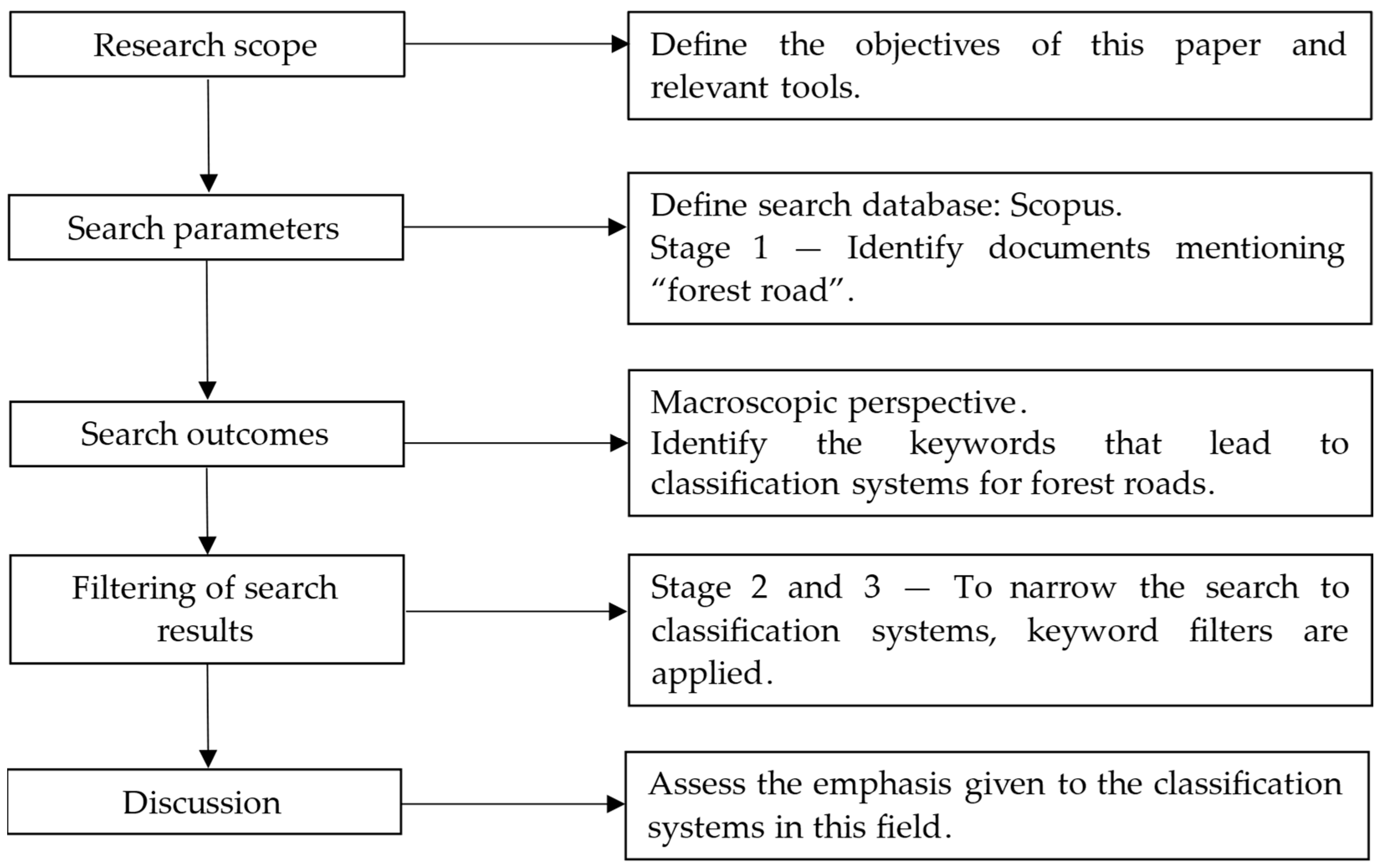
Given the difficulty in identifying exact keywords that would encompass every document associated with forest road classification systems, a different strategy was used. At first, all the information on the main subject of forest roads was gathered and analyzed. With the prospect of viewing the wide scope of information regarding forest roads, bibliometric tools were employed. To analyze the information collected, in addition to the tool for statistics from the Scopus database, when necessary, the bibliometric visualization software, VOSviewer 1.6.19, was used [12]. This tool serves as an intuitive software to create and visualize bibliometric information such as journals, researchers and publications using relationships such as citations, bibliographic coupling, co-authorship and co-citation.
Subsequently, keywords that could identify documents about classification systems were identified. Following the application of these filters, the results obtained were thoroughly examined to determine whether each document indeed referenced a classification system and, if so, in what context. From this analysis, a brief description of each document was made, allowing the characterization of the main topic approached. The representation of the strategy followed is presented in Figure 1.

Figure 1.
Methodology followed for the assessment of classification systems for forest roads.
3. Results
3.1. Overview of Results
The first assessment of information was performed using the same keywords in multiple databases. As the Scopus database had a higher number of results, it was chosen as the database to use for the review. The filters used for the search of documents by “title, abstract, keywords” using the Scopus database were initially chosen with the intention of assembling comprehensive information about forest roads from a macro perspective, for an overview of the spectrum of research on this topic.
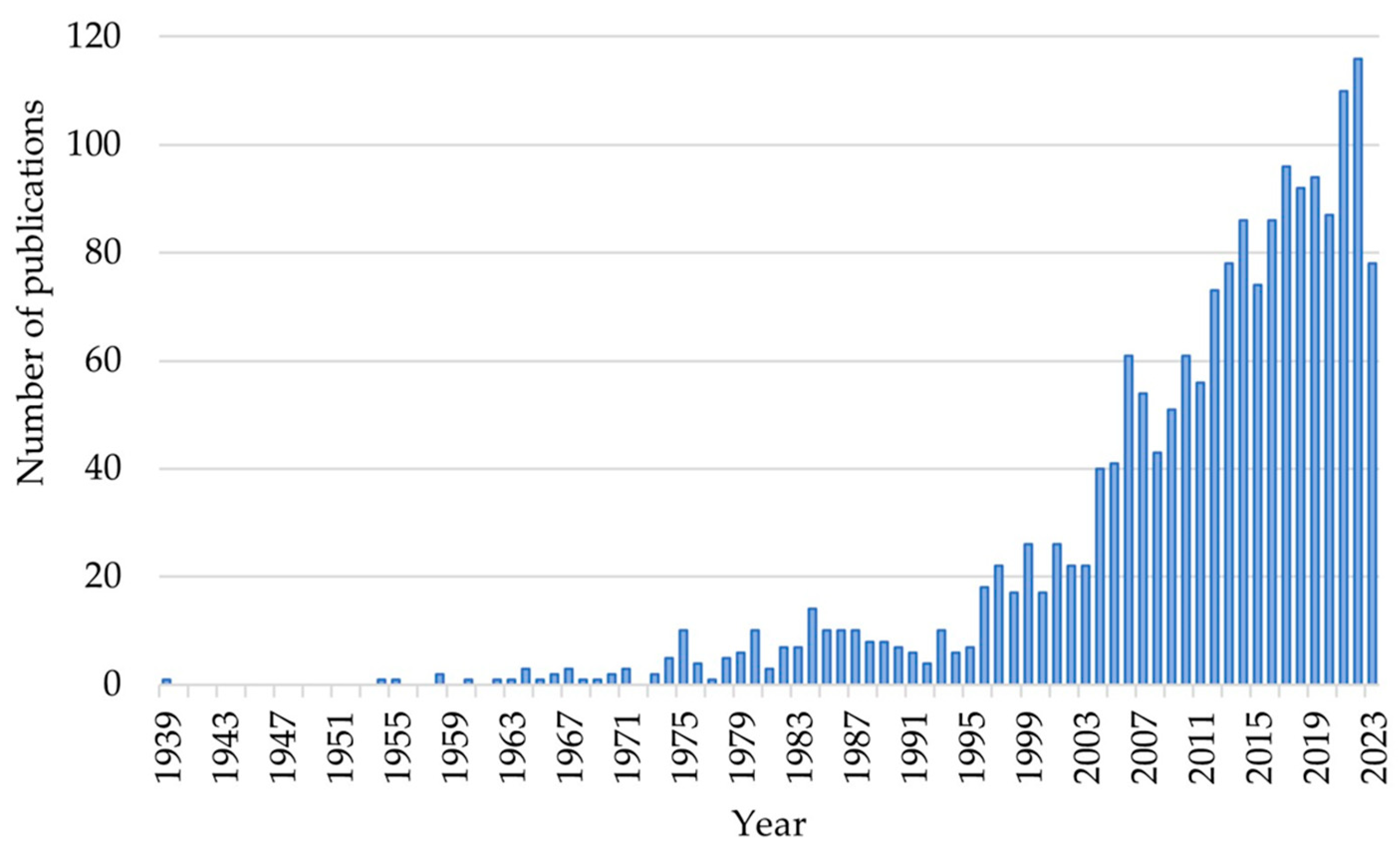
The aggregation of results on the Scopus search bar using the keyword “Forest Road*” (the symbol “*” is used in the Scopus database to search words derived from the base word, in this case plural form which is Forest roads) resulted in 1831 documents published between 1939 and 2023. The search was conducted on 9 October 2023, and no filters, such as document type, year of publication or language, were applied to the search. These initial results covered a broad spectrum of research topics and included a diverse range of studies, allowing the characterization of the subject trends.
Various types of documents were found in the results: 80% of the documents are articles; the remaining documents are mostly conference papers (around 14%). Therefore, most of the information collected comes from reliable (peer-reviewed) sources, such as scientific journals.
Assessing the number of publications per year, as shown in Figure 2, it is noticeable that between 1939 and 1995, the number of publications was less than 15 per year. However, in the early 2000s, a significant increase in publications regarding forest roads was registered.

Figure 2.
Number of publications on “Forest Road*” per year, adapted from Scopus (on 9 October 2023).
The result analysis allowed the conclusion that, based on the data from the Scopus database, the number of publications on forest roads has been actively increasing over the years. This upsurge can be justified by the use of the internet becoming more relevant in the field of investigation, increasing the number of researchers and publications on a digital level. Furthermore, there is currently a greater emphasis on developing innovative and efficient techniques that optimize resource and time management for logging and exploration activities.
With the objective of focusing on the information on classification systems, using the software VOSviewer, all keywords used were gathered directly from Scopus. The program algorithm creates clusters based on the similarity of the group of keywords from each document. In this way, it is possible to analyze the thematic connection between results. Using this tool, a visualization map was obtained, as shown in Figure 3. The software gathers all the keywords associated with the different documents and creates clusters based on the correlation between publications. Keywords from the same cluster share the same main topic. The analysis in VOSviewer collected a total of 4449 keywords; upon restriction to a minimum of five occurrences, 164 keywords were obtained, based on the schematic shown in Figure 3. The number of occurrences of each keyword is identified between brackets; the most used keywords are summarized in Table 1, to identify the theme from each cluster. The analysis returned up to 30 keywords for each cluster. From these results, the keywords that better distinguish clusters were selected, also considering the frequency of each keyword.
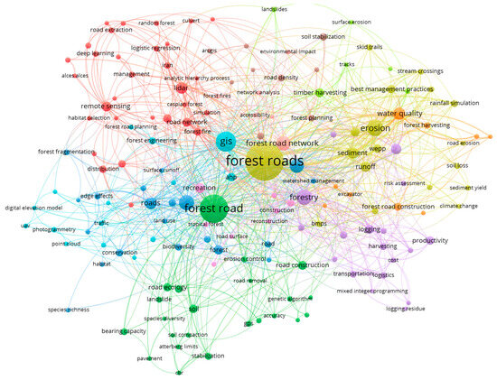
Figure 3.
Co-occurrence map of authors’ keywords, from VOSviewer (on 9 October 2023).

Table 1.
Keyword analysis presenting cluster distribution (number of occurrences of each keyword in brackets) (on 9 October 2023).
With this overview of the theme, it is possible to identify which keywords point to potential records approaching system classification for forest roads. Given that classification systems are a tool applied to the planning phase of forest roads, while analyzing the clusters, the ones that stood out regarding this information were clusters 8, 9 and 10 (Table 1).
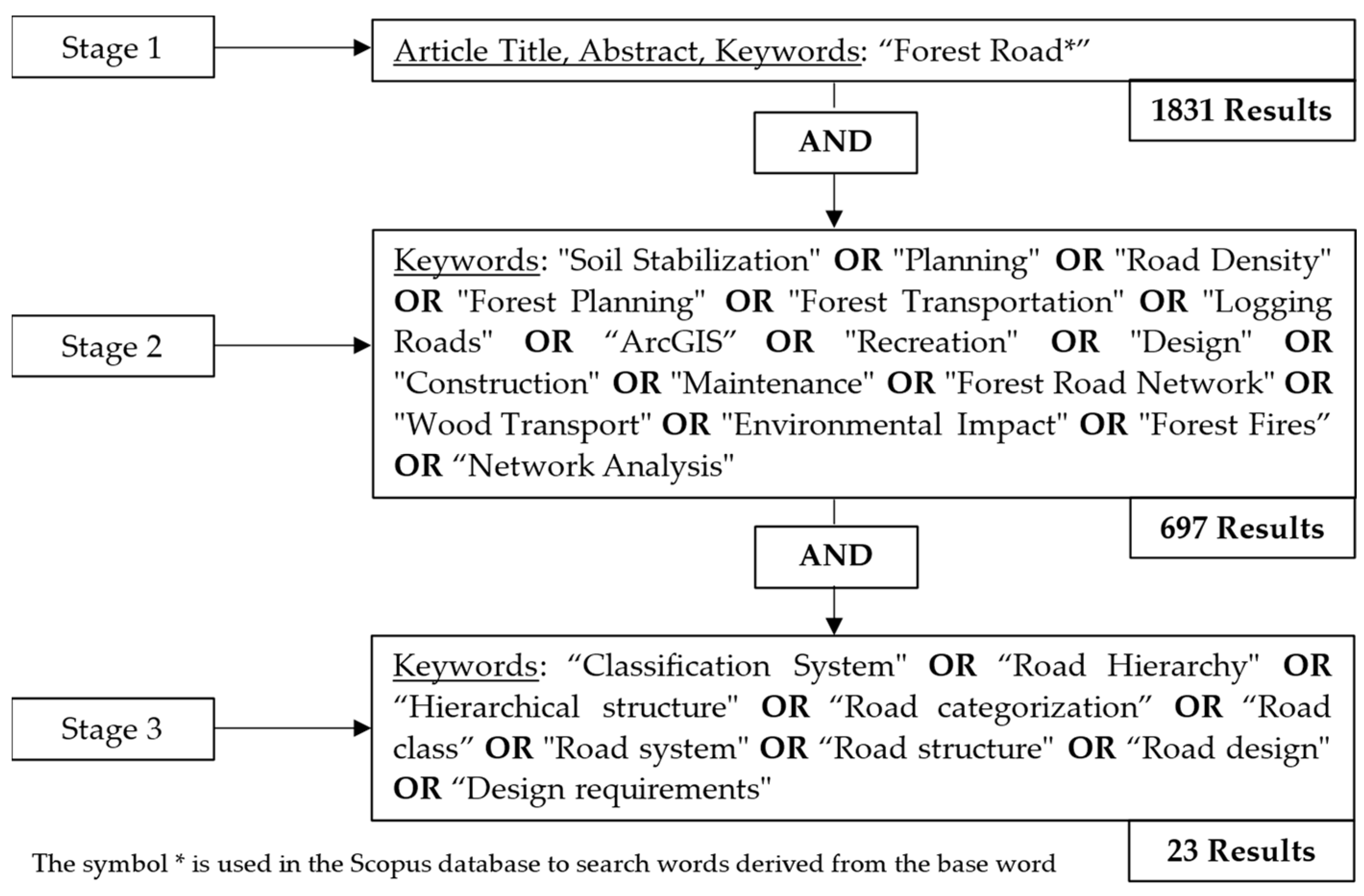
3.2. Result Refinement
The refinement of the results implemented is described in Figure 4. Given the main objective of identifying the search significance given to classification systems on this field, the chosen keyword clusters (8, 9 and 10 in Table 1) were applied, in Stage 1 (Figure 4). From this filtering, 697 results were obtained. Given the wide scope of results, a new stage of refinement was considered (Stages 2 and 3, Figure 4). To ensure the road classification topic is mentioned in each document that resulted from this filtering, new words were incorporated into the search. The filtering stages applied, on the Scopus search bar, in an attempt to gather relevant information, appear in Figure 4.
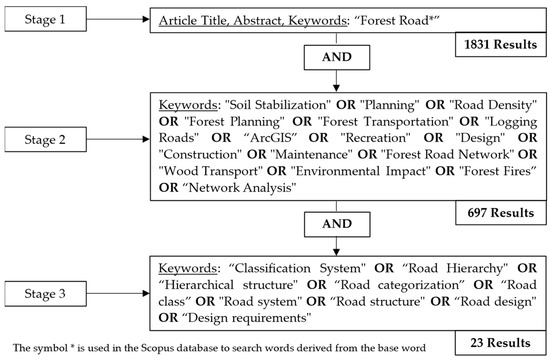
Figure 4.
Refinement of results: filtering stages of the search.
With these requirements, 23 results were obtained, representing approximately 1.3% of the results from the first analysis on the main topic. The documents identified from this filtering were mainly journal articles (78.3%); the remaining documents were conference papers (13.0%), book chapters (4.3%) and notes (4.3%). The assessment of each document helps determine the extent of the use of classification systems in studies of this area of research.
Reviewing the entire content of these documents allows the determination of whether any reference was made to classification systems for forest roads. From this full-content review, Table 2 was created to consolidate the information gathered (the order in which the documents are listed is based on their number of citations). Table 2 presents an overview of the content of each paper and highlights any mentions of classification systems.
Table 2.
Content analysis of results on classification systems, after the refinement of results described in Figure 4, by number of citations (on 9 October 2023).
4. Discussion
The review of the search results allowed identifying different topics of research. The majority of the reviewed documents consider some form of computer-based analysis, potentializing the decision-making process given by simulations that can be assessed before construction. This is the case of Akay and Sessions [13] and Akay [14], who consider TRACER and a forest optimization model to evaluate the best alignment solution in specific cases, aiming to minimize economic and environmental impacts. Genetic algorithms are also referred to as tools for comparing various solutions, aiming to enhance biodiversity, minimize soil loss [15] and reduce associated costs in forest road operations [33].
Accordingly, authors such as Akay [21], Hosseini et al. [27] and Farabi et al. [31] use other computer-based tools, namely linear programming, GIS and GIS with additional satellite data, to respectively optimize road alignments, assess land suitability for road network, and predict environmental impacts, such as soil erosion and stream water deterioration. Trench failure prediction is also studied by Jalali et al. [26], through three statistical models.
Also in this topic, various sources rely on digital elevation models (DEMs) to study different variables in the construction of forest roads and to optimize the road alignment. Aruga et al. [16] consider a light detection and ranging (LiDAR) that supports DEMs, ultimately assessing earthwork volumes from DEM-generated cross-sections. Aruga et al. [18] perform soil sediment evaluation based on high-resolution DEMs, rendering optimized solutions for road alignment.
The bearing capacity of forest road networks is explored and developed by Czerniak et al. [23] and Mușat et al. [33], who consider different road structure solutions using the finite element method to assess the response of the structure to different loads.
The environmental impacts of the construction of this type of road also hold relevance, as most authors study impacts such as soil erosion, sedimentation, leaching problems and habitat destruction.
Supporting sustainable practices, Lindroos et al. [24] and Skels et al. [25] evaluate the incorporation of fly ash, from the incineration of wood and peat, regarding the impacts on leaching of heavy metals, water quality and soil stabilization potential.
From the documents studied, only Keller et al. [28] consider a clear form of forest road classification. Keller et al. [28] analyze the content of the Amazon Basin Forest Roads Manual, which aims to develop standards and guidelines for forest road operations. This manual gives information on transportation planning, road design and road maintenance strategies and includes main issues such as slope stabilization, road deterioration, environmental and erosion.
In [28], the functional aspects of forest road classification are presented and divided into four classes. These classes were defined in accordance with the function they are expected to fulfill. Primary roads support higher traffic volumes and, therefore, must follow more/stricter design requirements to ensure capability throughout the period of use. The area that they serve is larger than the other types of roads and can be linked to the national road system. Secondary roads have less strict requirements, as the traffic volumes are minor and are only used in certain seasons. Temporary roads are developed to the minimum standard possible, allowing only log trucks for a limited period. Skid trails have the same design patterns and consist of cleared paths defined to only accommodate skidders in the organization of logs to be transported. The road surface uses organic materials that can promote revegetation after the periods of use.
In addition to this functional description, Keller et al. [28] define design requirements associated with each class, as summarized in Table 3. These requirements ensure that each road has the conditions to support the activities assigned to it, given the road class function.
Table 3.
Design standards of the classification system, adapted from Keller et al. [28].
Refining the search to find any mention of the use of classification systems for this type of road (Figure 4) primarily revealed that this topic does not hold significant prominence in the publications records analyzed. The scarce information on this topic reveals a significant gap in the existing research. It is worth noting that none of the documents focuses on the study or development of such systems, which would point to current developments. This determines that there is not in fact a current advance in this research field regarding the development or study of classification systems for forest roads. This lack of information potentiates the need for investment in this possible field of research.
While this topic is not on the trends of research on forest roads, it does not certainly indicate a total absence of information on the subject. As a potential source of information, forest road manuals [28] stand out, meaning this type of document can in fact incorporate classification systems. Questioning this argument, a focused research effort was undertaken on forest road manuals, involving the analysis of six design manuals (Table 4).
Table 4.
Search results focused on forest road manuals.
From the search, it was found that all documents included information on classification systems for forest roads. This outcome suggests that the subject under study may not be extensively covered in forest-related journals, as previously expected, but rather by institutions aiming to identify region-specific needs and develop corresponding systems accordingly.
The manuals presented are developed by governmental institutions aiming to provide detailed information to facilitate all tasks associated with the forest engineering process. This entails all planning, construction and maintenance. Regarding planning strategies, considering critical economic, environmental and safety aspects, these manuals consider that a key part of this process is the consideration of road specification. According to the expected level of use, certain requirements are defined, such as road width, maximum grade and curve radius. Additionally, considering the need to allow for non-standard vehicles, these road networks have to fulfill geometrical requirements different from standard information found in traditional road design manuals.
5. Conclusions
This paper presents a literature review conducted to examine publications related to forest roads, to ultimately filter and evaluate the information on the incorporation of classification systems in the planning strategies for forest roads. Using the Scopus database to gather publications, various data points were mapped, such as temporal distribution of publications, citation metrics, keyword inputs and other bibliometric markers.
This paper presents an overview of the publications on forest roads, a field in which there have been various developments, mostly after the 2000s. This reflects the growing recognition of the value given to forest road planning and strategizing. Further in the search, after restricting the scope of information on forest road classification systems through keyword filtering, the results were analyzed and compared.
The different shifts in theme allowed the characterization of the current concerns regarding this topic, such as the environmental impacts related to the response of the surrounding environment to the disturbance of the natural order. They also revealed the current interest in developing software to allow the prediction of potential outcomes, given predefined criteria. These shifts predispose the field’s adaptability and evolution to respond to the challenges of the present day.
The focus on classification systems shows that although this is not an area with extensive documentation in constant development, it is important to consider the analysis of this planning strategy. Classification systems present advantages in relation to the planning of these road networks, facilitating the decision-making process by incorporating predefined requirements of different types of roads, in relation to the function that they are expected to fulfill. For this specific topic, this review identified the need to analyze information from other non-scientific sources, such as government entities. The information found on these systems was presented, initially, from an overview of a forest road design manual. Focusing the research on these design manuals, six examples of manuals that consider classification systems for forest roads were collected. This aspect suggests that these development strategies may be discussed within more technical literature dedicated to forest road design. Future works could focus on detailing the information regarding this topic. This gap ultimately identifies a potential area of research and development, as the existing information may come from older sources and may need updating or reassessing. Collecting this information may help the development of more standardized and effective road planning strategies. As the world evolves and changes priorities, it becomes important to evaluate the techniques that can be used or adjusted to the necessities, paving the way for more efficient and environmentally aware planning strategies.
Author Contributions
Conceptualization, D.R. and J.M.; methodology, D.R. and J.M.; validation, D.R., J.M. and M.P.-L.; formal analysis, D.R. and J.M.; investigation, D.R.; resources, J.M. and M.P.-L.; data curation, D.R., J.M. and M.P.-L.; writing—original draft preparation, D.R.; writing—review and editing, D.R., J.M. and M.P.-L.; visualization, D.R., J.M. and M.P.-L.; supervision, J.M. and M.P.-L.; project administration, J.M. and M.P.-L.; funding acquisition, J.M. and M.P.-L. All authors have read and agreed to the published version of the manuscript.
Funding
This study was funded by the PRR—Recovery and Resilience Plan and by the NextGenerationEU funds at Universidade de Aveiro, through the scope of the Agenda for Business Innovation “Transform—Transformação digital do setor florestal para uma economia resiliente e hipocarbónica” (Project No. 34 with the application C644865735-00000007). FCT (“Fundação para a Ciência e a Tecnologia”, Portugal) is acknowledged through the project UIDB/04450/2020 (RISCO). 
Institutional Review Board Statement
Not applicable.
Informed Consent Statement
Not applicable.
Conflicts of Interest
The authors declare no conflicts of interest. The funders had no role in the design of the study; in the collection, analyses or interpretation of data; in the writing of the manuscript; or in the decision to publish the results.
References
- Eurostat. Agriculture, Forestry and Fishery Statistics; Statistical Book; 2020; Available online: https://ec.europa.eu/eurostat/web/products-statistical-books/-/ks-fk-20-001 (accessed on 2 November 2023).
- Gumus, S.; Hatay, T.Y.; Ünver, S. An Evaluation of General Situation and Importance of Forest Roads: Turkish Forestry. In Proceedings of the 2nd International Symposium of Forest Engineering and Technologies, Tirana, Albania, 4–6 September 2019. [Google Scholar]
- Çalışkan, E. Geographic Information System (GIS) and Roadeng Usage to Determine the Environmentally Sensitive Forest Road Route in Mountainous Terrain. Eur. J. Interdiscip. Stud. 2016, 2, 18–25. [Google Scholar] [CrossRef]
- Hayati, E.; Majnounian, B.; Abdi, E. Qualitative evaluation and optimization of forest road network to minimize total costs and environmental impacts. iForest 2012, 5, 121–125. [Google Scholar] [CrossRef]
- Thompson, M.P.; Gannon, B.M.; Caggiano, M.D. Forest roads and operational wildfire response planning. Forests 2021, 12, 110. [Google Scholar] [CrossRef]
- Mousavi, F.; Abdi, E.; Borz, S.A. Forest Road Subgrade Improvement by Lime and Sodium Nanoalginate Used as Stabilizers for Clay Soils. Forests 2023, 14, 1332. [Google Scholar] [CrossRef]
- Decreto-Lei n. 222/98 de 17 de Julho Pelo Ministério do Equipamento, do Planeamento e da Administração do Território. 1998, pp. 3444–3454. Available online: https://diariodarepublica.pt/dr/detalhe/decreto-lei/222-1998-424689 (accessed on 15 November 2023). (In Portuguese).
- Eppell, V.; McClurg, B.; Bunker, J. A four level road hierarchy for network planning and management. In Proceedings of the 20th ARRB Conference, Melbourne, VIC, Australia, 19–21 March 2001; pp. 1–7. [Google Scholar]
- Instituto da Mobilidade e dos Transportes, “Rede Viária—Princípios de Planeamento e Desenho. Available online: https://www.imt-ip.pt/sites/IMTT/Portugues/InfraestruturasRodoviarias/RedeRodoviaria/Paginas/PlanoRodoviarioNacional.aspx (accessed on 23 January 2024). (In Portuguese).
- Shi, Y.; Wang, Z.; Zhang, G.; Wei, X.; Ma, W.; Yu, H. Evaluating the Research Status of the Remote Sensing-Mediated Monitoring of Forest Biomass: A Bibliometric Analysis of WOS. Forests 2024, 15, 524. [Google Scholar] [CrossRef]
- Xie, J.; Zhang, G.; Li, Y.; Yan, X.; Zang, L.; Liu, Q.; Chen, D.; Sui, M.; He, Y. A Bibliometric Analysis of Forest Gap Research during 1980–2021. Sustainability 2023, 15, 1994. [Google Scholar] [CrossRef]
- Van Eck, N.J.; Waltman, L. Software survey: VOSviewer, a computer program for bibliometric mapping. Scientometrics 2010, 84, 523–538. [Google Scholar] [CrossRef]
- Akay, A.E.; Sessions, J. Applying the decision support system, TRACER, to forest road design. West. J. Appl. For. 2005, 20, 184–191. [Google Scholar] [CrossRef]
- Akay, A.E. Minimizing total costs of forest roads with computer-aided design model. Sadhana Acad. Proc. Eng. Sci. 2006, 31, 621–633. [Google Scholar] [CrossRef]
- Aruga, K.; Sessions, J.; Akay, A.E. Heuristic planning techniques applied to forest road pro-files. J. For. Res. 2005, 10, 83–92. [Google Scholar] [CrossRef]
- Aruga, K.; Sessions, J.; Akay, A.E. Application of an airborne laser scanner to forest road design with accurate earthwork volumes. J. For. Res. 2005, 10, 113–123. [Google Scholar] [CrossRef]
- Contreras, M.; Aracena, P.; Chung, W. Improving accuracy in earthwork volume estimation for proposed forest roads using a high-resolution digital elevation model. Croat. J. For. Eng. 2012, 33, 125–142. [Google Scholar]
- Aruga, K.; Sessions, J.; Miyata, E.S. Forest road design with soil sediment evaluation using a high-resolution DEM. J. For. Res. 2005, 10, 471–479. [Google Scholar] [CrossRef]
- Heralt, L. Using the ROADENG system to design an optimum forest road variant aimed at the minimization of negative impacts on the natural environment. J. Sci. 2002, 48, 361–365. [Google Scholar] [CrossRef]
- Saito, M.; Goshima, M.; Aruga, K.; Matsue, K.; Shuin, Y.; Tasaka, T. Study of automatic forest road design model considering shallow landslides with lidar data of funyu experimental forest. Croat. J. For. Eng. 2013, 34, 1–16. [Google Scholar]
- Akay, A.E. A new method of designing forest roads. Turk. J. Agric. For. 2004, 28, 273–279. [Google Scholar]
- Vanhanen, H.; Dahl, O.; Joensuu, S. Utilization of wood ash as a road construction material-sustainable use of wood ashes. Sustain. Environ. Res. 2014, 24, 457–465. [Google Scholar]
- Czerniak, A.; Grajewski, S.M.; Kurowska, E.E. Bearing capacity standards for forest roads constructed using various technologies from mechanically and chemically stabilised aggregate. Croat. J. For. Eng. 2021, 42, 477–489. [Google Scholar] [CrossRef]
- Lindroos, A.J.; Ryhti, K.; Kaakkurivaara, T.; Uusitalo, J.; Helmisaari, H.S. Leaching of heavy metals and barium from forest roads reinforced with fly ash. Silva Fenn. 2019, 53, 10088. [Google Scholar] [CrossRef]
- Skels, P.; Bondars, K.; Haritonovs, V. Wood fly ash stabilization of unbound pavement layers. In Proceedings of the ICSMGE 2017—19th International Conference on Soil Mechanics and Geotechnical Engineering, 19th ICSMGE Secretariat, Seoul, Republic of Korea, 17–22 September 2017; pp. 513–516. [Google Scholar]
- Jalali, A.M.; Naghdi, R.; Ghajar, I. Potential Evaluation of Forest Road Trench Failure in a Mountainous Forest, Northern Iran. Croat. J. For. Eng. 2022, 43, 169–184. [Google Scholar] [CrossRef]
- Hosseini, S.A.O.; Moghadasi, P.; Fallah, A. Forest road network design based on multipurpose forestry management in hyrcanian forest. J. Environ. Sci. Manag. 2019, 22, 13–20. [Google Scholar] [CrossRef]
- Keller, G.; Sherar, J.; Zweede, J. Overview of Amazon Basin Forest Roads Manual. Transp. Res. Rec. 2015, 2472, 56–63. [Google Scholar] [CrossRef]
- Slincu, C.; Ciobanu, V.; Dumitrascu, A.E. Risks assessment in forest roads design. Bulletin of the Transilvania University of Brasov, Series II: Forestry, Wood Industry. Agric. Food Eng. 2012, 5, 43–48. [Google Scholar]
- Aricak, B.; Wing, M.G.; Akay, A.E. State of the Art on Airborne LiDAR Applications in the Field of Forest Engineering. Concepts and Applications of Remote Sensing in Forestry; Springer Nature: Berlin/Heidelberg, Germany, 2023; pp. 357–369. [Google Scholar] [CrossRef]
- Farabi, H.; James, R. Using GIS, terrain attributes and hydrologic models to predict the risk of soil erosion and stream water deterioration caused by forest roads. In Proceedings of the MODSIM05—International Congress on Modelling and Simulation: Advances and Applications for Management and Decision Making Proceedings, Sydney, Australia, 12–15 December 2005; pp. 2672–2678. [Google Scholar]
- Elliot, W.J.; Lewis, S.A.; Cannard, C.L. Measuring and modelling impacts of gravel road design on sediment generation in the southeastern U.S. J. ASABE 2023, 66, 1229–1254. [Google Scholar] [CrossRef]
- Mușat, E.C.; Bitir, I. Evaluating the Forest Road Systems Subjected to Different Loadings by Using the Finite Element Method. Forests 2022, 13, 1872. [Google Scholar] [CrossRef]
- Kim, S.-w.; Piao, Z.; Lee, D.-K. Optimal road design using genetic algorithm to improve biodiversity and risk of soil loss. Geocarto Int. 2022, 37, 14811–14827. [Google Scholar] [CrossRef]
- Grace, J.M. Determining the range of acceptable forest road erosion. In American Society of Agricultural and Biological Engineers Annual International Meeting; ASABE: St. Joseph, MI, USA, 2008; Volume 5, pp. 2826–2836. [Google Scholar] [CrossRef]
- Food and Agricultural Organization of the United Nations. Planning Forest Roads and Harvesting Systems; FAO: Rome, Italy, 1977. [Google Scholar]
- State Forests of New South Wales. Forest Roads and Fire Trails; State Forests of NSW: Sydney, Australia, 1999. [Google Scholar]
- Ministère des Forêts de la Faune et des Parcs. Forest Road Engineering Guidebook; British Columbia. 2002. Available online: https://www2.gov.bc.ca/assets/gov/environment/natural-resource-stewardship/land-based-investment/forests-for-tomorrow/fre.pdf (accessed on 16 November 2023)(In Française).
- Minnesota Department of Natural Resources. Forest Classification & Forest Road & Trail Designations for State Forest Lands in Lake County, Minnesota, 2007. Available online: https://files.dnr.state.mn.us/input/mgmtplans/ohv/designation/finland_lakeplan.pdf (accessed on 16 November 2023).
- Austroads. Guide to Pavement Technology Part 6: Unsealed Pavements; Austroads Ltd.: Sydney, Australia, 2009; Available online: https://austroads.com.au/publications/pavement/agpt06 (accessed on 16 November 2023).
- Gilmore, B.; Mackie, G.; Meredith, K. New Zealand Forest Road Engineering Manual; Forest Owners Association: Wellington, New Zealand, 2020; ISBN 978-0-473-50661-2. Available online: https://www.nzfoa.org.nz/resources/publications (accessed on 16 November 2023).

Disclaimer/Publisher’s Note: The statements, opinions and data contained in all publications are solely those of the individual author(s) and contributor(s) and not of MDPI and/or the editor(s). MDPI and/or the editor(s) disclaim responsibility for any injury to people or property resulting from any ideas, methods, instructions or products referred to in the content. |
© 2024 by the authors. Licensee MDPI, Basel, Switzerland. This article is an open access article distributed under the terms and conditions of the Creative Commons Attribution (CC BY) license (https://creativecommons.org/licenses/by/4.0/).