Article

Spatial Distribution of Forest Soil Base Elements (Ca, Mg and K): A Regression Kriging Prediction for Czechia

by
Vincent Yaw Oppong Sarkodie
1,
Radim Vašát
1,
Karel Němeček
1,
Vít Šrámek
2,
Věra Fadrhonsová
2,
Kateřina Neudertová Hellebrandová
2,
Luboš Borůvka
1 and
Lenka Pavlů
1,*
1
Department of Soil Science and Soil Protection, Faculty of Agrobiology, Food and Natural Resources, Czech University of Life Sciences Prague, Kamýcká 129, 165 00 Prague, Czech Republic
2
Forestry and Game Management Research Institute, Strnady 136, 252 02 Jíloviště, Czech Republic
*
Author to whom correspondence should be addressed.
Forests 2024, 15(7), 1123; https://doi.org/10.3390/f15071123
Submission received: 6 May 2024 / Revised: 21 June 2024 / Accepted: 22 June 2024 / Published: 28 June 2024
(This article belongs to the Special Issue Monitoring and Modelling of Soil Properties in Forest Ecosystems)

Abstract

:
Base cations have declined within European forests due to leaching, accelerated by atmospheric acid deposition. This study aims at predicting the spatial distribution of pseudototal content of Ca, Mg, and K for coniferous, broadleaved and mixed forest stands. A harmonised database of about 7000 samples from the top mineral layer of 0–30 cm from the entire forest areas of the Czech Republic was used. A regression kriging model was used for spatial prediction of the content of the elements. The influence of the covariates used for the prediction was assessed using generalized additive models for location scale and shape (GAMLSS). The variance explained by the model was best for Ca with the R2 of 0.32, the R2 for Mg was 0.30, and the R2 for K was 0.26. Model fitting assessed by the ratio of performance to inter-quartile distance (RPIQ) showed K as the best fit with a value of 1.12, followed by Mg with the value 0.87, and Ca with 0.25. Ca exhibited the best prediction fit for the GAMLSS, compared with K and Mg, based on their AIC matrix values. The predicted spatial distribution in this study provides information for policy and will provide information for the sustainable management of forests.

1. Introduction

Atmospheric acid deposition on European forest soils during the second half of the 20th century [1,2,3] made the topsoil of forests acidic with declining base cations, thus affecting the vitality of trees, soil biodiversity, and the general functioning of the forest soil ecosystem [4,5,6]. Precipitation on the litter and soils within coniferous forest stands increases further losses of base cations through leaching [7]. Broadleaf forests are less likely to be acidic. Their growth, compared to conifers, is slow and their exchangeable base cation pools are higher compared to conifers [8]. The natural distribution of tree species and how these tree species are mixed within forests is influenced by climate and soil type [9]. However, the distribution of different types of forest was significantly changed by humans, leading to a much higher proportion of the coniferous forest compared to the natural proportion.
Mineral weathering is a significant source of base cations that replenish losses within soil to neutralize acid soils [10]. An important requirement for a healthy soil is the bioavailability of base cations. The sustainable exploitation of base cations is driven by knowledge of their sources within forest soils [11]. Several studies have focused on concentrations of base cations (Ca, Mg, and K) within forest areas known to have been severely affected by the atmospheric acid deposition and superficial humus removal. Findings from these studies observed low base cation concentrations [12,13], resulting from leaching [14]. Liming has been applied on some severely affected forest soils to improve their base cation concentrations [1]. Forest areas that are not severely affected by the acid deposition may not have received enough attention regarding their base cation concentration and/or distribution. The objective of this study was to predict the pseudototal concentration of base elements across the entire forest areas of the Czech Republic. Our focus is on the three main forest types, i.e., coniferous, deciduous and mixed forest stands. We pay attention to the influence of stand altitude, soil type and soil variability on spatial distribution of the predicted base elements (Ca, Mg, and K) concentrations within the mineral soils (0–30 cm).

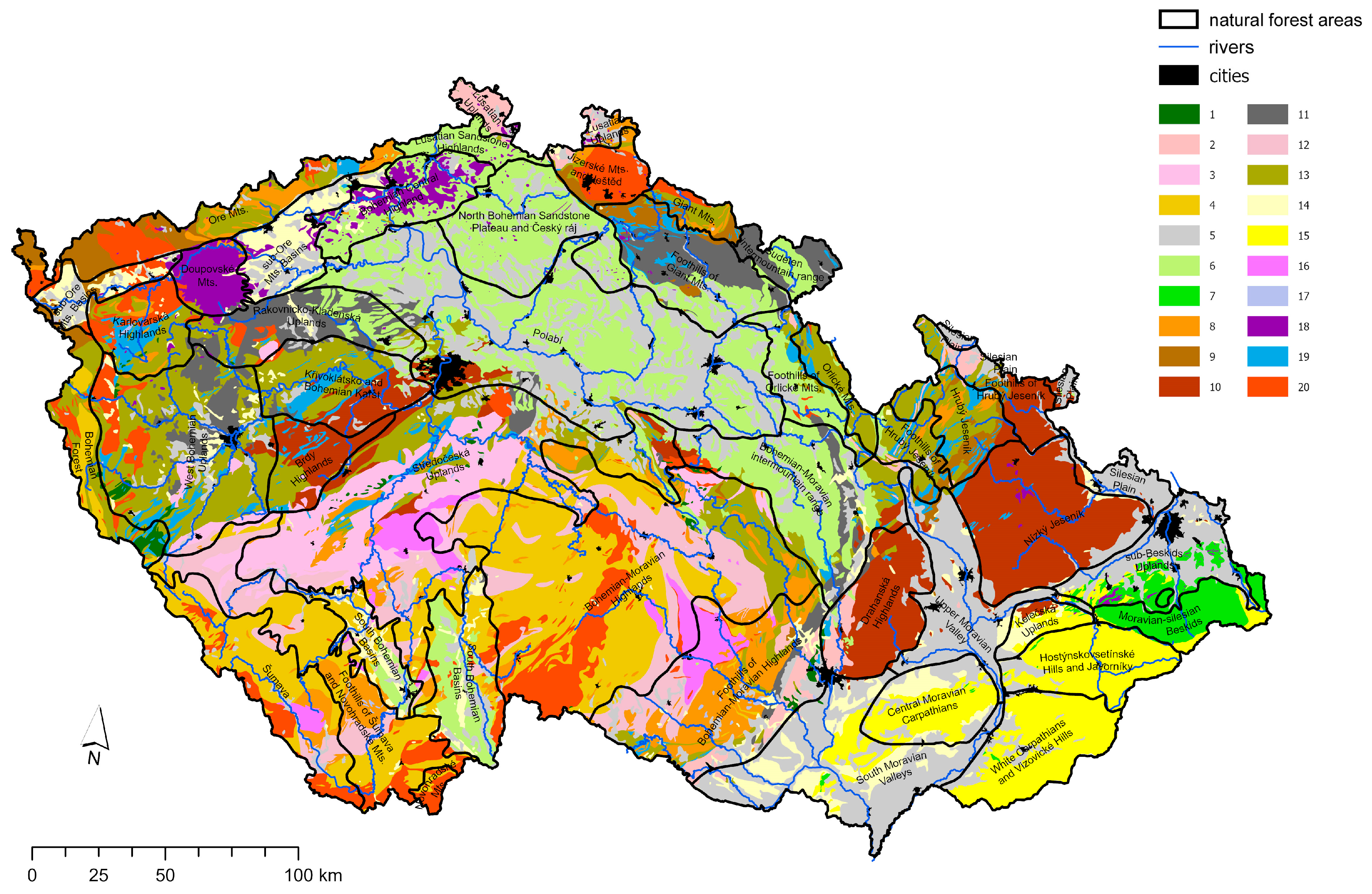
2. Materials and Methods

This study is conducted within the forest areas of the Czech Republic, a temperate broad-leaved deciduous forest zone of central Europe. The altitude of the study area ranges from 115 m to 1602 m above sea level. The geology of the forest areas (Figure 1) impacts their vegetation and soil. The vegetation is also influenced by human activities, and past bio-geographical processes [15,16]. The climate is described as temperate oceanic through temperate continental [17], with continental climate increasing from west towards east and down lowlands from the mountains. The average annual temperatures range from 1 to 10 °C. Annual precipitation ranges between 400 and 1400 mm. The month of July has the highest temperatures and rainfall records (https://www.chmi.cz (accessed on 1 April 2024); [18]). The forests cover an area of 2923.2 thousand hectares, which constitutes 37.1% of the entire land area of the Czech Republic [19]. Based on similarities in growing conditions, geology, climate, relief, and so on, the country is categorized into forty-one rather homogeneous natural forest areas [20]. The divisions of the forest areas are shown in Figure 1. Ref. Cambisols [21] form the biggest part of the soils in the country, forming almost 60% of the soils under the forest. This is followed by Podzols (approximately 25%), and much smaller portions of the forest areas are found with Fluvisols, Gleysols, Histosols, Leptosols, Luvisols, Retisols, and Stagnosols etc. [22].
The aggregated forest soil database was compiled from data collected by several institutions (Forest Management Institute, Central Institute for Supervising and Testing in Agriculture, Forestry and Game Management Research Institute and the Czech University of Life Sciences Prague) between the years 2000 and 2021 across the entire forest area of the Czech Republic [23]. The distribution of sampling sites was not completely even. Forest soil monitoring carried out by the Central Institute for Supervising and Testing in Agriculture focused primarily on the forest areas affected by the historic atmospheric acid deposition. This sampling approach thus favored forest areas on the mountainous parts of the country [23]. This study focused on base elements (Ca, Mg, and K) in the mineral topsoil (0–30 cm) layer, without the organic layers of the forest soil. The pseudototal content of the elements was analyzed by the aqua regia digestion [24]. In total, data on 7622, 7757 and 7753 locations were available for Ca, Mg and K, respectively.
The regression kriging modeling (random forest-kriging) and Generalized Additive Models for Location Scale and Shape (GAMLSS) are employed in this study for the distribution predictions, and significance assessment of the covariates to the base cations. The regression kriging modeling in our study involved an imposition of the random forest regression model to predict the spatial variability for each of the base elements across the forest areas, and a subsequent kriging of the regression residuals for their spatial interpolation [25,26,27,28,29]. This digital soil mapping (DSM) method is known to improve the accuracy in the prediction of soil properties [28,30]. GAMLSS compared the predictor influence on the elements [31].
All statistics and digital soil maps were prepared using machine learning algorithms and R packages in R Studio [32]. The environmental covariates: altitude, forest type, and soil classification, for the spatial prediction models were extracted from the digital elevation model (DEM) ArcČR® 500 with resolution of 200 m [33], CORINE Land Cover 2018 [34], and Soil Information System PUGIS at the resolution 1:250,000 [35], respectively. The forest typology maps of the Czech Republic provided forest stand data on the edaphic categories at a 1:10,000 scale [36,37]. The pedodiversity spatial pattern (PSP) at 50 m grid was also considered as a covariate for this study [38]. The prediction maps were developed with a grid of 500 m × 500 m over the entire forest areas of the Czech Republic. All maps in this study were prepared in ArcGIS Pro [39]. The choice of predictors was informed by our expert opinion on their influence on the soil properties under consideration. To validate the random forest-kriging model, the data for each of the soil base elements were split to 70% of the data for model training and 30% for validating the prediction. The index of determination (R2) and ratio of performance to inter quartile distance (RPIQ) were metrics used to validate the performance of the random forest-kriging model.

3. Results

3.1. Descriptive Statistics

The average pseudototal Ca, Mg, and K contents from the collated data were 754, 1990, and 1045 mg/kg, respectively. These observed mean values, however, yielded from varying numbers of samples. Mg had the highest number of samples, and the least sample number was observed for Ca with their respective sample numbers indicated also in the data sources subsection of the materials and method of this study. In their concentration comparisons, Ca had the least minimum observed concentration (3.5 mg/kg), whereas K had the highest maximum concentration value of 10,982 mg/kg observed (Table 1).

3.2. Generalized Additive Models for Location Scale and Shape (GAMLSS) for Base Elements and Their Predictors

We employed the GAMLSS model which works well for skewed and/or kurtotic continuous and discrete distributions [31] to assess the effects of the predictors on the base elements in focus (Table 2). The intercept for all the base elements were significantly different from a baseline concentration of zero. We observed significant effects of altitude and soil type on Ca, and a marginal significant effect of PSP at 4000 m in the element Ca. There are marginal effects of soil type and PSP4000m on Mg, whereas none of the predictors significantly effects K.

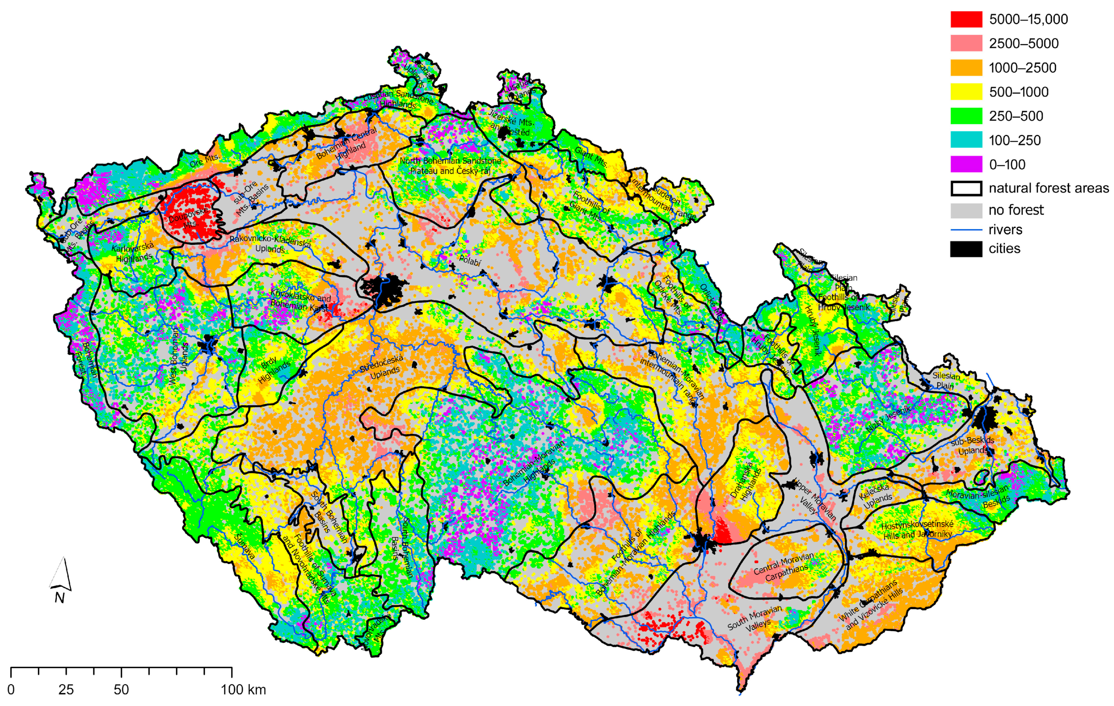
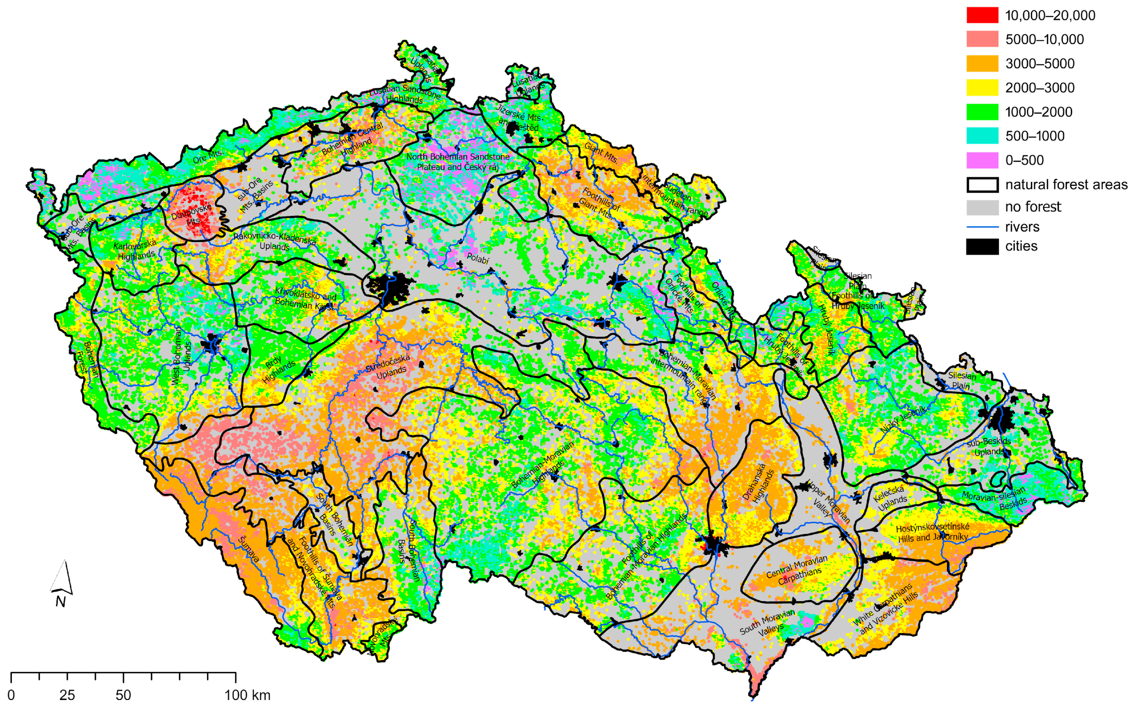
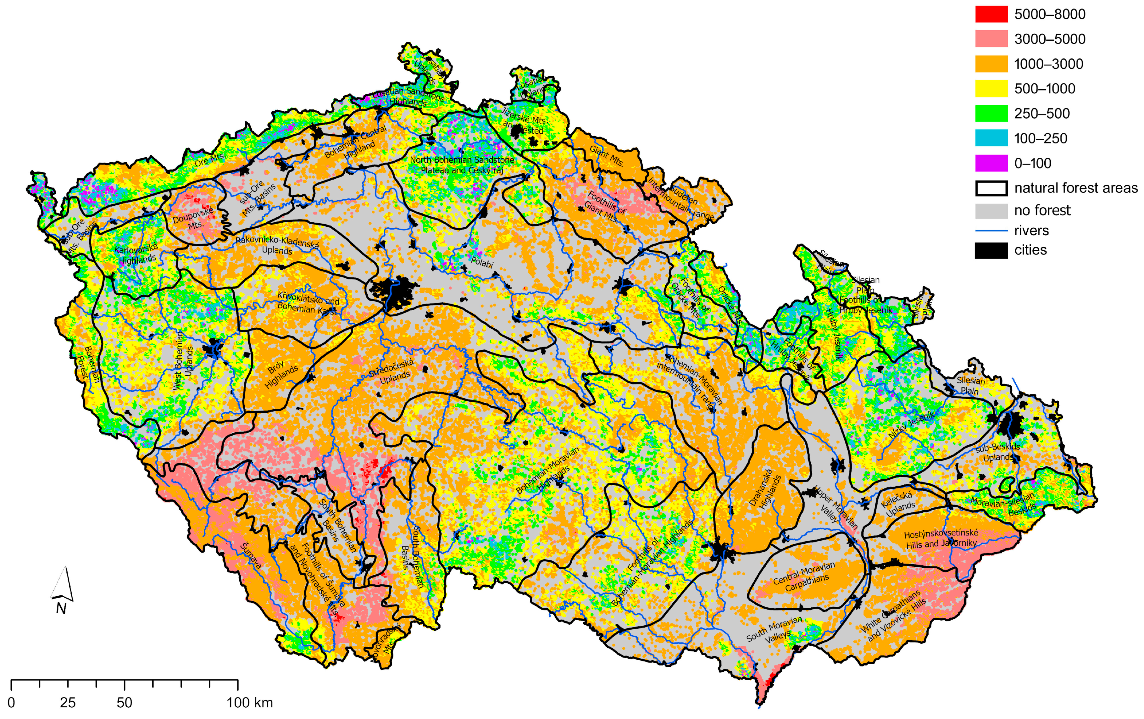
3.3. Predicted Maps of Elements

The borders of natural forest areas in the legend are indicated as natural forest areas. The maps are masked to show prediction values for areas with forest cover only. This is done to allow easy readability, and to avoid extrapolation to other areas. However, non-forest vegetational areas, indicated as no data on the maps, are colored in a gray color.
The highest predicted values of Ca are observed in Doupovské Mts., Drahanská Highlands, South Moravian Valleys and, Křivoklátsko and Bohemian Karst. Low predicted values for Ca are observed in Bohemian-Moravian Highlands, Křivoklátsko and Bohemian Karst, Nízký Jeseník, Moravian-silesian Beskids, North Bohemian Sandstone Plateau and Český ráj, Lusatian Uplands and also along the north-western border forest areas of Ore Mts., and sub-Ore Mts. Basins moving towards Bohemian Forest (Figure 2).
The Mg prediction showed Doupovské Mts. as noticeable for the highest predicted values, whilst the second highest predicted values were observed in areas of Středočeská Uplands, Foothills of Šumava and Novohradské Mts., Šumava, South Moravian Valleys, Central Moravian Carpathians and Bohemian Central Highlands. The forest areas with lower predicted Mg values were the north-western border of Ore Mts. Lusatian Sandstone Highlands and Polabí (Figure 3).
The highest prediction values for K were spotted within the second highest predicted K values in Středočeská Uplands, Foothills of Šumava and Novohradské Mts., South Moravian Valleys and Doupovské Mts. The Šumava and Hostýnskovsetínské Hills and Javorníky forest areas were also observed with high values predicted for K. The lower predicted values were observed in the northwestern border of Ore Mts., Lusatian Sandstone Highlands, North Bohemian Sandstone Plateau and Český ráj and Nízký Jeseník (Figure 4).
Table 3 shows the model validation metrics for the imposed random forest regression and the subsequent kriging of their residuals. We compared R2 for the random forest (RF) regression on the validation data to R2 from the final regression-kriging model. R2 for RF yielded 0.18 for Ca, 0.17 for Mg, and 0.22 for K. The R2 for random forest-kriging yielded 0.32 for Ca and 0.30 for Mg, and the R2 for K was 0.26. These R2 results show improvement in the explained variance in the random forest-kriging compared to RF alone. For the model fit test, as explained by the ratio of performance to inter quartile distance (RPIQ), the spatial distribution map for K yielded 1.12. This is followed by Mg with a value of 0.87, and Ca whose RPIQ value was 0.25 (Table 3).

4. Discussion

Takoutsing and Heuvelink [40] observed that the regression-kriging model outperforms RF. They further argued that the random forest-kriging had a higher model efficiency. Focusing on validation for the prediction maps of the base elements, their R2 showed that the variance explained by the predictors in Ca was the best, and this is followed by Mg, and K was explained the least. Higher R2 and RPIQ values for a model indicates a better explanation and model fit, respectively [41,42]. Digital soil maps predicted at country and continental scales (for example [43,44]) have been often found with low R2 values. Although K was the least explained by the predictors, it had the best model fit.
The GAMLSS model’s goodness-of-fit measured by AIC for Ca was 4655.62, 5332.12 for Mg, and 4747.17 for K. The model fit for Ca was the best as it had the low AIC value [31]. These results are just adequate, and thus suggest the need for further studies into the effects of these predictors on the base elements. Results from the analysis showed an influence of altitude, soil type and pedodiversity spatial pattern on Ca. Mg is influenced marginally by soil type and pedodiversity spatial pattern at 4000 m, whereas none of the predictors were observed to influence K.
We observed consistency in the highest predicted values for all three elements in the Doupovské Mts. The lowest predicted values for all the elements were also observed for the northwestern border of Ore Mts., and Lusatian Sandstone Highlands. Although the sampling approach for the dataset was not normally distributed, we could infer from observed factors such as geology and the historical exploitation of these forest areas for the distribution trends. Djodjic et al. [45] found geology to have influenced soil properties and nutrient concentrations. For example, Doupovské Mts. is in a region of the volcanic complex of the Bohemian massif where basaltic rocks dominate [15,46]. Basalts are rich in Ca and Mg [47]. The forest areas within the Moravia Region of the Czech Republic, such as South Moravian Valleys, Moravian-silesian Beskids and Hostýnskovsetínské Hills and Javorníky have alluvial soils and flysch [15]. Flysch is a bedrock of weakly and strongly weathered sandstones, clays and marls [48,49]. They have alternating layers of water-permeable sandstone and impervious claystone of cretaceous to lower tertiary age [15], and alluvial soils have higher concentrations of base cations, as was observed in a study by Victoria et al. [50]. In reference to historic times, the forest areas Foothills of Šumava and Novohradské Mts., South Bohemian Basins, through Středočeská Uplands had numerous artificial ponds. Some of these pond lands have now been converted into forest and agricultural lands. The concentration distribution of K and Mg in this zone, for example, may have been influenced by deposits accumulated in the converted pond lands. The agricultural use of lands in this zone may also have contributed to the spatial distribution of K concentrations within the zone. A specific case is the karst regions with limestone bedrock, where the Ca content is naturally high. This is the case of Moravian Karst (south of Drahanská Highlands) and Bohemian Karst, a region south-west from Prague in Central Bohemia [51]. Another factor that could account for the lower predicted base element values, especially along the north-western border of Ore Mts., and Lusatian Sandstone Highlands is the historic acid depositions. These areas are part of the high-altitude forest areas which observed the highest acid depositions in the second half of the 20th century [1].
In an earlier study of Ca, Mg, and K concentrations of alluvial soils of the Czech Republic, Chuman et al. [52] observed that base cations in these soils were influenced by topography and parent materials. Johnson [53] observed that weathering of parent materials had an influence on the Ca and Mg concentrations. Our results from the predictor influence on Ca, Mg and K revealed a significant influence on soil type, altitude and pedodiversity spatial pattern at 4000 m. Marginal influence of soil type and pedodiversity spatial pattern at 4000 m was also observed for Mg. We infer that this agrees with the observation than parent material, which informs the different soil types, has an influence on Ca and Mg.
Nutrient availability in forest soils is an important factor to be considered in accounting for the forest’s capacity to sequester and balance carbon [54,55]. Base cation leaching caused by high precipitation, acid forest tree (particularly coniferous) litter, and atmospheric deposition of acids in the forest areas have a significant influence on forest soil nutrient availability [56]. The predicted spatial distribution of base elements (Ca, Mg and K) could be interpreted using background information (geology and the historical exploitation) on the forest areas. Background information and nutrient dynamics are useful for accurate predictions of the interactions within forest environments [57]. Mineral weathering supplies lost base cations to forest soils [58]. An increase in base cations from weathering is predicted to have a positive influence on climate change [59].

5. Conclusions

Soil type and pedodiversity spatial pattern as predictors have an influence on Ca and Mg distribution within the forest areas. Ca showed the best fit model for the Generalized additive models for location scale and shape (GAMLSS), based on the AIC values.
The random forest-kriging model showed an improvement in R2 compared to the random forest regression model alone. The prediction fit for the random forest-kriging using the RPIQ matrix showed a decreasing trend of K > Mg > Ca. However, the R2 matrix used for the variability explained by the prediction showed Ca as the best compared to Mg and K for the forest areas.
Doupovské Mts. showed the highest predicted values for all three elements. The lowest predicted values for all the elements were observed in the north-western border of Ore Mts., and Lusatian Sandstone Highlands.
With an uneven sampling from the different institutions who contributed to the database used in this study, our recommendation is that future studies consider sampling with a focus on assessing the influence of geology and anthropogenic activities on the distribution of base elements, both available and total content, within the entire forest areas.

Author Contributions

Conceptualization, V.Y.O.S. and L.B.; methodology, V.Y.O.S. and L.B.; formal analysis, V.Y.O.S. and R.V.; investigation, R.V., V.Š., V.F. and K.N.H.; resources, L.B. and L.P.; data curation, V.Y.O.S.; writing—original draft preparation, V.Y.O.S.; writing—review and editing, V.Y.O.S., L.B. and L.P.; visualization, K.N., V.Y.O.S. and R.V.; supervision, L.B. and L.P.; project administration, L.B.; funding acquisition, L.B. All authors have read and agreed to the published version of the manuscript.

Funding

This research was funded by Technology Agency of the Czech Republic, project No. SS06010148, and by the Ministry of Agriculture of the Czech Republic, project No. QK22020217.

Data Availability Statement

Restrictions apply to the availability of these data. Data were obtained from state institutions and the authors are not authorized to share the datasets.

Conflicts of Interest

The authors declare no conflicts of interest.

References

  1. Borůvka, L.; Vašát, R.; Němeček, K.; Novotný, R.; Šrámek, V.; Vacek, O.; Pavlů, L.; Fadrhonsová, V.; Drábek, O. Application of regression-kriging and sequential Gaussian simulation for the delineation of forest areas potentially suitable for liming in the Jizera Mountains region, Czech Republic. Geoderma Reg. 2020, 21, e00286. [Google Scholar] [CrossRef]
  2. de Vries, W.; Dobbertin, M.H.; Solberg, S.; van Dobben, H.F.; Schaub, M. Impacts of acid deposition, ozone exposure and weather conditions on forest ecosystems in Europe: An overview. Plant Soil 2014, 380, 1–45. [Google Scholar] [CrossRef]
  3. Rodhe, H.; Dentener, F.; Schulz, M. The global distribution of acidifying wet deposition. Environ. Sci. Technol. 2002, 36, 4382–4388. [Google Scholar] [CrossRef]
  4. Berger, T.W.; Türtscher, S.; Berger, P.; Lindebner, L. A slight recovery of soils from Acid Rain over the last three decades is not reflected in the macro nutrition of beech (Fagus sylvatica) at 97 forest stands of the Vienna Woods. Environ. Pollut. 2016, 216, 624–635. [Google Scholar] [CrossRef] [PubMed]
  5. Johnson, J.; Graf Pannatier, E.; Carnicelli, S.; Cecchini, G.; Clarke, N.; Cools, N.; Hansen, K.; Meesenburg, H.; Nieminen, T.M.; Pihl-Karlsson, G.; et al. The response of soil solution chemistry in European forests to decreasing acid deposition. Glob. Chang. Biol. 2018, 24, 3603–3619. [Google Scholar] [CrossRef] [PubMed]
  6. Yu, Z.; Chen, H.Y.H.; Searle, E.B.; Sardans, J.; Ciais, P.; Peñuelas, J.; Huang, Z. Whole soil acidification and base cation reduction across subtropical China. Geoderma 2020, 361, 114107. [Google Scholar] [CrossRef]
  7. Cremer, M.; Prietzel, J. Soil acidity and exchangeable base cation stocks under pure and mixed stands of European beech, Douglas fir and Norway spruce. Plant Soil 2017, 415, 393–405. [Google Scholar] [CrossRef]
  8. Van Der Heijden, G.; Legout, A.; Pollier, B.; Mareschal, L.; Turpault, M.-P.; Ranger, J.; Dambrine, E. Assessing Mg and Ca depletion from broadleaf forest soils and potential causes—A case study in the Morvan Mountains. For. Ecol. Manag. 2013, 293, 65–78. [Google Scholar] [CrossRef]
  9. Augusto, L.; De Schrijver, A.; Vesterdal, L.; Smolander, A.; Prescott, C.; Ranger, J. Influences of evergreen gymnosperm and deciduous angiosperm tree species on the functioning of temperate and boreal forests. Biol. Rev. 2015, 90, 444–466. [Google Scholar] [CrossRef]
  10. Nieman, S.C.; Johnson, C.E. Net Geochemical Release of Base Cations from 25 Forested Watersheds in the Catskill Region of New York. Front. For. Glob. Chang. 2021, 4, 667605. [Google Scholar] [CrossRef]
  11. Novak, M.; Holmden, C.; Andronikov, A.V.; Erban Kochergina, Y.V.; Kirchner, J.W.; Paces, T.; Kachlik, V.; Veselovsky, F.; Hruška, J.; Laufek, F.; et al. Mg, Ca and Sr isotope dynamics in a small forested catchment underlain by paragneiss: The role of geogenic, atmospheric, and biogenic sources of base cations. Geoderma 2024, 442, 116768. [Google Scholar] [CrossRef]
  12. Novotný, R.; Fadrhonsová, V. Chemismus půd v bukových a smrkových porostech ve dvou přírodních lesních oblastech čr. Zprávy Lesn. Výzkumu/Rep. For. Res. 2021, 66, 277–291. [Google Scholar]
  13. Podrázský, V.; Moser, W.K.; Novák, J. Changes in the quantity and characteristics of surface humus after thinning treatments. Sci. Agric. Bohem. 2006, 37, 25–28. [Google Scholar]
  14. Yanai, R.D.; Blum, J.D.; Hamburg, S.P.; Arthur, M.A.; Nezat, C.A.; Siccama, T.G. New insights into calcium depletion in northeastern forests. J. For. 2005, 103, 14–20. [Google Scholar] [CrossRef]
  15. Chytrý, M. Vegetation of the Czech Republic: Diversity, ecology, history and dynamics. Preslia 2012, 84, 427–504. [Google Scholar]
  16. Ministry of Agriculture. Information on Forests and Forestry in the Czech Republic by 2017; Ministry of Agriculture of the Czech Republic: Prague, Czech Republic, 2018.
  17. Rivas-Martínez, S.; Penas, A.; Díaz, T.E. Bioclimatic & Biogeographic Maps of Europe; University of León: León, France, 2004; ISBN 84-9773-276-6. [Google Scholar]
  18. Tolasz, R.; Míková, T.; Valeriánová, A.; Voženílek, V. Atlas of the Czech Climate; Palacky University in Olomouc—CHMI: Olomouc, Czech Republic, 2007; ISBN 978-80-244-1626-7. [Google Scholar]
  19. ÚHÚL Forest Area and Forest Cover in the Czech Republic. Available online: https://www.uhul.cz/plocha-lesa-a-lesnatost-v-ceske-republice/ (accessed on 26 May 2024).
  20. Žáček, J.; Klč, P. Forest transport roads according to natural forest regions in the Czech Republic. J. For. Sci. 2008, 54, 73–83. [Google Scholar] [CrossRef]
  21. IUSS Working Group WRB World Reference Base for Soil Resources 2014: International Soil Classification System for Naming Soils and Creating Legends for Soil Maps, 3rd ed.; FAO: Rome, Italy, 2014; ISBN 978-92-5-108370-3.
  22. Němeček, J.; Kozák, J. Status of Soil Surveys, Inventory and Soil Monitoring in the Czech Republic. In European Soil Bureau Research Report No.9, EUR 20559 EN; The European Soil Bureau, Joint Research Centre: Isppra, Italy, 2005; pp. 103–109. [Google Scholar]
  23. Neudertová Hellebrandová, K.; Fadrhonsová, V.; Šrámek, V. Aggregated database of forest soil chemical properties in the Czech Republic based on surveys from 2000 to 2020. Ann. For. Sci. 2024, 81, 17. [Google Scholar] [CrossRef]
  24. Sihlahla, M.; Mouri, H.; Nomngongo, P.N. Assessment of bioavailability and mobility of major and trace elements in agricultural soils collected in Port St Johns, Eastern Cape, South Africa using single extraction procedures and pseudo-total digestion. J. Environ. Health Sci. Eng. 2020, 18, 1615–1628. [Google Scholar] [CrossRef]
  25. FAO. Soil Organic Carbon Mapping Cookbook, 2nd ed.; FAO: Rome, Italy, 2018; ISBN 978-92-5-130440-2. [Google Scholar]
  26. Hengl, T.; Heuvelink, G.B.M.; Rossiter, D.G. About regression-kriging: From equations to case studies. Comput. Geosci. 2007, 33, 1301–1315. [Google Scholar] [CrossRef]
  27. McBratney, A.B.; Mendonça Santos, M.L.; Minasny, B. On Digital Soil Mapping. Geoderma 2003, 117, 3–52. [Google Scholar] [CrossRef]
  28. Tziachris, P.; Aschonitis, V.; Chatzistathis, T.; Papadopoulou, M. Assessment of spatial hybrid methods for predicting soil organic matter using DEM derivatives and soil parameters. Catena 2019, 174, 206–216. [Google Scholar] [CrossRef]
  29. Vaysse, K.; Lagacherie, P. Using quantile regression forest to estimate uncertainty of digital soil mapping products. Geoderma 2017, 291, 55–64. [Google Scholar] [CrossRef]
  30. Hengl, T.; Heuvelink, G.B.M.; Stein, A. A generic framework for spatial prediction of soil variables based on regression-kriging. Geoderma 2004, 120, 75–93. [Google Scholar] [CrossRef]
  31. Stasinopoulos, D.M.; Rigby, R.A. Generalized Additive Models for Location Scale and Shape (GAMLSS) in R. J. Stat. Soft. 2007, 23, 1–46. [Google Scholar] [CrossRef]
  32. R Core Team R: A Language and Environment for Statistical Computing. 2022. Available online: https://www.R-project.org/ (accessed on 26 May 2024).
  33. ARCDATA PRAHA, ZÚ, ČSÚ ArcČR 500—Digitální Geografická Databáze 2016. Available online: www.arcdata.cz (accessed on 26 May 2024).
  34. EEA CORINE Land Cover (CLC) 2018, Version 20, European Environment Agency, Copenhagen, Denmark. Available online: https://www.eea.europa.eu/data-and-maps/data/corine-land-cover-accounting-layers (accessed on 23 October 2020).
  35. Kozák, J.; Němeček, J.; Jetmar, M. The database of soil information system—PUGIS. Rostl. Vyrob. UZPI 1996, 42, 529–534. [Google Scholar]
  36. Viewegh, J. Czech Forest (Site) Ecosystem Classification. Česká Zemědělská Univerzita V Praze 2005. Available online: https://www.uhul.cz/wp-content/uploads/Forestry_Classification.pdf (accessed on 26 May 2024).
  37. Viewegh, J.; Kusbach, A.; Mikeska, M. Czech forest ecosystem classification. J. For. Sci. 2003, 49, 85–93. [Google Scholar] [CrossRef]
  38. Vašát, R.; Vacek, O.; Borůvka, L. Studying the spatial structure of pedodiversity (Shannon’s entropy) as related to the land area—An example from Czechia. Geoderma Reg. 2023, 32, e00607. [Google Scholar] [CrossRef]
  39. ArcGIS Pro 3.2.2 2024. ESRI. Available online: https://www.esri.com/en-us/arcgis/products/arcgis-pro/overview (accessed on 26 May 2024).
  40. Takoutsing, B.; Heuvelink, G.B.M. Comparing the prediction performance, uncertainty quantification and extrapolation potential of regression kriging and random forest while accounting for soil measurement errors. Geoderma 2022, 428, 116192. [Google Scholar] [CrossRef]
  41. Nawar, S.; Mouazen, A.M. Predictive performance of mobile vis-near infrared spectroscopy for key soil properties at different geographical scales by using spiking and data mining techniques. Catena 2017, 151, 118–129. [Google Scholar] [CrossRef]
  42. Wan, M.; Hu, W.; Qu, M.; Li, W.; Zhang, C.; Kang, J.; Hong, Y.; Chen, Y.; Huang, B. Rapid estimation of soil cation exchange capacity through sensor data fusion of portable XRF spectrometry and Vis-NIR spectroscopy. Geoderma 2020, 363, 114163. [Google Scholar] [CrossRef]
  43. de Brogniez, D.; Ballabio, C.; Stevens, A.; Jones, R.J.A.; Montanarella, L.; van Wesemael, B. A map of the topsoil organic carbon content of Europe generated by a generalized additive model. Eur. J. Soil Sci. 2015, 66, 121–134. [Google Scholar] [CrossRef]
  44. Oppong Sarkodie, V.Y.; Vašát, R.; Pouladi, N.; Šrámek, V.; Sáňka, M.; Fadrhonsová, V.; Hellebrandová, K.N.; Borůvka, L. Predicting soil organic carbon stocks in different layers of forest soils in the Czech Republic. Geoderma Reg. 2023, 34, e00658. [Google Scholar] [CrossRef]
  45. Djodjic, F.; Bieroza, M.; Bergström, L. Land use, geology and soil properties control nutrient concentrations in headwater streams. Sci. Total Environ. 2021, 772, 145108. [Google Scholar] [CrossRef] [PubMed]
  46. Rapprich, V. Magmatic and Volcanic Evolution of the Doupovské hory Volcanic Complex. Univerzita Karlova 2009. Available online: https://dspace.cuni.cz/handle/20.500.11956/93758 (accessed on 26 May 2024).
  47. Militky, J.; Kovacic, V. Ultimate mechanical properties of basalt filaments. Text. Res. J. 1996, 66, 225–229. [Google Scholar] [CrossRef]
  48. Baron, I.; Cilek, V.; Krejci, O.; Melichar, R.; Hubatka, F. Structure and dynamics of deep-seated slope failures in the Magura Flysch Nappe, outer Western Carpathians (Czech Republic). Nat. Hazards Earth Syst. Sci. 2004, 4, 549–562. [Google Scholar] [CrossRef]
  49. Terhorst, B.; Damm, B. Slope Stability and Slope Formation in the Flysch Zone of the Vienna Forest (Austria). J. Geol. Res. 2009, 2009, 589037. [Google Scholar] [CrossRef]
  50. Victoria, R.L.; Martinelli, L.A.; Richey, J.E.; Devol, A.H.; Forsberg, B.R.; Ribeiro, M.N.G. Spatial and temporal variations in soil chemistry on the Amazon floodplain. GeoJournal 1989, 19, 45–52. [Google Scholar] [CrossRef]
  51. Kadlec, J.; Hercman, H.; Beneš, V.; Šroubek, P.; Diehl, J.F.; Granger, D. Cenozoic history of the Moravian Karst (northern segment): Cave sediments and karst morphology. Acta Mus. Morav. Sci. Geol. 2001, 86, 111–160. [Google Scholar]
  52. Chuman, T.; Hruška, J.; Oulehle, F.; Gürtlerová, P.; Majer, V. Does stream water chemistry reflect watershedcharacteristics? Environ. Monit Assess 2013, 185, 5683–5701. [Google Scholar] [CrossRef]
  53. Johnson, C.E. Chemical properties of upland forest soils in the Catskills region: Catskills forest soil chemistry. Ann. N. Y. Acad. Sci. 2013, 1298, 30–42. [Google Scholar] [CrossRef] [PubMed]
  54. Fernández-Martínez, M.; Vicca, S.; Janssens, I.A.; Sardans, J.; Luyssaert, S.; Campioli, M.; Chapin III, F.S.; Ciais, P.; Malhi, Y.; Obersteiner, M. Nutrient availability as the key regulator of global forest carbon balance. Nat. Clim. Chang. 2014, 4, 471–476. [Google Scholar] [CrossRef]
  55. Jonard, M.; Fürst, A.; Verstraeten, A.; Thimonier, A.; Timmermann, V.; Potočić, N.; Waldner, P.; Benham, S.; Hansen, K.; Merilä, P.; et al. Tree mineral nutrition is deteriorating in Europe. Glob. Change Biol. 2015, 21, 418–430. [Google Scholar] [CrossRef] [PubMed]
  56. Gessler, A.; Schaub, M.; McDowell, N.G. The role of nutrients in drought-induced tree mortality and recovery. New Phytol. 2017, 214, 513–520. [Google Scholar] [CrossRef] [PubMed]
  57. Piao, S.; Sitch, S.; Ciais, P.; Friedlingstein, P.; Peylin, P.; Wang, X.; Ahlström, A.; Anav, A.; Canadell, J.G.; Cong, N.; et al. Evaluation of terrestrial carbon cycle models for their response to climate variability and to CO2 trends. Glob. Change Biol. 2013, 19, 2117–2132. [Google Scholar] [CrossRef]
  58. Bolte, A.; Block, J.; Eichhorn, J.; Sanders, T.G.M.; Wellbrock, N. Sustainable Use and Development of Forests and Forest Soils: A Resume. In Status and Dynamics of Forests in Germany; Wellbrock, N., Bolte, A., Eds.; Ecological Studies; Springer International Publishing: Cham, Switzerland, 2019; Volume 237, pp. 355–374. ISBN 978-3-030-15732-6. [Google Scholar]
  59. Aherne, J.; Posch, M.; Forsius, M.; Lehtonen, A.; Härkönen, K. Impacts of forest biomass removal on soil nutrient status under climate change: A catchment-based modelling study for Finland. Biogeochemistry 2012, 107, 471–488. [Google Scholar] [CrossRef]
Figure 1. Map of the natural forest areas and geology of the Czech Republic 1: 500,000 (GeoČR500 Czech Geological Institute); 1 diorites and gabbros, Assyntian and Variscan; 2 Assynt granitoids (granites, granodiorites); 3 granodiorites to diorites (tonalite series); 4 uniform Moldanubica series (clast gneisses, paragneisses to migmatites); 5 Quarternary (silicate clastic sediments); 6 Mesozoic rocks (sandstone, claystone); 7 Alpine-folded Mesozoic rocks (sandstone, shale); 8 orthogneisses, granulites and very advanced migmatites in the Moldanubian and Proterozoic; 9 Paleozoic rocks folded and metamorphosed (phyllites, clasts); 10 Paleozoic rocks folded, not metamorphosed (shale, chert, quartzite, limestone); 11 Permian rocks (sandstone, conglomerate, claystone); 12 varied series of moldanubica (clast gneisses, paragneisses and migmatites with inclusions of limestone, erlane, quartzite, graphite and amphibolite); 13 Proterozoic rocks folded in Assynt, with varying degrees of Variscan metamorphism (schists, phyllites, clasts and pararules); 14 tertiary rocks (sands, clays); 15 Alpine folded Tertiary rocks (sandstone, shale); 16 dark granodiorites, syenites (durbachite series); 17 ultrabasite in the Moldanubian and Proterozoic; 18 Tertiary volcanic rocks (basalt, phonolites, tuffs); 19 partly metamorphosed volcanic rocks, Proterozoic to Paleozoic (amphibolites, diabases, melaphyres, porphyries); and 20 granites (granite series).
Forests 15 01123 g001
Figure 2. Random forest-kriging predicted map for Ca (mg/kg).
Forests 15 01123 g002
Figure 3. Random forest-kriging predicted map for Mg (mg/kg).
Forests 15 01123 g003
Figure 4. Random forest-kriging predicted map for K (mg/kg).
Forests 15 01123 g004
Table 1. Descriptive statistics for collated forest soil base elements (mg/kg).
ParameterCaMgK
Count762277577753
Mean754.51990.11044.6
Median219.5927.7295.6
SD2089.82665.71508.9
Minimum3.56.35.0
Maximum41,650.037,752.610,981.8
Range41,646.537,746.310,976.7
1st quartile105.0446.369.3
3rd quartile533.62520.81554.6
Skewness8.13.72.2
Kurtosis91.423.56.4
Standard error23.930.317.1
SD: standard deviation.
Table 2. GAMLSS results for soil base cations and covariates.
Ca EstimateStd. ErrorPr(>|t|) Significance
(Intercept) 6.840.62<0.00 ***
Forest type0.090.110.41
Edaphic 0.020.010.30
Altitude0.000.000.00**
Soil type0.070.020.00**
PSP4000m−0.940.510.06.
PSP7000m 0.221.030.83
PSP10000m−0.061.000.95
PSP15200m0.170.560.77
AIC4675.62
Mg
(Intercept) 7.650.44<0.00***
Forest type0.020.080.83
Edaphic 0.000.010.99
Altitude0.000.000.86
Soil type0.030.020.07.
PSP4000m −0.740.350.04*
PSP7000m 0.390.710.58
PSP10000m −0.350.780.65
PSP15200m0.360.440.42
AIC5352.12
K
(Intercept)7.040.63<0.00***
Forest type−0.020.120.85
Edaphic 0.000.020.97
Altitude0.000.000.37
Soil type0.020.030.49
PSP4000m −0.770.490.12
PSP7000m0.361.030.72
PSP10000m0.041.130.98
PSP15200m−0.060.640.93
AIC4747.17
Significant codes: 0 ‘***’ 0.001 ‘**’ 0.01 ‘*’ 0.05 ‘.’ 0.1 ‘ ’ 1. Pr(>|t|): probability value. Std. Error: standard error. PSP: pedodiversity spatial pattern. Edaphic: edaphic categories. AIC: Akaike information criterion.
Table 3. Validation results for random forest-kriging models.
Validation MatrixCaMgK
Random forest
R20.180.170.22
Random forest-kriging
R20.320.300.26
RPIQ0.250.871.12
Disclaimer/Publisher’s Note: The statements, opinions and data contained in all publications are solely those of the individual author(s) and contributor(s) and not of MDPI and/or the editor(s). MDPI and/or the editor(s) disclaim responsibility for any injury to people or property resulting from any ideas, methods, instructions or products referred to in the content.

