Abstract
Wildfire prediction plays a vital role in the management and conservation of forest ecosystems. By providing detailed risk assessments, it contributes to the reduction of fire frequency and severity, safeguards forest resources, supports ecological stability, and ensures human safety. This study systematically reviews wildfire prediction literature from 2003 to 2023, emphasizing research trends and collaborative trends. Our findings reveal a significant increase in research activity between 2019 and 2023, primarily driven by the United States Forest Service and the Chinese Academy of Sciences. The majority of this research was published in prominent journals such as the International Journal of Wildland Fire, Forest Ecology and Management, Remote Sensing, and Forests. These publications predominantly originate from Europe, the United States, and China. Since 2020, there has been substantial growth in the application of machine learning techniques in predicting forest fires, particularly in estimating fire occurrence probabilities, simulating fire spread, and projecting post-fire environmental impacts. Advanced algorithms, including deep learning and ensemble learning, have shown superior accuracy, suggesting promising directions for future research. Additionally, the integration of machine learning with cellular automata has markedly improved the simulation of fire behavior, enhancing both efficiency and precision. The profound impact of climate change on wildfire prediction also necessitates the inclusion of extensive climate data in predictive models. Beyond conventional studies focusing on fire behavior and occurrence probabilities, forecasting the environmental and ecological consequences of fires has become integral to forest fire management and vital for formulating more effective wildfire strategies. The study concludes that significant regional disparities in knowledge exist, underscoring the need for improved research capabilities in underrepresented areas. Moreover, there is an urgent requirement to enhance the application of artificial intelligence algorithms, such as machine learning, deep learning, and ensemble learning, and to intensify efforts in identifying and leveraging various wildfire drivers to refine prediction accuracy. The insights generated from this field will profoundly augment our understanding of wildfire prediction, assisting policymakers and practitioners in managing forest resources more sustainably and averting future wildfire calamities.
1. Introduction
Forests play a crucial role in preserving biodiversity [1], offering habitats for numerous species [2], and regulating the regional climate [3]. They function as carbon sinks [4], sequestering and storing substantial amounts of carbon dioxide [5], thereby mitigating the effects of climate change [6]. Additionally, forests play a role in water cycle regulation [7], soil conservation [8], and erosion prevention [9]. In the dual context of accelerating climate change and urban sprawl, the wildland–urban interface has become increasingly vulnerable to wildfires [10]. As a result, the frequency and magnitude of wildfires have escalated worldwide, posing significant threats to human settlements, ecosystems, and the environment [11,12,13]. Effective forest fire management strategies are crucial for mitigating these risks and protecting the integrity of forest ecosystems [14]. In July 2023, Canada alone reported a staggering 900 active wildland fires, with 570 uncontrolled, covering a massive 97,000 square kilometers [15]. This represents a significant increase from previous years, and the Canadian Wildland Fire Centre had earlier predicted 2023 to witness the worst fire season on record. Rising temperatures, a direct consequence of climate change, are undeniably pivotal in exacerbating this situation [16]. As temperatures continue to rise, wildland fires are expected to become even more frequent and severe, posing a major threat to human settlements, ecosystems, and the environment [17,18]. Accurate wildland fire prediction technologies are thus imperative to mitigate damages, enhancing fire management efficacy and safety. For instance, Chongqing, China, faced severe wildfires in July 2022 amidst extreme weather, causing substantial ecological and economic losses. By improving our ability to predict and respond to wildland fires, we can reduce the risk of damage and loss while also protecting the health and safety of firefighters and the public [19,20,21].
The impetus behind wildland fire prediction research stems from the urgent need for advanced fire prevention strategies. Initial predictive efforts focus on estimating fire occurrence likelihood [22,23], followed by modeling fire behavior and forecasting its spread trajectory [24,25,26]. Concurrently, research delves into assessing the environmental aftermath of wildfires [27,28,29]. Given the unpredictable and perilous nature of wildland fires, traditional fire zoning proves inadequate, necessitating region-specific approaches that take into account the unique characteristics of different forest ecosystems and prediction techniques. Contemporary scholarship divides wildland fire prediction methodologies into two principal categories: data-driven methods leveraging machine learning or deep learning algorithms trained on historical fire incidents and environmental drivers to gauge fire susceptibility in targeted regions [30] and physically based simulations employing models to emulate and predict fire spread dynamics within tailored environments [31]. The development of machine learning, deep learning, and ensemble learning algorithms has considerably enhanced the accuracy of wildland fire prediction by incorporating multiple data sources and factors [32,33,34]. Additionally, the fusion of machine learning and cellular automata in wildland fire spread simulation has significant potential for future research, enabling the simulation of fire behavior and spread in complex environments [35,36,37]. By continually refining and improving these models, we can enhance our understanding of wildland fire behavior and improve our ability to effectively predict and manage wildland fires.
Bibliometrics is a quantitative approach to analyzing the patterns, trends, and impact of scientific research within a specific domain [38]. This encompasses the quantitative analysis and evaluation of various aspects of scholarly publications. These aspects include authorship, institutional affiliations, journals, countries, citation frequency, and key thematic elements. Information visualization is essential for efficiently assessing and identifying the strengths, current status, and research gaps across diverse research domains [39]. In recent years, bibliometric analysis has been extensively employed in the field of forestry, covering diverse areas such as biochar in forest soils, forest eco-products, forest management research, and more.
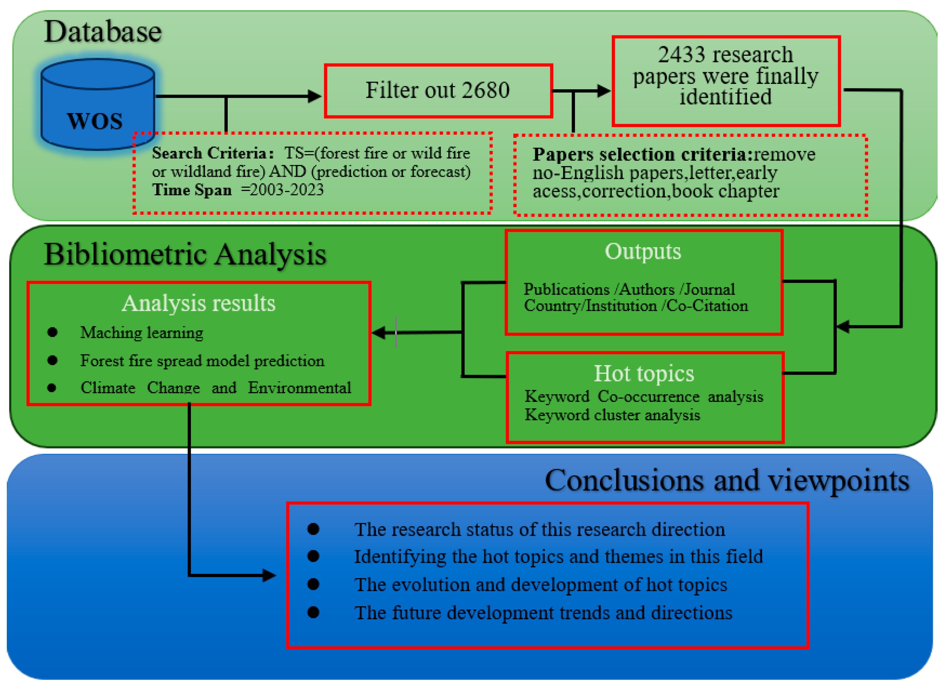
The objective of this study is to conduct a critical thematic review of wildland fire prediction through a bibliometric analysis of existing literature. Four objectives are associated with this goal: (i) comprehensively understand the current state of knowledge on wildland fires, (ii) identify the most influential articles, authors, and journals in the field, (iii) examine the thematic evolution of literature over time, and (iv) identify new trends and potential directions for future research. The organization of this paper is as follows: Section 2 provides an overview of the methods used to obtain relevant data and briefly discusses the software employed in the bibliometric analysis. Section 3 presents the results and visualizations of the bibliometric analysis, including the identification of key themes. Section 4 critically discusses the emerging themes. Finally, the main findings are summarized, and areas requiring further research are reiterated. The research framework is summarized in Figure 1, which provides a visual representation of the study’s methodology and structure.

Figure 1.
A summary of the flowchart and study design.
2. Data and Methods
2.1. Data Source
Web of Science is an internationally recognized database of scientific and technical literature known for its rigorous research standards. The Web of Science Core Collection, a compilation of research source databases, was used for the search. The search query used was “TS = (wildland fire OR wild fire OR forest fire) AND (prediction OR forecast)”, aiming to encompass a wide range of wildland fire prediction research, including forest fires, grassland fires, and tundra fires, where “TS” represents the subject. Data were retrieved on 1 April 2024. The selection criteria for literature were as follows: only “article”-type literature written in English was included, excluding news, notices, and other non-relevant literature. Following screening, a plain text file named “download” was exported. The obtained articles were then processed using CiteSpace software (version 6.1.6), yielding a dataset of 2433 articles.
2.2. Methods
Compared to traditional review methods, which can introduce subjective biases, bibliometric analysis is objective, precise, and effective, allowing for quantitative exploration of the characteristics and patterns inherent to research topics. CiteSpace, a robust visualization tool designed for professional literature analysis, excels in information visualization. Using version 6.1.6 of CiteSpace, we analyzed 2433 scholarly articles (from 2003 to 2023). Our analysis included institutional and country contributions, keyword co-occurrence, clustering, and emergence, resulting in the development of various knowledge maps. The parameters were set as follows: Time Slicing (2003–2023), Year Per Slice (1 year per slice), Path Finder (pathfinding mode), and Pruning (pruning slice networks). For network analysis, we selected the following node types: Author, Cited Journal, Institution, Country, Reference, and Keyword. The author collaboration network map provided insights into the collaboration patterns among authors. The impact of journals was evaluated using their citation network. The institutional cooperation network map identified the institutional collaboration landscape and prominent research organizations. The national collaboration network map highlighted the influence of countries on the field. The significance of individual works was assessed by examining the co-citation relationships among publications. Using the keyword co-occurrence and cluster network maps, we identified the current focal areas in wildland fire prediction research. Analysis of the keyword burst map further elucidated the thematic shifts and emerging trends in wildland fire prediction research.
3. Results and Discussion
3.1. Analysis of Publication Outputs
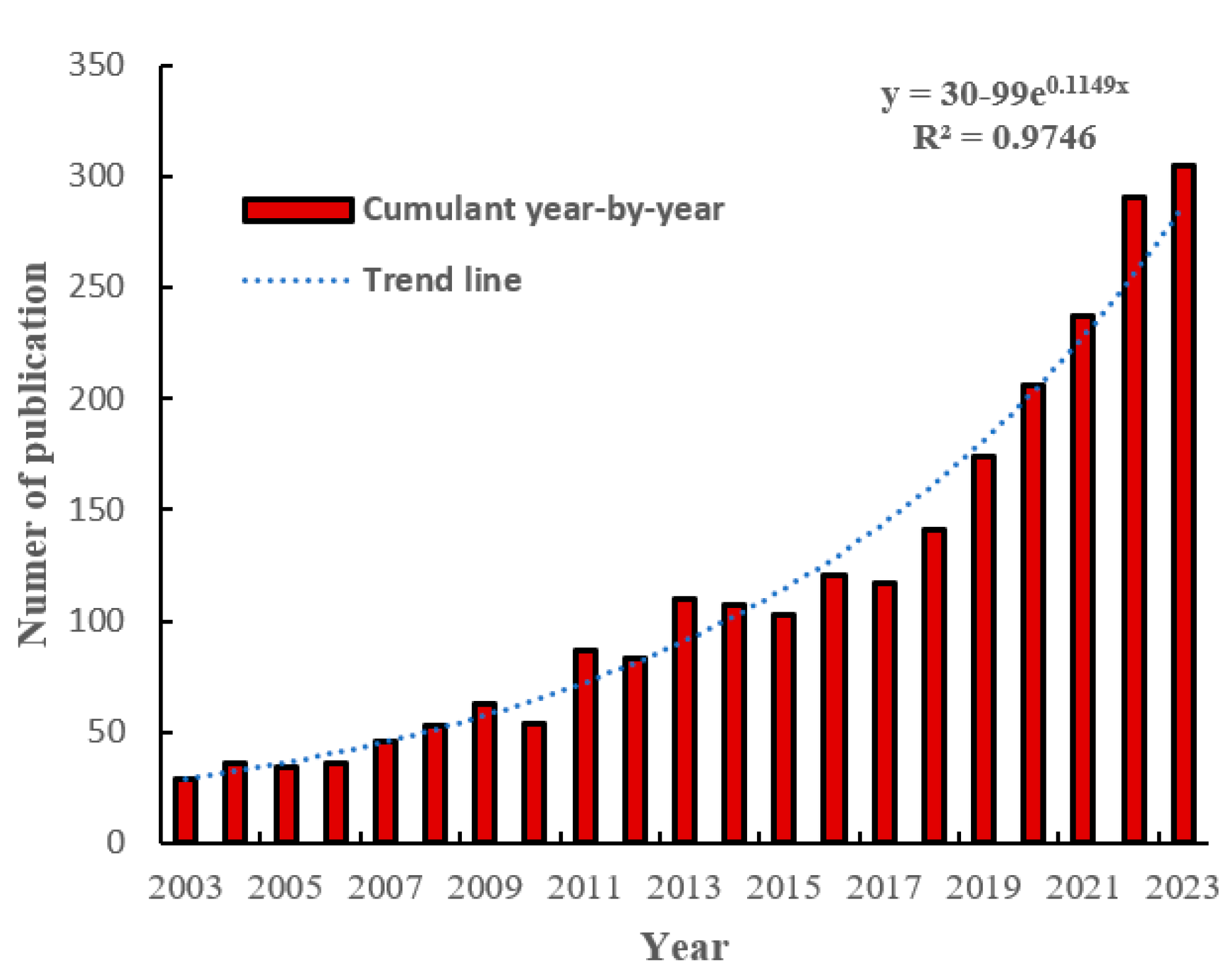
We utilized Microsoft Excel 365 to conduct an analysis of the annual publication volume of literature on wildland fire prediction spanning the last 20 years (Figure 2).By applying Equation (1) with an R2 value greater than 0.9, the trendline demonstrates a high level of reliability.
y = 30-99e0.1149x

Figure 2.
Number of publications in each year from 2003 to 2023.
The trend line indicates a steady increase in the number of publications on wildland fire prediction research, which is anticipated to continue in the future. The period from 2003 to 2010 represented the initial phase of wildland fire prediction research, with an average annual publication count of around 40 papers. Nevertheless, there was a year-on-year increase in publications during this period. In 2003, the Siberian coniferous wildland fire, the largest fire that year worldwide, significantly impacted ozone depletion, underscoring the importance of additional research on wildland fire prediction. The period from 2011 to 2018 experienced rapid growth, with over 100 articles published annually, representing a substantial increase compared to the previous phase. During this period, the Northwest Territories of Canada experienced the largest wildland fire in 30 years, spanning 34,000 square kilometers, which significantly contributed to the advancement of wildland fire management and prediction research in the region. From 2019 to 2023, there was a rapid increase in the number of published papers, with an average annual count of over 240 papers, representing 50% of the total publications in the past 20 years. In recent years, the frequency and scale of wildland fires in various countries increased due to climate change. Notably, the 2020 Australian wildland fire, which burned for 152 days, the 2021 Siberian wildfire that remained uncontrolled, and the largest wildfire in California in 2022 all highlight the impact of climate change on wildland fires. Consequently, the wildland fire prediction research literature during this period emphasized the implications of climate change on wildland fires.
3.2. Analysis of Core Authors
Table 1 presents the top ten contributors to wildland fire prediction research, extracted from the Web of Science database, including data on the number of publications, research topics, and H-index values of contributing authors. The H-index serves as a composite metric to assess both the productivity and impact of researchers. Between 2003 and 2023, a total of 740 authors conducted research related to wildland fire prediction. Currently, the majority of scholarly efforts in this field focus on pre-fire prediction, including the development of models to predict fire likelihood and the modeling of fire spread dynamics after ignition. In addition to conventional predictions of fire probability and simulations of fire propagation, scholars like Robichaud, P. have explored the prediction and evaluation of environmental changes and damages caused by wildland fires [40,41]. Flannigan (highest H-index) has extensively researched the uncertainties inherent in wildfire forecasting due to fluctuating fire drivers influenced by climate change [42,43,44]. In terms of research focus, the simulation of wildland fire spread has garnered considerable scholarly interest. Prolific authors in this domain, including Cortes, Margalef, and Viegas, are recognized for their extensive publication record and robust collaborative efforts, particularly in advancing wildland fire spread simulations through enhanced GPU performance, investigating the role of wind in fire spread dynamics, and developing efficient simulation tools [45,46]. Recent publications reveal a concerted effort by international scholars to refine wildland fire prediction methodologies. These strategies encompass the utilization of machine learning, deep learning, and other advanced algorithms to forecast fire probabilities and design fire spread models and simulators [47,48].

Table 1.
Top 10 Authors in the field of wildland fire prediction research.
3.3. High-Yielding Journals
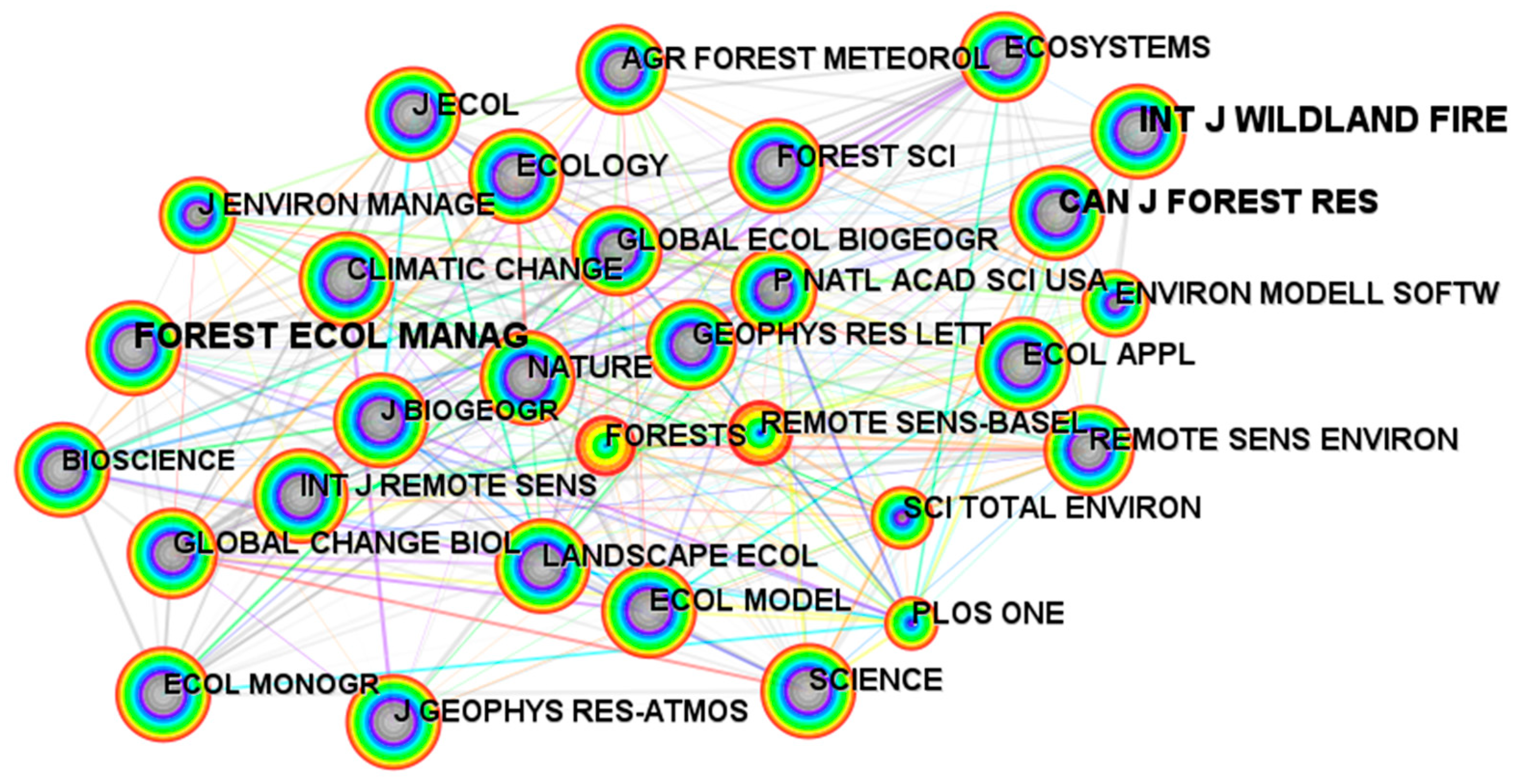
An analysis conducted using data from the Web of Science database revealed that the International Journal of Wildland Fire, with 208 publications, ranks as the leading journal in the domain of wildland fire prediction, followed closely by Forest Ecology and Management (122 publications), Remote Sensing (104 publications), Forests (95 publications), and Fire (80 publications). According to Figure 3, these journals collectively make significant contributions to the field and demonstrate substantial academic engagement. Beyond journals specifically dedicated to wildland fire and forestry topics, Remote Sensing (ranked third) and Remote Sensing of Environment (ranked seventh) feature prominently among the top ten journals by publication volume. Notably, Remote Sensing of Environment is recognized as the premier journal in the realm of remote sensing research. Further insights emerge from utilizing the “Cited Journal” functionality within CiteSpace software, which indicates that the International Journal of Wildland Fire is the most frequently cited journal in the field (1397 citations), trailed by Forest Ecology and Management (1256 citations), the Canadian Journal of Forest Research (919 citations), Science (764 citations), and Ecology (745 citations). Collectively, these five journals exert considerable academic influence in wildland fire prediction studies.
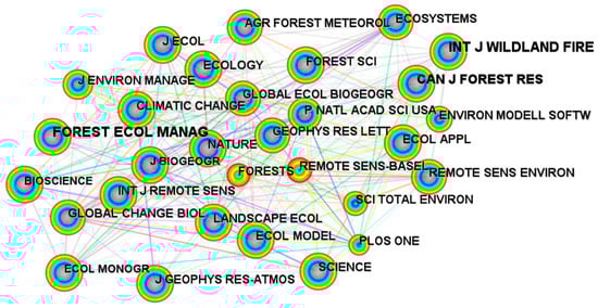
Figure 3.
Cited journal network collaboration map.
3.4. High-Output Countries and Institutes
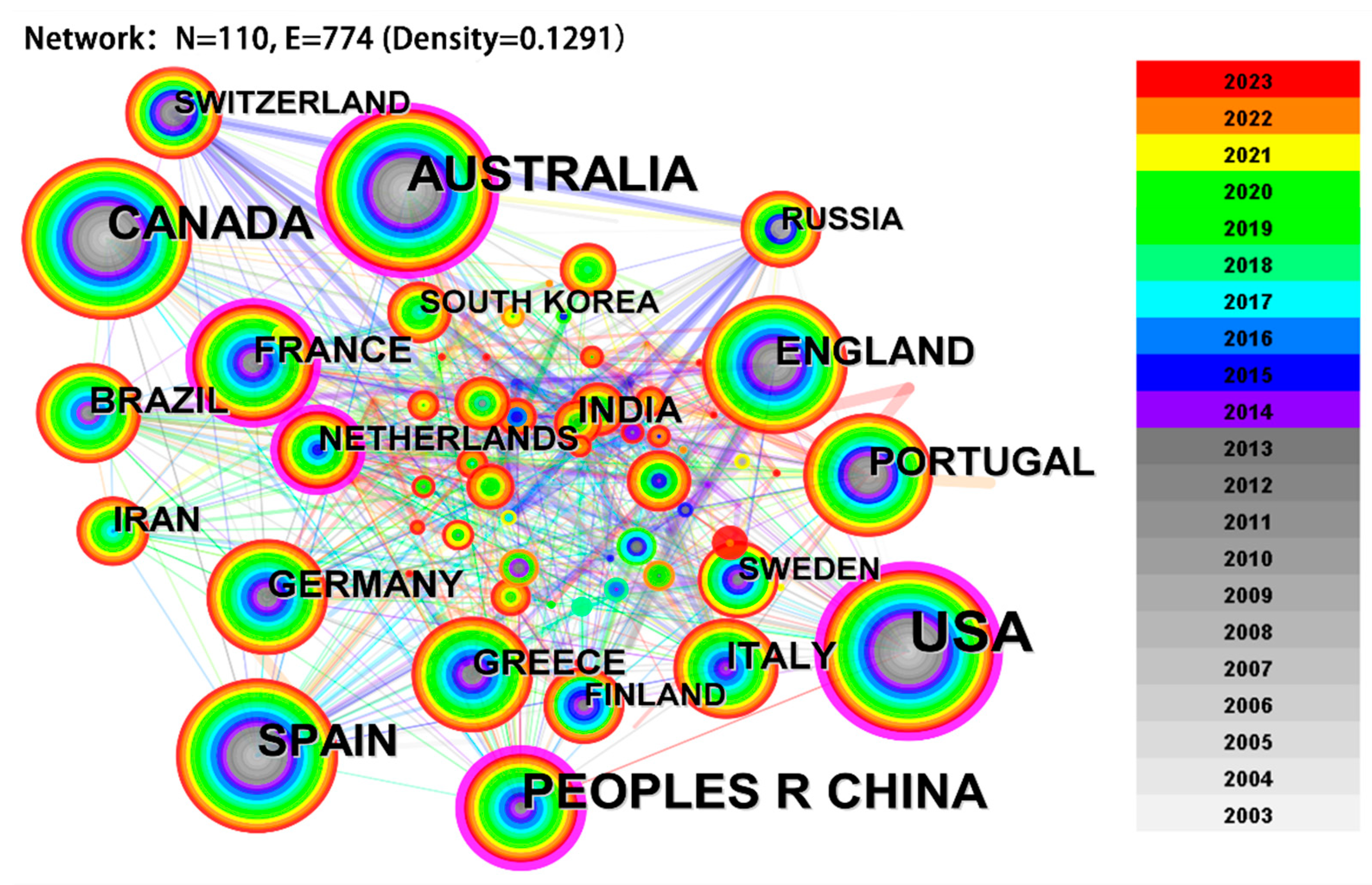
This analysis encompasses data from 110 countries to determine which nations significantly contribute to wildland fire prediction research. Figure 4 visualizes the publication output by country, where “N” represents nodes and “E” denotes links. “Density” is used to indicate the connectivity level between nodes, with larger nodes depicting a higher volume of publications. Nodes highlighted with purple outlines indicate high betweenness centrality, signifying the frequency at which a node serves as a bridge along the shortest path between two other nodes. The density of these lines reflects the strength and frequency of collaborative research between countries. The data reveal that the United States, China, Australia, Canada, and Spain are the top five publishing countries. Notably, Australia, the United States, and Canada have particularly dense networks of collaboration, underscoring their crucial roles in advancing global wildland fire prediction research.

Figure 4.
National cooperation network diagram.
An in-depth analysis was conducted to explore global contributions to wildland fire prediction research, focusing on publication metrics and geographic distribution. Table 2 presents the top ten countries ranked by publication volume, centrality in the research network, and their respective continents. The United States emerges as a dominant force in this field, boasting the highest number of publications and centrality, with 928 papers published between 2003 and 2023. This leadership is likely due to the frequent wildland fire incidents nationwide, especially in California, where substantial wildfire risks have spurred increased research and management efforts in fire prediction. Although China ranks second in publication count, it still significantly trails the United States in research output. Notably, while half of the top ten countries are in Europe, the others are distributed across North America and Asia, underscoring the extensive global collaboration in this vital field.
Table 2.
Statistical data of the top ten countries with the highest publication volume.
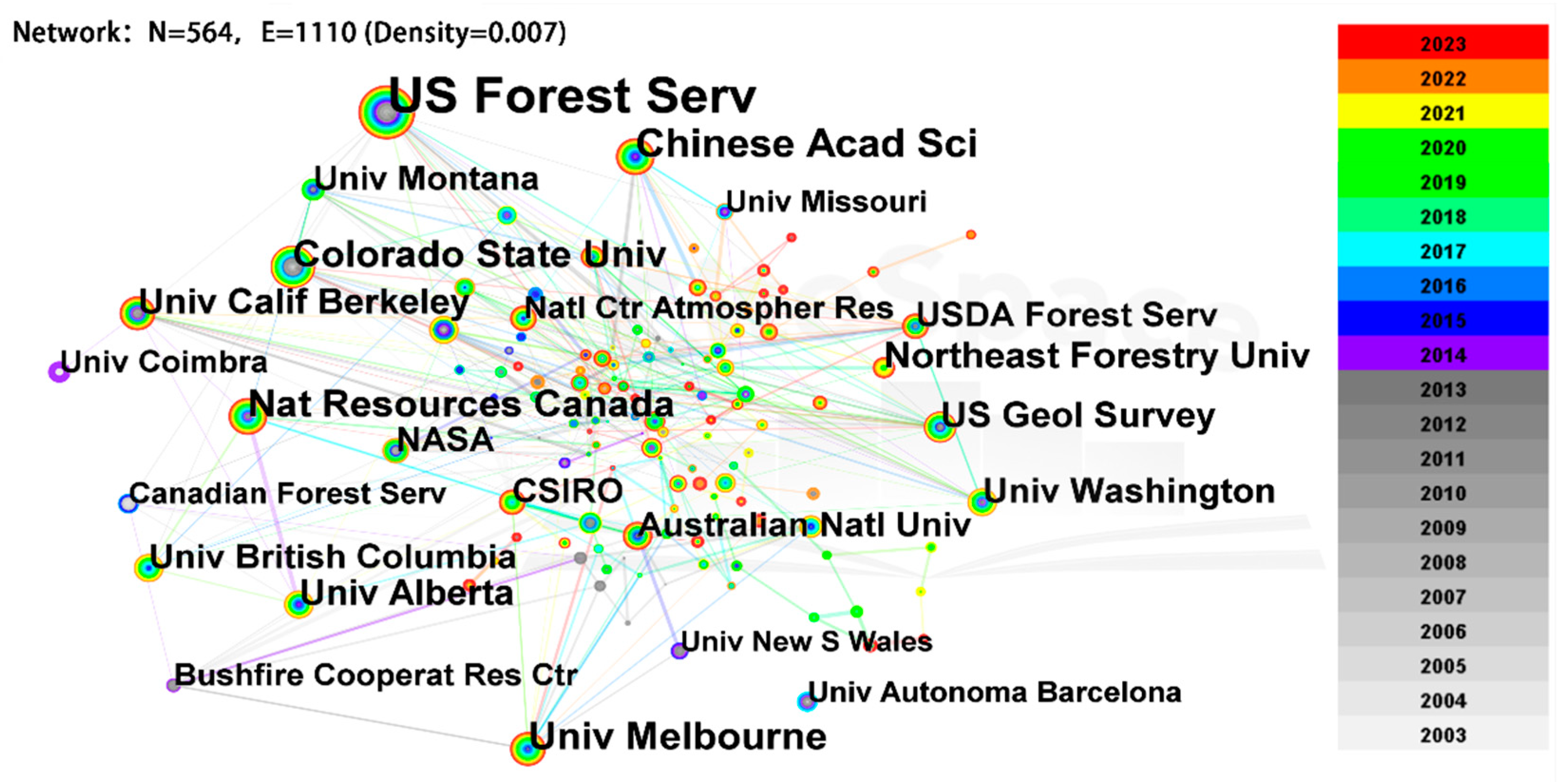
Institutional research depth in the domain of wildland fire prediction varies significantly across different countries, demonstrating a rich tapestry of global contributions. Using CiteSpace software, we constructed a network collaboration map (Figure 5) of institutions involved in wildland fire prediction, comprising 564 nodes and 1110 links, with a network density of 0.007. The analysis identifies the US Forest Service, the Chinese Academy of Sciences, the University of Melbourne, Natural Resources Canada, and Colorado State University as the leading institutions by publication volume. Among these, the US Forest Service holds considerable influence, highlighting its central role in advancing research and knowledge in wildland fire prediction.

Figure 5.
Research institution collaboration network diagram.
This study highlights the crucial role played by leading research institutions in advancing wildland fire prediction. Table 3 details the top ten institutions, primarily universities and national resource bureaus, ranked by the number of published papers in this field (from 2003 to 2023). Notably, the US Forest Service, with 205 articles, leads, followed by the Chinese Academy of Sciences with 64 articles, and the University of Melbourne with 52 articles. These data underscore the dominance of the US Forest Service, both in terms of publication volume and its central position in the network. Furthermore, geographical analysis shows that most of these leading institutions are located in the United States, with significant representation also from China and Canada. This geographic distribution not only reflects a global effort but also underscores extensive collaboration in the vital field of wildland fire prediction.
Table 3.
The top 10 high-productivity institutions.
3.5. Co-Citation Analysis of Papers
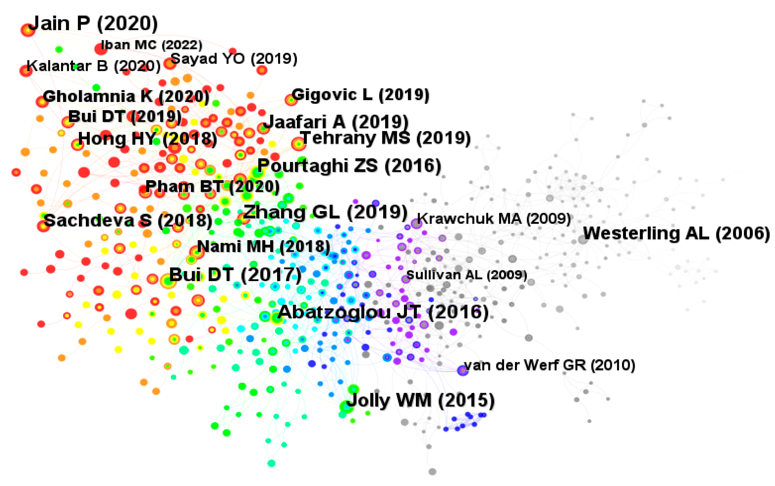
Co-citation analysis, facilitated by software like CiteSpace, provides a valuable method for examining relationships within a field of research. Co-citation occurs when two or more publications are jointly cited by subsequent works, indicating a potential intellectual connection. By visualizing these relationships as networks, researchers can trace the evolution of a field, identifying influential publications and emerging trends. Figure 6, generated using CiteSpace, depicts the co-citation network for wildfire prediction research. Each node represents a publication, with node size correlating to co-citation frequency. The color gradient, progressing from gray to purple, blue, and ultimately red and orange, reflects both the publication’s temporal placement (2003–2023) and its citation frequency, with red signifying the highest. The graph demonstrates a rising trend in citation frequency from 2003 to 2023, peaking in 2019 and 2020. Table 4 lists the top 10 most frequently cited papers, showing that the paper by Jain (2020), with 65 co-citations, emerges as the most frequently cited, significantly impacting wildland fire prediction research. As a review paper and the earliest cited paper in the year, it provides a comprehensive and in-depth overview of machine learning methods for wildland fire prediction, offering significant guidance and theoretical implications for the subsequent application of machine learning in wildland fire prediction research [49].

Figure 6.
Paper co-citation network analysis.
Table 4.
Statistics of the top 10 documents with citation frequency.
The remaining tables categorize highly cited publications into three primary research areas: machine learning-based fire risk prediction models, the impact of climate change on wildfire occurrence [50,51], and analysis of factors influencing wildfire events [52]. Notably, a significant portion (six publications) focus on wildland fire prediction using machine learning. These studies explore various methodologies, including individual machine learning algorithms (e.g., convolutional neural networks) [53], hybrid simulation models integrating GIS and neuro-fuzzy systems [47,54], and combined applications of multiple machine learning algorithms [55,56,57].
3.6. Analysis of Terms
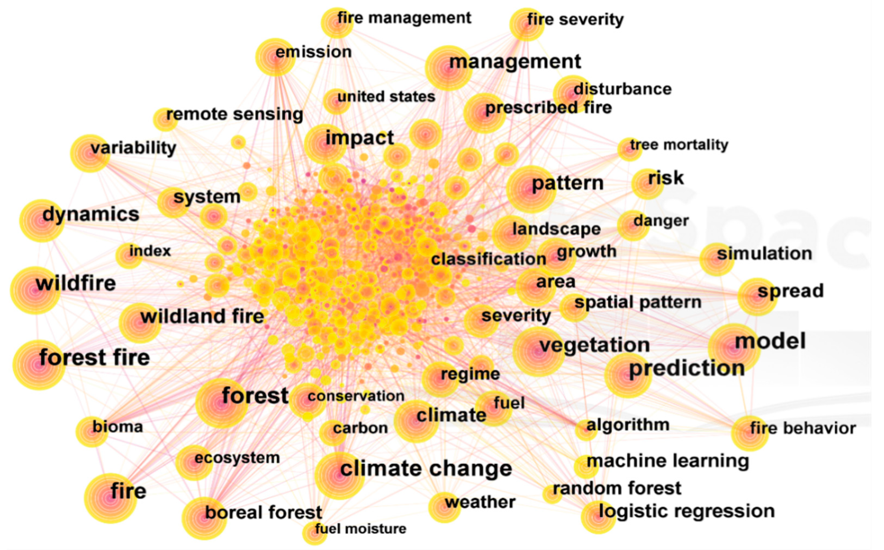
Keywords offer valuable insights into the foundational themes of a research field. By analyzing keyword connections, occurrence frequencies, and co-occurrence patterns, researchers can identify hotspots and emerging trends [58]. Employing CiteSpace software, we conducted a keyword co-occurrence analysis that produced a collinear network map of keywords (Figure 7) and identified the top 20 keywords in wildland fire prediction research (Table 5). The network map includes 657 nodes, each node representing a keyword, where the size of a node indicates the keyword’s occurrence frequency. To enhance visualization, duplicate keywords were removed. In terms of centrality, a metric of keyword influence, “fire”, “climate change”, and “vegetation” emerge as the most influential keywords. The top three keywords with the highest frequency are “model”, “prediction”, and “wildland fire”. Notably, keywords related to wildland fire prediction models include “prediction”, “model”, “machine learning”, and “logistic regression”.
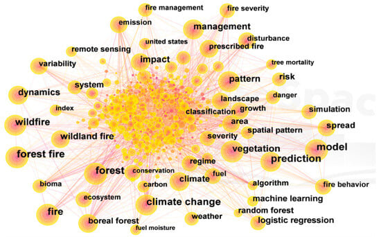
Figure 7.
Keyword co-occurrence network in wildland fire prediction research.
Table 5.
Top 20 high-frequency keywords in wildland fire prediction research.
Wildland fire prediction research initially relied on logistic regression algorithms for regional predictions, yielding moderate accuracy, as exemplified by Fan et al.’s 2007 study, which reported a 70% accuracy rate using binary logistic regression [59]. However, with the advancement of prediction accuracy and the emergence of alternative machine learning algorithms, logistic regression models were surpassed by random forest models, which have become a widely accepted approach in wildland fire prediction. For example, Chen et al.’s 2023 study in Northeast China achieved an accuracy rate of 87.5% using random forest [60]. As the application of diverse machine learning models in wildland fire prediction continues to expand, the demand for model accuracy has concurrently increased. Notably, Truong et al.’s 2023 study introduced a forest fire risk modeling approach that harnesses TensorFlow deep neural networks (TFDeepNN) and geographic information systems (GIS), outperforming random forest (RF), support vector machine (SVM), and logistic regression (LR) models in terms of prediction performance, with an F-score of 0.806, an accuracy rate of 79.3%, and an AUC of 0.873 [61]. The deep learning approach, which can automatically screen data, extract high-dimensional features, and recognize text and images, offers significant potential for enhancing wildland fire prediction research.
The analysis of the keyword co-occurrence network map and the top 20 keywords indicates that current research hotspots in wildland fire prediction encompass model development, climate change impacts, vegetation dynamics, fuel factors, and fire behavior. Keywords such as “climate change”, “vegetation”, “impact”, and “climate” suggest a focus on the causes and driving factors of wildland fires. Keywords like “management, “system”, and “pattern” highlight the importance of fire management strategies to mitigate fire impacts. Research on fire spread dynamics is reflected in keywords such as “dynamics”, “spread”, and “behavior”.
3.7. Analysis of the Keywords Cluster
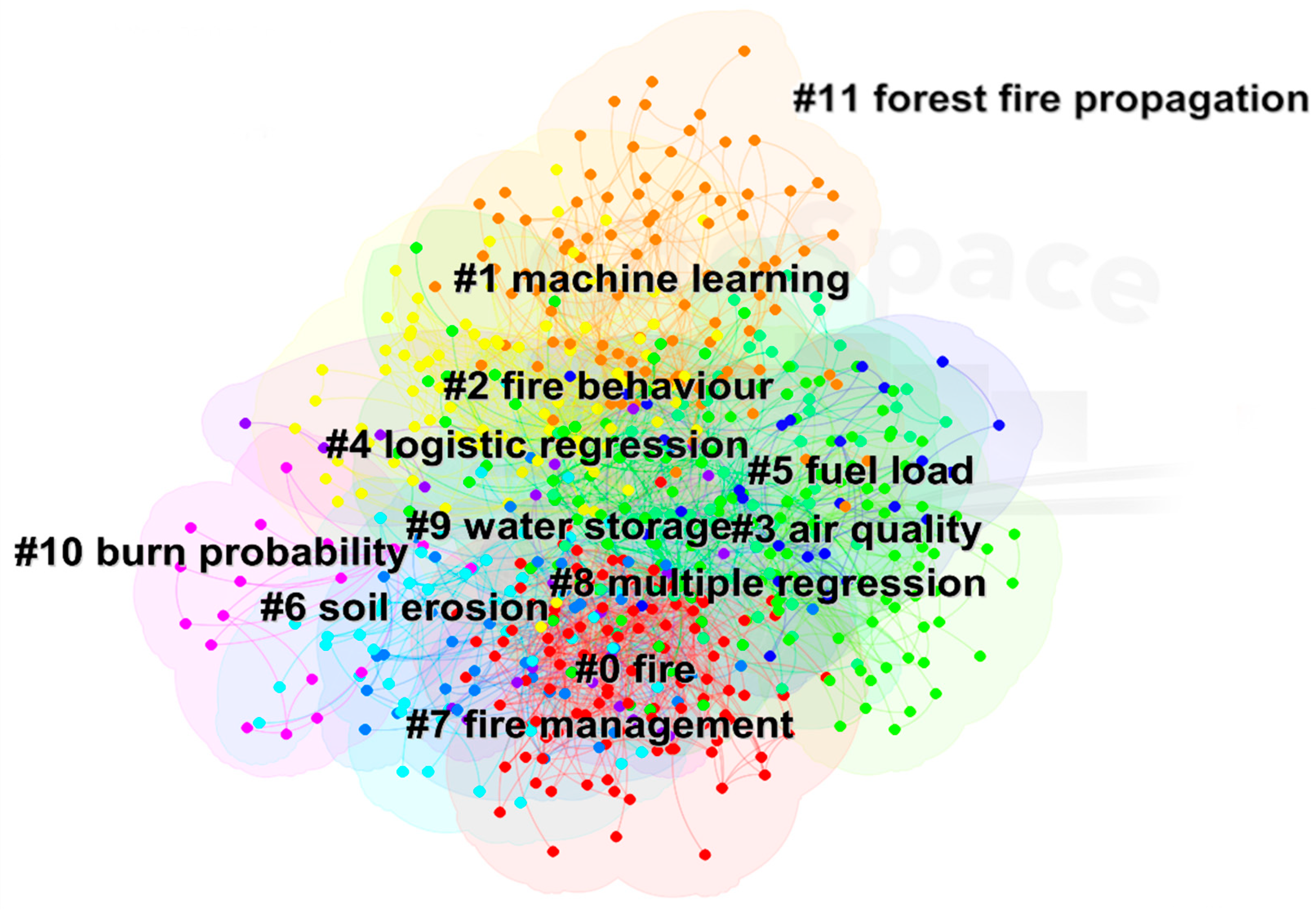
We performed cluster analysis on the keyword co-occurrence map using the log-likelihood rate (LLR) algorithm in CiteSpace 6.1.6, producing the keyword cluster map depicted in Figure 8. We assessed the quality of clustering using modularity (Q) and silhouette (S) values. Generally, a Q-value above 0.3 indicates significant community structure, while an S-value above 0.5 suggests reasonable clustering results, and values above 0.7 indicate highly convincing results. In this analysis, a Q-value of 0.4117 and an S-value of 0.702 signify significant and reliable clustering, respectively. Each cluster contains numerous keywords, with the cluster label’s size indicating the keyword volume. A smaller label number indicates a larger cluster. Table 6 presents the keyword clustering table, which is derived from the graph data. The clustering content with the latest average citation year represents the most recent research hotspots. Based on the 12 clusters identified in the graph, this paper identifies three primary research clusters within the field of wildfire science and management.
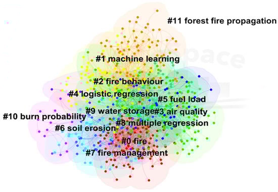
Figure 8.
Keyword cluster map for wildland fire prediction research.
Table 6.
keyword clusters of wildland fire prediction.
This research area primarily focuses on leveraging machine learning algorithms to train models on various wildfire drivers and datasets, ultimately aiming to predict wildfire occurrences. Beyond traditional machine learning algorithms, deep learning and intelligent optimization algorithms, such as the imperialist competitive algorithm, are also gaining traction in wildfire prediction models. While logistic regression (#8) represents an early application in this field, its individual accuracy has been found to be limited. For instance, Goldarag et al. demonstrated that combining logistic regression with artificial neural networks for modeling wildfire risk zones led to significantly improved accuracy compared to using logistic regression alone [62]. Demonstrating the versatility of machine learning, UAVs are increasingly integrated with these technologies for early wildfire detection. Yanik et al. proposed a novel, cost-effective, and accurate early wildfire detection system based on this synergy [63]. Similarly, Le et al. developed a new intelligent approach for wildfire danger modeling using a hybrid model based on the imperialist competitive algorithm (ICA) and relevance vector machines (RVM) [64]. This model outperformed benchmark models like random forest and support vector machines. Among these applications, multiple regression (#8) emerges as a foundational and evolving technique. With its ability to analyze multiple independent and dependent variables, it offers enhanced predictive accuracy. Notably, Zema et al. compared multiple regression models with random forest models in the context of prescribed burning and found that multiple regression provided superior predictions for forest runoff and erosion [65].
The second cluster explores wildfire behavior and spread simulation, encompassing research areas such as fire behavior (#2) and wildland fire propagation (#11). Key themes within this cluster include physics-based simulations, wind field dynamics, domain decomposition techniques, and the application of the Schur method. Current research focuses on developing robust wildfire simulation environments, analyzing the influence of wind field variations on fire spread, and optimizing simulation accuracy through the implementation of cellular automata and other advanced algorithms. For instance, Moinuddin et al. demonstrated that physics-based models outperformed the Mk III and V (McArthur) models in predicting the rate of spread (RoS) under varying wind conditions, although they were surpassed by the CSIRO model in terms of speed [66]. Similarly, cellular automata have emerged as a promising approach for wildfire spread simulations [67], exhibiting enhanced predictive capabilities when integrated with machine learning techniques. Notably, Zheng et al. proposed a novel cellular automata modeling approach by incorporating extreme learning machines (ELM) into traditional wildfire CA frameworks [68]. Their findings highlighted the efficacy of ELM in predicting ignition probabilities for individual cells, demonstrating the proposed method’s ability to accurately capture the impact of wind speed on fire spread patterns.
The third cluster focuses on the environmental impacts of wildfires, emphasizing studies on climate change and soil erosion. This research area encompasses studies related to fire (#0), air quality (#3), soil erosion (#6), and fire management (#7), utilizing keywords such as prescribed burning, soil erodibility, support vector machines, and decision-support tools. Recognizing the substantial environmental damage caused by wildfires, including widespread air pollution, black carbon emissions, and accelerated soil erosion, researchers are increasingly employing tools like machine learning to predict pollution levels and assess the environmental consequences of wildfires [69,70].
3.8. Trend Analysis
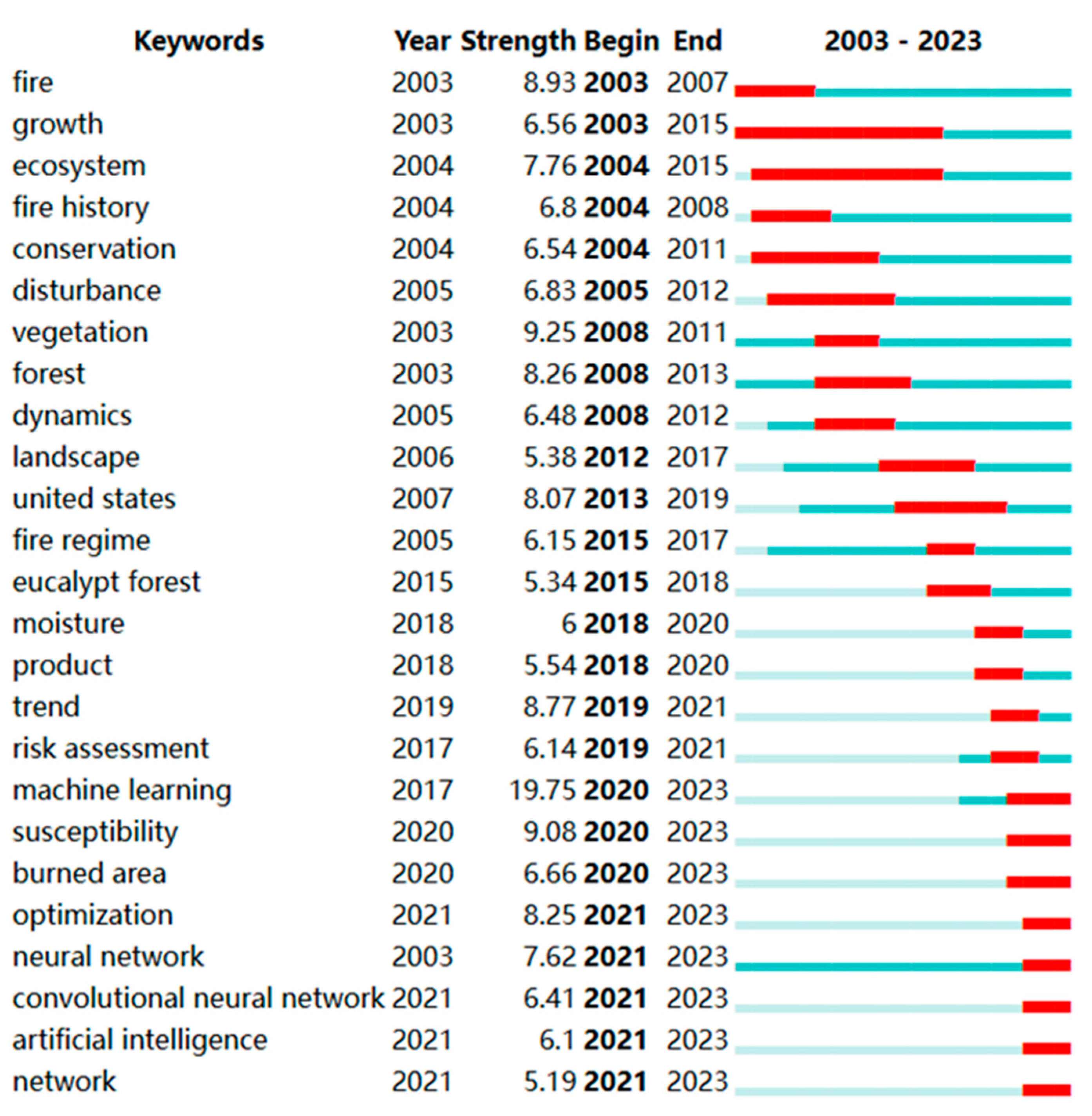
Using CiteSpace software’s co-word analysis feature, burst keywords are identified as those experiencing a rapid increase in citation frequency within a specific timeframe. These keywords offer insights into emerging trends and dynamic changes in a research field during that period. We set the parameter to ‘Burst terms’ in CiteSpace to generate a keyword burst map covering wildland fire prediction research from 2003 to 2023 (Figure 9). The burst strength of a keyword, indicating the magnitude of its citation frequency, represents its influence, with higher values denoting greater impact.
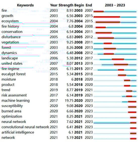
Figure 9.
Top 25 burst keywords with the highest emergent intensity in wildland fire prediction research.
Analysis of the keyword burst map shows that “machine learning” emerged as the keyword with the highest burst strength, registering a burst value of 19.75 between 2020 and 2023. This highlights the growing influence of machine learning in recent years. Keywords such as ‘growth’ and ‘ecosystem’, which displayed the longest burst duration until 2015, indicate an earlier focus on vegetation growth and the impact of fires on ecosystems. Notably, keywords that have shown recent bursts from their start dates to the present suggest potential directions for future research. These include “machine learning”, “susceptibility”, “burned area”, “optimization”, “neural network”, “convolution neural network”, “artificial intelligence”, and “network”.
3.8.1. Machine Learning
From 2003 to 2023, keyword co-occurrence and cluster network analysis reveal that ‘machine learning’ appears 119 times, ranks as cluster #1, and shows the highest emergence intensity at 19.75. As a subfield of artificial intelligence, machine learning uses algorithms to discern patterns in datasets and make predictions, particularly excelling when the data are robust [71,72]. The development of artificial intelligence is paramount in wildland fire prediction research, encompassing various algorithmic applications such as machine learning, deep learning, and integrated learning [32]. Keyword analysis indicates that logistic regression and random forest models are commonly employed in current prediction models. However, a consensus among researchers suggests that random forest models exhibit higher prediction accuracy compared to logistic regression models. For instance, Bo Yu et al. achieved a correlation coefficient of 0.987 and a mean square error of 0.00285 in Cambodia by training a random forest model with remote sensing data [73]. This demonstrates the model’s high efficiency and accuracy in predicting fire occurrence. Shrma et al. evaluated the accuracy of six machine learning algorithms in Indian rainforests, concluding that support vector machines and artificial neural networks displayed superior performance [74]. Ge et al. proposed a wildland fire prediction method integrating a spatio-temporal knowledge graph and a machine learning model. By constructing a wildland fire semantic ontology and spatio-temporal framework based on the knowledge graph, this method fuses multi-source heterogeneous spatio-temporal wildland fire data, achieving high prediction performance in experimental predictions for Xichang City and Yanyuan City in Sichuan Province [75]. With ongoing research in machine learning, numerous models have demonstrated accuracy comparable to that of random forest models. Gao et al., utilizing local historical disaster data and meteorological and topographic data, applied both random forest and back propagation neural network models to predict wildland fires in Heilongjiang province [76]. Their findings indicate that both algorithms achieve high prediction accuracy and goodness of fit.
Advancements in machine learning have spurred explorations into deep learning and integrated learning for enhancing wildland fire prediction [77]. You et al. employed a particle swarm optimization algorithm to evolve the optimal architecture and parameters for a convolutional neural network deep learning model [78]. The prediction results for wildland fire risk across China surpassed those of single random forest, support vector machine, and convolutional neural network models, achieving a prediction accuracy rate of 82.2%. While deep learning excels in processing large-scale complex data and images, integrated learning combines multiple models to enhance prediction accuracy. Li et al. applied an integrated approach using random forest, extreme gradient boosting, LightGBM, and multi-layer perceptron models to analyze diverse data types such as weather, terrain, vegetation, and human activities. The area under the receiver operating characteristic curve (ROC value) reached 0.970, significantly exceeding the predictive capabilities of single machine learning models.
The application of diverse algorithm models aims to minimize manual calculations. Remote sensing satellites, using fire point temperatures, can also predict wildland fires to a certain extent, offering an alternative to the predictive algorithms of machine learning models. However, manual interpretation of remote sensing images presents significant workloads and limited accuracy. Algorithm optimization enhances recognition efficiency. Vegetation water content and combustible content are crucial indicators for assessing wildland fire occurrence. Adab et al. applied artificial neural networks and multiple linear regression to predict forest leaf water content using MODIS remote sensing data in northern Iran, enabling near-real-time detection in fire-prone areas [79].
3.8.2. Wildland Fire Spread Model Prediction
Key terms in wildland fire spread research include “spread”, “behavior”, and “dynamics”, encompassed under keyword cluster #11, “wildland fire propagation”. The prediction of wildland fire behavior during outbreaks has been extensively researched by scholars. When wildland fires cannot be prevented, accurately predicting their spreading direction can significantly enhance fire suppression success rates and mitigate disaster impacts. Since the early 20th century, research on wildland fire spread simulation has evolved, with prominent models such as the Rothermel model in the United States [80], the McArthur model in Australia [81], and the Wang Zhengfei model in China [82]. Enhancements to these models, such as Yao Yanxia et al.’s coupling of the Rothermel model with particle systems, have improved simulation accuracy and realism [83]. In model simulations, wind field factors are crucial; accounting for variables like terrain that influence wind field changes is essential to reduce simulation errors. Increasingly, researchers are integrating the WRF meteorological model to enhance predictions of wind trends and simulation accuracy. Due to their simplicity and low computational complexity, cellular automata have become widely used in wildland fire spread modeling. Rui et al. coupled cellular automata with wildland fire models, demonstrating high spatiotemporal synchronization with fire spread in the Greater Khingan Mountains in 2006 [84]. GIS applications, in conjunction with wildland fire spread simulation models, have proven to be both extensive and efficient. GIS can simulate fire spread paths and speeds, predict fire spreading directions, and provide early warning and planning support for fire occurrence decision-making. For instance, S-Yassemi et al. developed a fire behavior model combining terrain, forest fuels, and meteorological factors, which can effectively simulate real wildland fire scenes and generate real-time dynamic images [85].
3.8.3. Climate Change and Environmental Changes Caused by Wildland Fires
Climate change is a significant driver of environmental changes, profoundly affecting wildland fire dynamics [86]. In our analysis, key terms related to climate change appeared 333 times, with the keyword clustering diagram linking terms like “fire” (#0) and “air quality” (#3) to climate change. In the background of large-scale wildland fires around the world, climate change factors play a significant role in driving these events [87]. Temperature anomalies and altered precipitation patterns, driven by climate change, not only fluctuate the probability of wildland fires but also increase their frequency and severity [88]. Mina et al. found that the frequency of wildland fires in the northern Indian state of Uttarakhand was significantly correlated with local temperature (maximum, average, and diurnal temperature range) changes, with temperature being a key factor in wildland fire likelihood [89]. Climate change-driven high temperatures can lead to an increase in the number of flammable materials within forests, reducing water content and increasing the likelihood of wildland fires. Climate change-driven changes in forest internal humidity and precipitation can also lead to faster burning of flammable materials.
The increasing susceptibility of forest ecosystems to fires amid climate change remains a pressing concern for researchers. This vulnerability is underscored by several studies that attribute the increasing frequency of wildland fires to abnormally high temperatures caused by climate change [90,91]. These temperature extremes lead to a higher amount of fuel in the forest and lower moisture content in trees, exacerbating the susceptibility to wildland fires [92]. Employing artificial neural networks and support vector machine models, Sakr et al. effectively predicted wildland fire occurrences with high accuracy based on two critical parameters: cumulative precipitation and average humidity [93]. Their research further elucidated that climate change induces lower humidity and altered precipitation patterns within forests, rendering combustibles more susceptible to ignition.
Moreover, the impact of climate change on wind patterns cannot be understated. Changes in wind direction, including the prevalence of valley winds and Foehn winds, are found to increase the susceptibility to wildland fires. In New Zealand, Siena Brody-Heine et al. found that variations in wind speed and direction, shaped by weather systems and localized meteorological processes, significantly affect fire intensity and spread [94]. Expanding on the implications of wildland fires, some scholars have delved into the subsequent effects on climate and emissions. Liu et al. established a compelling link between climate change, the greenhouse effect, and the rising number of wildland fires globally [95]. The smoke particles released during these fires contain black carbon, which contributes to the warming of the middle and lower atmospheres, exerting a notable impact on climate dynamics.
Building upon these findings, KITCH et al. uncovered another dimension of wildland fires’ influence on the atmosphere [96]. They discovered that pyrocumulonimbus clouds, formed during intense wildland fires, can directly inject smoke into the stratosphere, leading to a certain level of black carbon and organic aerosol pollution. In a separate study, ZEMA et al. examined the effects of planned burning on surface runoff and soil erosion [65]. Utilizing a random forest algorithm model and a variable regression model, they predicted that planned burning would result in increased surface runoff and heightened soil erosion. Additionally, they noted that rainfall anomalies induced by climate change play a role in influencing the incidence of wildland fires [97].
In conclusion, the complex relationship between climate change and forest ecosystems crucially demands heightened attention. Temperature anomalies and environmental changes stemming from climate change are pivotal factors that hinder accurate wildland fire predictions. FILL et al. substantiated this challenge by demonstrating how climate change has prolonged dry seasons, reduced rainfall, and sustained periods of thunderstorms in the coastal plains of the southeastern United States, thereby elevating the probability of lightning strikes and subsequent wildland fires [98]. Consequently, when forecasting wildland fires in specific regions, it is imperative to incorporate climate change considerations into the analytical framework.
4. Conclusions
This study conducted a systematic literature review and analysis of forest fire prediction-related literature, focusing on research themes, hotspots, and publication trends. The analysis aimed to provide insights into the development trajectory of forest fire prediction and inform future research directions.
- This systematic literature review provides reliable results and understanding. The analysis demonstrates that research in the field of wildfire prediction is growing, with particular increases from 2019 to 2023. The majority of research institutions are from the United States Forest Service and the Chinese Academy of Sciences, with publications primarily distributed in forestry and remote sensing journals. The top-cited journals are the International Journal of Wildland Fire, Forest Ecology and Management, Remote Sensing, and Forests. The top 10 countries in terms of publication count are from Europe, with the United States and China being the top two. According to the high-frequency authors’ research content, the main research topics in forest fire prediction include applying models to predict fire occurrence probability, predicting and simulating fire spread, predicting environmental changes after fire, and the impact of climate change on fire prediction. The most cited paper is Jain P’s 2020 review article on machine learning in forest fire prediction, which will have a significant influence on the development of this field in the future. Future research can consider more fire-driven factors and compare different algorithm models to achieve higher accuracy.
- The literature analysis reveals that the hotspots of forest fire prediction research include machine learning applications in forest fire prediction, the impact of climate change on fire prediction, fire spread simulation, and environmental impact prediction. Since 2020, there has been a significant increase in the application of machine learning in forest fire prediction. Although machine learning has shown high accuracy, other algorithms, such as deep learning and ensemble learning, have also demonstrated strong performance in wildfire prediction. The accuracy of most models used is closely related to the selection of fire-driven factors.
- According to multiple data, deep learning and ensemble learning have higher accuracy rates in forest fire prediction than single machine learning algorithm models, indicating the future research trend in this field.
- Fire spread simulation and prediction are based on simulating and predicting fire behavior after a fire has occurred, and cellular automata have high applicability in simulating fire behavior. However, the analysis suggests that combining machine learning with cellular automata will significantly improve simulation efficiency and accuracy.
- Climate change factors are crucial considerations in wildfire prediction work, not only due to internal changes in the forest but also external meteorological changes that have a significant impact on the forest environment. Accurately predicting fire occurrence under the influence of climate change is a future research trend.
- Although fire prediction is primarily focused on fire behavior and fire occurrence probability, predicting the environmental impact and ecological damage caused by fire is also a requirement for forest fire managers. Incorporating predictions of environmental impact and ecological damage into wildfire prediction models could provide valuable insights for wildfire managers and support more comprehensive wildfire management strategies.
Author Contributions
Conceptualization, M.B.; methodology, M.B.; software, C.C.; validation, J.L. (Jiahao Liu), H.R. and S.L.; formal analysis, C.R.; investigation, J.L. (Jianxiang Liu); resources, J.L. (Jianxiang Liu); funding acquisition, J.L. (Jianxiang Liu). All authors have read and agreed to the published version of the manuscript.
Funding
This research received no external funding.
Conflicts of Interest
The authors declare no conflict of interest.
References
- Liang, J.; Crowther, T.W.; Picard, N.; Wiser, S.; Zhou, M.; Alberti, G.; Schulze, E.-D.; McGuire, A.D.; Bozzato, F.; Pretzsch, H.; et al. Positive biodiversity-productivity relationship predominant in global forests. Science 2016, 354, aaf8957. [Google Scholar] [CrossRef] [PubMed]
- Augusto, L.; Boca, A. Tree functional traits, forest biomass, and tree species diversity interact with site properties to drive forest soil carbon. Nat. Commun. 2022, 13, 1097. [Google Scholar] [CrossRef] [PubMed]
- Lehmann, C.E.R.; Anderson, T.M.; Sankaran, M.; Higgins, S.I.; Archibald, S.; Hoffmann, W.A.; Hanan, N.P.; Williams, R.J.; Fensham, R.J.; Felfili, J.; et al. Savanna Vegetation-Fire-Climate Relationships Differ Among Continents. Science 2014, 343, 548–552. [Google Scholar] [CrossRef] [PubMed]
- Hubau, W.; Lewis, S.L.; Phillips, O.L.; Affum-Baffoe, K.; Beeckman, H.; Cuni-Sanchez, A.; Daniels, A.K.; Ewango, C.E.N.; Fauset, S.; Mukinzi, J.M.; et al. Asynchronous carbon sink saturation in African and Amazonian tropical forests. Nature 2020, 579, 80–87. [Google Scholar] [CrossRef]
- Zheng, B.; Ciais, P.; Chevallier, F.; Chuvieco, E.; Chen, Y.; Yang, H. Increasing forest fire emissions despite the decline in global burned area. Sci. Adv. 2021, 7, eabh2646. [Google Scholar] [CrossRef] [PubMed]
- Li, Y.; Zhao, M.; Motesharrei, S.; Mu, Q.; Kalnay, E.; Li, S. Local cooling and warming effects of forests based on satellite observations. Nat. Commun. 2015, 6, 6603. [Google Scholar] [CrossRef] [PubMed]
- Chagas, V.B.P.; Chaffe, P.L.B.; Bloeschl, G. Climate and land management accelerate the Brazilian water cycle. Nat. Commun. 2022, 13, 5136. [Google Scholar] [CrossRef] [PubMed]
- Cambi, M.; Certini, G.; Neri, F.; Marchi, E. The impact of heavy traffic on forest soils: A review. For. Ecol. Manag. 2015, 338, 124–138. [Google Scholar] [CrossRef]
- Ceccherini, G.; Duveiller, G.; Grassi, G.; Lemoine, G.; Avitabile, V.; Pilli, R.; Cescatti, A. Abrupt increase in harvested forest area over Europe after 2015. Nature 2020, 583, 72–77. [Google Scholar] [CrossRef]
- Radeloff, V.C.; Helmers, D.P.; Kramer, H.A.; Mockrin, M.H.; Alexandre, P.M.; Bar-Massada, A.; Butsic, V.; Hawbaker, T.J.; Martinuzzi, S.; Syphard, A.D.; et al. Rapid growth of the US wildland-urban interface raises wildfire risk. Proc. Natl. Acad. Sci. USA 2018, 115, 3314–3319. [Google Scholar] [CrossRef]
- Bodi, M.B.; Martin, D.A.; Balfour, V.N.; Santin, C.; Doerr, S.H.; Pereira, P.; Cerda, A.; Mataix-Solera, J. Wild land fire ash: Production, composition and eco-hydro-geomorphic effects. Earth-Sci. Rev. 2014, 130, 103–127. [Google Scholar] [CrossRef]
- Moritz, M.A.; Batllori, E.; Bradstock, R.A.; Gill, A.M.; Handmer, J.; Hessburg, P.F.; Leonard, J.; McCaffrey, S.; Odion, D.C.; Schoennagel, T.; et al. Learning to coexist with wildfire. Nature 2014, 515, 58–66. [Google Scholar] [CrossRef] [PubMed]
- Schoennagel, T.; Balch, J.K.; Brenkert-Smith, H.; Dennison, P.E.; Harvey, B.J.; Krawchuk, M.A.; Mietkiewicz, N.; Morgan, P.; Moritz, M.A.; Rasker, R.; et al. Adapt to more wildfire in western North American forests as climate changes. Proc. Natl. Acad. Sci. USA 2017, 114, 4582–4590. [Google Scholar] [CrossRef] [PubMed]
- Chu, L.; Grafton, R.Q.; Nelson, H. Accounting for forest fire risks: Global insights for climate change mitigation. Mitig. Adapt. Strateg. Glob. Chang. 2023, 28, 41. [Google Scholar] [CrossRef]
- Wang, X.; Oliver, J.; Swystun, T.; Hanes, C.C.; Erni, S.; Flannigan, M.D. Critical fire weather conditions during active fire spread days in Canada. Sci. Total Environ. 2023, 869, 161831. [Google Scholar] [CrossRef] [PubMed]
- Volkova, L.; Fernández, M.E. Wildfires in a changing world. For. Ecol. Manag. 2024, 556, 4. [Google Scholar] [CrossRef]
- Kadir, E.A.; Rosa, S.L.; Syukur, A.; Othman, M.; Daud, H. Forest fire spreading and carbon concentration identification in tropical region Indonesia. Alex. Eng. J. 2022, 61, 1551–1561. [Google Scholar] [CrossRef]
- Kalogiannidis, S.; Chatzitheodoridis, F.; Kalfas, D.; Patitsa, C.; Papagrigoriou, A. Socio-Psychological, Economic and Environmental Effects of Forest Fires. Fire 2023, 6, 280. [Google Scholar] [CrossRef]
- Jolly, W.M.; Freeborn, P.H.; Page, W.G.; Butler, B.W. Severe Fire Danger Index: A Forecastable Metric to Inform Firefighter and Community Wildfire Risk Management. Fire 2019, 2, 47. [Google Scholar] [CrossRef]
- Beck, J.A.; Alexander, M.E.; Harvey, S.D.; Beaver, A.K. Forecasting diurnal variations in fire intensity to enhance wildland firefighter safety. Int. J. Wildland Fire 2002, 11, 173–182. [Google Scholar] [CrossRef]
- Coen, J.L.; Schroeder, W.; Conway, S.; Tarnay, L. Computational modeling of extreme wildland fire events: A synthesis of scientific understanding with applications to forecasting, land management, and firefighter safety. J. Comput. Sci. 2020, 46, 101226. [Google Scholar] [CrossRef]
- Acuna, M.A.; Palma, C.D.; Cui, W.; Martell, D.L.; Weintraub, A. Integrated spatial fire and forest management planning. Can. J. For. Res. 2010, 40, 2370–2383. [Google Scholar] [CrossRef]
- Sook, C.Y.; Soo, S.H. Vulnerability of Pinus densiflora to forest fire based on ignition characteristics. J. Ecol. Environ. 2010, 33, 343–349. [Google Scholar]
- Encinas, L.H.; White, S.H.; del Rey, A.M.; Sanchez, G.R. Modelling forest fire spread using hexagonal cellular automata. Appl. Math. Model. 2007, 31, 1213–1227. [Google Scholar] [CrossRef]
- Mutthulakshmi, K.; Wee, M.R.E.; Wong, Y.C.K.; Lai, J.W.; Koh, J.M.; Acharya, U.R.; Cheong, K.H. Simulating forest fire spread and fire-fighting using cellular automata. Chin. J. Phys. 2020, 65, 642–650. [Google Scholar] [CrossRef]
- Meng, Q.; Lu, H.; Huai, Y.; Xu, H.; Yang, S. Forest Fire Spread Simulation and Fire Extinguishing Visualization Research. Forests 2023, 14, 1371. [Google Scholar] [CrossRef]
- Barroso, P.M.; Winkler, J.; Vaverkova, M.D.; Oulehla, J. Aided Phytoremediation in Fire-Affected Forest Soil. Fire 2022, 5, 82. [Google Scholar] [CrossRef]
- Pakhtigian, E.L.; Pattanayak, S.K.; Tan-Soo, J.-S. Forest Fires, Smoky Kitchens, and Human Health in Indonesia. Environ. Resour. Econ. 2024. [Google Scholar] [CrossRef]
- Romanchuck, L.D.; Ustymenko, V.I. Effect of Forest Fires on Forest Plant Complexes Contaminated by Radionuclides. Nucl. Phys. At. Energy 2022, 23, 195–206. [Google Scholar] [CrossRef]
- Dieu Tien, B.; Nhat-Duc, H.; Samui, P. Spatial pattern analysis and prediction of forest fire using new machine learning approach of Multivariate Adaptive Regression Splines and Differential Flower Pollination optimization: A case study at Lao Cai province (Viet Nam). J. Environ. Manag. 2019, 237, 476–487. [Google Scholar] [CrossRef]
- Alexandridis, A.; Vakalis, D.; Siettos, C.I.; Bafas, G.V. A cellular automata model for forest fire spread prediction: The case of the wildfire that swept through Spetses Island in 1990. Appl. Math. Comput. 2008, 204, 191–201. [Google Scholar] [CrossRef]
- Ghali, R.; Akhloufi, M.A. Deep Learning Approaches for Wildland Fires Remote Sensing: Classification, Detection, and Segmentation. Remote Sens. 2023, 15, 1821. [Google Scholar] [CrossRef]
- Hamilton, D.; Levandovsky, E.; Hamilton, N. Mapping Burn Extent of Large Wildland Fires from Satellite Imagery Using Machine Learning Trained from Localized Hyperspatial Imagery. Remote Sens. 2020, 12, 4097. [Google Scholar] [CrossRef]
- Toulouse, T.; Rossi, L.; Celik, T.; Akhloufi, M. Automatic fire pixel detection using image processing: A comparative analysis of rule-based and machine learning-based methods. Signal Image Video Process. 2016, 10, 647–654. [Google Scholar] [CrossRef]
- Allaire, F.; Mallet, V.; Filippi, J.-B. Emulation of wildland fire spread simulation using deep learning. Neural Netw. 2021, 141, 184–198. [Google Scholar] [CrossRef]
- Hodges, J.L.; Lattimer, B.Y. Wildland Fire Spread Modeling Using Convolutional Neural Networks. Fire Technol. 2019, 55, 2115–2142. [Google Scholar] [CrossRef]
- McCandless, T.C.; Kosovic, B.; Petzke, W. Enhancing wildfire spread modelling by building a gridded fuel moisture content product with machine learning. Mach. Learn.-Sci. Technol. 2020, 1, 035010. [Google Scholar] [CrossRef]
- Chen, C.M. CiteSpace II: Detecting and visualizing emerging trends and transient patterns in scientific literature. J. Am. Soc. Inf. Sci. Technol. 2006, 57, 359–377. [Google Scholar] [CrossRef]
- Pan, X.; Yan, E.; Cui, M.; Hua, W. Examining the usage, citation, and diffusion patterns of bibliometric mapping software: A comparative study of three tools. J. Informetr. 2018, 12, 481–493. [Google Scholar] [CrossRef]
- Robichaud, P.R. Fire effects on infiltration rates after prescribed fire in Northern Rocky Mountain forests, USA. J. Hydrol. 2000, 231, 220–229. [Google Scholar] [CrossRef]
- Robichaud, P.R.; Lewis, S.A.; Wagenbrenner, J.W.; Ashmun, L.E.; Brown, R.E. Post-fire mulching for runoff and erosion mitigation Part I: Effectiveness at reducing hillslope erosion rates. Catena 2013, 105, 75–92. [Google Scholar] [CrossRef]
- Flannigan, M.; Stocks, B.; Turetsky, M.; Wotton, M. Impacts of climate change on fire activity and fire management in the circumboreal forest. Glob. Chang. Biol. 2009, 15, 549–560. [Google Scholar] [CrossRef]
- Flannigan, M.D.; Krawchuk, M.A.; de Groot, W.J.; Wotton, B.M.; Gowman, L.M. Implications of changing climate for global wildland fire. Int. J. Wildland Fire 2009, 18, 483–507. [Google Scholar] [CrossRef]
- Flannigan, M.D.; Stocks, B.J.; Wotton, B.M. Climate change and forest fires. Sci. Total Environ. 2000, 262, 221–229. [Google Scholar] [CrossRef] [PubMed]
- Cencerrado, A.; Cortes, A.; Margalef, T. Response time assessment in forest fire spread simulation: An integrated methodology for efficient exploitation of available prediction time. Environ. Model. Softw. 2014, 54, 153–164. [Google Scholar] [CrossRef]
- Viegas, D.X. Forest fire propagation. Philos. Trans. R. Soc. A-Math. Phys. Eng. Sci. 1998, 356, 2907–2928. [Google Scholar] [CrossRef]
- Dieu Tien, B.; Quang-Thanh, B.; Quoc-Phi, N.; Pradhan, B.; Nampak, H.; Phan Trong, T. A hybrid artificial intelligence approach using GIS-based neural-fuzzy inference system and particle swarm optimization for forest fire susceptibility modeling at a tropical area. Agric. For. Meteorol. 2017, 233, 32–44. [Google Scholar] [CrossRef]
- Gibson, R.; Danaher, T.; Hehir, W.; Collins, L. A remote sensing approach to mapping fire severity in south-eastern Australia using sentinel 2 and random forest. Remote Sens. Environ. 2020, 240, 111702. [Google Scholar] [CrossRef]
- Jain, P.; Coogan, S.C.P.; Subramanian, S.G.; Crowley, M.; Taylor, S.; Flannigan, M.D. A review of machine learning applications in wildfire science and management. Environ. Rev. 2020, 28, 478–505. [Google Scholar] [CrossRef]
- Abatzoglou, J.T.; Williams, A.P. Impact of anthropogenic climate change on wildfire across western US forests. Proc. Natl. Acad. Sci. USA 2016, 113, 11770–11775. [Google Scholar] [CrossRef]
- Jolly, W.M.; Cochrane, M.A.; Freeborn, P.H.; Holden, Z.A.; Brown, T.J.; Williamson, G.J.; Bowman, D.M.J.S. Climate-induced variations in global wildfire danger from 1979 to 2013. Nat. Commun. 2015, 6, 7537. [Google Scholar] [CrossRef] [PubMed]
- Pourtaghi, Z.S.; Pourghasemi, H.R.; Aretano, R.; Semeraro, T. Investigation of general indicators influencing on forest fire and its susceptibility modeling using different data mining techniques. Ecol. Indic. 2016, 64, 72–84. [Google Scholar] [CrossRef]
- Zhang, G.; Wang, M.; Liu, K. Forest Fire Susceptibility Modeling Using a Convolutional Neural Network for Yunnan Province of China. Int. J. Disaster Risk Sci. 2019, 10, 386–403. [Google Scholar] [CrossRef]
- Sachdeva, S.; Bhatia, T.; Verma, A.K. GIS-based evolutionary optimized Gradient Boosted Decision Trees for forest fire susceptibility mapping. Nat. Hazards 2018, 92, 1399–1418. [Google Scholar] [CrossRef]
- Jaafari, A.; Zenner, E.K.; Panahi, M.; Shahabi, H. Hybrid artificial intelligence models based on a neuro-fuzzy system and metaheuristic optimization algorithms for spatial prediction of wildfire probability. Agric. For. Meteorol. 2019, 266, 198–207. [Google Scholar] [CrossRef]
- Tehrany, M.S.; Jones, S.; Shabani, F.; Martinez-Alvarez, F.; Dieu Tien, B. A novel ensemble modeling approach for the spatial prediction of tropical forest fire susceptibility using LogitBoost machine learning classifier and multi-source geospatial data. Theor. Appl. Climatol. 2019, 137, 637–653. [Google Scholar] [CrossRef]
- Hong, H.; Tsangaratos, P.; Ilia, I.; Liu, J.; Zhu, A.X.; Xu, C. Applying genetic algorithms to set the optimal combination of forest fire related variables and model forest fire susceptibility based on data mining models. The case of Dayu County, China. Sci. Total Environ. 2018, 630, 1044–1056. [Google Scholar] [CrossRef] [PubMed]
- Pan, M.Y.; Zhang, S. Visualization of Prediction Methods for Wildfire Modeling Using CiteSpace: A Bibliometric Analysis. Atmosphere 2023, 14, 1009. [Google Scholar] [CrossRef]
- Fan, H.; Di, L.P.; Yang, W.L.; Bonnlander, B.; Li, X.Y. Use of binary logistic regression technique with Modis data to estimate Wild Fire Risk. In Proceedings of the 5th International Symposium on Multispectral Image Processing and Pattern Recognition, Wuhan, China, 15–17 November 2007. [Google Scholar]
- Chen, Z.Y.; Zhang, C.; Li, W.D.; Gao, L.Y.; Liu, L.M.; Fang, L.; Zhang, C.S. Fire danger forecasting using machine learning-based models and meteorological observation: A case study in Northeastern China. Multimed. Tools Appl. 2023, 83, 61861–61881. [Google Scholar] [CrossRef]
- Truong, T.X.; Nhu, V.H.; Phuong, D.T.N.; Nghi, L.; Hung, N.N.; Hoa, P.V.; Bui, D.T. A New Approach Based on TensorFlow Deep Neural Networks with ADAM Optimizer and GIS for Spatial Prediction of Forest Fire Danger in Tropical Areas. Remote Sens. 2023, 15, 3458. [Google Scholar] [CrossRef]
- Goldarag, Y.J.; Mohammadzadeh, A.; Ardakani, A.S. Fire Risk Assessment Using Neural Network and Logistic Regression. J. Indian Soc. Remote Sens. 2016, 44, 885–894. [Google Scholar] [CrossRef]
- Yanik, A.; Guzel, M.S.; Yanik, M.; Bostanci, E. Machine Learning Based Early Fire Detection System using a Low-Cost Drone. In Advanced Sensing in Image Processing and IoT; CRC Press: Boca Raton, FL, USA, 2022. [Google Scholar]
- Le, H.V.; Bui, Q.T.; Bui, D.T.; Tran, H.H.; Hoang, N.D. A Hybrid Intelligence System Based on Relevance Vector Machines and Imperialist Competitive Optimization for Modelling Forest Fire Danger Using GIS. J. Environ. Inform. 2020, 36, 43–57. [Google Scholar] [CrossRef]
- Zema, D.A.; Parhizkar, M.; Plaza-Alvarez, P.A.; Xu, X.Z.; Lucas-Borja, M.E. Using random forest and multiple-regression models to predict changes in surface runoff and soil erosion after prescribed fire. Model. Earth Syst. Environ. 2024, 10, 1215–1228. [Google Scholar] [CrossRef]
- Moinuddin, K.A.M.; Sutherland, D.; Mell, W. Simulation study of grass fire using a physics-based model: Striving towards numerical rigour and the effect of grass height on the rate of spread. Int. J. Wildland Fire 2018, 27, 800–814. [Google Scholar] [CrossRef]
- Wang, X.H.; Liu, C.; Liu, J.Q.; Qin, X.Z.; Wang, N.; Zhou, W.J.; IEEE. A Cellular Automata Model for Forest Fire Spreading Simulation. In Proceedings of the IEEE Symposium Series on Computational Intelligence (IEEE SSCI), Athens, Greece, 6–9 December 2016. [Google Scholar]
- Zheng, Z.; Huang, W.; Li, S.N.; Zeng, Y.N. Forest fire spread simulating model using cellular automaton with extreme learning machine. Ecol. Model. 2017, 348, 33–43. [Google Scholar] [CrossRef]
- Jones, M.W.; Abatzoglou, J.T.; Veraverbeke, S.; Andela, N.; Lasslop, G.; Forkel, M.; Smith, A.J.P.; Burton, C.; Betts, R.A.; van der Werf, G.R.; et al. Global and Regional Trends and Drivers of Fire Under Climate Change. Rev. Geophys. 2022, 60, e2020RG000726. [Google Scholar] [CrossRef]
- Stevens-Rumann, C.S.; Kemp, K.B.; Higuera, P.E.; Harvey, B.J.; Rother, M.T.; Donato, D.C.; Morgan, P.; Veblen, T.T. Evidence for declining forest resilience to wildfires under climate change. Ecol. Lett. 2018, 21, 243–252. [Google Scholar] [CrossRef] [PubMed]
- Abdollahi, A.; Pradhan, B. Explainable artificial intelligence (XAI) for interpreting the contributing factors feed into the wildfire susceptibility prediction model. Sci. Total Environ. 2023, 879, 163004. [Google Scholar] [CrossRef]
- Akinci, H.A.; Akinci, H. Machine learning based forest fire susceptibility assessment of Manavgat district (Antalya), Turkey. Earth Sci. Inform. 2023, 16, 397–414. [Google Scholar] [CrossRef]
- Yu, B.; Chen, F.; Li, B.; Wang, L.; Wu, M.Q. Fire Risk Prediction Using Remote Sensed Products: A Case of Cambodia. Photogramm. Eng. Remote Sens. 2017, 83, 19–25. [Google Scholar] [CrossRef]
- Sharma, L.K.; Gupta, R.; Fatima, N. Assessing the predictive efficacy of six machine learning algorithms for the susceptibility of Indian forests to fire. Int. J. Wildland Fire 2022, 31, 735–758. [Google Scholar] [CrossRef]
- Ge, X.T.; Yang, Y.; Peng, L.; Chen, L.J.; Li, W.C.; Zhang, W.Y.; Chen, J.H. Spatio-Temporal Knowledge Graph Based Forest Fire Prediction with Multi Source Heterogeneous Data. Remote Sens. 2022, 14, 3496. [Google Scholar] [CrossRef]
- Gao, C.; Lin, H.L.; Hu, H.Q. Forest-Fire-Risk Prediction Based on Random Forest and Backpropagation Neural Network of Heihe Area in Heilongjiang Province, China. Forests 2023, 14, 170. [Google Scholar] [CrossRef]
- Xie, Y.; Peng, M.G. Forest fire forecasting using ensemble learning approaches. Neural Comput. Appl. 2019, 31, 4541–4550. [Google Scholar] [CrossRef]
- You, X.Y.; Zheng, Z.; Yang, K.Q.; Yu, L.; Liu, J.B.; Chen, J.; Lu, X.N.; Guo, S.Y. A PSO-CNN-Based Deep Learning Model for Predicting Forest Fire Risk on a National Scale. Forests 2024, 15, 86. [Google Scholar] [CrossRef]
- Adab, H.; Kanniah, K.D.; Beringer, J. Estimating and Up-Scaling Fuel Moisture and Leaf Dry Matter Content of a Temperate Humid Forest Using Multi Resolution Remote Sensing Data. Remote Sens. 2016, 8, 961. [Google Scholar] [CrossRef]
- Zhang, S.Y.; Liu, J.Q.; Gao, H.W.; Chen, X.D.; Li, X.D.; Hua, J. Study on Forest Fire spread Model of Multi-dimensional Cellular Automata based on Rothermel Speed Formula. Cerne 2021, 27, e-102932. [Google Scholar] [CrossRef]
- Louis, S.A. Gridded return values of McArthur Forest Fire Danger Index across New South Wales. Aust. Meteorol. Oceanogr. J. 2014, 64, 243–260. [Google Scholar] [CrossRef]
- Sun, T.; Zhang, L.H.; Chen, W.L.; Tang, X.X.; Qin, Q.Q. Mountains Forest Fire Spread Simulator Based on Geo-Cellular Automaton Combined With Wang Zhengfei Velocity Model. IEEE J. Sel. Top. Appl. Earth Obs. Remote Sens. 2013, 6, 1971–1987. [Google Scholar] [CrossRef]
- Farguell, A.; Cortés, A.; Margalef, T.; Miro, J.R.; Mercader, J. Data resolution effects on a coupled data driven system for forest fire propagation prediction. In Proceedings of the International Conference on Computational Science (ICCS), Zurich, Switzerland, 12–14 June 2017; pp. 1562–1571. [Google Scholar]
- Rui, X.P.; Hui, S.; Yu, X.T.; Zhang, G.Y.; Wu, B. Forest fire spread simulation algorithm based on cellular automata. Nat. Hazards 2018, 91, 309–319. [Google Scholar] [CrossRef]
- Yassemi, S.; Dragicevic, S.; Schmidt, M. Design and implementation of an integrated GIS-based cellular automata model to characterize forest fire behaviour. Ecol. Model. 2008, 210, 71–84. [Google Scholar] [CrossRef]
- Parks, S.A.; Abatzoglou, J.T. Warmer and Drier Fire Seasons Contribute to Increases in Area Burned at High Severity in Western US Forests From 1985 to 2017. Geophys. Res. Lett. 2020, 47, e2020GL089858. [Google Scholar] [CrossRef]
- Halofsky, J.E.; Peterson, D.L.; Harvey, B.J. Changing wildfire, changing forests: The effects of climate change on fire regimes and vegetation in the Pacific Northwest, USA. Fire Ecol. 2020, 16, 4. [Google Scholar] [CrossRef]
- Mueller, S.E.; Thode, A.E.; Margolis, E.Q.; Yocom, L.L.; Young, J.D.; Iniguez, J.M. Climate relationships with increasing wildfire in the southwestern US from 1984 to 2015. For. Ecol. Manag. 2020, 460, 117861. [Google Scholar] [CrossRef]
- Mina, U.; Dimri, A.P.; Farswan, S. Forest fires and climate attributes interact in central Himalayas: An overview and assessment. Fire Ecol. 2023, 19, 18. [Google Scholar] [CrossRef]
- Barbero, R.; Abatzoglou, J.T.; Larkin, N.K.; Kolden, C.A.; Stocks, B. Climate change presents increased potential for very large fires in the contiguous United States. Int. J. Wildland Fire 2015, 24, 892–899. [Google Scholar] [CrossRef]
- Williams, A.P.; Abatzoglou, J.T.; Gershunov, A.; Guzman-Morales, J.; Bishop, D.A.; Balch, J.K.; Lettenmaier, D.P. Observed Impacts of Anthropogenic Climate Change on Wildfire in California. Earths Future 2019, 7, 892–910. [Google Scholar] [CrossRef]
- Matthews, S.; Sullivan, A.L.; Watson, P.; Williams, R.J. Climate change, fuel and fire behaviour in a eucalypt forest. Glob. Chang. Biol. 2012, 18, 3212–3223. [Google Scholar] [CrossRef]
- Sakr, G.E.; Elhajj, I.H.; Mitri, G. Efficient forest fire occurrence prediction for developing countries using two weather parameters. Eng. Appl. Artif. Intell. 2011, 24, 888–894. [Google Scholar] [CrossRef]
- Brody-Heine, S.; Zhang, J.W.; Katurji, M.; Pearce, H.G.; Kittridge, M. Wind vector change and fire weather index in New Zealand as a modified metric in evaluating fire danger. Int. J. Wildland Fire 2023, 32, 872–885. [Google Scholar] [CrossRef]
- Liu, Y.Q.; Goodrick, S.; Heilman, W. Wildland fire emissions, carbon, and climate: Wildfire-climate interactions. For. Ecol. Manag. 2014, 317, 80–96. [Google Scholar] [CrossRef]
- Katich, J.M.; Apel, E.C.; Bourgeois, I.; Brock, C.A.; Bui, T.P.; Campuzano-Jost, P.; Commane, R.; Daube, B.; Dollner, M.; Fromm, M.; et al. Pyrocumulonimbus affect average stratospheric aerosol composition. Science 2023, 379, 815–820. [Google Scholar] [CrossRef] [PubMed]
- Crockett, J.L.; Hurteau, M.D. Climate limits vegetation green-up more than slope, soil erodibility, and immediate precipitation following high-severity wildfire. Fire Ecol. 2024, 20, 41. [Google Scholar] [CrossRef]
- Fill, J.M.; Davis, C.N.; Crandall, R.M. Climate change lengthens southeastern USA lightning-ignited fire seasons. Glob. Chang. Biol. 2019, 25, 3562–3569. [Google Scholar] [CrossRef] [PubMed]
Disclaimer/Publisher’s Note: The statements, opinions and data contained in all publications are solely those of the individual author(s) and contributor(s) and not of MDPI and/or the editor(s). MDPI and/or the editor(s) disclaim responsibility for any injury to people or property resulting from any ideas, methods, instructions or products referred to in the content. |
© 2024 by the authors. Licensee MDPI, Basel, Switzerland. This article is an open access article distributed under the terms and conditions of the Creative Commons Attribution (CC BY) license (https://creativecommons.org/licenses/by/4.0/).