1. Introduction
Yunnan pine (
Pinus yunnanensis Franch) is a local afforestation tree species in southwest (SW) China. It covers around five million hectares of land surface, which accounts for 52% of the forest area in Yunnan Province [
1,
2,
3]. More than one-fourth of the territory of the Yunnan Province belongs to the Karst landform. Rock desertification areas have continually expanded in recent years. Because of these reasons, it is very important to preserve the current vegetation cover and to protect Yunnan pine forests [
4,
5,
6,
7].
However, due to global climate change, the growth of the Yunnan pine in Yunnan Province has been poor in recent decades [
8,
9,
10,
11,
12]. In 2009, widespread drought occurred in Yunnan Province, which continuously weakened the trees [
13,
14,
15,
16,
17]. Serious defoliator and woodborer pest damage then followed. Major impacted cities include Kunming, Yuxi, Chuxiong, Qujing, and Dali. Massive death of the Yunnan pine led to huge losses in the forestry industry and reduced ecological function. Because the damage mechanism of defoliators is clear, their monitoring and control are relatively successful [
18,
19,
20,
21]. Meanwhile, the attacking process of woodborers is still vague and complex. As a result, there are fewer successful case studies to monitor and control these pests. One of these studies focused on the mountain pine beetle (MPB), which attacks only the trunks of pine. Based on canopy color, the damage stages caused by MPB are classified into green, yellow, red, and gray stages [
22]. Therefore, MPB outbreak time could be reported by aerial detection surveys or field surveys from local agencies, such as the USDA (United States Department of Agriculture) Forest Service [
23,
24,
25]. Due to their clear life cycle and detailed field data, the monitoring accuracy of MPB using remote sensing technology is acceptable [
26,
27,
28,
29,
30,
31,
32].
In Yunnan Province,
Tomicus spp. are considered to have been responsible for destroying 1.5 million hectares of Yunnan pine forests in SW China over the past 20 years [
33,
34,
35,
36]. Therefore, it is urgent and crucial to develop an effective method to monitor
Tomicus spp. Two members of the
Tomicus genus, (1)
Tomicus yunnanensis Kirkendall and Faccoli and (2)
Tomicus minor Hartig, are the most destructive pests of Yunnan pine in Yunnan Province. To our knowledge, unlike MPB, the life cycle of
Tomicus spp. is unclear. It can be roughly divided into two stages: the trunk-shoot stage and the shoot-trunk stage. In the trunk-shoot stage, beetles coming out of trunks attack the fresh shoots of Yunnan pines from May to November. The attacked shoot needles gradually change from green to yellow and red. Correspondingly, the spectral reflectance of the needles changes. In severely infested forests, the beetles may harm whole shoots of Yunnan pine and represent the direct cause of tree mortality. During December, the sexually mature beetles begin to migrate from the shoots to the trunks of weak trees. In the trunk, they mate and lay eggs. During May of the second year, a new trunk-shoot stage begins. New adults drill out of the trunk and move to the shoots for feeding [
37,
38,
39,
40,
41,
42]. Because of this complex life cycle, the damage trend of
T. yunnanensis and
T. minor cannot be effectively mitigated despite many efforts to control its initiation and the spread of the beetles. As a result, it is urgent to gain additional knowledge on the attacking stages of these species.
Remote sensing (RS) is useful in detecting forest disturbances. Therefore, we tried to use RS methods to monitor the damage caused by these shoot beetles. Compared to single-date RS data, time series of Landsat images contain more information to detect pest disturbances, especially disturbances caused by bark beetles. For example, a Landsat time series change detection algorithm (LandTrendr) was used to draw spectral trajectories associated with pest disturbances of different times and severities, as well as to investigate the relationship between these trajectories and ground-based measurements of tree mortality and surface fuels in the Cascade Range of Oregon, USA [
43]. The researchers found that spectral changes were linked to tree basal area mortality (Adj.
R2 = 0.40) and coarse woody detritus (Adj.
R2 = 0.29). Hais et al. [
44] used Landsat imagery to identify the differences in spectral responses between the two types of forest disturbances (i.e., bark beetle outbreak and clear-cuts) and their temporal dynamics in the central part of the Šumava Mountains, at the border between the Czech Republic and Germany in Central Europe. They found that DI (Disturbance Index), wetness, and brightness indices were connected with both forest disturbance types. In addition, the multi-temporal analysis could distinguish different stages of development. Meddens et al. [
45] used both single-date (using maximum likelihood classification) and multi-date (using time series of spectral indices) classification methods of Landsat imagery to investigate the change of accuracy in mortality severity in a study monitoring coniferous forests across North America. Results show that the overall accuracy is 91.0% and 89.6% for the single-date image classification (using the tasseled cap transformation indices) and the multi-date analysis (using the Band5/Band4 anomaly), respectively. Therefore, multi-date RS data have the potential to enhance the monitoring accuracy for shoot beetles.
However, since most studies are focused on tree mortality, it is not sufficient to define the shoot damage process. To our knowledge, there has been no previous study using multi-date Landsat imagery to investigate tree shoot damage. As a result, the time series method should be re-evaluated for the monitoring of Yunnan pine. To address this gap, the main objectives of this study were (1) to investigate the capacity of multi-date Landsat satellite imagery to classify damage levels following T. yunnanensis and T. minor attack and (2) to explore the efficacy of spectral indices to detect the beetles’ outbreak time and spread direction.
4. Discussion
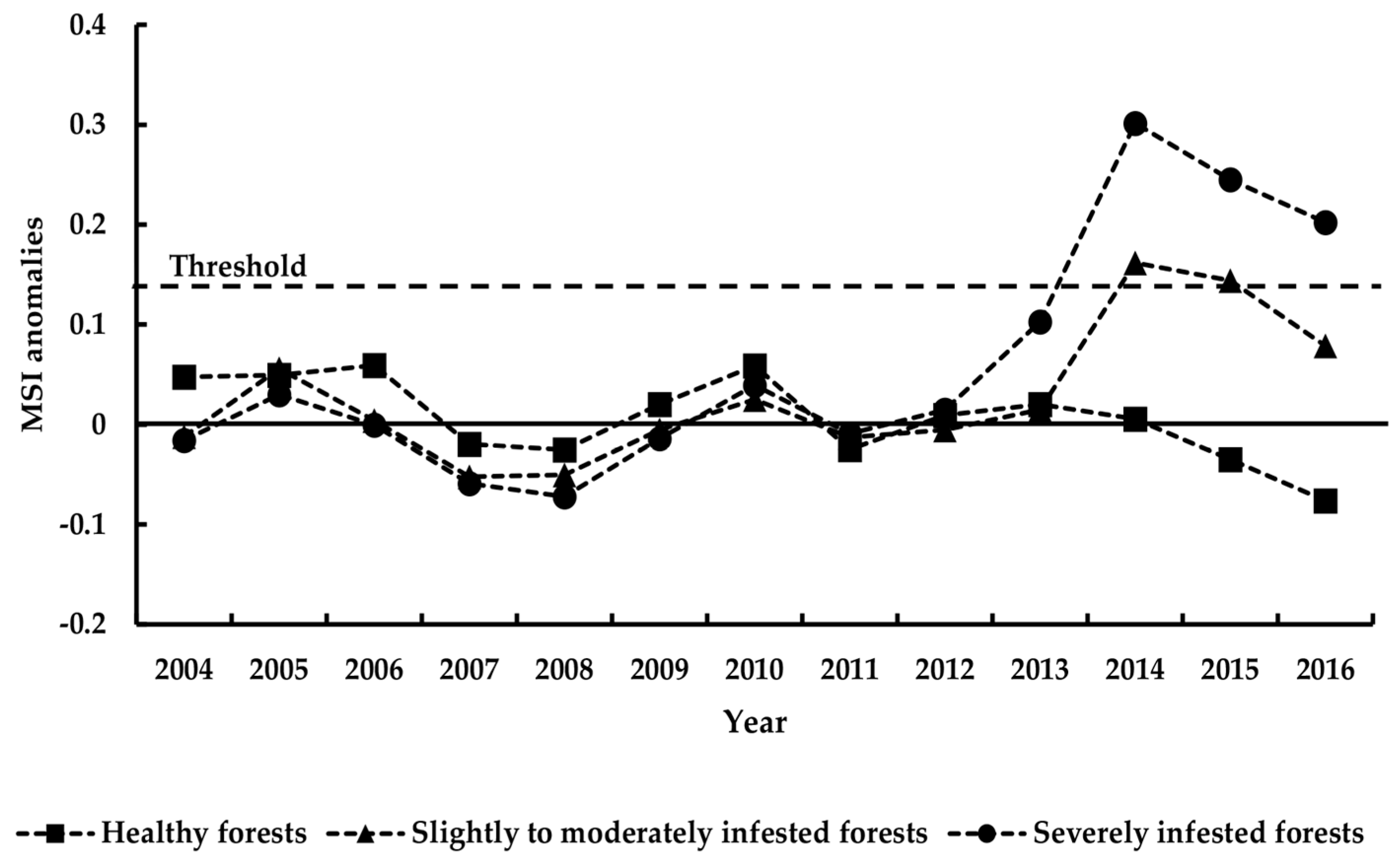
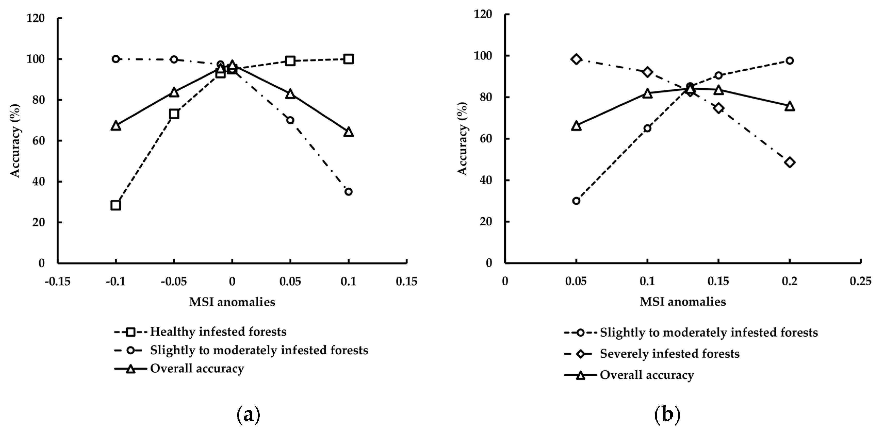
Classification using MSI produced the highest accuracy for the multi-date approach. MSI is sensitive to water content and, thus, drought. As such, it is highly related to the weakness or vulnerability of the Yunnan pine. This can explain the good performance of MSI. However, the accuracy varies with SDR. High classification accuracies were obtained for high SDRs within pixels, however, there was low accuracy for lower SDRs. Our findings indicate the usefulness of multi-date Landsat imagery for detecting severe beetle disturbance (i.e., SDR > 50% within a pixel). However, there is still difficulty in accurately differentiating slightly to moderately infested forests (i.e., 10% ≤ SDR ≤ 50% within a pixel).
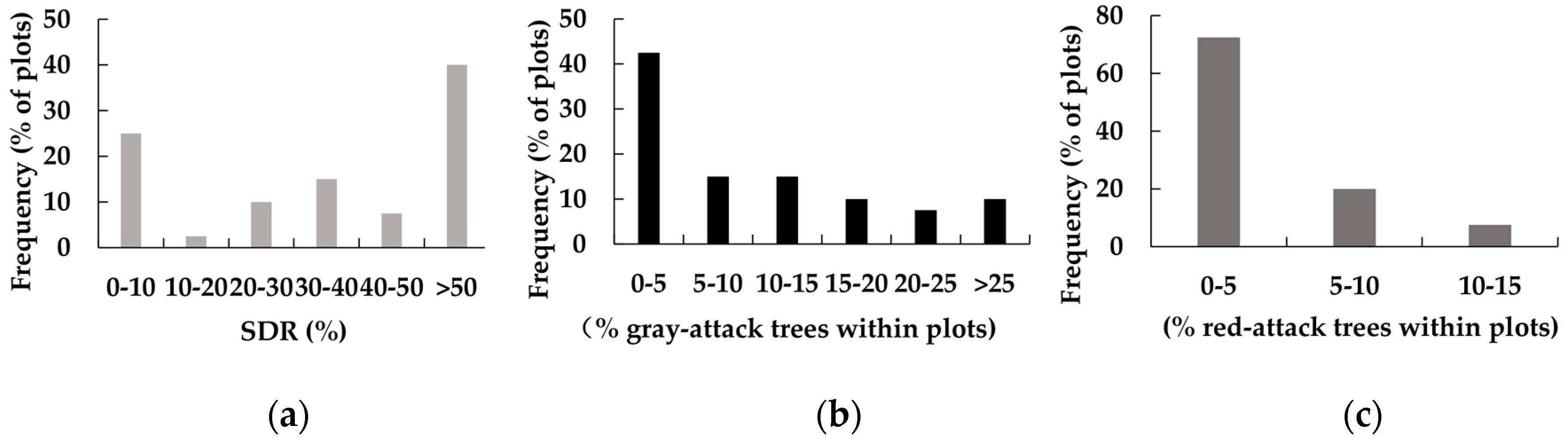
SDR is a good indicator for detecting forest disturbances caused by the beetles. Meddens et al. [
45] found that Landsat is useful for detecting severe tree mortality (i.e., death of more than approximately 25% of trees in the canopy within a pixel) but cannot detect slowly progressing disturbances within a pixel (i.e., as fewer than 25% red trees at any one time) with high accuracy. In our 40 permanent field plots, tree mortality (gray-attack trees) of more than 25% in the canopy within a pixel account for 10% of plots, and red-attack trees of >10% within a pixel also account for less than 10% of plots. Thus, if we use gray-attack or red-attack tree percentages to reflect the damage degrees of forests, the detection accuracies would be low. According to the research of Meddens et al. [
45] and the special damage characteristics of the beetles, we chose the SDR to define the damage degrees instead of tree mortality.
Our methods use a time window from November to December to detect beetle disturbance. This is different from previous studies which use the middle of the growing season (July or August) as a time window [
45,
56,
57]. A major reason for this is (1) the two stages of the life cycle for shoot beetles. They attack shoots from May to November, thus, the number of damaged shoots enters a rising trend in this time periods. The amount of shoot damage would reach its maximum peak sometime in November to December. After that, these beetles begin to transfer from the shoot to the trunks of trees. The color of the damage shoots would turn from green to red in November–December. This largely influences spectral reflectance, making it easier for RS to detect. Another major reason is (2) climate. Our study area has a clear dry and wet season. The rainy season is from June to October, which is within the growing season. The significant cloud cover during July and August is not good for optical remote sensing.
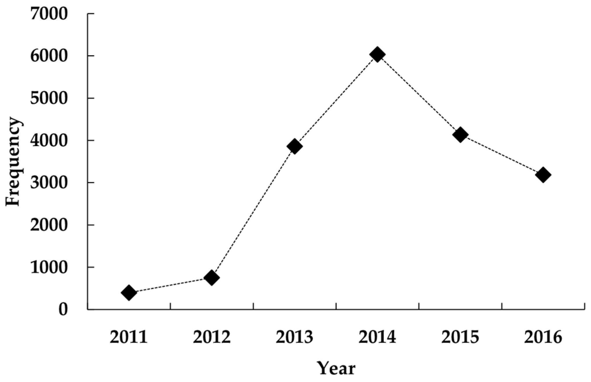
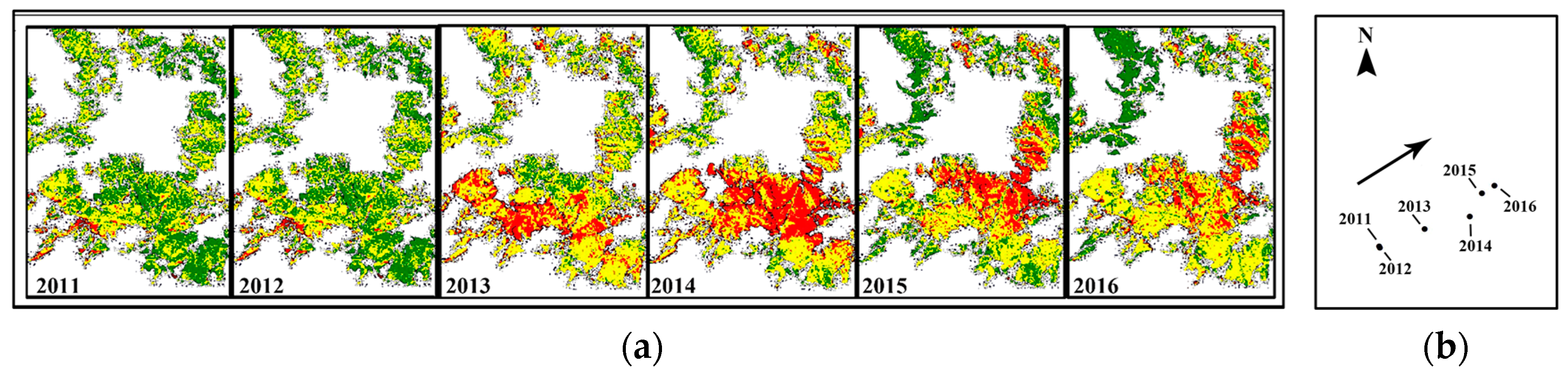
Lacking historical monitoring data, it was difficult to study the previous and current state of the forests. In this study, we utilized multi-date Landsat imagery and successfully predicted the outbreak year (i.e., 2013) and reconstructed the locations of severely infested forests from 2011 to 2016. Although we could not truly evaluate the accuracy of beetle-disturbed regions before 2016, our study could detect the beetle disturbance to some degree, especially in severely infested forests. This method will be useful for similar regions without historical records.
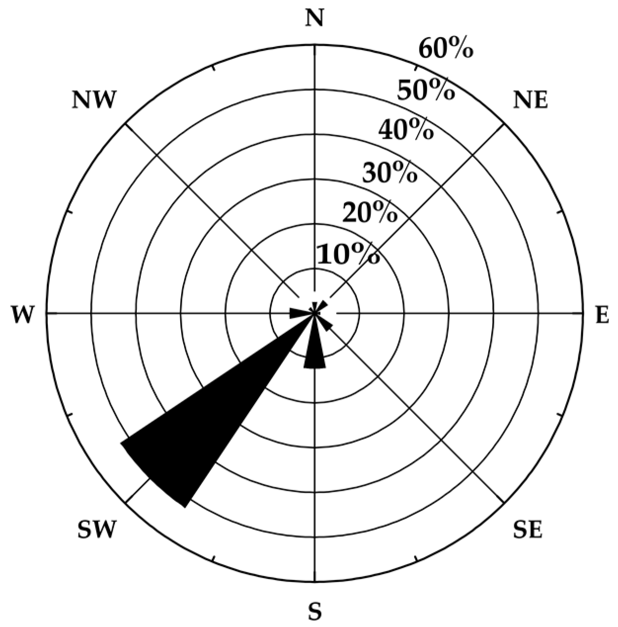
Another interesting finding is that shoot beetles moved from the southwest to northeast direction from 2011 to 2016. Based on previous research, MPBs attack surrounding injured or diseased trees stressed by moisture limitation or disturbances during the period in that spot growth or areas within 2 km [
58,
59,
60]. Additionally, MPBs are transported long distances by the wind [
61]. Because
T. yunnanensis and
T. minor transfer between shoots during the shoot-feeding time period, their time exposed to air would be longer than MPBs. Ye et al. [
39] found that the spread of
T. piniperda was also greatly influenced by the wind. The number of beetles downwind of the bole mass of the attacked tree were greater than that upwind. This shows that wind is a vector for spread. In our study, the movement of the center of the severely infested forests from 2011 to 2016 was more than 2 km. Combining our findings with previous research, we speculate wind to be a vector for long-distance dispersal of
Tomicus spp.
The rising and decreasing trends of severely infested forests from 2011 to 2016 appears strange. The major reasons for this include climate and human factors. Since 2009, widespread drought (i.e., the average annual precipitation from 2010 to 2014 was 810 mm) in Yunnan Province weakened trees, making it suitable for beetles to attack trunks. However, the precipitation rose after 2014 (i.e., the average annual precipitation from 2015 to 2016 was 1085 mm), which increased the resistance of Yunnan pine to beetles. This could partially explain the declining trend of pixels of severely infested forest from 2014 to 2016. Harvesting is the main human activity affecting this trend. During the investigation time, we found that villagers harvested infested trees to use as fire-wood, especially the red-attack trees which contain numerous adult beetles. This behavior reduced beetle density and the area of severely infested forests. However, further research needs to determine the other specific drivers of beetle spread besides wind.


