Assessing Spatial Equity and Accessibility of Public Green Spaces in Aleppo City, Syria


Abstract
:1. Introduction
- Are urban green spaces in Aleppo distributed dispersed, random or clustered? (Proximity)
- Which are areas of low and high coverage of urban green spaces? (Quantity/Acreage)
- How accessible are urban green spaces to inhabitants? (Proximity)
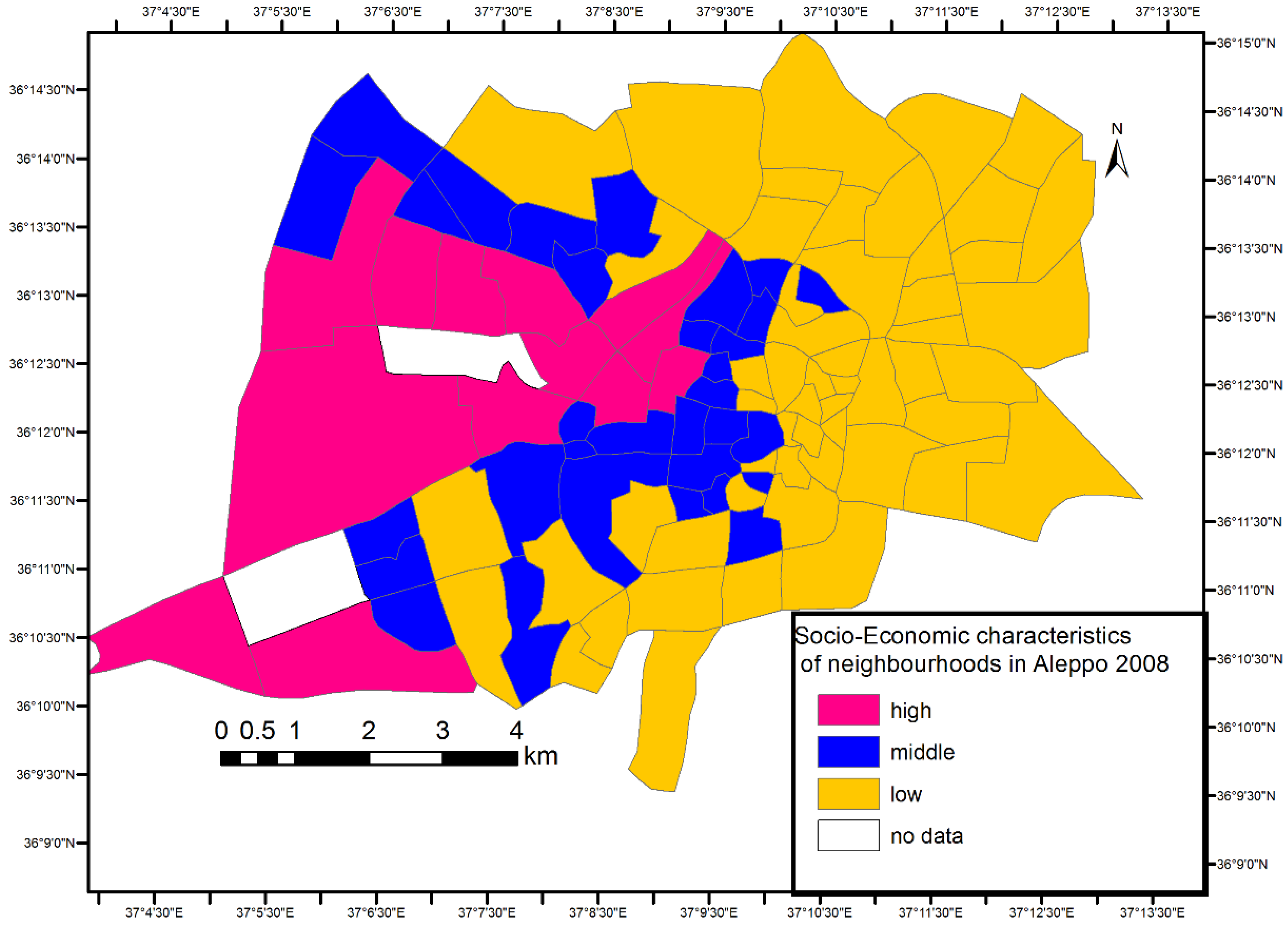
- How are urban green spaces distributed in relation to the socioeconomic status of the neighbourhoods? (Quantity/Acreage)
2. Materials and Methods
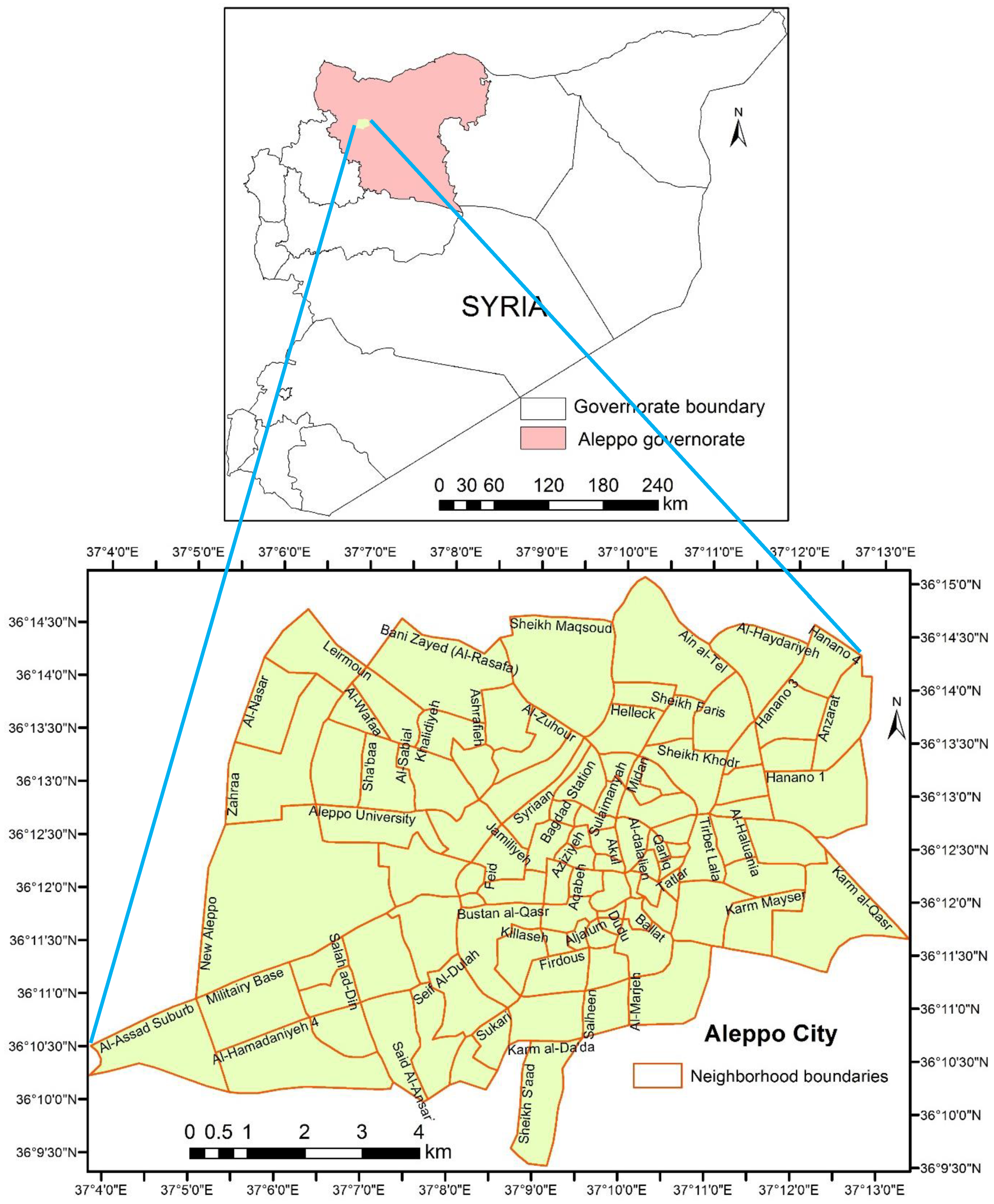
2.1. Study Area
2.2. Data and Methods
2.3. Establishing the Categorization of Urban Parks
2.4. The Average Nearest Neighbour
2.5. Parks Facilities Under and Over Coverage
2.6. Network Analysis
2.7. One-Way ANOVA Test and Post-Hoc Tukey HSD Test
3. Results and Discussion
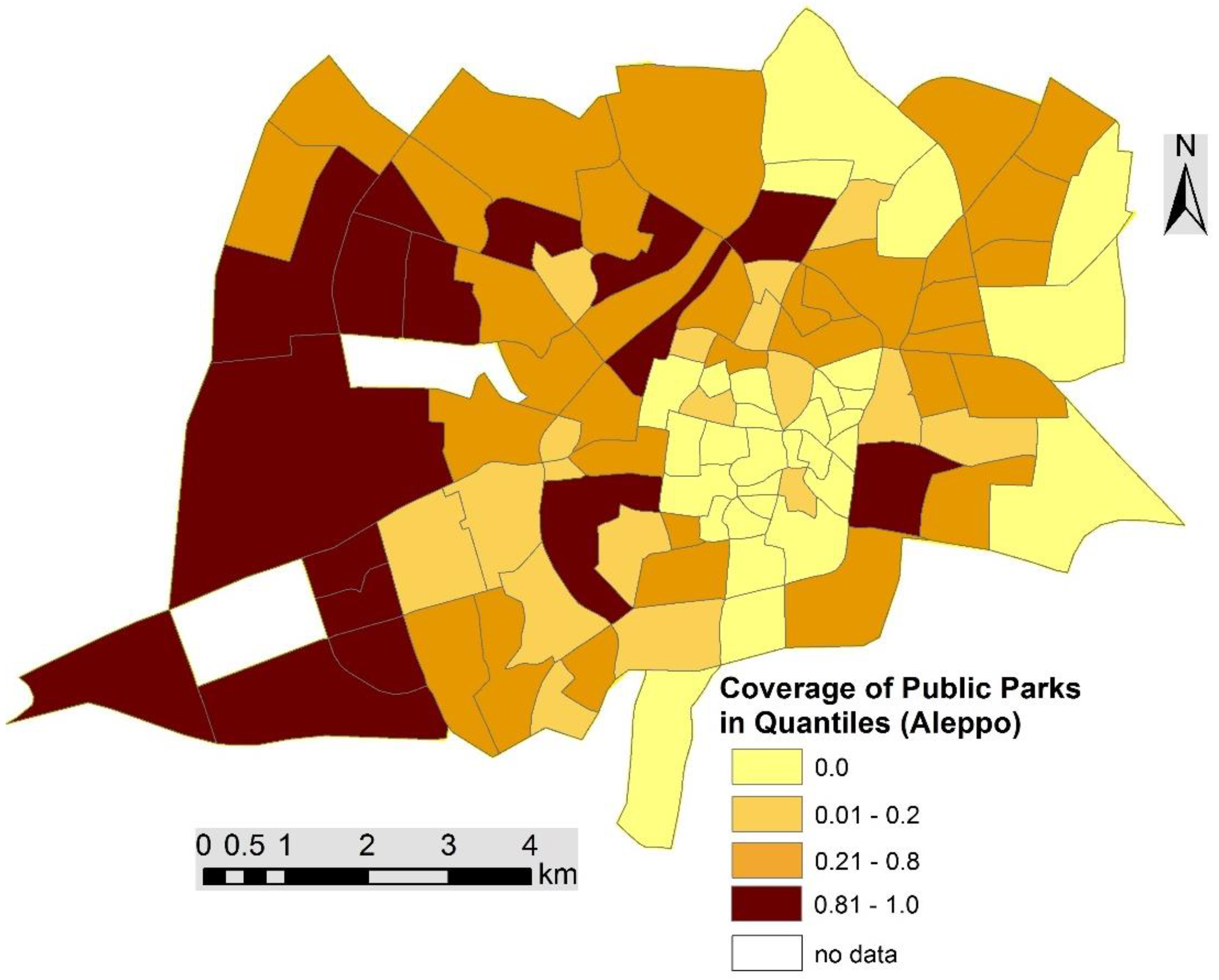
3.1. Public Parks Distribution and Spatial Equity
3.2. Facilities Under- and Over- Coverage
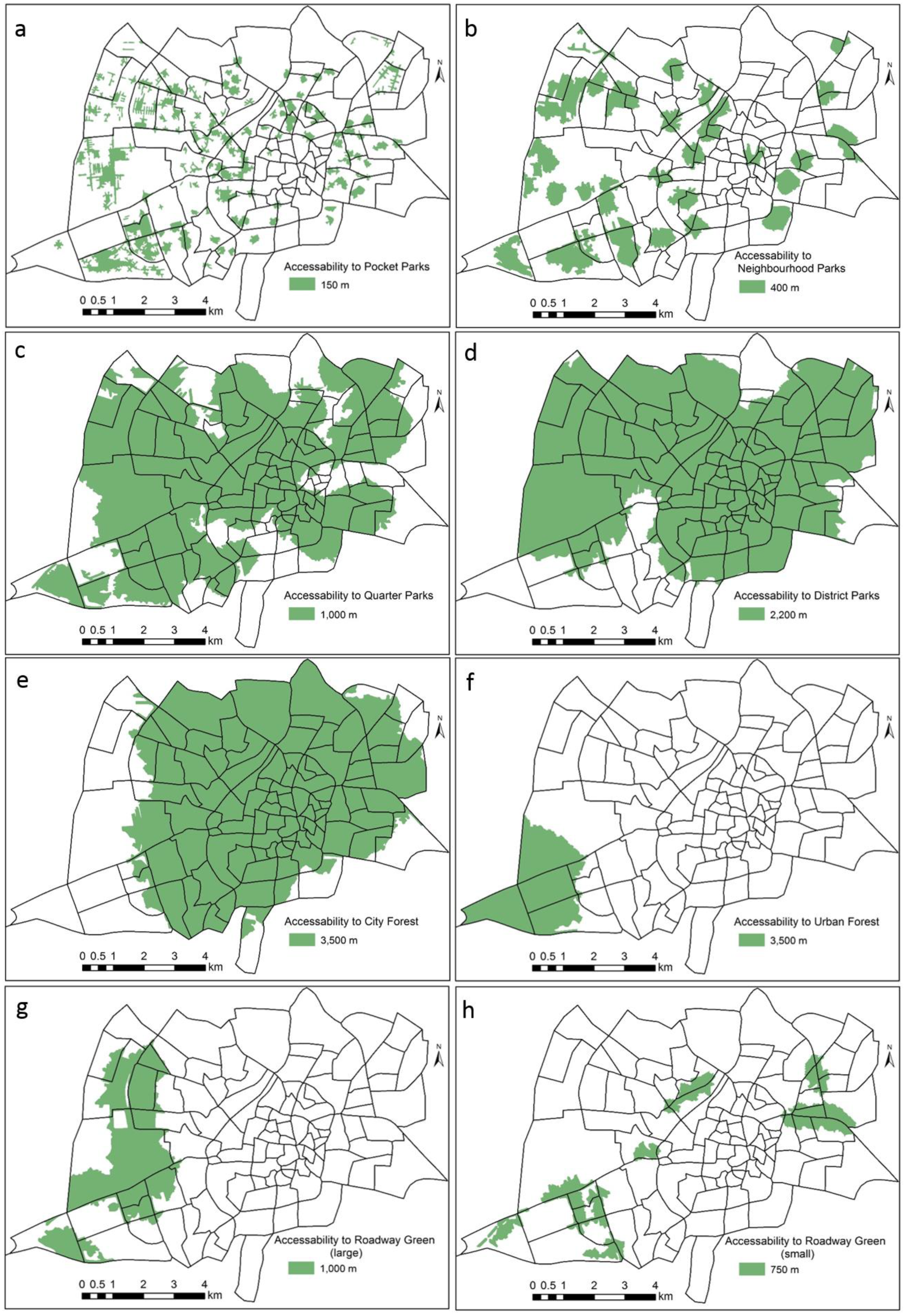
3.3. Network Analysis
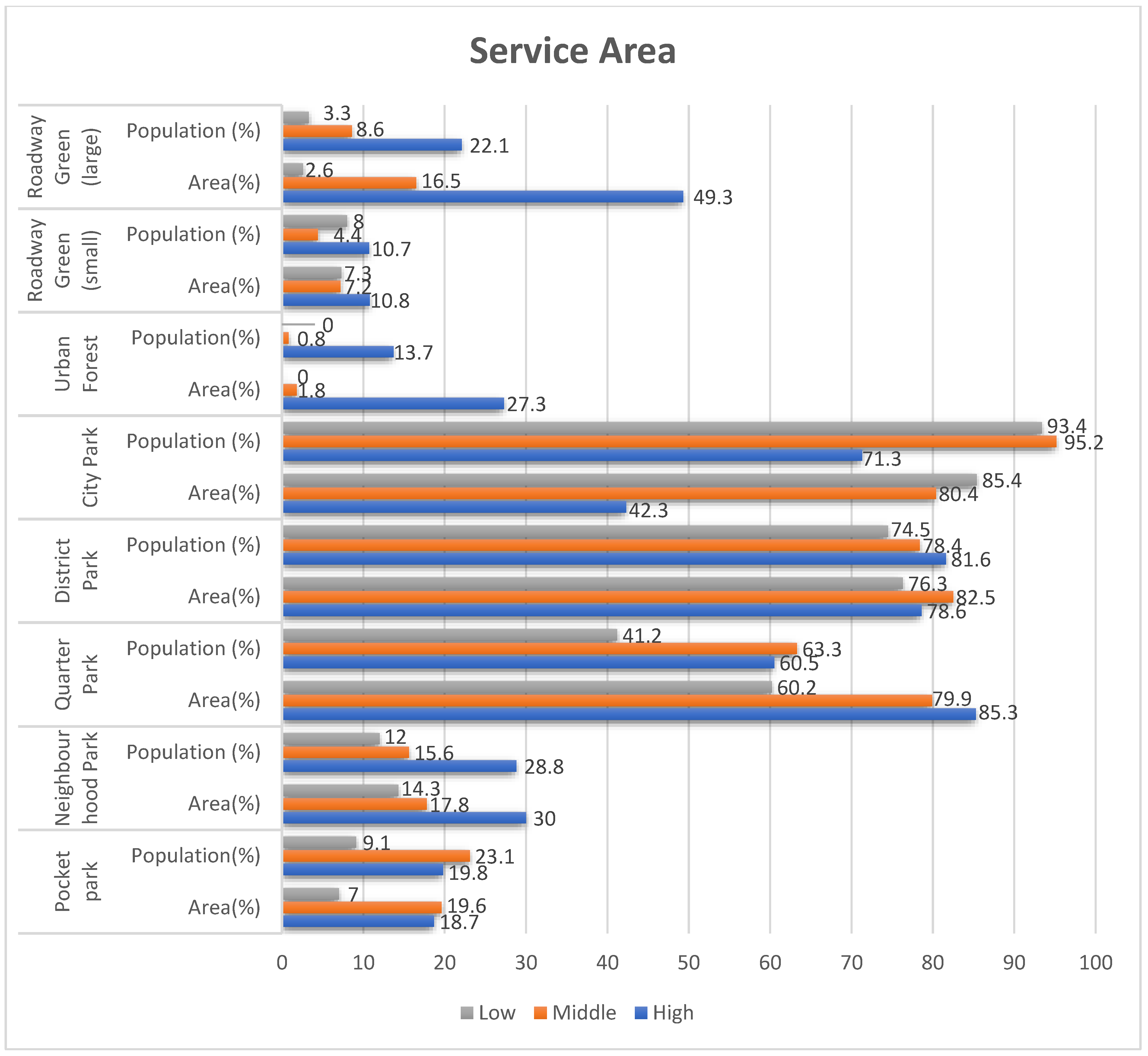
3.4. One-Way ANOVA Test and Post-Hoc Tukey HSD Test
- Most of the population (85%) lack access to pocket parks within 150 m.
- 60%–80% of residents lack access to neighbourhoods parks within 1000 m.
- Most people have access to the quarter parks, district parks and city parks within 3500 m.
- Low-income groups have significantly less access to most public city parks than high-income groups, except in the category of city parks.
4. Conclusions
Author Contributions
Funding
Acknowledgments
Conflicts of Interest
References and Notes
- Macedo, J.; Haddad, M.A. Equitable distribution of open space: Using spatial analysis to evaluate urban parks in Curitiba, Brazil. Environ. Plan. B Plan. Des. 2016, 43, 1096–1117. [Google Scholar] [CrossRef]
- Yuan, Y.; Xu, J.; Wang, Z. Spatial equity measure on urban ecological space layout based on accessibility of socially vulnerable groups-A case study of Changting, China. Sustainability 2017, 9, 1–20. [Google Scholar] [CrossRef]
- Unal, M.; Uslu, C. Evaluating and Optimizing Urban Green Spaces for Compact Urban Areas: Cukurova District in Adana, Turkey. Int. J. Geo-Inf. 2018, 7, 70. [Google Scholar] [CrossRef]
- German Technical Cooperation (GTZ) Syrian—German Development Cooperation Program for Sustainable Urban Development in Syria Aleppo Urban Development Project “Notes on a proposed Policy & Implementation Strategies for Informal Settlements” By: Patrick Wakely on behalf of Aleppo Urban D; Damascus and Columbus, 2010.
- La Rosa, D. Accessibility to greenspaces: GIS based indicators for sustainable planning in a dense urban context. Ecol. Indic. 2014, 42, 122–134. [Google Scholar] [CrossRef]
- Tu, X.; Huang, G.; Wu, J. Contrary to common observations in the west, urban park access is only weakly related to neighborhood socioeconomic conditions in Beijing, China. Sustainability 2018, 10, 1115. [Google Scholar] [CrossRef]
- Bertram, C.; Rehdanz, K. The role of urban green space for human well-being. Ecol. Econ. 2015, 120, 139–152. [Google Scholar] [CrossRef] [Green Version]
- De La Barrera, F.; Reyes-Paecke, S.; Banzhaf, E. Indicators for green spaces in contrasting urban settings. Ecol. Indic. 2016, 62, 212–219. [Google Scholar] [CrossRef]
- Cetin, M. Using GIS analysis to assess urban green space in terms of accessibility: Case study in Kutahya. Int. J. Sustain. Dev. World Ecol. 2015, 22, 420–424. [Google Scholar] [CrossRef]
- Talen, E. Neighborhoods as service providers: A methodology for evaluating pedestrian access. Environ. Plan. B Plan. Des. 2003, 30, 181–200. [Google Scholar] [CrossRef]
- Rigolon, A.; Browning, M.; Lee, K.; Shin, S. Access to urban green space in cities of the global south: A systematic literature review. Urban Sci. 2018, 2, 67. [Google Scholar] [CrossRef]
- Rigolon, A. A complex landscape of inequity in access to urban parks: A literature review. Landsc. Urban Plan. 2016, 153, 160–169. [Google Scholar] [CrossRef]
- Konijnendijk, C.C.; Annerstedt, M.; Nielsen, A.B.; Maruthaveeran, S. Benefits of Urban Parks—A systematic review. Int. Fed. Park. Recreat. Adm. 2013, 1–68. [Google Scholar]
- Van Herzele, A.; Wiedemann, T. A monitoring tool for the provision of accessible and attractive urban green spaces. Landsc. Urban Plan. 2003, 63, 109–126. [Google Scholar] [CrossRef]
- Haaland, C.; van den Bosch, C.K. Challenges and strategies for urban green-space planning in cities undergoing densification: A review. Urban For. Urban Green. 2015, 14, 760–771. [Google Scholar] [CrossRef]
- Jennings, V.; Johnson Gaither, C.; Gragg, R.S. Promoting Environmental Justice Through Urban Green Space Access: A Synopsis. Environ. Justice 2012, 5, 1–7. [Google Scholar] [CrossRef]
- Akpinar, A. How is quality of urban green spaces associated with physical activity and health? Urban For. Urban Green. 2016, 16, 76–83. [Google Scholar] [CrossRef]
- Wolch, J.R.; Byrne, J.; Newell, J.P. Urban green space, public health, and environmental justice: The challenge of making cities “just green enough”. Landsc. Urban Plan. 2014, 125, 234–244. [Google Scholar] [CrossRef]
- Margaritis, E.; Kang, J. Relationship between urban green spaces and other features of urban morphology with traffic noise distribution. Urban For. Urban Green. 2016, 15, 174–185. [Google Scholar] [CrossRef] [Green Version]
- Boone, C.G.; Buckley, G.L.; Grove, J.M.; Sister, C. Parks and People: An environmental justice inquiry in baltimore, Maryland. Ann. Assoc. Am. Geogr. 2009, 99, 767–787. [Google Scholar] [CrossRef]
- Campbell, S. Green Cities, Growing Cities, Just Cities? Urban Planning and the Contradictions of Sustainable Development. J. Am. Plan. Assoc. 1996, 62, 296–312. [Google Scholar] [CrossRef]
- Wolch, J.; Wilson, J.P.; Fehrenbach, J. Parks and park funding in Los Angeles: An equity-mapping analysis. Urban Geogr. 2005, 26, 4–35. [Google Scholar] [CrossRef]
- Schlosberg, D. Reconceiving environmental justice: Global movements and political theories. Environ. Polit. 2004, 13, 517–540. [Google Scholar] [CrossRef]
- Unal, M.; Uslu, C.; Cilek, A. GIS-based accessibility analysis for neighbourhood Parks: The case of cukurova district modelling accessibility to urban greenspaces. J. Digit. Landsc. Archit. 2016, 1, 46–56. [Google Scholar] [CrossRef]
- Germann-Chiari, C.; Seeland, K. Are urban green spaces optimally distributed to act as places for social integration? Results of a geographical information system (GIS) approach for urban forestry research. For. Policy Econ. 2004, 6, 3–13. [Google Scholar] [CrossRef]
- Rojas, C.; Páez, A.; Barbosa, O.; Carrasco, J. Accessibility to urban green spaces in Chilean cities using adaptive thresholds. J. Transp. Geogr. 2016, 57, 227–240. [Google Scholar] [CrossRef]
- Taylor, B.T.; Fernando, P.; Bauman, A.E.; Williamson, A.; Craig, J.C.; Redman, S. Measuring the quality of public open space using google earth. Am. J. Prev. Med. 2011, 40, 105–112. [Google Scholar] [CrossRef] [PubMed]
- Oh, K.; Jeong, S. Assessing the spatial distribution of urban parks using GIS. Landsc. Urban Plan. 2007, 82, 25–32. [Google Scholar] [CrossRef]
- Gupta, K.; Roy, A.; Luthra, K.; Maithani, S.; Mahavir. GIS based analysis for assessing the accessibility at hierarchical levels of urban green spaces. Urban For. Urban Green. 2016, 18, 198–211. [Google Scholar] [CrossRef]
- Programme for sustainable Urban Development UDP Informal settlements in aleppo: RAPID PROFILES OF ALL INFORMAL SETTLEMENTS IN ALEPPO; Aleppo, 2008.
- Central Bureau of Statistics Number of Population and Families by Urban and Rural 2004. Available online: http://cbssyr.sy/General census/census 2004/pop-man.pdf (accessed on 30 May 2017).
- UN-HABITAT City Profile Aleppo. Multi Sector Assessment; Damascus, 2014.
- Aleppo Governorate Council service for spatial data of Aleppo Governorate Council; Aleppo, 2016.
- Kounadi, O. Assessing the Quality of OpenStreetMap Data. Master’s Thesis, University College of London, London, UK, 2009. [Google Scholar]
- Ather, A. A Quality Analysis of Open Street Map Data. Master’s Thesis, University College London, London, UK, May 2009. [Google Scholar]
- Wang, M.; Li, Q.; Hu, Q.; Zhou, M. Quality analysis of open street map data. ISPRS Int. Arch. Photogramm. Remote Sens. Spat. Inf. Sci. 2013, 40, 155–158. [Google Scholar] [CrossRef]
- Open Street Map Data Quality. Available online: http://osmlab.github.io/osm-data-quality/ (accessed on 20 October 2018).
- Balooni, K.; Gangopadhyay, K.; Kumar, B.M. Governance for private green spaces in a growing Indian city. Landsc. Urban Plan. 2014, 123, 21–29. [Google Scholar] [CrossRef]
- Wright Wendel, H.E.; Zarger, R.K.; Mihelcic, J.R. Accessibility and usability: Green space preferences, perceptions, and barriers in a rapidly urbanizing city in Latin America. Landsc. Urban Plan. 2012, 107, 272–282. [Google Scholar] [CrossRef]
- Central Bureau of Statistics CBS-SY. Available online: http://www.cbssyr.sy/index-EN.htm (accessed on 7 August 2017).
- Municipality of Aleppo; Aleppo, 2009.
- Municipality of Aleppo; Aleppo, 2012.
- Winkleby, M.A.; Jatulis, D.E.; Frank, E.; Fortmann, S.P. Socioeconomic status and health: How education, income, and occupation contribute to risk factors for cardiovascular disease. Am. J. Public Health 1992, 82, 816. [Google Scholar] [CrossRef] [PubMed]
- Singh, T.; Sharma, S.; Nagesh, S. Socio-economic status scales updated for 2017. Int. J. Res. Med. Sci. 2017, 5, 3264. [Google Scholar] [CrossRef] [Green Version]
- Hashem, N. Assessing spatial equality of urban green spaces provision: A case study of Greater Doha in Qatar. Local Environ. 2015, 20, 386–399. [Google Scholar] [CrossRef]
- Handley, J.; Pauleit, S.; Slinn, P.; Lindley, S.; Baker, M.; Barber, A.; Jones, C. Providing accessible natural greenspace in towns and cities: A practical guide to assessing the resource and implementing local standards for provision. Rep. Nat. Engl. 2003, 1–36. [Google Scholar] [CrossRef]
- Breuste, J.; Rahimi, A. Many public urban parks, but who profits from them? The example of Tabriz, Iran. Ecol. Process. 2015, 4, 6. [Google Scholar] [CrossRef]
- ESRI (Environmental Systems Research Institute) How Average Nearest Neighbor Distance (Spatial Statistics) Works. Available online: http://resources.esri.com/help/9.3/ArcGISDesktop/com/Gp_ToolRef/spatial_statistics_tools/how_average_nearest_neighbor_distance_spatial_statistics_works.htm (accessed on 31 May 2017).
- IB Geography Nearest Neighbor Index. Available online: http://www.geoib.com/nearest-neighbor-index.html (accessed on 31 May 2017).
- Mansour, S. Spatial analysis of public health facilities in Riyadh governorate, Saudi Arabia: A GIS-based study to assess geographic variations of service provision and accessibility. Geo-spatial Inf. Sci. 2016, 19, 26–38. [Google Scholar] [CrossRef]
- Schwanke Khilji, S.U.; Rudge, J.W.; Drake, T.; Chavez, I.; Borin, K.; Touch, S.; Coker, R. Distribution of selected healthcare resources for influenza pandemic response in Cambodia. Int. J. Equity Health 2013, 12, 82. [Google Scholar] [CrossRef] [PubMed] [Green Version]
- Li, H.; Chen, W.; He, W. Planning of green space ecological network in urban areas: An example of Nanchang, China. Int. J. Environ. Res. Public Health 2015, 12, 12889–12904. [Google Scholar] [CrossRef] [PubMed]
- Siragusa, A.; Pafi, M.; Ferri, S.; Halkia, S. Measuring the Accessibility of Urban Green Areas: A Comparison of the Green ESM with other Datasets in Four European Cities Measuring the Accessibility of Urban Green Areas a Comparison of the Green; JRC Technical Reports; Joint Research Centre: Ispra, Italy, 2016; ISBN 9789279612862. [Google Scholar]
- So, S.W. Urban Green Space Accessibility and Environmental Justice: A GIS-based Analysis in the City of Phoenix, Arizona. Ph.D. Thesis, University of Southern California, Los Angeles, CA, USA, August 2016. [Google Scholar]
- Moseley, D.; Marzano, M.; Chetcuti, J.; Watts, K. Green networks for people: Application of a functional approach to support the planning and management of greenspace. Landsc. Urban Plan. 2013, 116, 1–12. [Google Scholar] [CrossRef]
- Ho, R. Handbook of Univariate and Multivariate Data Analysis and Interpretation with SPSS; Chapman and Hall/CRC.: New York, NY, USA, 2006. [Google Scholar]
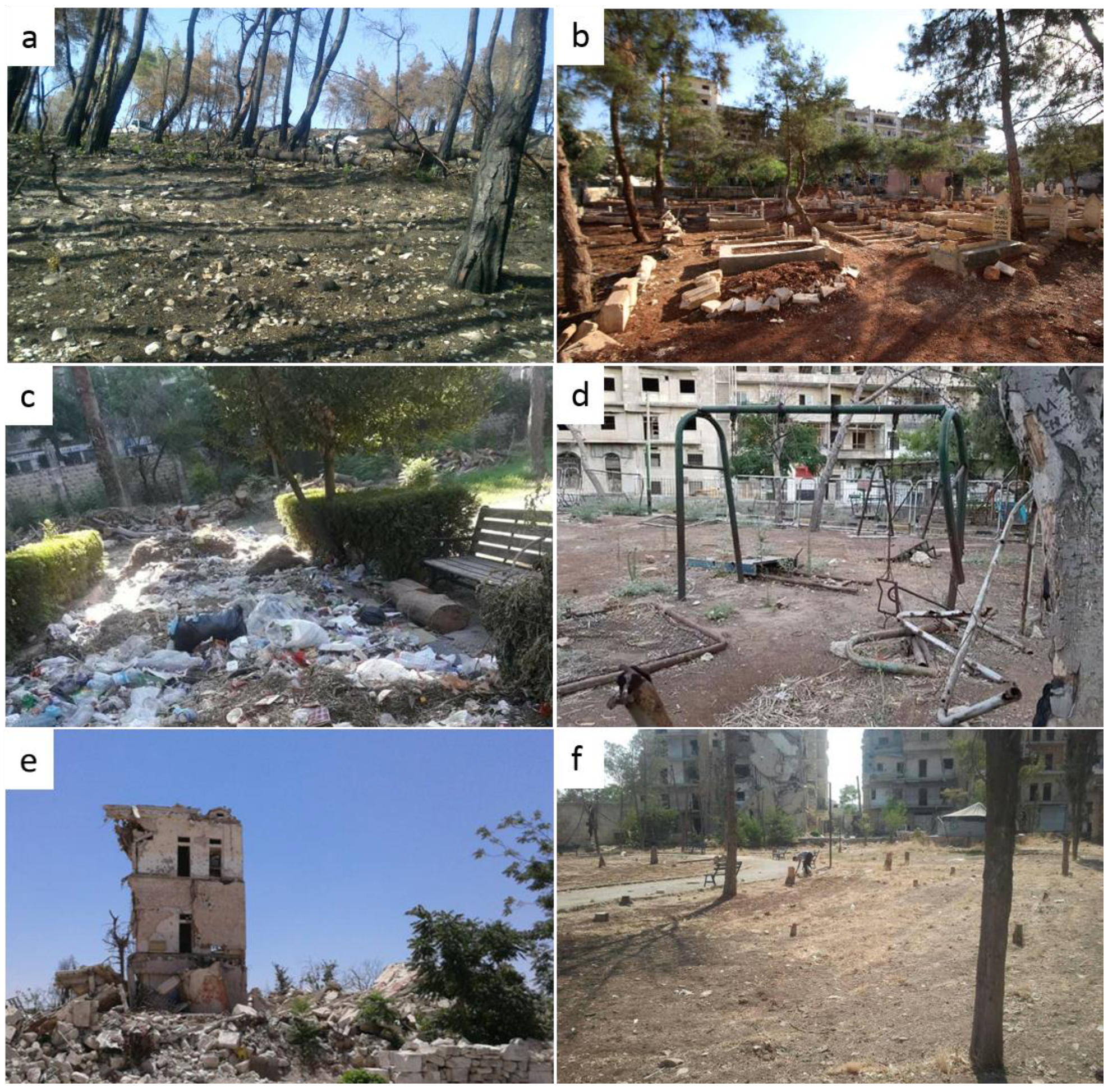
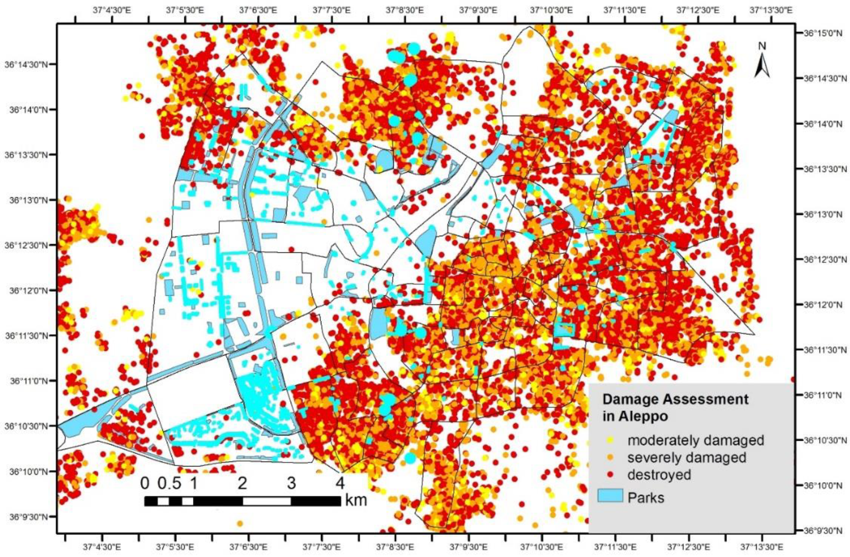
- World Bank Group Syria Damage Assessment of Selected Cities Aleppo, Hama, Idlib; Washington, 2017.
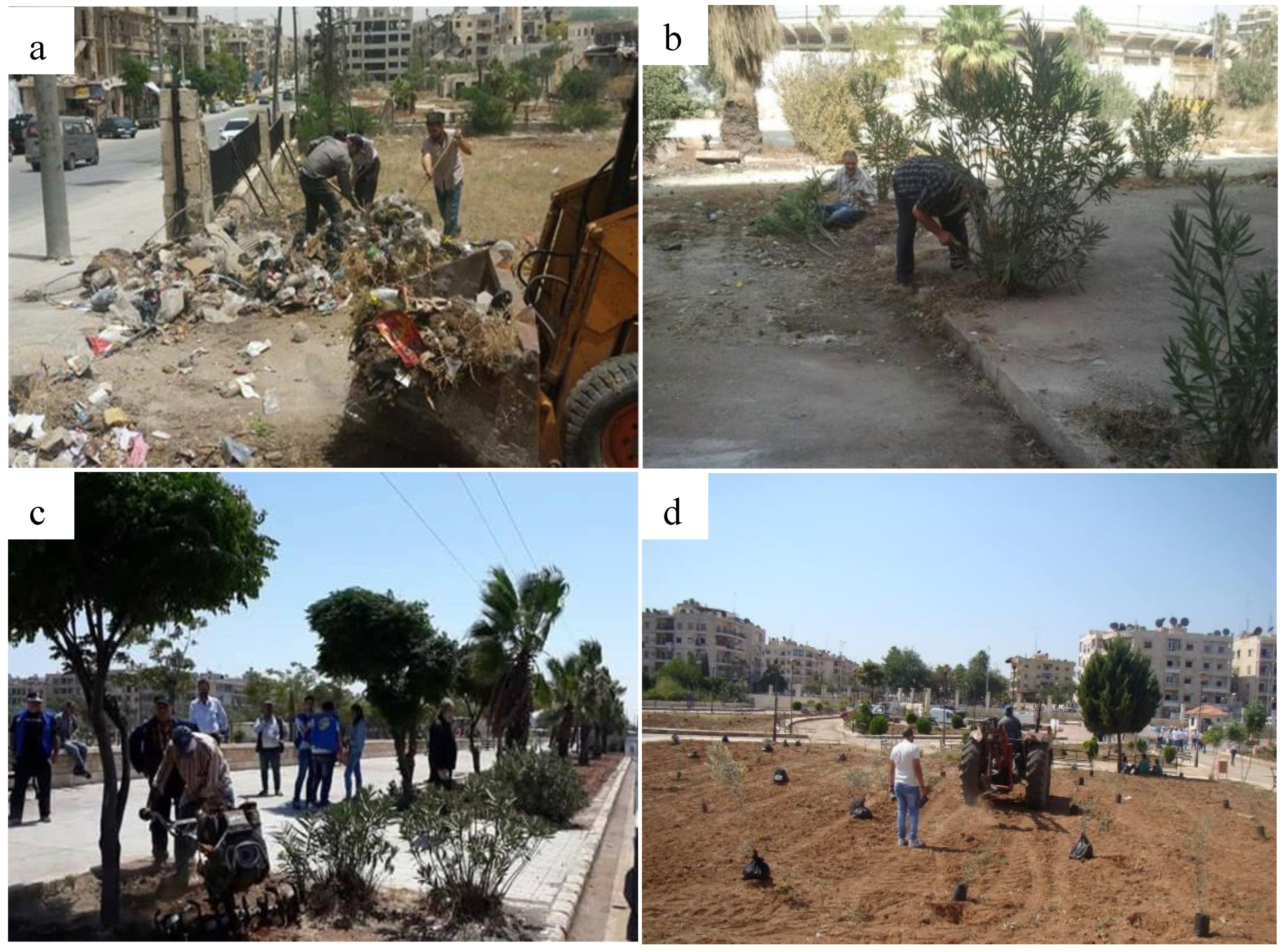
- Asianews Aleppo more Beautiful Christians and Muslims Clean the City. Available online: http://www.asianews.it/news-en/Aleppo-more-beautiful:-Christians-and-Muslims-clean-the-city-41129.html (accessed on 17 October 2018).
- UNHCR Aleppo Slowly Progresses along Road to Recovery. Available online: http://www.unhcr.org/news/latest/2017/5/591480404/aleppo-slowly-progresses-along-road-recovery.html (accessed on 15 October 2018).
- UNITAR-UNOSAT Damage Density in the City of Aleppo 2016.


| Parks | Description | Area (ha) | Max. Dist. From Home |
|---|---|---|---|
| Pocket/Residential park | A very small park which serves the immediately local population. Mostly scattered throughout the city. | <0.5 | <150 m |
| Neighbourhood park | A small park which serves the neighbourhood population. Mostly with playground facilities. | 0.5–1 | 200–500 m |
| Quarter park | A smaller park that serves more than one neighbourhood, but not the city as a whole. Equipped with more recreational facilities. | 1–4 | 500–1200 m |
| District park | A mid-sized park which serves the district as a whole. It provides a range of facilities, such as sport and recreation for various groups of people. | 4–10 | 1200–2500 m |
| City park | A large park which serves as the major recreation- and sport-facility-provider within a city and for its suburbs. | >10 | >3500 m |
| Urban forest | A large area within the boundaries of the city covered by forest serving as recreational space. | >10 | >3500 m |
| Roadway green (small) | Small green space alongside roadways serving as recreational space. | 0.2–5 | <750 m |
| Roadway green (large) | Large green space alongside roadways serving as recreational space. | >5 | 1000–1500 m |
| Socio-Economic | Number of Neighbourhoods | Area | Population | ||||
|---|---|---|---|---|---|---|---|
| Classes | Number | % | km2 | % | Population | % | Population Density (persons/km2) |
| High | 15 | 15.2 | 22.8 | 28.5 | 192,899 | 8.1 | 8448 |
| Middle | 30 | 30.3 | 15.2 | 18.9 | 425,910 | 18 | 28,079 |
| Low | 54 | 54.5 | 42.1 | 52.6 | 1,751,613 | 73.9 | 41,605 |
| Sum | 99 | 100 | 80.1 | 100 | 2,370,422 | 100 | 29,592 |
© 2018 by the authors. Licensee MDPI, Basel, Switzerland. This article is an open access article distributed under the terms and conditions of the Creative Commons Attribution (CC BY) license (http://creativecommons.org/licenses/by/4.0/).
Share and Cite
Almohamad, H.; Knaack, A.L.; Habib, B.M. Assessing Spatial Equity and Accessibility of Public Green Spaces in Aleppo City, Syria. Forests 2018, 9, 706. https://doi.org/10.3390/f9110706
Almohamad H, Knaack AL, Habib BM. Assessing Spatial Equity and Accessibility of Public Green Spaces in Aleppo City, Syria. Forests. 2018; 9(11):706. https://doi.org/10.3390/f9110706
Chicago/Turabian StyleAlmohamad, Hussein, Anna Lisa Knaack, and Badriah Mohammed Habib. 2018. "Assessing Spatial Equity and Accessibility of Public Green Spaces in Aleppo City, Syria" Forests 9, no. 11: 706. https://doi.org/10.3390/f9110706