Spatial Changes of Urban Heat Island Formation in the Colombo District, Sri Lanka: Implications for Sustainability Planning
Abstract
:1. Introduction
2. Materials and Methods
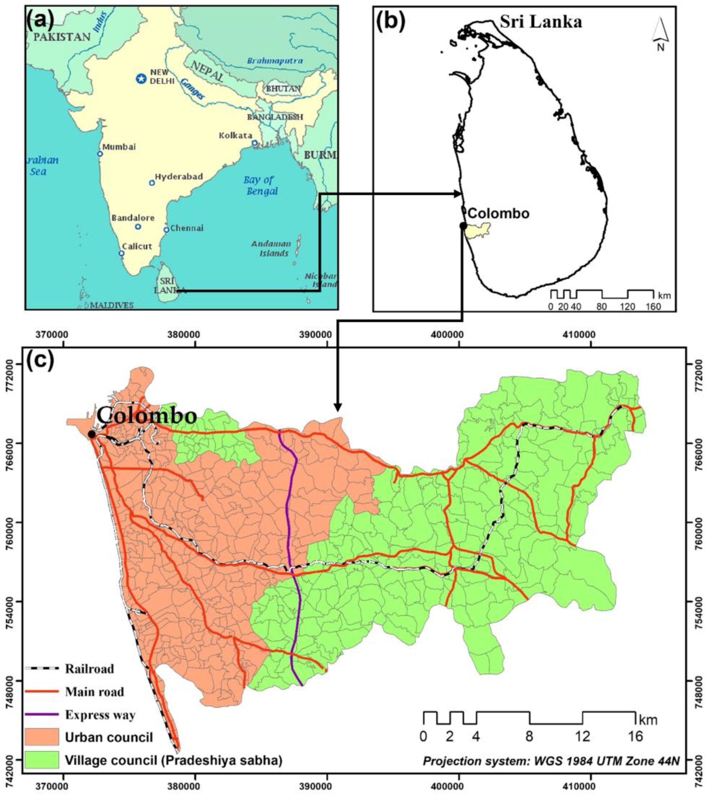
2.1. Study Area: the Colombo District, Sri Lanka
2.2. Satellite Images
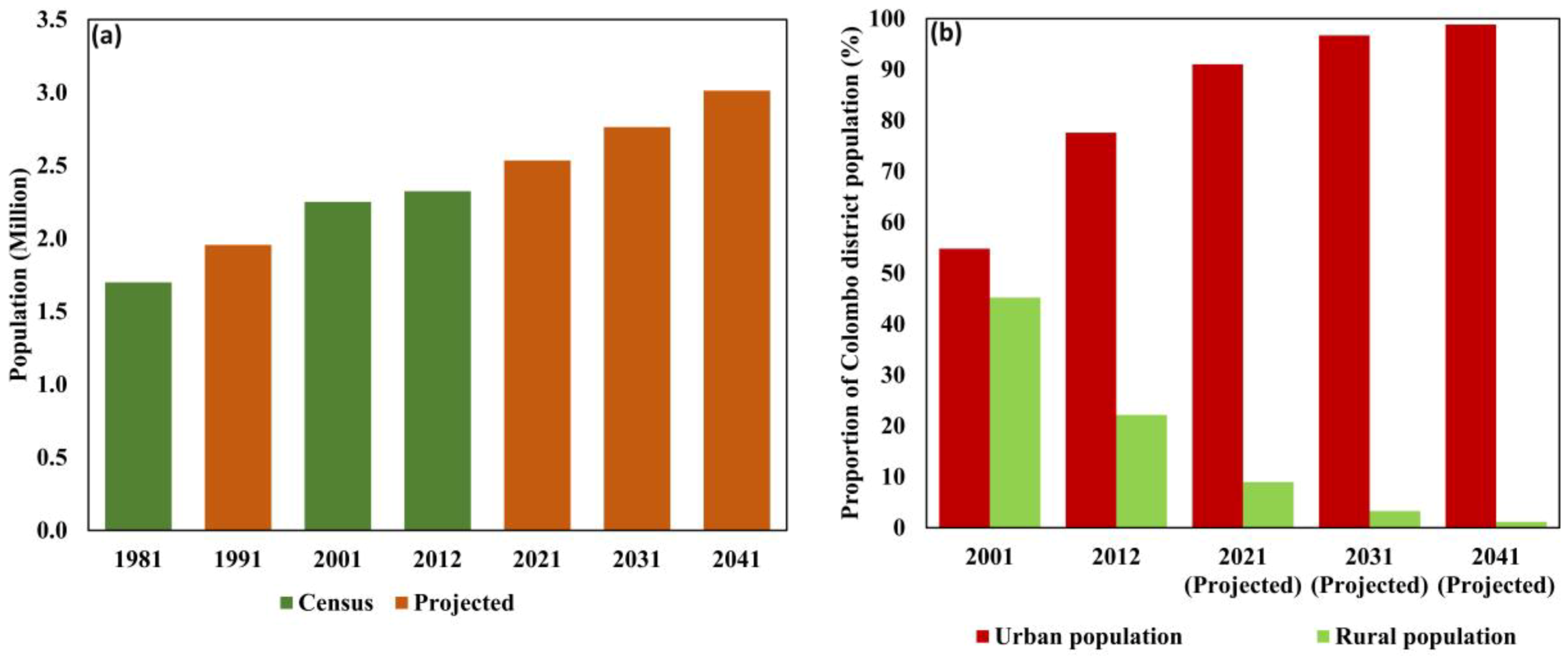
2.3. Population Data
2.4. NDVI Calculation
2.5. NDBI Calculation
2.6. LST Retrieval
2.7. Hot and Cold Spots Analysis
2.8. Spatiotemporal Analysis of Hot and Cold Spots
3. Results
3.1. Mean LST and Its Hot and Cold Spots in 1997 and 2017
3.2. Mean NDVI and Hot and Cold Spots in 1997 and 2017
3.3. Mean NDBI and Its Hot and Cold Spots in 1997 and 2017
3.4. Population Density and Hot and Cold Spots in 1997 and 2017
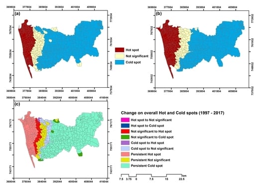
3.5. Changing Pattern of Hot and Cold Spots from 1997 to 2017
4. Discussion
4.1. Spatiotemporal Pattern of Hot and Cold Spots
4.2. Implications for Urban Sustainability
4.3. Limitations of the Study
5. Conclusions
Author Contributions
Acknowledgments
Conflicts of Interest
References
- United Nations (UN). World Urbanization Prospects: The 2014 Revision: Highlights; United Nations: New York, NY, USA, 2015; Volume 12. [Google Scholar]
- Singh, P.; Kikon, N.; Verma, P. Impact of land use change and urbanization on urban heat island in Lucknow city, Central India. A remote sensing based estimate. Sustain. Cities Soc. 2017, 32, 100–114. [Google Scholar] [CrossRef]
- Estoque, R.C.; Murayama, Y.; Myint, S.W. Science of the Total Environment Effects of landscape composition and pattern on land surface temperature: An urban heat island study in the megacities of Southeast Asia. Sci. Total Environ. 2017, 577, 349–359. [Google Scholar] [CrossRef] [PubMed]
- Ranagalage, M.; Estoque, R.C.; Murayama, Y. An Urban Heat Island Study of the Colombo Metropolitan Area, Sri Lanka, Based on Landsat Data (1997–2017). ISPRS Int. J. Geo-Inf. 2017, 6, 189. [Google Scholar] [CrossRef]
- Zhang, X.; Estoque, R.C.; Murayama, Y. An urban heat island study in Nanchang City, China based on land surface temperature and social-ecological variables. Sustain. Cities Soc. 2017, 32, 557–568. [Google Scholar] [CrossRef]
- Voogt, J.A. Urban Heat Islands Cities, 2004. Available online: http:// www. actionbioscience.org/environment/voogt.html (accessed on 5 March 2018).
- US Environmental Protection Agency (EPA). Reducing Urban Heat Islands: Compendium of Strategies Urban Heat Island Basics; US Environmental Protection Agency: Washington, DC, USA, 2009.
- Myint, S.W.; Wentz, E.A.; Brazel, A.J.; Quattrochi, D.A. The impact of distinct anthropogenic and vegetation features on urban warming. Landsc. Ecol. 2013, 28, 959–978. [Google Scholar] [CrossRef]
- Tran, D.X.; Pla, F.; Latorre-Carmona, P.; Myint, S.W.; Caetano, M.; Kieu, H.V. Characterizing the relationship between land use land cover change and land surface temperature. ISPRS J. Photogramm. Remote Sens. 2017, 124, 119–132. [Google Scholar] [CrossRef]
- Estoque, R.C.; Murayama, Y. Monitoring surface urban heat island formation in a tropical mountain city using Landsat data (1987–2015). ISPRS J. Photogramm. Remote Sens. 2017, 133, 18–29. [Google Scholar] [CrossRef]
- Stathopoulou, M.; Cartalis, C. Daytime urban heat islands from Landsat ETM+ and Corine land cover data: An application to major cities in Greece. Sol. Energy 2007, 81, 358–368. [Google Scholar] [CrossRef]
- Senanayake, I.P.; Welivitiya, W.D.D.P.; Nadeeka, P.M. Remote sensing based analysis of urban heat islands with vegetation cover in Colombo city, Sri Lanka using Landsat-7 ETM+ data. Urban Clim. 2013, 5, 19–35. [Google Scholar] [CrossRef]
- Li, J.; Wang, X.; Wang, X.; Ma, W.; Zhang, H. Remote sensing evaluation of urban heat island and its spatial pattern of the Shanghai metropolitan area, China. Ecol. Complex. 2009, 6, 413–420. [Google Scholar] [CrossRef]
- Li, Y.Y.; Zhang, H.; Kainz, W. Monitoring patterns of urban heat islands of the fast-growing Shanghai metropolis, China: Using time-series of Landsat TM/ETM+ data. Int. J. Appl. Earth Obs. Geoinf. 2012, 19, 127–138. [Google Scholar] [CrossRef]
- Sakakibara, Y.; Owa, K. Urban-rural temperature differences in coastal cities: Influence of rural sites. Int. J. Climatol. 2005, 25, 811–820. [Google Scholar] [CrossRef]
- Myint, S.W.; Brazel, A.; Okin, G.; Buyantuyev, A. Combined Effects of Impervious Surface and Vegetation Cover on Air Temperature Variations in a Rapidly Expanding Desert City. GISci. Remote Sens. 2010, 47, 301–320. [Google Scholar] [CrossRef]
- Chaudhuri, G.; Mishra, N.B. Spatio-temporal dynamics of land cover and land surface temperature in Ganges-Brahmaputra delta: A comparative analysis between India and Bangladesh. Appl. Geogr. 2016, 68, 68–83. [Google Scholar] [CrossRef]
- Rasul, A.; Balzter, H.; Smith, C. Spatial variation of the daytime Surface Urban Cool Island during the dry season in Erbil, Iraqi Kurdistan, from Landsat 8. Urban Clim. 2015, 14, 176–186. [Google Scholar] [CrossRef]
- Tan, M.H.; Li, X.B. Integrated assessment of the cool island intensity of green spaces in the mega city of Beijing. Int. J. Remote Sens. 2013, 34, 3028–3043. [Google Scholar] [CrossRef]
- Wu, H.; Ye, L.-P.; Shi, W.-Z.; Clarke, K.C. Assessing the effects of land use spatial structure on urban heat islands using HJ-1B remote sensing imagery in Wuhan, China. Int. J. Appl. Earth Obs. Geoinf. 2014, 32, 67–78. [Google Scholar] [CrossRef]
- Nichol, J.E.; To, P.H. Temporal characteristics of thermal satellite images for urban heat stress and heat island mapping. ISPRS J. Photogramm. Remote Sens. 2012, 74, 153–162. [Google Scholar] [CrossRef]
- Tsai, P.-J.; Lin, M.-L.; Chu, C.-M.; Perng, C.-H. Spatial autocorrelation analysis of health care hotspots in Taiwan in 2006. BMC Public Health 2009, 9, 464. [Google Scholar] [CrossRef] [PubMed]
- Gajovic, V.; Todorovic, B. Spatial and temporal analysis of fires in Serbia for period 2000–2013. J. Geogr. Inst. Jovan Cvijic SASA 2013, 63, 297–312. [Google Scholar] [CrossRef]
- Rodriguez Lopez, J.M.; Heider, K.; Scheffran, J. Frontiers of urbanization: Identifying and explaining urbanization hot spots in the south of Mexico City using human and remote sensing. Appl. Geogr. 2017, 79, 1–10. [Google Scholar] [CrossRef]
- Yun, S.B.; Yoon, S.H.; Ju, S.; Oh, W.S.; Ma, J.W.; Heo, J. Taxi cab service optimization using spatio-temporal implementation to hot-spot analysis with taxi trajectories. In Proceedings of the 5th ACM SIGSPATIAL International Workshop on Mobile Geographic Information Systems, Burlingame, CA, USA, 2016; pp. 12–18. [Google Scholar]
- Rauner, S.; Eichhorn, M.; Thrän, D. The spatial dimension of the power system: Investigating hot spots of Smart Renewable Power Provision. Appl. Energy 2016, 184, 1038–1050. [Google Scholar] [CrossRef]
- Songchitruksa, P.; Zeng, X. Getis-Ord Spatial Statistics to Identify Hot Spots by Using Incident Management Data. Transp. Res. Rec. J. Transp. Res. Board 2010, 2165, 42–51. [Google Scholar] [CrossRef]
- Li, Z.; Liu, S.; Zhang, X.; West, T.O.; Ogle, S.M.; Zhou, N. Evaluating land cover influences on model uncertainties—A case study of cropland carbon dynamics in the Mid-Continent Intensive Campaign region. Ecol. Modell. 2016, 337, 176–187. [Google Scholar] [CrossRef]
- Wolf, T.; McGregor, G. The development of a heat wave vulnerability index for London, United Kingdom. Weather Clim. Extrem. 2013, 1, 59–68. [Google Scholar] [CrossRef] [Green Version]
- Wasowicz, P. Non-native species in the vascular flora of highlands and mountains of Iceland. PeerJ PrePints 2016, 4, e1559. [Google Scholar] [CrossRef] [PubMed]
- Handayani, H.H.; Estoque, R.C.; Murayama, Y. Estimation of built-up and green volume using geospatial techniques: A case study of Surabaya, Indonesia. Sustain. Cities Soc. 2018, 37, 581–593. [Google Scholar] [CrossRef]
- Das Majumdar, D.; Biswas, A. Quantifying land surface temperature change from LISA clusters: An alternative approach to identifying urban land use transformation. Landsc. Urban Plan. 2016, 153, 51–65. [Google Scholar] [CrossRef]
- ESRI (a). How Hot Spot Analysis (Getis-Ord Gi) Works? 2016. Available online: http://pro.arcgis.com/en/pro-app/tool-reference/spatial-statistics/h-how-hot-spot-analysis-getis-ord-gi-spatial-stati.htm (accessed on 2 March 2018).
- RDA. 2017. Available online: http://www.rda.gov.lk/source/expressways.htm (accessed on 28 February 2018).
- Senanayake, I.P.; Welivitiya, W.D.D.P.; Nadeeka, P.M. Urban green spaces analysis for development planning in Colombo, Sri Lanka, utilizing THEOS satellite imagery—A remote sensing and GIS approach. Urban For. Urban Green. 2013, 12, 307–314. [Google Scholar] [CrossRef]
- Johansson, E.; Emmanuel, R. The influence of urban design on outdoor thermal comfort in the hot, humid city of Colombo, Sri Lanka. Int. J. Biometeorol. 2006, 51, 119–133. [Google Scholar] [CrossRef] [PubMed]
- Herath, D.; Pitawala, A.; Gunatilake, J. Heavy metals in road deposited sediments and road dusts of Colombo Capital, Sri Lanka. J. Natl. Sci. Found. Sri Lanka 2016, 44, 193–202. [Google Scholar] [CrossRef]
- Emmanuel, R.; Johansson, E. Influence of urban morphology and sea breeze on hot humid microclimate: The case of Colombo, Sri Lanka. Clim. Res. 2006, 30, 189–200. [Google Scholar] [CrossRef]
- Department of Census and Statistics. Census of Population and Housing 2012; Key Finding: Colombo, Sri Lanka; Department of Census and Statistics: Colombo, Sri Lanka, 2012. [Google Scholar]
- Department of Census and Statistics, Census of Population and Housing, Department of Census and Statistics: Colombo, Sri Lanka, 2001. Available online: http://www.statistics.gov.lk/PopHouSat/PDF/p7%20 population%20and%20Housing%20Text-11-12-06.pdf (accessed on 28 February 2018).
- Weng, Q.; Lu, D.; Schubring, J. Estimation of land surface temperature-vegetation abundance relationship for urban heat island studies. Remote Sens. Environ. 2004, 89, 467–483. [Google Scholar] [CrossRef]
- Chen, X.L.; Zhao, H.M.; Li, P.X.; Yin, Z.Y. Remote sensing image-based analysis of the relationship between urban heat island and land use/cover changes. Remote Sens. Environ. 2006, 104, 133–146. [Google Scholar] [CrossRef]
- Kumar, D.; Shekhar, S. Statistical analysis of land surface temperature-vegetation indexes relationship through thermal remote sensing. Ecotoxicol. Environ. Saf. 2015, 121, 39–44. [Google Scholar] [CrossRef] [PubMed]
- Orhan, O.; Ekercin, S.; Dadaser-Celik, F. Use of Landsat land surface temperature and vegetation indices for monitoring drought in the Salt Lake Basin Area, Turkey. Sci. World J. 2014, 2014. [Google Scholar] [CrossRef] [PubMed]
- Zhang, Y.; Odeh, I.O.A.; Han, C. Bi-temporal characterization of land surface temperature in relation to impervious surface area, NDVI and NDBI, using a sub-pixel image analysis. Int. J. Appl. Earth Obs. Geoinf. 2009, 11, 256–264. [Google Scholar] [CrossRef]
- Kikon, N.; Singh, P.; Singh, S.K.; Vyas, A. Assessment of urban heat islands (UHI) of Noida City, India using multi-temporal satellite data. Sustain. Cities Soc. 2016, 22, 19–28. [Google Scholar] [CrossRef]
- Zha, Y.; Gao, J.; Ni, S. Use of normalized difference built-up index in automatically mapping urban areas from TM imagery. Int. J. Remote Sens. 2003, 24, 583–594. [Google Scholar] [CrossRef]
- Liu, H.; Weng, Q. Enhancing temporal resolution of satellite imagery for public health studies: A case study of West Nile Virus outbreak in Los Angeles in 2007. Remote Sens. Environ. 2012, 117, 57–71. [Google Scholar] [CrossRef]
- Chander, G.; Markham, B.L.; Helder, D.L. Summary of current radiometric calibration coefficients for Landsat MSS, TM, ETM+, and EO-1 ALI sensors. Remote Sens. Environ. 2009, 113, 893–903. [Google Scholar] [CrossRef]
- Sobrino, J.A.; Jiménez-Muñoz, J.C.; Paolini, L. Land surface temperature retrieval from LANDSAT TM 5. Remote Sens. Environ. 2004, 90, 434–440. [Google Scholar] [CrossRef]
- Ord, J.K.; Getis, A. Local Spatial Autocorrelation Statistics: Distributional Issues and an Application. Geogr. Anal. 1995, 27, 286–306. [Google Scholar] [CrossRef]
- ESRI (b). What is a z-Score? What is a p-Value? 2016. Available online: http://pro.arcgis.com/en/pro-app/tool-reference/spatial-statistics/what-is-a-z-score-what-is-a-p-value.htm (accessed on 2 March 2018).
- Oke, T.R. City size and the urban heat island. Atmos. Environ. 1973, 7, 769–779. [Google Scholar] [CrossRef]
- Subasinghe, S.; Estoque, R.C.; Murayama, Y. Spatiotemporal Analysis of Urban Growth Using GIS and Remote Sensing: A Case Study of the Colombo Metropolitan Area, Sri Lanka. Int. J. Geo-Inf. 2016, 5, 1–19. [Google Scholar] [CrossRef]
- Rizwan, A.M.; Dennis, L.Y.C.; Liu, C. A review on the generation, determination and mitigation of Urban Heat Island. J. Environ. Sci. 2008, 20, 120–128. [Google Scholar] [CrossRef]


| (a) Landsat Data for Two Time Points | |||||
| Sensor | Scene ID | Acquisition Date | Time | Season | |
| GMT | Local | ||||
| Landsat-5 TM | LT51410551997038BKT01 | February 7, 1997 | 04:18:38 | 09:48:38 | Dry |
| Landsat-8 OLI/TIRS | LC81410552017013LGN00 | January 13, 2017 | 04:54:05 | 10:24:05 | Dry |
| (b) Features of Landsat TM 5 and 8 OLI/TIRS Images | |||||
| Electromagnetic Region | TM 5 | 8 OLI/TIRS | Resolution (Meter) | ||
| Bands | Wavelength (Micrometers) | Bands | Wavelength (Micrometers) | ||
| Coastal aerosol | - | - | 1 | 0.43–0.45 | 30 |
| Blue | 1 | 0.45–0.52 | 2 | 0.45–0.51 | 30 |
| Green | 2 | 0.52–0.60 | 3 | 0.53–0.59 | 30 |
| Read | 3 | 0.63–0.69 | 4 | 0.64–0.67 | 30 |
| Near infrared (NIR) | 4 | 0.76–0.90 | 5 | 0.85–0.88 | 30 |
| Short wave infrared (SWIR) 1 | 5 | 1.55–1.75 | 6 | 1.57–1.65 | 30 |
| Short wave infrared (SWIR) 2 | 7 | 2.08–2.35 | 7 | 2.11–2.29 | 30 |
| Panchromatic | - | - | 8 | 0.50–0.68 | 30 |
| Cirrus | - | - | 9 | 1.36–1.38 | 30 |
| Thermal infrared (TIR) 1 | 6 | 10.40–12.50 | 10 | 10.60–11.19 | 120 1 30 |
| 100 1 30 | |||||
| Thermal infrared (TIR) 2 | - | - | 11 | 11.50–12.51 | 100 1 30 |
| Categories | LST | NDVI | NDBI | Population Density | ||||
|---|---|---|---|---|---|---|---|---|
| 1997 | 2017 | 1997 | 2017 | 1997 | 2017 | 1997 | 2017 | |
| Very cold spot | 24.1 | 26.9 | 30.3 | 37.7 | 23.2 | 35.0 | 0.2 | 7.9 |
| Cold spot | 16.5 | 6.5 | 1.8 | 1.8 | 5.7 | 5.4 | 36.1 | 23.9 |
| Cool spot | 11.7 | 2.2 | 0.5 | 1.8 | 4.3 | 3.1 | 10.1 | 7.4 |
| Total cold spot | 52.2 | 35.5 | 32.7 | 41.3 | 33.2 | 43.4 | 46.3 | 39.1 |
| Not-significant | 18.3 | 22.6 | 29.6 | 14.2 | 33.8 | 15.4 | 25.9 | 30.7 |
| Warm spot | 0.0 | 2.0 | 6.8 | 3.4 | 0.9 | 1.4 | 1.4 | 2.2 |
| Hot spot | 1.6 | 3.2 | 6.1 | 4.8 | 1.8 | 2.5 | 8.1 | 9.2 |
| Very hot spot | 27.8 | 36.6 | 24.8 | 36.3 | 30.3 | 37.2 | 18.3 | 18.9 |
| Total hot spot | 29.4 | 41.8 | 37.7 | 44.5 | 33.0 | 41.1 | 27.8 | 30.2 |
| Changes Categories | LST | NDVI | NDBI | Population Density |
|---|---|---|---|---|
| Hot spot to Not-significant | 0.4 | 0.2 | 0.0 | 0.5 |
| Hot spot to Cold spot | 0.0 | 0.0 | 0.0 | 0.0 |
| Not-significant to Hot spot | 8.6 | 7.0 | 7.5 | 2.9 |
| Not-significant to Cold spot | 8.4 | 8.6 | 12.7 | 0.7 |
| Cold spot to Hot spot | 4.1 | 0.0 | 0.5 | 0.0 |
| Cold spot to Not-significant | 21.0 | 0.0 | 2.0 | 7.9 |
| Persistent Hot spot | 29.1 | 37.5 | 33.0 | 27.3 |
| Persistent Not-significant | 1.3 | 14.0 | 13.5 | 22.3 |
| Persistent Cold spot | 27.1 | 32.7 | 30.7 | 38.4 |
| Total | 100 | 100 | 100 | 100 |
| Category | Number of Division | Percentage |
|---|---|---|
| Persistent Hot spot | 182 | 32.7 |
| Persistent Not-significant | 49 | 8.8 |
| Persistent Cold spot | 237 | 42.5 |
| Not-significant to Hot spot | 43 | 7.7 |
| Cold spot to Hot spot | 3 | 0.5 |
| Cold spot to Not-significant | 37 | 6.6 |
| Not-significant to Cold spot | 6 | 1.1 |
| Hot spot to Not-significant | 0 | 0 |
| Hot spot to Cold spot | 0 | 0 |
| Total | 557 | 100 |
© 2018 by the authors. Licensee MDPI, Basel, Switzerland. This article is an open access article distributed under the terms and conditions of the Creative Commons Attribution (CC BY) license (http://creativecommons.org/licenses/by/4.0/).
Share and Cite
Ranagalage, M.; Estoque, R.C.; Zhang, X.; Murayama, Y. Spatial Changes of Urban Heat Island Formation in the Colombo District, Sri Lanka: Implications for Sustainability Planning. Sustainability 2018, 10, 1367. https://doi.org/10.3390/su10051367
Ranagalage M, Estoque RC, Zhang X, Murayama Y. Spatial Changes of Urban Heat Island Formation in the Colombo District, Sri Lanka: Implications for Sustainability Planning. Sustainability. 2018; 10(5):1367. https://doi.org/10.3390/su10051367
Chicago/Turabian StyleRanagalage, Manjula, Ronald C. Estoque, Xinmin Zhang, and Yuji Murayama. 2018. "Spatial Changes of Urban Heat Island Formation in the Colombo District, Sri Lanka: Implications for Sustainability Planning" Sustainability 10, no. 5: 1367. https://doi.org/10.3390/su10051367
APA StyleRanagalage, M., Estoque, R. C., Zhang, X., & Murayama, Y. (2018). Spatial Changes of Urban Heat Island Formation in the Colombo District, Sri Lanka: Implications for Sustainability Planning. Sustainability, 10(5), 1367. https://doi.org/10.3390/su10051367


