Article

The Method of Planning Green Infrastructure System with the Use of Landscape-Functional Units (Method LaFU) and its Implementation in the Wrocław Functional Area (Poland)

by
Irena Niedźwiecka-Filipiak
,
Justyna Rubaszek
*,
Jerzy Potyrała
and
Paweł Filipiak
Institute of Landscape Architecture, Wrocław University of Environmental and Life Sciences, Grunwaldzka 55, 50-357 Wrocław, Poland
*
Author to whom correspondence should be addressed.
Sustainability 2019, 11(2), 394; https://doi.org/10.3390/su11020394
Submission received: 21 December 2018 / Revised: 9 January 2019 / Accepted: 10 January 2019 / Published: 14 January 2019
(This article belongs to the Section Sustainable Urban and Rural Development)

Abstract

:
Green infrastructure (GI) is planned at various scales, including a regional one: city-regions. Strategic GI planning included in the city-regions spatial development policy can contribute to their sustainable development through, among others, providing a range of ecosystem services. In order to meet the challenge of planning GI on a regional scale, the authors present the Method of Landscape-Functional Units (Method LaFU), which is used for the planning and evaluation of such systems. This method was tested in the Wrocław Functional Area (WFA), which is characterized by many negative processes, primarily uncontrolled development of built-up areas, fragmentation of landscape, and declining natural and semi-natural areas. The presented results show the effectiveness of the Method LaFU in GI planning and, above all, in its assessment, which makes it possible to identify problem areas that are at risk but still important for the functioning of the GI system. This allows for quick decision making by entities responsible for spatial planning in the region. The proposed method can also be used in other city-regions.

1. Introduction

Green infrastructure (GI) has been present in the international scientific discourse for several decades. Throughout this period the very concept of GI has been subject to theoretical considerations, and so have its interpretation, meaning, and scope, as well as ways of its formulation in the form of definitions, as among others indicated by Wang and Banzhaf [1]. Despite the noticeable differences in the interpretation of the concept of GI, its most important constituents are: spatial connectivity, multifunctionality, the integration, and a multi-scale approach [2]. Connectivity constitutes a particularly important value of GI due to its ecological and social benefits [3,4]. Multifunctionality is viewed in the context of a set of functions performed simultaneously by biologically active areas [4,5,6] and is understood as GI’s capacity of providing communities with specific multiple ecosystem services [7,8,9,10]. Integration expresses the physical and functional relations of GI with other types of infrastructure, and a multi-scale approach denotes the need to identify and plan GI at various scales (local, regional, and international). This multi-contextuality of the GI allows for its widespread use as a remedy for many problematic contemporary phenomena and is essential for supporting sustainable development [11,12,13]. GI finds applications in policies related to adaptation to climate change [14,15,16], disasters mitigation [17,18], biodiversity protection [19,20,21], water management [22,23], and health and well-being [24,25,26,27].
A particular challenge is the planning of GI within the zones of impact of large cities, where many urban and rural processes occur simultaneously [28,29,30]. One of the most negative of these processes is urban sprawl; it results, among other things, in fragmentation of open areas [31,32,33] and reduction of biodiversity [34,35].
Over the course of the 20th century, many plans were developed and implemented to protect open areas and greenery around cities. “Green spaces plans” took different spatial forms, e.g., green rings, green heart [36], and green wedges and fingers [37]. The idea of greenways, widely disseminated on American soil, very much emphasized the ecological role or ecological and recreational roles of green areas [38,39,40,41,42]. The GI idea influences the concepts used so far for the protection of open areas and planning of greenery systems; its impact, among others, is visible in green ring policies [43,44].
Planning GI on a regional scale requires the use of appropriate methods. The methods exploited so far differ in terms of how to identify individual GI components and how to divide the studied area into smaller fragments in which this identification is performed. Individual elements of GI are often referred as hubs, corridors, and links, such as in the GI system project in Maryland [45]. The identification of GI networks could be made by a morphological spatial pattern analysis (MSPA) [46], overlay analysis [47], spatial analysis with the minimum path model [48,49], and graph-based analysis [50,51]. As noted by Shi and Qin [52], each of the above methods is aimed at obtaining slightly different effects and has some limitations. MSPA is aimed at creating structural connectivity within GI and is sensitive to scale changes. The other ones are focused mainly on functional connectivity, which makes them suitable for biodiversity conservation, as it is shown, for instance, in the research of Hong et al. [49] and Zhang et al. [48]. Overlap analyses require the collection of a considerable amount of data and may therefore be difficult to apply for large areas of land. The methods using the graph theory have similar limitations. They are most convenient for use on a small scale [50,51]. The methods used for planning the multifunctionality of GIs, aimed at determining ecosystem services (ES) providers, are also most commonly used on the scale of a city, such as the Green Infrastructure Spatial Planning (GISP) model in Detroit [53].
Combining methods that ensure GI connectivity and its multifunctionality should be particularly recommended for city-regions due to the need to protect nature and biodiversity conservation on the one hand and the sustainable development with its environmental, social, and economic needs on the other. As Lafortezza rightly points out, “the city-region is large enough to be strategic with identifiable ecological hubs and links yet not too large to be remote from community level activities and local delivery plans that consider green-space as public amenity” [54].
In Poland, the concept of GI has been, so far, addressed to a much lesser degree than it has in other countries [55]. The first attempt to relate the concept to the urban scale and compare it with the hitherto adopted Polish approach to shaping the city’s natural system on the example of Warsaw was undertaken by Szulczewska [56]. GI has also been the subject of research in the context of the ecosystem services it provides but mainly on a local scale [57,58].
Despite the growing interest among Polish scientific circles, the idea of GI and its application at various levels of spatial planning remain a big challenge. As shown in the Commission Staff Working Document of the European Parliament [55], GI is not sufficiently incorporated into spatial development plans in Poland; therefore, it is necessary to create scenarios and model solutions for its planning and promotion in the society. In addition, GI is not sufficiently integrated into policies regarding such areas as climate change adaptation and mitigation, water management, flood risk management, recreation and tourism, and food security.
In the Concept of National Spatial Planning 2030—a strategic superior planning document—the concept of GI has not been addressed yet [59]. However, it contains clear indications as to the need to protect and shape the natural environment. One of the six objectives outlined in the document for the national spatial policy—objective 4—provides for the “shaping of spatial structures supporting the achievement and maintenance of a high quality of the natural environment and landscape values in Poland”. The document defines areas covered by various forms of protection, including Natura 2000 areas, protected rural complexes, and other sites listed in the National System of Protected Areas. They were presented as a coherent network linked to the European network. It also included natural systems in urbanized areas and indicated the need to create “green ring systems” around 31 cities, including the functional area of the city of Wrocław.
To meet the above challenges, this article aims to present the authors’ method of planning and evaluation of the GI system called Landscape-Functional Units Method (LaFU Method) tested in the Wrocław Functional Area (WFA) in Poland.
The first important aspect of the presented method is the creation of a GI system based on the existing natural potential but with the creative building of new ecological systems and planning functions for places that require them for resilient and sustainable development of the city and its region. The second important aspect is the ability to identify areas at risk of urbanization, which can be used in practice for changing the planning documents.
It has been assumed that the GI system is a system of greenery elements and surface waters that provide ecosystem services, and a landscape-functional unit (LaFU) is an area within the system of a specific type of land cover (regarding its functions).

2. Method and Materials

The method of planning and evaluation of the GI system in the city-region area (LaFU Method) comprises two main stages:
Stage I—Planning the GI system. It is the identification and analysis of existing natural and semi-natural areas and the planning of the GI system on this basis.
Stage II—Evaluation of the GI system. It is the division of the planned GI system into landscape-functional units (LaFU) and the evaluation of these units to identify strengths, potentials, and threats in the functioning of the GI system.
The proposed method is based on the “structural” and “multifunctional” approach in GI planning (called by the authors as “structural-multifunctional”). It aims to implement two important aspects of GI planning: connectivity and multifunctionality, which have already been mentioned in the introduction.

2.1. Methodological Steps in the LaFU Method

2.1.1. Stage I. Planning the GI system

  • (Step Ia) The identification and analysis of natural and semi-natural land cover types, their distribution, and spatial connectivity: This includes areas covered by various forms of nature protection (e.g., Natura 2000 sites, landscape parks, protected landscape areas, and ecological lands) and areas that are not protected, mainly areas with greenery of potentially high significance for the GI system.
  • (Step Ib) Performing the synthesis of the analysis of natural and semi-natural elements and mapping the GI system on its basis.
  • (Step Ic) Determining the leading functions of individual elements of the GI system, such as climate regulation, protection and retention of water, and enabling species migration, but also ensuring the proper development of the area in connection with the city and the provision of ecosystem services related, among others, to the production of healthy foods and the development of tourism and recreation. At the same time, the existing and potential benefits of the planned GI system for local communities should be indicated, which is important to encourage the authorities and residents to take measures to protect, strengthen, and build the proposed GI system [60].

2.1.2. Stage II. Evaluation of the GI system

This stage includes an analysis, which is to be carried out in 5 steps. The first step is the area division into landscape-functional units (LaFU); the next is their evaluation, wherein the second and third is the designation of units important for communication and continuity of the GI; the fourth one is to determine threats from the expansion of built-up areas; and the last, summarizing one, is defining the protective or reinforcing measures for the GI system.
1.
(Step IIa) Division into types of landscape-functional units (LaFU): this step consists of analyzing the main elements of the GI system and dividing them into LaFU types based on the type and form of land cover and functions performed by a given area.
The application of LaFU in the assessment of the GI system was partially inspired by the Polish Methods of Architectural and Landscape Units (also known from the author’s name as the Bogdanowski Method) [61]. This method is mostly used in the research of the landscape on the scale of municipalities and has been modified by the authors and adjusted to the scale of the region.
The Bogdanowski method consists of the division and assessment of the landscape in units that are as homogeneous as possible in terms of land cover and landform, as well as features resulting from the historic tradition of the area. While the LaFU Method uses the approach consisting of the division of the area into units, which combines areas with the most similar forms of coverage (natural, semi-natural, and anthropogenic) and functions, referring to them as landscape-functional units (LaFU).
In determining the LaFU boundaries in addition to the coverage form, linear elements of infrastructure, such as roads and railway lines, should also be considered as they introduce clear divisions in the landscape. According to these principles, it is assumed that 13 different LaFU types can be designated (Table 1). Villages are considered not to constitute separate types of units, but they form part of LaFU units, and in the case when a village is occupied by more than 50% of the area of a given unit, the additional Z symbol is used in its graphic designation, e.g., E/Z represents information about the large share of built-up areas in the unit type E.
2.
(Step IIb) LaFU categorization—this step consists of determining the significance of the landscape units for maintaining the continuity of the designed GI system and communication between important areas with ecological reasons in mind. It should be specified which LaFUs are crucial for the GI system, identify the ecological connections between them, and indicate places that require protective and strengthening measures (Figure 1). It is assumed that LaFU will specify three categories: K1, K2, U.
K1—units constituting the core of the GI system. These are units comprising large areas with high greenery and/or large surface water areas and a small number of built-up zones—3 points.
K2—complementary units of the core of the GI system. These are units with not a large share of high greenery and/or surface water and those that have built-up zones or areas of economic activity occupying a significant part of the unit’s area. They form an important link between K1 units—2 points.
U—units supporting the structure of the GI system. These are all other GI units forming the zone surrounding the core of the system—1 point.
K1 and K2 category units include A, B, C, and D type units that cover natural and semi-natural areas, with forests, greenery, and G and I type units covered with waters and greenery accompanying the hydrological system. L type units—urbanized areas, densely covered with buildings—cannot, due to their specificity, make up the core of the GI structure.
3.
(Step IIc) LaFU hierarchization—this step consists of defining the class of LaFUs in the whole system. The class results from the role of LaFUs as nodal points and the areas within them that are covered by legal forms of environmental protection.
For the durability and operation of the GI system, including its continuity and connectivity, nodal connections of the main system elements as well as sites of high environmental value are particularly important for maintaining biodiversity and performing ecological functions (landscape parks, protected landscape areas, and Natura 2000 sites).
The most important nodes in the designed GI system are the sites of intersection of the main system elements, LaFU (1), and the less important system elements, LaFU (2).
At this stage of the evaluation of the GI system, individual LaFU are assigned a value according to the following rules:
-
each LaFU located within the planned GI WFA system is 1 point;
-
a unit located in the system nodes, LaFU (1) or LaFU (2), is 1 point; and
-
a unit that includes areas under environmental protection receives 1 point for each form of protection.
Classes of units are determined by the total number of points: C I, 4 points; C II, 3 points; C III, 2 points; and C IV, 1 point.
4.
(Step IId) Dysfunction and threats—at this step, the LaFU should be divided into three types by assigning them points on a scale from 1 to 3 depending on the risk of degradation resulting from excessive building development:
LaFU (a) (not at risk of degradation)—1 point
-
Units with type A land cover (forests and wooded areas exceeding 25 ha) if there are no proposals for changes in the development and enlargement of areas designated for development in planning documents
-
Other types of units if, within their area, there are zones subject to various forms of environmental protection, such as landscape parks, Natura 2000 areas, or protected landscape areas, if rural complexes (villages) occupy a small portion of the unit (in relation to its entire surface area), and when planning documents do not provide for the creation of buildings in open areas, outside village borders
LaFU (b) (with a low risk of degradation)—2 points
-
Units with a potential threat from areas occupying more than a quarter of the GI unit space allocated in planning documents (strategies of development) for housing or for zones of economic activity
LaFU (c) (high risk of degradation)—3 points
-
Units that, within their borders, have more than half of the built-up areas without greenery complexes or more than half of the areas designated for economic activity
5.
(Step IIe) Designating areas for obligatory actions—this is the final analysis, which consists of summarizing the results of the three analyzes described in the previous steps (IIb–d).
It allows for the indication of places where taking protective or corrective actions is necessary for the proper functioning of the designed GI system. This is the basis for changes in the records of planning documents at both local and regional levels. The LaFUs are assigned a score resulting from individual partial analyses according to the formula for the obligatory nature of protective measures (O):
O i = ( K + C ) × T
where K is the category of the LaFU, C is the class of the LaFU, T is the type of threat, O is the action obligatory, and i is the unit number assigned in the GIS system.
The obligatoriness of protective measures (O) assumes the values from 2–18 points, which allows for dividing the GI units into three groups:
-
Group 1—units with the number of points 18, 15, 12 are I-degree protection actions, a necessity to undertake protective measures, strengthening the planned GI system: protection and rehabilitation of ecosystems, sustainable development of agricultural areas, maximum reduction of housing development expansion, and economic activity zones.
-
Group 2—units with the number of points 9, 8, 7, 6 are II-degree protection actions, a necessity to undertake actions strengthening the planned GI system: protection and rehabilitation of ecosystems, sustainable development of agricultural areas, allowed development of housing estates, and economic activity permitted only in indicated sites.
-
Group 3—units with the number of points 5, 4, 3, 2 are III-degree obligatory actions, a recommendation of protective measures regarding the existing natural resources and limitation of housing development and economic activity zones.

2.1.3. Tools

The GI system design can be carried out using the Geographic Information System (GIS) digital technique in the ArchGIS software. They can be based on the numerical model of the land cover, for which the Topographic Object Database (BDOT) 10k data was made.

2.2. Area of Application of the LaFU Method

The method of designing the GI system using LaFU was first tested in the Wrocław Functional Area (WFA), which is located in Poland, in the Lower Silesia region (Figure 2).
WFA includes the city of Wrocław (the capital of the region) and the zone functionally connected with it. Now 29 municipalities are included in the WFA area. The WFA boundaries may be modified in the future under the influence of various spatial, economic, or social factors [62]. The area accounts for almost 12% of the area of the Lower Silesian Province, of which 17.5% is occupied by urban zones. The WFA population accounts for approximately 30% of the entire region’s population, of which almost 80% live in urban areas [63]. The structure of the WFA terrain is latitudinal. Such a layout predominates in individual geographical regions of the area, as well as along the main water course flowing centrally through this area, i.e., the River Oder. The four tributaries of the Oder flow into it within the borders of Wrocław, including the rivers Bystrzyca, Widawa, Oława, and Ślęza. Most of its administrative constituents (municipalities) are located on plains.
Urban functional areas in the Polish planning system are territories characterized by common geographical, spatial, and socio-economic determinants. The obligation to designate them around all Polish provincial cities is related to the current planning policy of the state and marks a departure from the previously binding sectoral management for territorial integrated management.
WFA has been encountering problems typical for large city impact zones such as fragmentation of open areas, uncontrolled development of buildings [64,65], unsatisfactory level of social and economic cohesion, environmental pollution, and flood risk [66]. Climate changes conditioned by global warming [67] and their effects observed locally [68] are also significant here. Of all the above processes, the phenomenon of intense and uncontrolled development of settlement is particularly destructive. The analysis of current planning documents for all the municipalities included in the WFA has shown that the municipalities located near Wrocław have a large percentage of housing areas that are planned in relation to their area capacities, e.g., Czernica, 26.3%; Siechnice, 24.4%; and Oborniki Śląskie, 23.8% [62]. These areas intended for housing development form, in many places along the borders of Wrocław, are an uninterrupted continuous sequence. The second noticeable problem is the enormous pressure to transform open areas—agricultural ones, especially within the urban fringe—into zones of economic activity. The above-mentioned planning documents do not provide for green zones and open areas that would be a continuation of those that are already planned within the city structure. The exceptions are protected areas and/or ones located along the rivers. The south of WFA is dominated by open agricultural areas with high quality soils: black soils 41.52%, lessive 20.33, alluvial 19.56%, and brown soils 17.94% [69]. These areas are still a potential area for building the GI WFA system.

3. Results

3.1. Stage I. Planning the WFA GI System Using the LaFU Method

At the first stage of the works, natural and semi natural areas with different types of vegetation were analyzed and synthesized (steps Ia, Ib) within WFA.
The basis for the analysis was the WFA map covering all forms of natural and semi-natural land cover, including areas already covered by legal protection of nature, such as nature reserves, Natura 2000 sites, landscape parks, ecological areas, and protected landscape areas as well as ecological corridors, which in Poland are not legally protected.
Analysis: Based on the above data, the analysis of the existing components of the GI WFA was carried out, distinguishing different types of environment-friendly land covers and presenting them in a stratified form on the map. First, river valleys were marked. The next step was to focus on the location of protected areas. At this stage, the character of protection was not considered but only the size and location of the protected area. The entire structure is complemented with greenery areas not covered by any form of protection but with potentially high significance for the whole system.
Synthesis: The overlapping layers allowed the determination of the main elements of the designed structure. It was recognized that the hydrographic system is of key importance for the GI system: the Oder River and its tributaries, the Widawa and Oława, which we called the axis (O1, O2). This part of the proposed structure has the shape of an hourglass, very narrowed in the urbanized area of Wroclaw. The areas along the next rivers, the Bystrzyca, Strzegomka, Dobra, and Ślęza, are formed by wedges (D1–D6). The system was reinforced with connectors (L1–L6). Three green “rings” (R1, R2, R3) are planned in the areas of the different land covers but with a relatively high share of forests and greenery (Figure 3).
The GI WFA system creates a coherent network with the natural areas of Lower Silesia, located outside WFA, and the city’s GI system based on the corridors of river valleys, parks, urban forests, allotment gardens, and agricultural areas. They are connected to the system of wedges and rings. The planned continuity and connectivity in the GI system were very important mainly due to ecological reasons. In addition to the connectivity in the GI WFA system, its multifunctionality was also planned (step Ic). Functions of the system result from the green potential, social needs, and the specificity of WFA. According to the authors, all the elements of the system primarily perform ecological and climatic functions; the main axis and wedges also have additional functions related to the protection and management of waters, recreation, and tourism, whereas the rings, due to the distinct character of the areas that they cover, additionally allow for sustainable development of agricultural areas (e.g., fields, meadows, and orchards) and the introduction of healthy food production in combination with tourist and recreational functions (Table 2).
In general, the first ring (R1) which is close to the urban fringe will act as a filter or buffer between the urban and rural areas and will also serve as a place for daily recreation. The proposed and existing functions of ring R2 are single day tourism, and within the last outer R3 ring is weekend tourism for inhabitants of the city of Wrocław and all the regions proposed (Figure 4).

3.2. Stage II. Evaluation of the WFA GI System Using the LaFU Method

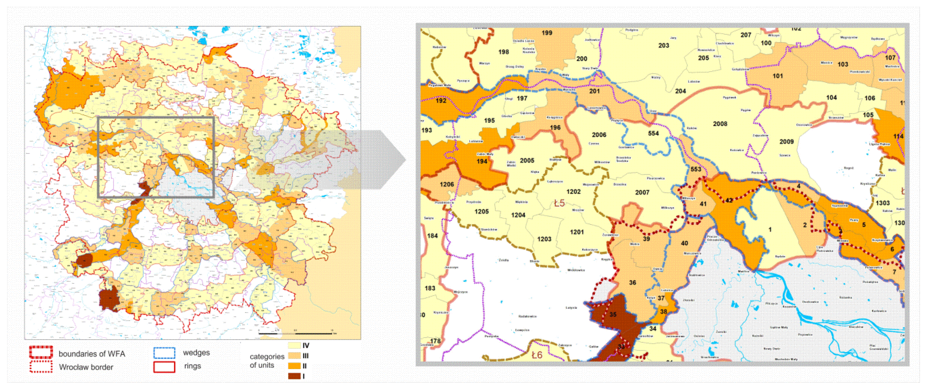
3.2.1. Division of the GI WFA System into Landscape-Functional Units (LaFU) (Step IIa)

The second stage of the research began with the division of the GI WFA system into landscape-functional units (LaFU). This allowed for further research and its evaluation on a local scale. The sizes of LaFU in WFA are very diverse and range from approx. 43 ha to approx. 8086 ha. Their spatial distribution is shown in Figure 5.
About ⅓ (30.1%) of the entire GI WFA system is open areas (LaFU type K), 16.2% is areas with a large share of greenery (LaFU type A), and areas related to water are approx. 13.6% (LaFU type F, G, H, and I) (Figure 6).
Within each ring, open areas (LaFU type K) occupy a similar area of just over 30%, only in the R2 ring is it slightly smaller and amounts to approx. 22%. The share of areas with water elements (LaFU type F, G, H, and I) in the ring R1 exceeds 40%, and in the ring R3b, it is only approx. 6%. In addition, the northern part of the ring 3 (R3a) differs from its southern part (R3b). The north is dominated by areas covered with forest complexes and groups of trees (over 70%); in the south, there is 80% of open areas and areas associated with surface waters (Figure 7).

3.2.2. LaFU Categorization. Analysis of the Units in Terms of their Importance for the Maintenance of Continuity (Step IIb)

In step IIb, individual LaFU units were analyzed in terms of their importance for the continuity of the planned system and communication of its most important elements: the units constituting the core of rings and wedges (units K1) and units K2 and U—supporting and supplementing ones—were determined.
The analysis of the LaFU categories in the entire GI WFA system has shown that about 50% of the whole is the LaFU category K1 that ensures the continuity of the GI system. In rings R1 and R2, the K1 units account for almost half of all the LaFU. In ring R3, in its northern part, nearly 64% of all the units are K1 units, which proves a strong structure of this element, while in the southern part of ring R3, K1 units are only ⅓ of all LaFU (Figure 8).
The units of category K1 are mainly units covered with high greenery and waters (types A, B, and G), whereas units K2 and U designed to complement and support the system are large open spaces (type K) (Figure 9).

3.2.3. LaFU Hierarchization (Step IIc)

In the analyzed GI system in WFA, two types of nodal units were adopted: the ones located at sites of intersecting rings and wedges (marked with the LaFU symbol (1)) and ones located at the intersection of connectors and rings (marked LaFU (2)) (Figure 10).
A significant part, approx. 43% of the nodal units in LaFU (1), are units in which there are areas covered with waters (F, G, and H) (Figure 11a); they are located at the intersections of the most important elements of the system, i.e., rings with wedges based on the tributaries of the Oder River (Widawa, Ślęza, and Bystrzyca).
After considering the second criterion regarding the ecological value, classes (C)—from C to C IV—were determined. Their distribution shows that the LaFUs of the highest class (located in the nodes and the most valuable natural areas) are in the south-western part of the GI WFA system (Figure 12).

3.2.4. LaFU Hierarchization (Step IId)

The next step examined the threats occurring in individual units of the proposed GI WFA system resulting from the current development (dispersion of buildings and fragmentation of natural areas), as well as from the provisions contained in the local planning documents (studies of conditions and directions of spatial development) regarding the planning expansion of areas designated for building development and other infrastructure investments (Figure 13).
It has been shown that nearly 70% of all LaFUs are units of type a—not threatened by urbanization—and over 30% of all LaFUs are units at risk of degradation because of the planned development of buildings—units of type b and c (Figure 14a). Nearly half of the units of category K2 and U (important for connectivity in the system GI WFA) are units at risk of the planned development of buildings (Figure 14b). These are at the same time units of type K, D, and E (Figure 14c).

3.2.5. Obligatory Actions within the WFA Area (Step IIe)

The summary of the conducted research was the identification of units requiring protective and strengthening measures or ones reducing threats in order to define the necessary actions. Such results and action recommendations form the basis for the provisions in the planning documents. In the case of WFA, they are the spatial development plan for the Lower Silesian Voivodeship (Province), the documents at the local level, the studies (studies of conditions and directions of spatial development), and the local plans.
For this purpose, values have been assigned to particular categories, classes and risks of LaFUs defined in the previously described stages. Then, the obligatory measures (O) were determined according to the following score:
  • Units with a total score 18, 15, 12 are I-degree obligatory measures
  • Units with a total score 9, 8, 7, 6 are II-degree obligatory measures
  • Units with a total score 5, 4, 3, 2 are III-degree obligatory measures
The analysis of the obligatory nature of taking protective measures and strengthening the GI WFA system has shown that the I-degree measures should be taken in the area of about 50% of the system, II-degree measures should be taking in the area of 38% of the system, and the III-degree measures should cover almost 8% of the system’s area (Figure 15a). The most of such actions should be undertaken in LaFU categories K1 and K2 constituting the core of the system. The II-degree obligatory actions apply to all LaFU categories equally (Figure 15b). Obligatory actions apply in particular to units of type D, E, G, and K (Figure 15c and Figure 16).
Next, a set of examples of activities within the particular types of units was prepared. These activities are aimed at strengthening the system and are addressed to all stakeholders (municipalities, planners and designers, NGOs, and citizens) (Table 3).

4. Discussion

4.1. Planning of the GI System

In GI planning, the occurrence of natural and semi-natural areas with high natural potential was taken into account, which is in line with the known, general recommendations [70,71]. The final layout of the GI WFA system also results from the need to adapt to the requirements of the planning regulations—the Concept of National Spatial Planning [59] and the need to introduce “green ring systems” in Polish city-regions. Therefore, the GI system, apart from its axis, wedges, and connectors (based mainly on hydrographic systems and combining high value natural areas), also consists of rings, with a large percentage of agricultural land. These open areas included in the GI system require sustainable management, among others: protection of mid-field tree clumps and greenery along smaller watercourses, planting trees along roads (including fruit trees), development of organic farming, recreation, and tourism, as well as inhibition of dispersed building development and fragmentation of land.
In this respect, certain analogies to the GI project in the Milan city-region area can be found in the GI WFA project [72], where the enormous urban expansion and decline of agricultural areas and other green semi-natural areas was an inspiration to take actions that were not only protective but also aimed at the restoration and rehabilitation of the GI. Before 1945, Lower Silesia was the base of food production and processing, not only for the region but also for the whole country (then, Germany). Also, today’s southern WFA, together with the preserved historic palace and park complexes, can become a tourist base and a place of healthy food production for the inhabitants of Wrocław and the region.
The need for changes in the management of agricultural areas in city-regions is observed not only in Europe [73,74] but also in dynamically changing peri-urban areas in China [75].
The issue of a multifunctionality of the GI system was considered at the level of creating the GI framework (stage I). Based on the current potential of individual sites, it includes both strengthening of the current functions of individual areas and the introduction of new ones.
There was no consideration of the temporal variability of functions in individual parts of the system or potential conflicts between functions, which is a challenge for multifunctional planning [76]. In the planned GI WFA system, conflicts could arise between ecological and social functions, especially with the intensive use of high-quality nature areas [77]. Issues related to the multifunctionality of the GI WFA system constitute an area for further work at the local level. This would allow for the application and verification of approaches used in multifunctional planning at the city level [9,10].

4.2. Evaluation of the System GI

The evaluation of the GI system proposed in the LaFU Method was dictated by the Polish tradition of landscape research and guidelines concerning the need to formulate provisions for 1) studies of conditions and directions of spatial development, which are a kind of development strategy but not an act of local law, and 2) spatial development plans, developed for the whole or part of an administrative unit (municipality), and which are acts of local law.
The division of the area covered by the GI system into LaFUs with possible because the most similar land cover type was considered universal and applicable in all other city-region areas.
The adoption of the administrative division in the designation of units used was considered less appropriate because in Poland, the size of the basic administrative unit—the municipality—would be too large for the GI assessment. In addition, the use of LaFUs allowed us to refer to the variability and specificity of the landscape in the studied area, which cannot be obtained by using administrative divisions or geometric divisions (e.g., dividing into a grid of squares), as proposed for example in the design of the “National Green Network” in Australia [78].

4.3. Next Steps—Implementation of the GI System

The GI system should be included in regional and local planning documents to be meaningful in a sustainable and resilient development of city-regions. Dissemination of the GI concept in scientific and political circles does not always guarantee its inclusion in spatial development policies [79,80,81].
Therefore, a good step on the part of the local authorities of Wrocław and the institutions responsible for the implementation of the strategic and planning documents for WFA is not only to initiate and finance the GI WFA project but also to enter the accomplished GI project into the WFA spatial development plan (2018), which is currently being developed. It is an important planning document due to the fact that its provisions are mandatory in individual municipalities. It is an opportunity for the systemic inclusion of GI in municipalities’ investment activities and decisions and its gradual implementation. The intention is also to introduce the concept of GI to the superior spatial development plan for the region of Lower Silesia—a document regulating the spatial development of the entire region. Currently, there are works underway to change it; the works will also include recommendations regarding the GI WFA system as well as the very concept of the GI.
However, not only records in planning documents but also management and financing decide on undertaking real spatial activities for GI. It would be beneficial and necessary to involve also NGOs and their participation in the implementation of works related to projects for protecting, restoring, and creating GI. It would be advisable, for example, to draw the attention of the Association of Wrocław Agglomeration Municipalities, which comprises the majority of WFA municipalities. As shown by the examples of other GI projects, the involvement of NGOs contributes to their success; this commitment is often also important in the initial stage, as an impulse for the creation of GI plans, as, for example, in the Montreal region [82], as well as during the implementation of the proposed solutions [83].
According to the original assumptions of the spatial policy of the state, a metropolitan union (an association of territorial self-government units) was to coordinate the planning and management of the functional area, which is practiced in various metropolitan areas around the world. It would give a certain kind of independence to WFA and the possibility of coherent management of the whole area. This form of management has worked well in Milan, where in 2015, the Province of Milan established an institution named Metropolitan City, which was responsible, among others, for shaping and protecting greenery in the metropolitan area [2]. Currently, however, there is no legal possibility at the level of the national spatial policy to establish a metropolitan union in the WFA.

4.4. Conclusion

The LaFU method tested in WFA, which is presented in the article, shows an approach to designing a coherent and multifunctional system of GI on a regional scale (“structural-multifunctional” approach). At the same time, it creates the possibility to determine the crucial areas for the proper functioning of the system as well as those that require certain strengthening activities. The LaFU method is appropriate for the areas surrounding large cities where it is necessary to preserve biologically active areas and connections between them and to plan the functions of these areas. This is important not only for the sustainable development of the region but also for the city itself, which uses the green infrastructure of the area around it.

Author Contributions

Conceptualization, I.N-F. and J.R.; data curation, I.N-F. and P.F.; formal analysis, I.N-F.; funding acquisition, I.NF.; investigation, I.N-F, J.R, J.P, and P.-F.; methodology, I.N-F and J.R; project administration, I.N-F; resources, P.F; software, P.F.; supervision, I.N-F and J.R; validation, I.N-F. and J.R; visualization, P.F.; writing—original draft, I.N-F and J.R; writing—review and editing, I.N-F and J.R.

Funding

This research was funded by the Institute for Territorial Development (IRT). It was one of the elements of the larger project known as “Study of the functional coherence in the Wrocław Functional Area” (2015) co-financed by the European Union under the Operational Programme of Technical Assistance 2007–2013, in which the Wrocław district was the leader.

Acknowledgments

The authors wish to thank the Institute for Territorial Development (IRT) especially Witold Warczewski who cooperated with the authors during this research.

Conflicts of Interest

The authors declare no conflict of interest.

References

  1. Wang, J.; Banzhaf, E. Towards a better understanding of Green Infrastructure: A critical review. Ecol. Indic. 2018, 85, 758–772. [Google Scholar] [CrossRef]
  2. Davies, C.; Hansen, R.; Rall, E.; Pauleit, S.; Lafortezza, R.; de Bellis, Y.; Santos, A.; Tosics, I. Green Infrastructure Planning and Implementation. GREEN SURGE Report 5.1. 2015. Available online: https://greensurge.eu (accessed on 15 July 2018).
  3. Benedict, M.A.; McMahon, E.T. Green Infrastructure: Smart Conservation for the 21st Century; The Conservation Fund and Sprawl Watch Clearinghouse: Arlington, VA, USA, 2002. [Google Scholar]
  4. Ignatieva, M.; Stewart, G.H.; Meurk, C. Planning and design of ecological networks in urban areas. Landsc. Ecol. Eng. 2011, 7, 17–25. [Google Scholar] [CrossRef]
  5. Pauleit, S.; Liu, L.; Ahern, J.; Kazmierczak, A. Multifunctional green infrastructure planning to promote ecological services in the city. In Urban Ecology. Patterns, Processes and Applications, 2nd ed.; Niemelä, J., Breuste, J.H., Guntenspergen, G., McIntyre, N.E., Elmqvist, T., James, P., Eds.; Oxford University Press: Oxford, UK, 2011; pp. 272–285. ISBN 978-0-19-956356-2. [Google Scholar]
  6. Madureira, H.; Andersen, T. Planning for multifunctional urban green infrastructures: Promises and challenges. Urban Des. Int. 2014, 19, 38–49. [Google Scholar] [CrossRef]
  7. Niemelä, J.; Saarela, S.R.; Söderman, T.; Kopperoinen, L.; Yli-Pelkonen, V.; Väre, S.; Kotze, D.J. Using the ecosystem services approach for better planning and conservation of urban green spaces: A Finland case study. Biodivers. Conserv. 2010, 19, 3225–3243. [Google Scholar] [CrossRef]
  8. Lovell, S.T.; Taylor, J.R. Supplying urban ecosystem services through multifunctional green infrastructure in the United States. Landsc. Ecol. 2013, 28, 1447–1463. [Google Scholar] [CrossRef]
  9. Hansen, R.; Pauleit, S. From multifunctionality to multiple ecosystem services? A conceptual framework for multifunctionality in green infrastructure planning for urban areas. Ambio 2014, 43, 516–526. [Google Scholar] [CrossRef]
  10. Hansen, R.; Rolf, W.; Rall, E.; Pauleit, S.; Erlwein, S.; Fohlmeister, S.; Santos, A.; Luz, A.C.; Branquinho, C.; Santos-Reis, M.; et al. Advanced Approaches and Strategies for UGI Planning and Implementation. GREEN SURGE Technical Report D 5.2. 2016. Available online: https://greensurge.eu (accessed on 10 October 2018).
  11. Kaplan, A. “Green Infrastructure” Concept as an Effective Medium to Manipulating Sustainable Urban Development. In Green and Ecological Technologies for Urban Planning: Creating Smart Cities (Volume in “Regional Development: Concepts, Methodologies, Tools and Applications”); Ercoskun, O.Y., Ed.; IGI Global: Hershey, PA, USA, 2011; pp. 234–255. [Google Scholar] [CrossRef]
  12. Breuste, J.; Artmann, M.; Li, J.X.; Xie, M.M. Special issue on green infrastructure for urban sustainability. J. Urban Plan. Dev. 2015, 141, A2015001-1–A2015001-5. [Google Scholar] [CrossRef]
  13. Wei, J.; Qian, J.; Tao, Y.; Hu, F.; Ou, W. Evaluating Spatial Priority of Urban Green Infrastructure for Urban Sustainability in Areas of Rapid Urbanization: A Case Study of Pukou in China. Sustainability 2018, 10, 327. [Google Scholar] [CrossRef]
  14. Gill, S.E.; Handley, J.F.; Ennos, A.R.; Pauliet, S. Adapting Cities for Climate Change: The Role of Green Infrastructure. Built Environ. 2007, 33, 115–133. [Google Scholar] [CrossRef]
  15. Raven, J. Cooling the Public Realm: Climate-Resilient Urban Design. In Resilient Cities: Cities and Adaptation to Climate Change; Zimmermann, K., Ed.; Springer: Heidelberg, Germany, 2011; pp. 451–463. [Google Scholar]
  16. Lin, B.B.; Meyers, J.; Beaty, R.M.; Barnett, G.B. Urban green infrastructure impacts on climate regulation services in Sydney, Australia. Sustainability 2016, 8, 788. [Google Scholar] [CrossRef]
  17. Kim, S.Y.; Kim, B.H.S. The effect of urban green infrastructure on disaster mitigation in Korea. Sustainability 2017, 9, 1026. [Google Scholar] [CrossRef]
  18. Bai, T.; Mayer, A.L.; Shuster, W.D.; Tian, G. The Hydrologic Role of Urban Green Space in Mitigating Flooding (Luohe, China). Sustainability 2018, 10, 3584. [Google Scholar] [CrossRef]
  19. Hostetler, M.; Allen, W.; Meurk, C. Conserving urban biodiversity? Creating green infrastructure is only the first step. Landsc. Urban Plan. 2011, 100, 369–371. [Google Scholar] [CrossRef]
  20. Garmendia, E.; Apostolopoulou, E.; Adams, W.M.; Bormpoudakis, D. Biodiversity and Green Infrastructure in Europe: Boundary object or ecological trap? Land Use Policy 2016, 56, 315–319. [Google Scholar] [CrossRef]
  21. Salomaa, A.; Paloniemi, R.; Kotiaho, J.S.; Kettunen, M.; Apostolopoulou, E.; Cent, J. Can green infrastructure help to conserve biodiversity? Environ. Plan. C Politics Spaces 2017, 35, 265–288. [Google Scholar] [CrossRef]
  22. Liu, L.; Bergen, J.M. Green infrastructure for sustainable urban water management: Practices of five forerunner cities. Cities 2018, 74, 126–133. [Google Scholar] [CrossRef]
  23. Kazak, J.K.; Chruściński, J.; Szewrański, S. The Development of a Novel Decision Support System for the Location of Green Infrastructure for Stormwater Management. Sustainability 2018, 10, 4388. [Google Scholar] [CrossRef]
  24. Tzoulas, K.; Korpela, K.; Venn, S.; Yli-Pelkonen, V.; Kaźmierczak, A.; Niemela, J.; James, P. Promoting ecosystem and human health in urban areas using Green Infrastructure: A literature review. Landsc. Urban Plan. 2007, 81, 167–178. [Google Scholar] [CrossRef] [Green Version]
  25. Coutts, C.; Hahn, M. Green Infrastructure, Ecosystem Services, and Human Health. Int. J. Environ. Res. Public Health 2015, 12, 9768–9798. [Google Scholar] [CrossRef] [Green Version]
  26. O’Brien, L.; De Vreese, R.; Kern, M.; Sievänen, T.; Stojanova, B.; Atmiş, E. Cultural ecosystem benefits of urban and peri-urban green infrastructure across different European countries. Urban For. Urban Green. 2017, 24, 236–248. [Google Scholar] [CrossRef]
  27. Bowen, K.J.; Lynch, Y. The public health benefits of green infrastructure: The potential of economic framing for enhanced decision-making. Curr. Opin. Environ. Sustain. 2017, 25, 90–95. [Google Scholar] [CrossRef]
  28. Nature and Countryside within the Urban Fringe, European Periurban Areas: Characterization and a Management Recommendation. Junta de Andalucía. Consejería de Agricultura, Pesca y Medio Ambiente, collaboration European Federation of Metropolitan and Periurban Natural and Rural Spaces (Fedenatur). 2012. Available online: https://www.europarc.org/wp-content/uploads/2017/10/R_2012_Nature-and-Countryside-within-the-Urban-Fringe.-European-Periurban-areas-characterisation-manag.pdf (accessed on 11 December 2018).
  29. Meeus, S.J.; Gulinck, G. Semi-Urban Areas in Landscape Research: A Review. Living Rev. Landsc. Res. 2008, 2, 1–45. [Google Scholar] [CrossRef]
  30. Thorbeck, D. Architecture and Agriculture: A Rural Design Guide, 1st ed.; Routledge: London, UK, 2016; ISBN 9781317384359. [Google Scholar]
  31. European Environmental Agency. Urban Sprawl in Europe. The Ignored Challenge; Technical Report No. 10/2006; Office for Official Publications of the European Communities: Luxembourg, 2006; ISBN 92-9167-887-2. Available online: https://www.eea.europa.eu/publications/eea_report_2006_10/eea_report_10_2006.pdf/view (accessed on 11 December 2018).
  32. Robinson, D.T. Land-cover fragmentation and configuration of ownership parcels in an exurban landscape. Urban Ecosyst. 2012, 15, 53–69. [Google Scholar] [CrossRef]
  33. Shrestha, M.K.; York, A.M.; Boone, C.G.; Zhang, S. Land fragmentation due to rapid urbanization in the Phoenix Metropolitan Area: Analyzing the spatiotemporal patterns and drivers. Appl. Geogr. 2012, 32, 522–531. [Google Scholar] [CrossRef]
  34. Liu, J.; Daily, G.C.; Ehrlich, P.R.; Luck, G.W. Effects of household dynamics on resource consumption and biodiversity. Nature 2003, 421, 530–533. [Google Scholar] [CrossRef]
  35. McKinney, M.L. Urbanization, Biodiversity and Conservation. BioScience 2002, 52, 883–890. [Google Scholar] [CrossRef]
  36. Carter-Whitney, M.; Esakin, T.C. Ontario’s Greenbelt in an International Context; Friends of the Greenbelt Foundation: Toronto, ON, Canada, 2010; Available online: http://www.greenbelt.ca/ontario_s_greenbelt_in_an_international_context2010 (accessed on 10 December 2018).
  37. Lemes de Oliveira, F. Green Wedge Urbanism: History, Theory and Contemporary Practice; Bloomsbury Academic: New York, NY, USA, 2017; ISBN 9781474229180. [Google Scholar]
  38. Ahern, J. Greenways as a planning strategy. Landsc. Urban Plan. 1995, 33, 131–155. [Google Scholar] [CrossRef]
  39. Bryant, M.M. Urban landscape conservation and the role of ecological greenways at local and metropolitan scales. Landsc. Urban Plan. 2006, 76, 23–44. [Google Scholar] [CrossRef]
  40. Fabos, J.G. Greenway planning in the United States: Its origins and recent case studies. Landsc. Urban Plan. 2004, 68, 321–342. [Google Scholar] [CrossRef]
  41. Walmsley, A. Greenways: Multiplying and diversifying in the 21st century. Landsc. Urban Plan. 2006, 76, 252–290. [Google Scholar] [CrossRef]
  42. Niedźwiecka-Filipiak, I.; Rubaszek, J.; Pyszczek, J. Forming the system of greenery in the city and suburban zone. The selected issues on the example of Minneapolis and Wrocław. In Topiarius, Landscapes Studies. Polish Landscape. The Grass Is Always Greener on the Other Side of the Fence. Protection and Shaping of the Native Landscape; University of Rzeszów: Rzeszów, Poland, 2016; Volume 2, pp. 117–130. Available online: http://www.topiarius.ur.edu.pl/wp-content/uploads/MONO_T2_Niedzwiecka_Rubaszek_Pyszczek.pdf (accessed on 12 December 2018). (In Polish)
  43. Thomas, K.; Littlewood, S. From green belts to green infrastructure? The evolution of a new concept in the emerging soft governance strategies. Plan. Pract. Res. 2010, 25, 203–222. [Google Scholar] [CrossRef]
  44. Amati, M.; Taylor, L. From green belt to green infrastructure. Plan. Pract. Res. 2010, 25, 143–155. [Google Scholar] [CrossRef]
  45. Weber, T.; Sloan, A.; Wolf, J. Maryland’s green infrastructure assessment: Development of a comprehensive approach to land conservation. Landsc. Urban Plan. 2006, 77, 94–110. [Google Scholar] [CrossRef]
  46. Vogt, P.; Riitters, K.H.; Estreguil, C.; Kozak, J.; Wade, T.G.; Wickham, J.D. Mapping spatial patterns with morphological image processing. Landsc. Ecol. 2007, 22, 171–177. [Google Scholar] [CrossRef]
  47. Pei, D. Review of Green Infrastructure Planning Methods. City Plan. Rev. 2012, 36, 84–90. [Google Scholar]
  48. Zhang, Y.; Li, L.; Wu, G.S.; Zhou, Y.; Qin, S.P.; Wang, X.M. Analysis of landscape connectivity of the Yunnan snub-nosed monkeys (Rhinopithecus bieti) based on habitat patches. Acta Ecol. Sin. 2016, 36, 51–58. [Google Scholar]
  49. Hong, S.H.; Han, B.H.; Choi, S.H.; Sung, C.Y.; Lee, K.J. Planning an ecological network using the predicted movement paths of urban birds. Landsc. Ecol. Eng. 2013, 9, 165–174. [Google Scholar] [CrossRef]
  50. Zetterberg, A.; Mortberg, U.M.; Balfors, B. Making graph theory operational for landscape ecological assessments, planning, and design. Landsc. Urban Plan. 2010, 95, 181–191. [Google Scholar] [CrossRef]
  51. Kong, F.; Yin, H.; Nakagoshi, N.; Zong, Y. Urban green space network development for biodiversity conservation: Identification based on graph theory and gravity modeling. Landsc. Urban Plan. 2010, 95, 16–27. [Google Scholar] [CrossRef]
  52. Shi, X.; Qin, M. Research on the Optimization of Regional Green Infrastructure Network. Sustainability 2018, 10, 4649. [Google Scholar] [CrossRef]
  53. Meerow, S.; Nevel, J.P. Spatial planning for multifunctional green infrastructure: Growing resilience in Detroit. Landsc. Urban Plan. 2017, 159, 62–75. [Google Scholar] [CrossRef]
  54. Lafortezza, R.; Davies, C.; Sanesi, G.; Konijnendijk, C.C. Green Infrastructure as a tool to support spatial planning in European urban regions. iForest 2013, 6, 102–108. [Google Scholar] [CrossRef] [Green Version]
  55. European Commission. Commission Staff Working Document, The EU Environmental Implementation Review Country Report–POLAND. 2017. Available online: http://eur-lex.europa.eu/legal-content/PL/TXT/?uri=CELEX:52017SC0053 (accessed on 22 November 2018).
  56. Szulczewska, B.; Giedych, R.; Maksymiuk, G. Can we face the challenge: How to implement a theoretical concept of green infrastructure into planning practice? Warsaw case study. Landsc. Res. 2017, 42, 176–194. [Google Scholar] [CrossRef]
  57. Hubacek, K.; Kronenberg, J. Synthesizing different perspectives on the value of urban ecosystem services. Landsc. Urban Plan. 2013, 109, 1–6. [Google Scholar] [CrossRef]
  58. Giedych, R.; Maksymiuk, G. Specific features of parks and their impact on regulation and cultural ecosystem services provision in Warsaw, Poland. Sustainability 2017, 9, 792. [Google Scholar] [CrossRef]
  59. Concept of National Spatial Planning 2030. Available online: http://prawo.sejm.gov.pl/isap.nsf/download.xsp/WMP20120000252/O/M20120252-1.pdf (accessed on 22 November 2018). (In Polish)
  60. Niedźwiecka-Filipiak, I.; Potyrała, J.; Filipiak, P. Contemporary management of green infrastructure within the borders of Wrocław Functional Area (WFA). Landsc. Archit. 2015, 47, 4–27. [Google Scholar]
  61. Bogdanowski, J. The Method of Landscape-Architecture Interior Units (JARK-WAK) in Study and Design, 4th ed.; Cracow University of Technology: Cracow, Poland, 1999; ISBN 83-7242-077-7. (In Polish) [Google Scholar]
  62. Study of the Functional Coherence in the Wrocław Functional Area. 2015. Available online: http://www.powiatwroclawski.pl/web/uploads/pub/news/news_2458/epub.pdf (accessed on 11 December 2018). (In Polish).
  63. Local Data Bank. 2018. Available online: https://bdl.stat.gov.pl/BDL (accessed on 11 December 2018). (In Polish)
  64. Szewrański, S.; Kazak, J.; Sasik, J. Suburbanization processes and their environmental effects in a zone of uncontrolled spread of a large city. Res. Pap. Wroc. Univ. Econ. 2013, 293, 170–179. (In Polish) [Google Scholar]
  65. Tokarczyk-Dorociak, K.; Kazak, J.; Szewrański, S. The Impact of a Large City on Land Use in Suburban Area—The Case of Wrocław (Poland). J. Ecol. Eng. 2018, 19, 89–98. [Google Scholar] [CrossRef]
  66. Strategy of Integrated Territorial Investments of the Wrocław Functional Area. 2015. Available online: https://zitwrof.pl/wp-content/uploads/2016/04/Strategia-Zintegrowanych-Inwestycji-Terytorialnych-Wroclawskiego-Obszaru-Funkcjonalnego-wraz-z-pozytywnymi-opiniami.pdf (accessed on 11 December 2018). (In Polish).
  67. EEA. Climate Change, Impacts and Vulnerability in Europe; Report No 1/2017; Publications Office of the European Union: Luxembourg, 2017; ISBN 978-92-9213-835-6. [Google Scholar]
  68. Kazak, J. The use of a decision support system for sustainable urbanization and thermal comfort in adaptation to climate change actions–the case of the Wrocław larger urban zone (Poland). Sustainability 2018, 4, 1083. [Google Scholar] [CrossRef]
  69. Szewrański, S.; Kazak, J.; Żmuda, R.; Wawer, R. Indicator-Based Assessment for Soil Resource Management in the Wrocław Larger Urban Zone of Poland. Pol. J. Environ. Stud. 2017, 26, 2239–2248. [Google Scholar] [CrossRef] [Green Version]
  70. European Environmental Agency. Green Infrastructure and Territorial Cohesion. The Concept of Green Infrastructure and Its Integration into Policies Using Monitoring Systems; Technical Report No. 18/2011; Publications Office of the European Union: Luxembourg, 2011; ISBN 978-92-9213-242-2. Available online: https://www.eea.europa.eu/publications/green-infrastructure-and-territorial-cohesion (accessed on 12 November 2018).
  71. Sundseth, K.; Sylwester, A. Towards Green Infrastructure for Europe: Proceedings of the European Commission workshop 25–26 March 2009; European Commission: Brussels, Belgium, 2009; Available online: http://catalogue.biodiversity.europa.eu/uploads/document/file/1238/Green_Infrastructure_workshop_2009.pdf (accessed on 20 November 2018).
  72. Sanesi, G.; Colangelo, G.; Lafortezza, R.; Davies, E. Urban green infrastructure and urban forests: A case study of the Metropolitan Area of Milan. Landsc. Res. 2017, 42, 164–175. [Google Scholar] [CrossRef]
  73. Senes, G.; Toccalini, A.; Ferrario, P.S.; Lafortezza, R.; Dal Sasso, P. Controlling Urban Expansion in Italy with Green Belts. In Urban Green Belts in the Twenty first Century; Amati, M., Ed.; Ashgate Publishing Limited: Aldershot, UK, 2008; pp. 204–225. ISBN 978-0-7546-4959-5. [Google Scholar]
  74. Werner, R.; Peters, D.; Lenz, R.; Pauleit, S. Farmland—An Elephant in the Room of Urban Green Infrastructure? Lessons learned from connectivity analysis in three German cities. Ecol. Indic. 2017, 94, 151–163. [Google Scholar] [CrossRef]
  75. Robinson, G.M.; Song, B. Transforming the Peri-Urban Fringe in China: The Example of Xi’an-Xianyang. Sustainability 2018, 10, 3932. [Google Scholar] [CrossRef]
  76. Roe, M.; Mell, I.C. Negotiating value and priorities: Evaluating the demands of green infrastructure development. J. Environ. Plan. Manag. 2013, 56, 650–673. [Google Scholar] [CrossRef]
  77. Sikorska, D.; Sikorski, P.; Hopkins, R.J. High Biodiversity of Green Infrastructure Does Not Contribute to Recreational Ecosystem Services. Sustainability 2017, 9, 334. [Google Scholar] [CrossRef]
  78. Kilbane, S. Green infrastructure: Planning a national green network for Australia. J. Landsc. Archit. 2013, 8, 64–73. [Google Scholar] [CrossRef]
  79. Albert, C.; von Haaren, C. Implications of applying the green infrastructure concept in landscape planning for ecosystem services in peri-urban areas: An expert survey and case study. Plan. Pract. Res. 2017, 32, 227–242. [Google Scholar] [CrossRef]
  80. Davies, C.; Lafortezza, R. Urban green infrastructure in Europe: Is greenspace planning and policy compliant? Land Use Policy 2017, 69, 93–101. [Google Scholar] [CrossRef]
  81. Grădinaru, S.R.; Hersperger, A.M. Green infrastructure in strategic spatial plans: Evidence from European urban regions. Urban For. Urban Green. 2018. [Google Scholar] [CrossRef]
  82. Dupras, J.; Drouin, C.; André, P.; Gonzalez, A. Towards the Establishment of a Green Infrastructure in the Region of Montreal (Quebec, Canada). Plan. Pract. Res. 2015, 30, 355–375. [Google Scholar] [CrossRef]
  83. Hansen, R.; Buizer, M.; Rall, E.; DeBellis, Y.; Davies, C.; Elands, B.; Wiersum, F.; Pauleit, S. Report of Case Study City Portraits. APPENDIX–GREEN SURGE Study on Urban Green Infrastructure Planning and Governance in 20 European Case Studies. Available online: https://greensurge.eu (accessed on 12 December 2018).
Figure 1. LaFU categorization determining units K1, K2, and U: (a) Examples of the LaFU types and their arrangement in a fragment of the GI system; (b) determining units category K1; (c) analysis of the connections between LaFU category K1; (d) determining LaFU category K2; (e) determining LaFU category U; and (f) clarification of the boundaries of the selected element of the GI system.
Sustainability 11 00394 g001
Figure 2. Location of the Wrocław Functional Area (WFA) (a) in Poland and (b) in Lower Silesia and (c) the WFA administrative division.
Sustainability 11 00394 g002
Figure 3. Diagrams showing the performed analyses and the synthesis of the results as well as the design of the GI WFA system design: (a) The initial map with the inventory of natural and semi-natural elements; Analyses (step Ia); (b) river valleys with their impact range; (c) the protected green areas; (d) the green areas not covered by legal protection; Synthesis (step Ib); (e) the Odra river valley (main axis); (f) the open areas with greenery (rings); (g) the valleys of the rivers: Bystrzyca, Strzegomka, Ślęza, and Dobra (wedges); and (h) the GI WFA system.
Sustainability 11 00394 g003
Figure 4. Final diagram of the system GI WFA—main axis O1 and O2; rings R1, R2, and R3; wedges D1–D6; and connectors L1–L6. (a) Conceptual diagram and (b) main functions.
Sustainability 11 00394 g004
Figure 5. Planned GI WFA system with divisions into landscape-functional unit types (LaFU).
Sustainability 11 00394 g005
Figure 6. Percentage of the surface area of individual LaFU types in the entire GI WFA system.
Sustainability 11 00394 g006
Figure 7. Percentage of the surface area of individual LaFU types in (a) Ring R1; (b) Ring R2; (c) Ring R3a; and (d) Ring R3b.
Sustainability 11 00394 g007
Figure 8. Distribution of units K1, K2, and U (a) in the entire GI WFA system; (b) in the R1 ring, (c) in the R2 ring, (d) in the R3a ring, and (e) in the R3b ring.
Sustainability 11 00394 g008
Figure 9. Relation between units of category K1, K2, and U and units of type A–L.
Sustainability 11 00394 g009
Figure 10. The scheme of determining nodal LaFU (1) and (2) in the GI WFA system: (a) Diagram of the GI WFA system and selected area; (b) LaFU node units (1) (red color) in the selected part of the GFA WFA system, junction of main elements (rings and wedges); and (c) LaFU node units (2) (red color) in the selected part of the GI WFA system, junction of connectors and rings.
Sustainability 11 00394 g010
Figure 11. (a) Relation between LaFU nodal units (1) with units of a given type related to the type of land cover (LaFU A-L) and (b) Relation between LaFU units (1) and K1, K2, and U units. Most LaFU (1) are also K1 units. In about 73% they are also units of category K1 constituting the backbone of the whole system.
Sustainability 11 00394 g011
Figure 12. LaFU in the GFA WFA system by class division—C I, C II, C III, and C IV depending on the location in the nodes and on the ecological values.
Sustainability 11 00394 g012
Figure 13. Map showing conflict areas and areas threatened with degradation due to the planned building development. Data based on the planning documents: studies of conditions and directions of spatial development—not yet legally binding.
Sustainability 11 00394 g013
Figure 14. (a) Percentage of units a, b, and c in the entire GI WFA system; (b) the distribution of units b and c in the entire GI WFA system with respect to units of categories K1, K2 and U; and (c) the relation between units a, b, and c and type A–L units in the entire GI WFA system.
Sustainability 11 00394 g014
Figure 15. (a) The obligatory nature of the protective measures in the entire system—grade I, II, and III; (b) the obligatory actions in relation to the LaFU categories K1, K2, and U; and (c) the obligatory actions I, II, and III degree in relation to LaFU type A–L.
Sustainability 11 00394 g015
Figure 16. The map showing the division of LaFU in terms of the obligatory protective measures within them, strengthening or reducing the threats to the functioning of the proposed GI WFA system.
Sustainability 11 00394 g016
Table 1. Types of landscape-functional units (LaFU).
Type of Unit—SymbolType of Unit—Description
Aforests and groups of greenery with a compact area over 25 ha
Bforests and groups of greenery with a compact area over 25 ha with surface waters
Cforests and groups of greenery with a compact area over 25 ha with internal open spaces
Dforests and groups of greenery with an area of about 5–25 ha
Egreenery complexes—with an area of about 0.5–5 ha
Fwatercourses in open areas (farmlands)
Gwatercourses with greenery
Hsurface standing waters with treeless surroundings (in open areas)
Isurface standing waters together with groups of greenery
Jorchard complexes
Kdomination of open areas (farmlands)
Lurbanized areas—cities
/Zvarious types of LaFU with housing complexes and/or economic activity zones
Table 2. Proposed functions of the planned system GI WFA (based on workshops with stakeholders in the years 2016–2017).
FunctionsAction AreasConstituent Elements of the Planned GI WFA System
Ring R1 Ring R2Ring R3Wedges D1-D5
Connectors L1-L4
Axis
O1, O2
Protection, regulationlocal climate regulationxxxxx
biodiversity protectionxxxxx
water protectionxx
flood protectionxx
prevention of soil erosionxxxxx
protection of natural green heritagexxxxx
Tourism and recreationdaily tourismxx
single-day tourismxxx
weekend tourismxx
agritourism in network of thematic villagesx
“edible villages, towns”xx
lanes of fruit trees along trails and routesxxx
tourist bases and centres (gastronomy, accommodation, tourist information, and parking facilities)xx
tourist trails (walking, cycling, and horse-riding) and thematic trails, e.g., environmental, cultural, palace-park, and palace and manor house onesxxxxx
cycling pathsxxxxx
water tourism
(marinas and kayaking)
xx
sport and recreation areasx
parksx
Food productionhealthy food productionxxx
vineyards—wine productionxx
orchards, fruit productionxx
Table 3. List of actions that need to be taken in different types of LaFU.
Types of AreaAction Examples (Open Set)Types of LaFU
ABCDEFGHIJKL/Z
1Non-urbanized areasIntroduction of green buffer strip between fieldsxxxx
2Recreating historic alleys and rows, tree plantings along roads (e.g., fruit trees)xxxxx
3Planting new alleys and rows of vegetationxxxxxxx
4Recreation of vegetation accompanying water reservoirsxxxxx
5Renaturalisation of water courses and reservoirsxxx
6Protection of wetlandsxxxx
7Healthy food production—eco-farmingxxxxxx
8Creating of eco-orchardsxxx
9Forestation of areas of low valuation class soilsx
10Restoration of proper natural habitat conditionsxxxxxxxxxxxxx
11Areas of the village and other areas with buildingsPlanting trees in private property areasxxxxxxxxxxxxx
12Planting trees in public spaces (also fruit trees)xxxxxxxxxxxxx
13Introducing of native speciesxxxxxxxxxxxxx
14Creation of orchards and eco-orchardsxxxxxxxxxxxxx
15Creation of parksxxxxxxxxxxxxx
16Creation of green squares and communal gardensxxxxxxxxxxxxx
17Introducing greenery of multilayered structurexxxxxxxxxxxxx
18Isolating vegetation near industrial and service facilitiesxxxxxxxxxxxxx
19Creation of floral meadowsxxxxxxxxxxxxx
20Creation of vegetable gardensxxxxxxxxxxxxx
21Creation of green roofs, green wallsxxxxxxxxxxxxx
22Application of pro-ecological solutions for rainwater managementxxxxxxxxxxxxx
23Non-dispersion of buildings and location of new buildings within designated built-up areasxxxxxxxxxxxxx

