Valuing Environmental Amenities in Peri-Urban Areas: Evidence from Poland


Abstract
1. Introduction
2. Materials and Methods
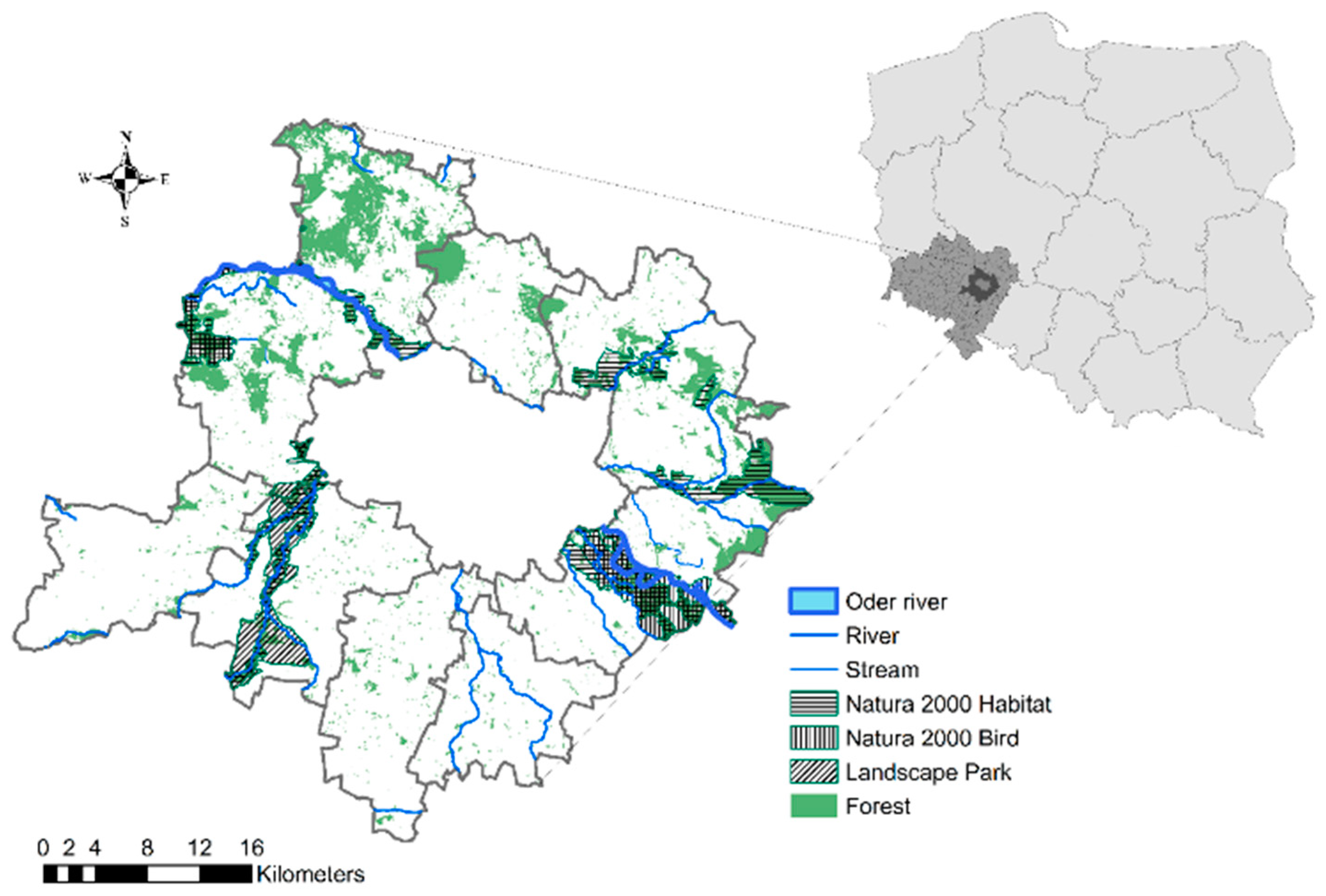
2.1. Peri-Urban Study Area
2.2. Data
2.3. The Variables
2.4. Methods
3. Results
4. Discussion
5. Conclusions
Author Contributions
Funding
Acknowledgments
Conflicts of Interest
References
- Camps-Calvet, M.; Langemeyer, J.; Calvet-mir, L.; Gómez-Baggethun, E. Ecosystem services provided by urban gardens in Barcelona, Spain: Insights for policy and planning. Environ. Sci. Policy 2016, 62, 14–23. [Google Scholar] [CrossRef]
- McPhearson, T.; Andersson, E.; Elmqvist, T.; Frantzeskaki, N. Resilience of and through urban ecosystem services. Ecosyst. Serv. 2014, 12, 152–156. [Google Scholar] [CrossRef]
- Andersson, E.; Barthel, S.; Borgstro, S.; Colding, J.; Elmqvist, T.; Folke, C.; Gren, A. Reconnecting Cities to the Biosphere: Stewardship of Green Infrastructure and Urban Ecosystem Services. Ambio 2014, 43, 445–453. [Google Scholar] [CrossRef]
- Haines-Young, R.; Potschin, M. The links between biodiversity, ecosystem services human well-being. In Ecosystem Ecology: A New Synthesis; Raffaelli, D.G., Frid, C.L.J., Eds.; Cambridge University Press: Cambridge, UK, 2010; pp. 110–139. [Google Scholar]
- Hennig, E.I.; Schwick, C.; Orlitová, E.; Kienast, F.; Jaeger, J.A.G. Multi-scale analysis of urban sprawl in Europe: Towards a European de-sprawling strategy. Land Use Policy 2015, 49, 483–498. [Google Scholar] [CrossRef]
- Long, H.; Liu, Y.; Hou, X.; Li, T.; Li, Y. Effects of land use transitions due to rapid urbanization on ecosystem services: Implications for urban planning in the new developing area of China. Habitat Int. 2014, 44, 536–544. [Google Scholar] [CrossRef]
- Walz, U.; Łowicki, D. Gradient of Land Cover and Ecosystem Service Supply Capacities—A Comparison of Suburban and Rural Fringes of Towns Dresden (Germany) and Poznan (Poland). Procedia Earth Planet. Sci. 2015, 15, 495–501. [Google Scholar] [CrossRef]
- The Economics of Ecosystems and Biodiversity (TEEB) Ecological and Economic Foundations; Pushpam Kumar, Ed.; Earthscan: London, UK; Washington, DC, USA, 2010. [Google Scholar]
- Cho, S.; Poudyal, N.C.; Roberts, R.K. Spatial analysis of the amenity value of green open space. Ecol. Econ. 2008, 66, 403–416. [Google Scholar] [CrossRef]
- Anderson, S.T.; West, S.E. Open space, residential property values, and spatial context. Reg. Sci. Urban Econ. 2006, 36, 773–789. [Google Scholar] [CrossRef]
- Morancho, A.B. A hedonic valuation of urban green areas. Landsc. Urban Plan. 2003, 66, 35–41. [Google Scholar] [CrossRef]
- Waltert, F.; Schläpfer, F. Landscape amenities and local development: A review of migration, regional economic and hedonic pricing studies. Ecol. Econ. 2010, 70, 141–152. [Google Scholar] [CrossRef]
- Tyrvainen, L. The amenity value of the urban forest: An application of the hedonic pricing method. Landsc. Urban Plan. 1997, 37, 211–222. [Google Scholar] [CrossRef]
- Fotheringham, A.S.; Crespo, R. Exploring, modelling and predicting spatiotemporal variations in house prices. Ann. Reg. Sci. 2015, 417–436. [Google Scholar] [CrossRef]
- Schläpfer, F.; Waltert, F.; Segura, L.; Kienast, F. Valuation of landscape amenities: A hedonic pricing analysis of housing rents in urban, suburban and periurban Switzerland. Landsc. Urban Plan. 2015, 141, 24–40. [Google Scholar] [CrossRef]
- Łowicki, D.; Piotrowska, S. Monetary valuation of road noise. Residential property prices as an indicator of the acoustic climate quality. Ecol. Indic. 2015, 52, 472–479. [Google Scholar] [CrossRef]
- Sander, H.A.; Polasky, S. The value of views and open space: Estimates from a hedonic pricing model for Ramsey County, Minnesota, USA. Land Use Policy 2009, 26, 837–845. [Google Scholar] [CrossRef]
- Melichar, J.; Kaprová, K. Revealing preferences of Prague’ s homebuyers toward greenery amenities: The empirical evidence of distance—Size effect. Landsc. Urban Plan. 2013, 109, 56–66. [Google Scholar] [CrossRef]
- Liebelt, V.; Bartke, S.; Schwarz, N. Revealing Preferences for Urban Green Spaces: A Scale-sensitive Hedonic Pricing Analysis for the City of Leipzig. Ecol. Econ. 2018, 146, 536–548. [Google Scholar] [CrossRef]
- Waltert, F.; Schulz, T.; Schläpfer, F. The role of landscape amenities in regional development: Evidence from Swiss municipality data. Land Use Policy 2011, 28, 748–761. [Google Scholar] [CrossRef]
- Gibbons, S.; Mourato, S.; Resende, G.M. The Amenity Value of English Nature: A Hedonic Price Approach. Environ. Resour. Econ. 2014, 57, 175–196. [Google Scholar] [CrossRef]
- Bulteau, J.; Feuillet, T.; Le Boennec, R. Spatial Heterogeneity of Sustainable Transportation Offer Values: A Comparative Analysis of Nantes Urban and Periurban/Rural Areas (France). Urban Sci. 2018, 2, 14. [Google Scholar] [CrossRef]
- Helbich, M. Do suburban areas impact house prices? Environ. Plan. B Plan. Des. 2015, 42, 431–449. [Google Scholar] [CrossRef]
- Nilsson, P. Natural amenities in urban space—A geographically weighted regression approach. Landsc. Urban Plan. 2014, 121, 45–54. [Google Scholar] [CrossRef]
- Zhang, X.; He, J.; Deng, Z.; Ma, J.; Chen, G.; Zhang, M.; Li, D. Comparative changes of influence factors of rural residential area based on spatial econometric regression model: A case study of Lishan Township, Hubei Province, China. Sustainability 2018, 10, 3403. [Google Scholar] [CrossRef]
- Ravetz, J.; Fertner, C.; Nielsen, T.S. The Dynamics of Peri-Urbanization. In Peri-Urban Futures: Scenarios and Models for Land use Change in Europe; Springer: Berlin/Heidelberg, Germany, 2013; pp. 1–453. ISBN 9783642305290. [Google Scholar]
- Lin, Y.; Ma, Z.; Zhao, K.; Hu, W.; Wei, J. The impact of population migration on urban housing prices: Evidence from China’s major cities. Sustainability 2018, 10, 3169. [Google Scholar] [CrossRef]
- Tokarczyk-Dorociak, K.; Kazak, J.; Szewrański, S. The Impact of a Large City on Land Use in Suburban Area – The Case of Wrocław (Poland). J. Ecol. Eng. 2018, 19, 89–98. [Google Scholar] [CrossRef]
- Szewrański, S.; Kazak, J.; Żmuda, R.; Wawer, R. Indicator-based assessment for soil resource management in the Wrocław Larger Urban Zone of Poland. Polish J. Environ. Stud. 2017, 26, 2239–2248. [Google Scholar] [CrossRef]
- Przybyła, K.; Kulczyk-Dynowska, A.; Kachniarz, M. Quality of Life in the Regional Capitals of Poland. J. Econ. Issues 2014, 48, 181–195. [Google Scholar] [CrossRef]
- Świąder, M.; Szewrański, S.; Kazak, J. Foodshed as an Example of Preliminary Research for Conducting Environmental Carrying Capacity Analysis. Sustainability 2018, 10, 882. [Google Scholar] [CrossRef]
- Solecka, I.; Sylla, M.; Świąder, M. Urban Sprawl Impact on Farmland Conversion in Suburban Area of Wroclaw, Poland. In IOP Conf. Series: Materials Science and Engineering; IOP Publishing: Bristol, UK, 2017; Volume 245, p. 072002. [Google Scholar]
- Hełdak, M.; Płuciennik, M. Costs of Urbanisation in Poland, Based on the Example of Wrocław. In IOP Conf. Series: Materials Science and Engineering; IOP Publishing: Bristol, UK, 2017; Volume 245, p. 072003. [Google Scholar]
- Krajewski, P.; Solecka, I.; Mrozik, K. Forest Landscape Change and Preliminary Study on Its Driving Forces in Ślęża Landscape Park (Southwestern Poland) in 1883–2013. Sustainability 2018, 10, 4526. [Google Scholar] [CrossRef]
- Suchecki, B. Spatial Econometrics. Methods and Models of Spatial Data Analysis; C.H. Beck: Warsaw, Poland, 2010; ISBN 978-83-255-1122-7. [Google Scholar]
- Sylla, M. Mapping and assessment of the potential to supply selected ecosystem services at sub-regional scale. The example of Wroclaw and its surrounding municipalities. Econ. Environ. 2016, 4, 87–98. [Google Scholar]
- Raszka, B.; Hełdak, M. Ecosystem Service Provision in the Spatial Policy of the Wroclaw County; Wydawnictwo Uniwersytetu Przyrodniczego we Wrocławiu: Wrocław, Poland, 2013; ISSN 2083-5531. [Google Scholar]
- Saphores, J.; Li, W. Estimating the value of urban green areas: A hedonic pricing analysis of the single family housing market in Los Angeles, CA. Landsc. Urban Plan. 2012, 104, 373–387. [Google Scholar] [CrossRef]
- Escobedo, F.J.; Adams, D.C.; Timilsina, N. Urban forest structure effects on property value. Ecosyst. Serv. 2015, 12, 209–217. [Google Scholar] [CrossRef]
- Czembrowski, P.; Łaszkiewicz, E.; Kronenberg, J. Urban Forestry & Urban Greening Bioculturally valuable but not necessarily worth the price: Integrating different dimensions of value of urban green spaces. Urban For. Urban Green. 2016, 20, 89–96. [Google Scholar] [CrossRef]
- Seo, K.; Golub, A.; Kuby, M. Combined impacts of highways and light rail transit on residential property values: A spatial hedonic price model for Phoenix, Arizona. J. Transp. Geogr. 2014, 41, 53–62. [Google Scholar] [CrossRef]
- Lancaster, K. A new approach to consumer theory. J. Polit. Econ. 1966, 74, 132–157. [Google Scholar] [CrossRef]
- Rosen, S. Hedonic prices and implicit markets: Product differentiation in pure competition. J. Polit. Econ. 1974, 82, 34–55. [Google Scholar] [CrossRef]
- White, H. A heteroskedasticity-consistent covariance matrix estimator and a direct test for heteroskedasticity. Econometrica 1980, 48, 817–838. [Google Scholar] [CrossRef]
- Drukker, D.M.; Prucha, I.R. Maximum likelihood and generalized spatial two-stage least-squares estimators for a spatial-autoregressive model with spatial-autoregressive disturbances. Stata J. 2013, 13, 221–241. [Google Scholar] [CrossRef]
- Fingleton, B.; Fischer, M.M. Neoclassical theory versus new economic geography: Competing explanations of cross-regional variation in economic development. Ann. Reg. Sci. 2010, 44, 467–491. [Google Scholar] [CrossRef]
- Ward, P.S.; Pede, V.O. Capturing social network effects in technology adoption: The spatial diffusion of hybrid rice in Bangladesh. Aust. J. Agric. Resour. Econ. 2015, 59, 225–241. [Google Scholar] [CrossRef]
- Kelejian, H.H.; Prucha, I.R. A Generalized Spatial Two-Stage Least Squares Procedure for Estimating a Spatial Autoregressive Model with Autoregressive Disturbances. J. Real Estate Financ. Econ. 1998, 17, 99–121. [Google Scholar] [CrossRef]
- Ma, Y.; Gopal, S. Geographically weighted regression models in estimating median home prices in towns of Massachusetts based on an urban sustainability framework. Sustainability 2018, 10, 1026. [Google Scholar] [CrossRef]
- Fotheringham, A.S.; Brunsdon, C.; Charlton, M. Geographically Weighted Regression: The Analysis of Spatially Varying Relationships; John Wiley and Sons: Chichester, UK, 2002; ISBN 978-0-471-49616-8. [Google Scholar]
- Kelejian, H.H.; Prucha, I.R. Specification and estimation of spatial autoregressive models with autoregressive and heteroskedastic disturbances. J. Econom. 2010, 157, 53–67. [Google Scholar] [CrossRef] [PubMed]
- Kajdanek, K. Between City and Village. Suburbanization Based on the Suburban Settlements of Wrocław; “NOMOS” Publishing House: Cracow, Poland, 2011; ISBN 978-83-7688-048-8. [Google Scholar]
- Niedźwiecka-Filipiak, I.; Rubaszek, J.; Potyrała, J.; Filipiak, P. The Method of Planning Green Infrastructure System with the Use of Landscape-Functional Units (Method LaFU) and its Implementation in the Wrocław Functional Area (Poland). Sustainability 2019, 11, 394. [Google Scholar] [CrossRef]
- Sander, H.; Polasky, S.; Haight, R.G. The value of urban tree cover: A hedonic property price model in Ramsey and Dakota Counties, Minnesota, USA. Ecol. Econ. 2010, 69, 1646–1656. [Google Scholar] [CrossRef]
- Czembrowski, P.; Kronenberg, J. Hedonic pricing and different urban green space types and sizes: Insights into the discussion on valuing ecosystem services. Landsc. Urban Plan. 2016, 146, 11–19. [Google Scholar] [CrossRef]
- Hermes, J.; Albert, C.; Haaren, C. Von Assessing the aesthetic quality of landscapes in Germany. Ecosyst. Serv. 2018, 31, 296–307. [Google Scholar] [CrossRef]
- Deilami, K.; Kamruzzaman, M.; Hayes, J.F. Correlation or causality between land cover patterns and the urban heat island effect? Evidence from Brisbane, Australia. Remote Sens. 2016, 8, 716. [Google Scholar] [CrossRef]
- Giannias, D.; Sfakianaki, E. Classifications of environmental quality effects: The case of Canadian cities. Econ. Manag. J. 2014, 17, 45–60. [Google Scholar] [CrossRef]
- Giannias, D.A. A quality of life based ranking of Canadian cities. Urban Stud. 1998, 35, 2241–2251. [Google Scholar] [CrossRef]
- Cho, S.; Jung, S.J.; Kim, S.G. Valuation of Spatial Configurations and Forest Types in the Southern Appalachian Highlands. Environ. Manag. 2009, 43, 628–644. [Google Scholar] [CrossRef] [PubMed]
- Poudyal, N.C.; Hodges, D.G.; Tonn, B.; Cho, S.H. Valuing diversity and spatial pattern of open space plots in urban neighborhoods. For. Policy Econ. 2009, 11, 194–201. [Google Scholar] [CrossRef]
- Morales, D.J. Contribution of trees to residential property value. J. Arboric. 1980, 6, 305–308. [Google Scholar]
- Morales, D.J.; Micha, F.R.; Weber, R.L. Two methods of valuating trees on residential sites. J. Arboric. 1983, 9, 21–24. [Google Scholar]
- Mansfield, C.; Pattanayak, S.K.; McDow, W.; McDonald, R.; Halpin, P. Shades of Green: Measuring the value of urban forests in the housing market. J. For. Econ. 2005, 11, 177–199. [Google Scholar] [CrossRef]
- Sander, H.A.; Zhao, C. Urban green and blue: Who values what and where? Land Use Policy 2015, 42, 194–209. [Google Scholar] [CrossRef]
- Tyrvainen, L.; Miettinen, A. Property Prices and Urban Forest Amenities. J. Environ. Econ. Manag. 2000, 39, 205–223. [Google Scholar] [CrossRef]
- Geoghegan, J.; Wainger, L.A.; Bockstael, N.E. Spatial landscape indices in a hedonic framework: an ecological economics analysis using GIS. Ecol. Econ. 1997, 23, 251–264. [Google Scholar] [CrossRef]
- Donovan, G.H.; Butry, D.T. Urban Forestry & Urban Greening The effect of urban trees on the rental price of single-family homes in Portland, Oregon. Urban For. Urban Green. 2011, 10, 163–168. [Google Scholar] [CrossRef]
- Hjerpe, E.; Kim, Y.S.; Dunn, L. Forest density preferences of homebuyers in the wildland-urban interface. For. Policy Econ. 2016, 70, 56–66. [Google Scholar] [CrossRef]
- Conway, D.; Li, C.Q.; Wolch, J.; Kahle, C.; Jerrett, M. A spatial autocorrelation approach for examining the effects of urban greenspace on residential property values. J. Real Estate Financ. Econ. 2010, 41, 150–169. [Google Scholar] [CrossRef]
- Panduro, T.E.; Veie, K.L. Classification and valuation of urban green spaces—A hedonic house price valuation. Landsc. Urban Plan. 2013, 120, 119–128. [Google Scholar] [CrossRef]
- Jim, C.Y.; Chen, W.Y. Impacts of urban environmental elements on residential housing prices in Guangzhou (China). Landsc. Urban Plan. 2006, 78, 422–434. [Google Scholar] [CrossRef]


| Variable | Description | Unit | Mean | Min | Max | Std. dev | Expected sign* | |
|---|---|---|---|---|---|---|---|---|
| Price | Price per square meter | PLN/m2 | 108.14 | 10.85 | 393.35 | 61.99 | n/a | |
| Locational and neighborhood variables | ||||||||
| Dist_center | Distance to the Wroclaw city center | 100 m | 144.95 | 63 | 337.30 | 45.21 | − | |
| Dist_provincial road | Distance to the nearest provincial level road | 100 m | 35.17 | 0.20 | 159.50 | 30.96 | + | |
| Dist_national road | Distance to the nearest national level road | 100 m | 49.04 | 0.10 | 182.30 | 33.61 | + | |
| Dist_highway | Distance to the nearest highway | 100 m | 82.19 | 1.60 | 233.50 | 50.38 | − | |
| Dist_railway | Distance to the nearest railway line | 100 m | 18.36 | 0.30 | 88.70 | 14.16 | − | |
| Dist_Rail_station | Distance to the nearest railway station | 100 m | 29.17 | 1.20 | 125.30 | 17.42 | + | |
| Dist_stop | Distance to the nearest bus/tram stop | 100 m | 4.53 | 0.10 | 19.30 | 2.39 | − | |
| Dist_intersect | Distance to the transportation hub | 100 m | 56.83 | 0.80 | 163.20 | 30.49 | − | |
| Dist_primaryschool | Distance to the nearest primary school | 100 m | 16.59 | 0.40 | 58.20 | 10.42 | − | |
| Dist_middleschool | Distance to the nearest middle school | 100 m | 28.77 | 0.60 | 135.30 | 19.57 | − | |
| Dist_highschool | Distance to the nearest high school | 100 m | 63.29 | 1.00 | 209.50 | 30.57 | − | |
| Area_Ind r = 500 | Industrial built-up area and storage sites in the 500-m radius | ha | 0.99 | 0.00 | 29.61 | 2.09 | − | |
| Area_ind r = 500–1500 | Industrial built-up area and storage sites in the 500–1500-m radius | ha | 5.77 | 0.00 | 54.16 | 7.80 | − | |
| Area_Ind r = 1500–3000 | Industrial built-up area and storage sites in the above 1500-m radius | ha | 17.44 | 0.00 | 133.62 | 19.52 | − | |
| Environmental variables | ||||||||
| Dist_Natura_bird | Distance to the nearest Natura 2000 Bird Directive | 100 m | 90.70 | 0.50 | 237.10 | 54.05 | − | |
| Dist_Natura_hab | Distance to the nearest Natura 2000 Habitat Directive | 100 m | 34.70 | 0.20 | 165.40 | 30.24 | − | |
| Dist_Natura_LP | Distance to the nearest landscape park | 100 m | 166.87 | 0.30 | 324.10 | 86.14 | − | |
| Dist_river | Distance to the nearest river | 100 m | 21.26 | 0.20 | 81.70 | 15.52 | +/− | |
| Dist_stream | Distance to the nearest stream | 100 m | 6.55 | 0.10 | 32.40 | 4.96 | − | |
| Area_Forest r ≤ 500 | Forest area within the 500-m radius | ha | 40.19 | 0.00 | 824.00 | 97.71 | + | |
| Area_Forest r = 500–1500 | Forest area within the 500–1500-m radius | ha | 166.57 | 0.00 | 1692.00 | 213.89 | + | |
| Area_Forest r = 1500–3000 | Forest area above the 1500-m radius | ha | 410.04 | 13.00 | 2238.00 | 388.15 | + | |
| Trees r ≤ 500 | Number of solitary trees within the 500-m radius | No | 11.63 | 0 | 71 | 11.16 | + | |
| Trees r = 500–1500 | Number of solitary trees within the 500–1500-m radius | No | 107.58 | 4 | 391 | 55.81 | + | |
| Trees r ≥ 1500 | Number of solitary trees above the 1500-m radius | No | 372.22 | 33 | 803 | 142.11 | + | |
| Patch_Richness | Number of patch types present within the 500-m radius | No | 9.89 | 1 | 17 | 2.63 | + | |
| Shannon_diversity | Shannon index of diversity of land-use patches within the 500-m radius | Value | 1.28 | 0 | 2.18 | 0.31 | + | |
| Forest_Edge_Density | The sum of the lengths (m) of all the edge segments in the landscape, divided by the total landscape area (m2) within the 500-m radius | Value | 0.11 | 0 | 2.52 | 0.15 | + | |
| Variable | GWR | OLS | GSTSLS | ||||||
|---|---|---|---|---|---|---|---|---|---|
| Lower Quartile | Median | Upper Quartile | Estimate | Std. Error | p-value | Estimate | Std. Error | p-value | |
| Intercept | −14.5592 | 8.0152 | 26.4625 | 10.0088 | 0.230 | *** | 9.8452 | 2.5232 | *** |
| Locational and neighborhood variables | |||||||||
| Ln_Dist_center | −2.5967 | 0.3971 | 8.0645 | −0.9437 | 0.0482 | *** | −0.9646 | 0.04691 | *** |
| Ln_Dist_provincial road | −0.2650 | 0.0058 | 0.4460 | 0.0868 | 0.0181 | *** | 0.0800 | 0.0179 | *** |
| Ln_Dist_highway | −5.7483 | −0.0104 | 1.6271 | −0.1276 | 0.0377 | *** | −0.1199 | 0.0369 | ** |
| Ln_Dist_railway | −0.0455 | 0.0467 | 0.1660 | −0.0392 | 0.0097 | *** | −0.0368 | 0.0093 | *** |
| Ln_Dist_stop | −0.0860 | −0.0206 | 0.0819 | 0.0005 | 0.0148 | 0.0034 | 0.0155 | ||
| Ln_Dist_primaryschool | −0.5443 | −0.3264 | −0.1117 | −0.2935 | 0.0266 | *** | −0.3006 | 0.0247 | *** |
| Ln_Dist_highschool | −0.9875 | −0.2483 | 0.9544 | −0.2168 | 0.0428 | *** | −0.2014 | 0.0409 | *** |
| Area_Ind r = 500 | −0.0490 | −0.0149 | 0.0124 | −0.0028 | 0.0044 | −0.0031 | 0.0040 | ||
| Area_ind r = 500–1500 | −0.0012 | 0.0102 | 0.0257 | 0.0116 | 0.0013 | *** | 0.0116 | 0.0014 | *** |
| Area_Ind r = 1500–3000 | −0.0028 | 0.0025 | 0.0072 | 0.0022 | 0.0005 | *** | 0.0021 | 0.0005 | *** |
| Environmental variables | |||||||||
| Ln_Dist_Natura_bird | −3.2700 | −0.2127 | 0.9434 | −0.0628 | 0.0310 | * | −0.0362 | 0.0321 | |
| Ln_Dist_Natura_hab | −0.0489 | 0.0753 | 0.2381 | 0.0582 | 0.0104 | *** | 0.0575 | 0.1042 | *** |
| Ln_Dist_Natura_LP | −8.3937 | −0.0526 | 5.2047 | −0.2531 | 0.0256 | *** | −0.2358 | 0.0262 | *** |
| Ln_Dist_river | −0.0534 | 0.0872 | 0.1955 | 0.0183 | 0.0120 | 0.0174 | 0.0128 | ||
| Ln_Dist_stream | 0.0018 | 0.0490 | 0.0782 | 0.0083 | 0.0095 | 0.0084 | 0.0089 | ||
| Area_Forest r = 500 | −0.0077 | −0.0004 | 0.0008 | 0.0005 | 0.0001 | *** | 0.0005 | 0.0001 | *** |
| Area_Forest r = 500–1500 | −0.0006 | −0.0000 | 0.0006 | 0.0001 | 0.0001 | * | 0.0001 | 0.0000 | *** |
| Area_Forest r = 1500–3000 | −0.0004 | 0.0001 | 0.0006 | 0.0001 | 0.0000 | 0.0000 | 0.0000 | * | |
| Trees r <= 500 | −0.0070 | −0.0029 | 0.0022 | −0.0032 | 0.0008 | *** | −0.0032 | 0.0008 | *** |
| Trees r = 500–1500 | −0.0010 | 0.0008 | 0.0023 | 0.0006 | 0.0002 | * | 0.0005 | 0.0002 | ** |
| Trees r = 1500–3000 | −0.0015 | −0.0001 | 0.0010 | 0.0000 | 0.0001 | 0.0000 | 0.0000 | ||
| Patch_Richness | −0.0391 | −0.0116 | 0.0150 | 0.0033 | 0.0047 | 0.0043 | 0.0048 | ||
| Shannon_diversity | 0.1014 | 0.2983 | 0.6067 | 0.2026 | 0.0398 | *** | 0.1965 | 0.0417 | *** |
| Forest_Edge_Density | −0.2284 | −0.0382 | 0.1599 | −0.0731 | 0.0553 | −0.0652 | 0.0835 | ||
| AICc: | 2290.7219 | 2866.8031 | |||||||
| BIC/MDL | 4700.5571 | ||||||||
| R-square | 0.7060 | 0.4659 | |||||||
| Adjusted R-square: vmroeng | 0.6345 | 0.4608 | |||||||
| Pseudo R-square: | 0.5096 | ||||||||
| Spatial Pseudo R-square: | 0.4489 | ||||||||
© 2019 by the authors. Licensee MDPI, Basel, Switzerland. This article is an open access article distributed under the terms and conditions of the Creative Commons Attribution (CC BY) license (http://creativecommons.org/licenses/by/4.0/).
Share and Cite
Sylla, M.; Lasota, T.; Szewrański, S. Valuing Environmental Amenities in Peri-Urban Areas: Evidence from Poland. Sustainability 2019, 11, 570. https://doi.org/10.3390/su11030570
Sylla M, Lasota T, Szewrański S. Valuing Environmental Amenities in Peri-Urban Areas: Evidence from Poland. Sustainability. 2019; 11(3):570. https://doi.org/10.3390/su11030570
Chicago/Turabian StyleSylla, Marta, Tadeusz Lasota, and Szymon Szewrański. 2019. "Valuing Environmental Amenities in Peri-Urban Areas: Evidence from Poland" Sustainability 11, no. 3: 570. https://doi.org/10.3390/su11030570
APA StyleSylla, M., Lasota, T., & Szewrański, S. (2019). Valuing Environmental Amenities in Peri-Urban Areas: Evidence from Poland. Sustainability, 11(3), 570. https://doi.org/10.3390/su11030570