
Estimation of Urban Land-Use Efficiency for Sustainable Development by Integrating over 30-Year Landsat Imagery with Population Data: A Case Study of Ha Long, Vietnam


 ,
,  , ,
, ,
Abstract
:1. Introduction
1.1. Urban Land-Use Efficiency and SDG Indicator 11.3.1
1.2. Remote Sensing Approaches in Land-Use
1.3. Objectives of the Study
2. Materials and Methods
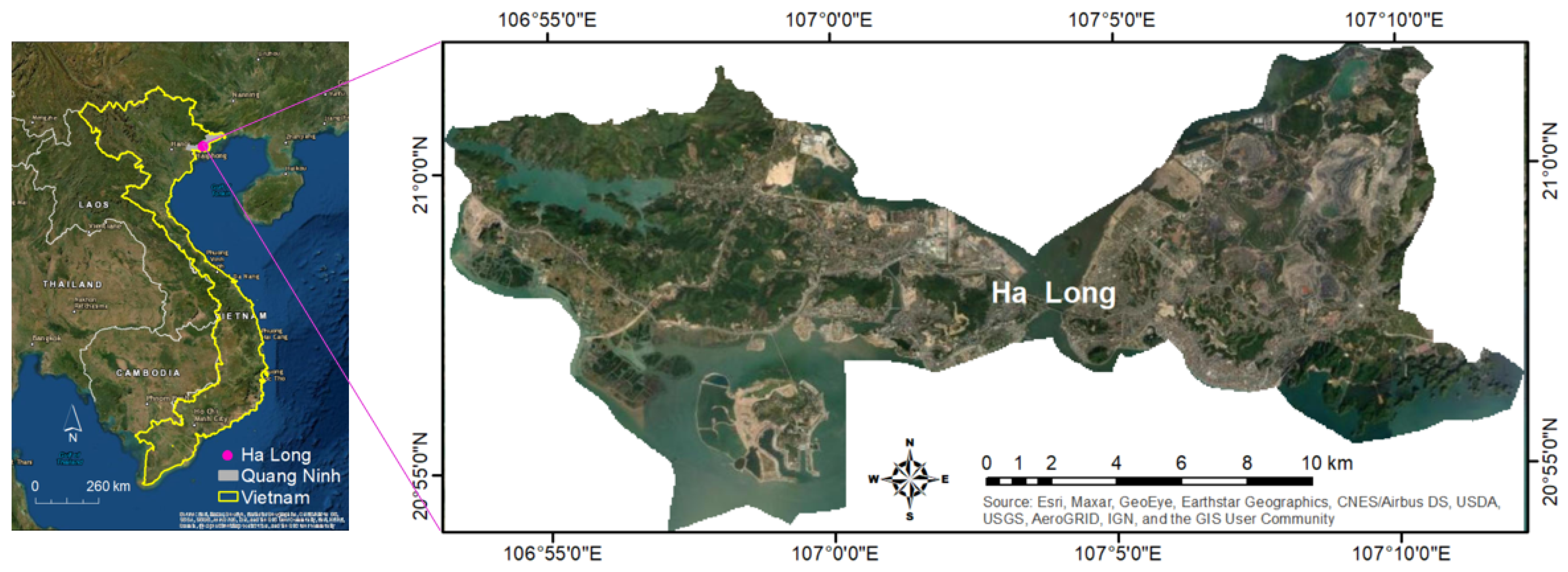
2.1. Study Area
2.2. Data and Methodology
2.2.1. Census Data
2.2.2. Landsat Imagery
2.2.3. Land-Use Classification from Landsat Imagery Using Machine Learning
2.3. Methods for Estimating SDG Indicator for Land-Use Efficiency
- Ln—Natural logarithm;
- Popt—Total population of the area in the past/initial year;
- Popt+n—Total population of the area in the current/final year;
- y—Number of years between the two measurement periods.
- Ln—Natural logarithm;
- Urbt—Total urban built-in area in square km in the past/initial year;
- Urbt+n—Total urban area in square km in the current/final year;
- y—Number of years between the two measurement periods.
3. Results and Discussions
3.1. Verification of Land-Use Classification (or Build-Up Land Area Only) Using Kappa Statistics
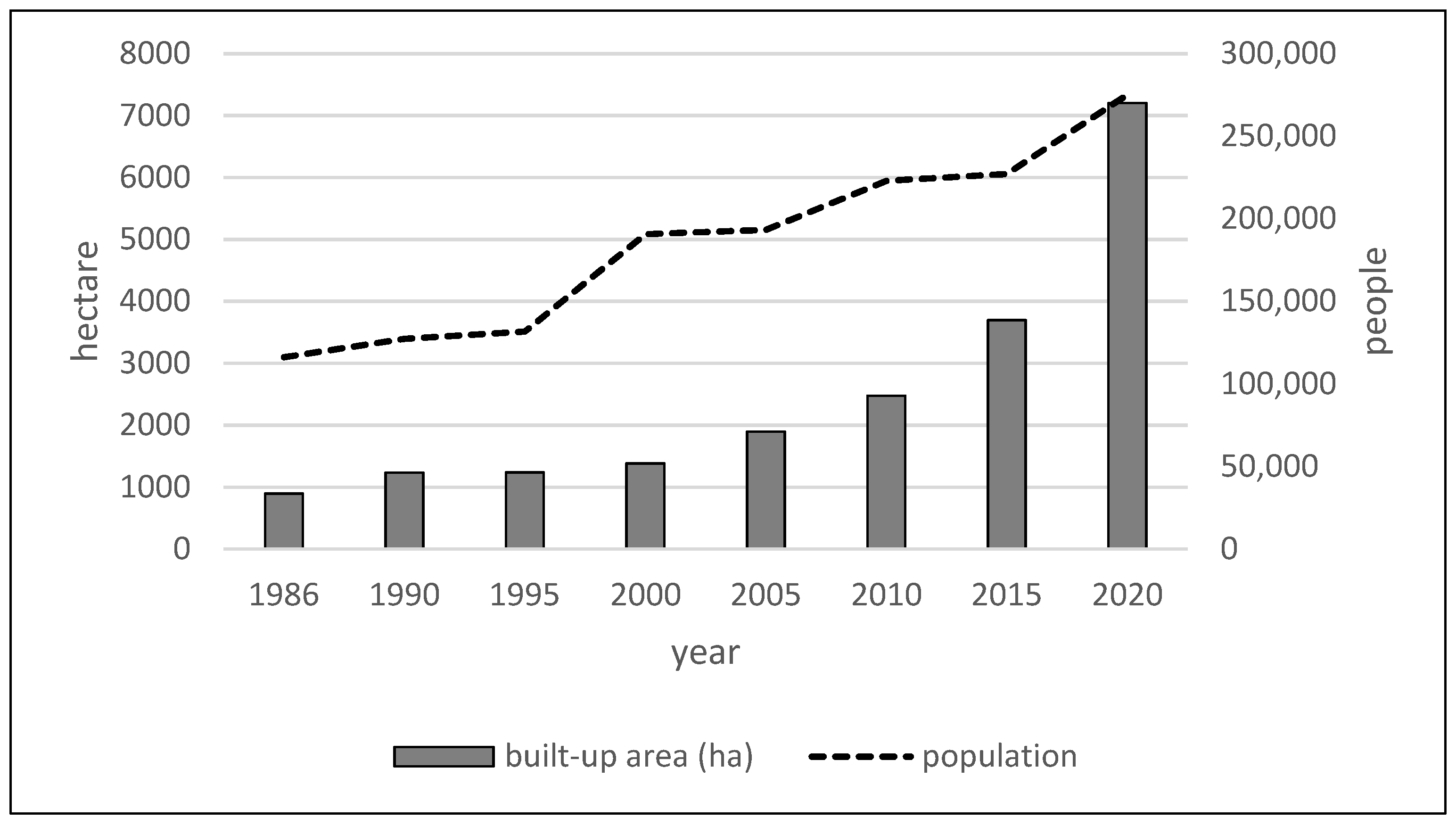
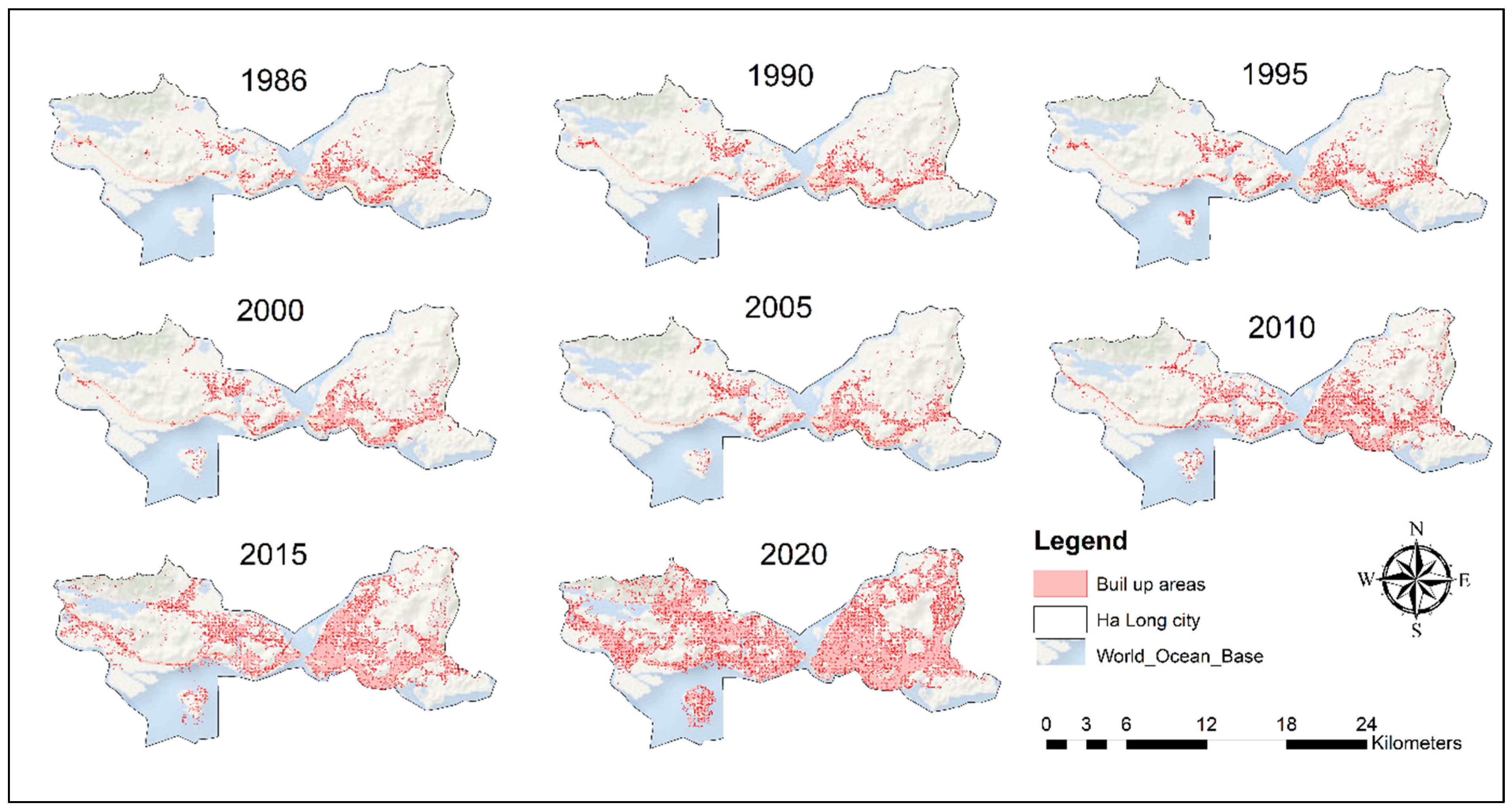
3.2. Land Expansion and Population Growth in Ha Long
3.3. LCR, PGR and LCRPGR Values
4. Conclusions, Limitations, and Future Research
Author Contributions
Funding
Data Availability Statement
Acknowledgments
Conflicts of Interest
References
- Birch, E.L.; Wachter, S.M. World Urbanization: The Critical Issue of the Twenty-First Century. In Global Urbanisation; Birch, E.L., Wachter, S.M., Eds.; University of Pennsylvania Press: Philadelphia, PA, USA, 2011; p. 376. [Google Scholar]
- Word Development Indicators (WDI). The World Bank DataBank. 2021. Available online: https://databank.worldbank.org/source/world-development-indicators (accessed on 21 April 2021).
- Li, C.; Cai, G.; Du, M. Big Data Supported the Identification of Urban Land Efficiency in Eurasia by Indicator SDG 11.3.1. ISPRS Int. J. Geo-Inf. 2021, 10, 64. [Google Scholar] [CrossRef]
- Zoomers, A.; van Noorloos, F.; Otsuki, K.; Steel, G.; van Westen, G. The rush for land in an urbanising world: From land grabbing toward developing safe, resilient, and sustainable cities and landscapes. World Dev. 2017, 92, 242–252. [Google Scholar] [CrossRef]
- Constantin, C.; Luminita, C.; Vasile, A.J. Land grabbing: A review of extent and possible consequences in Romania. Land Use Policy 2017, 62, 143–150. [Google Scholar] [CrossRef]
- Pribadi, D.O.; Pauleit, S. The dynamics of peri-urban agriculture during rapid urbanisation of Jabodetabek metropolitan area. Land Use Policy 2015, 48, 13–24. [Google Scholar] [CrossRef]
- Wang, Y.; Huang, C.; Feng, Y.; Zhao, M.; Gu, J. Using Earth Observation for Monitoring SDG 11.3.1-Ratio of Land Consumption Rate to Population Growth Rate in Mainland China. Remote Sens. 2020, 12, 357. [Google Scholar] [CrossRef] [Green Version]
- Mohajerani, A.; Bakaric, J.; Jeffrey-Bailey, T. The urban heat island effect, its causes, and mitigation, with reference to the thermal properties of asphalt concrete. J. Environ. Manag. 2017, 197, 522–538. [Google Scholar] [CrossRef]
- Zitti, M.; Ferrara, C.; Perini, L.; Carlucci, M.; Salvati, L. Long-term urban growth and land use efficiency in Southern Europe: Implications for sustainable land management. Sustainability 2015, 7, 3359–3385. [Google Scholar] [CrossRef] [Green Version]
- Sustainable Development Goals (SDG) Indicators. Metadata Repository. 2021. Available online: https://unstats.un.org/sdgs/metadata/?Text=&Goal=&Target=11.3 (accessed on 3 June 2021).
- Steiniger, S.; Wagemann, E.; Barrera, F.; Molinos-Senante, M.; Villegas, R.; Fuente, H.; Vives, A.; Arce, G.; Herrera, J.-C.; Carrasco, J.A.; et al. Localising urban sustainability indicators: The GEDEUS indicator set, and lessons from an expert-driven process. Cities 2020, 101, 102683. [Google Scholar] [CrossRef]
- Merino-Saum, A.; Halla, P.; Superti, V.; Boesch, A.; Binder, C.R. Indicators for urban sustainability: Key lessons from a systematic analysis of 67 measurement initiatives. Ecol. Indic. 2020, 119, 106879. [Google Scholar] [CrossRef]
- Koroso, N.K.; Zevenbegen, J.A.; Lengoiboni, M. Urban land use efficiency in Ethiopia: An assessment of urban land use sustainability in Addis Ababa. Land Use Policy 2020, 99, 105081. [Google Scholar] [CrossRef]
- Zhu, X.; Li, Y.; Zhang, P.; Wei, Y.; Zheng, X.; Xie, L. Temporal-spatial characteristics of urban land use efficiency of China’s 35 mega cities based on DEA: Decomposing technology and scale efficiency. Land Use Policy 2019, 88, 104083. [Google Scholar] [CrossRef]
- Shen, X.; Wang, X.; Zhang, Z.; Lu, Z.; Lv, T. Evaluating the effectiveness of land use plans in containing urban expansion: An integrated view. Land Use Policy 2019, 80, 205–213. [Google Scholar] [CrossRef]
- Mwaniki, D. Module 3. Indicator 11.3.1 Land Consumption Rate to Population Growth Rate. Presented at the Regional Training Workshop on Human Settlement Indicators, Bangkok, Thailand, 26–29 March 2018. [Google Scholar]
- Tier Classification for Global SDG Indicators. 2018. Available online: https://unstats.un.org/sdgs/files/Tier%20Classification%20of%20SDG%20Indicators_11%20May%202018_web.pdf (accessed on 26 July 2021).
- Melchiorri, M.; Pesaresi, M.; Florczyk, J.A.; Corbane, C.; Kemper, T. Principles and Applications of the Global Human Settlement Layer as Baseline for the Land Use Efficiency Indicator—SDG 11.3.1. ISPRS Int. J. Geo-Inf. 2019, 8, 96. [Google Scholar] [CrossRef] [Green Version]
- United Nations. The Sustainable Development Goals Report; United Nations: New York, NY, USA, 2016; Available online: https://www.un.org/development/desa/publications/sustainable-development-goals-.report-2016.html (accessed on 2 March 2021).
- Chen, Y.; Guerschman, J.; Shendryk, Y.; Henry, D.; Harrison, M.T. Estimating pasture biomass using Sentinel-2 imagery and deep learning. Remote Sens. 2021, 13, 603. [Google Scholar] [CrossRef]
- Woodcock, C.E.; Allen, R.; Anderson, M.; Belward, A.; Bindschadler, R.; Cohen, W.; Gao, F.; Goward, S.N.; Helder, D.; Helmer, E.; et al. Free Access to Landsat Imagery. Science 2008, 320, 1011. [Google Scholar] [CrossRef] [PubMed]
- Huang, C.; Chen, Y.; Zhang, S.; Wu, J. Detecting, extracting, and monitoring surface water from space using optical sensors: A review. Rev. Geophys. 2018, 56, 333–360. [Google Scholar] [CrossRef]
- Cihlar, J. Land cover mapping of large areas from satellites: Status and research priorities. Int. J. Remote Sens. 2000, 21, 1093–1114. [Google Scholar] [CrossRef]
- Chen, Y.; Gillieson, D. Evaluation of Landsat TM vegetation indices for estimating vegetation cover on semi-arid rangelands a case study from Australia. Can. J. Remote Sens. 2009, 35, 435–446. [Google Scholar] [CrossRef]
- Gong, P.; Wang, J.; Yu, L.; Zhao, Y.; Zhao, Y.; Liang, L.; Niu, Z.; Huang, X.; Fu, H.; Liu, S.; et al. Finer resolution observation and monitoring of global land cover: First mapping results with Landsat TM and ETM+ data. Int. J. Remote Sens. 2013, 34, 2607–2654. [Google Scholar] [CrossRef] [Green Version]
- Tuan, V.Q.; Trung, N.H.; Nguyen, M. An Assessment of Green Space, Blue Space and Green Infrastructure Using Remote Sensing Approach, Research Report No. DMI-0111/2019; DRAGON—Mekong Institute of Climate Change Research, Can Tho University: Cần Thơ, Vietnam, 2019; p. 38. [Google Scholar]
- Abid, A.M. Land cover and land use classification performance of machine learning algorithms in a boreal landscape using sentinel-2 data. GISci. Remote Sens. 2019, 57, 1–20. [Google Scholar] [CrossRef] [Green Version]
- Mountrakis, G.; Im, J.; Ogole, C. Support vector machines in remote sensing: A review. ISPRS J. Photogramm. Remote Sens. 2011, 66, 247–259. [Google Scholar] [CrossRef]
- Pal, M.; Foody, G.M. Feature selection for classification of hyperspectral data by SVM. IEEE Trans. Geosci. Remote Sens. 2010, 48, 2297–2307. [Google Scholar] [CrossRef] [Green Version]
- Heikkonen, J.; Varfis, A. Land cover/land use classification of urban areas: A remote sensing approach. Int. J. Pattern Recognit. Artif. Intell. 1998, 12, 475–489. [Google Scholar] [CrossRef]
- Kotsiantis, S.B.; Zaharakis, I.; Pintelas, P. Supervised Machine Learning: A Review of Classification Techniques. In Emerging Artificial Intelligence Applications in Computer Engineering; IOS Press: Amsterdam, The Netherlands, 2007; Volume 160, pp. 3–24. [Google Scholar]
- Shao, Y.; Lunetta, R.S. Comparison of support vector machine, neural network, and CART algorithms for the land-cover classification using limited training data points. ISPRS J. Photogramm. Remote Sens. 2012, 70, 78–87. [Google Scholar] [CrossRef]
- Breiman, L. Random forests. Mach. Learn. 2001, 45, 5–32. [Google Scholar] [CrossRef] [Green Version]
- Na, X.; Zhang, S.; Li, X.; Yu, H.; Liu, C. Improved land cover mapping using random forests combined with Landsat Thematic Mapper imagery and ancillary geographic data. Photogramm. Eng. Remote Sens. 2010, 76, 833–840. [Google Scholar] [CrossRef]
- Thanh Noi, P.; Kappas, M. Comparison of random forest, k-nearest neighbor, and support vector machine classifiers for land cover classification using sentinel-2 imagery. Sensors 2018, 18, 18. [Google Scholar] [CrossRef] [PubMed] [Green Version]
- Zafari, A.; Zurita-Milla, R.; Izquierdo-Verdiguier, E. Evaluating the performance of a random forest kernel for land cover classification. Remote Sens. 2019, 11, 575. [Google Scholar] [CrossRef] [Green Version]
- Phiri, D.; Morgenroth, J. Developments in Landsat cover classification methods: A review. Remote Sens. 2017, 9, 967. [Google Scholar] [CrossRef] [Green Version]
- Srivastava, P.K.; Han, D.; Rico-Ramirez, M.A.; Bray, M.; Islam, T. Selection of classification techniques for landuse/landcover change investigation. Adv. Space Res. 2012, 50, 1250–1265. [Google Scholar] [CrossRef]
- Ge, G.; Shi, Z.; Zhu, Y.; Yang, X. Land use/cover classification in an arid desert-oasis mosaic landscape of China using remote sensed imagery: Performance assessment of four machine learning algorithms. Glob. Ecol. Conserv. 2020, 22, e00971. [Google Scholar] [CrossRef]
- World Bank (WB). Vietnam’s Urbanisation at a Crossroads: Embarking on an Efficient, Inclusive, and Resilient Pathway. License: CC BY 3.0 IGO. 2020. Available online: https://openknowledge.worldbank.org/handle/10986/34761 (accessed on 26 May 2021).
- National Institute for Urban and Rural Planning (NIURP). City Development Strategy for Halong; Final Report; National Institute for Urban and Rural Planning: Hanoi, Vietnam, 2012; p. 205. [Google Scholar]
- Broemme, K.; Stolpe, H. Developing Environmental Concepts for Vietnamese Coal Mines. Presented at International Workshop Geoecology and Environmental Technology, Hanoi, Vietnam, 25–27 October 2007. [Google Scholar]
- General Statistics Office of Vietnam. Population and Employment Statistics. 2021. Available online: https://www.gso.gov.vn/en/population/ (accessed on 5 April 2021).
- Ben-hur, A.; Horn, D.; Siegelmann, H.T.; Vapnik, V. Support vector clustering. J. Mach. Learn. Res. 2001, 2, 125–137. [Google Scholar] [CrossRef]
- Sheykhmousa, M.; Mahdianpari, M.; Ghanbari, H.; Mohammadimanesh, F.; Ghamisi, P.; Homayouni, S. Support Vector Machine vs. Random Forest for Remote Sensing Image Classification: A Meta-analysis and systematic review. IEEE J. Sel. Top. Appl. Earth Obs. Remote Sens. 2020, 13, 6308–6325. [Google Scholar] [CrossRef]
- Mboga, N.; Persello, C.; Bergado, J.R.; Stein, A. Detection of informal settlements from VHR images using convolutional neural networks. Remote Sens. 2017, 9, 1106. [Google Scholar] [CrossRef] [Green Version]
- Turker, M.; Koc-San, D. Building extraction from high-resolution optical spaceborne images using the integration of support vector machine (SVM) classification, Hough transformation and perceptual grouping. Int. J. Appl. Earth Obs. Geoinf. 2015, 34, 58–69. [Google Scholar] [CrossRef]
- Hsu, C.-W.; Chang, C.-C.; Lin, C.-J. A Practical Guide to Support Vector Classification; National Taiwan University: Taipei, Taiwan, 2003; pp. 1396–1400. [Google Scholar]
- Quang, N.H.; Quinn, C.H.; Stringer, L.C.; Carrie, R.; Hackney, C.R.; Van Hue, L.T.; Van Tan, D.; Nga, P.T.T. Multi-Decadal Changes in Mangrove Extent, Age and Species in the Red River Estuaries of Viet Nam. Remote Sens. 2020, 12, 2289. [Google Scholar] [CrossRef]
- Congalton, R.G. A review of assessing the accuracy of classifications of remotely sensed data. Remote Sens. Environ. 1991, 37, 35–46. [Google Scholar] [CrossRef]
- Congalton, R.G.; Green, K. Assessing the Accuracy of Remotely Sensed Data: Principles and Practices; CRC Press: Boca Raton, FL, USA, 1999. [Google Scholar]
- Chen, Y.; Huang, C.; Ticehurst, C.; Merrin, L.; Thew, P. An evaluation of MODIS daily and 8-day composite products for floodplain and wetland inundation mapping. Wetlands 2013, 33, 823–835. [Google Scholar] [CrossRef]
- Landis, J.R.; Koch, G.G. The measurement of observer agreement for categorical data. Biometrics 1977, 33, 159–174. [Google Scholar] [CrossRef] [Green Version]
- Jensen, J.R. An Introductory Digital Image Processing: A Remote Sensing Perspective; Prentice Hall: New Jersey, NJ, USA, 2005. [Google Scholar]
- UN-Habitat. A Guide to Assist National and Local Governments to Monitor and Report on SDG Goal 11+ Indicators; UN-Habitat: New York, NY, USA, 2018. [Google Scholar]
- EcoWatch. Toxic Floods from Coal Mines and Power Plants Hit Vietnam’s Ha Long Bay World Heritage Site. 2015. Available online: https://www.ecowatch.com/toxic-floods-from-coal-mines-and-power-plants-hit-vietnams-ha-long-bay-1882080179.html (accessed on 1 June 2021).
- New York Times. Vietnam Floods Kill 17 an Threaten to Pollute Ha Long Bay. 2015. Available online: https://www.nytimes.com/2015/07/31/world/asia/vietnam-floods.html (accessed on 1 June 2021).
- Corbane, C.; Politis, P.; Siragusa, A.; Kemper, T.; Pesaresi, M. LUE User Guide: A tool to calculate the Land Use Efficiency and the SDG 11.3 Indicator with the Global Human Settlement Layer; Publications Office of the European Union: Luxembourg, 2017. [Google Scholar]


| Sensor | Band | Acquisition Date |
|---|---|---|
| Landsat 5 | B1–B7 | 30 October 1986 |
| Landsat 5 | B1–B7 | 26 November 1990 |
| Landsat 5 | B1–B7 | 24 November 1995 |
| Landsat 5 | B1–B7 | 21 November 2000 |
| Landsat 5 | B1–B7 | 2 October 2005 |
| Landsat 5 | B1–B7 | 3 December 2010 |
| Landsat 8 | B1–B11 | 15 January 2015 |
| Landsat 8 | B1–B11 | 12 November 2020 |
| Urban Expansion Type | LCRPGR Data Range | Meaning |
|---|---|---|
| Rapid urban land growth | (1–5) | Urban land consumption exceeds population growth |
| Rapid urban population growth | (0–1) | Urban population growth exceeds land consumption |
| Urban shrinking | (−5–0) | Urban population declining or urban land shrinking |
| Ha Long | Samples | Overall Accuracy (%) | Omission Error (%) | Commission Error (%) | Kappa |
|---|---|---|---|---|---|
| 1986 | 115 | 92.25 | 8.50 | 11.60 | 0.91 |
| 1990 | 120 | 83.41 | 9.21 | 20.20 | 0.80 |
| 1995 | 101 | 84.21 | 13.16 | 19.52 | 0.82 |
| 2000 | 125 | 88.24 | 16.64 | 20.24 | 0.86 |
| 2005 | 123 | 86.03 | 17.09 | 22.61 | 0.84 |
| 2010 | 124 | 86.40 | 17.60 | 21.04 | 0.84 |
| 2015 | 124 | 98.91 | 1.91 | 3.03 | 0.99 |
| 2020 | 144 | 95.17 | 9.16 | 4.36 | 0.94 |
| Index | Time Periods | ||||||
|---|---|---|---|---|---|---|---|
| 1986–1990 | 1990–1995 | 1995–2000 | 2000–2005 | 2005–2010 | 2010–2015 | 2015–2020 | |
| LCR | 0.0805 | 0.0002 | 0.0225 | 0.0629 | 0.0534 | 0.0801 | 0.1335 |
| PGR | 0.0230 | 0.0068 | 0.0739 | 0.0028 | 0.0285 | 0.0038 | 0.0383 |
| LCRPGR | 3.50 | 0.02 | 0.30 | 22.50 | 1.87 | 21.32 | 3.48 |
| 1986–2000 | 2000–2020 | ||||||
| LCR | 0.0311 | 0.0825 | |||||
| PGR | 0.0354 | 0.0183 | |||||
| LCRPGR | 0.88 | 4.50 | |||||
Publisher’s Note: MDPI stays neutral with regard to jurisdictional claims in published maps and institutional affiliations. |
© 2021 by the authors. Licensee MDPI, Basel, Switzerland. This article is an open access article distributed under the terms and conditions of the Creative Commons Attribution (CC BY) license (https://creativecommons.org/licenses/by/4.0/).
Share and Cite
Jalilov, S.-M.; Chen, Y.; Quang, N.H.; Nguyen, M.N.; Leighton, B.; Paget, M.; Lazarow, N. Estimation of Urban Land-Use Efficiency for Sustainable Development by Integrating over 30-Year Landsat Imagery with Population Data: A Case Study of Ha Long, Vietnam. Sustainability 2021, 13, 8848. https://doi.org/10.3390/su13168848
Jalilov S-M, Chen Y, Quang NH, Nguyen MN, Leighton B, Paget M, Lazarow N. Estimation of Urban Land-Use Efficiency for Sustainable Development by Integrating over 30-Year Landsat Imagery with Population Data: A Case Study of Ha Long, Vietnam. Sustainability. 2021; 13(16):8848. https://doi.org/10.3390/su13168848
Chicago/Turabian StyleJalilov, Shokhrukh-Mirzo, Yun Chen, Nguyen Hong Quang, Minh Nguyen Nguyen, Ben Leighton, Matt Paget, and Neil Lazarow. 2021. "Estimation of Urban Land-Use Efficiency for Sustainable Development by Integrating over 30-Year Landsat Imagery with Population Data: A Case Study of Ha Long, Vietnam" Sustainability 13, no. 16: 8848. https://doi.org/10.3390/su13168848