
Assessing Land Cover and Ecological Quality Changes under the New-Type Urbanization from Multi-Source Remote Sensing


Abstract
:1. Introduction
2. Materials and Methods
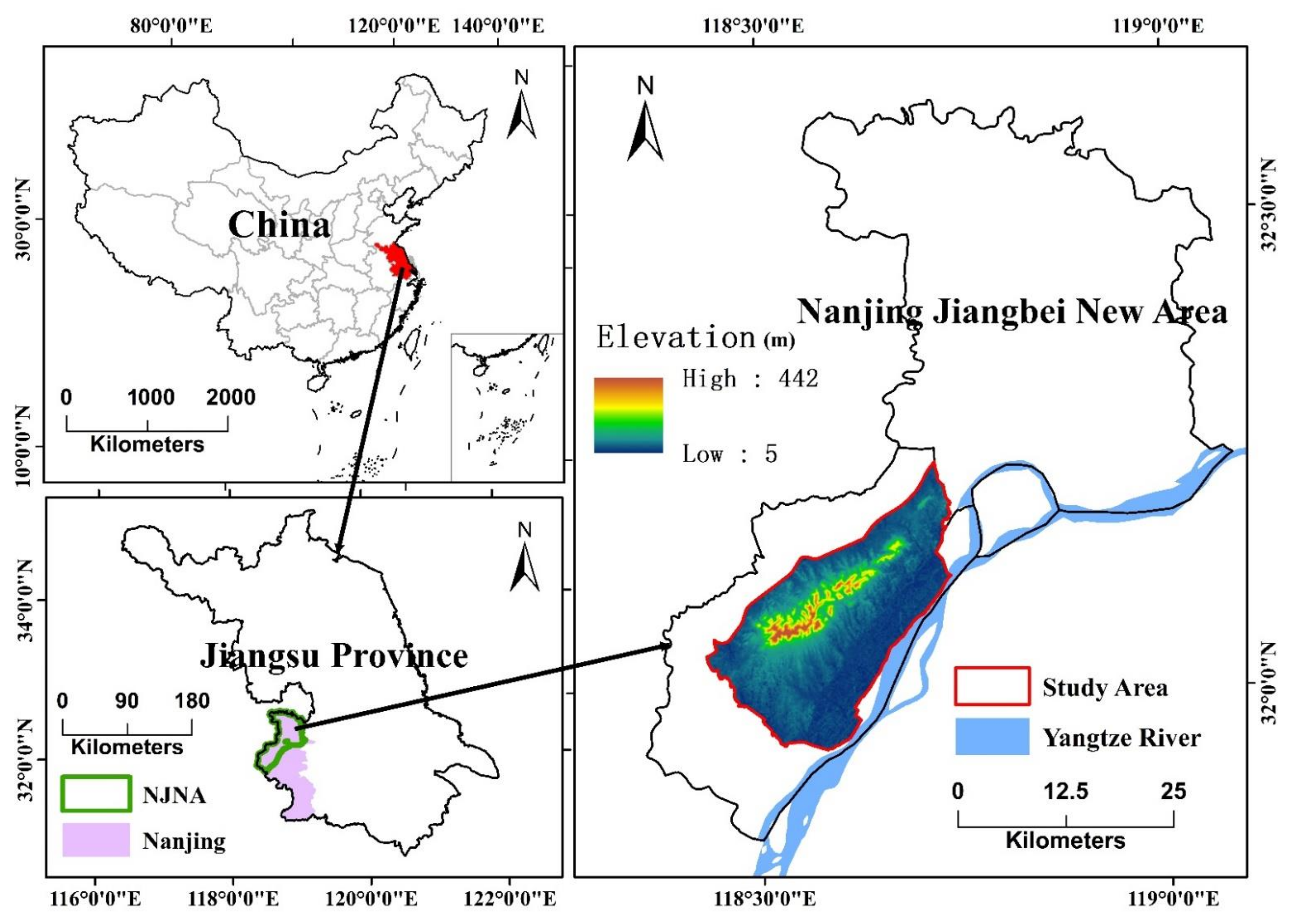
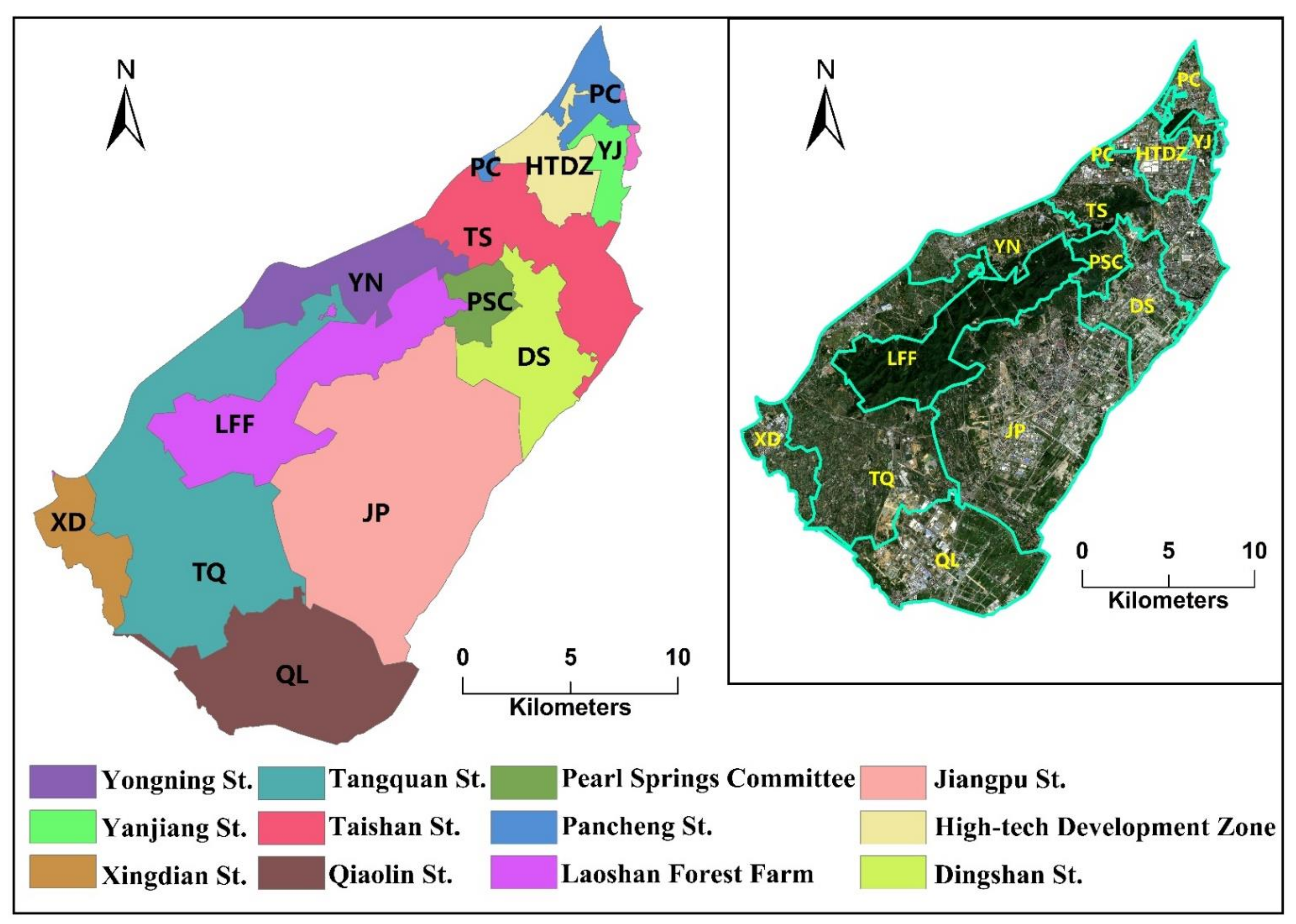
2.1. Study Area
2.2. Data Resources and Image Pre-Processing
2.3. Object-Oriented Land Cover Classification and Accuracy Assessment
2.4. Land Cover Change Analysis
2.5. RSEI Model
2.5.1. Greenness (NDVI)
2.5.2. Wetness
2.5.3. Heat (LST)
2.5.4. Dryness (NDBSI)
2.5.5. Integration of the Four Indicators
2.6. Spatial Auto-Correlation Analysis
2.6.1. Global Spatial Auto-Correlation Analysis
2.6.2. Local Spatial Auto-Correlation Analysis (Hot-Spot Analysis)
3. Results
3.1. Validation of the LC Classifications and the Final Classification Maps
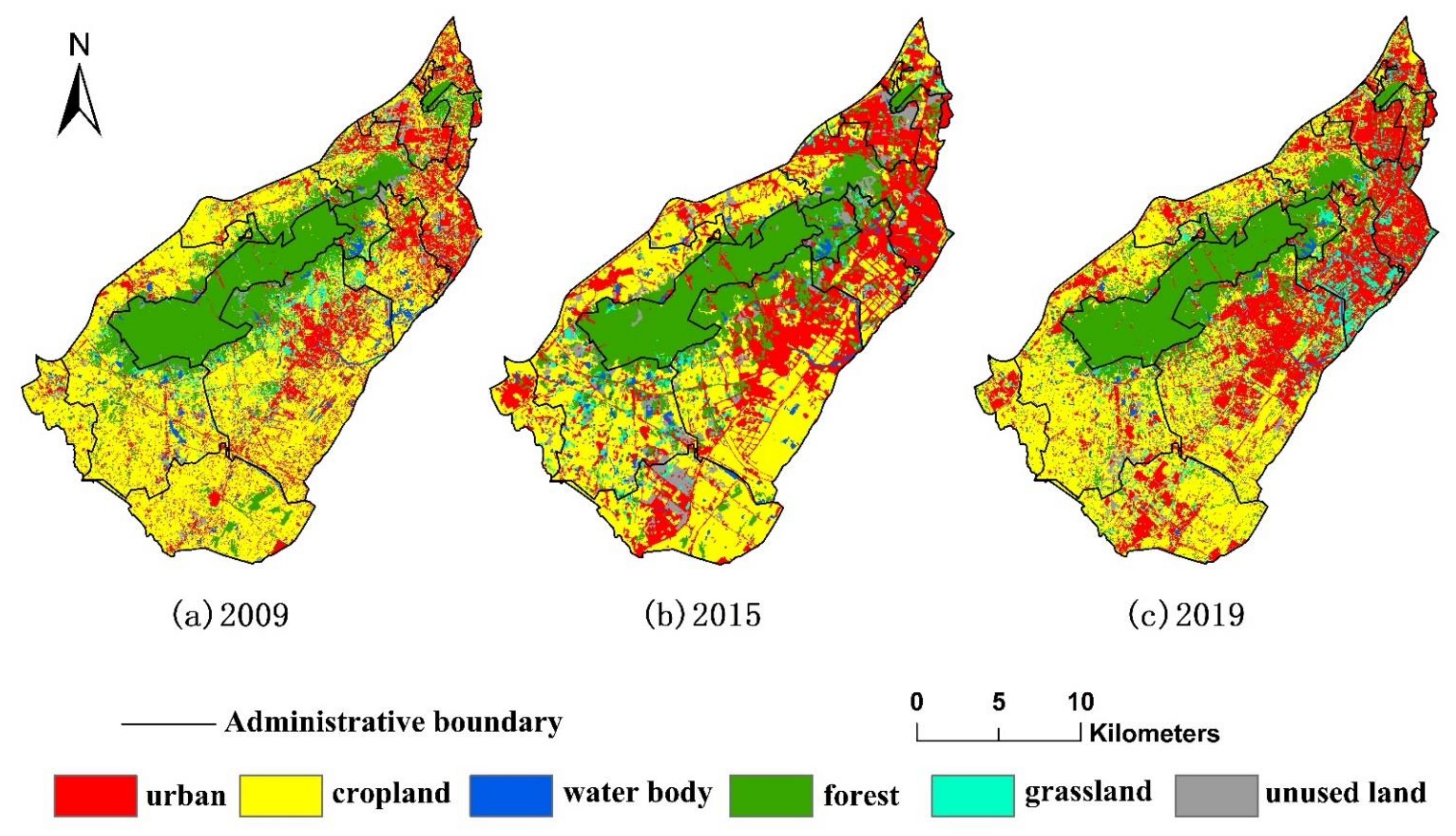
3.2. Spatial-Temporal Conversion Analysis of the Land Cover Types
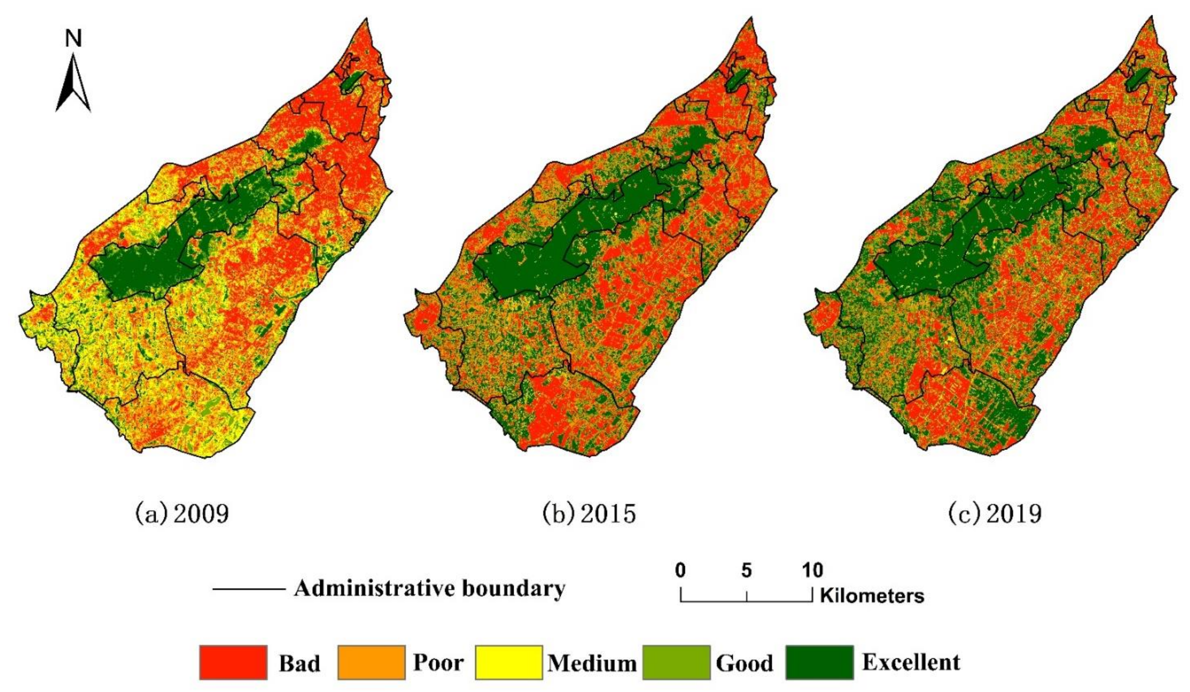
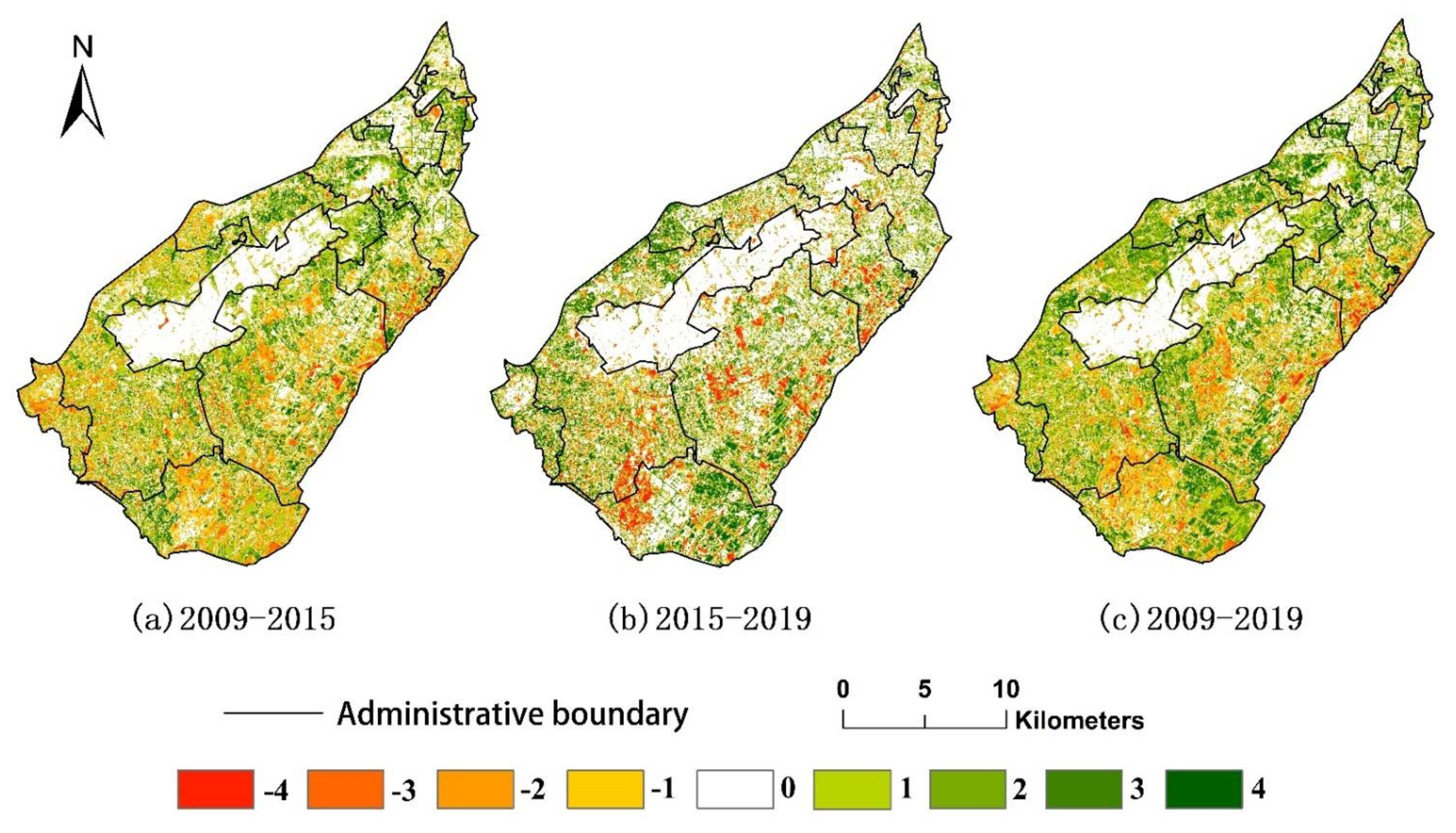
3.3. The Spatio-Temporal Transformation of Ecological Quality
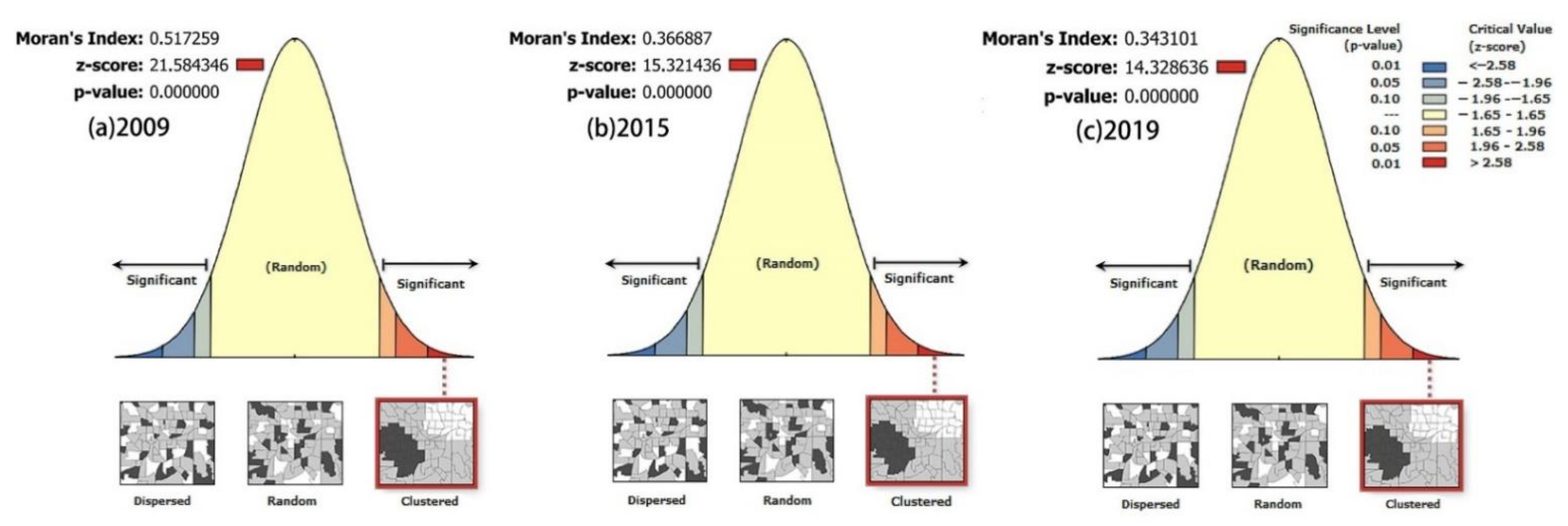
3.4. Spatial Auto-Correlation Analysis
4. Discussion and Policy Implications
4.1. LC and Ecological Quality Changes Resulting from Traditional Urbanization (2009–2015) and NTU (2015–2019)
4.2. Uncertainties and Future Work
5. Conclusions
Author Contributions
Funding
Institutional Review Board Statement
Informed Consent Statement
Data Availability Statement
Conflicts of Interest
References
- Lambin, E.; Rounsevell, M.; Geist, H. Are agricultural land-use models able to predict changes in land-use intensity? Agric. Ecosyst. Environ. 2000, 82, 321–331. [Google Scholar] [CrossRef]
- Cai, Y.-B.; Li, H.-M.; Ye, X.-Y.; Zhang, H. Analyzing Three-Decadal Patterns of Land Use/Land Cover Change and Regional Ecosystem Services at the Landscape Level: Case Study of Two Coastal Metropolitan Regions, Eastern China. Sustainability 2016, 8, 773. [Google Scholar] [CrossRef] [Green Version]
- He, X.; Liang, J.; Zeng, G.; Yuan, Y.; Li, X. The Effects of Interaction between Climate Change and Land-Use/Cover Change on Biodiversity-Related Ecosystem Services. Glob. Chall. 2019, 3, 1800095. [Google Scholar] [CrossRef] [PubMed] [Green Version]
- Lin, M.; Lin, T.; Sun, C.; Jones, L.; Sui, J.; Zhao, Y.; Liu, J.; Xing, L.; Ye, H.; Zhang, G.; et al. Using the Eco-Erosion Index to assess regional ecological stress due to urbanization—A case study in the Yangtze River Delta urban agglomeration. Ecol. Indic. 2019, 111, 106028. [Google Scholar] [CrossRef]
- Xu, H.; Wang, M.; Shi, T.; Guan, H.; Fang, C.; Lin, Z. Prediction of ecological effects of potential population and impervious surface increases using a remote sensing based ecological index (RSEI). Ecol. Indic. 2018, 93, 730–740. [Google Scholar] [CrossRef]
- Chen, M.; Liu, W.; Lu, D.; Chen, H.; Ye, C. Progress of China’s new-type urbanization construction since 2014: A preliminary assessment. Cities 2018, 78, 180–193. [Google Scholar] [CrossRef]
- Li, H.; Song, W. Evolution of rural settlements in the Tongzhou District of Beijing under the new-type urbanization policies. Habitat Int. 2020, 101, 102198. [Google Scholar] [CrossRef]
- Yao, X.; Kou, D.; Shao, S.; Li, X.; Wang, W.; Zhang, C. Can urbanization process and carbon emission abatement be harmonious? New evidence from China. Environ. Impact Assess. Rev. 2018, 71, 70–83. [Google Scholar] [CrossRef]
- Deng, S. Exploring the relationship between new-type urbanization and sustainable urban land use: Evidence from prefecture-level cities in China. Sustain. Comput. Inform. Syst. 2020, 30, 100446. [Google Scholar] [CrossRef]
- Zhao, Z.; Bai, Y.; Wang, G.; Chen, J.; Yu, J.; Liu, W. Land eco-efficiency for new-type urbanization in the Beijing-Tianjin-Hebei Region. Technol. Forecast. Soc. Chang. 2018, 137, 19–26. [Google Scholar] [CrossRef]
- Zhao, Y.; Wang, S.; Zhou, C. Understanding the relation between urbanization and the eco-environment in China’s Yangtze River Delta using an improved EKC model and coupling analysis. Sci. Total. Environ. 2016, 571, 862–875. [Google Scholar] [CrossRef]
- Shen, W.; Mao, X.; He, J.; Dong, J.; Huang, C.; Li, M. Understanding Current and Future Fragmentation Dynamics of Urban Forest Cover in the Nanjing Laoshan Region of Jiangsu, China. Remote. Sens. 2020, 12, 155. [Google Scholar] [CrossRef] [Green Version]
- Lü, Y.; Ma, Z.; Zhang, L.; Fu, B.; Gao, G. Redlines for the greening of China. Environ. Sci. Policy 2013, 33, 346–353. [Google Scholar] [CrossRef]
- Yang, J.; Li, Y.; Hay, I.; Huang, X. Decoding national new area development in China: Toward new land development and politics. Cities 2019, 87, 114–120. [Google Scholar] [CrossRef]
- Kabisch, N.; Selsam, P.; Kirsten, T.; Lausch, A.; Bumberger, J. A multi-sensor and multi-temporal remote sensing approach to detect land cover change dynamics in heterogeneous urban landscapes. Ecol. Indic. 2018, 99, 273–282. [Google Scholar] [CrossRef]
- Zhu, X.; Liu, D. Improving forest aboveground biomass estimation using seasonal Landsat NDVI time-series. ISPRS J. Photogramm. Remote. Sens. 2015, 102, 222–231. [Google Scholar] [CrossRef]
- Duro, D.; Franklin, S.; Dubé, M.G. A comparison of pixel-based and object-based image analysis with selected machine learning algorithms for the classification of agricultural landscapes using SPOT-5 HRG imagery. Remote. Sens. Environ. 2012, 118, 259–272. [Google Scholar] [CrossRef]
- Batista, M.H.; Haertel, V. On the classification of remote sensing high spatial resolution image data. Int. J. Remote. Sens. 2010, 31, 5533–5548. [Google Scholar] [CrossRef]
- Hu, Q.; Wu, W.; Xia, T.; Yu, Q.; Yang, P.; Li, Z.; Song, Q. Exploring the Use of Google Earth Imagery and Object-Based Methods in Land Use/Cover Mapping. Remote. Sens. 2013, 5, 6026–6042. [Google Scholar] [CrossRef] [Green Version]
- Rizvi, I.A.; Mohan, B.K. Improving the accuracy of object based supervised image classification using cloud basis function neural network for high resolution satellite images. Image Process. 2010, 4, 342–353. [Google Scholar]
- Rizvi, I.A.; Mohan, B.K. Object-Based Image Analysis of High-Resolution Satellite Images Using Modified Cloud Basis Function Neural Network and Probabilistic Relaxation Labeling Process. IEEE Trans. Geosci. Remote. Sens. 2011, 49, 4815–4820. [Google Scholar] [CrossRef]
- Blaschke, T. A framework for change detection based on image objects. Göttinger Geogr. Abh. 2005, 113, 1–9. [Google Scholar]
- Blaschke, T. Object based image analysis for remote sensing. ISPRS J. Photogramm. Remote. Sens. 2010, 65, 2–16. [Google Scholar] [CrossRef] [Green Version]
- Chen, Y.; Jiang, H.; Li, C.; Jia, X.; Ghamisi, P. Deep Feature Extraction and Classification of Hyperspectral Images Based on Convolutional Neural Networks. IEEE Trans. Geosci. Remote. Sens. 2016, 54, 6232–6251. [Google Scholar] [CrossRef] [Green Version]
- Zhao, W.; Du, S.; Emery, W.J. Object-Based Convolutional Neural Network for High-Resolution Imagery Classification. IEEE J. Sel. Top. Appl. Earth Obs. Remote. Sens. 2017, 10, 3386–3396. [Google Scholar] [CrossRef]
- LeCun, Y.; Bengio, Y.; Hinton, G. Deep learning. Nature 2015, 521, 436–444. [Google Scholar] [CrossRef]
- Ma, L.; Liu, Y.; Zhang, X.; Ye, Y.; Yin, G.; Johnson, B.A. Deep learning in remote sensing applications: A meta-analysis and review. ISPRS J. Photogramm. Remote. Sens. 2019, 152, 166–177. [Google Scholar] [CrossRef]
- Maggiori, E.; Tarabalka, Y.; Charpiat, G.; Alliez, P. Convolutional Neural Networks for Large-Scale Remote-Sensing Image Classification. IEEE Trans. Geosci. Remote. Sens. 2016, 55, 645–657. [Google Scholar] [CrossRef] [Green Version]
- Willis, K.S. Remote sensing change detection for ecological monitoring in United States protected areas. Biol. Conserv. 2015, 182, 233–242. [Google Scholar] [CrossRef]
- Zhou, D.; Zhao, S.; Liu, S.; Zhang, L.; Zhu, C. Surface urban heat island in China’s 32 major cities: Spatial patterns and drivers. Remote. Sens. Environ. 2014, 152, 51–61. [Google Scholar] [CrossRef]
- Ivits, E.; Cherlet, M.; Mehl, W.; Sommer, S. Estimating the ecological status and change of riparian zones in Andalusia assessed by multi-temporal AVHHR datasets. Ecol. Indic. 2009, 9, 422–431. [Google Scholar] [CrossRef]
- Murray, N.J.; Keith, D.A.; Bland, L.M.; Ferrari, R.; Lyons, M.B.; Lucas, R.; Pettorelli, N.; Nicholson, E. The role of satellite remote sensing in structured ecosystem risk assessments. Sci. Total Environ. 2018, 619-620, 249–257. [Google Scholar] [CrossRef] [PubMed] [Green Version]
- Hu, X.; Xu, H. A new remote sensing index for assessing the spatial heterogeneity in urban ecological quality: A case from Fuzhou City, China. Ecol. Indic. 2018, 89, 11–21. [Google Scholar] [CrossRef]
- Xu, H. A remote sensing urban ecological index and its application. Acta Ecol. Sin. 2013, 24, 7853–7862. [Google Scholar]
- Yuan, F.; Bauer, M.E. Comparison of impervious surface area and normalized difference vegetation index as indicators of surface urban heat island effects in Landsat imagery. Remote. Sens. Environ. 2006, 106, 375–386. [Google Scholar] [CrossRef]
- Gupta, K.; Kumar, P.; Pathan, S.; Sharma, K. Urban Neighborhood Green Index—A measure of green spaces in urban areas. Landsc. Urban Plan. 2012, 105, 325–335. [Google Scholar] [CrossRef]
- Hang, X.; Li, Y.; Luo, X.; Xu, M.; Han, X. Assessing the Ecological Quality of Nanjing during Its Urbanization Process by Using Satellite, Meteorological, and Socioeconomic Data. J. Meteorol. Res. 2020, 34, 280–293. [Google Scholar] [CrossRef]
- Yue, H.; Liu, Y.; Li, Y.; Lu, Y. Eco-Environmental Quality Assessment in China’s 35 Major Cities Based on Remote Sensing Ecological Index. IEEE Access 2019, 7, 51295–51311. [Google Scholar] [CrossRef]
- Shan, W.; Jin, X.; Ren, J.; Wang, Y.; Xu, Z.; Fan, Y.; Gu, Z.; Hong, C.; Lin, J.; Zhou, Y. Ecological environment quality assessment based on remote sensing data for land consolidation. J. Clean. Prod. 2019, 239, 118126. [Google Scholar] [CrossRef]
- Ariken, M.; Zhang, F.; Liu, K.; Fang, C.; Kung, H.-T. Coupling coordination analysis of urbanization and eco-environment in Yanqi Basin based on multi-source remote sensing data. Ecol. Indic. 2020, 114, 106331. [Google Scholar] [CrossRef]
- European Space Agency. Available online: https://www.esa.int/ (accessed on 15 March 2021).
- Gong, P.; Chen, B.; Li, X.; Liu, H.; Wang, J.; Bai, Y.; Chen, J.; Chen, X.; Fang, L.; Feng, S.; et al. Mapping essential urban land use categories in China (EULUC-China): Preliminary results for 2018. Sci. Bull. 2019, 65, 182–187. [Google Scholar] [CrossRef] [Green Version]
- Drǎguţ, L.; Tiede, D.; Levick, S. ESP: A tool to estimate scale parameter for multiresolution image segmentation of remotely sensed data. Int. J. Geogr. Inf. Sci. 2010, 24, 859–871. [Google Scholar] [CrossRef]
- Drăguţ, L.; Csillik, O.; Eisank, C.; Tiede, D. Automated parameterisation for multi-scale image segmentation on multiple layers. ISPRS J. Photogramm. Remote. Sens. 2013, 88, 119–127. [Google Scholar] [CrossRef] [PubMed] [Green Version]
- Abdullah, A.Y.M.; Masrur, A.; Adnan, M.S.G.; Al Baky, A.; Hassan, Q.K.; Dewan, A. Spatio-temporal Patterns of Land Use/Land Cover Change in the Heterogeneous Coastal Region of Bangladesh between 1990 and 2017. Remote. Sens. 2019, 11, 790. [Google Scholar] [CrossRef] [Green Version]
- Rimal, B.; Zhang, L.; Keshtkar, H.; Haack, B.N.; Rijal, S.; Zhang, P. Land Use/Land Cover Dynamics and Modeling of Urban Land Expansion by the Integration of Cellular Automata and Markov Chain. ISPRS Int. J. Geo-Inf. 2018, 7, 154. [Google Scholar] [CrossRef] [Green Version]
- Hishe, S.; Bewket, W.; Nyssen, J.; Lyimo, J. Analysing past land use land cover change and CA-Markov-based future modelling in the Middle Suluh Valley, Northern Ethiopia. Geocarto Int. 2019, 35, 225–255. [Google Scholar] [CrossRef]
- Crist, E.P. A TM Tasseled Cap equivalent transformation for reflectance factor data. Remote. Sens. Environ. 1985, 17, 301–306. [Google Scholar] [CrossRef]
- Yarbrough, L.D.; Easson, G.; Kuszmaul, J.S. Using at-sensor radiance and reflectance tasseled cap transforms applied to change detection for the ASTER sensor. IEEE 2005, 141–145. [Google Scholar] [CrossRef]
- Zhang, X.; Schaaf, C.B.; Friedl, M.A.; Strahler, A.H.; Gao, F.; Hodges, J.C.F. MODIS tasseled cap transformation and its utility. Int. Geosci. Remote Sens. Symp. 2002, 2, 1063–1065. [Google Scholar] [CrossRef]
- United States Geological Survey (USGS). Landsat 8 Data Users Hand Book; Geological Survey, Department of the Interior: Reston, VA, USA, 2016.
- Liu, G.; Zhang, Q.; Li, G.; Doronzo, D.M. Response of land cover types to land surface temperature derived from Landsat-5 TM in Nanjing Metropolitan Region, China. Environ. Earth Sci. 2016, 75, 1386. [Google Scholar] [CrossRef]
- Sobrino, J.A.; Jiménez-Muñoz, J.C.; Paolini, L. Land surface temperature retrieval from LANDSAT TM 5. Remote. Sens. Environ. 2004, 90, 434–440. [Google Scholar] [CrossRef]
- Rikimaru, A.; Roy, P.S.; Miyatake, S. Tropical forest cover density mapping. Trop. Ecol. 2002, 43, 39–47. [Google Scholar]
- Xu, H. A new index for delineating built-up land features in satellite imagery. Int. J. Remote. Sens. 2008, 29, 4269–4276. [Google Scholar] [CrossRef]
- Getis, A.; Ord, J.K. The analysis of spatial association by use of distance statistics. Geogr. Anal. 2010, 24, 189–206. [Google Scholar] [CrossRef]
- Anselin, L. Local Indicators of Spatial Association-LISA. Geogr. Anal. 2010, 27, 93–115. [Google Scholar] [CrossRef]
- Unwin, D.J. GIS, spatial analysis and spatial statistics. Prog. Hum. Geogr. 1996, 20, 540–551. [Google Scholar] [CrossRef]
- Ord, J.K.; Getis, A. Local Spatial Autocorrelation Statistics: Distributional Issues and an Application. Geogr. Anal. 1995, 27, 286–306. [Google Scholar] [CrossRef]
- Yu, B. Ecological effects of new-type urbanization in China. Renew. Sustain. Energy Rev. 2020, 135, 110239. [Google Scholar] [CrossRef]
- Xu, F.; Wang, Z.; Chi, G.; Zhang, Z. The impacts of population and agglomeration development on land use intensity: New evidence behind urbanization in China. Land Use Policy 2020, 95, 104639. [Google Scholar] [CrossRef]
- Lai, Z.; Chen, M.; Liu, T. Changes in and prospects for cultivated land use since the reform and opening up in China. Land Use Policy 2020, 97, 104781. [Google Scholar] [CrossRef]
- Liu, Y.; Li, J.T.; Yang, Y. Strategic adjustment of land use policy under the economic transformation. Land Use Policy 2018, 74, 5–14. [Google Scholar] [CrossRef]
- Shen, S. Dynamic simulation of urban green space evolution based on Camarkov model-a case study of Hexi new town of Nanjing city, China. Appl. Ecol. Environ. Res. 2019, 17. [Google Scholar] [CrossRef]
- Khelifi, L.; Mignotte, M. Deep Learning for Change Detection in Remote Sensing Images: Comprehensive Review and Meta-Analysis. IEEE Access 2020, 8, 126385–126400. [Google Scholar] [CrossRef]
- Wan, J.; Su, Y.; Zan, H.; Zhao, Y.; Zhang, L.-Q.; Zhang, S.; Dong, X.; Deng, W. Land Functions, Rural Space Governance, and Farmers’ Environmental Perceptions: A Case Study from the Huanjiang Karst Mountain Area, China. Land 2020, 9, 134. [Google Scholar] [CrossRef]


| Satellites | Acquisition Date | Bands | Spatial Resolution (Pan/Multi-Spectral, m) |
|---|---|---|---|
| RapidEye | 25 Jun 2009 | Blue, Green, Red, Red edge, Near infrared | none, 5 |
| GF-1 WFV4 | 3 Aug 2015 | Blue, Green, Red, Near infrared | none, 16 |
| Sentinel-2A | 19 Sep 2019 | Blue, Green, Red, Red edge, Near infrared, Shortwave infrared | none, 10 |
| Landsat 5 TM | 13 Jun 2009 | Blue, Green, Red, Near infrared, Shortwave infrared, Longwave infrared | none, 30 |
| Landsat 8 OLI/TIRS | 14 Jun 2015 13 Sep 2019 | Blue, Green, Red, Near infrared, Shortwave infrared, Longwave infrared | 15, 30 |
| Sensor | Gain | Bias | K1 (W·m−2·sr−1·μm−1) | K2 (K) |
|---|---|---|---|---|
| TM (band 6) | 0.055 | 1.18243 | 607.76 | 1260.56 |
| TIRS (band 10) | 3.342 × 10⁻⁴ | 0.1 | 774.89 | 1321.08 |
| Dataset | Segmentation Scale | Shape | Compactness | Overall Accuracy (%) | Kappa Coefficient |
|---|---|---|---|---|---|
| RapidEye | 67 | 0.2 | 0.5 | 90.75 | 0.88 |
| GF-1 WFV4 | 77 | 0.2 | 0.6 | 91.75 | 0.90 |
| Sentinel-2A | 65 | 0.4 | 0.6 | 92.04 | 0.90 |
| Final | Urban | Cropland | Water Body | Forest | Grassland | Unused Land | ||
|---|---|---|---|---|---|---|---|---|
| Initial | ||||||||
| 2009–2019 (km2) 2009–2015 (%) | urban | 116.09 (39.86) | 47.72 (42.23) | 3.67 (54.50) | 10.67 (49.95) | 13.02 (34.95) | 4.65 (48.82) | |
| cropland | 74.67 (63.49) | 223.11 (55.16) | 3.67 (72.16) | 33.75 (53.21) | 30.91 (48.04) | 13.29 (58.62) | ||
| water body | 6.01 (80.20) | 7.12 (54.21) | 8.16 (48.41) | 1.70 (47.65) | 1.31 (48.09) | 0.78 (46.15) | ||
| forest | 13.79 (39.88) | 27.39 (40.64) | 0.83 (66.27) | 148.87 (50.14) | 7.60 (52.24) | 3.58 (57.82) | ||
| grassland | 9.00 (63.33) | 8.98 (32.96) | 1.37 (35.77) | 3.89 (45.76) | 3.63 (49.59) | 0.81 (40.74) | ||
| unused land | 15.40 (35.32) | 15.40 (31.10) | 0.65 (46.15) | 6.00 (61.33) | 3.88 (33.25) | 2.30 (43.91) | ||
| Area/km2 | 2009 | 80.67 | 214.31 | 14.52 | 97.81 | 16.65 | 13.17 | |
| 2015 | 115.74 | 166.21 | 10.68 | 104.21 | 13.84 | 27.12 | ||
| 2019 | 119.93 | 164.63 | 7.93 | 100.67 | 33.39 | 11.62 | ||
| Annual change rate (%) | 2009–2015 | 7.24 | −3.74 | −4.41 | 1.09 | −2.82 | 17.64 | |
| 2015–2019 | 0.91 | −0.24 | −6.44 | −0.85 | 35.31 | −14.29 | ||
| Indicator | PC1 | Mean | ||||
|---|---|---|---|---|---|---|
| 2009 | 2015 | 2019 | 2009 | 2015 | 2019 | |
| NDVI | 0.066 | 0.042 | 0.08 | 0.706 | 0.731 | 0.795 |
| Wet | 0.457 | 0.272 | 0.96 | 0.463 | 0.516 | 0.507 |
| LST | −0.197 | −0.126 | −0.545 | 0.654 | 0.631 | 0.58 |
| NDBSI | −0.193 | −0.135 | −0.728 | 0.431 | 0.474 | 0.631 |
| Eigenvalues | 0.267 | 0.358 | 0.322 | |||
| Eigenvalue contribution (%) | 66.4 | 61.02 | 56.37 | |||
| RESI | 0.583 | 0.559 | 0.579 | |||
| RSEI Level | 2009 | 2015 | 2019 | |||
|---|---|---|---|---|---|---|
| Area/km2 | Proportion/% | Area/km2 | Proportion/% | Area/km2 | Proportion/% | |
| Bad (0–0.2) | 109.77 | 25.10 | 136.34 | 31.18 | 122.44 | 28.00 |
| Poor (0.2–0.4) | 111.14 | 25.42 | 91.53 | 20.93 | 61.33 | 14.03 |
| Medium (0.4–0.6) | 95.87 | 21.92 | 9.79 | 2.24 | 17.86 | 4.08 |
| Good (0.6–0.8) | 53.04 | 12.13 | 57.71 | 13.20 | 80.46 | 18.40 |
| Excellent (0.8–1.0) | 67.45 | 15.43 | 141.89 | 32.45 | 155.17 | 35.49 |
| Change | Level Change | 2009–2015 | 2015–2019 | 2019–2009 | |||
|---|---|---|---|---|---|---|---|
| Area/km2 | Proportion/% | Area/km2 | Proportion/% | Area/km2 | Proportion/% | ||
| Deterioration | −4 | 3.50 | 27.91 | 13.61 | 20.59 | 3.83 | 24.62 |
| −3 | 10.94 | 21.53 | 10.48 | ||||
| −2 | 36.43 | 12.34 | 32.82 | ||||
| −1 | 71.18 | 42.53 | 60.51 | ||||
| Invariability | 0 | 150.69 | 34.46 | 212.93 | 48.7 | 136.40 | 31.19 |
| Amelioration | 1 | 73.35 | 37.63 | 43.84 | 30.72 | 72.56 | 44.19 |
| 2 | 45.09 | 35.21 | 62.77 | ||||
| 3 | 37.01 | 41.77 | 49.14 | ||||
| 4 | 9.07 | 13.5 | 14.22 | ||||
| Year | Pukou District | Nanjing City | |||||
|---|---|---|---|---|---|---|---|
| Per Capita Disposable Income of Urban Residents (Yuan) | Rural Economic Conditions (10,000 People) | Per Capita Green Area (m2) | Green Coverage Rate in Built-Up Area (%) | Green Coverage Area (hm2) | |||
| Total Registered Population | Agriculture, Forestry, Animal Husbandry, and Fishery Employees | Number of Industrial Employees | |||||
| 2009 | 23,542 | 54.87 | 2.61 | 4.07 | |||
| 2010 | 13.69 | 44.38 | 84,848 | ||||
| 2015 | 43,687 | 64.28 | 2.06 | 4.2 | 15.1 | 44.47 | 96,874 |
| 2019 | 59,807 | 76.49 | 1.71 | 2.79 | 15.7 | 45.16 | 101,327 |
Publisher’s Note: MDPI stays neutral with regard to jurisdictional claims in published maps and institutional affiliations. |
© 2021 by the authors. Licensee MDPI, Basel, Switzerland. This article is an open access article distributed under the terms and conditions of the Creative Commons Attribution (CC BY) license (https://creativecommons.org/licenses/by/4.0/).
Share and Cite
Shi, F.; Li, M. Assessing Land Cover and Ecological Quality Changes under the New-Type Urbanization from Multi-Source Remote Sensing. Sustainability 2021, 13, 11979. https://doi.org/10.3390/su132111979
Shi F, Li M. Assessing Land Cover and Ecological Quality Changes under the New-Type Urbanization from Multi-Source Remote Sensing. Sustainability. 2021; 13(21):11979. https://doi.org/10.3390/su132111979
Chicago/Turabian StyleShi, Fang, and Mingshi Li. 2021. "Assessing Land Cover and Ecological Quality Changes under the New-Type Urbanization from Multi-Source Remote Sensing" Sustainability 13, no. 21: 11979. https://doi.org/10.3390/su132111979