Abstract
Public works’ relationship with the landscape should be among the factors addressed in heritage studies. Their association with place defines their purpose while contributing to the construction of the cultural landscape. Unawareness of the existence of public works is their most powerful enemy. Inventorying and cataloguing are therefore imperative in any study of these assets. The research described here drew from information technologies to develop cost-free mobile apps in an innovative approach to dissemination with the aim to enhance public awareness of and esteem for such elements. The applications described, which are all author-developed and designed to promote Spain’s heritage public works, address the heritage value of rural public works (VAPROP_Rutas), geolocation of the built heritage (GEOPACK), heritage public works on the River Duero (PHDuero), major works of engineering (GOING) and geolocation of Eduardo Torroja’s public works (underway). All these applications build on the geo-positioning features of mobile handsets and are characterised by simple and intuitive interfaces for ready accessibility by the public at large. Users may participate in the experience by entering useful information, new content and suggestions. These apps deploy the latest technologies to enhance the understanding and appreciation of civil works by explaining their territorial, social and cultural significance.
1. Introduction
In light of its territorial significance, civil engineering is essential to the composition of the cultural landscape, whose interpretation, if broached from that perspective, may shed light on other natural, artificial and socio-cultural dimensions as well.
Unlike architectural heritage, which has been the object of years of research by various schools of thought, public works, such as roads, canals, dams or ports, are poorly delimited and scantly explored and their fundamentals have been insufficiently developed. Their protection and acknowledgement have traditionally been limited to large structures that are erroneously likened to historic-artistic monuments, ignoring factors such as their technological or social dimensions. Until well into the second half of the twentieth century, only engineering works regarded as exceptional further to classical criteria merited attention [1,2]. Until that time, significant (necessarily pre-Industrial Revolution) civil works were deemed to form part of the archaeological or architectural heritage. That changed in the 1970s with the onset of the earliest European movements calling for the acknowledgement of the historic values of the Industrial Revolution [3] and the appearance of so-called industrial archaeology. Even today, however, such problems can still be detected in the Spanish Cultural Heritage Institute’s national plans, in which public works are scattered across several other categories: the industrial heritage, cultural landscape and twentieth-century heritage [4,5].
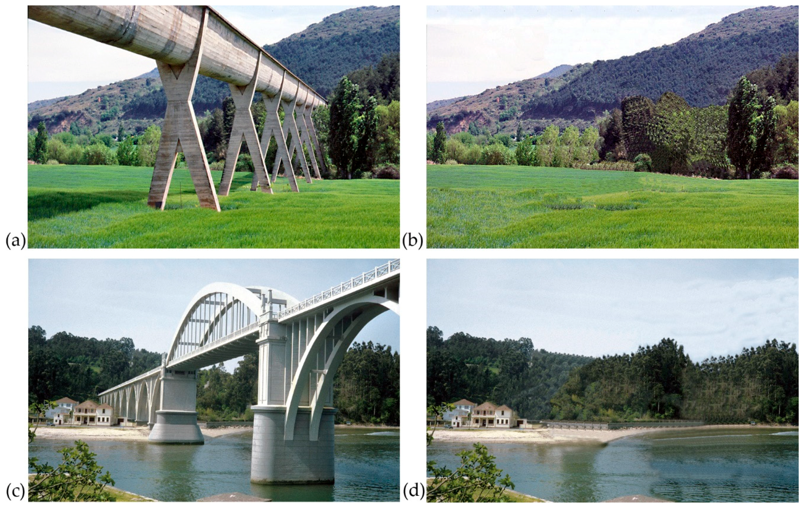
Industrial archaeology is helping to reverse the latter trend by adopting a few examples of works designed and built by civil engineers. Nonetheless, due to the complexity surrounding the public works’ heritages, specific strategies must be defined to ensure it is satisfactorily characterised and its worth, based not only on age, aesthetics or authorship [6], is publicly acknowledged. In the absence of such strategies, particulars, such as the territorial scale normally involved in transport infrastructure, the generally public ownership of such works, their long service life and acutely functional dimension, will continue to be ignored [7]. The comparison of real and reworked photographs in Figure 1 attests to the importance of public works in building territorial identity.
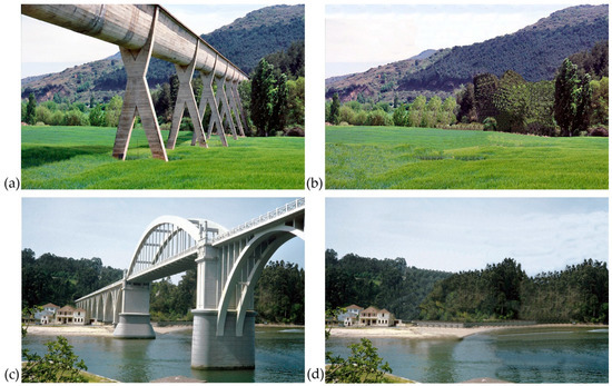
Figure 1.
Public works build the landscape: (a) Alloz Aqueduct, River Salado Valley, Navarre (E. Torroja, 1939); (b) same Scheme 1943; (c) Pedrido Bridge over Betanzos Estuary (E. Torroja, C. Villalba, 1943); (d) same scene without the bridge. Digital erasure of the works detracts from each place’s personality.
As a preliminary to protecting public works, action must consequently be conceived and implemented to heighten societal sensitivity to their heritage value and convey the historic, economic and social significance of civil engineers and their oeuvre.
To date, most institutions entrusted with safeguarding a country’s cultural heritage have limited their intervention to drawing up inventories of the most emblematic public works, covering long time spans and a wide spectrum of typologies. This is the case in Ireland [8], Japan [9] and the U.K. [10]. While promising, such initiatives have not managed to effectively connect with citizens potentially seeking information on historic public works. Rather, their dissemination has generally been restricted to engineers themselves, historians and construction and restoration professionals engaging in areas associated with the history, construction or restoration of these works.
Some well-consolidated programmes nonetheless promote the acknowledgement and appreciation of civil works with commemorative plaques and widely disseminated online databases. Examples may be found in the American Society of Civil Engineers’ Historic Civil Engineering Landmark Programme [11] and the Institution of Engineers Australia’s Engineering Heritage Recognition Programme [12].
The growing availability and use of, along with the interest in, new technologies have driven the development of quicker and more efficient data acquisition, management and visualisation, the so-called “democratisation of digital cartography” [13]. Such technologies now constitute a powerful tool for cultural heritage conservation, management and dissemination, as attested to by the many international congresses convened the world over (Conference on Cultural Heritage and New Technologies, Digital Media and its Applications in Cultural Heritage, International Conference on Virtual Cities and Territories).
Based on their experience, the authors believe new technologies favour access not only to descriptive but also to more interactive information that is associated with a number of heritage issues. They change users’ perceptions of and relationships with place and help them visualise the deep territorial significance of public works.
Applications dealing with public works per se are not available on the market. Most existing applications are geared towards tourism and, to a lesser extent, heritage conservation and management. Some mobile apps that are primarily intended for the tourist industry provide access to heritage data: IGeoPatrimonio [14] contains information on Portugal’s protected and non-protected natural and architectural heritage (architectural, urban, structural, parks, landscapes, place); Rewind Cities [15], a tourist app, narrates the history of Lisbon in augmented reality; App World Heritage [16] covers all UNESCO World Heritage Sites. In most cases, the technology, which is used for data storage (inventories, compilations, registry of heritage assets), is intended as support for disseminating/enhancing appreciation for an area’s heritage. The potential for interconnection with other databases or sources of information is promising. The acknowledgement and appreciation of the cultural heritage is a key to raising interest and favouring integrative conservation and action geared towards management policy.
In Spain, most conceptual and methodological research identifying, characterising and appraising the heritage of public works has essentially translated into inventories and catalogues [17,18,19,20,21,22], a few exhibitions [23], seminars [24] and symposia [25]. Recent years have begun to bring new and more comprehensive approaches; however, these stress the territorial significance of public works. Such initiatives are furthered and supported by a number of institutions that encourage research and dissemination of the public works’ heritages: Centre for Historic Studies on Public Works and Urban Planning (CEDEX-CEHOPU, 1983), Juanelo Turriano Foundation (1987), Demetrio Ribes Chair (2003) and Miguel Aguiló Foundation (FMA, 2009). The fourth, which is headquartered at the Technical University of Madrid’s School of Civil Engineering, focuses on the use of new technologies to further societal awareness of the country’s engineering heritage [26] with research and mobile apps, such as those described hereunder. Currently under development, the Spanish research project “Analysis and definition of territorial scale strategies to characterise, restore and heighten esteem for the public works heritage” [27] engages all these institutions in the definition and proposal of such strategies.
This article addresses the dissemination and furtherance of esteem for the public works’ heritages based on a number of research and development projects in which the authors have engaged. The common focus in all these studies is on the public works heritage and its association with place. The applied research involved aims towards retooling cost-free mobile applications built around the potential of geo-positioning technology and handset Global Positioning System (GPS) software to update communication and knowledge formats. Although the projects described are confined to continental Spain, the processes and findings are directly applicable anywhere in the world.
2. Materials and Methods
New technological tools are being used in a series of research initiatives that are seeking to connect more effectively with citizens that are potentially interested in civil engineering works. Such tools aim to explain and raise awareness of the heritage value of such elements in ways that are more appealing to today’s societies than the more traditional approach involving guidebooks, catalogues, lectures and exhibitions, which tend to be limited in scope and target very specific communities.
Such apps afford users access to high-quality, well-organised content. The geopositioning features of today’s mobile handsets provide the infrastructure for accessing the information required to identify truly useful and timely data and interpret public works in their territorial context. This, in conjunction with the quality of the display screen and simple and intuitive interfaces, makes smartphones ideal tools for disseminating explicative information about the landscape. Such devices also accommodate feedback, enabling users to enter useful information to enhance content or even add suggestions for amending procedures. By positioning users as partners, this feature raises interest in the app along with the content quality [28].
The methodology set out below was adopted to raise the appreciation for the public works’ heritages with the development of a series of applications, specifically, the heritage value of rural public works (VAPROP_Rutas), geolocation of the built heritage (GEOPACK), heritage public works on the River Duero (PHDuero), major works of engineering (GOING) and geolocation of Eduardo Torroja’s public works (underway). Although the methodology and objectives were shared, given the timing involved, progressive differences can be discerned, both in terms of the application programming technologies used (as described in Chapter 3) and the assessment of the values and results (set out in Chapter 4).
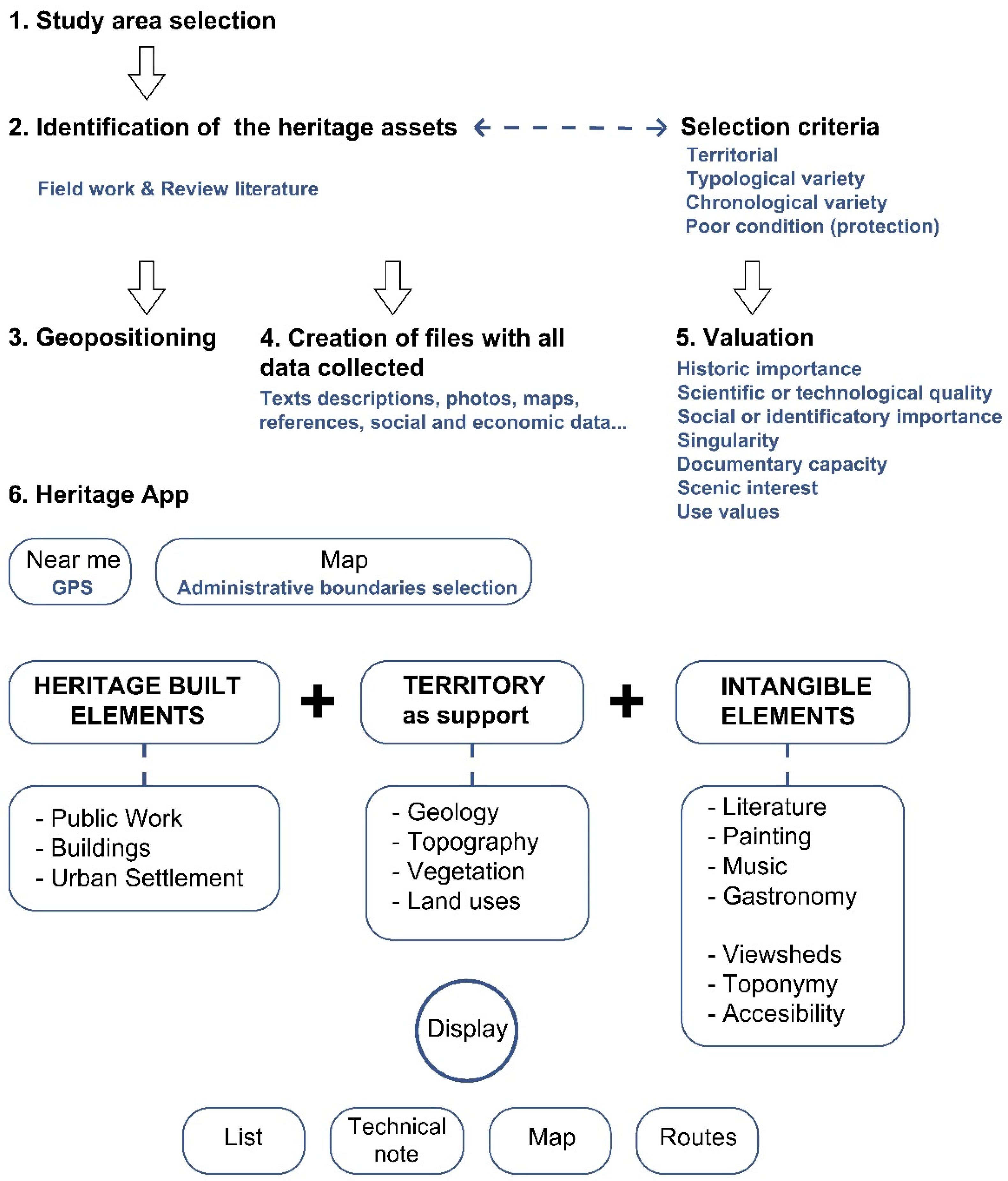
The methodology deployed is illustrated in Figure 2. The heritage elements to be spotlighted in a given area of study are identified in accordance with pre-defined selection criteria. After geopositioning the works, the respective datasheets were drawn up and used to categorise each work and analyse its values.
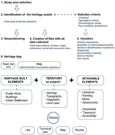
Figure 2.
Flowchart illustrating the methodology applied. GPS: Global Positioning System.
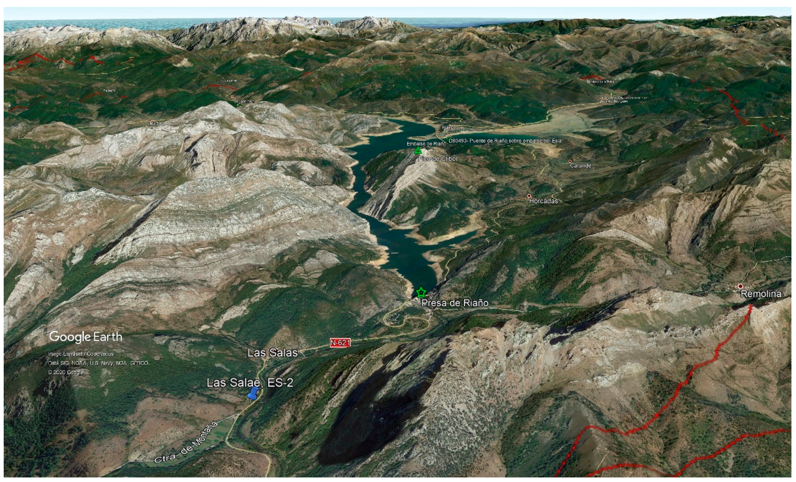
The first stage consisted of directly (fieldwork) or indirectly (documentary sources) identifying the elements of interest, which were then geopositioned (Figure 3) and characterised by descriptors, such as name, coordinates, town/region, type/subtype, date/author, physical description, literature and graphics (photographs, drawings, illustrations). Such standard fact sheets were then used to record the most prominent features and representative values of the works at issue.
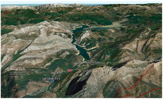
Figure 3.
Element geopositioning in the Duero River Basin near Riaño Dam in the Spanish province of León.
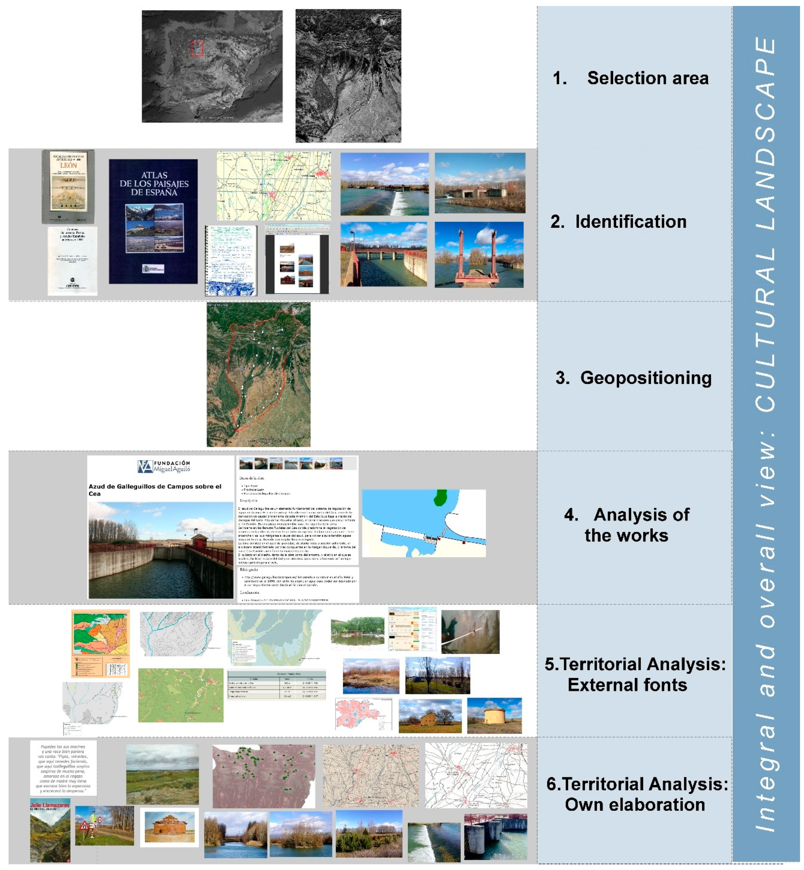
The territorial context was then analysed using external sources (maps, guides, aerial photographies) and the authors’ own data. The territorial elements studied with outside information were divided into physical and environmental variables on the one hand and socioeconomic variables on the other (Figure 3). Geological, geositing, topographic, flora and fauna, species distribution, land use, Corine Land Cover and environmental protection maps of the area, along with Sistema Automático de Información Hidrológica (Automatic Hydrological Information System, SAIH) data and landscape unit descriptions were deployed for the former. Analysis of the latter was drawn from data on demographics, population centres, local economics, sociocultural and entertainment options and folk architecture.
Author-compiled data include landscape intangibles (literature, painting, music, folklore, traditions and gastronomy) and information on the viewshed analysis, functionalities, place names, accessibility and landscape conversion. The starting point was a search in documentary sources and cultural catalogues to identify factors that determined the public works–society relationship. Such elements contribute to an understanding by the public at large and link the works to a place’s cultural fabric. Inter-relationships were subsequently established among the factors or elements identified. All the data and material compiled were then entered into the database that feeds the mobile app and the website where the information can be queried in an orderly manner.
Inter-relationships between the elements so defined were subsequently established to ultimately draw a comprehensive overview of the territorial and cultural landscape (Figure 4). In keeping with the European Landscape Convention, this holistic approach to the cultural landscape may serve as a tool for further protection, management and planning policies for the area studied and to raise awareness of and societal appreciation for civil works and their significance. The long-term goal is to further the integration of landscape-related issues into regional and town planning, as well as cultural, environmental, agricultural, social and economic policies, and any others that possibly impact such issues, directly or indirectly [29].
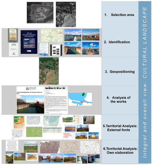
Figure 4.
Example of the characterisation methodology for a case study: Esla River Basin, Spain.
3. App Development and Use
Hosts of geopositioning-based applications have been developed since mobile handsets featuring this attribute were brought to the market. Along with websites such as Google Maps (mobiles), Layar, SyGic, GPS Navigation and LiveClubs, they enable users to access (primarily commercial) information in situ.
Cost-free applications for iOS and Android can be developed by using such features to make heritage- and landscape-related information available to users. The two major components on which their operation is based are the server or host and the handset or user.
The server was designed to install a hypertext preprocessor (PHP)-language-based web service, coded by Foundation Miguel Aguiló members, on mobile handsets upon user request, as well as query the database hosted by the server itself and generate and send the user a JavaScript Object Notation (JSON) object.
JSON, which is a subset of the European Computer Manufacturers Association -ECMA 262 standard published in December 1999, is a lightweight data exchange format that has been in extensive use for some time now, much as extensible markup language (XML) was in its day. It is compatible with a wide spectrum of languages, including Java, PHP, JavaScript, C++ and C#, to name a few.
The object, in the present case, contains the point coordinates, the name, the type, a brief description, classification, the storage address of the respective photograph and the uniform resource locator (URL) for the website carrying a more detailed description.
In the mobile part of the application, basic algebraic procedures are run in the iOS system, along with a presentation to and interaction with users, geopositioning, basic requests for information submitted to hosts, retrieval of the data requested and subsequent storage and processing for presentation to users.
The app is used as follows. When users select one of the regions covered by the project, their mobile handset connects to the QNAP Systems, Inc. (Taiwanese manufacturer providing virtual server service through MyCloudNAS) server, which sends back a list of geographic points and respective basic data. These are then organised by the program and the associated photographs are downloaded.
Users can access more detailed information on any point selected by tapping on a link to a built-in web browser or add the point to a list of elements to be visited.
When the first point is listed, the system connects to Google Maps and charts the optimal route from the user’s location to the first of the works and from there to the next. The software then adds the estimated visit time to the sum of all the travel times, helping users approximate the duration of their outing (Figure 5).
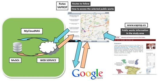
Figure 5.
VAPROP_Rutas procedural flowchart.
Routing decisions are likewise displayed on the screen, positioning the map in a way that enables users to readily identify the area where such decisions will need to be made.
As further applications are developed, new features are being included, along with techniques to improve both the quality and the user experience.
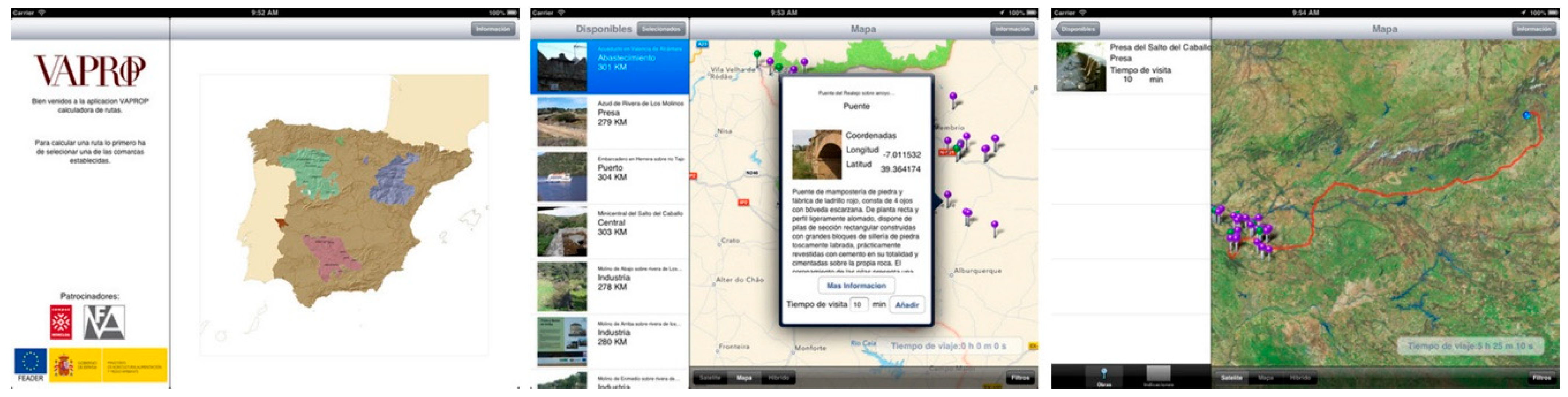
3.1. Valor del Patrimonio Rural de las Obras Públicas (VAPROP_Rutas) (Heritage Value of Rural Public Works)
VAPROP, a pilot project sponsored by Spain’s national rural network, essentially aimed to research and establish mechanisms for assessing the rural public works’ heritages, including its relationship with the surrounding landscape. VAPROP is an acronym adapted from the Spanish title of the project, “VAloración del Patrimono Rural de la Obra Pública”.
3.1.1. Data
In this case, given that the locations involved are primarily rural with uncertain telephone coverage, the points database form part of the application itself such that data can be accessed even without an internet connection.
3.1.2. Connections
A hypertext transfer protocol (HTTP) web browser built into the software calls up the detailed fact sheet for the element chosen by the user.
This MySQL architecture-supported database is embedded in the application as a list of works and their characteristics. It operates offline, with the major drawback being that it can only be modified by updating the app.
3.1.3. Display
The display features four options, represented by basic icons, for visualising information: map, availability, selection and indications, with the last three presented as swipeable tables.
Each element comes with a brief fact sheet showing the name, typology, coordinates, a photo, a brief description and buttons to access the detailed fact sheet, return to the previous page or add the element to the route-mapping list.
3.2. Geolocalización del Patrimonio Construido (GEOPACK) (Geolocation of the Built Heritage)
This application calls up data on heritage buildings and public works in Madrid, which are listed in the inventories kept by separate institutions. Its development entailed compatibilising the respective databases to furnish users with the location of the urban works selected without detracting from the operability of the route mapping tool.
3.2.1. Data
Inasmuch as all the works listed are found in urban locations and the data are retrieved from different databases, the starting data are reloaded each time the app is executed. One implication of this procedure is that data revisions are automatically available and users are consistently provided with the most up-to-date information. The trade-off is that the application cannot be used in places with spotty coverage.
3.2.2. Connections
This procedure, i.e., transmitting the start-up data to the device at the outset of each session, necessitates a lightweight protocol. In JSON, the one chosen here, a file is created in the server when the app is executed at the user’s request, thereby ensuring data currency since the file is created directly from the database.
To download the final fact sheet, users are directed to the respective organisation’s website.
MySQL architecture hosted on FMA’s server connects the handset to the database at the outset of each session to update any records that may have varied since the preceding session.
3.2.3. Display
The display consists of new icons representing the types of the works, together with the element number.
The information on a given element may be displayed in one of four modes: map, availability, selection (indicating the number of the point at issue and the type icon) and indications, with the last three presented as swipeable tables.
Each element comes with a brief fact sheet showing the name, typology, coordinates, a photo, a brief description and buttons to access the detailed fact sheet, return to the previous page or add the element to the route-mapping list.
3.3. Patrimonio Hidráulico del Duero (PHDuero) (River Duero Heritage Waterworks)
This section describes the formulation and implementation of a pilot project for using mobile platforms to further and raise awareness of the heritage value of waterworks in the River Duero basin.
3.3.1. Data
Given that both rural and urban data are involved in this app, a combination of the two preceding modus operandi were developed. Each time the application is executed, it checks the version of the data in place and compares them to the information in the server. If the server data are more current, it updates the information in its own database, and in the absence of an internet connection, it runs on the (not necessarily current) data in its own database.
3.3.2. Connections
For this procedure, a connection to the server must be established, where the JSON protocol notifies the mobile handset of the version of the data in place in each organisation. The device, in turn, compares that to the versions of the data stored in its memory. If the versions are the same, the application continues to run; otherwise, a copy of the latest version in JSON format is requested and the information housed on the handset is updated. If no connection can be established with the server, the user is notified accordingly and offered two options: to retry or to continue with the data on the smartphone that was downloaded the last time the app was executed.
Given that the SAIH (see Section 3.3.3) is an external service with no data exchange system in a machine language, such as JSON or XML, a parsing algorithm was developed to access the respective data. This software reads and interprets the website, locating the data requested on the grounds of text style and position and extracting them as a text string.
A PosgresSQL architecture hosted on the Duero River Water Management Board’s server connects the handset to the database at the outset of each session, deploying MySQL architecture to compare and, where necessary, synchronise the information.
3.3.3. Display
The display consists of new icons representing the types of the works, together with the element number.
Depending on the element, the app then proposes connections to the relational groups defined under headings such as visibility between mountain peaks, access to SAIH hydraulic data, folk architecture, culture, landscape and place names.
The four modes for visualising the information are map, availability, selection (indicating the number of the point at issue and the type icon) and indications, with the last three presented as swipeable tables.
Each element comes with a brief fact sheet showing name, typology, coordinates, a photo, a brief description and buttons to access the detailed fact sheet, return to the previous page or add the element to the route-mapping list.
3.4. Grandes Obras de Ingeniería (GOING) (Major Works of Engineering)
This section describes a pilot project for research on and dissemination of heritage public works in Spain.
3.4.1. Data
As this is a descriptive application, in the procedure adopted, the starting data are reloaded each time the app is run. One implication of the procedure is that data revisions are automatically available and users are consistently provided with the most up-to-date information. The trade-off is that the application cannot be used in places with spotty coverage.
3.4.2. Connections
This procedure, i.e., transmitting the start-up data to the device at the outset of each session, necessitates a lightweight protocol. In JSON, the one chosen here, a file is created in the server when the app is executed at the user’s request, thereby ensuring data currency since the file is created directly from the database.
The MySQL architecture hosted on the Chartered Institution of Civil Engineers’ (AICCP’s) server connects the handset to the database at the outset of each session to update any records that may have varied since the preceding session.
All the query procedures are based on a series of JSON-based Representational State Transfer (REST) services that facilitate data communication, which were chosen for their streamlined convertibility, legibility and lightweight.
The images, in turn, are processed to lighten their weight, adjusted to the quality best adapted to the handset and coded in parallel with the respective database to guarantee access from any of the features in the app.
3.4.3. Display
Two information display modes are provided: a map and a list specifying the scores awarded to the various points, with a type icon and representative photo in a swipeable format.
Each element is furnished with a fact sheet showing the name, type, material, access to photos, description and buttons to access expert assessments or return to the preceding page.
4. Results: The Mobile Apps
This section discusses the application development and results. The key features and their indicators are summarised in Table 1: territorial scope, areas analysed, types of works, urban/rural surrounds, selection criteria, assessment criteria, additional features and external databases, among others. Each app is described in greater detail under the respective subsection below.

Table 1.
Summary of characteristics of the five applications developed.
4.1. Valor del Patrimonio Rural de las Obras Públicas (VAPROP_Rutas) (Heritage Value of Rural Public Works)
The objective pursued by the research conducted was to assess the rural public works heritage, its association with place and the landscape and the mechanisms for its societal appreciation. It focused on heritage public works in the countryside (characterised by historic memory, territorial scatter, loss of distinguishing marks and neglect) and the development of mechanisms favouring the assimilation by local communities of the cultural, symbolic and compositional values of such works and their status as local assets. The project aimed to design and validate a line of work in pursuit of the aforementioned general objectives that would be applicable to any rural environment, irrespective of the number and size of the works involved or the respective communities’ idiosyncrasies.
The three Spanish counties with clearly distinct geographies and cultures chosen as the working domains for project development were Valencia de Alcántara in Extremadura, Campóo-Los Valles in Cantabria and Cameros Nuevo in La Rioja. This diversity of place, culture and organisational realities provided a sound basis for designing, testing and validating the methodology proposed.
The process entailed the dissemination, acquisition (encouraging local community participation in awareness-raising of the works) and knowledge (requisite to the assessment were identification, location and characterisation of the works and research on their social, historic and territorial context). The method used involved action, participation and research.
VAPROP_Rutas, an application that was intended as a means for reporting on the endeavour that led to cataloguing and describing the works selected, was the result of extensive fieldwork and a number of actions involving societal participation in the three areas studied. This tool for mobile handsets, which was a new approach to disseminating and interpreting the rural public works heritage, furnishes users with information on the location of the elements studied and the materials deriving from their study in the form of fact sheets. It also provided them with a tool to calculate the best route for accessing the work of their interest or plan a series of destinations and calculate the total time needed, including visit durations [30].
The criteria for assessing public works’ heritages that were applied were initially put forward by Fernández Ordóñez [31] and based on Riegl‘s traditional classification [1]; they included the five categories of values set out below, which were used to analyse historic bridges and their possible rehabilitation, and more generally, the public works’ heritages:
- Scientific value, which is judged in terms of a work’s authenticity. The scientific value of a structure is deemed equivalent to its archaeological value: the greater a monument’s authenticity and the lesser its manipulation, the greater its scientific value. Such value decisively conditions freedom of use. Relocating a work, for instance, is incompatible with the conservation of its scientific value.
- Historic value must not be mistaken for what has been termed scientific or archaeological value. A structure that has been highly altered and consequently holds scant scientific value may have substantial historic value. Many structures, while not authentic, carry enormous historic value.
- Symbolic value, which stems from the sentiment and esteem generated by a work in a given society. This is a significant category, for it is charged with emotion. After the original purpose vanishes, symbolic value is often all that is essentially left. A monument or landscape that is essential to one group of people may mean nothing to another. Symbolic value need not be associated with monumentality, however.
- Aesthetic value may often be the sole reason for deeming a historic public work worthy of conservation. It highlights its beauty, which, although on occasion is held in scant regard in civil engineering, plays a very significant role in its heritage status when viewed from an architectural perspective. Aesthetic appreciation is useful for categorising value.
- Utility value, which is understood as the present use of a historic public work, even where such use differs from the original purpose.
Public heritage status is not bestowed spontaneously on civil engineering works located in the countryside. Their nearly exclusive association with their practical purpose explains the lack of societal acknowledgement of their aesthetic value, historical significance or landscape dimension. In addition, their territorial scatter favours the deterioration of their materials and erasure from the community’s collective memory [32].
Societal participation and educational apps are imperative in such cases to incentivise the subconscious assumption by the community of the intangible values of public works and recover the territorial identity associated with the presence of such elements [33].
Such singular features of rural heritage public works, in particular, their geographic scatter, while inducing interpretational complexity may at the same time afford an opportunity to develop new avenues for innovative and suggestive interpretations, some of which are associated with mobile, internet-connected devices and applications, such as augmented reality. New technologies inform different ways to turn heritage to advantage, a pursuit closely related to the interpretation of the landscape and its relationship to public works (Figure 6).
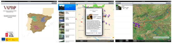
Figure 6.
VAPROP_Rural display screens.
4.2. Geolocalización del Patrimonio Construido (GEOPACK) (Geolocation of the Built Heritage)
This joint project aimed to disseminate heritage data via an app for mobile phones and tablets to help users identify and better understand heritage elements in situ. Jointly developed by two organisations, namely, the Miguel Aguiló Foundation [34] and the Documentation and Conservation of Buildings, Sites and Neighbourhoods of the Modern Movement (DOCOMOMO) Ibérico Foundation [35], the app provides iOS and Android platform users with the data on heritage buildings and public works in Madrid that are extant in their respective inventories. The information available includes the location of the urban works catalogued, which entailed compatibilising the respective databases without detracting from the operability of the route mapping tool.
The tool enables users to indistinctly access both databases, in which the heritage elements recognised and inventoried by their respective specialists are geopositioned, and helps to chart routes to visit such works, with information on opening hours and travel recommendations. It also advises users of the proximity of works, independent of whether they listed them as sites of interest (Figure 7).
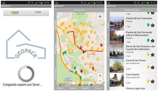
Figure 7.
GEOPACK display screens for iOS and Android.
GEOPACK was developed by the Miguel Aguiló Foundation as a tool for disseminating information on the built heritage inventoried by the foundation itself and its partners in the endeavour. It also aspires to be an inter-researcher communication channel for sharing quality information. Although presently confined to the Madrid region and the provinces of Málaga and Santander, the app aspires to national scope and expansion to involve more researchers by including a large number of geolocatable heritage elements in a user-friendly database.
Given the vast quantity and disparity of the origin of the data involved, the tool acts as a portal for all the information, with a brief list of geopositioned points and their respective evaluations. It also features route-charting and proximity alerts and enables users to obtain further information on the heritage element at issue from the project partners’ respective websites. That approach facilitates instantaneous, straightforward and independent content correction and updates from each organisation’s website.
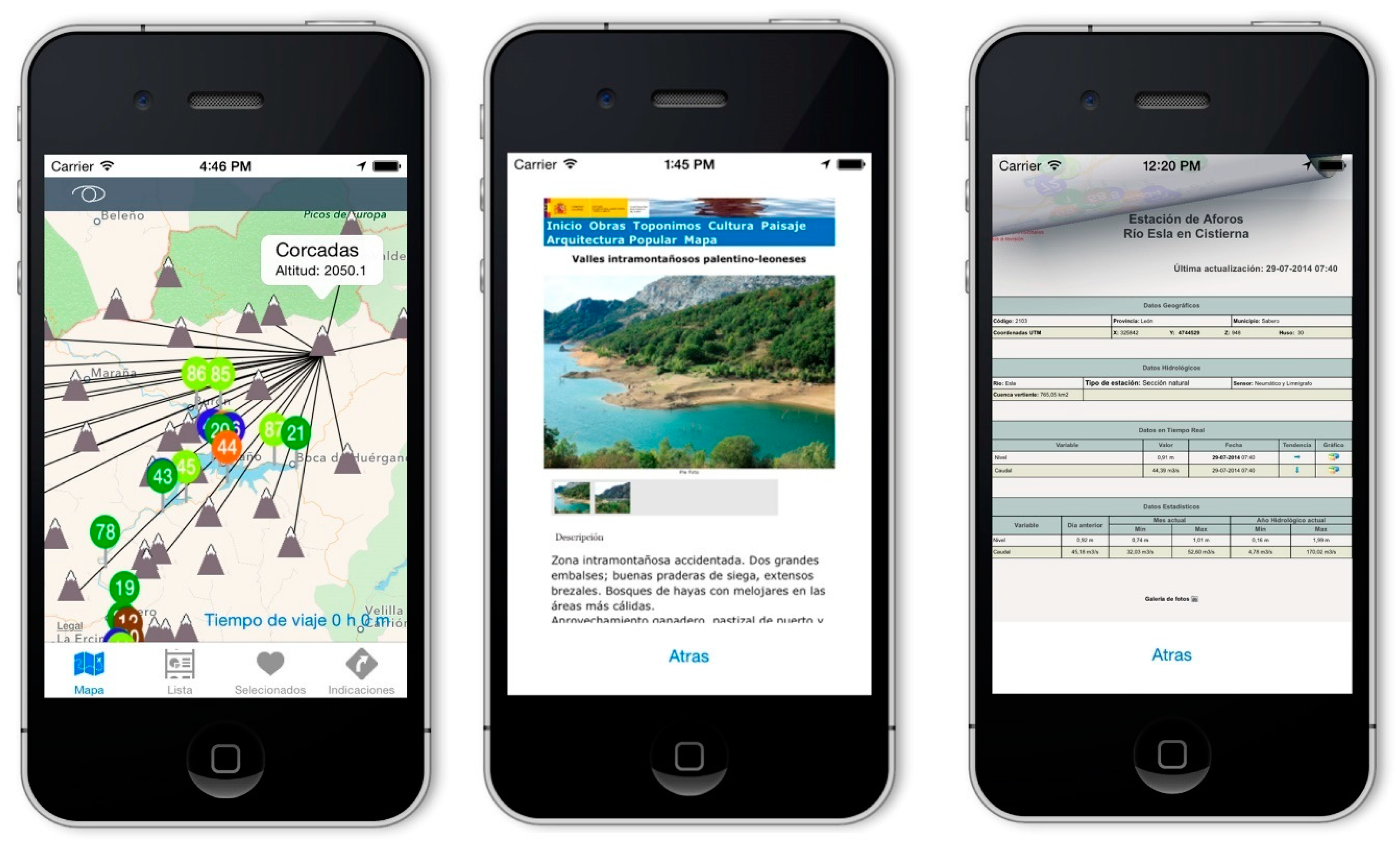
4.3. Patrimonio Hidráulico del Duero (PHDuero) (River Duero Heritage Waterworks)
This application groups the heritage waterworks on the River Duero in northern Spain (in the first version, only the ones in the Esla River Basin), along with information on singular points and many scores of photographs. The project aimed to characterise the area’s cultural landscape. It furnishes users with data on the location of the heritage elements in the Esla Basin, which are also grouped under headings, such as folk architecture, culture, place names, visibility and landscape unit. The app includes a route-charting tool to plan trips and features real-time connections to gauging stations to query the SAIH about hydraulic data (flow and level).
The waterworks heritage on the River Duero, which is outstanding for its landscape and cultural content, includes a broad spectrum of assets that must be conserved, both for their intrinsic value and the benefits deriving from their physical use and tourist or more general appeal in the context of sustainable development (Figure 8).

Figure 8.
Display with information on nearby mountain peaks, landscape unit and hydrological data retrieved from the Water Management Board’s website.
This study stressed the relationships between the elements that comprise a given territorial space. It includes numerical membership tables with n:n correlation for grouping elements and visibilities.
The information is hosted on the funding institution’s database server. The database feeds the web server that uses the information to generate both the website and the JSON-based REST service supporting the applications.
The database contains a series of tables that separate the information by type and characteristics, which is the most efficient procedure for streamlined content updating and presentation (Table 2).
Table 2.
Interdatabase element relationships allowed in the PHDuero database app.
This application won the 2015 edition of the Hispania Nostra Award for Good Cultural and Natural Heritage Practice [36,37].
4.4. Grandes Obras de Ingeniería (GOING) (Major Works of Engineering)
In addition to geolocating inventoried public works and enhancing their heritage value, the interpretative tool developed under this research project highlights their social purpose and contribution to territorial and socioeconomic development. It analyses their historical-cultural dimension while featuring functionalities, such as route-charting and networking with proposals for innovative cultural travel that are characterised by a deeper understanding of the landscape and the territorial value of public works.
The first phase of the project consisted of the selection and assessment of 130 culturally significant heritage elements and the creation of a web portal as a server for the app, which was hosted on the national AICCP website. In the second stage, presently underway, the various chapters of the AICCP are participating in the selection and inclusion of new landmarks in the programme, in keeping with the criteria set out below and the timeframe established [38].
The criteria that are applied to ensure an inclusive and sufficiently representative sample of works are listed below:
- The typology must be sufficiently varied to ensure the inclusion of both nodal works, in particular bridges, dams, lighthouses, ports and singular buildings (stations, market halls, towers), geographically extensive infrastructures and endeavours, such as canals, railways, roads, carriageways and highways, tunnels, urban planning (city enlargement or inner-city reform), water supply and drainage systems and underground networks.
- The locational variety is ensured by including significant public works from every region.
- The programme is also intended to span an extensive time frame, from the Roman era up to and, unlike the American Society of Civil Engineers’ programme, including the twenty-first century.
In addition to the above criteria and an asset’s constructional significance, given the advantages deriving from its accessibility and potential tourist interest, those features are also studied. A further consideration is the proximity of attractive places, such as natural parks or tourist resorts, to the extent that where public works can be repurposed for recreational use, their location in accessible or attractive surrounds constitutes an obvious opportunity.
The methodology previously deployed was also followed in this latest application, with the unprecedented inclusion of research on the criteria used to select works as programme targets. The aforementioned selection and assessment criteria were drawn primarily from manuals and essays on cultural heritage [39,40,41,42]. In addition, some ideas specifically referring to public works were retrieved from the Miguel Aguiló Foundation VAPROP programme, Rodriguez’s classification [43] for historic roads, and most prominently, the axiology proposed by José Antonio Fernández Ordóñez to the Council of Europe in the 1980s and used in VAPROP_Rutas [31].
The proposals put forward by Spain’s Cultural Heritage Institute (Spanish initials, IPCE) in the national industrial and cultural landscape plans [4,5] are also taken into consideration to assess the assets. Although they constitute a mere initial outline lacking any in-depth analysis, these proposals are of interest because they cover criteria that can be applied not only to nodal public works but also to regional scale infrastructures.
The evaluation and assessment criteria used in consolidated initiatives, such as the American Society of Civil Engineers’ (ASCE) Historic Civil Engineering Landmark Program [11] and the Institution Engineers Australia’s Engineering Heritage Recognition Program [12] are also taken into consideration.
The GOING project ultimately defines the following six assessment criteria for selecting the works to be included in its programme (Table 3):
Table 3.
Summary table of assessment criteria applied.
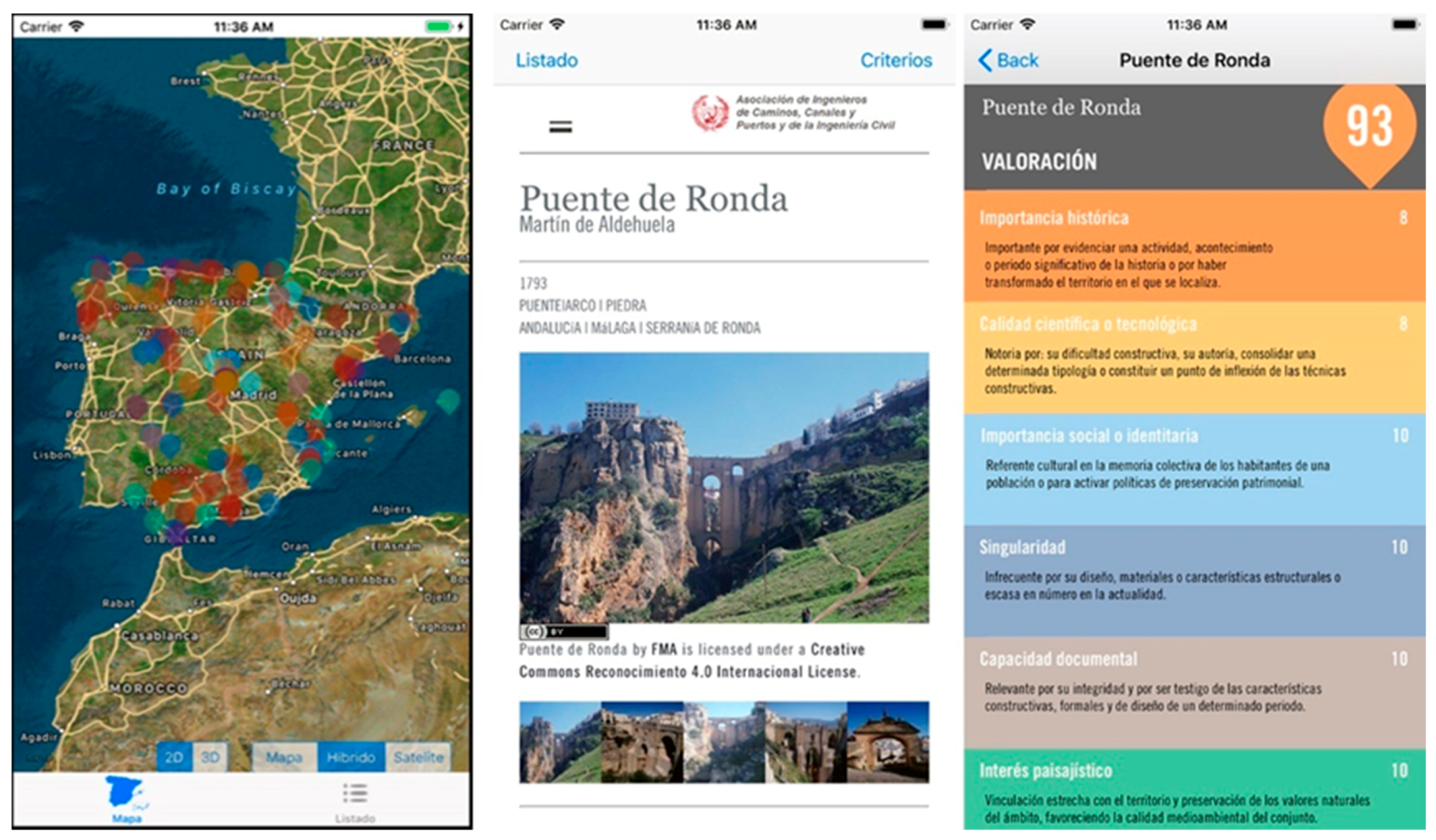
- Historic importance—a public work may be significant for attesting to a prominent historical activity, event or period or having transformed the region where it stands.
- Scientific or technological quality—the work is known for its constructional complexity, authorship, consolidating a given type of works or constituting a turning point in construction techniques.
- Social or identificatory significance (likened to the symbolic value described by Fernández Ordóñez [31])—provides a cultural benchmark in the collective memory of a given place or for its ability to drive heritage conservation policies.
- Singularity—its infrequent typology in terms of design, materials or structural or constructive characteristics or is one of a very few remaining from the era when it was built or is scantly present today.
- Documentary capacity (likened to the scientific value described by Fernández Ordóñez)—a credible and true source of information about the features characterising a given period, including construction techniques, strength, materials, form and design.
- Scenic interest—the work’s capacity and its subsequent interventions to blend with its location and favour a harmonious whole with its surrounds [44].
The assets nominated to form part of the programme are assessed by the aforementioned advisory committee and the researchers with the institutions involved in the project implementation. They are scored on a scale of 1 to 10 under each criterion. The mean is subsequently converted to a score on a scale of 0 of 100.
The works are classified by typology as bridges, dams, ports/lighthouses/coasts, water supply/irrigation (aqueducts, canals), linear infrastructures (railways, roads, carriageways, highways and tunnels), structures/towers/roofs and land/landscape/planning. Push pins that are colour-coded by group indicate the geolocation of each work on a map, while a general list sorted by overall score can also be displayed by tapping the “list” icon. These pushpins are semi-transparent for readier visualisation when they overlap.
The information may be displayed in map mode (where the options are hybrid, satellite, 2D or 3D) or from the list, where each work is shown with its overall score in its respective pushpin. In both cases, the screen displays the fact sheet on the element selected (Figure 9).

Figure 9.
Information display modes: hybrid map, Ronda Bridge fact sheet and the respective assessment criteria.
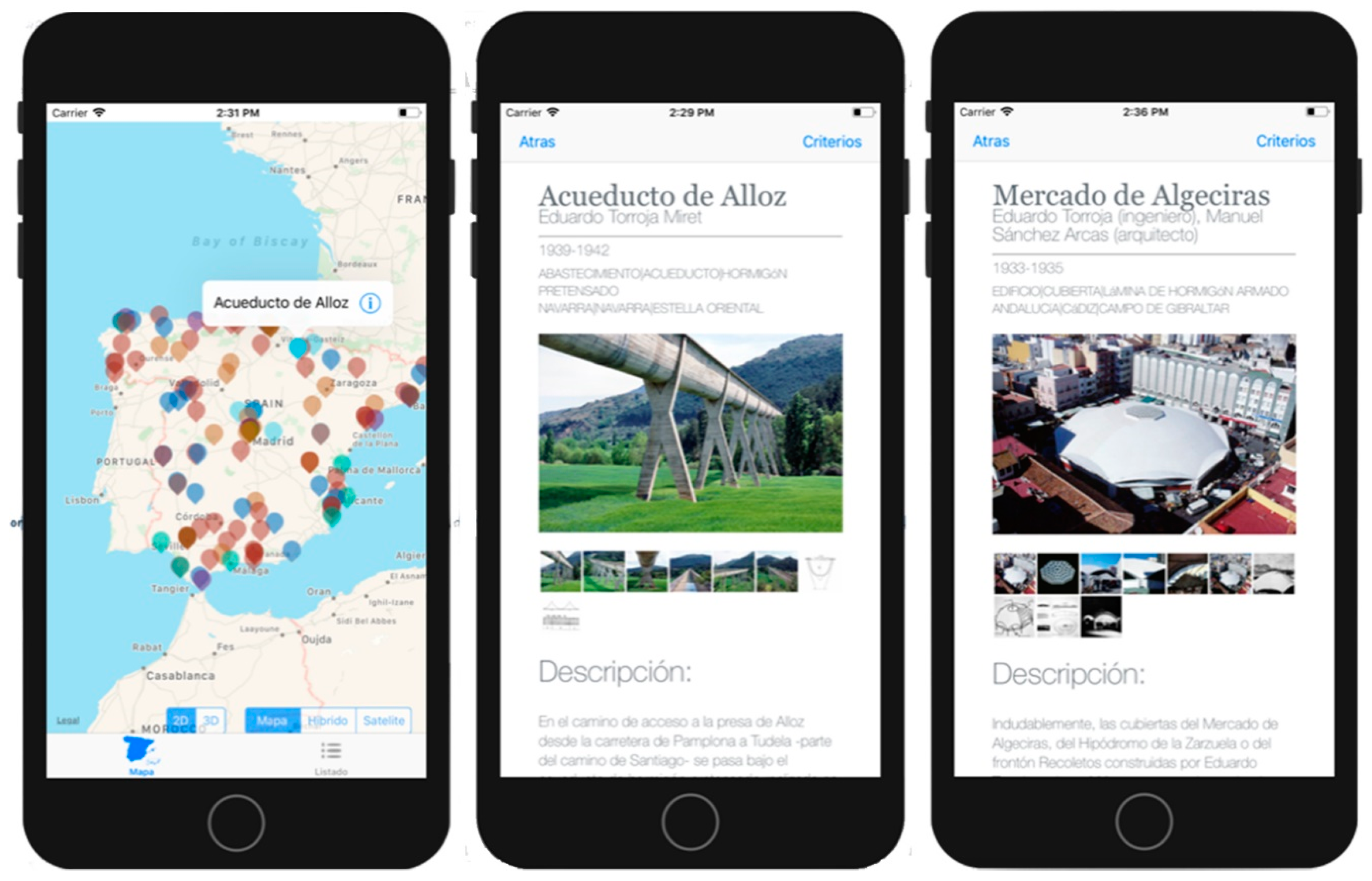
4.5. Geolocation of Eduardo Torroja’s Works (Underway)
As most of Torroja’s works have been studied in depth, the literature on the subject is both extensive and exhaustive. This application aims to compile all the information stored in a number of scattered institutional databases (Instituto de la Construcción Eduardo Torroja-CSIC, CEDEX-CEHOPU, Fundación Eduardo Torroja and its museum, Fundación DOCOMOMO Ibérico, FMA) into a single resource. The application will link all the digital documents stored in different types of files (text, reports, photos, drawings, scale models) by the aforementioned organisations and update the information with recent photographs of the works. Users will be able to select works for visits, obtain directions to access the works and calculate travel and visiting times.
This pilot project is intended as a platform for in-depth research into Torroja’s public works and is geared towards the landscapes and the identification, geolocation, assessment and recovery of Spain’s territorial scale civil engineering heritage. This will give rise to a second line of research that aims to contextualise the advent of reinforced and prestressed concrete.
Regarding places hosting several works, users may choose the “place” option, which opens up a window to analyse a given landscape and compare the works located there. The evolution of Torroja’s oeuvre and its relationship with later nearby works is another promising area to be discovered (Figure 10) [45].

Figure 10.
Screenshots of the application, Alloz Aqueduct geolocation and its fact sheet and the Algeciras market hall fact sheet.
5. Discussion
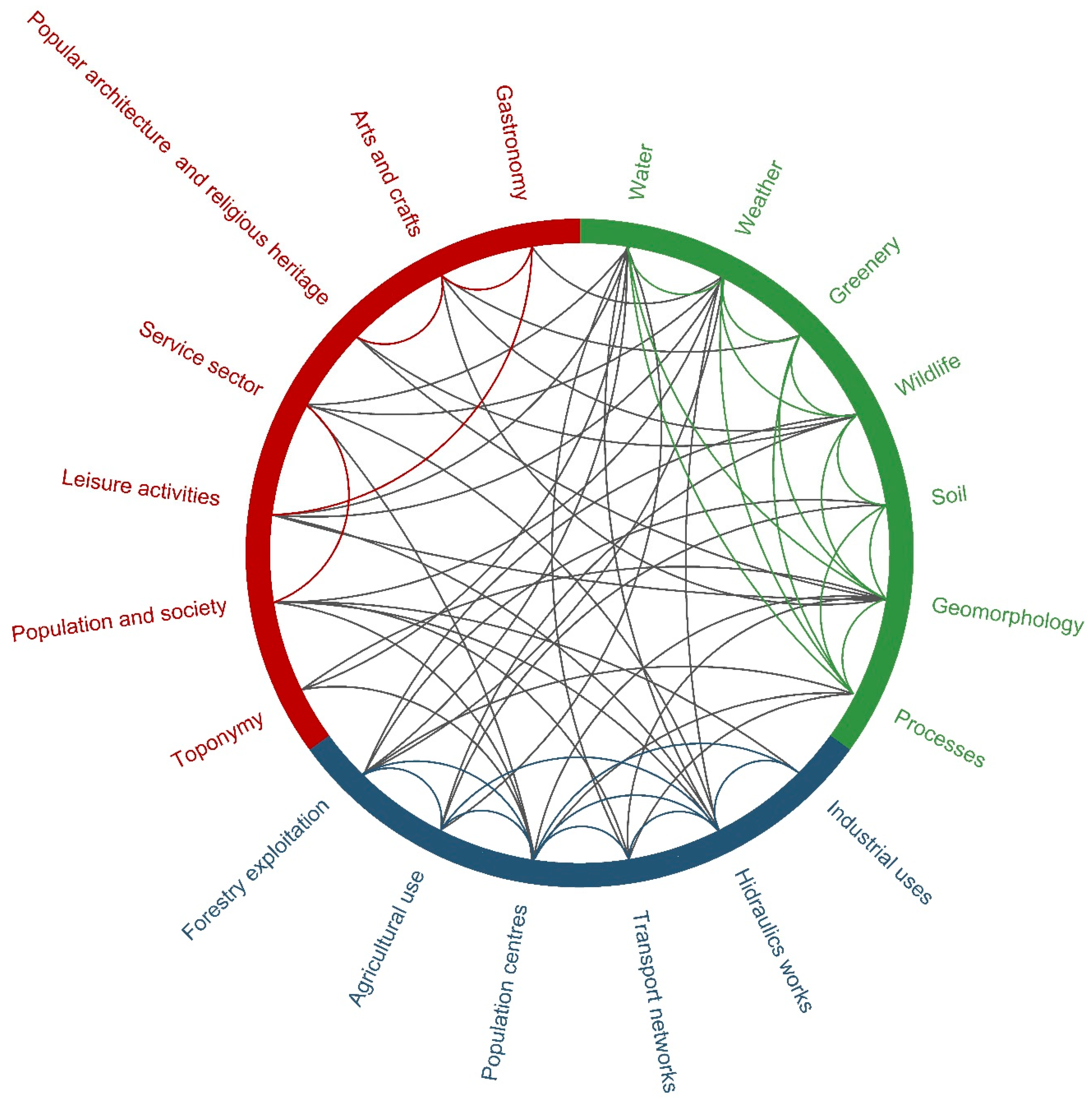
Civil engineering builds territorial context; its activity is essentially local-place- and landscape-related. A perspective that emphasizes the landscape is ideal for understanding public works in their physical surroundings and for assessing the sociocultural meaning and importance of the built environment. The cultural landscape is the result of the interaction between physical and environmental, territorial and cultural factors, as attested to in the analysis conducted to retool the aforementioned applications (Figure 11).

Figure 11.
Cultural landscape inter-relationships between land use (blue) and physical-environmental (green) and sociocultural (red) variables in the Esla River Basin as identified in the Patrimonio Hidráulico del Duero (River Duero waterworks heritage) project (source: formulated by the authors).
The scattered locations of rural public works and their close relationship to the landscape suggest the presence of innovative interpretative infrastructures. New internet-based reference and location facilities built into mobile devices broaden the opportunities for benefiting from the local heritage. Among others, these applications afford new approaches to cultural travel that is characterised by a deeper immersion in an area’s landscape and territorial values by furnishing information on what is to be seen and assistance in finding the right path with no need for the supplementary effort entailed in handling maps and guides. These features turn travelling into a wholly different and enormously educational experience [46,47].
A further immediate advantage of these tools is their geopositioning-based guidance for charting routes in advance or on the spot, with precise instructions on how to access the work or works selected from a list of those scattered across a given geography.
As opposed to traditional schemes for interpreting such assets (specialised books, erudite reports, lectures, guidebooks or catalogues targeting narrow and specific scientific and academic readerships), these new technologies inspire the use of familiar language to reach a wider audience instantaneously and interactively without forfeiting discourse rigour. As values of significance for today’s society, they will redound to more effective dissemination, bringing society at large into closer contact with its engineering heritage.
The drawbacks to the approach include its dependence on an Internet connection given that not all areas have the same quality of coverage, which may be insufficient in some valleys in Cantabria or along the southern border between Spain and Portugal (Valencia de Alcántara). The remedy consists of transmitting data in a style-free JSON format, which conveys information quickly and efficiently with the narrowest possible bandwidth to reduce the connection time and battery-charging requirements and ensure service in poor coverage areas. A more minor drawback is that a screen reflection in bright light can hinder the legibility where quality is less than optimal; this has been countered by designing a system of colours and contrasts in which the text is highlighted to enhance legibility in unfavourable conditions.
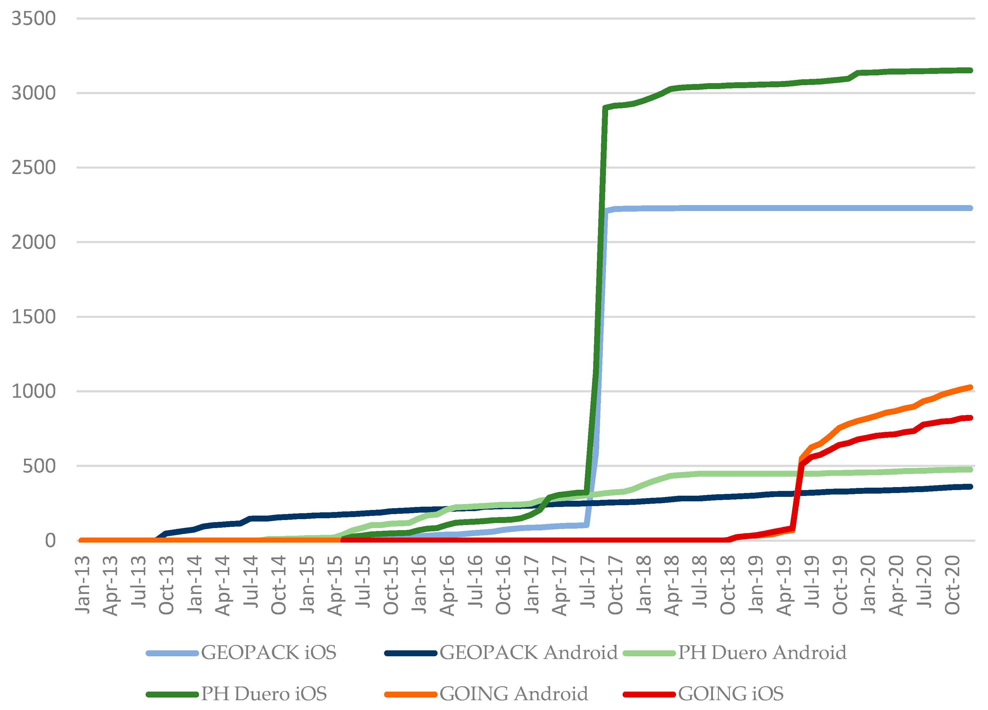
These applications are widely accepted by and interest users appreciative of this type of information and features (Table 4, Figure 12). A study of possible present and future uses for mobile devices supports the conclusion that projects such as those described here not only have a promising future but that their capacities more than cover the present and near-future needs. Data transfer speeds are suitable, provided that the communication protocols are correctly implemented. The geopositioning precision featured is sufficient for the specified use, whilst the data processing capacity is indisputably greater than required.
Table 4.
Number of app downloads and installations.
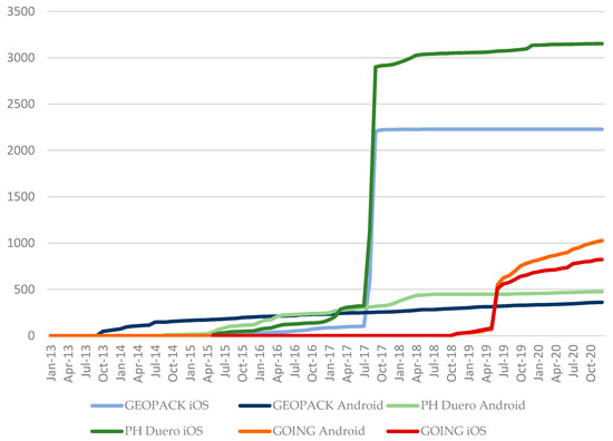
Figure 12.
Dissemination chart, the cumulative number of installations by application and the platform (source: formulated by the authors).
Heritage apps for mobile handsets have enormous potential for:
- establishing inter-relationships between the elements involved.
- developing tools for further protection, management and planning policies in the area studied.
- developing tools for disseminating the significance of and enhancing societal appreciation for civil works.
- meeting the long-term goal of furthering the inclusion of the landscape in all relevant policies, effectively mainstreaming the cultural landscape into the territorial planning tools in place.
- establishing a mechanism for public participation in cultural landscape conservation and the generation of new cultural landscapes.
- disseminating educational information on and raising target group awareness of how public works can generate cultural landscapes.
6. Conclusions
The author-developed applications designed to promote an appreciation for heritage public works, namely, the heritage value of rural public works (VAPROP_Rutas), geolocation of the built heritage (GEOPACK), heritage public works on the River Duero (PHDuero), major works of engineering (GOING) and geolocation of Eduardo Torroja’s public works (underway) are based on mobile and geopositioning technologies. They have proven to be both essential tools that favour access to vast amounts of orderly, geolocated information and a communication channel linking university researchers, institutions and the general public.
They afford access to quality information (texts, pictures of the past and present, maps, reports and mock-ups), converting what were originally large, bulky and heavy formats into lightweight files, which are all geared towards providing a fresh look at the heritage value of public works and their surrounds. Although the projects described are confined to Spain, the processes and findings are directly applicable anywhere in the world.
With these tools, territorial scale civil engineering heritage can be more fully identified, assessed, disseminated and recovered. Such initiatives also help to convey and heighten societal awareness of the historic, cultural, economic and social significance of engineers and their works.
A need is consequently felt for increasingly more sustained research and the implementation of latest-generation tools and new approaches to heritage information dissemination and management that are more appealing to today’s society.
Author Contributions
Drafted the article and acted as task coordinator, P.H.-L.; drew the figures and organised the references, B.C.-A.; programmed the assets and apps, Ó.d.C.-C.; wrote up the abstract and discussion, J.B.-L. All authors critically reviewed the manuscript for intellectual content and approved and agreed to the version prepared for publication. All authors contributed to the conception and design of the research conducted and the applications developed. All authors have read and agreed to the published version of the manuscript.
Funding
This research was conducted and the respective applications developed under the aegis of the FMA, with funding provided as follows: for VAPROP, by the Spanish Ministry of Agriculture, Food and the Environment; for GEOPACK, by FMA and DOCOMOMO Ibérico; for PHDuero, by the River Duero Water Management Board and the Spanish Ministry of Agriculture, Food and the Environment; for GOING, by the AICCP: 20171215-FMA.
Institutional Review Board Statement
Not applicable.
Informed Consent Statement
Informed consent was obtained from all subjects involved in the study.
Conflicts of Interest
The authors declare no conflict of interest.
References
- Riegl, A. El culto Moderno a los Monumentos: Caracteres y Origen; Visor: Madrid, Spain, 1987. [Google Scholar]
- Gonçalves, J.; Mateus, R.; Silvestre, J.D.; Roders, A.P. Going beyond Good Intentions for the Sustainable Conservation of Built Heritage: A Systematic Literature Review. Sustainability 2020, 12, 9649. [Google Scholar] [CrossRef]
- Martínez Vázquez de Parga, R. El patrimonio de las obras públicas. Rev. De Obras Públicas Col. De Ing. De Caminos Canales Y Puertos De Madr. 2003, 3, 79–82. [Google Scholar]
- Cruz, L. Plan nacional de Patrimonio Industrial: España; Instituto del Patrimonio Cultural de España, Ministerio de Educación, Cultura y Deporte: Madrid, Spain, 2016.
- Carrión, A.; Cruz, L. Plan Nacional de Paisaje Cultural: España; Instituto del Patrimonio Cultural de España, Ministerio de Educación, Cultura y Deporte: Madrid, Spain, 2015.
- Chrimes, M. Engineers and conservation: Two centuries and no progress? In Engineering History and Heritage; ICE: London, UK, 2016; Volume 169, pp. 165–180. [Google Scholar] [CrossRef]
- Ruiz-Fernández, R.; Rodríguez-Lázaro, F.J.; Coronado, J.M. Civil Engineering Heritage in Spain: Public Protection Strategies. In Engineering History and Heritage; ICE: Albacete, Spain, 2016; Volume 2, pp. 84–94. [Google Scholar] [CrossRef]
- Cox, R.; Gould, M.H. Civil Engineering Heritage; Thomas Telford Ltd.: London, UK, 1998. [Google Scholar]
- Isohata, H. Civil engineering heritage: Country profile—Japan. In Engineering History and Heritage; ICE: Tokyo, Japan, 2016; Volume 169, pp. 95–100. [Google Scholar] [CrossRef]
- Addis, B.; Miller, J. Civil engineering heritage: Country profile—England. Eng. Hist. Herit. 2017, 170, 80–86. [Google Scholar] [CrossRef]
- ASCE—American Society of Civil Engineers. Historic Civil Engineering Landmark Program. Available online: https://www.asce.org/landmarks/ (accessed on 20 May 2019).
- IEA—Institution Engineers Australia. Engineering Heritage Recognition Program. Available online: https://www.engineersaustralia.org.au/resource-centre/resource/australian-engineering-heritage-register (accessed on 20 May 2019).
- Corrreia Marques, L. Augmented Valuation of Cultural Heritage through Digital Representation Based upon Geographic Information Technologies. Ph.D. Thesis, Urban and Architectonic Management and Valuations, Escola Tècnica Superior d’Arquitectura de Barcelona, Universitat Politècnica de Catalunya, Barcelona, Spain, 2017. [Google Scholar]
- iGeo Patrimonio App. Available online: http://www.monumentos.gov.pt/site/app_pagesuser/SitePageContents.aspx?id=49fb54a7-4597-46ca-b6d1-78f824cdc7eb (accessed on 10 December 2020).
- Rewind Cities App. Available online: https://www.edc.pt/portfolio/rewind-cities/ (accessed on 20 December 2020).
- World Heritage App. Available online: https://www.appworldheritage.com/es/ (accessed on 10 December 2020).
- Fernández-Ordoñez, J.A. Catálogo de Puentes Anteriores a 1936; Colegio de Ingenieros de Caminos, Canales y Puertos: Madrid, Spain, 1984. [Google Scholar]
- Fernández-Ordóñez, J.A. Catálogo de Treinta Canales Españoles Anteriores a 1900; MOPU: Madrid, Spain, 1986. [Google Scholar]
- Fernández-Ordoñez, J.A. Catálogo de Noventa Presas y Azudes Españoles Anteriores a 1936; Colegio de Ingenieros de Caminos, Canales y Puertos: Madrid, Spain, 1988. [Google Scholar]
- De las Casas, A. Guía de Obras Públicas en Andalucía; Colegio de Ingenieros de Caminos, Canales y Puertos: Madrid, Spain, 2014. [Google Scholar]
- Sánchez Beitia, S. Catálogo de Faros con Valor Patrimonial en España; Instituto del Patrimonio Cultural de España: Madrid, Spain, 2017. [Google Scholar]
- Romero, D. El patrimonio documental de las obras públicas y las exposiciones: Cómo se enseña y se difunde. In Revista de Obras Públicas; Colegio de Ingenieros de Caminos, Canales y Puertos de Madrid: Madrid, Spain, 2014; Volume 3559, pp. 43–50. [Google Scholar]
- Hernández-Lamas, P.; Ruiz-Bedia, M.L. Patrimonio y Paisaje de la Ingeniería Civil. I Jornada de Trabajo; Universidad de Cantabria: Santander, Spain, 2014. [Google Scholar]
- CICCP; CEDEX; AIC. Proceedings of the I Foro Patrimonio Cultural de la Obra Pública, Madrid, Spain, 21–22 October 2019; Colegio de Ingenieros de Caminos, Canales y Puertos de Madrid: Madrid, Spain.
- Ruiz-Bedia, M.L.; Hernámdez-Lamas, P.; Castro, O. Difusión del paisaje y patrimonio a través de las nuevas tecnologías. In Proceedings of the REHABEND, Congreso Latinoamericano Sobre Patología de la Construcción, Tecnología de la Rehabilitación y Gestión del Patrimonio, Santander, Spain, 1–4 April 2014; pp. 2215–2221. [Google Scholar]
- Castro, O.; Hernández-Lamas, P.; Ramiro, M.J.; Hernández-Jiménez, V.; López-Rodríguez, A.; Berrocal, A.B. Las nuevas tecnologías en la difusión del paisaje. In Proceedings of the II Congreso de Ingeniería Civil y Territorio: Agua, Cultura y Sociedad, Galicia-Norte de Portugal, Colegio de Ingenieros de Caminos, Canales y Puertos de Galicia, Vigo, Spain, 20–21 May 2013; pp. 1–9. [Google Scholar]
- Análisis y Definición de Estrategias Para la Caracterización, Recuperación y Puesta en Valor del Patrimonio de las Obras Públicas: Una Aproximación Desde la Escala Territorial (PID2019-105877RA-I00); Proyectos I+D+i, 2020–2022; Ministerio de Ciencia, Innovación y Universidades: Madrid, Spain, Coordinador: Rita Ruiz, Universidad de Castilla La Mancha. (current research).
- Rubio, A.; Hernámdez-Lamas, P.; Ramiro, M.J. Waterworks Landscape, Case of study: Esla River Basin, Poster. In Proceedings of the CHeriScape Conference I: Landscape as Heritage in Policy, Ghent, Belgium, 1–2 June 2014; pp. 22–23. [Google Scholar]
- FMA—Fundación Miguel Aguiló. VAPROP_Rutas, Valoración del Patrimonio Rural de la Obra Pública; Ministerio de Medio Ambiente y Medio Rural y Marino: Madrid, Spain, 2012.
- Di Fazio, S.; Modica, G. Historic Rural Landscapes: Sustainable Planning Strategies and Action Criteria. The Italian Experience in the Global and European Context. Sustainability 2018, 10, 3834. [Google Scholar] [CrossRef] [Green Version]
- Fernández-Ordóñez, J.A. Obras Públicas y Monumentos; Revista de Obras Públicas del Colegio de Ingeniero de Caminos, Canales y Puertos: Madrid, Spain, 1995; pp. 7–13. [Google Scholar]
- Hernández-Lamas, P. GEOPACK. App para Geolocalización del Patrimonio Construido. In Cuaderno de Diseño de Obra Pública, 5; ADOP: Spain, 2013; p. 36. Available online: https://www.cercleinfraestructures.cat/wp-content/uploads/2013/10/Cuadernos_N5.pdf (accessed on 10 December 2020).
- Hernández-Jiménez, V.; Escribano, R.; Sotelo, J.A.; González, S.; Aguiló, M. Participatory Processes for Valuing Cultural Landscapes in Rural Areas; CEI Moncloa: Madrid, Spain, 2013. [Google Scholar]
- FMA—Fundación Miguel Aguiló. Available online: http://www.fundacionmiguelaguilo.org/en/Publicaciones/Aplicaciones.html (accessed on 3 December 2020).
- Fundación DOCOMOMO Ibérico. Available online: http://www.docomomoiberico.com/index.php?option=com_content&view=article&id=81&Itemid=206&lang=en (accessed on 2 December 2020).
- FMA—Fundación Miguel Aguiló. PHDuero—Patrimonio Hidráulico del Duero. Confederación Hidrográfica del Duero—Ministerio de Agricultura, Alimentación y Medio Ambiente. 2014. Available online: http://www.mirame.chduero.es/PHD/ (accessed on 10 December 2020).
- Castro, O.; Sarabia, A. El sentido de Catalogar; de los Estudios Históricos y los Inventarios a las Nuevas Aplicaciones; Revista de Obras Públicas del Colegio de Ingenieros de Caminos, Canales y Puertos: Madrid, Spain, 2014; pp. 7–78. [Google Scholar]
- Hernández-Lamas, P.; Ruiz-Fernández, R.; Cabau, B.G.O. ING Grandes Obras de INGeniería. Una app para la identificación, valoración y difusión del patrimonio de las obras públicas. In Proceedings of the VII Seminario del Aula G+I_PAI, ¿Cuál es el Futuro del Patrimonio Industrial? Madrid, Spain, 5–6 November 2020. [Google Scholar]
- González-Varas, I. Conservación de Bienes Culturales: Teoría, Historia, Principios y Normas; Ediciones Cátedra: Madrid, Spain, 2000. [Google Scholar]
- González-Varas, I. Las Ruinas de la Memoria: Ideas y Conceptos Para una (im)Posible Teoría del Patrimonio Cultural; Siglo XXI Editores: Ciudad de México, Mexico, 2014. [Google Scholar]
- Muñoz Viñas, S. Teoría Contemporánea de la Restauración; Síntesis: Madrid, Spain, 2003. [Google Scholar]
- Salerno, E. Identifying Value-Increasing Actions for Cultural Heritage Assets through Sensitivity Analysis of Multicriteria Evaluation Results. Sustainability 2020, 12, 9238. [Google Scholar] [CrossRef]
- Rodríguez-Lázaro, F.J.; Coronado, J.M.; Ruiz-Fernández, R.; Garcilaso de la Vega, J. Análisis y Valoración del Patrimonio de las Carreteras Españolas, 1748–1936; CEDEX-CEHOPU: Madrid, Spain, 2007; Volume 2. [Google Scholar]
- Hernández Lamas, P.; Ruiz Fernández, R. Proyecto piloto G•O•ING Grandes Obras de Ingeniería; Revista de Obras Públicas del Colegio de Ingenieros de Caminos, Canales y Puertos: Madrid, Spain, 2019; pp. 58–67. Available online: http://ropdigital.ciccp.es/pdf/publico/2019/2019_octubre_3613.pdf (accessed on 22 May 2020).
- Hernández-Lamas, P.; Cabau, B. Geography of Torroja’s works: An app for the geolocation and dissemination of his works. In Proceedings of the International Conferenceon Construction Research, Eduardo Torroja AEC, Instituto de Ciencias de la Construcción y Fundación Eduardo Torroja, Madrid, Spain, 21–23 November 2018; pp. 383–390. [Google Scholar]
- Bernabeu, J.; Berrocal, A.B.; Hernández, P.; López, A.; Hernández, V. La consideración patrimonial de las obras públicas. In Proceedings of the Criterios de Intervención en el Patrimonio Arquitectónico del Siglo XX, Ministerio de Educación y Cultura, Madrid, Spain, 14–16 June 2011; pp. 231–240. [Google Scholar]
- Berrocal, A.B.; Bernabéu, J.; López-Rodríguez, A.; Hernández-Jiménez, V.; Hernández-Lamas, P. Patrimonio rural disperso. In Proceedings of the CAH20thC—Conferencia Internacional de Criterios de Intervención en el Patrimonio Arquitectónico del Siglo XX, Madrid, Spain, 14–16 June 2011; pp. 1–6. [Google Scholar]


Publisher’s Note: MDPI stays neutral with regard to jurisdictional claims in published maps and institutional affiliations. |
© 2021 by the authors. Licensee MDPI, Basel, Switzerland. This article is an open access article distributed under the terms and conditions of the Creative Commons Attribution (CC BY) license (http://creativecommons.org/licenses/by/4.0/).