
Universal Mobility in Old Core Cities of India: People’s Perception


Abstract
1. Introduction
1.1. Research Components
1.2. Research Process
2. Literature
2.1. Universal Design Theory
2.2. Fundamental Understanding of Accessibility
2.3. Universal Mobility in Urban Areas
3. Survey and Results
3.1. Opinion of Design Fraternity in India
3.1.1. Observation and Analysis
3.1.2. Findings and Discussion
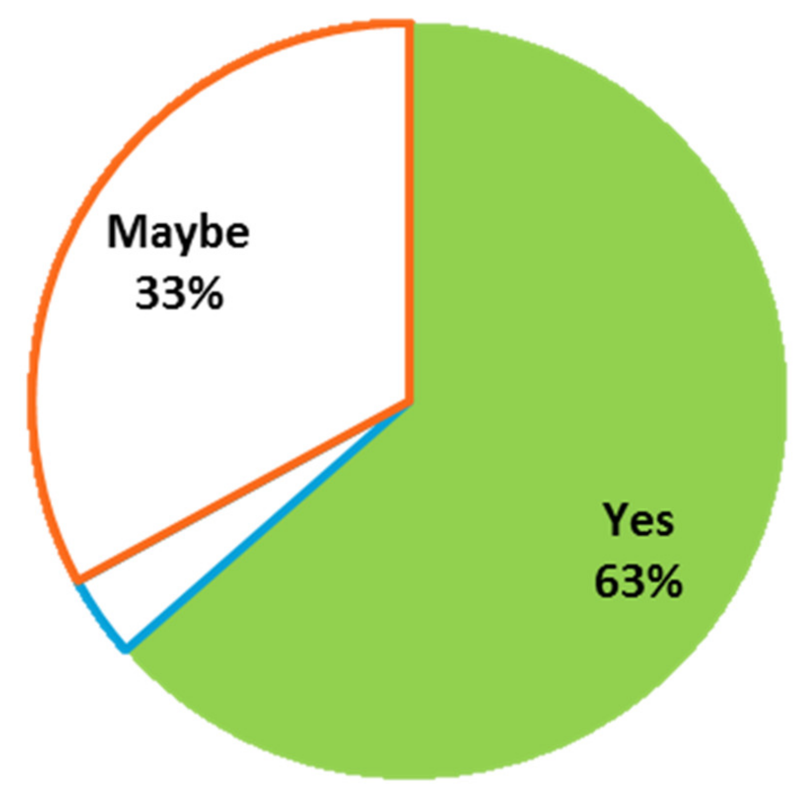
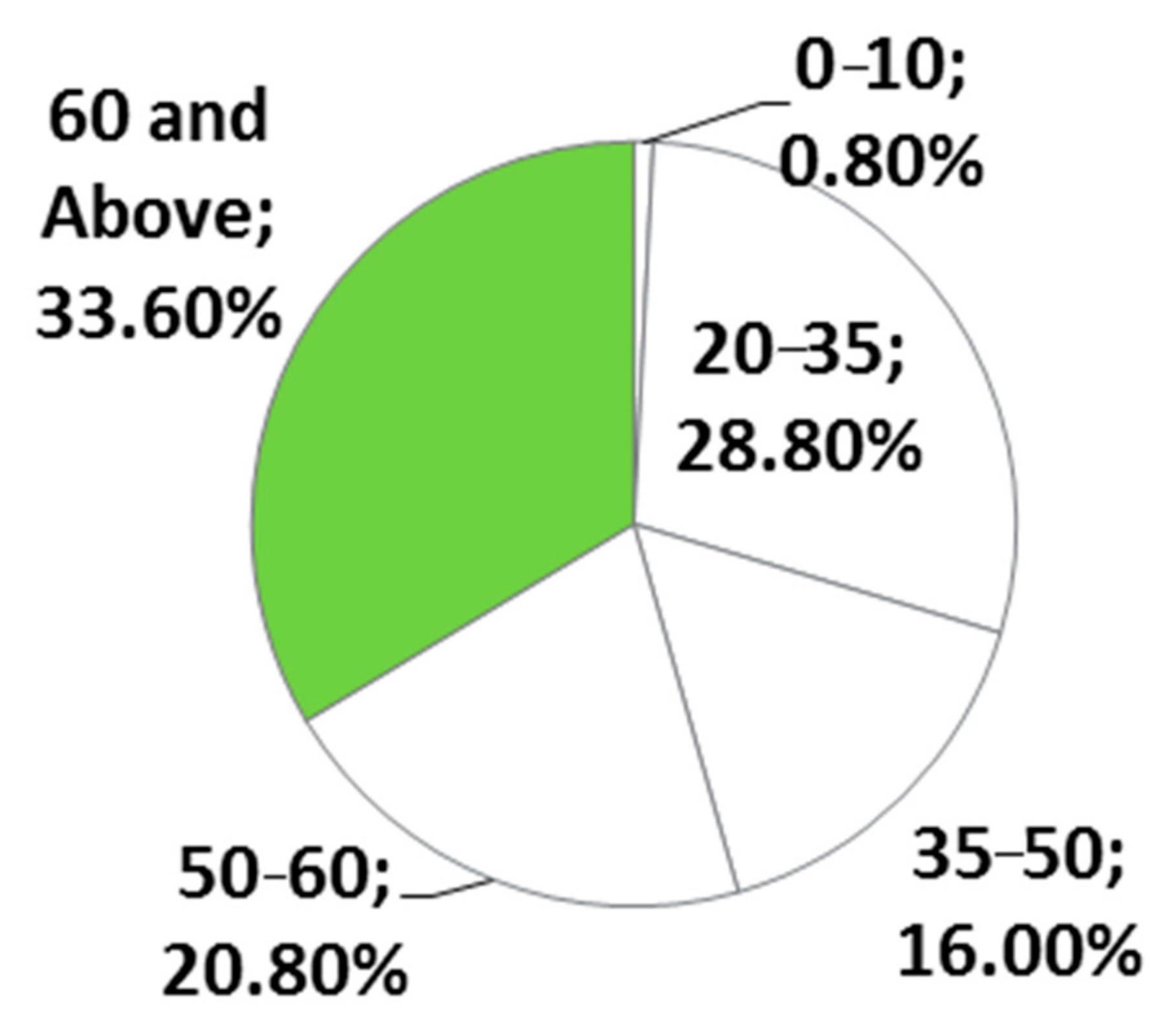
3.2. People’s Perception in an Old City Regarding Walkability and Mobility
3.2.1. Data Analysis
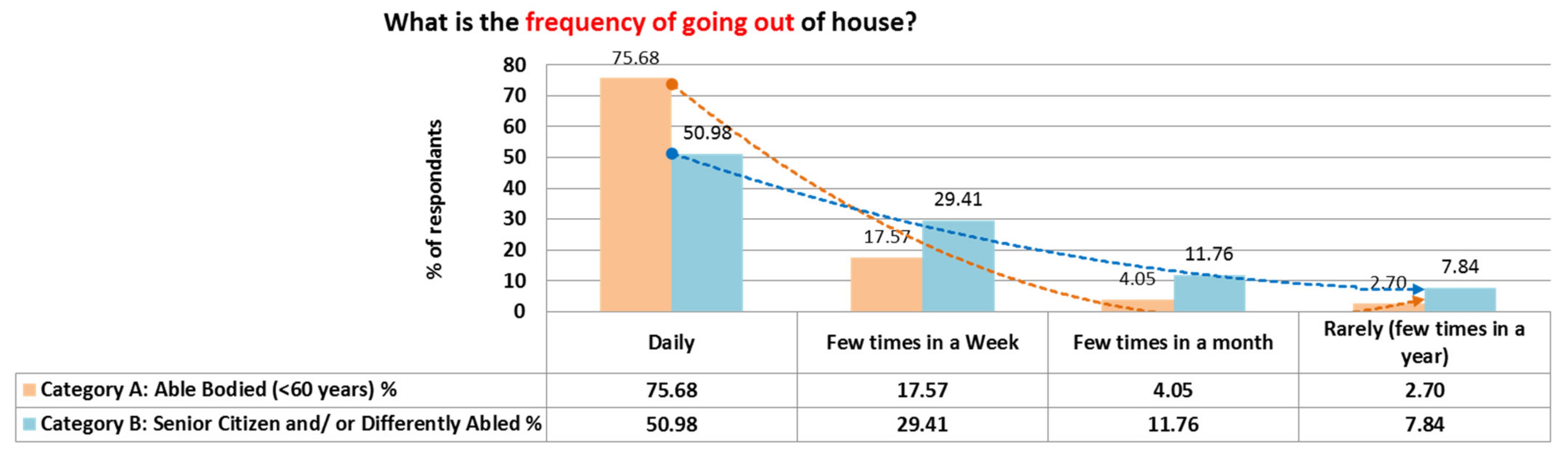
- Frequency and purpose of going out.
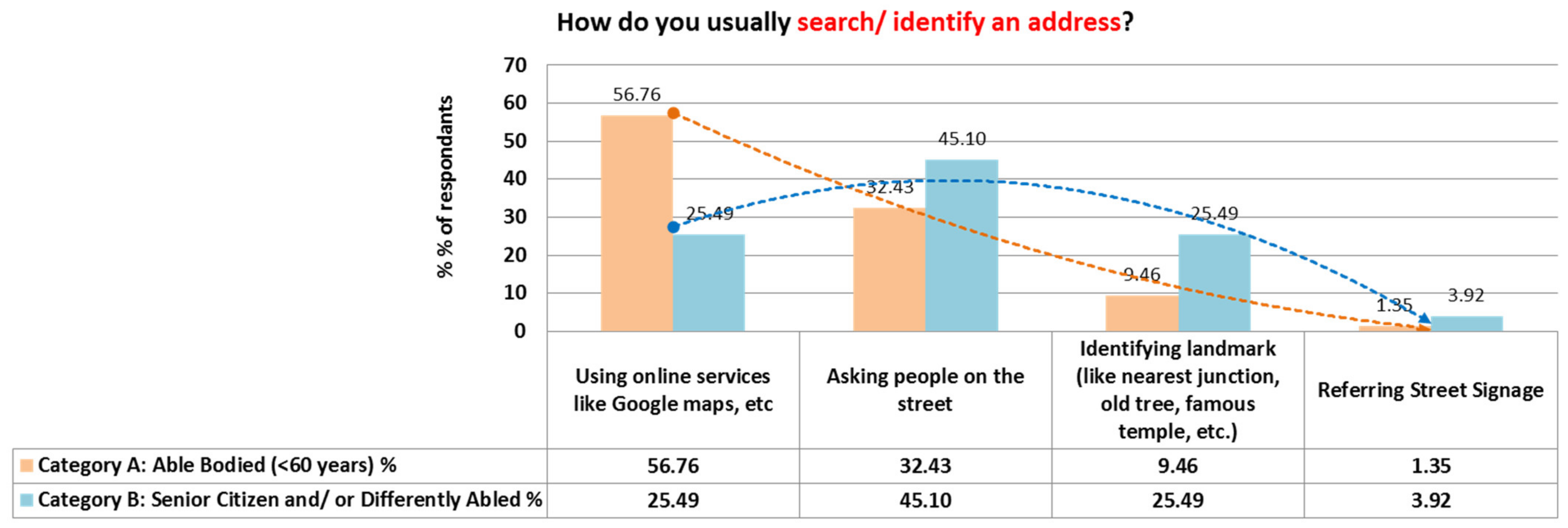
- Searching/identification of an address.
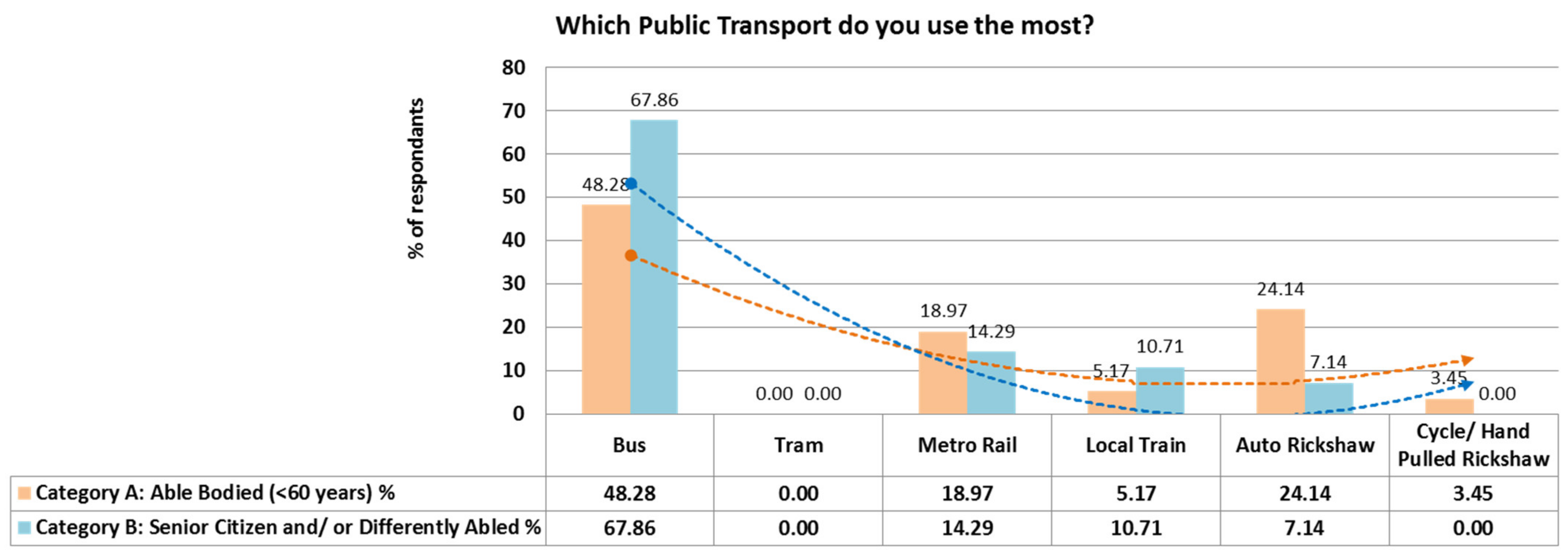
- Public Transportation.
- Walkability
- Awareness about National Schemes.
3.2.2. Findings and Discussion
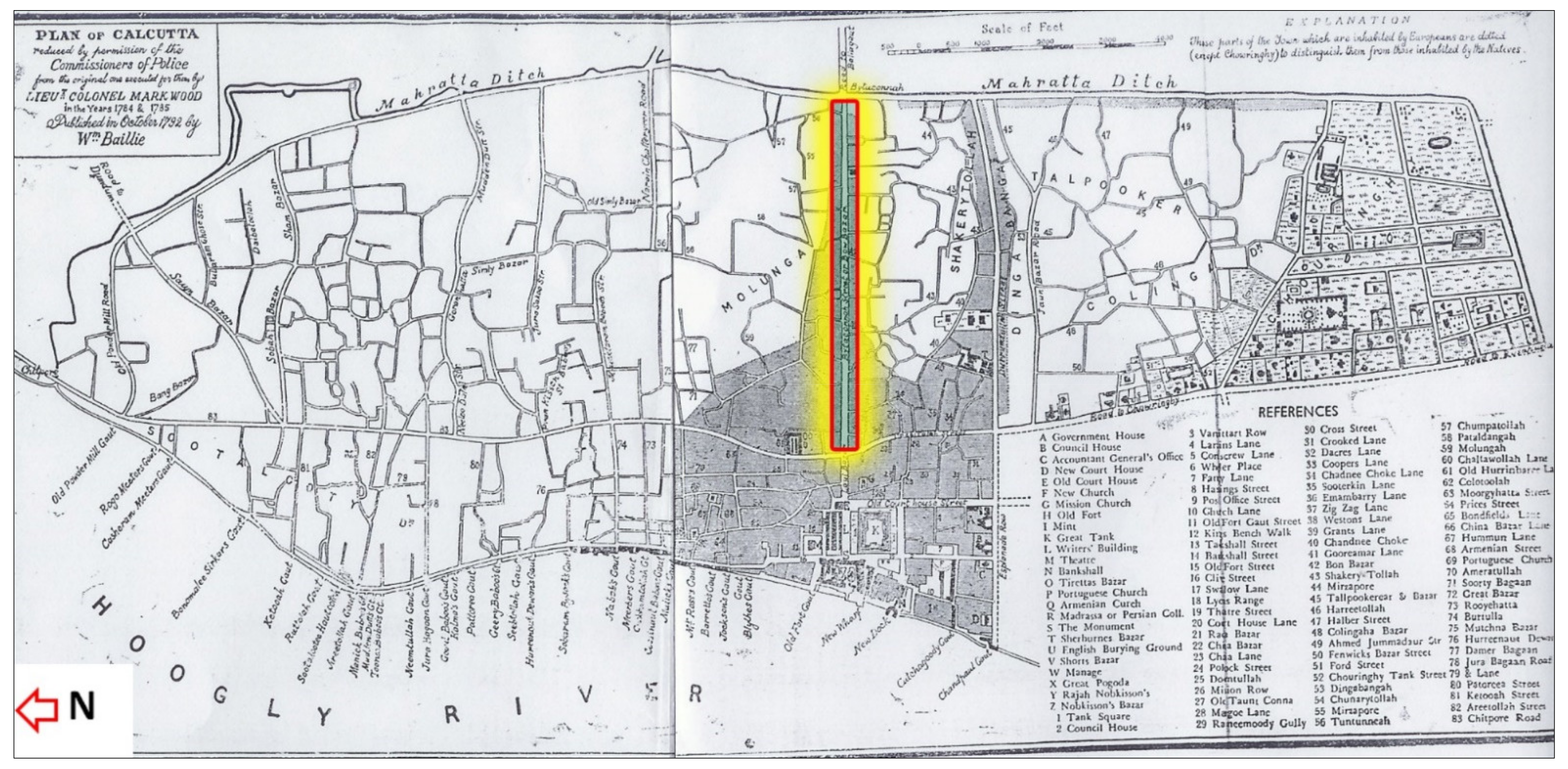
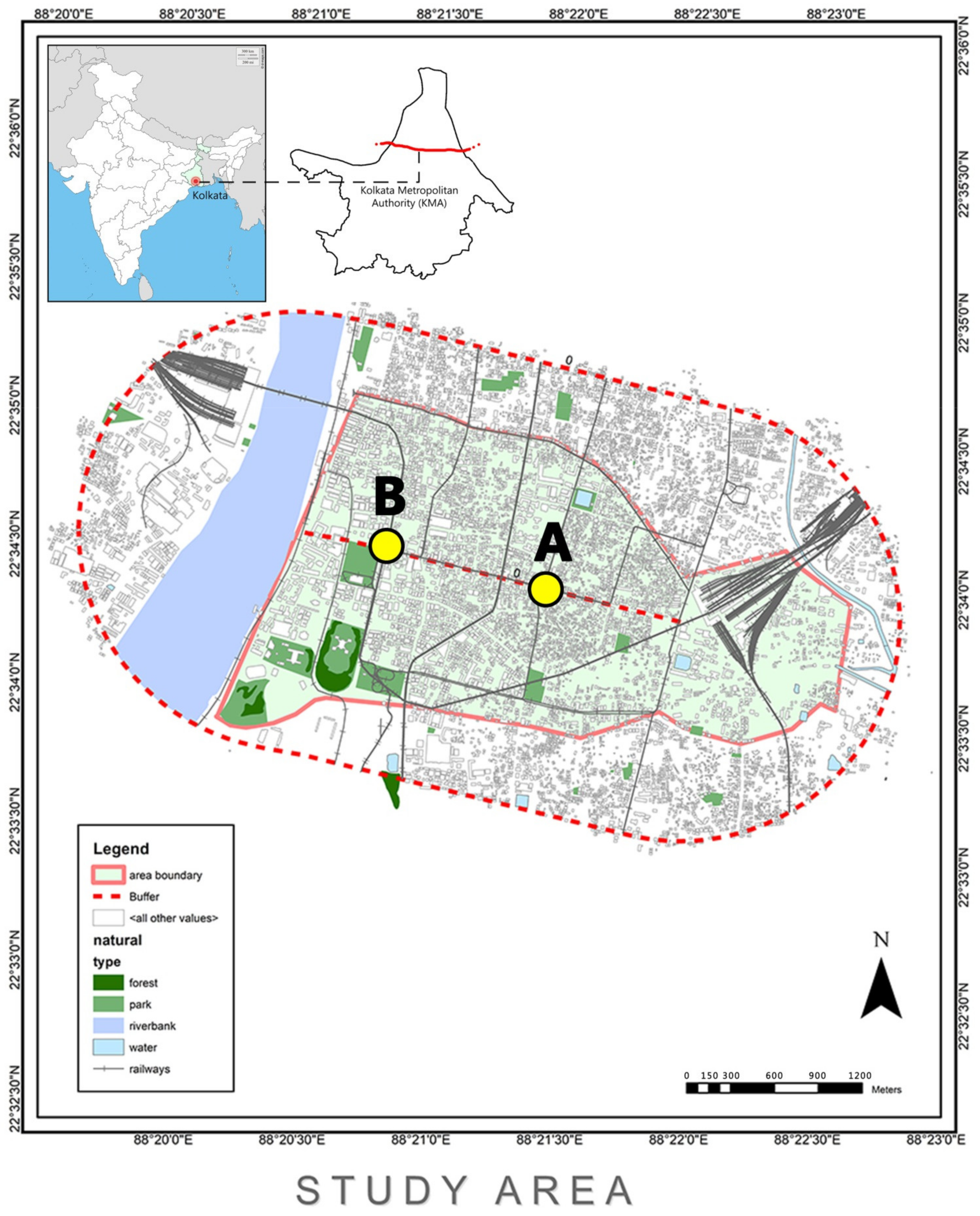
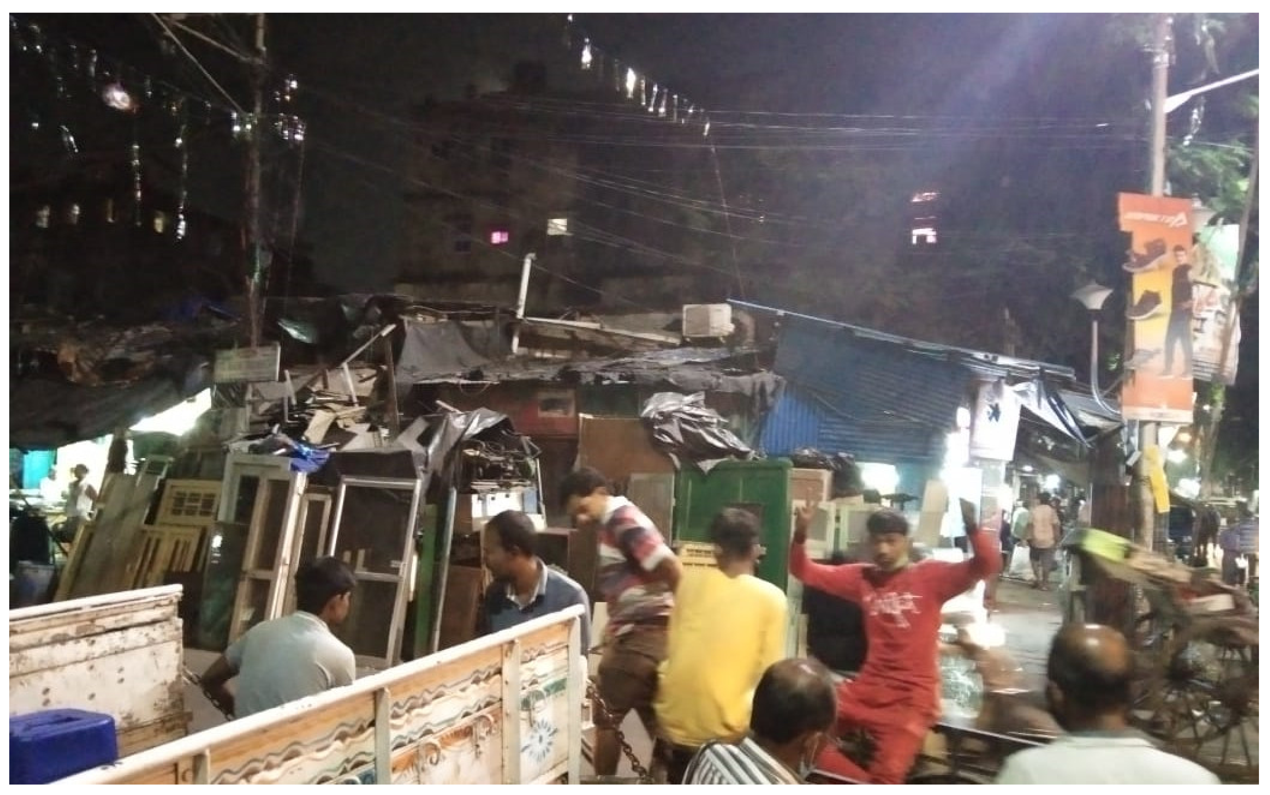
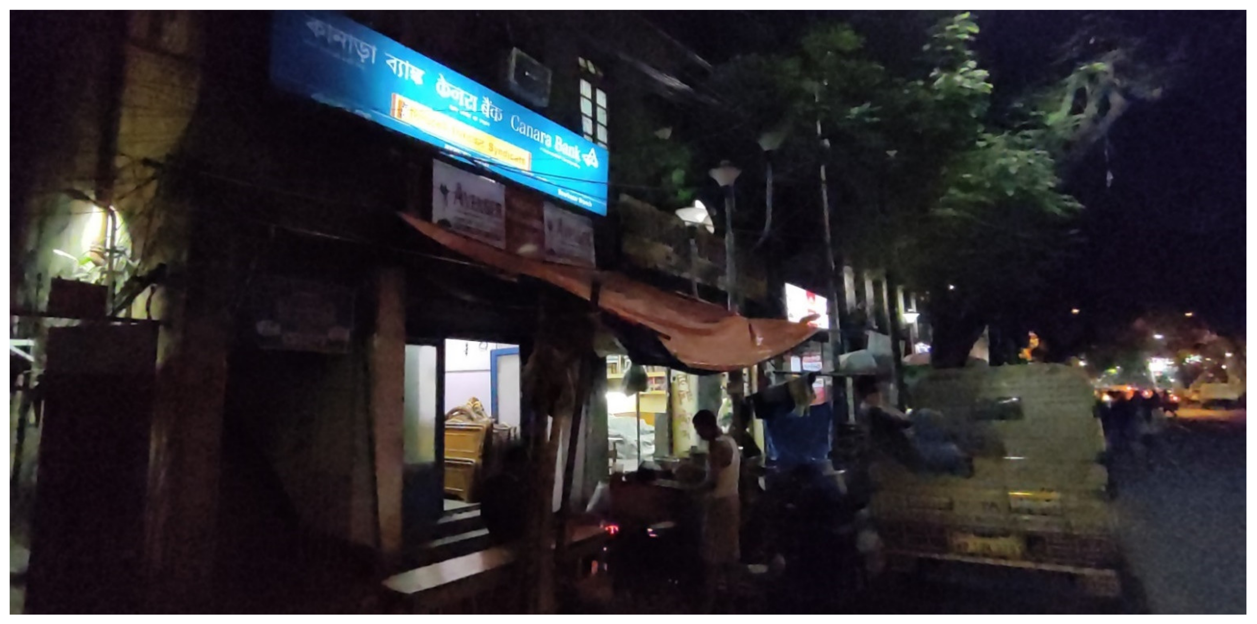
3.3. Visual Observation of an Old City Core
3.3.1. Visual Survey
3.3.2. Observation and Analysis
3.3.3. Findings and Discussion
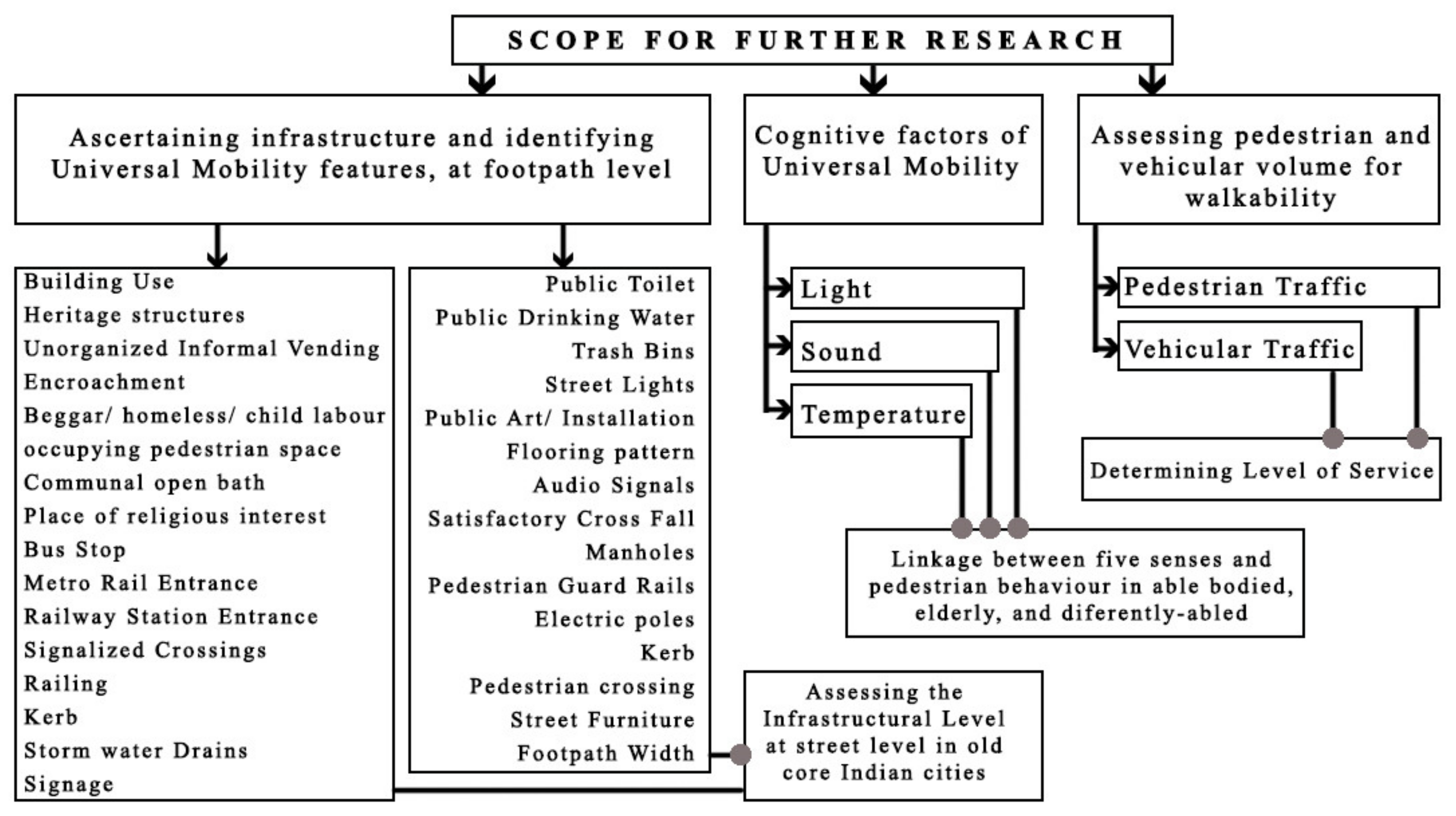
4. Major Findings
4.1. Finding 01
4.2. Finding 02
4.3. Finding 03
5. Conclusions
Author Contributions
Funding
Institutional Review Board Statement
Informed Consent Statement
Data Availability Statement
Acknowledgments
- Manorama Mahanti: Retired Municipal Corporation Employee and Resident of study area [Contact: +91-6297943706]
- Disha Maity: Fourth Year Student in Bachelor of Architecture course [Contact: dishamaiti@gmail.com]
- Akash Das: Economics Graduate and Social Worker [Contact: dasakash0710@gmail.com]
- Sagnik Das: Fifth Year Student in Bachelor of Architecture course [Contact: sagnikdas565@gmail.com]
- Sandeep Pathe: Principal Architect, Studio Sakha
- P Satheesh Kumar: Professor and Dean, School of Architecture and Interior Design, SRM Institute of Science and Technology, Kattankulathur
- Anjali S. Patil: Associate Professor, Department of Architecture, Madhav Institute of Technology and Science, Gwalior
- S. Kumar: Professor and Principal, Jawaharlal Nehru Architecture and Fine Arts University, Hyderabad
- Uma Jadhao: Professor and Principal, School of Architecture, DY Patil University, Pune
- B. Rajendra Koli: Professor and Principal, Akhil Bharatiya Maratha Sikshan Parishad’s Anantarao Pawar College of Architecture, Pune
- Neeraj Gupta: Professor and Head, School of Architecture, Central University, Ajmer
- Uma Ranganathan: Professor and Principal, Rajalakshmi School of Architecture, Mevalurkuppam
- Vasanti Londhe: Professor and Principal, Marathwada Mitramandal’s Institute of Environment and Design’s College of Architecture, Pune
- Tanya Gupta: Professor and Head of the Department, School of Architecture, Delhi Technical Campus, Noida
- Dipankar Sinha: Retired Director General, Town Planning Division, KMC
Conflicts of Interest
References
- Social Statistics Division, Ministry of Statistics and Programme Implementation. Disabled Persons in India—A Statistical Profile 2016; Government of India: New Delhi, India, 2016. [Google Scholar]
- Central Statistics Office, Ministry of Statistics and Programme Implementation. Elderly in India; Government of India: New Delhi, India, 2016. [Google Scholar]
- Solanki, S.K.; Khare, R. Universal Design Building Standard for INDIA: A Critical Inquiry. In Transforming our World through Design, Diversity and Education, Proceedings of the Universal Design and Higher Education in Transformation Congress 2018, Dublin Castle, Ireland, 30 October–2 November 2018; Craddock, G., Doran, C., Mcnutt, L., Rice, D., Eds.; Ios Pr Inc.: Dublin, Ireland, 2018; pp. 669–678. [Google Scholar]
- United Nations. Convention on the Rights of Persons with Disabilities and Optional Protocol; United Nations: Geneva, Switzerland, 2008. [Google Scholar]
- United Nations Department of Economic and Social Affairs. Goal 11: Make Cities and Human Settlements Inclusive, Safe, Resilient and Sustainable. from United Nations Department of Economic and Social Affairs (Sustainable Development). 2015. Available online: https://sdgs.un.org/goals/goal11 (accessed on 14 January 2021).
- Mahapatra, G.D.; Mandal, N.R. Accessibility in core areas of cities; Case Study: Road Stretches in Shimla, Himachal Pradesh, India. Des. All Newsl. 2018, 13, 10–33. [Google Scholar]
- Mahapatra, G.D.; Mandal, N.R. Re-Inventing Urban Spaces by Accessing Accessibility in Old City Core: A Case of Kolkata; Lap Lambert Academic Publishing: Chisinau, Mauritius, 2019. [Google Scholar]
- Mahapatra, G.D.; Devanath, J.K.; Chakraborty, S. Inclusivity in Indian Spatial Standards: A changing paradigm. In Arte: An Architectural Anthology; Singla, A., Ed.; Appreciation Arte: New Delhi, India, 2021; pp. 58–84. [Google Scholar]
- Raheja, G.; Jaiswal, S. Universal Design for Indian Public Transportation Systems. In Universal Design 2014: Three Days of Creativity and Diversity; Caltenco, H., Hedvall, P.-O., Larsson, A., Rassmus-Grohn, K., Rydeman, B., Eds.; IOS Press: Lund, Sweden, 2014; pp. 441–442. [Google Scholar]
- Babinard, J. Accessible and Inclusive Transport: Can We Achieve it? From World Bank Blogs. 8 July 2010. Available online: https://blogs.worldbank.org/transport/accessible-and-inclusive-transport-can-we-achieve-it (accessed on 3 January 2021).
- Caywood, M.; Roy, A. Universal Basic Mobility Is Coming. And It’s Long Overdue. From Bloomber CityLab. 4 October 2018. Available online: https://www.bloomberg.com/news/articles/2018-10-03/universal-basic-mobility-is-a-human-right (accessed on 4 January 2021).
- Department of Empowerment of Persons with Disabilities, Ministry of Social Justice and Empowerment. Accessible India Campaign; Accessible India—Empowered India; Government of India: New Delhi, India, 2015. [Google Scholar]
- Mace, R. Universal Design: Barrier free environmment for everyone. Des. West 1985, 33, 147–152. [Google Scholar]
- Kumar, S.G.; Roy, G.; Kar, S.S. Disability and Rehabilitation Services in India: Issues and Challenges. J. Fam. Med. Prim. Care 2012, 1, 69–73. [Google Scholar] [CrossRef] [PubMed]
- Minucciani, V.; Nilufer, S. Well-being age and space. J. Urban Des. 2020, 25, 275–286. [Google Scholar] [CrossRef]
- Goldsmith, S. Universal Design: A Manual of Practical Guidance for Architects; Architectural Press: Oxford, UK, 2000. [Google Scholar]
- Heylighen, A.; Linden, V.; Steenwinkel, I. Ten questions concerning inclusive design of the built environment. Build. Environ. 2017, 114, 507–517. [Google Scholar] [CrossRef]
- Herring, E. Design for Inclusivity: A Practical Guide to Accessible, Innovative and User-Centred Design. In Design and Culture; Coleman, R., Clarkson, J., Dong, H., Cassim, J., Eds.; Taylor and Francis: Abingdon-on-Thames, UK, 2015. [Google Scholar]
- Story, M.F.; Mueller, J.; Mace, R. The Universal Design File: Designing for People of All Ages and Abilities; Center For Universal Design, NC State University: Raleigh, NC, USA, 1998. [Google Scholar]
- Story, M.F. Maximizing Usability: The Principles of Universal Design. Assist. Technol. Off. J. Resna 1988, 10, 4–12. [Google Scholar] [CrossRef] [PubMed]
- Steinfeld, E.; Danford, G. Theory as a Basis for Research on Enabling Environments. In Enabling Environments: Measuring the Impact of Environment on Disability and Rehabilitation; Steinfeld, E., Danford, G., Eds.; Springer: Berlin/Heidelberg, Germany, 1999; pp. 5–9. [Google Scholar]
- Steinfeld, E. Barrier Free Access to the Man Made Environment—A Review of Current Literature; Department of Housing and Urban Development: Washington, DC, USA, 1975. [Google Scholar]
- Maisel, J.L.; Steinfeld, E.; Basnak, M.; Smith, K.; Tauke, M. Inclusive Design. In Pocket Architecture: Technical Design Series; Smith, R.E., Ed.; Routledge: New York, NY, USA, 2018; pp. 4–95. [Google Scholar]
- Basbas, S.; Mintsis, G.; Oikonomou, K.; Taxiltaris, C. Design of a sustainable and accessible environment in central areas. Sustain. Dev. Plan. 2005, 84. [Google Scholar] [CrossRef]
- Akiyama, T.; Kim, J.-k. Transportation Policies for the Elderly and Disabled in Japan. Int. J. Urban Sci. 2011, 9, 87–98. [Google Scholar] [CrossRef]
- Rahman, M.T.; Nahiduzzaman, K. Examining the Walking Accessibility, Willingness, and Travel Conditions of Residents in Saudi Cities. Int. J. Environ. Res. Public Health 2019, 16, 545. [Google Scholar] [CrossRef] [PubMed]
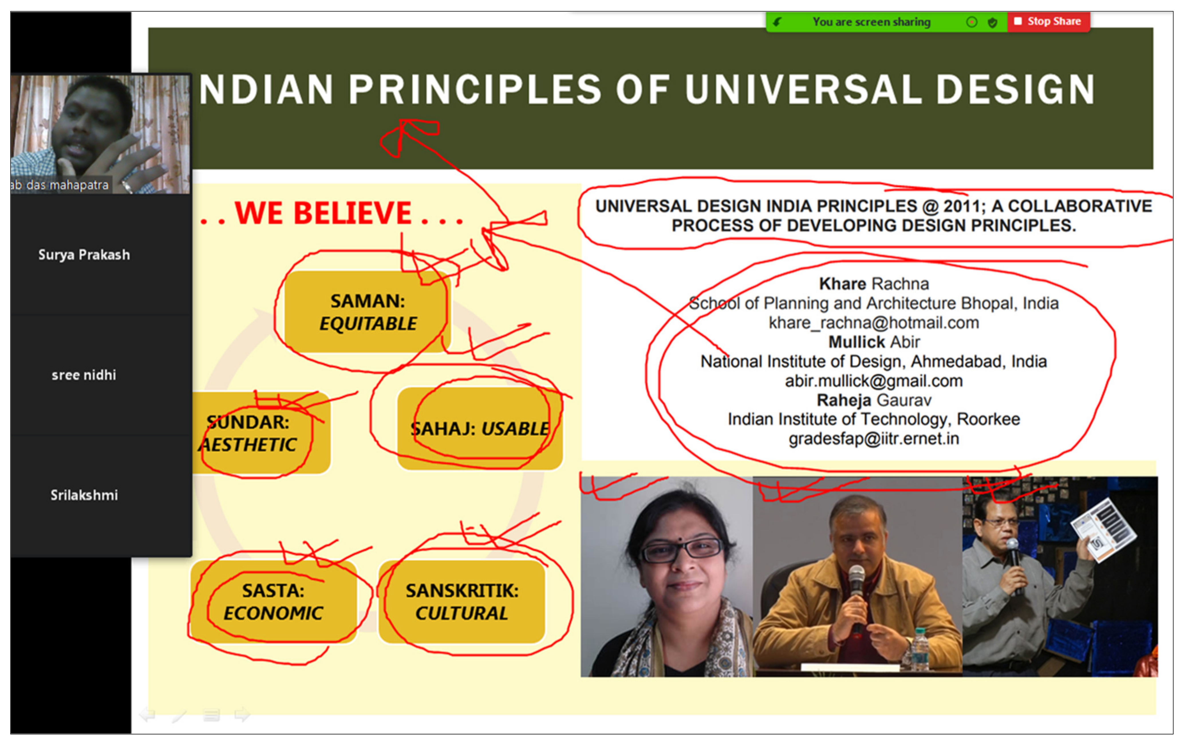
- Khare, R.; Mullick, A.; Raheja, G. Universal design India principles @ 2011; a collaborative process of developing design principles. Transed 2012, 2011, 1–8. [Google Scholar]
- Gupta, S.; Witte, L.; Meershoek, A. Dimensions of invisibility: Insights into the daily realities of persons with disabilities living in rural communities in India. Disabil. Soc. 2020, 1–23. [Google Scholar] [CrossRef]
- Preiser, W.F.; Smith, K. (Eds.) Universal Design Handbook, 2nd ed.; McGraw-Hill: New York, NY, USA, 2010. [Google Scholar]
- Levine, D. (Ed.) Universal Design New York; IDEA Publications—Center for Inclusive Design and Environmental Access, University at Buffalo: Buffalo, NY, USA, 2003. [Google Scholar]
- Mahmoudi, A.; Fanaei, K. Revision of urban spaces to make it accessible for disabled people in order to achieve the aim of “city for all”. In REAL CORP 2010 Proceedings; Real Corp: Vienna, Austria, 2010; pp. 1217–1222. [Google Scholar]
- Frye, A. Growing Old in the City. J. Urban Des. 2014, 19, 269–274. [Google Scholar] [CrossRef]
- Mori, S.; Funahashi, K.; Takeshi, S.; Michihiro, K. A study on methodology of ethnomethodology: Ethnomethodology in housing environment design 1. J. Archit. Plan. Environ. Eng. 2001, 540, 181–187. [Google Scholar]
- Mori, S.; Oku, T.; Hasegawa, M. Characteristics of action in strolling behaviour-A basic study on act-finding in Urban Space. In Proceedings of the 5th International Symposium for Environment-Behaviour Studies. 1; Leiqing, X., Ed.; EBRA (Environmnet Behaviour Research Association), College of Architecture and Urban Planning, Tongii University: Shanghai, China, 2002; pp. 138–144. [Google Scholar]
- Do, T.D.; Mori, S.; Nomura, R. Passenger’s Attention Behaviors along Street Space: A Case Study of Da Nang City. J. Civ. Eng. Archit. 2018, 12, 245–261. [Google Scholar]
- Espina, J.M.; Mori, S.; Nomura, R. An Analysis of Environment Behavior Relationships towards the Design of a Local Mixed-used Street: Based on Behavior Settings of Belgium Street in Cebu City, Philippines. Sustainability 2018, 10, 3230. [Google Scholar] [CrossRef]
- Preiser, W.F. Universal design: From policy to assessment research and practice. Arcnet IJAR 2008, 2, 78–93. [Google Scholar]
- Mrak, I.; Campisi, T.; Tesoriere, G.; Canale, A.; Cindrić, M. The role of urban and social factors in the accessibility of urban areas for people with motor and visual disabilities. AIP Conf. Proc. 2019, 2186, 160008. [Google Scholar]
- Mahapatra, G.D. Reinterpreting Urban Fabric in Cities with Living Heritage: The Case of Central Kolkata; Mitra, T., Ed.; Copal Publishing: New Delhi, India, 2020. [Google Scholar]
- Nag, P. City of Calcutta and its Environs, 3rd ed.; National Atlas and Thematic Mapping Organization: Kolkata, India, 2010. [Google Scholar]
- Raju, G.N. The Constitution of India [As on 31 July 2018]; Legislative Department, Ministry of Law and Justice, Government of India: New Delhi, India, 2018. [Google Scholar]
- Ostroff, E. International Design Education Strategies. In Inclusive Design; Clarkson, P., Coleman, R., Keates, S., Lebbon, C., Eds.; Springer: London, UK, 2003; pp. 338–354. [Google Scholar]
- NIUA. Project Details: BASIIC. 1 August 2019. Available online: https://www.niua.org/projectdetails?pid=26 (accessed on 6 January 2021).


| S. no. | Date | Type of Session | Title of Session | Location |
|---|---|---|---|---|
| 1 | 25–28 June | Summer Studio | Universal Design | SAKHA, Nagpur |
| 2 | 27–29 July | Workshop | Being Creatively Rational | School of Architecture and Interior Design, SRM Institute of Science and Technology, Kattankulathur |
| 3 | 07–09 August | Technical Education Quality Improvement Programme | Universal Design: Architecture for All | Department of Architecture, Madhav Institute of Technology and Science, Gwalior |
| 4 | 14 August | Webinar Series | Universal Design and Accessibility—A route towards Sustainability | Jawaharlal Nehru Architecture and Fine Arts University, Hyderabad |
| 5 | 19–21 August | Workshop | An Architect’s Approach towards Universal Design and Accessibility | School of Architecture, DY Patil University, Pune |
| 6 | 28 August | Semester Coursework Expert Lecture | Universal Design Approach | Akhil Bharatiya Maratha Sikshan Parishad’s Anantarao Pawar College of Architecture, Pune |
| 7 | 05 October | Webinar | Universal Design | School of Architecture, Central University, Ajmer |
| 8 | 06 October | Guest Lecture | Being Creatively Rational | Rajalakshmi School of Architecture, Mevalurkuppam |
| 9 | 06–08 October | Semester Coursework Expert Lecture | Universal Design and Accessibility | Marathwada Mitramandal’s Institute of Environment and Design’s College of Architecture, Pune |
| 10 | 28–29 October | Workshop | Being Creatively Rational | School of Architecture, Delhi Technical Campus, Noida |
| 11 | 08 November | Institute of Town Planning Annual Lecture | Assessing accessibility for equitable planningwith focus on disabled and elderly | Institute of Town Planners India, Kolkata |
| S. No | Topic | Learning |
|---|---|---|
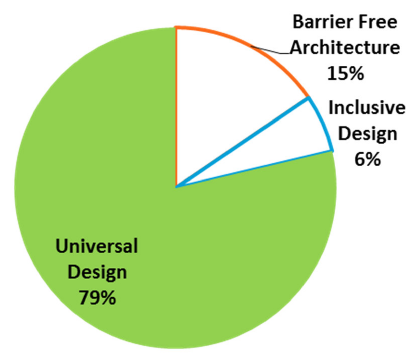
| 1 | Importance of Universal Design in Architecture and Planning | Unlike a few decades back, Barrier-Free architecture and Inclusive Design are relatively outdated. The present need for India is Universal Design. |
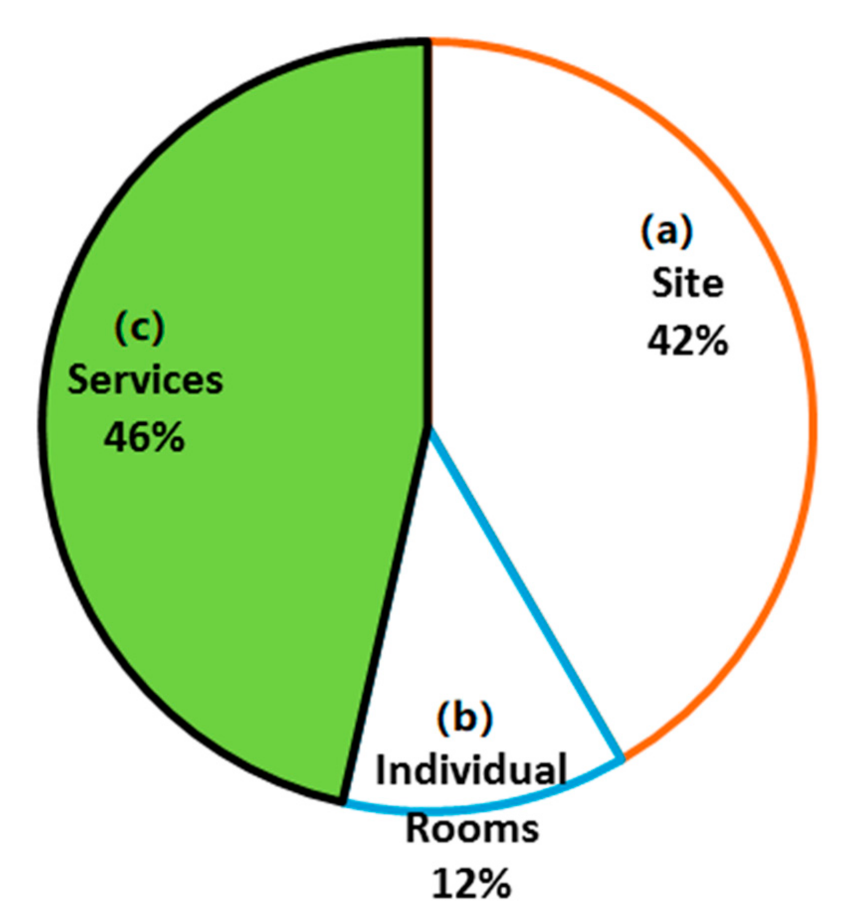
| 2 | Prioritization of site level and services in Universal Design | Universal Design is necessary, and within it, “SITE and SERVICES” should be the priority. However, the focus of all existing Indian guidelines is “Building Specific” or rather, towards Individual enclosed spaces. |
| 3 | Differences in an accessibility scenario between old core cities and new planned cities in India | In India, new cities and old cities need different Universal Design guidelines, calling for constructive criticism of the latest national policies. |
| 4 | Level of difficulty in old core cities in India | Different Universal Design guidelines are required for old and new cities due to their differences in spatial evolution/temporal growth, institutional mechanisms, infrastructural patterns, and demographic reasons. |
| 5 | Impact of present national campaigns towards inclusive planning | Although National Policies are satisfactory, initiating a case-specific approach or a flexible assessment pattern is ideal. |
| 6 | Position of “Transportation and Accessible Information” in Universal Design | Pan-India, accessible transportation is an issue. Instead of focusing on building or technology-oriented accessibility, the government should focus on making the transportation system accessible. In infrastructural terms, accessible streets and accessible mobility is needed. |
| 7 | Need for customized rating system in Universal Design | A new “Rating/Indexing” system in Universal Design makes the Universal Design scenario more quantitative in analytical terms. Thus, the scope for intervention in infrastructural terms based on the data derived from rating systems might be used for promoting inclusiveness. |
| S.No | Type of Disability | Recognized by “Right to Persons with Disabilities Act, 2016” | Number of Respondents | Percentage of Respondents |
|---|---|---|---|---|
| 1 | Low Vision | Yes | 6 | 28.57 |
| 2 | Locomotor Disability | Yes | 11 | 52.38 |
| 3 | Arthritis | No | 2 | 9.52 |
| 4 | Asthma | No | 1 | 4.76 |
| 5 | Cancer | No | 1 | 4.76 |
| S.No | Topic | Learning |
|---|---|---|
| 1 | Frequency and purpose of going out |
|
| 2 | Searching/ identification of an address |
|
| 3 | Walkability |
|
| 4 | Awareness about National Schemes |
|
| S.No | Topic | Inference |
|---|---|---|
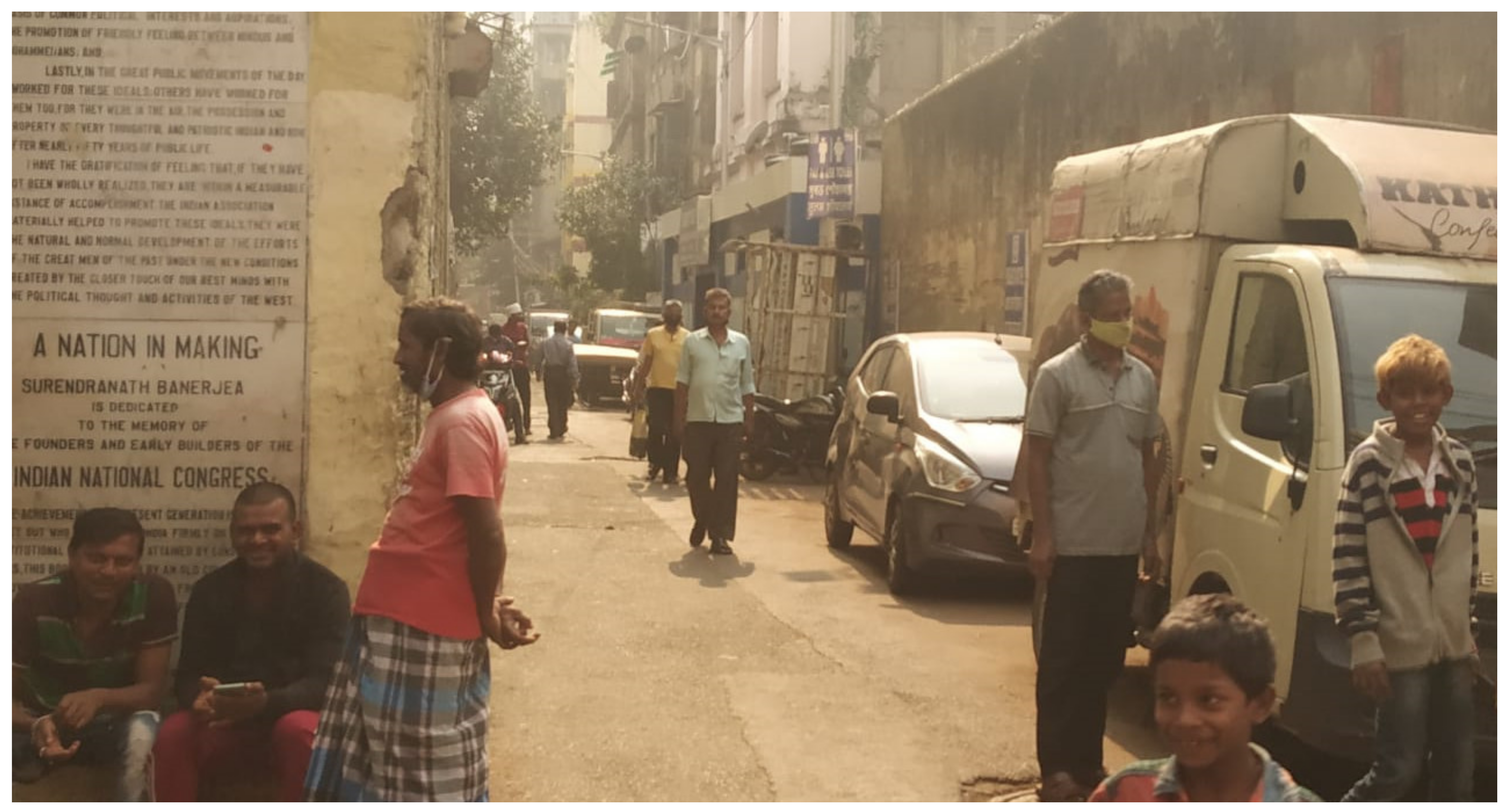
| 1 | Predominant building use | The mixed land use and multiplicity of usage in a single building creates a complex structure of users. A different activity such as educational, business and others create multiple “peak hour traffic” which the present infrastructure is not adequate to cater. |
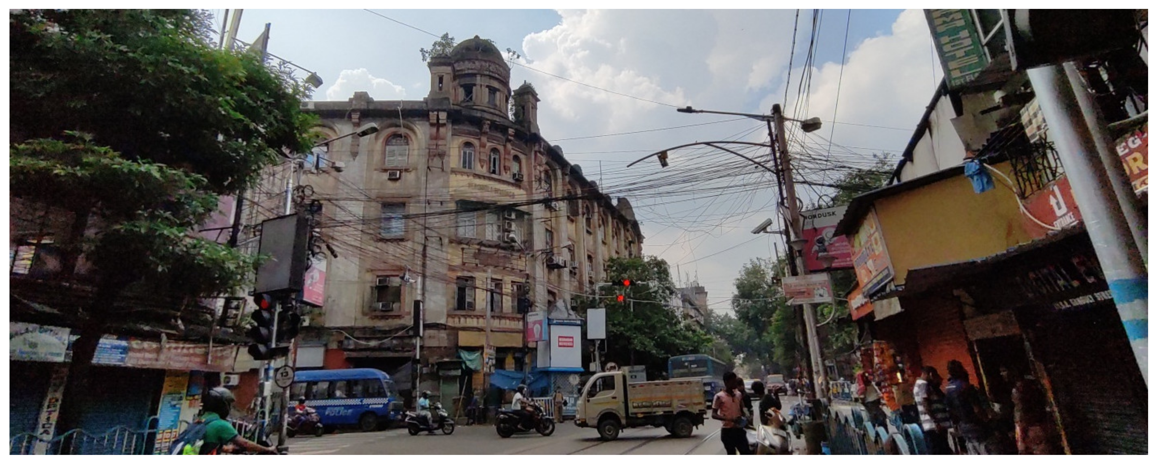
| 2 | Heritage buildings | A large number of Heritage buildings fostered low temporal change and is also restricting alteration in the width of carriageways. Typical heritage buildings with no setback and footpaths are not segregated from the building entrances creates a pedestrian discomfort in this stretch. |
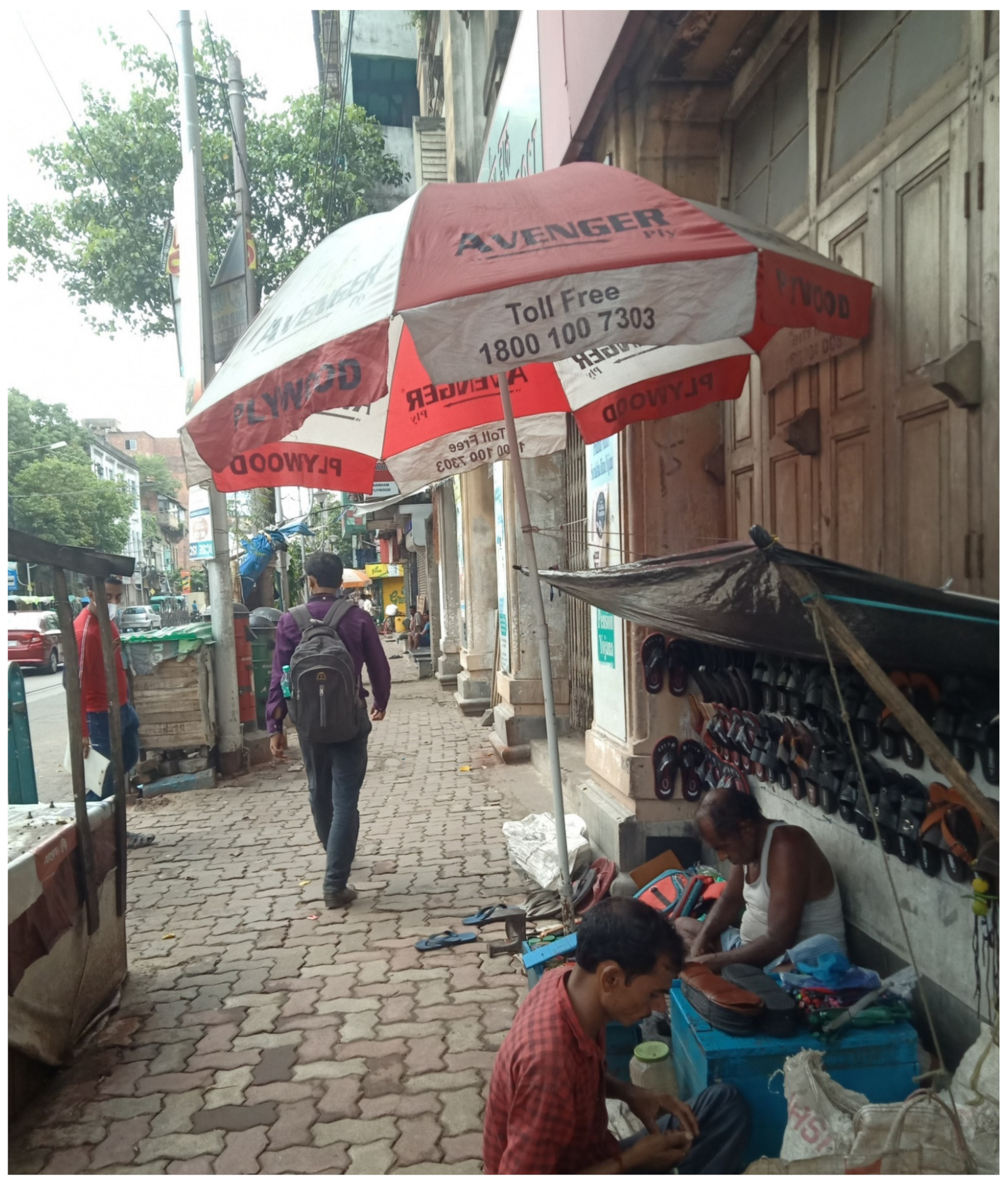
| 3 | Informal vending | Since the inception of this stretch, informal vending has been a characteristic feature. However, with increasing population and vehicular pressure, the informal vendors are presently a threat to mobility. |
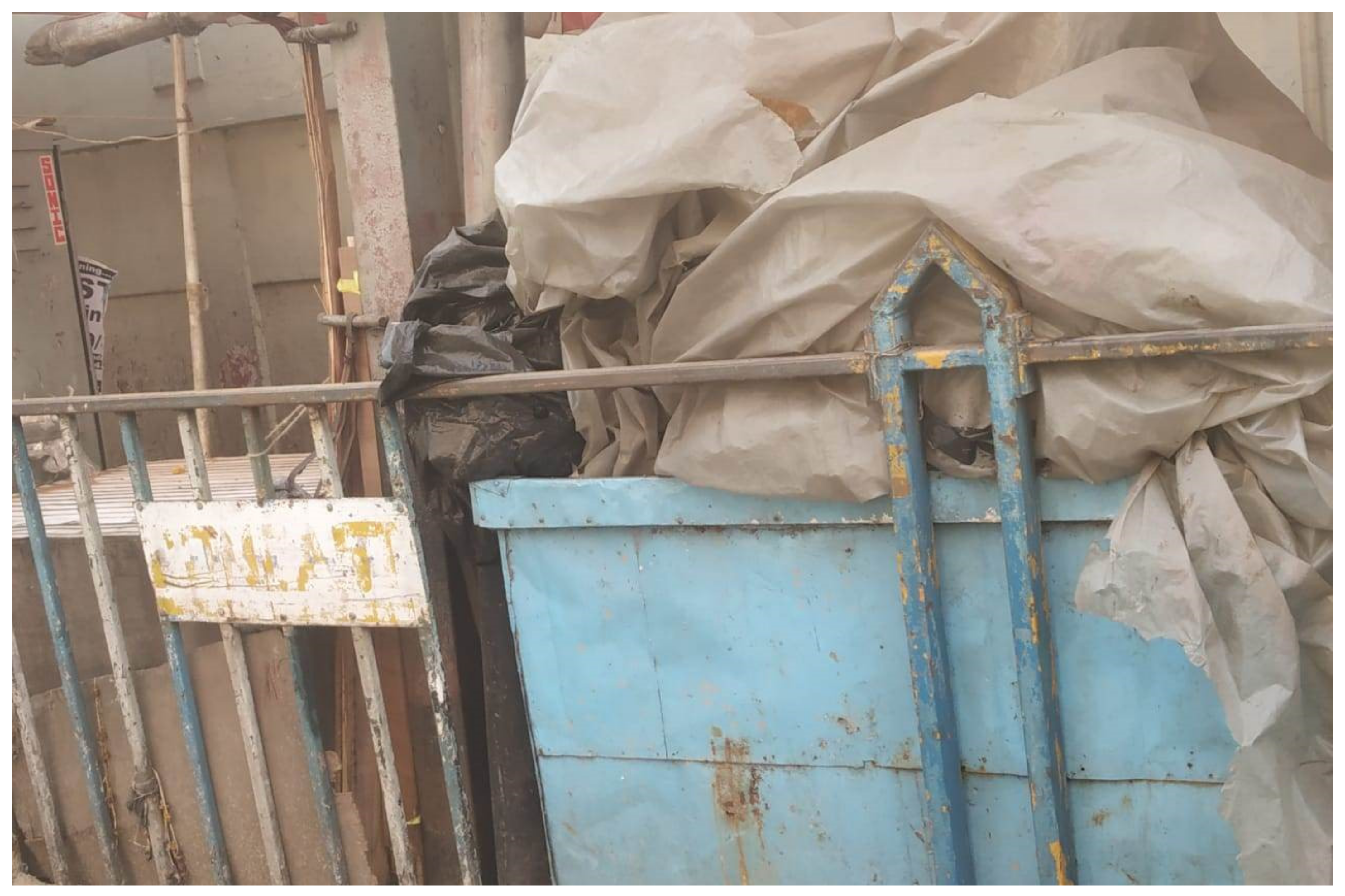
| 4 | Encroachment | Encroachment is a policy failure. Illegally occupied spaces within footpath create severe problems during peak hours. |
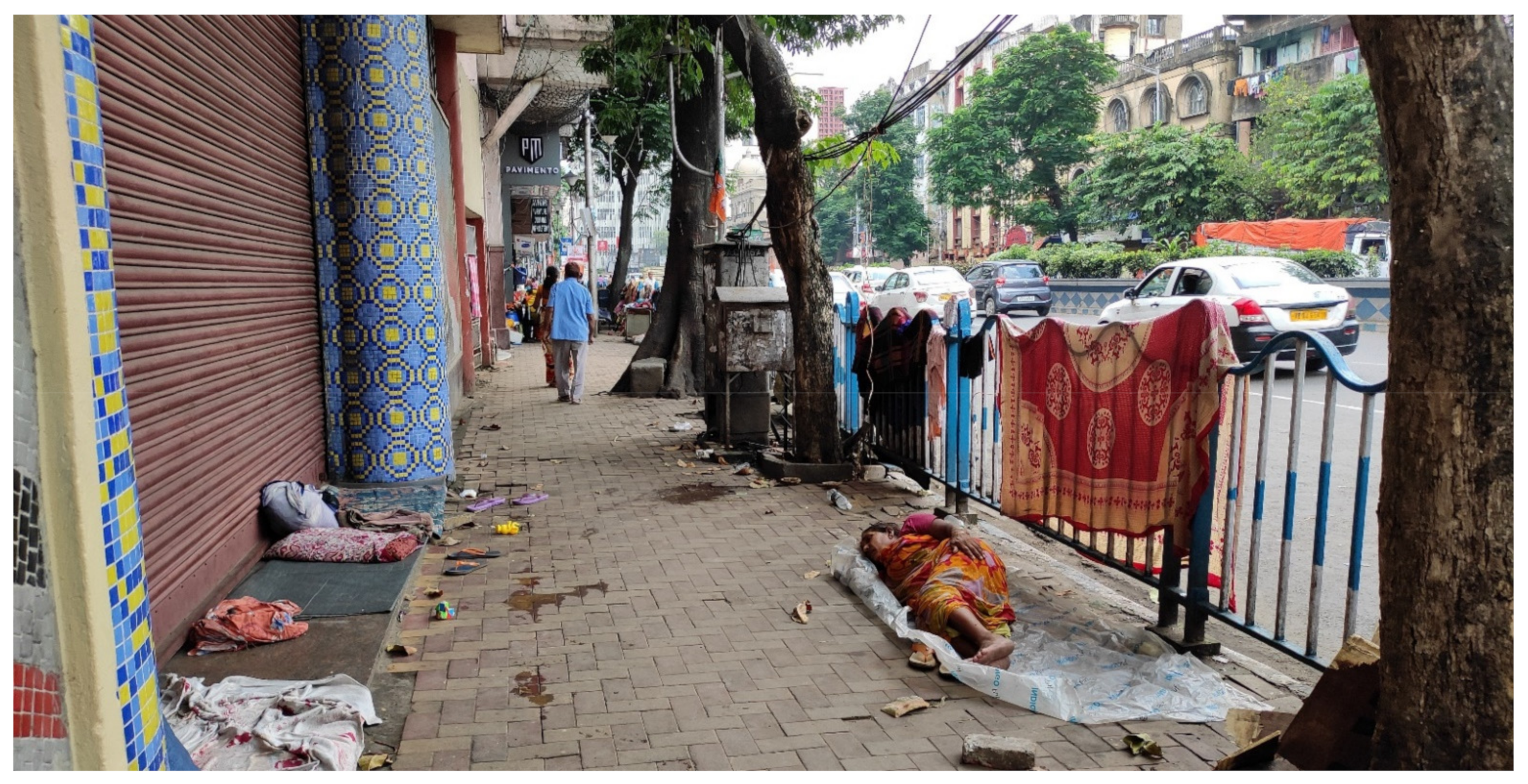
| 5 | Beggar/homeless/child labour | Beggar/homeless/child labour is a social issue. Only socio-political intervention can facilitate the process of emptying the streets of these user groups. |
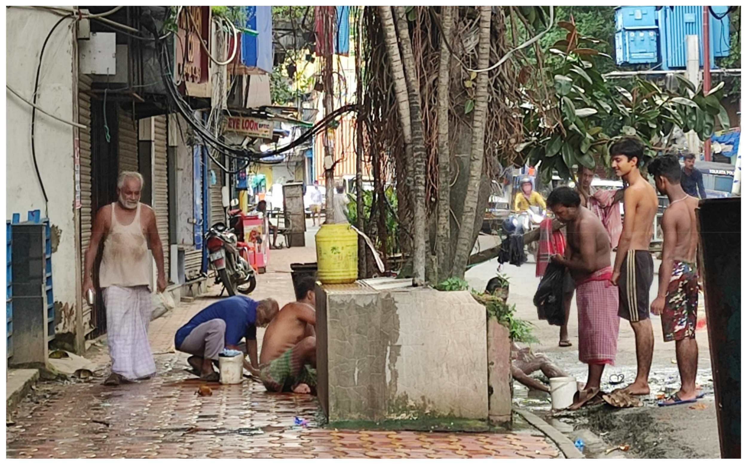
| 6 | Communal open bath | Communal open baths are obsolete in most parts of the city except central part of Kolkata. These communal open baths (often at the edge of footpath and street) serve as an important functional social infrastructure due to the presence of many daily wage workers and floating population. On the contrary, the baths are posing threat to mobility on both footpath and street. The common baths create an extra crowd and spilt water, both of which are threatening to the pedestrian environment. |
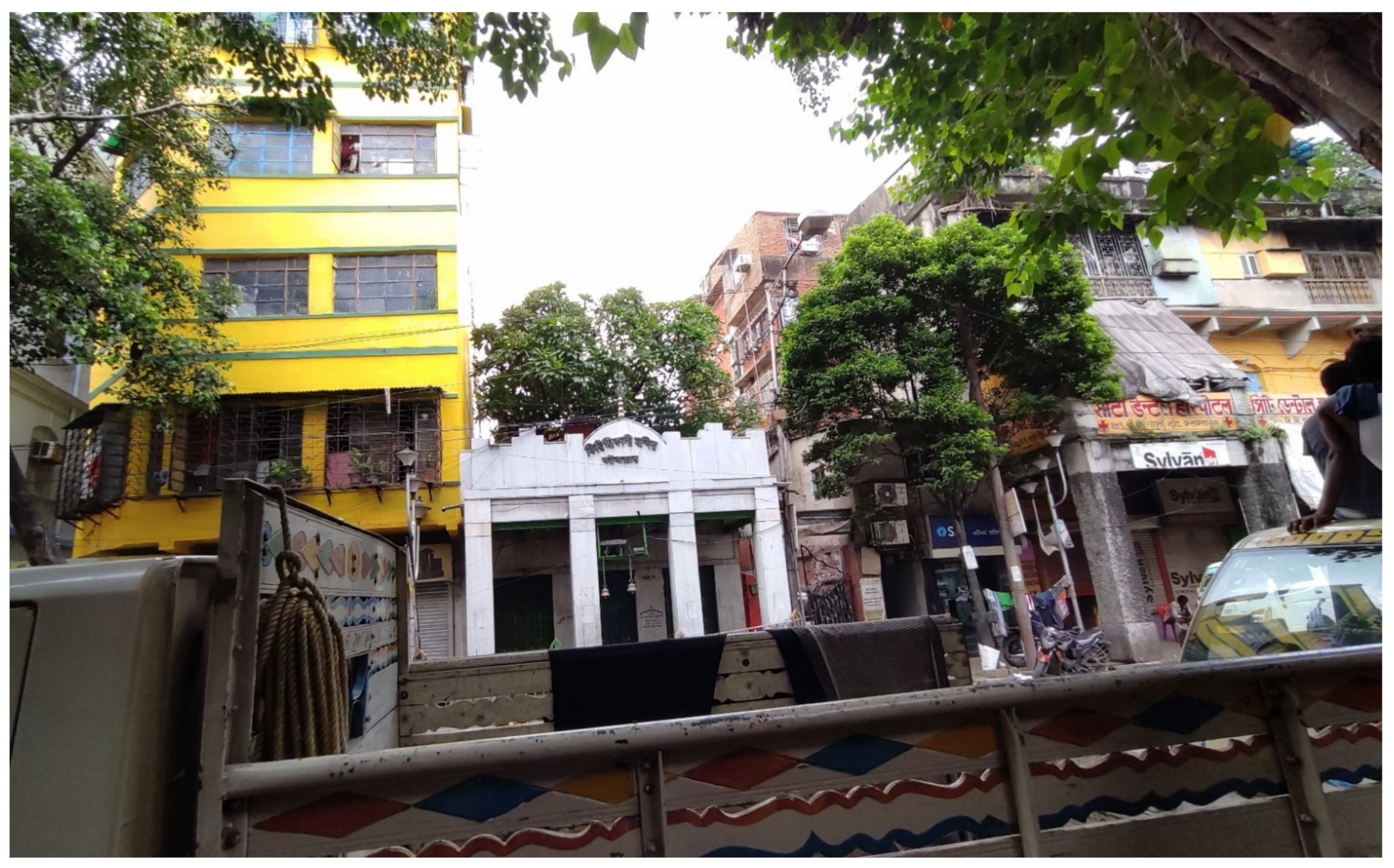
| 7 | Religious establishments | Being an organically developed area within historic core, Hindu, Muslim and Christian crowds are proportionately present. The “Firinghi Kali Bari” Temple and “St. Xavier’s Church” are examples of religious structures. The problems with these locations are their presence along the footpath and absence of alternative entry. So, during prayers hours, a conflict in pedestrian movement due to different user group at the same line of movement is observed. |
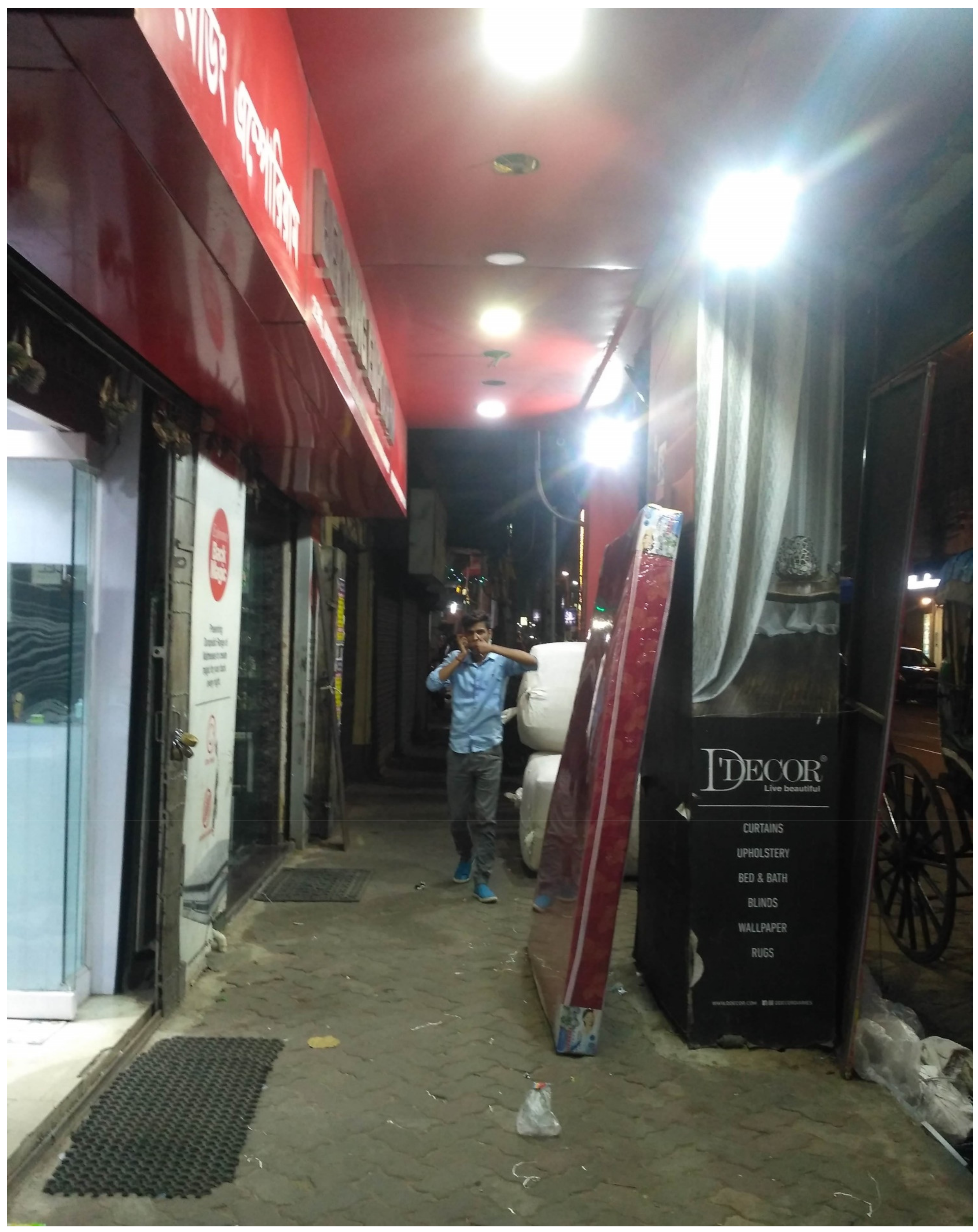
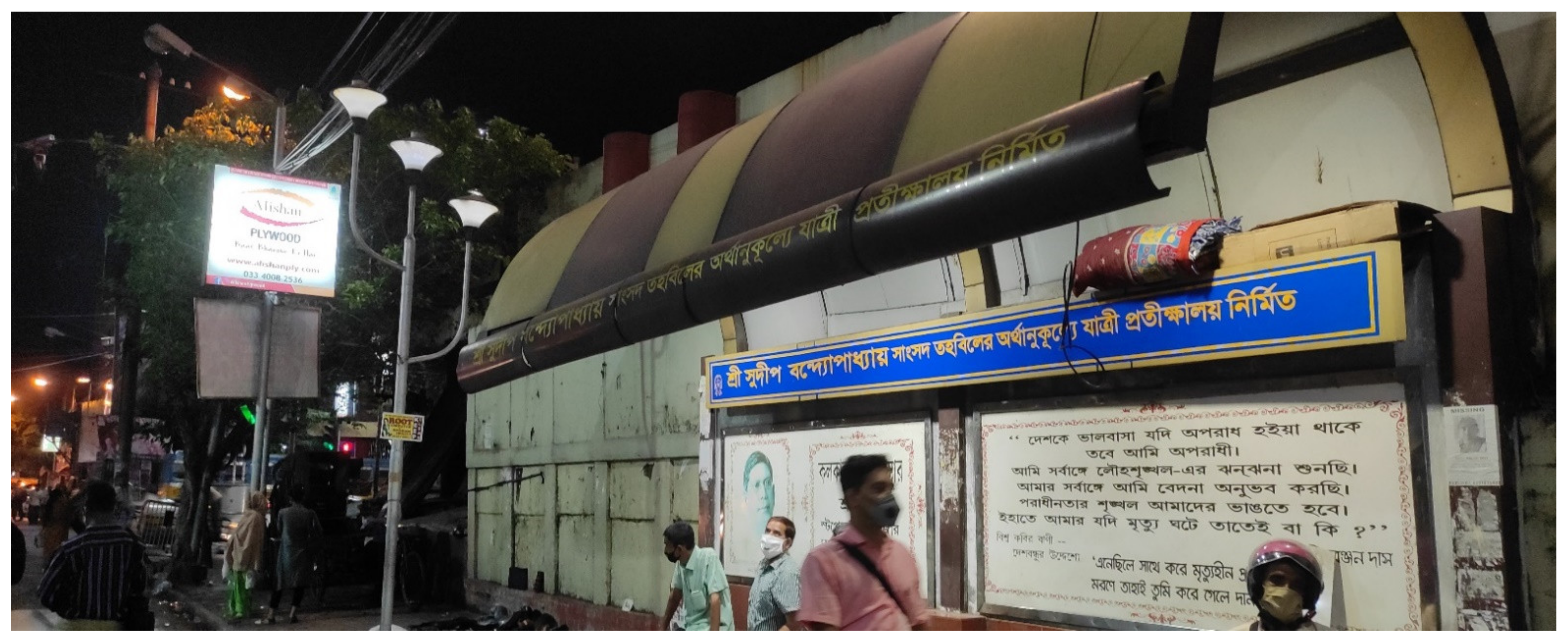
| 8 | Bus stop | The bus stops are in dilapidated condition and used by homeless people to store their belongings. Provision of information display is absent in bus stops; rather, the bus stops are used more for advertising purposes. A bus stop without facilities and improper information display is of seldom use in the 21st century. |
| 9 | Metro stations | The unused metro station gates are occupied by homeless people as their temporary shelter. These issues are to be solved at the policy and socio-political level. |
| 10 | Signalized intersections | Allocation of signals at intersections in this stretch was done decades ago in this stretch. The new zones of pedestrian and vehicular traffic have not been considered in the recent past. Due to different building use, the volume of traffic is varying. The concept of allocating signals based on road width might not be suitable for this area. Rather, signals based on traffic volume and predominant building uses are apt for this stretch. |
| 11 | Railing | Informal vendors occupied the railings in most parts of the stretch. Neither a clear demarcation for the pedestrian and vehicular traffic, nor scope for elderly/differently-abled people who needs to hold the railing, is present. A clear edge is essential for an ideal streetscape. |
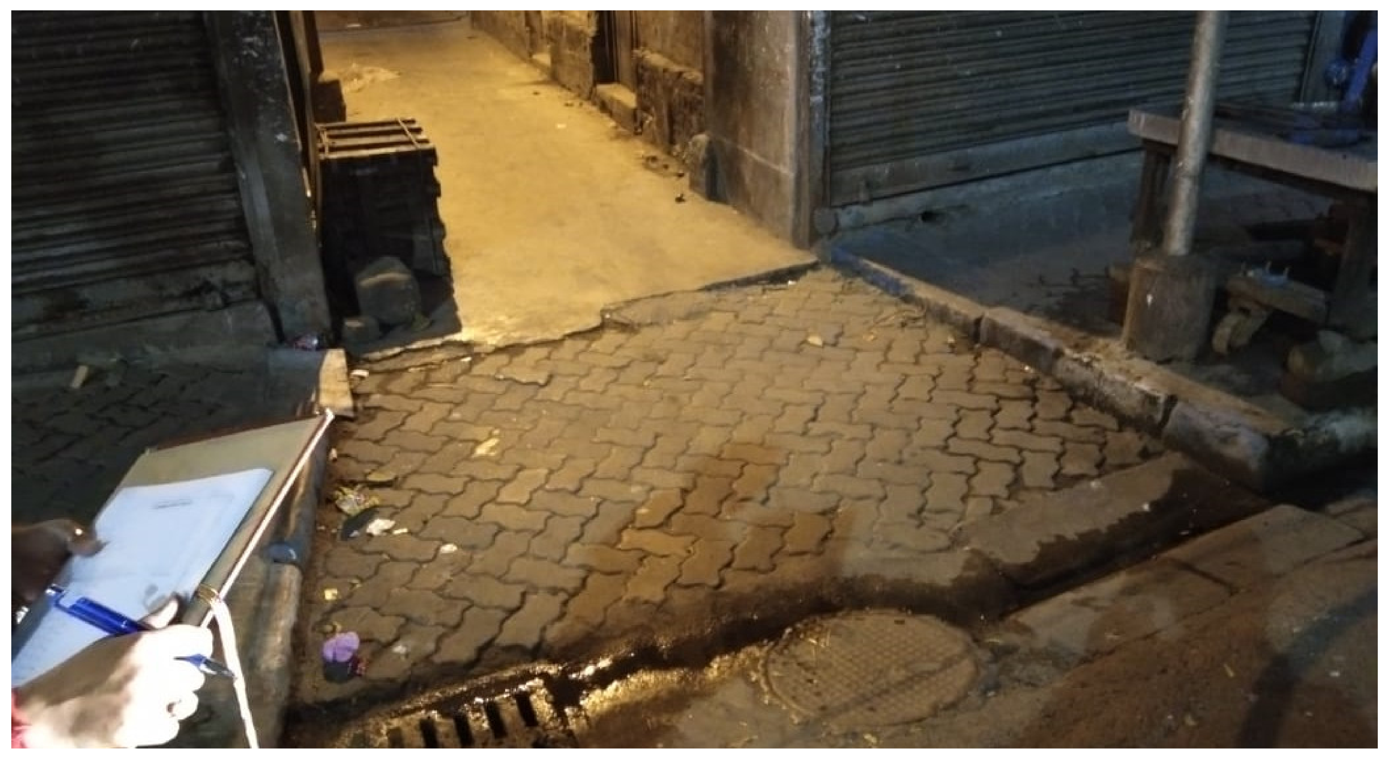
| 12 | Kerb | Kerb which essentially provides gradation in street-level mobility is in extremely dilapidated condition in this stretch. As a result, neither able-bodied pedestrians nor differently-abled people are able to move freely in the footpaths. The scenario worsens at night due to lack of adequate light. |
| 13 | Storm water drains | Storm water circulation in this part of Central Kolkata is better than most of the parts; however, the location of storm water drains are a matter of major concern. The location, grating style and the slope is dangerous for pedestrian, especially the ones with walking cane. |
| 14 | Signage | There was no directional signage in the entire stretch. Public utilities are not demarcated. The historic buildings had their description engraved near the entrance. However, other places of public interest are not having any information. Thus, for people new to this area and people with cognitive issues, they face difficulty in traversing the stretch. |
| 15 | Public Toilet, Drinking water facilities, and resting facilities | Only one public toilet was observed in the entire stretch of 850 m in which visual observation was undertaken and no drinking water facility was present. Public facilities such as drinking water and public toilets complemented by street furniture are components of a healthy street. Mobility without public facilities is unreasonable in the urban scenario. |
| 16 | Trash Bins | According to the latest “Swachh Survekshan” programme or Clean India Campaign launched in 2016, Trash bins are to be placed at fifty meters interval along urban streets. However, in this stretch, hardly any trash bins were observed and as a result, a littering was observed. Clean streets promote increased mobility and should be taken care of. |
| 17 | Street Lights | In spite of the fact that street lights are present all throughout the stretch, the requisite lighting intensity was not present. When checked using the “Light meter” application, most of the streets showed a lux level of less than ten, which is not ideal for a safe pedestrian environment. The fact that this stretch experiences a heavy pedestrian footfall, poor lighting makes it even more vulnerable to users with cognitive difficulties. |
Publisher’s Note: MDPI stays neutral with regard to jurisdictional claims in published maps and institutional affiliations. |
© 2021 by the authors. Licensee MDPI, Basel, Switzerland. This article is an open access article distributed under the terms and conditions of the Creative Commons Attribution (CC BY) license (https://creativecommons.org/licenses/by/4.0/).
Share and Cite
Mahapatra, G.D.; Mori, S.; Nomura, R. Universal Mobility in Old Core Cities of India: People’s Perception. Sustainability 2021, 13, 4391. https://doi.org/10.3390/su13084391
Mahapatra GD, Mori S, Nomura R. Universal Mobility in Old Core Cities of India: People’s Perception. Sustainability. 2021; 13(8):4391. https://doi.org/10.3390/su13084391
Chicago/Turabian StyleMahapatra, Gaurab Das, Suguru Mori, and Rie Nomura. 2021. "Universal Mobility in Old Core Cities of India: People’s Perception" Sustainability 13, no. 8: 4391. https://doi.org/10.3390/su13084391
APA StyleMahapatra, G. D., Mori, S., & Nomura, R. (2021). Universal Mobility in Old Core Cities of India: People’s Perception. Sustainability, 13(8), 4391. https://doi.org/10.3390/su13084391