Article

Landscape Design toward Urban Resilience: Bridging Science and Physical Design Coupling Sociohydrological Modeling and Design Process

1
Department of Landscape Architecture, University of Illinois at Urbana-Champaign, Champaign, IL 61820, USA
2
School of Architecture, University of Illinois at Urbana-Champaign, Champaign, IL 61820, USA
*
Author to whom correspondence should be addressed.
Sustainability 2021, 13(9), 4666; https://doi.org/10.3390/su13094666
Submission received: 18 March 2021 / Revised: 17 April 2021 / Accepted: 19 April 2021 / Published: 22 April 2021

Abstract

:
Given that evolving urban systems require ever more sophisticated and creative solutions to deal with uncertainty, designing for resilience in contemporary landscape architecture represents a cross-disciplinary endeavor. While there is a breadth of research on landscape resilience within the academy, the findings of this research are seldom making their way into physical practice. There are existent gaps between the objective, scientific method of scientists and the more intuitive qualitative language of designers and practitioners. The purpose of this paper is to help bridge these gaps and ultimately support an endemic process for more resilient landscape design creation. This paper proposes a framework that integrates analytic research (i.e., modeling and examination) and design creation (i.e., place-making) using processes that incorporate feedback to help adaptively achieve resilient design solutions. Concepts of Geodesign and Planning Support Systems (PSSs) are adapted as part of the framework to emphasize the importance of modeling, assessment, and quantification as part of processes for generating information useful to designers. This paper tests the suggested framework by conducting a pilot study using a coupled sociohydrological model. The relationships between runoff and associated design factors are examined. Questions on how analytic outcomes can be translated into information for landscape design are addressed along with some ideas on how key variables in the model can be translated into useful design information. The framework and pilot study support the notion that the creation of resilient communities would be greatly enhanced by having a navigable bridge between science and practice.

1. Introduction

Some of the current literature in resilient systems has been introduced in an attempt to define, examine, assess, and even forecast the issue under various and changing conditions [1,2,3]. Much of this work has been conducted under a fundamental assumption that nature is continuously evolving and uncertainly changing (although the discussions have broadened over the years). The ecologist C.S. Holling [4], for example, established a seminal definition of resilience as a measure of the capacity of an ecological system to tolerate disturbance, while many more recent scholars are focused on disaster response and scenario processes as a basis for understanding the ideas [1,2,5,6]. In general, operationalizing the concept has been challenging [7], especially in the planning and design disciplines that deal with large, complex urban systems [8]. One thing, however, is becoming clear: the inherent uncertainty in urban systems requires ever more sophisticated and creative approaches in order to achieve resilient places [5,9,10].
The process of developing these creative ideas has revealed that evolving complex systems cannot be comprehensively studied (or understood) while focusing on only one particular aspect in isolation [11]. As a result, there has been an increasing call for integrative approaches to urban system dynamics and coupled human–environmental systems more broadly in the name of resilient solutions [9,12]. Some of these have included collaboration, negotiation, and cooperation across different disciplines, such as ecology, geography, engineering, and socioeconomics [13,14,15]. They suggest that the complex interactions between human and biophysical processes are best addressed and understood through cross-disciplinarity, which allows for the incorporation of dynamics and uncertainty [9,16,17].
Similarly, the field of landscape architecture—especially in complex urban areas—requires cross-disciplinarity in the design and application of ideas if resilience is an overarching goal. Landscape architecture, the purpose of which is to deal with a wide array of environmental issues and scales, can enhance its design impacts by understanding complexity, preparing for contingency, and manifesting potential in dynamic systems [15,18]. This notion becomes more critical in the context of a changing climate. In addition, as urban systems evolve over both time and space [12], landscape research may fall short if it does not properly justify and assess these complexities [19]. Likewise, despite the rush to create explicit design guidelines for resilience, landscape design may fall short if not imbued with such knowledge. This means that designing for resilience must be a cross-disciplinary endeavor that converts attestable, systemic knowledge into physical applications. To this aim, ideas and design in landscape must be assessed and tested through varying lenses in their creation.
Since McHarg [20] first introduced large-scaled scientific approaches (i.e., overlay methods), the domain of landscape architecture has been expanded to larger landscapes, cities, and regions facing more complex and broader issues [10]. In previous eras, landscape architecture practices were primarily concerned with traditional design factors, such as types of vegetation and the boundaries of gardens. These were primarily dictated by designers (or clients). The focus of modern landscape design, however, often deals with large-scale (and complex) factors, such as climate change, land-use, sustainability, or resilience issues outside of typical prescriptive control. The shift in focus from a designer-controlled process as a normative exercise to landscape design within the context of a multitude of exigent circumstances requires designers to understand the mechanisms underlying complex systems by accepting objective and analytic methodologies beyond traditional landscape design approaches [15,21,22,23].
Despite the increasing need for empirical and evidence-based (or analysis-based) design to cope with resilience issues, many landscape architects make design decisions based on a body of tacit (or implicit) knowledge, such as aesthetic sense, political concerns, or artistic inspiration [10,24]. While there is a noted desire to engage with a more methodical approach to complex landscape problems, the integration of scientific evidence (e.g., modeling) with design creation is still an arduous task [21,25]. Alberti [5] argues that we need to refine existing planning and design methods with simulation models in order to address uncertainty. Saleh et al. [26] comparably claim that there is a need to develop a cross-disciplinary modeling framework to actively aid decision making and understand urban systems as dynamic with multiple states. Frazier et al. [27] demonstrate the importance of the ability to adapt to unknown changes in establishing a resilient built environment.
Scholars of urban systems (urban ecology, geography, and planning) have long recognized complex dynamic interactions and feedback as important components to system understanding. Many have agreed with the necessity for integrative approaches to co-creating more resilient (sustainable) urban systems [14,23,28,29]. However, examples of applications of system dynamics linking resilience science and physical practices (i.e., physical planning and design) are extremely limited.
One representative approach to encourage cross-disciplinarity in the design process can be found in the Geodesign process proposed by Carl Steinitz [30]. Geodesign is a collaborative design and technical information integration process that features interdisciplinary stakeholders negotiating through iterative steps of simulation, assessment, and feedback. Steinitz suggests that Geodesign can be an effective instrument that creates design proposals and simulates design impacts with geospatial technologies [30]. The concept of Geodesign has recently been expanded in the literature with noted applications to a variety of cases [29,31,32,33,34,35]. Dangermond [36] notes that geodesign encompasses multiple disciplines and professions through a common set of geospatial technologies and design processes. Eikelboom and Janssen [33] illustrate the value of geodesign in facilitating effective communication between disparate groups, and Gu et al. [29] note that variants of the geodesign process can facilitate complex urban modeling problems.
Similarly, Planning Support Systems (PSSs) are noted to be a technological system developed to support the integration of science, although the systems have typically been aimed at the plan-making process. The PSS promotes the use of complex modeling systems by delivering digital, analytical information with accessible interfaces aimed at improved decision making [37,38]. Geertman and Stillwell [39] note that PSSs are geo-information tools for various problems that incorporate a range of methods and techniques to meet the demands of practitioners. Models and simulation techniques are typically a major component of PSS tools. These models have proven especially useful in scenario planning and other practical planning exercises [40]. As the scholarship that surrounds PSS technologies becomes more mature, the ways in which these tools might be made more useful (i.e., more accessible) and endemic to the planning (and design) process have become more central [41,42,43]. In general, PSS scholars argue for the development of functional, smart PSSs that can supply timely and useful information in support of complex planning decisions [3,42,44]. Deal et al. [3], for example, suggest that complex urban problems relating to resilient systems require a level of sentience in a PSS. The work also explores the link between planning/design practices and visually accessible and interactive platforms useful for both planning and design decision making.
Building on the theoretical foundations of both Geodesign and PSSs can be an effective means by which landscape architecture engages complex system problems. To this aim, we need a more inclusive framework that brings resilience science and urban dynamics into creative physical and practical design. Previous studies have used Geodesign processes to link science and landscape design (see Gu et al. [29], Wu [23], Opdam et al. [45], and Campagna et al. [35]), although there are still critical gaps in the connection.
In this paper, we build on and advance previous work in both Geodesign and PSSs by conducting an empirical study that assesses the translation of analytic information into design languages. We explore and test the efficacy of our proposed framework for translating the modeled results into useful information for engaging design decisions. Testing the framework ideas in a real-world setting contributes to the novelty of this work.
This introduction is followed by an extensive review of the literature (Section 2) that helps uncover the critical gaps between science and physical design, canvases the ideas and theories surrounding Geodesign and PSSs, and provides the basis for our framework. In Section 3, we describe the framework that introduces the integration of dynamic modeling systems with evidence-based designs. In Section 4, we describe our pilot study to test the framework using a loosely coupled land use and a hydrological model in a subwatershed located in the Chicago metropolitan area. Section 5 focuses on the conclusions to this work, including insights into how the knowledge generated from the framework can facilitate the creation of resilient communities, the limitations of our study, and future research.

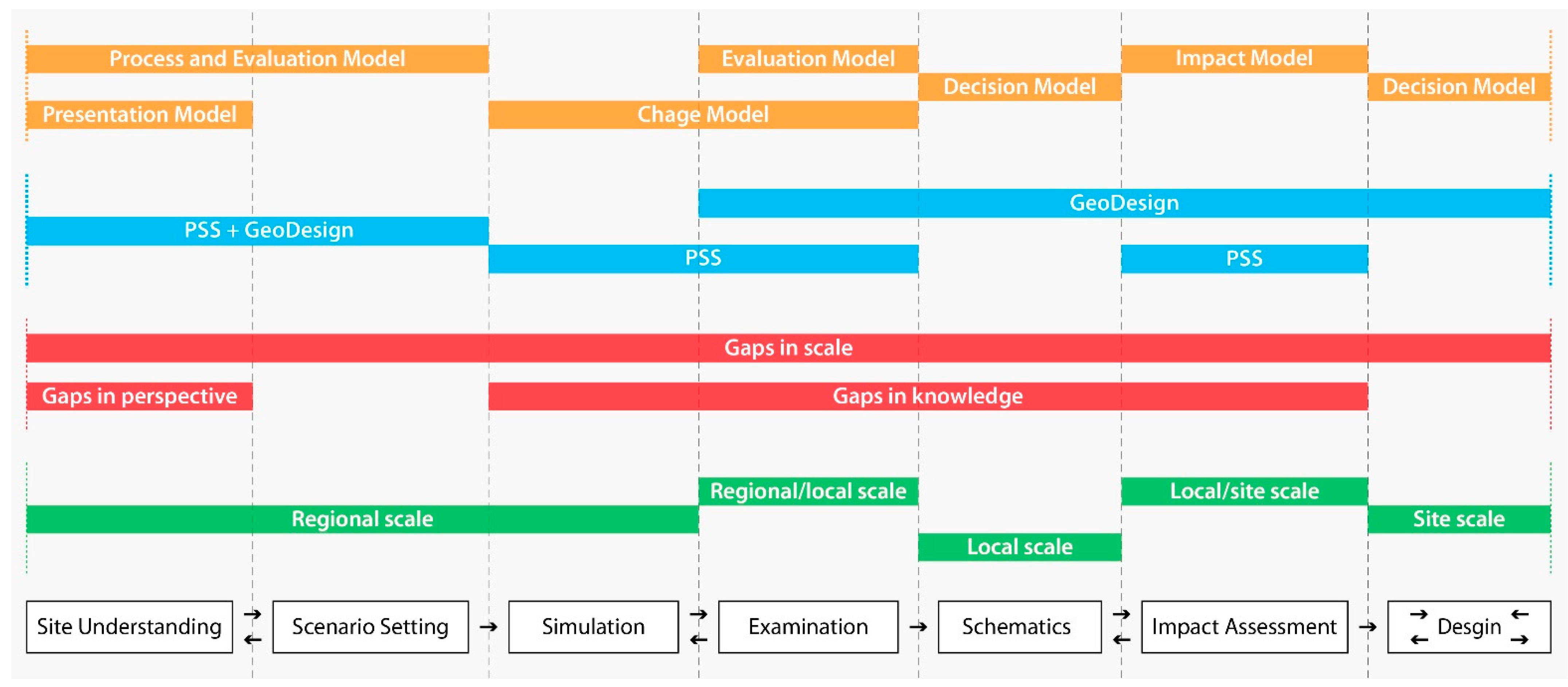
2. Science and Physical Design Gaps

We argue that landscape architecture stands to benefit from opening itself up to evidence-based methods which are more suitable for dealing with the multiscale and long-term problems presently facing designers. In this section, we identify the gaps between science and physical design which present obstacles to integrating the latter into the former. Based on an extensive literature review, we identified three such gaps between science and physical design: (1) gaps in perception, (2) gaps in scale, and (3) gaps in knowledge.

2.1. Gaps in Perception

Historically, landscape designs have largely been based on aesthetic, political, and theoretical perceptions [5,10]. Some of the literature on landscape design reinforces this viewpoint, asserting that aesthetic values should be more emphasized in landscape architecture [46,47]. In this sense, a landscape is perceived as a “canvas” where designers illustrate their ideas of problem-solving in a graphical and artistic way [48]. Howett [49], for example, defines landscape architecture as “making a place of art”.
On the flip side, the word “landscape” has quite a different connotation to the more science-oriented field of ecology. Turner and Gardner [50], for example, define a landscape as “an area that is spatially heterogeneous in at least one factor of interest”. Pickett and Cadenasso [51] interpret the term as “an abstraction representing spatial heterogeneity at any scale”. Although there are variations in definitions, scientific fields generally use “landscape” to refer to a spatially heterogeneous area to be investigated and examined.
This definitional gap helps create an obvious dichotomy between science and design in approaches to problem solving. Milburn and Brown [10] note that designers may pursue more visual and subjective approaches reflecting their backgrounds or experiences, whereas scientists focus more on analytic bases where hypotheses are tested and validated. In other words, for the same urban issues, the way scientists explore solutions can be quite different from the way that designers do. For example, for urban heat island (UHI) issues, general scientific approaches include an examination of spatiotemporal relations among anthropogenic variables to suggest long-term UHI management strategies [52,53]. However, landscape designers may seek more direct and physical solutions, such as green infrastructure designs, where we can expect immediate effects without time-lag. These competing perceptions of problems and their optimal solutions form what we call “perception gaps” between science and physical design. Such gaps pose challenges to communicating clearly and establishing an agreed-upon strategy to achieve resilience.

2.2. Gaps in Scale

Another important difference between science and design is the scale at which they operate. Steinitz [30] notes that most designers learn through projects executed at small and simple scales, whereas most scientists begin with large scales when seeking to understand long-term processes. Landscape design generally explores the scales that humans can directly perceive, and its decisions are normally made at a local or finer level [45,54]. However, for science, an exploration of landscapes in terms of their “spatial heterogeneity” is usually conducted beyond the relatively small scales common to design. Of course, it must be said that urban systems do not obey neat scale boundaries but instead are composed of highly diverse components operating at multiple scales with interactions that have no absolute boundaries [5,45].
Therefore, in order to foster landscape design for urban resilience, it is important for designers to move beyond focusing on a ”human scale” and open up to multiscale approaches that can connect long-term and large-scale understanding to short/medium-term and smaller-scale visions. Physical innovations on the ground emerge from design [45]. However, employing science is fundamental to understand, measure, and predict human–environment systems [23,55]. There is a pressing need to cross different scales [14,30,55]. The literature seems to almost unambiguously suggest that the linkages across different scales should be significantly taken into consideration when designing for the central goal of resilience.

2.3. Gaps in Knowledge

It should go without saying that designers cannot embrace concepts or approaches with no measure of familiarity. In other words, they must first understand scientific knowledge in order to integrate said knowledge into their individual physical designs [24]. However, given the breadth and scale of scientific knowledge, it can be difficult for designers to “come to grips” with the relatively arcane practices necessary to understand complex interactions in urban systems. These practices, which include simulation modeling, engineering calculations, and statistical evaluation, are not necessarily techniques with which designers are highly comfortable. The knowledge gaps between scientists and designers have hampered the translation of research evidence into useful and usable materials for design [21,30,56].
Some scholars have begun to realize the insufficient knowledge of traditional design practices and acknowledged the necessity of marrying analytical evidence and the design creation process (e.g., through drawing) [10,57]. To date, a wide array of practices aiming to create more resilient designs have been attempted [15,21,25,27]. However, some designers have had difficulties in engaging with the descriptive information or have ended up excluding quantitative steps in their design decisions [21,25]. For instance, in their collaboration with landscape designers, Backhouse et al. [25] noted that knowledge employed by the designers consisted of vague ideas with a lack of precise information (e.g., “Trees soak up water”). Although several means of bridging the knowledge gaps were attempted, such as a lower use of scientific terminology and the presentation of modeling results in a graphic manner [21,58], the gaps themselves remained stubbornly persistent.

2.4. Connecting Geodesign and PSS Technologies

Geodesign and PSSs have much in common, especially in terms of their major aims. Both seek to enable practitioners to make advanced decisions while forecasting possible futures and assessing their real-time impacts [30,59]. Flaxman [60] defines Geodesign as “a design and planning method which tightly couples the creation of a design proposal with impact simulations”. Eikelboom et al. [33] mention that Geodesign, combining design and analysis, leads to quantitative decision support. Comparably, Brail [37] describes the PSS as a system that consists of computer-based simulation models and visualization tools within geographic information systems (GIS). According to Pan and Deal [61], a good PSS is a system where the modeling analysis is successfully infused into the decision making in an understandable way.
Both Geodesign and PSSs aim to transparently share integrative information among stakeholders from different disciplines [62,63], although the former focuses on a collaborative process, while the latter refers more to a technical system. We emphasize that both are committed to supporting more robust decision making to solve complex urban issues by utilizing simulation results and visualizing spatial information for users spanning multiple disciplines.
Campagna et al. [62] note that Geodesign and PSSs can be complementary to each other. Geodesign is a process that promotes a smooth collaboration with researchers to produce evidence-based designs by using geospatial technologies [34,64]. PSSs are advanced modeling systems that can add more scientific as well as communicative values to decision making. PSSs help assess the potential impacts of multiple scenarios in a robust way and communicate highly complex computational outcomes with non-experts (e.g., stakeholders) [65]. Similarly, Geodesign can play an excellent complementary role in addressing some of the shortcomings of PSSs that have been pointed out in the literature. For example, some have questioned the uncertainty of the PSS’s effectiveness in practice [38] and high degree of complexity for use [66]. PSSs can help make the design outcomes that are produced through the Geodesign process more scientifically reliable. The computational modeling equipped in the PSS, with its attendant validation, calibration procedures, and high usability can lead designers into deliverables that are built on a set of quantifiable, testable, and (scientifically) valid evidence.

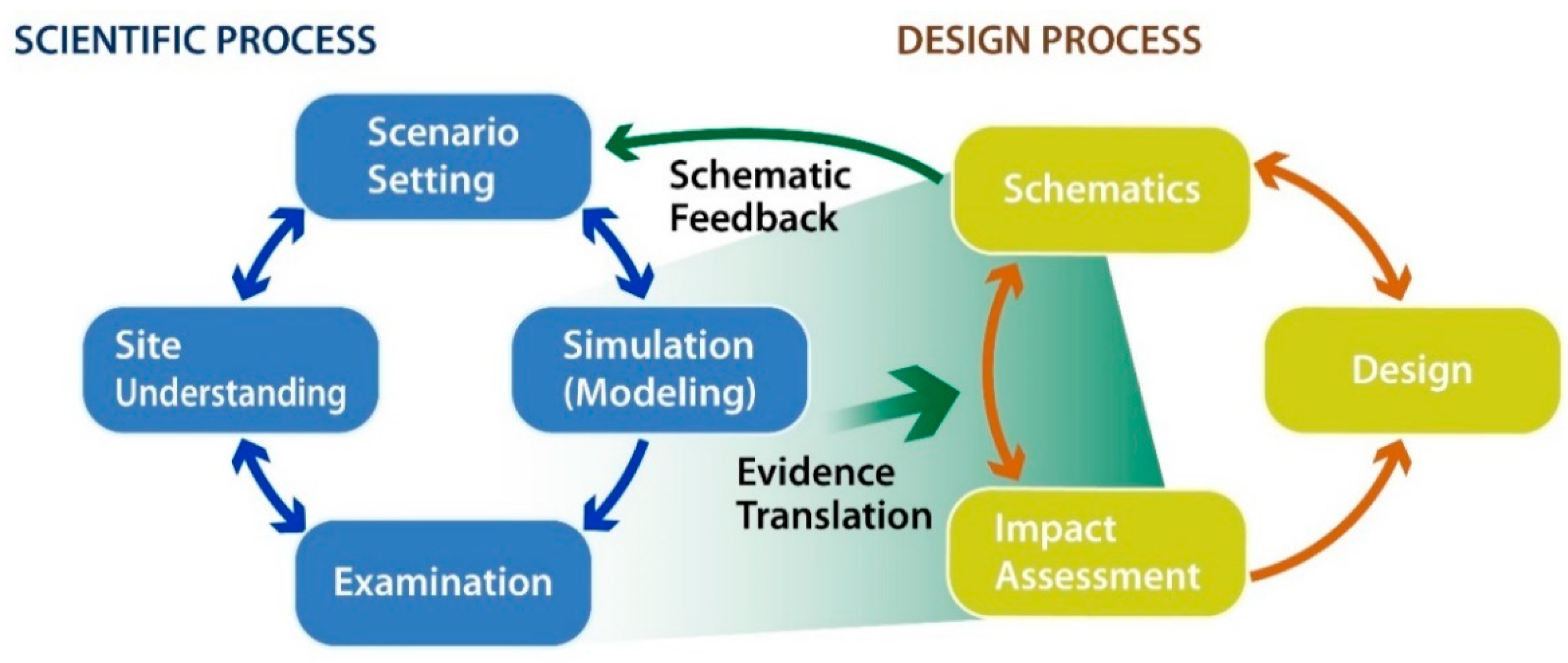
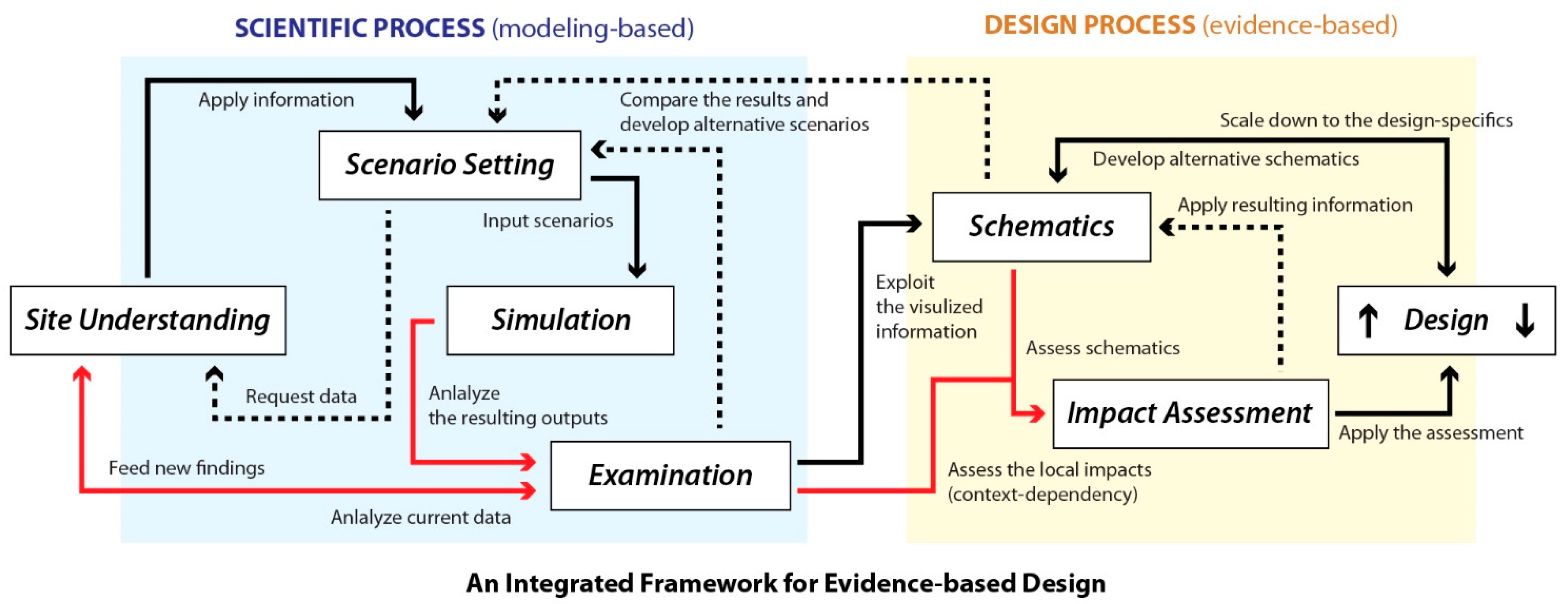
3. An Integrated, Iterative, and Dynamic Framework

We propose a framework for an alternative process of cross-disciplinary planning and design. As a potential PSS, the framework aims to promote the active engagement of designers in smart-city applications, allowing for efficient data management, high accessibility, and modeling localization and contextualization [61,67]. As a scenario-driven process, the framework aims to guide those in charge of design decisions to more strategic responses to multivariate and multistate urban resilience issues. Additionally, as an evidence-based process, it also aims at promoting the successful use of complex and multiscale scientific understanding in design creations. In this way, our framework attempts to bridge the three gaps that have been identified above.
The framework is composed of seven steps within circular chains where the output of each step feeds another step in the loop (Figure 1). The seven steps help to cope with the complexity of urban systems by spatiotemporally projecting scenario-based futures based on a site understanding, assessing the impacts of these potential futures on a given region, and translating the resulting outcomes into design languages. This is accomplished through a back-and-forth feedback system that enhances the collaboration between scientists and designers. In other words, the framework is an integrative design creation process in which general and specific data are analyzed and understood, communally agreed scenarios are established and applied, new ideas are acquired and tested, and designs are developed. The framework is designed to amalgamate science (regional and quantitative modeling analyses) and design (local/site-specific drawing creations).
A specific process is illustrated in Figure 2. The blue box depicts scientific steps that analyze/examine sites, project potential futures, validate the results, and generate useful and usable information. At a regional scale, the framework starts with Site Understanding that requires initial data collection and analysis and determines goals and issues based on the acquired information. In this step, the actors (cross-disciplinary teams) understand a landscape as a spatial system characterized by heterogeneous patches and investigate its underlying, evolving states within a perspective of science.
Once the information is synthesized and the site is better understood, the actors proceed to the Scenario Setting, in which they, with differing viewpoints, produce a set of alternative scenarios that invite possible futures into the process. Each proposed scenario is then assessed by simulating some of the potential futures (at the Simulation step), quantitatively analyzing them (at the Examination step), and visualizing the resulting spatiotemporal outcomes.
This study suggests utilizing computational simulation models built in PSSs, where multiple factors are computed simultaneously to project potential consequences under different scenario settings and, most importantly, where the actors easily utilize the advanced geospatial technologies within an accessible platform. Simulation and Examination are critical in the framework because they help find new ideas that might not be found through mere data collection or mapping processes. Note that the four steps are repeated iteratively and interactively, as described in Figure 2.
To begin with the design process (the yellow box in Figure 2) at a local or neighborhood scale, we suggest a Schematic step to translate the resulting information at a large scale into deliverable physical drawings. The type of schematics can vary depending on the projects, but this step requires creating outlines of design ideas for each scenario based on the information generated from the scientific processes (steps of Simulation and Examination). The schematic design ideas are then tested by Impact Assessment. This step assesses the possible impacts of the design decisions on the surrounding context and allows for feedback to revise and compare the scenarios. Once a set of multiple schematics are assessed and revised, design specifics are created in a traditional way where a landscape is understood as a “canvas” for the design creation. Note that creating design specifics also requires iterative revisions until the actors reach an agreement.
The strengths of this framework include the way it engages designers in regional science and leads them into evidence-based designs; the way it incorporates the existing Geodesign framework in conjunction with the PSS, which support cross-disciplinary collaboration; and the way it addresses the three gaps in perspectives, scales, and knowledge between science and design. Figure 3 provides a comprehensive overview of the proposed framework. We stress the necessity of scientific approaches, which are objective, analytic, and testable, for designers to deal with uncertainty in complex urban systems evolving at varying scales.

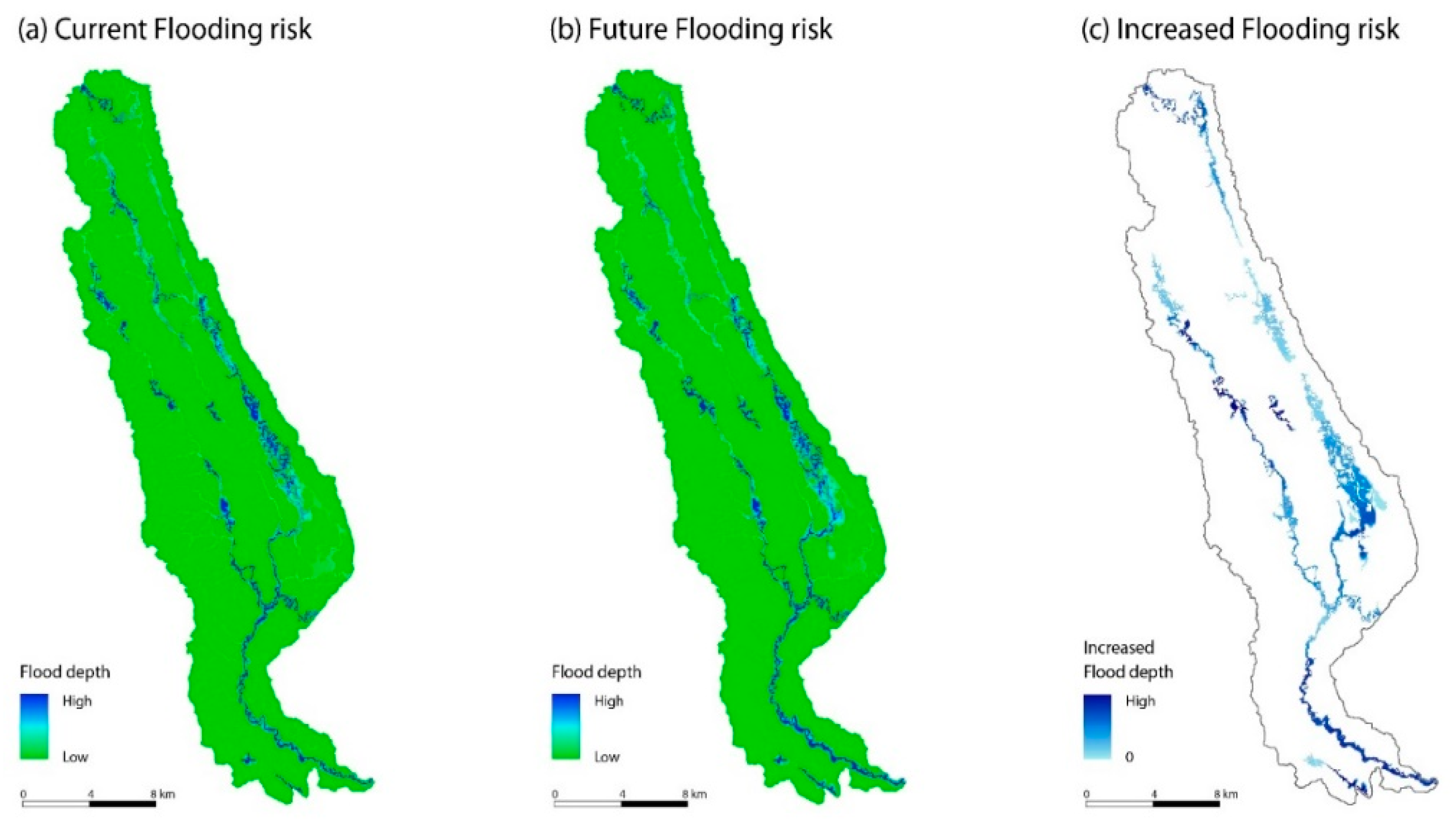
4. Application: A Pilot Study of Sociohydrology Simulation in Chicago

Building on the framework, we conducted a pilot empirical study. This pilot study spatially assessed how land-use change (LUC) affects future runoff risks in Chicago in terms of flood depth. It sought to deliver the useful information for design that can be generated through Simulation and Examination. Additionally, as an empirical study, we addressed the following three questions: (1) How does LUC in a lakeside city affect the risk of associated flooding? (2) To what extent can flooding be expected under different growth scenarios? (3) Which factors that are usable in design can explain the flooding risks?

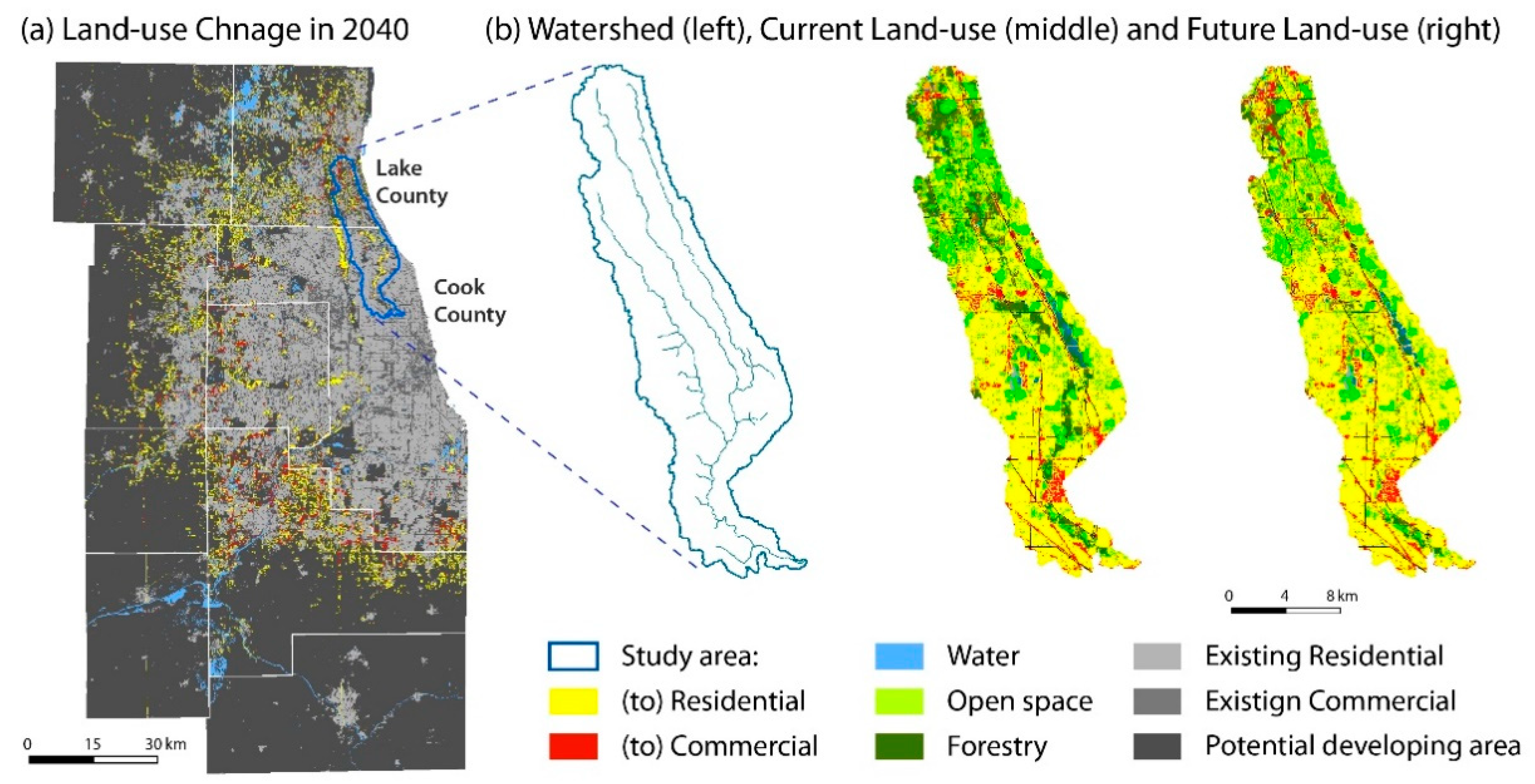
4.1. Pilot Study Background

The Chicago metropolitan area is a low-lying lakeside community that is representative of the uncertainties and challenges in stormwater planning and design. Lake Michigan provides pivotal services in support of the city both environmentally and socioeconomically. The combination of exponential urbanization, poor infrastructure, and increasing rainfall is the root of severe urban flooding, despite costly stormwater management and green infrastructure plans. Common rainfall events lead to flooding and sewage overflows, driving water-borne pollution into Lake Michigan, severely degrading its urban and hydrological ecosystems. This makes it crucial for city stakeholders, planners, and designers to understand the sociohydrological system, specifically requiring the management of potential runoff in association with LUC.

4.2. Model Description

To help understand the sociohydrology of Chicago, we loosely coupled two spatially explicit models, the Landuse Evolution and Impact Assessment Model (LEAM) and the Gridded Surface/Subsurface Hydrologic Analysis mode (GSSHA). LEAM is a cloud-based land-use simulation model built in a PSS, available at http://www.leam.uiuc.edu (accessed on 06 February 2021) (Figure 4). The model estimates future land development by explicitly quantifying interactions between a wide array of biophysical (e.g., geography and water/green space) and socioeconomic (e.g., population and employment) factors. Based on the overriding assumption that the location of future development is determined by local attractors, LEAM generates sequential land-use change maps at a fine scale (30 m × 30 m), answering “what-if” questions and further “so-what” questions. A detailed technical description can be found in Deal et al. [68].
GSSHA is a grid-based, fully distributed model. We used GSSHA, since it has the ability to simulate hydrological features at a fine scale with reasonable accuracy [69]. GSSHA is also known for its comprehensive abilities, which make it applicable to long-term simulation involving LUC [70,71]. Since the physical attributes of land-use, topography, and soil are greatly determinant factors in hydrological responses, GSSHA’s ability to allow the input of spatial data sets at a fine scale makes it a better performer than other lumped models, especially for the urban environment [69,72].

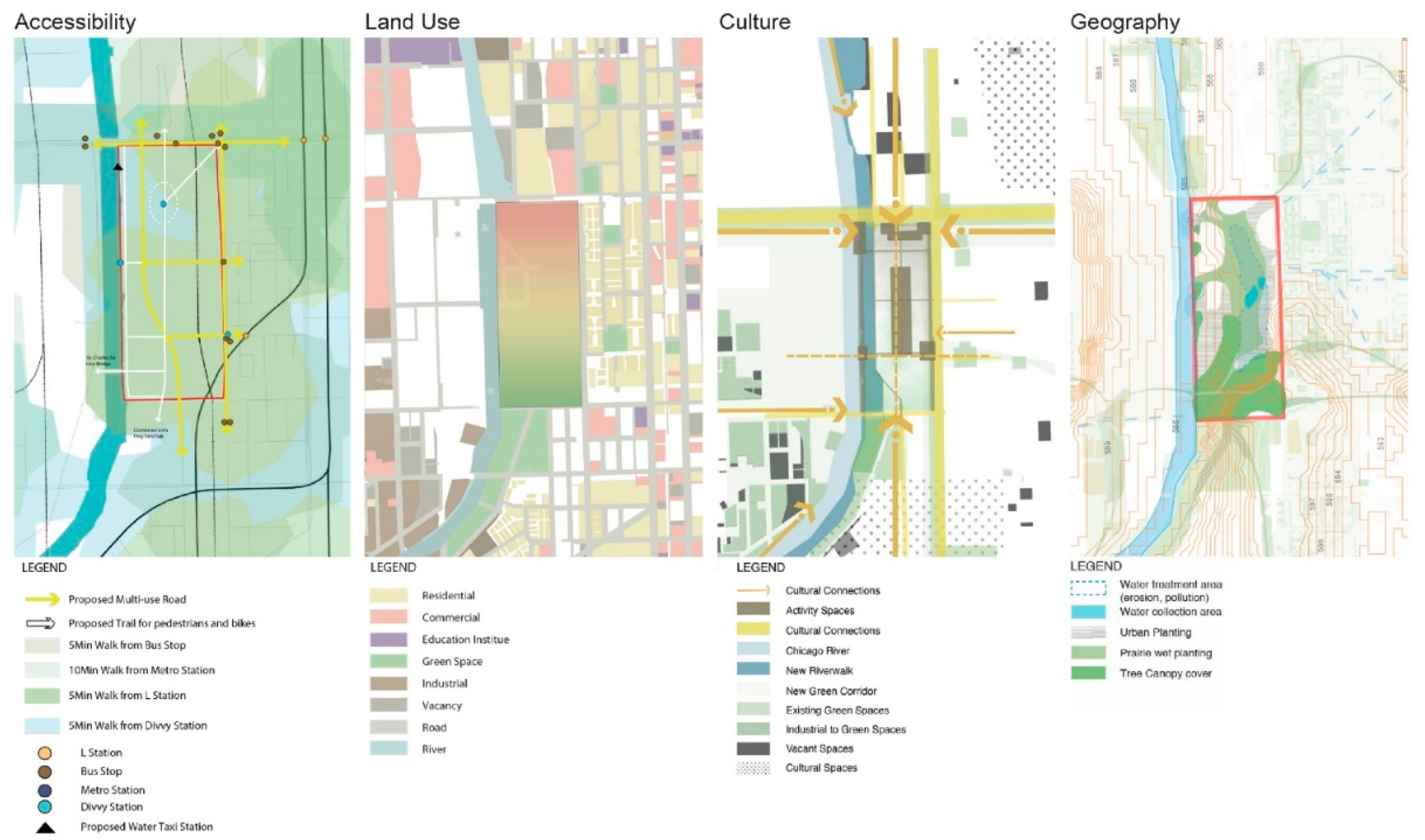
4.3. Process of the Pilot Study

The future LUC for the Chicago region was projected by LEAM (Figure 5). This pilot study selected a portion of the North Branch Chicago River Watershed as the study area (263.74 km2) where LEAM projects noticeable LUC (Figure 5b). We loosely synthesized LEAM with GSSHA. A current land-use map and a projected land-use map from LEAM, respectively, were fed into GSSHA, and GSSHA computed two outcomes accounting for the hydrological impacts of LUC. Figure 6 displays where surface water is accumulated and to what extent runoff risks would be enlarged in the future.

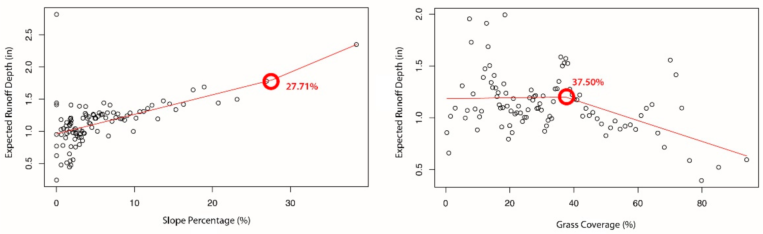
4.4. Assessment with Design Factors

The maps produced, displayed in Figure 6, can deliver useful, spatially explicit information, including distributions of potential runoff spots where designers need to pay special attention to ensure appropriate long-term stormwater management. In this case, the GSSHA model was run controlling for precipitation so that the maps displayed the impacts of Chicago’s growth (LUC) on local hydrology. More specifically, in Figure 6, darker blues indicate areas that are likely to be more vulnerable to runoff in 2040 due to significant land conversions that are displayed in Figure 5.
However, not all information from the model can be appreciated through a single graphical summary. We argue that more information can be revealed through some of the quantitative analyses. Such underlying information should be delivered to and utilized by designers in the form of understandable language in order to promote resilient designs.
To this end, we employed three quantitative methods in which the analytic results can be displayed and translated graphically, and results can deliver useful information of “what to prioritize” and “what to expect”. For the analyses, we selected four design factors that are physically manipulatable in practice, including surface imperviousness, slope percentage, and types of vegetation, based on the hydrology literature and stormwater projects [26,73,74]. Note that in selecting the design variables, we intentionally excluded variables that much of hydrology research indicates are detrimental contributors to runoff, such as rainfall, Leaf Area Index (LAI), and evapotranspiration [75]. These factors were not selected because either they were impractical to design or not familiar to designers.

4.4.1. What to Prioritize: Boosted Regression Trees

The boosted regression trees (BRT) method is a relatively new tree-based modeling approach to capture complex nonlinear relationships. The method is known as a superior alternative to traditional modeling [76]. BRT enumerates relative importance between predictor variables based on the number of times that variables are selected to fit models in an iterative process. The relative influences on runoff depth between the selected design variables are shown in Figure 7. These measures of relative influence offer designers information on which of the four design variables is most important to prioritize to ensure resilience within the study area.
The finding shows that grassland density is a primary contributor to flood depth (44.90% of the importance), which implies that designers should prioritize increasing grass coverage over the other design factors considered to manage the runoff in the study area. The runoff also can also be well managed by physically reforming the lands (27.68%) and replacing the impervious pavements with pervious ones (15.44%).

4.4.2. What to Expect: Piecewise Linear Regression

With regard to the concepts of resilience, identifying critical thresholds that cause abrupt changes in the response variables of ecological processes is crucial. Once the (urban) ecosystem regime crosses over a threshold, it is difficult for it to return stably to its original state(s). Changes in the system regimes may have “breakpoints” where they start responding differently to the disturbances. These “breakpoints” can be spotted if processes are examined over time or with other associated variables. Piecewise linear regression (PLR) models are effective in identifying and estimating the thresholds. PLR is suitable for the examination of ecological systems, especially when different (non)linear relationships are observed for a range of different explanatory variables, and either a single linear or nonlinear model is not appropriate [77,78]. The method has been widely applied to various ecological studies to assess the systems’ capacity and their “breakpoints”. For example, concentrations of total phosphorus increase the risk of algae blooms neither gradually nor smoothly over time, forming nonlinear responses [79].
Our PLR results identify thresholds of the selected design factors at which runoff depth in the study area dramatically changes (Figure 8). The design variables were sorted, broken into 100 equal-sized quantiles, and fed into a PLR model to calculate the expected runoff depth of the corresponding cells for each quantile.
This provides direct information with designers as to “what to expect” pertaining to resilient stormwater designs. The slope percentage largely shows a positive relation with the runoff depth, but we can expect an abrupt increase in runoff when the slope percentage is over 27.71% in the given area. Additionally, we can find a threshold where grass coverage has an effect on runoff control, describing the minimum coverage ratio (%) of the grass area to abate runoff. This quantitative analysis provides practically “usable” information that cannot be revealed on the surface of the spatial maps (Figure 6). This in-depth analytic information can be useful in creating stormwater green infrastructure designs as well as managing existing infrastructures in the consideration of resilience.

5. Discussion and Conclusions

5.1. Discussion

In a typical schematic design phase, designers must consider a seemingly infinite number of competing objectives when considering a project. As a “real world” schematic design involves responding not only to the hydrology as noted above but also (for example) diversity, health, energy, social welfare, safety, sustainability, and accessibility. It may not be suitable to offer a complete design based on scientific information alone. We emphasize, however, that the results provide highly useful and usable information with regard to “where to pay attention” (Figure 6), “what to prioritize” (Figure 7), and “what to expect” (Figure 8). Figure 9 offers some examples of student design projects which utilize the information provided herein to address a site in Chicago.
In addition, the results can be shared in a web-based platform in support of collaboration within PSSs, and in turn, to be used for generating alternative scenarios (Figure 4) that are useful for generating design responses. For example, areas in which the slope exceeds a threshold could be assigned as a “no growth zone” in a new scenario to alleviate the future runoff risk. This greatly affects potential design solutions.
In this work, we tested our framework by employing scientific methods for a larger area, converting the results into usable design components for a smaller area, and applying them to systemic design thinking. Our results suggest several design related ideas: (1) complex modeling systems can effectively be utilized in design processes; (2) quantitative analytic results can be usefully translated into a graphically understandable design language; and, more importantly, (3) scientific evidence can lead to more resilient design ideas.
Among the strengths of our framework is its replicability and flexibility, which allow various quantitative methods to be applied to the framework in support of planning and design decisions. For example, by employing a Multiple-Criteria Decision Analysis (MCDA), the future suitability of green infrastructures or renewable energy development (Site Understanding) under different scenarios (Scenario Setting) can be projected (Simulation), analyzed, and assessed with the current data (Examination and feedbacks to Site Understanding). Then, the statistical and spatial outcomes can be produced within a PSS in an understandable graphic manner (Impact Assessment and sShematic) and be used for the creation of several design alternatives at a smaller scale (design and feedbacks to Schematic).
This framework is intended to benefit two groups. First, for planners and scientists, especially whose research focuses on coupled human and environmental systems, the framework invites them to observe the physical applications of their findings that move beyond the boundaries of regional studies. Second, for designers and practitioners, it provides opportunities to build up their ideas with objective rationales that can play the role of a solid basis.
While the theoretical discussion and the analytic pilot study suggest that the proposed framework can provide a significant advance on state of the art in bridging regional studies with practical designs, future research is needed to validate its applicability and practicality across a wider set of possible problems. There are at least four questions that must be answered: First, can more complex scientific methods, such as a tightly coupled modeling system (a computational complex tool) and its calibration process, be translated into understandable design languages? Second, what collaborative contexts or environments are the necessary conditions for the framework to work successfully? Third, what other regional studies (e.g., the GIS-based MCDA mentioned above) can be applied to the framework? Fourth, focusing on the hydrological study, what other design factors that are usable in practice should be considered with respect to the contemporary stormwater designs? Significant work will be needed to develop perfect communication tools between scientists and designers.
The increasing tendency of contemporary landscape architecture to mix with complex urban systems requires more sophisticated, cross-disciplinarily solutions than ever before [10]. Although a wide array of experiments have been attempted, and a collaborative concept of Geodesign that promotes cross-disciplinary work is on the rise, a framework that articulates a series of procedures where empirical research is constructively infused with design has yet to be established. Designers still encounter difficulties in leveraging science and operationalizing evidence-based design. Landscape architecture—the field that explores the natural and built environment in-depth while integrating nature, design, and science [20]—has a responsibility to embrace a variety of knowledge produced outside of its domains, such as engineering, ecology, economics, and sociology.

5.2. Conclusions

Traditional landscape design that relies on designer creativity, subjective decisions, experiences, and artistic sense is an important and useful method of problem solving. This paper does not seek to replace the valuable skills garnered by designers with computational programs. On the contrary, our work seeks to inform designers so that they can best utilize their traditional creative processes while ensuring urban resiliency with evidence-based strategies.
This paper argues that in order for landscape architecture to effectively engage complex systems in resilient ways, it is necessary to bring science into the realm of physical and practical design. To this aim, we propose a framework that integrates analytic research (i.e., modeling and examination) and design creation (i.e., place-making) with processes that incorporate feedback to help adaptively achieve urban resilience. We base this framework on theories supporting concepts of Geodesign and Planning Support Systems (PSSs). We tested the suggested framework by conducting a pilot study using a coupled sociohydrological model. Design factors were examined to discern how the modeled analytic outcomes can be translated into useful information for landscape design. This work supports the notion that resilient solutions would benefit from a navigable bridge between science and landscape design.
Strategies for adapting to climate change and urban growth require a new systemic understanding of the complex interactions in coupled human–environmental systems to avoid unfavorable consequences that vary according to place and scales. This suggests that the creation of site design (physical change) must be joined with systemic approaches that are objective, reasonable, and testable to sensibly respond to the dynamic mechanisms of complex systems. However, at the same time, it should be recognized that the optimal approaches depend on (site-)specific conditions [16].
In this regard, we hope that this paper will encourage more scholars in the fields of landscape architecture to integrate systemic approaches with design research and practices. In other words, we hope that this paper will make contributions in landscape theories and practices for achieving resilience. Based on Papadimitriou’s complexity classification [80], the pilot study shows that the framework can be used to examine structural (land-use changes) and functional (runoff management) landscape complexity and incorporates qualitative values for site-specific design. This example is limited by its omission of more qualitative variables. In reality, such variables would require attention to ensure any solution addressed social and cultural complexity. Acquisition subjective data (for example, through Public Participation Geographic Information Systems [81]) at the Site Understanding stage could help in this regard.
This study suggests that designing for resilience should amalgamate problem solving to include both the physical “canvas” and a systems approach. The framework suggests that physical changes should be tightly incorporated with validated information of past (calibration), present (examination), and future (simulation) conditions at multiple scales. These methodical analyses should be presented in understandable and accessible ways for designers and design practitioners
We believe that this framework can be leveraged to improve the efficiency of cross-disciplinary collaboration. We further hope that the framework will flexibly evolve into a wide array of adaptations that use multiscale empirical evidence for design studies and projects with varying purposes.
The critical implications of this paper include the introduction of a framework that can function operationally as a system, methodologically as science, and practically in design. More importantly, this paper argues that taking the steps toward more objective design processes supported by scientific information is crucial for the fields of landscape architecture and that such information should be accessible to designers. This true integration will help designers to more strategically and reflexively respond to uncertainty in urban systems and to progressively aim for resiliency in the built environment.

Author Contributions

Conceptualization, Y.K. and B.D.; methodology, Y.K.; analysis and visualization, Y.K.; data curation, Y.K.; writing—original draft preparation, Y.K.; writing—review and editing, Y.K., B.D. and G.M.; supervision, B.D.; funding acquisition, Y.K. and B.D. All authors have read and agreed to the published version of the manuscript.

Funding

This research was funded in part under the provisions of section 104 of the Water Resources Research Act annual base grants (104b) program distributed through the Illinois Water Resources Center and United States Geological Survey.

Institutional Review Board Statement

Not applicable.

Informed Consent Statement

Not applicable.

Conflicts of Interest

The authors declare no conflict of interest.

References

  1. Keane, R.E.; Loehman, R.A.; Holsinger, L.M.; Falk, D.A.; Higuera, P.; Hood, S.M.; Hessburg, P.F. Use of landscape simulation modeling to quantify resilience for ecological applications. Ecosphere 2018, 9, e02414. [Google Scholar] [CrossRef]
  2. Rasoulkhani, K.; Mostafavi, A. Resilience as an emergent property of human-infrastructure dynamics: A multi-agent simulation model for characterizing regime shifts and tipping point behaviors in infrastructure systems. PLoS ONE 2018, 13, e0207674. [Google Scholar] [CrossRef] [PubMed] [Green Version]
  3. Deal, B.; Pan, H.; Pallathucheril, V.; Fulton, G. Urban Resilience and Planning Support Systems: The Need for Sentience. J. Urban Technol. 2017, 24, 29–45. [Google Scholar] [CrossRef]
  4. Holling, C.S. Resilience and Stability of Ecological Systems. Annu. Rev. Ecol. Syst. 1973, 4, 1. [Google Scholar] [CrossRef] [Green Version]
  5. Alberti, M. Simulation and Design of Hybrid Human-Natural-Technological Systems. Technol. Archit. Des. 2017, 1, 135–139. [Google Scholar] [CrossRef]
  6. Deal, B. Ecological urban dynamics: The convergence of spatial modelling and sustainability. Build. Res. Inf. 2001, 29, 381–393. [Google Scholar] [CrossRef]
  7. Brand, F.S.; Jax, K. Focusing the Meaning(s) of Resilience: Resilience as a Descriptive Concept and a Boundary Object. Ecol. Soc. 2007, 12, 23. [Google Scholar] [CrossRef] [Green Version]
  8. Woodward, J.H. Envisioning Resilience in Volatile Los Angeles Landscapes. Landsc. J. 2008, 27, 97–113. [Google Scholar] [CrossRef]
  9. Levin, S.A. Ecosystems and the Biosphere as Complex Adaptive Systems. Ecosystems 1998, 1, 431–436. [Google Scholar] [CrossRef]
  10. Milburn, L.-A.S.; Brown, R.D. The relationship between research and design in landscape architecture. Landsc. Urban Plan. 2003, 64, 47–66. [Google Scholar] [CrossRef] [Green Version]
  11. Pan, H.; Deal, B.; Destouni, G.; Zhang, Y.; Kalantari, Z. Sociohydrology modeling for complex urban environments in support of integrated land and water resource management practices. Land Degrad. Dev. 2018, 29, 3639–3652. [Google Scholar] [CrossRef] [Green Version]
  12. Alberti, M.; Marzluff, J.M. Ecological resilience in urban ecosystems: Linking urban patterns to human and ecological functions. Urban Ecosyst. 2004, 7, 241–265. [Google Scholar] [CrossRef]
  13. Pickett, S.T.A.; Cadenasso, M.L. Linking ecological and built components of urban mosaics: An open cycle of ecological design. J. Ecol. 2008, 96, 8–12. [Google Scholar] [CrossRef]
  14. Pickett, S.T.A.; Cadenasso, M.L.; Grove, J.M. Resilient cities: Meaning, models, and metaphor for integrating the ecological, socio-economic, and planning realms. Landsc. Urban Plan. 2004, 69, 369–384. [Google Scholar] [CrossRef]
  15. Cerra, J.F. Inland Adaptation: Developing a Studio Model for Climate-adaptive Design as a Framework for Design Practice. Landsc. J. 2016, 35, 37–56. [Google Scholar] [CrossRef]
  16. Alberti, M. Ecological Signatures: The Science of Sustainable Urban Forms. Places 2007, 19, 56–60. [Google Scholar]
  17. Ramaswami, A.; Weible, C.; Main, D.; Heikkila, T.; Siddiki, S.; Duvall, A.; Pattison, A.; Bernard, M. A Social-Ecological-Infrastructural Systems Framework for Interdisciplinary Study of Sustainable City Systems. J. Ind. Ecol. 2012, 16, 801–813. [Google Scholar] [CrossRef] [Green Version]
  18. Arnold, C.L.; Gibbons, C.J. Impervious Surface Coverage: The Emergence of a Key Environmental Indicator. J. Am. Plan. Assoc. 1996, 62, 243–258. [Google Scholar] [CrossRef]
  19. Papadimitriou, F. The Algorithmic Complexity of Landscapes. Landsc. Res. 2012, 37, 591–611. [Google Scholar] [CrossRef]
  20. McHarg, I.L. Design with Nature; Doubleday/Natural History Press: Garden City, NY, USA, 1969. [Google Scholar]
  21. Klemm, W.; Lenzholzer, S.; van den Brink, A. Developing green infrastructure design guidelines for urban climate adaptation. J. Landsc. Archit. 2017, 12, 60–71. [Google Scholar] [CrossRef]
  22. Fu, J.-C.; Jang, J.-H.; Huang, C.-M.; Lin, W.-Y.; Yeh, C.-C. Cross-Analysis of Land and Runoff Variations in Response to Urbanization on Basin, Watershed, and City Scales with/without Green Infrastructures. Water 2018, 10, 106. [Google Scholar] [CrossRef] [Green Version]
  23. Wu, J. Urban ecology and sustainability: The state-of-the-science and future directions. Landsc. Urban Plan. 2014, 125, 209–221. [Google Scholar] [CrossRef]
  24. Chen, Z. The Role of Research in Landscape Architecture Practice. PhD Thesis, Virginia Polytechnic Institute and State University, Blacksburg, VA, USA, 2013. [Google Scholar]
  25. Backhaus, A.; Dam, T.; Jensen, M.B. Stormwater management challenges as revealed through a design experiment with professional landscape architects. Urban Water J. 2012, 9, 29–43. [Google Scholar] [CrossRef]
  26. Saleh, F.; Ramaswamy, V.; Georgas, N.; Blumberg, A.F.; Pullen, J.; Chen, S.; Holt, T.; Schmidt, J. An integrated weather–hydrologic–coastal–stormwater framework to model urban-coastal interactions: City of Hoboken application. J. Flood Risk Manag. 2019, 12, e12477. [Google Scholar] [CrossRef]
  27. Frazier, T.G.; Thompson, C.M.; Dezzani, R.J.; Butsick, D. Spatial and temporal quantification of resilience at the community scale. Appl. Geogr. 2013, 42, 95–107. [Google Scholar] [CrossRef]
  28. Gibbons, L.; Cloutier, S.; Coseo, P.; Barakat, A. Regenerative Development as an Integrative Paradigm and Methodology for Landscape Sustainability. Sustainability 2018, 10, 1910. [Google Scholar] [CrossRef] [Green Version]
  29. Gu, Y.; Deal, B.; Larsen, L. Geodesign Processes and Ecological Systems Thinking in a Coupled Human-Environment Context: An Integrated Framework for Landscape Architecture. Sustainability 2018, 10, 3306. [Google Scholar] [CrossRef] [Green Version]
  30. Steinitz, C. A Framework for Geodesign: Changing Geography by Design; Esri: Redlands, CA, USA, 2012; ISBN 9781589483330. [Google Scholar]
  31. Marimbaldo, F.J.M.; Manso-Callejo, M.-Á.; Alcarria, R. A Methodological Approach to Using Geodesign in Transmission Line Projects. Sustainability 2018, 10, 2757. [Google Scholar] [CrossRef] [Green Version]
  32. Li, W.; Milburn, L.-A. The evolution of geodesign as a design and planning tool. Landsc. Urban Plan. 2016, 156, 5–8. [Google Scholar] [CrossRef]
  33. Eikelboom, T.; Janssen, R. Comparison of Geodesign Tools to Communicate Stakeholder Values. Group Decis. Negot. 2015, 24, 1065–1087. [Google Scholar] [CrossRef] [Green Version]
  34. Huang, L.; Xiang, W.; Wu, J.; Traxler, C.; Huang, J. Integrating GeoDesign with Landscape Sustainability Science. Sustainability 2019, 11, 833. [Google Scholar] [CrossRef] [Green Version]
  35. Campagna, M.; Di Cesare, E.A.; Cocco, C. Integrating Green-Infrastructures Design in Strategic Spatial Planning with Geodesign. Sustainability 2020, 12, 1820. [Google Scholar] [CrossRef] [Green Version]
  36. Dangermond, J. Geodesign and gis–designing our futures. In Peer Reviewer Proceedings of Digital Landscape Architecture; Anhalt University of Applied Science: Berlin, Germany, 2010; Available online: http://www.kolleg.loel.hs-anhalt.de/landschaftsinformatik/436.html (accessed on 26 March 2020).
  37. Brail, R.K. Planning Support Systems for Cities and Regions; Lincoln Institute of Land Policy: Cambridge, MA, USA, 2008; ISBN 9781558441828. [Google Scholar]
  38. Vonk, G.A. Improving Planning Support: The Use of Planning Support Systems for Spatial Planning. Ph.D. Thesis, Universiteit Utrecht, Utrecht, The Netherlands, 2006. [Google Scholar]
  39. Geertman, S.; Stillwell, J. Planning support systems: An inventory of current practice. Comput. Environ. Urban Syst. 2004, 28, 291–310. [Google Scholar] [CrossRef]
  40. Couclelis, H. “Where has the Future Gone?” Rethinking the Role of Integrated Land-Use Models in Spatial Planning. Environ. Plan. Econ. Space 2005, 37, 1353–1371. [Google Scholar] [CrossRef]
  41. Vonk, G.; Geertman, S.; Schot, P. Bottlenecks Blocking Widespread Usage of Planning Support Systems. Environ. Plan. Econ. Space 2005, 37, 909–924. [Google Scholar] [CrossRef] [Green Version]
  42. Saarloos, D.J.M.; Arentze, T.A.; Borgers, A.W.J.; Timmermans, H.J.P. A multi-agent paradigm as structuring principle for planning support systems. Comput. Environ. Urban Syst. 2008, 32, 29–40. [Google Scholar] [CrossRef]
  43. Te Brömmelstroet, M. Performance of planning support systems: What is it, and how do we report on it? Comput. Environ. Urban Syst. 2013, 41, 299–308. [Google Scholar] [CrossRef]
  44. Pelizaro, C.; Arentze, T.; Timmermans, H. GRAS: A Spatial Decision Support System for Green Space Planning. In Planning Support Systems Best Practice and New Methods; Geertman, S., Stillwell, J., Eds.; Springer: Dordrecht, The Netherlands, 2009; pp. 191–208. [Google Scholar]
  45. Opdam, P.; Luque, S.; Nassauer, J.; Verburg, P.H.; Wu, J. How can landscape ecology contribute to sustainability science? Landsc. Ecol. 2018, 33, 1–7. [Google Scholar] [CrossRef] [Green Version]
  46. van Etteger, R.; Thompson, I.H.; Vicenzotti, V. Aesthetic creation theory and landscape architecture. J. Landsc. Archit. 2016, 11, 80–91. [Google Scholar] [CrossRef]
  47. Kullmann, K. Disciplinary convergence: Landscape architecture and the spatial design disciplines. J. Landsc. Archit. 2016, 11, 30–41. [Google Scholar] [CrossRef] [Green Version]
  48. Gregory, S.A. Design and the design method. In The Design Method; Springer: Boston, MA, USA, 1966; pp. 3–10. [Google Scholar]
  49. Howett, C.M. Landscape Architecture: Making a Place for Art. Places 1985, 2, 52–60. [Google Scholar]
  50. Turner, M.G.; Gardner, R.H. Landscape Ecology in Theory and Practice; Springer: New York, NY, USA, 2015; ISBN 978-1-4939-2793-7. [Google Scholar]
  51. Pickett, S.T.A.; Cadenasso, M.L. Landscape Ecology: Spatial Heterogeneity in Ecological Systems. Science 1995, 269, 331–334. [Google Scholar] [CrossRef]
  52. Kwak, Y.; Park, C.; Deal, B. Discerning the success of sustainable planning: A comparative analysis of urban heat island dynamics in Korean new towns. Sustain. Cities Soc. 2020, 61, 102341. [Google Scholar] [CrossRef]
  53. Rosenzweig, C.; Solecki, W.D.; Parshall, L.; Chopping, M.; Pope, G.; Goldberg, R. Characterizing the urban heat island in current and future climates in New Jersey. Environ. Hazards 2005, 6, 51–62. [Google Scholar] [CrossRef]
  54. Tribot, A.-S.; Deter, J.; Mouquet, N. Integrating the aesthetic value of landscapes and biological diversity. Proc. R. Soc. B Biol. Sci. 2018, 285, 20180971. [Google Scholar] [CrossRef] [PubMed]
  55. Fraser, E.D.G.; Mabee, W.; Slaymaker, O. Mutual vulnerability, mutual dependence: The reflexive relation between human society and the environment. Glob. Environ. Chang. 2003, 13, 137–144. [Google Scholar] [CrossRef]
  56. Beunen, R.; Opdam, P. When landscape planning becomes landscape governance, what happens to the science? Landsc. Urban Plan. 2011, 100, 324–326. [Google Scholar] [CrossRef]
  57. Yu, C.-Y.; Chiang, Y.-C. Designing a Climate-Resilient Environmental Curriculum—A Transdisciplinary Challenge. Sustainability 2017, 10, 77. [Google Scholar] [CrossRef] [Green Version]
  58. Chen, Y.; Samuelson, H.W.; Tong, Z. Integrated design workflow and a new tool for urban rainwater management. J. Environ. Manage. 2016, 180, 45–51. [Google Scholar] [CrossRef] [Green Version]
  59. Wang, H.; Shen, Q.; Tang, B. A Review of Planning Support Systems for Urban Land Use Planning. In Proceedings of the 17th International Symposium on Advancement of Construction Management and Real Estate; Springer: Heidelberg, Germany, 2014; pp. 233–248. [Google Scholar]
  60. Flaxman, M. Geodesign: Fundamental principles and routes forward. In Proceedings of the GeoDesign Summit, Redlands, CA, USA, 6–8 January 2010. [Google Scholar]
  61. Pan, H.; Deal, B. Reporting on the Performance and Usability of Planning Support Systems—Towards a Common Understanding. Appl. Spat. Anal. Policy 2020, 13, 137–159. [Google Scholar] [CrossRef]
  62. Campagna, M.; Di Cesare, E.A.; Matta, A.; Serra, M. Bridging the Gap between Strategic Environmental Assessment and Planning: A Geodesign Perspective. Int. J. E-Plan. Res. 2018, 7, 34–52. [Google Scholar] [CrossRef]
  63. Eikelboom, T.; Janssen, R. Collaborative use of geodesign tools to support decision-making on adaptation to climate change. Mitig. Adapt. Strateg. Glob. Chang. 2017, 22, 247–266. [Google Scholar] [CrossRef] [Green Version]
  64. Muller, B.; Flohr, T. A Geodesign approach to environmental design education: Framing the pedagogy, evaluating the results. Landsc. Urban Plan. 2016, 156, 101–117. [Google Scholar] [CrossRef]
  65. Deal, B.; Pan, H.; Timm, S.; Pallathucheril, V. The role of multidirectional temporal analysis in scenario planning exercises and Planning Support Systems. Comput. Environ. Urban Syst. 2017, 64, 91–102. [Google Scholar] [CrossRef]
  66. Te Brömmelstroet, M.; Schrijnen, P.M. From Planning Support Systems to Mediated Planning Support: A Structured Dialogue to Overcome the Implementation Gap. Environ. Plan. B Plan. Des. 2010, 37, 3–20. [Google Scholar] [CrossRef]
  67. Komninos, N.; Kakderi, C.; Panori, A.; Tsarchopoulos, P. Smart City Planning from an Evolutionary Perspective. J. Urban Technol. 2019, 26, 3–20. [Google Scholar] [CrossRef]
  68. Deal, B.; Pallathucheril, V.G.; Sun, Z.; Terstriep, J.; Hartel, W. LEAM Technical Document: Overview of the LEAM Approach; Dep. Urban Reg. Planning, University of Illinois: Urbana-Champaign, IL, USA, 2005. [Google Scholar]
  69. Downer, C.; Ogden, F. Gridded Surface Subsurface Hydrologic Analysis (GSSHA) User’s Manual; Coastal and Hydraulics Laboratory, Engineer Research and Development Center: Vicksburg, MS, USA, 2006. [Google Scholar]
  70. Downer, C.W.; Ogden, F.L. GSSHA: Model to Simulate Diverse Stream Flow Producing Processes. J. Hydrol. Eng. 2004, 9, 161–174. [Google Scholar] [CrossRef]
  71. Moore, M.F.; Vasconcelos, J.G.; Zech, W.C. Modeling Highway Stormwater Runoff and Groundwater Table Variations with SWMM and GSSHA. J. Hydrol. Eng. 2017, 22, 04017025. [Google Scholar] [CrossRef]
  72. Sharif, H.; Al-Zahrani, M.; Hassan, A. Physically, Fully-Distributed Hydrologic Simulations Driven by GPM Satellite Rainfall over an Urbanizing Arid Catchment in Saudi Arabia. Water 2017, 9, 163. [Google Scholar] [CrossRef]
  73. Yao, L.; Chen, L.; Wei, W. Exploring the Linkage between Urban Flood Risk and Spatial Patterns in Small Urbanized Catchments of Beijing, China. Int. J. Environ. Res. Public Health 2017, 14, 239. [Google Scholar] [CrossRef] [Green Version]
  74. US EPA. Coastal Stormwater Management through Green Infrastructure; U.S. Environmental Protection Agency: Washington, DC, USA, 2014.
  75. Chintalapudi, S.; Sharif, H.O.; Furl, C. High-Resolution, Fully Distributed Hydrologic Event-Based Simulations Over a Large Watershed in Texas. Arab. J. Sci. Eng. 2017, 42, 1341–1357. [Google Scholar] [CrossRef]
  76. Elith, J.; Leathwick, J.R.; Hastie, T. A working guide to boosted regression trees. J. Anim. Ecol. 2008, 77, 802–813. [Google Scholar] [CrossRef] [PubMed]
  77. Boys, C.A.; Robinson, W.; Miller, B.; Pflugrath, B.; Baumgartner, L.J.; Navarro, A.; Brown, R.; Deng, Z. A piecewise regression approach for determining biologically relevant hydraulic thresholds for the protection of fishes at river infrastructure. J. Fish Biol. 2016, 88, 1677–1692. [Google Scholar] [CrossRef] [PubMed]
  78. Ryan, S.E.; Porth, L.S. A Tutorial on the Piecewise Regression Approach Applied to Bedload Transport Data; Department of Agriculture, Forest Service: Fort Collins, CO, USA, 2007.
  79. Watson, S.; McCauley, E.; Downing, J.A. Sigmoid relationships between phosphorus, algal biomass, and algal community structure. Can. J. Fish Aquat. Sci. 1992, 49, 2605–2610. [Google Scholar] [CrossRef]
  80. Papadimitriou, F. Conceptual modelling of landscape complexity. Landsc. Res. 2010, 35, 563–570. [Google Scholar] [CrossRef]
  81. Sowińska-Świerkosz, B.; Michalik-Śnieżek, M.; Soszyński, D.; Kułak, A. In the Search of an Assessment Method for Urban Landscape Objects (ULOs): Tangible and Intangible Values, Public Participation Geographic Information Systems (PPGIS), and Ranking Approach. Land 2020, 9, 502. [Google Scholar] [CrossRef]
Figure 1. A framework for the creation of evidence-based designs. Quantitative outcomes from the research process are translated into usable evidence, and design schematics are fed back to the scenario setting.
Sustainability 13 04666 g001
Figure 2. Specific steps of the framework. Examination, modeling, and translation (to understandable languages) are mainly processed by scientists who understand design and designers who understand science. Red lines indicate quantitative processes that can be joint with the PSS environment. Black lines indicate the general processes for the creation of planning and design, and dotted lines represent processes of feedback/adjustment.
Sustainability 13 04666 g002
Figure 3. Comprehensive coverage of the proposed framework. This represents that the framework is coined with the Steinitz’s Six Models Geodesign Framework (orange). This illustrates where PSS and Geodesign are joined with the processes (blue), how the three gaps between science and design can be bridged (red), and how the framework deals with multiple scales in terms of application (green).
Sustainability 13 04666 g003
Figure 4. A screenshot of a PSS cloud-based platform of LEAM.
Sustainability 13 04666 g004
Figure 5. (a) Land-use change forecast for 2040, and (b) study area: a portion of the North Branch Chicago River Watershed (left), land-use in 2010 (middle), and forecasted land-use (right) of the study area.
Sustainability 13 04666 g005
Figure 6. (a) GSSHA flood depth result for the current 2010 land-use, (b) GSSHA flood depth result for the forecasted 2040 land-use, and (c) vulnerable areas where flood depth is projected to increase—darker blues indicate areas that are likely to be more vulnerable to runoff in 2040.
Sustainability 13 04666 g006
Figure 7. A visual result of boosted regression tree modeling: relative importance (influence) to runoff between the four design factors.
Sustainability 13 04666 g007
Figure 8. A visual result of Piecewise Linear Regression modeling: thresholds of slope percentage (left) and grass coverage (right).
Sustainability 13 04666 g008
Figure 9. Examples of schematic designs. Four images above are the student designs from a graduate landscape design studio class (LA 537) in 2019 at the University of Illinois at Urbana Champaign. The graphics are credited to Cher Wong, Xuejing Li, Yutian Wang, and Xi Liu.
Sustainability 13 04666 g009
Publisher’s Note: MDPI stays neutral with regard to jurisdictional claims in published maps and institutional affiliations.

