Article

Transition and Transformation of a Rural Landscape: Abandonment and Rewilding

1
School of Environmental Sciences, University of Nova Gorica, SI-5000 Nova Gorica, Slovenia
2
Anton Melik Geographical Institute, Research Center of the Slovenian Academy of Sciences and Arts, SI-1000 Ljubljana, Slovenia
3
Institute of Geological Survey, China University of Geosciences (Wuhan), Wuhan 430074, China
*
Author to whom correspondence should be addressed.
retired.
Sustainability 2021, 13(9), 5130; https://doi.org/10.3390/su13095130
Submission received: 15 March 2021 / Revised: 29 April 2021 / Accepted: 30 April 2021 / Published: 4 May 2021

Abstract

:
The concepts of slow environmental change through evolutionary processes associated with ordinary artefacts from Central European rural life as part of biogeographical morphology was studied in Goričko Landscape Park, northeastern Slovenia. The research was based on field observations, including the recording of a former aristocratic dwelling and two small rural farmsteads, all abandoned. An analysis of the extant residual artefacts, their in situ placement and their former utility was undertaken. The value of residual items in ascertaining local perceptions, occupations and utilizations of landscape resources, from various viewpoints, was discussed in relationship to the surrounding landscape. The authors found that the abandoned rural buildings are now utilised as a faunal habitat, and the ruins were reincorporated into the wider landscape. The study sites represent empty places in the process of returning to nature after the retreat of human activities. The research examined the transition and transformation of biodegradable/non-biodegradable components within a rural landscape.

1. Introduction

Landscape is defined as “an area, as perceived by people, whose character is the result of the action and interaction of natural and/or human factors” [1]. Accordingly, landscape is the interaction of people and the environment, and every landscape, not just the outstanding ones, frame people’s lives and define their identity, at local, national and European levels [2]. Therefore, historic natural and cultural features within the landscape can be identified through the cultural meaning features of past human presence and even the ecological remains of past land use.
The majority of European landscapes, particularly rural landscapes, have a cultural origin inextricably linked to agriculture, forestry and livestock [3]. The current socio-economic trends favour land abandonment, industrialisation and conservation policies that support and encourage restoration [4]. As a result, European landscapes have undergone rapid transformation [1]. The marginalization of agriculture and the abandonment of arable land is one of the most important transformations of landscapes in Europe [5]. In many rural areas of Europe, the process of marginalization is of a long duration, and has led to the abandonment of rural settlements and activities [6]. The landscape is transformed into something else, but records the movements and events that pass through it [7]. The different stages of abandonment and post-abandonment sequences reveal complex anthropogenic and natural influences that complicate spatio-temporal concepts of cultural practice within a rural setting [8].
Utility, significance and associations, coupled with generations of experience with familiar landscape features, can be used to capture the ecological and cultural significance of a place in the wider environment. Geographic data with contemporary landscape influences and memories incorporating local experience is fundamental to defining and describing landscape transformation, and can be a good way to synthesise analysis and interpretation.
Although Brook [9] and Given [10] have philosophically explored the complex interaction of biogeographical and cultural elements, this study is possibly the first to attempt an integration of philosophical, socio-cultural and environmental concepts at the landscape level. In this context, a number of concepts have been accepted: ‘transition’ as the slow act of change through evolutionary processes of use, wear, abandonment and decay, and ‘transformation’ as the process of physical change and reintegration of materials into the ecosystem within the landscape setting. As environmental evolution under natural conditions is a slow process of transformation, the distinction between interior and exterior boundaries can become blurred as the exterior overlays the interior through structural collapse, and protected objects can resist decay for a period of time, not in the sense of museum curation, but as succinctly described by DeSilvey [11] as in situ “arrested decay”. The impacts on rural biodiversity due to land use change, aging populations, and demographic shifts may provide an opportunity to improve habitat availability over past species fragmentation, although this remains a topic of debate, particularly with the anthropogenic maintenance of grasslands and low-intensive agriculture [5,12].
Brook [9] perceived that those who manage the land have an intimate knowledge of their landscape as a co-operative creativity over generations. In order to identify the aspects of historical and social values held locally over generations in the Goričko landscape in northeast of Slovenia, cultural meaning elements were identified as evidence of past human presence and ecological evidence of past land use, according to the concept of landscape. The value of residual items in determining the local perceptions, occupations and use of natural and anthropogenic resources is discussed in relation to the Goričko landscape. The transformation from anthropogenic use to an ecological habitat was explored through socio-economic and environmental changes, and the establishment of new relationships as ecological processes unfolded, particularly the complexity of fluid anthropogenic and faunal relationships either ‘in place’, i.e., domestication, such as cattle in a barn, or ‘out of place’, e.g., household-dwelling vermin such as rodents, nesting pine martins and birds [13]. As described by Brook [9], the historical tradition of the landscape can be linked to cultural heritage, and the inhabitants of Goričko value the preservation of traditions and cultural patterns associated with the local landscape [14]. Goričko is a vernacular landscape that has been shaped over millennia by anthropogenic and natural interactions to serve its agricultural purpose. Through this process, one can see in miniature in Goričko the complexity of anthropogenic environments determined by geographic features that have evolved throughout human history.
The research question here aims to explore the intrinsic value of the landscape, including the transformation of dwellings as they transition from anthropogenic use to an ecological habitat and eventually re-enter the environment. This process of creation, use and decay is presented as a cyclical and natural consequence, through material use, occupation, abandonment and reuse. In understanding historical geographies and their relationship to current land use practices, one should remember Darby’s words, “the different elements that make up a landscape do not change at the same rate nor at the same time” [15].

2. Materials and Methods

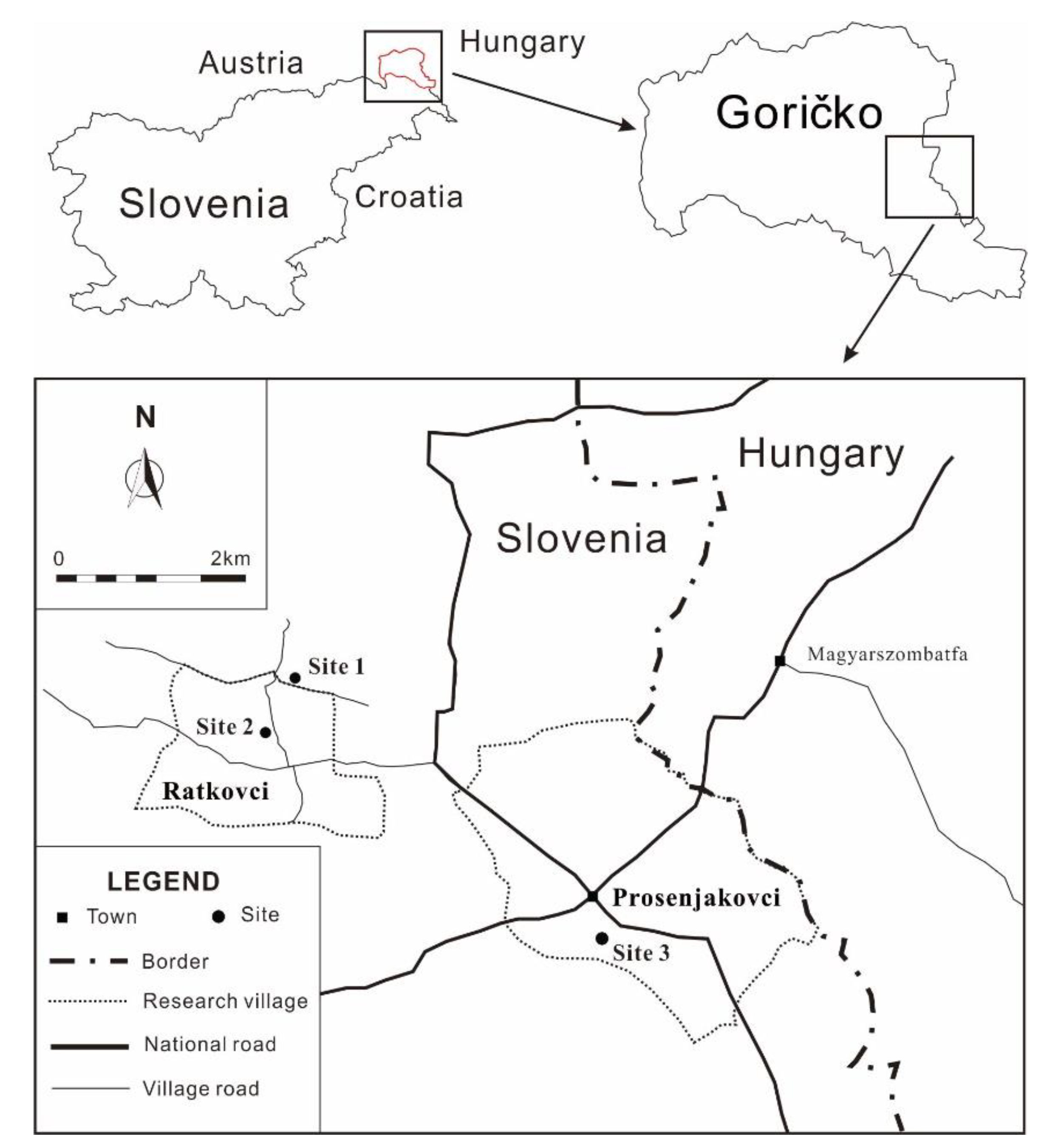
2.1. Study Area and Study Sites

The Goričko Landscape Park was chosen as the study area because it is an example of the landscape characteristics of Central Europe [16,17,18,19,20], an area dominated for many centuries by anthropogenic development for housing, commerce, industry and intensive agriculture, such that the landscape reflects multiple uses, and consequently land use conflicts. Therefore, this typical Central European rural landscape has been formed from several mosaics patterned by the historical and cultural traditions of its inhabitants, local geographical factors and political interventions. The Goričko Landscape Park covers the hilly sector of north-eastern Slovenia, which has developed over a millennium an individual form of land use [14]. In the landscape of Goričko there are seasonally interwoven areas of small orchards, pastures and meadows, vineyards and pumpkin fields fringed by forests, where subsistence agriculture prevails [21]. This landscape is maintained by geopolitical, economic and sociological factors of marginality (i.e., in the Hungarian–Slovenian border region) [22]. In Goričko, most villages are located on hill tops or along ridge lines. The rural architectural style of Goričko, known as ‘Pannonian’, demonstrates domestic construction dominated by the use of abundant local clay, kneaded between timber planks, used as rammed earth walls, abode and field-fired bricks, although hidden beneath layers of plastering and paint [23]. The older homesteads were either one long, narrow building with adjacent out houses, or ‘L’ shaped [24,25]. Some were of red brick construction, while others were a mix of brick and abode. Many barns had an intricate open work pattern for cross ventilation. This is indicative of a long cropping tradition in the region. This vernacular architecture is extant in the Goričko landscape, but it is no longer constructed due to modern municipal planning codes.
Within the study area, three sites representing abandoned buildings in the area were selected by the director of the Goričko Landscape Park. These study sites are located in two villages, Ratkovci (Sites 1 and 2) and Prosenjakovci (Site 3) (Figure 1), within the Municipality of Moravske Toplice, which borders Hungary and is an area known for its ethnic Hungarian communities. In Ratkovci, the small population of 54 [26] is scattered along the valley of the Ratkovski potok stream and the road linking Prosenjakovci with the Križevci villages. The shallow valley is dominated by meadows with fields on gentle, sunny slopes and forests at higher elevations. The agricultural holdings are small, with honey production and dairying being the main economic activities. Most villagers are employed in the Prosenjakovci village [27]. The roadside village of Prosenjakovci, lying in the valley of the Ratkovski potok stream, is a larger, closely settled, bilingual village located near the Slovenian–Hungarian border at a significant road junction [27], with a current population of 163 [26]. The surrounding area is cultivated, the fields are dominated by wheat and corn, and livestock breeding is highly developed; the southern slopes are planted with vineyards and the northern portion is covered by forest [28].
Sites 1 and 2 (Figure 2 and Figure 3, respectively) were representative of numerous abandoned farm dwellings built in the Pannonian style, while Site 3 (the Matzenau Manor) represents a feudal recreational residence of the early 19th century ([29] Figure 4) which, through altered use into a working farm and later being socialised, created an alternative perspective of landscape interaction. Rural buildings in Goričko are oriented in the same direction and they are arranged in a row along one or both sides of the road; however, they do not border it and stand equidistant from it [30]. Visually, there has been a natural continuation from earlier centuries as described by Maučec [31], in whose house description there was usually a courtyard, garden, vegetable garden, well and corn rack. Maučec [31] defined Pannonian houses (Sites 1 and 2) in the Prekmurje region as a result of centuries of development, reflecting historical events, social occasions and anthropogenic endeavour in aspects of material and spiritual culture. The Matzenau Manor (Site 3) was constructed in the first third of the 19th century [32] as a seasonal and hunting lodge set in 150 hectares of park and rural land [29].
The farmstead and barn belonging to Site 1 (Figure 2) are clustered and oriented north–south, with an eastern aspect. The kitchen is the central room, with a brick and tiled fireplace occupying almost the entire length of the southern wall. A single window is located in the center of the west wall, providing a view of the orchard. The southern room is a day room/dining room with simple, rustic furniture and utensils. A large window faces south and a smaller window opens onto the eastern veranda. The northern room is partially below ground level, and has an earthen floor and a small east-facing window. The room was apparently a wine-making and storage cellar. A ladder leads to the attic area above.
The farmstead of Site 2 (Figure 3) consists of three rooms: a centrally located kitchen with a very low doorway, to the south a square room with two windows to the south and one to the east, and a northern cellar/storage or workroom with a very small, light opening without glazing in the eastern wall. All of the floors are of beaten earth with an irregular surface. It has a low gable roof with an attic, which previously had two small north and south windows, the remains of which are in the attic. A veranda runs along the eastern side of the building with roughly carved veranda posts and finer carved roof beams. A lintel light is positioned above the twin-paneled wooden front door. The horizontal wall planks had been filled with abode, a clay-water-straw mixture, and covered thickly with the same material and painted with lime paint. An outside ladder leading to the attic is attached to the south wall. A covered well is located under the veranda roof at the northern end.
Double-panelled wooden doors lead into an entrance hall at Site 3. Six ground floor rooms face the front of the building. At the eastern end of the ground floor is a doorway directly facing the well. A wide central hallway with marble terrazzo flooring runs through the middle of the building, separating the reception rooms from the living quarters [33].

2.2. Data Collection and Analysis

The fieldwork was conducted in order to test for the presence or absence of items considered household artefacts (evidence of former human presence), the intrusion of wildlife into residential buildings abandoned by human inhabitants (ecological evidence of former land use), and the rate of reintegration into the wild environment (transformation from anthropogenic use to an ecological habitat).
Firstly, the three abandoned buildings selected in the Goričko Landscape Park (Sites 1, 2 and 3) were assessed, recorded and described in order to identify aspects of their use within the landscape associated with their previous former use, abandonment and re-use as faunal habitats. For this, a combination of visual recording, detailed field notes, building measurements, descriptions and photographic analysis of the three sites was undertaken in the context of their immediate surroundings and the practices of the different land uses. A standard recording form, used for field notes, was developed with the following parameters: site location, site code, geographic description, type of site, salient features, description, and space for a site plan. A second artefact location form with key information for the site was designed, including: the artefact type, material(s), use, condition, signs of use, photographs, damage, mend, patina, artefact location, secondary use, proximity, heirloom, and space for a detailed description. The artefacts were counted and recorded. No artefact was removed from its in situ position, with the exception of the objects excavated from rodent burrows in a 1-m square quadrat. The information collected in the field, using the two forms, was then compared to anecdotal and published sources in order to determine the accuracy of the field observations. A recorded interview with the last member of the Matzenau family, Karolina Zrim, conducted as part of a larger study [33], provided additional information on the historical development of the abandoned Site 3. The data collected was then interpreted in order to provide a conceptual analysis, related to the acceleration of decay due to natural and human interventions, and the establishment of new relationships as an ecological process. Special importance was given to the comparison between the two contrasting environments within the Goričko landscape: the two abandoned farmsteads (Sites 1 and 2) and the ruined Matzenau Manor (Site 3).

3. Results and Discussion

The processes of abandonment defined by Papadopoulos [8] were developed with the unique spatial and temporal conditions of Goričko in mind, rather than as a secondary role in the environmental assessment. It is relevant to note that in this study, the artefacts fell into two distinct categories: farm implements that have received considerable care and long-term use, and family documents that span at least three generations. Within these categories, four types of artefacts were identified: clothing, agricultural equipment, household items (e.g., furniture, pottery), and documentation. For different families (different studied sites) the retention of some items was more highly valued than others. In particular, the mended hay rakes with a high patina from long use were both simple in design and construction, and were also everyday items. The artefacts recorded at both farmsteads (Sites 1 and 2) contrasted significantly. The three sites studied represent different abandonment and post-abandonment sequences. Matzenau Manor was the site that is most consistent with the literature [8]. Both farmsteads were closed on abandonment; the building fabric was decaying. The Site 3, with the surrounding gardens, is an example of a landscape that became, in a sense, common property through serial ownership and utilisation until its final abandonment and subsequent ruination. The long-term environmental impact of all three abandoned sites will depend on the percentage of non-biodegradable material used in their construction and the building’s location in the landscape, with slope degree and aspect being of considerable importance.

3.1. Evidence of Former Human Presence

Descriptions of Pannonian houses in much of the literature by Slovenian and foreign recorders differ from author to author (e.g., [21,25,31,33,34,35,36]). The two farmsteads recorded (Sites 1 and 2) are closely correlated to the historical descriptions collected by Vugrinec [36]. The dichotomous nature of the recorded artefacts between Sites 1 and 2 was notable, albeit that both sets of artefacts pertained to land use and long-term land tenure. Several features emerged that could prove to be of ethnological value, regarding the psychology of elderly landholders, their value judgments regarding personal items retained over long time periods and physical retraction into rooms occupied at the time of death, landscape transition and cropping characteristics compared with tilling and harvesting techniques, and perceived attitudes to the cultural significance of landscapes. At Site 3 the extant orchards, avenues and fields constituted a record of land utilisation, but no artefacts were found.

3.1.1. Items Considered Household Artefacts in Site 1

Eighteen baskets constructed from corn stalks and leaves, together with willow baskets and a woven willow cart tray, suggested part-time basket manufacturing, possibly a winter season activity conducted with osier willows and crop residues; several chickens were cooped at elevation, indicating local fox predation; three individual pig pens; two donkey carts; cows; sheep or goats were housed in the lower barn compartment, hay loft and hay rakes; and extensive wine making equipment suggest subsistence farming. However, ploughs, scythes or other metal tools were not observed, nor were oil spots on the floors from mechanical machinery. The homestead was situated on a land area of approximately 0.25 ha, but the tools and artefacts observed suggested that formerly a vineyard, crop land and pastures were utilised (Figure 5). Two wine barrels were recorded in the farmstead. The maize residue baskets, pig pens and trugs for feed mixing suggest cultivated fields, while the hay loft, ladder, hay rakes and donkey carts suggest annual hay making, most probably from adjacent grasslands.
The collection of agricultural implements was decayed and worm eaten, and generated—through erasure—a different kind of understanding [11]. One item, however, stood out from the others: a long handled wooden hay rake (Figure 5, Right; Table A1 VI:1), with a polished patina through long use and repeated use wear mends. It was an everyday, common farm implement that had apparently been treasured over a considerable period of time. It was an ephemeral object hanging on a wall nail while the other items were moldering into biodegradable forms of wood rot and dust on the earthen barn floor.

3.1.2. Items Considered Household Artefacts in Site 2

Almost all of the furnishings had been removed from Site 2, leaving only a kitchen table and broken kegs; however, in the context of this site, the extant documents were treated as important artefacts due to their historical richness and time span (Figure 6, Left). Careful excavation of the rodent burrows within a one meter square was conducted in a central area adjacent to the south room’s northern wall, which would have been warmed by the kitchen oven and possibly occupied by a bed. From the five entrances, 46 buttons of various sizes, four coins (three Hungarian and one Slovene) (Figure 6, Right), a full plastic envelope of medicines, the rusted top from a kerosene lamp, metal shoe fittings, and a broken belt with small buckle attached were recovered.
However, the documentary history of the farm holders, spanning three generations (circa 1906 to 1983), contained in a cardboard shoe box on the kitchen table were of particular value in understanding the former landholder’s agricultural activities. The acreage of the land had been recorded and documented: 79 acres of grassland, 199 acres of woodland, 173 acres of cultivated fields, 44 acres of orchard and 9 acres of vineyard (Table A2, I:B xvi), comprising a substantial farm holding. The bean seeds, located in the kitchen table drawer, indicated vegetable cultivation, suggesting an agricultural landscape. The chains in the loft and hanging in the storeroom also suggested oxen-powered ploughing techniques.
The documents, including the prayer book (Table A2, I:A i), were damaged by rodent activity and weathering; however, most were legible. The family’s business dealings with the agricultural cooperative, Kombinat Pomurka, a Slovenian agricultural cooperative for expensive equipment purchases and insurance cover, signifies a level of affluence not apparent in the abandoned farmhouse. The dichotomy of substantial landholdings and purchasing power in an impoverished homestead is hard to reconcile, unless a show of wealth would induce discrimination within the local socio-political situation.
The encounter of the disarticulation of these cultural artefacts dealing with taxation, births, deaths and marriages, land acquisition, tenure and cultivation engaged in the transition of boundaries [11], in that although they were of archival interest to the recorder, the documents lay outside a spatio-temporal context, without ownership and, therefore, do not pertain to memory or history as they have ‘dropped out of social circulation’.

3.2. Ecological Evidence of Former Land Use

The human geography of the agricultural land abandonment in Goričko has opened habitat categories for a variety of expanding faunal geographies.
The dominant feature with regard to post-occupation at both Sites 1 and 2 was the significant presence of a beech marten (Martes foina). Beech martens frequently occupy rural areas, using farms opportunistically when they are available but avoiding arable land [37], thus—with the aging of the farmstead buildings—their presence can be assured, particularly in the sparsely populated rural landscape of Goričko. Seed-filled scats were evident and nests had been made in the bedding of the south room and kitchen of Site 1 (Figure 7, Left). Rodent activity was also noted, particularly at Site 2. Mouse traps were recorded in the cellar and rodent holes were observed in the barn rooms at Site 1. Mole (Talpidae sp.) mounds were observed in the orchard area and the mummified remains of two bee species, honey bee and bumble bee, were found on the kitchen window sill. Brightly coloured bird feathers, possibly from the European roller (Coracias garrulus), were also observed on the end of the single bed in the south room of Site 1.
Many rodent holes at Site 2 had eaten walnut shells adjacent to them, and the leg of the kitchen table showed significant gnawing. Butterfly wings (blue- and black-coloured) were recorded on the kitchen windowsill; black and white bird feathers were found also in the kitchen, and a small bird’s nest was located in the south room on the coat rack located behind the door (Figure 7, Right). Guano was observed on the floor below a nail in the ceiling beam. Birds’ nests were located at all of the sites.
The Site 3 was rich in faunal evidence. Inside the ruined house, the scats of the European badger (Meles meles) were found. Owl pellets were noted in the ash at the bottom of the dining room chimney. The Eurasian wren (Troglodytes troglodytes) was visually seen inside the building, and a wasp’s wax comb was found adjacent to the badger scat in the central hallway. Within the garden, ten bird species were determined visually or audibly, and the majority of the identified species use nesting hollows that are very common in the garden. Animal footprints and/or scats of the domestic cat, red fox (Vulpes vulpes) and European roe deer (Capreolus capreolus) were identified, and one European brown hare (Lepus europeaus) was visually identified. It seems ironic that three of the species known to be hunted recreationally in the early 19th century—the European badger, European brown hare and European roe deer [38,39]—were now closely associated with the ruins and surrounding parkland.
The orchard at the Site 3 appears to have covered an area of approximately 0.5 ha lying to the north of the building and down a gentle slope which appeared to have been terraced (Figure 8). Very few senescent trees were extant, although seedling plum trees were evident. The area has been heavily invaded by black locust and other forest species, closing the canopy cover and reducing light. The Matzenau estate was rich in both old mature and senescent trees of many species, including some now considered rare in Goričko, and older ‘heritage’ fruiting varieties within the orchard area that are no longer commercially available. The plane trees in the upper carriage drive have developed numerous hollows suitable for a range of bird species and small mammals. The complexity afforded by the forest encroachment to a range of species with varying maturation rates would attract and provide a habitat for a wide range of hollow-dwelling and nocturnal species. The senescent fruit trees still have limited windfall, but through decayed branches and boles they provide a significant habitat. Ivy-clad tree trunks afford additional small bird habitats and refuges, although the ivy impacts on the long-term viability of the tree species. The provision of habitat through the older tree maturation stages (old mature, senescent and stag) is critical in balancing the loss of these stages in the managed forests of Goričko.
A significant feature at all three sites, albeit on a small scale at the Sites 1 and 2, was the presence of old, mature and senescent trees, which provide invaluable food and habitats (tree hollows) that are not present in the managed forests of Goričko. Conservation efforts to preserve these trees are vital in ensuring ongoing ecological complexity.

3.3. Transformation from Anthropogenic Use to Ecological Habitats

The simplicity of Pannonian house design rests into the landscape rather than dominating it, and the largely biodegradable structural components of Pannonian houses (local clay and timber) facilitate their post-occupation transformation through dereliction and decay into new environmental elements.
Matzenau Manor (Site 3) has a specific ecological function as an island refugia, and it contributes significantly to the objectives of the European Landscape Convention [1], albeit as a relic of former land use. The natural value of the extensive orchard, former vineyards, gardens and avenues provides a diversity of wildlife habitats; these elements act as linkages within the wider landscape, and are of particular importance since the loss of the adjacent wet meadows and the introduction of broad-acre cropping.
The ecological function of the Matzenau Manor, through its sequence of abandonment, decay and collapse in connection with its immediate surroundings, enhances the biodiversity of its locality. There are diverse vegetation patterns with an abundance of mature trees and a complex faunal assemblage. The remnant structural remains function as a refugia and provide unique habitats. It also has a critical role as an adjunct to the adjacent woodland and the ecological corridor created by the tree-lined stream. It seems significant that the Matzenau Manor, orchard and associated avenues intersect the axes of monoculture–diversity and openness–enclosure, wherein a co-existence of ecological, cultural and social island interact.
The utilisation of these abandoned dwellings by wildlife indicated a material transition intrinsically linked to evolving ecologies, as described by DeSilvey [11]. The boundary between the faunal and human habitation of the sites is blurred; the rodent activity probably coincided with habitation, and the beech marten is also frequently associated with inhabited dwellings. Our results also demonstrate that boundaries, therefore, are constantly being redefined until human occupation ceases and the faunal presences animates the habitat through their own modifications, providing another perspective to material forms, as concluded by DeSilvey [11].
The studied landscape and the obtained results can be used for landscape planning purposes, e.g., they can be addressed as a historical landscape and historical landscape elements for management. Changes in landscapes, and thus their transformations, are a fact, and are related to the development of human societies, as Bastian and Walz [40] mentioned. Due to the current socio-economic trends, people are less connected to their land than they were in the past, leading to the abandonment of land practices in rural areas. Agnoletti [4] suggested that this process has also been favoured by agricultural policies, which have encouraged the gradual abandonment of traditional farming systems that are less important from an economic and productive point of view. On the other hand, it is interesting to observe the transformation and transition of former land uses in rural areas to the rewilding of these areas. This is still an under-studied topic. However, this leads to one question: is the revitalization of rural settlements in Europe in our interest, or is the support of nature conservation strategies and restoration of natural habitats? The future of traditional rural landscapes, such as the Goričko landscape, may depend on the answer to this question.

4. Conclusions

The landscape transition and transformation of Goričko Landscape Park is due, in part, to its endurance, the slow transition of evolutionary change over time, and the ecological transformation of materials, most of which are biodegradable, from one form to another. The biotic components of the landscape have blurred boundaries. Ecologically, the abandoned houses offer the possibility of habitat restoration for wildlife species. The social and cultural impact of objects, rural dwellings, or the items they contain is not limited only to their preservation or persistence, but also their destruction, which facilitates the circulation of matter through the energy pathways of ecosystems and landscapes. These natural processes dichotomise nature and culture as they decay, and can reinforce different associations through action, closure and continuity. The three sites studied represent empty places in the process of returning to nature after the retreat of human activities. No general conclusions can be drawn from these three specific cases, but they may provide suggestions for future research.
At the end of the 20th century, some of the world’s most progressive environmental protection legislation was passed in Europe, based on the concept of human-induced environmental degradation and the need to restore a ‘natural state’. This has led to a neglect of the diverse resources that rural landscapes provide. Although it is beyond the scope of this study, future studies could analyse the difference between the biodiversity of traditional rural landscapes (associated with agricultural biodiversity) and the biodiversity of abandoned rural landscapes. This would help to define the appropriate strategies for European landscape development.

Author Contributions

Conceptualization, J.E.B.; Data curation, W.L.; Formal analysis, D.R. and W.L.; Funding acquisition, D.R.; Investigation, J.E.B., D.R. and W.L.; Methodology, J.E.B.; Writing—original draft, J.E.B.; Writing—review and editing, D.R. and W.L. All authors have read and agreed to the published version of the manuscript.

Funding

Primary financial support was provided by the TransEcoNet (Transnational Ecological Networks) project, Central Europe Programme, co-financed by the European Regional Development Fund (ERDF). This research was also supported by the Slovenian Research Agency, grants number P6-0101 and Z7-1885.

Institutional Review Board Statement

Not applicable.

Informed Consent Statement

Not applicable.

Acknowledgments

The authors wish to extend special thanks to the anonymous reviewers for reviewing the previous version of this manuscript, which greatly contributed to its improvement.

Conflicts of Interest

The authors declare no conflict of interest.

Appendix A

Table A1. The range of artefacts associated with Site 1.
Register NumberArtefact TypeDescription
II:1TrugA movable wooden feed trough on runners in poor condition due to woodworm
II:4Donkey carts (2)One larger with willow woven tray, axles of both worm eaten However, the wheels (of beech or black locust) were in good condition
II:5Wooden ladderExtensive patina indicating long use, positioned to provide access to the hay loft
VI:1Hay rakeExtensive patina, wear and mends indicated long use
VIII:1StoolWooden stool with patina in fair condition
VIII:2Amphora (2)Pottery amphora simple external decoration, broken flange rims, internal glaze one minus handle and has string substitute
VIII:3Copper bowlPart of an alcohol distillation plant
VIII:4Wine kegOak keg in good condition
IX:1Wooden benchFinely crafted pine bench with doweling joints, minor nail mends
IX:2Oak chairs (2)Hand crafted chairs in good condition
Table A2. The range of artefacts associated with Site 2.
Register NumberArtefact TypeDescription
I:A iPrayer bookAn Evangelical volume with owners’ signatures inside the front cover, dated 1906, eaten by mice
I:A iiReligious calendarAn Evangelical calendar dated 1965
I:A iiiReligious calendarAn Evangelical calendar dated 1972
I:A ivCoinsThree Hungarian coins and one Slovene coin
I:B iReligious calendarAn Evangelical calendar dated 1974
I:B iiTax receiptFor the year 1924 addressed to Ivanševci 35
I:B iiiPhotographDocument size, male portrait
I:B ivDoctor’s notice (three)Dated 1969 for a broken wrist. Three documents in total
I:B vIncome tax bookletDated 1951
I:B viNewspaper fragmentDated 1983 very poor condition
I:B viiCash benefitDated 1969, kombinat Pomurka
I:B viiiExtract from Marriage RegisterDated 1913, Ivan Grabar married Franciška Hujs
I:B ixEnvelopeNotation, not dated
I:B xDoctor’s noticeDated 1969 for a broken wrist
I:B xiCo-operative passDated 1946
I:B xiiGoods receiptDated 1969, kombinat Pomurka
I:B xiiiTax receiptDated 1969
I:B xivPrescription medicineLanitop packet containing tablets
I:B xvTax receiptDated 1922, addressed to Ivanševci 35
I:B xviLand surveyUndated, written by hand a summary of agricultural land
I:B xviiTax receiptDated 1923, addressed to Lončarovci 48
I:B xviiiTax receipt Dated 1922, addressed to Lončarovci 48
I:B xixTax receiptDated 1924, addressed to Ivanševci 35
I:B xxTax receiptDated 1925, addressed to Lončarovci 48
I:B xxiTax receiptDated 1924, addressed to Lončarovci 48
I:B xxiiTax receiptDated 1922, addressed to Lončarvci 48
I:B xxiiiOfficial envelopeDispatched from Murska Sobota, stamped, addressed to Josip Hujs
I:B xxivDocumentDated 1977, a decision on tax payments, eaten by mice
I:B xxvTax receiptDated 1921, for both addresses: Lončarovci 48 & Ivanševci 35
I:B xxviGoods receiptUndated, for cellulose (plastic?), kombinat Pomurka
I:B xxviiTax receiptDated 1968
I:B xxviiiContractDated 1965, kombinat Pomurka, an agri-industrial combine (purchase?)
I:B xxixTax receiptDated 1923, addressed to Lončarovci 48
I:B xxxTax receiptDated 1925, addressed to Ivanševci 35
I:B xxxiTax receiptUndated, addressed to Lončarovci 54
I:B xxxiiTax receiptDated 1922, addressed to Ivanševci 35
I:B xxxiiiTax receiptDated 1923, addressed to Lončarovci 48
I:B xxxivLand surveyUndated summary of agricultural land
I:B xxxvDeath certificateDated 1961, for Ivan Grabar
I:B xxxviInstructionsUndated, in the case of natural disaster
I:B xxxviiCash benefit Undated, kombinat Pomurka
I:B xxxviiiAccount bookUndated, agricultural co-operative
I:B xxxixCertificateUndated, Agricultural producers’ insurance
IB xlseedsApproximately 1000 been seeds, unviable

References

  1. Council of Europe. European Landscape Convention. Available online: https://rm.coe.int/CoERMPublicCommonSearchServices/DisplayDCTMContent?documentId=0900001680080621 (accessed on 1 December 2020).
  2. Oliver, A. Preface. In Europe’s Cultural Landscape: Archaeologists and the Management of Change; Fairclough, G., Rippon, S., Eds.; Europae Archaeologiae Consilium: Brussels, Belgium, 2002. [Google Scholar]
  3. Grove, A.T.; Rackham, O. The Nature of Mediterranean Europe: An Ecological History; Yale University Press: London, UK, 2001. [Google Scholar]
  4. Agnoletti, M. Rural landscape, nature conservation and culture: Some notes on research trends and management approaches from a (southern) European perspective. Landsc. Urban Plan. 2014, 126, 66–73. [Google Scholar] [CrossRef]
  5. Ribeiro, D.; Šmid Hribar, M. Assessment of land-use changes and their impacts on ecosystem services in two Slovenian rural landscapes. Acta Geogr. Slov. 2019, 59, 143–160. [Google Scholar] [CrossRef] [Green Version]
  6. Agnoletti, M. (Ed.) Cultural Values for the Environment and Rural Development. In Italian Historical Rural Landscape; Springer: Dordrecht, The Netherlands; Heidelberg, Germany; London, UK; New York, NY, USA, 2013. [Google Scholar]
  7. Loures, L.; Horta, D.; Santos, A.; Panagopoulos, T. Strategies to reclaim derelict industrial areas. WSEAS Trans. Environ. Dev. 2006, 2, 599–604. [Google Scholar]
  8. Papadopoulos, C. An evaluation of human intervention in abandonment and postabandonment formation processes in a deserted Cretan village. J. Mediterr. Archaeol. 2013, 26, 27–50. [Google Scholar] [CrossRef]
  9. Brook, I. Aesthetic appreciation of landscape. In The Routledge Companion to Landscape Studies; Howard, P., Thompson, I., Waterton, E., Eds.; Routledge: London, UK, 2013; pp. 108–118. [Google Scholar]
  10. Given, M. Commotion, collaboration, conviviality: Mediterranean survey and the interpretation of landscape. J. Mediterr. Archaeol. 2013, 26, 3–26. [Google Scholar] [CrossRef]
  11. DeSilvey, C. Observed Decay: Telling Stories with Mutable Things. J. Mater. Cult. 2006, 11, 318–338. [Google Scholar] [CrossRef]
  12. Queiroz, C.; Beilin, R.; Folke, C.; Lindborg, R. Farmland abandonment: Threat or opportunity for biodiversity conservation? A global review. Front. Ecol. Environ. 2014, 12, 288–296. [Google Scholar] [CrossRef]
  13. Jones, O. (Un)ethical geographies of human-non-human relations, encounters, collectives and spaces. In Animal Spaces, Beastly Places: New Geographies of Human-Amimal Reltions; Philo, C., Wilbert, C., Eds.; Routledge: Bristol, UK, 2000; pp. 268–291. [Google Scholar]
  14. Torkar, G.; Čarni, A.; Dešnik, S.; Burnet, J.; Ribeiro, D. Kulturna krajina in ohranjanje narave Prekmurja. In Kulturna Krajina ob Reki Muri; Žajdela, B., Ed.; Regionalna Razvojna agencija Mura: Murska Sobota, Slovenia, 2012; pp. 33–48. [Google Scholar]
  15. Darby, H.C. The Domesday Geography of Midland England; Cambridge University Press: Cambridge, UK, 1952. [Google Scholar]
  16. Wrbka, T.; Erb, K.; Schulz, N.B.; Peterseil, J.; Hahn, C.; Haberl, H. Linking pattern and process in cultural landscapes. An empirical study based on spatially explicit indicators. Land Use Policy 2004, 21, 289–306. [Google Scholar] [CrossRef]
  17. Urbanc, M.; Printsmann, A.; Palang, H.; Skowronek, E.; Woloszyn, W.; Gyuró, E.K. Comprehension of rapidly transforming landscapes of Central and Eastern Europe in the 20th century. Acta Geogr. Slov. 2004, 44, 101–131. [Google Scholar] [CrossRef] [Green Version]
  18. Urbanc, M.; Fridl, J.; Kladnik, D.; Perko, D. Atlant and Slovene National Consciousness in the Second Half of the 19th Century. Acta Geogr. Slov. 2006, 46, 251–283. [Google Scholar] [CrossRef] [Green Version]
  19. Skokanóva, H. Methodology for Calculation of Land Use Change Trajectories and Land Use Change Intensity; Silva Taroucy Research Institute for Landscape and Ornamental Gardening: Brno, Czech Republic, 2010. [Google Scholar]
  20. Lettner, C.; Wrbka, T. Historical Development of the Cultural Landscape at the Northern Border of the Eastern Alps: General Trends and Regional Peculiarities. In Proceedings of the Workshop on Landscape History, Workshop on Landscape History, Sopron, Hungary, 22 April 2010; Balázs, P., Konkoly-Gyuró, E., Eds.; University of West Hungary Press: Sopron, Hungary, 2010; pp. 109–121. [Google Scholar]
  21. Rodela, R.; Torkar, G. Identities and Strategies: Raising Awareness. Survey of Oral History, WP6.1 Repor; Univerza v Novi Gorici: Nova Gorica, Slovenia, 2010. [Google Scholar]
  22. Kaligarič, M.; Sedonja, J.; Šajna, N. Traditional agricultural landscape in Goričko Landscape Park (Slovenia): Distribution and variety of riparian stream corridors and patches. Landsc Urban Plan 2008, 85, 71–78. [Google Scholar] [CrossRef]
  23. Juvanec, B. Arhitektura Slovenije. 2, Vernakularna Arhitektura, Severovzhod; Fakulteta za Arhitekturo: Ljubljana, Slovenia, 2010. [Google Scholar]
  24. Kozak, J. Za Prekmurskimi Kolniki; Tiskovna Zadruga: Ljubljana, Slovenia, 1934. [Google Scholar]
  25. Trstenjak, A. Slovenci na Ogrskem: Narodopisna in Književna Črtica: Objava Arhivskih Virov; Pokrajinski Arhiv Maribor: Maribor, Slovenia, 2006. [Google Scholar]
  26. Statistični Urad Republike Slovenije. Available online: http://www.stat.si/ (accessed on 2 September 2020).
  27. Orožen Adamič, M.; Perko, D.; Kladnik, D. (Eds.) Krajevni Leksikon Slovenije; DZS: Ljubljana, Slovenia, 1995. [Google Scholar]
  28. Prosenjakovci. Available online: http://prosenjakovci.naspletu.com/ (accessed on 2 September 2020).
  29. Stopar, I. Grajske stavbe v Prekmurju. In Katalog Stalne Razstave; Balažic, J., Kerman, B., Eds.; Pokrajinski Muzej: Murska Sobota, Slovenia, 1997. [Google Scholar]
  30. Kladnik, K. Settling and settlements. In Slovenia: A Geographical Overview; Orožen Adamič, M., Ed.; Association of the Geographical Societies of Slovenia: Ljubljana, Slovenia, 2004; pp. 93–100. [Google Scholar]
  31. Maučec, M. Podstenj in priklet v prekmurski hiši. Časopis Zgodovino Narodop. XXXIV 1939, 3–4, 176–188. [Google Scholar]
  32. Zrim, K. Moji Spomini na Družino Matzenauer; Občina Moravske Toplice: Prosenjakovci, Slovenia, 2011. [Google Scholar]
  33. Ribeiro, D.; Ellis Burnet, J. Kulturni predmeti v estetski pokrajini. In Prekmurje-Podoba Panonske Pokrajine; Godina, M.G., Ed.; Založba ZRC: Ljubljana, Slovenia, 2014; pp. 255–269. [Google Scholar]
  34. Smej, Š. O Slovencih na Ogrskem. Vestnik 1986, 37, 15–25. [Google Scholar]
  35. Smodiš, R.Š. Arhitekturna dediščina. In Vzhodno v Raju: Drobtinice iz Pomurja; Rous, S., Fujs, M., Dešnik, S., Smodiš, R.Š., Pšajd, J., Buzeti, T., Karas, R., Eds.; Evrotrade: Murska Sobota, Slovenia, 2004. [Google Scholar]
  36. Vugrinec, J. Videnje sodobne prekmurske hiše skozi prizmo stoletnih sten. Zb. Soboškega Muz. 2008, 11–12. [Google Scholar]
  37. Rondinini, C.; Boitani, L. Habitat Use by Beech Martens in a Fragmented Landscape. Ecography 2002, 25, 257–264. [Google Scholar] [CrossRef]
  38. Erhatič Širnik, R. Lov in Lovci Skozi Čas; Lovska Zveza Slovenije: Ljubljana, Slovenia, 2004. [Google Scholar]
  39. Reimoser, F.; Reimoser, S. Long-term trends of hunting bags and wildlife populations in Central Europe. Beiträge Zur Jagd- Und Wildforschung 2016, 41, 29–43. [Google Scholar]
  40. Bastian, O.; Walz, U.; Decker, A. Historical Landscape Elements: Part of our Cultural Heritage—A Methodological Study from Saxony. In The Carpathians: Integrating Nature and Society Towards Sustainability; Kozak, J., Ostapowicz, K., Bytnerowicz, A., Wyzga, B., Eds.; Springer: Berlin/Heidelberg, Germany, 2013; pp. 441–459. [Google Scholar] [CrossRef]
Figure 1. Location of the study area (Goričko Landscape Park) and study sites (Sites 1, 2 and 3).
Sustainability 13 05130 g001
Figure 2. (Left) The condition of the abandoned Site 1 (Photograph: Wei Liu). (Right) The plan of the farmstead at Site 1.
Sustainability 13 05130 g002
Figure 3. (Left) The condition of the abandoned Site 2 (Photograph: Wei Liu). (Right) The plan of the farmstead at Site 2.
Sustainability 13 05130 g003
Figure 4. (Left) The condition of the abandoned Site 3 (Photograph: Wei Liu). (Right) The plan of the Manor at Site 3.
Sustainability 13 05130 g004
Figure 5. Some household artefacts recorded in Site 1. (Left) A wine barrel, suggesting a former vineyard use. (Right) The treasured hay rake with a high patina on the handle and use wear mends (Photographs: Wei Liu).
Sustainability 13 05130 g005
Figure 6. Some household artefacts recorded in Site 2. (Left) Wind-blown documents and photographs on the kitchen floor. (Right), buttons and objects retrieved from rodent burrows in one metre square in the south room (Photographs: Wei Liu).
Sustainability 13 05130 g006
Figure 7. (Left): Faunal presence observed on the bed in the south room of Site 1. (Right) Bird’s nest on a shelf in the south room of Site 2 (Photographs: Wei Liu).
Sustainability 13 05130 g007
Figure 8. Remnants of old fruit trees in the Manor orchard now invaded by various forest species (Photograph: Wei Liu).
Sustainability 13 05130 g008
Publisher’s Note: MDPI stays neutral with regard to jurisdictional claims in published maps and institutional affiliations.

