Abstract
In recent years, the development of urbanization in China has entered a new stage with “quality” as its core. In the process of sustainable urban development, urban planning and construction relics are precious historical warnings and educational resources, and in the stage of accelerated urbanization, social transformation, and industrial upgrading, urban sites face severe pressure and challenges for conservation. This paper presents a summary analysis of various international charters concerning historical and cultural heritage in recent times, and analyzes the urban spatial structure, urban functional zoning, and the differences and evolutionary characteristics of urban construction sites between the pseudo-Manchukuo Xinjing plan and other regions of the world in the same period from a global perspective. The city of Changchun is also used as an example to systematically analyze the existing relics in Changchun using a historical-geographical perspective and spatial analysis methods. The results show that, firstly, the conservation objects of Chinese relics are being enriched and the scope of protection is being expanded, but that there is a lack of protection and utilization of urban heritage and its surrounding environment. Secondly, that the road network system and spatial structure of the pseudo-Manchukuo Xinjing city planning are basically preserved, that the urban green space and functional zoning have been changed, and that the architectural relics show a spatial distribution trend of north-north-east. Thirdly, that the urban functional zoning has been used to construct an urban relics protection area in which three suggestions for the protection of urban relics have been put forward: to establish a holistic protection system for urban planning functional areas; to establish a “district-axis-point” trinity protection model to promote the effective function recovery of urban planning and construction functional areas; and to continue the effective functions of the city. This provides reference for the study of modern urban planning ideas and solutions for current sustainable urban development, upgrading of public service facilities, and green low-carbon urban transformation.
1. Introduction
With the sustained and rapid development of China’s economy and society and the abundance of material life, heritage protection, inheritance and high-quality development have become important supports for the harmonious and sustainable development of cities. Urban remains record the history of the development and continuation of human civilization, contain rich historical and cultural information, and are an indispensable part of understanding the history of a country and a nation [1,2,3,4,5]. Over the past 40 years of reform and opening up, my country has accumulated rich experience in the exploration and practice of historical heritage protection, and the protection work at all levels has achieved fruitful results. The scope of historical heritage protection has gradually expanded, and the types of protection have become increasingly diversified. The protection objects have expanded from cultural heritage protection such as cultural relics, historic sites, and modern buildings to historical structures, social and economic development relics, scenic belts, and linear heritage preservation [6,7,8,9,10,11,12]. The international charter of modern urban planning has gone through six significant stages (Table 1). Against this background, countries around the world began a series of planning efforts for modern cities, none more influential than the Washington planning of 1791 and the Canberra Planning of 1911.

Table 1.
The international charter of modern urban planning and protect declaration.
In many ways, L’Enfant’s Washington planning of 1791 was the world’s earliest nation-state planning from a former colony, and it has profoundly influenced other colonial capitals since then [13,14,15]. The urban design adopted the baroque urban structure of the imperial era, with sources including early French and Italian garden design, Renaissance Roman planning, early French town planning with a grid structure, Versailles’ Garden and town planning, and London’s redevelopment planning [16]. After the structure of the road network is determined, city squares and grand buildings are placed at the nodes. The radial diagonal avenues became an important feature of the urban space, providing easy and direct connections between distant and separate areas while also providing access to the entire city and good views.
Similarly, in the 1911 Canberra Planning, W. B. Griffin made full use of the local topography and terrain. Similar to the Washington planning, W. B. Griffin identified the core of the city on the high point of the city (Capital Hill) and built a dam to the west to plan an artificial lake (Griffin Lake). The proposal centered on Capital Hill and was planned around three main axes: the first is the main axis from south to north, with the central triangular section of this axis as the center of the city, around which are arranged political, cultural, and artistic national buildings; the second is east-west through the Griffin Lake visual axis, with the western side of the Black Mountain as the opposite view; the third is the axis from Capital Hill to the city’s commercial and service centers, forming a visual corridor. The third axis is the visual corridor from Capital Hill to the city’s commercial and service centers, which also serves as one of the city’s main transportation routes [17,18]. The scheme was influenced by the Washington planning, the ‘city beautification movement’, and the ‘idyllic city’, and used the topography to set up urban axes, with a network of polygons and radial roads to form a coherent whole. These advanced planning theories have been imitated and practiced in the West and Asia in recent years.
After the Second World War, the planning and construction of urban monuments began in major cities. In the process of restoration work on the buildings and public spaces of Berlin’s Bodhisattva Street, ideology played an important role in the interpretation and decision-making of the urban landscape [19]. In addition, Lisbon Castle analyses and compares two parallel interventions recently built inside Sao Jorge Castle: the Museum Centre (Victor Mestre and Sofia Aleixo, 2007–2008) and the Archaeological Site (Joao Luis Carrillo da Graca, 2008–2010) [20]. This type of planning offers insight into the complexity of addressing and reconfiguring the profusion of past transformations within a single monument. From the perspective of sustainable development of urban planning relics, this paper analyzes the spatial distribution characteristics and correlation characteristics of the existing urban sites, establishes the zoning of architectural sites based on urban functional zones, and proposes the development of zoning protection of pseudo-Manchu ruins resources. This article explores the idea of “stock enhancement” for sustainable urban development and provides a reference for the later urban planning of the existing 20th-century western planning countries and cities (e.g., New Delhi, North Korea, Dalian, Taiwan, Harbin, etc.). At the same time, some of the planning ideas in this article also provide ideas for the improvement of public service facilities, and the green and low-carbon transformation of cities. Due to the limitations of the research scope, this article chooses to take Changchun, China, as an example to carry out the study, and the main contributions are as follows:
- Explaining the evolutionary characteristics of the planning and development of the pseudo-Manchu Xinjing from a global perspective.
- Constructing a “district-axis-point” conservation model for urban remains.
- The development status of urban relics protection from an international perspective
- Analyzing the current situation and spatial distribution of the existing architectural relics in Changchun.
- Three suggestions on the sustainable development of urban planning and remains in Changchun
2. Materials and Methods
2.1. Data Sources
The primary data used in the study are divided into two main categories: urban relics planning data such as modern city planning maps, remote sensing images of different periods, pictures of architectural relics, etc.; and field survey data such as the location of architectural relics, or protection markings of architectural relics. The modern city planning maps are mainly from three books [21,22,23], and domestic and foreign research paper atlases, as well as scanned planning drawings from the materials for comparative analysis and remote sensing images of different periods (1965, 2020) that are mainly drawn from https://earthexplorer.usgs.gov/, accessed on 5 January 2022. Different information can be used to reflect the distribution of urban functional zoning and building clusters, so as to identify the urban functional zoning that is preserved, not preserved or not implemented as planned. In addition, through insider investigation, an internal industry survey was used to collect remains-related information to determine the number, distribution and current characteristics of the existing pseudo-Manchukuo remains. One-hundred-sixty-four remains of pseudo-Manchukuo were identified, including 121 pseudo-Manchukuo architectural remains. The remaining pseudo-Manchukuo remains have different architectural styles, which are the concentrated expression of Eastern and Western architectural ideas and construction techniques at the beginning of the last century.
2.2. Methods
We take a historical geography approach to determine the development of cities according to the several transformations of urban functions in recent times. In the study of a specific problem, we adopt the method of comparative urban space analysis and analyze the evolutionary characteristics of regional planning and building communities with the help of remote sensing images or planning maps of several important stages. For the preserved areas of urban functional zoning, we describe their functional status and propose reasonable protection suggestions. For the areas that are not preserved or not implemented according to the planning of urban functional zoning, the reasons are analyzed in the context of the evolution of urban functions in different periods to provide a reference for the integration and zoning functional conservation.
Geospatial technology is used to analyze the correlation, directionality, agglomeration and other characteristics of the spatial distribution of each building remains. Using nearest neighbor analysis [24], the nearest neighbor index of the average center distribution of the existing remains is calculated to determine the spatial distribution pattern. The higher the index, the more obvious the degree of discrete distribution. Autocorrelation analysis is used to calculate the spatial autocorrelation coefficient of the remains. [–1, 1] in order to determine the autocorrelation relationship between geographic entities. Kernel density analysis is used to calculate the density and distribution characteristics of each point in its surrounding neighborhood [25]. Standard deviation ellipse analysis is used to measure the existing pseudo-Manchurian architectural community direction and distribution [26]. Buffer analysis and spatial overlay analysis, based on points, create a buffer layer according to a certain radius, and use the superimposed area of each site’s buffer zone and the relatively independent area after superposition as a reference for determining the protection zone of the sites. An overview of regional holistic conservation ideas is shown in Figure 1.
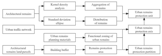
Figure 1.
Integrating zoning protection technology routes (Drawn by the author).
3. A Global Perspective on Urban Planning of Xinjing of Pseudo-Manchukuo in the Same Period
3.1. Study Area
At the beginning of the 20th century, new ideas and theories were emerging in the urban planning field, and urban planning ideas, methods, and techniques that emerged and developed in Europe and the United States were rapidly introduced to Japan. After the Russo–Japanese War, Japan gained control of the Russian railways in Changchun and established the Manchurian Railway Company (Manchurian Railway) in 1906 to plan and build the Manchurian Railway Annex with Changchun Railway Station as the core [27]. These plans and architectural complexes were the product of Japanese imperialist colonial rule, and at the same time allowed the most advanced international planning ideas and architectural techniques of the time to be experimented with in China. The planning and construction of the cities of pseudo-Manchukuo resulted in the creation of functional urban zones and architectural complexes of different styles, and the city of Xinjing became a metropolis of nearly one million people [28,29]. There are precedents for the spatial structure of the Xinjing planning of pseudo-Manchukuo, and this planning technique was repeatedly used in the planning of many capitals and important cities of the same period. The planning techniques of Xinjing were based on the successful experience of established western capital planning as well as the reinforcement of colonial rule in the planning of colonial capitals, while making a culturally inclusive gesture in architectural style. The research was conducted in the context of global colonialism, which deepens the understanding of the spatial layout of the Xinjing planning in a broader context. With the growing enthusiasm for urban renewal and sustainable development, the issue of how to protect urban ruins in general has become an issue of concern, providing a reference for urban renewal and preservation of urban remains in modern Tohoku, modern China, and “capital planning” around the world. The Japanese envisioned Changchun as the new capital for the purpose of colonization. The construction of the new capital of pseudo-Manchukuo adopted all of the most advanced planning theories and architectural styles in the world at that time and was at that time the first in Asia to do so. Changchun was a testing ground for Western theories in China and was of great significance for both relic planning and the urban renewal of Chinese cities. With Changchun as the object of our study, we can provide lessons for the development planning of urban relics in former Japanese colonial cities (e.g., Dalian, Harbin, Anshan, etc.) and for the sustainable development of Eastern and Western cities in the same period.
3.2. Urban Spatial Structure
L’Enfant’s Washington planning in 1791 and Griffin’s Canberra planning in 1911 are classic examples of modern urban planning and are also the main objects of reference and imitation in modern Changchun planning. Across the whole of modern Changchun’s planning, the planning of the Manchurian Railway Annex references the planning of American colonial cities as represented by the Washington planning, while the Xinjing planning of the pseudo-Manchukuo after 1932 refers more to Canberra. The Washington planning adopted a junction method in which radiating roads directly cut the grid network, resulting in more sharp-angled street profiles at the junction (Figure 2a). In this way, the urban form can have a strong commemorative effect, but the disadvantage is that the shape of the street profile on both sides of the main road is irregular, which is not conducive to commercial development [30,31]. The roads planned for the Manchurian railway affiliated area around Changchun railway station are similar to those in L’Enfant’s Washington planning (Figure 2b). However, Canberra’s planning addressed the problem of too many sharp-edged plots. The core plaza is designed in a hexagonal or octagonal shape, and the street profiles on both sides of the radiating road are arranged parallel to the road, so that when the land in the two directions intersects, an obtuse-angled plot is generated instead of an acute-angled plot, which can be more effectively and efficiently used [32]. The contradiction between form and function is possibly avoided (Figure 2c).
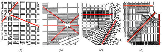
Figure 2.
Urban spatial structure in different places (red line drawn by author). (a) Washington planning. (b) Manchurian railway affiliated area planning. (c) Canberra planning. (d) Xinjing planning.
The road network form used in Xinjing planning of the pseudo-Manchurian period is the form of square grid and radiation, but different from the previous planning, the road network structure has been improved. The Xinjing planning in 1932 adopted more of the road layout form similar to Canberra, where a radial trunk road was established first and the road network was then adjusted according to the trunk road, and where the core square was designed as a circle or polygon, and the radiating roads were on both sides. The street profile is arranged parallel to the road, and an obtuse-angled street profile is formed inside to solve the problems caused by the intersection of the two directions of the road network, which is more conducive to land development and commercial operation and provides space for the rapid development of urban construction (Figure 2d). Today, most of the main street systems built during the Manchurian period have been preserved, but some streets (such as Jiefang Overpass) have not been implemented as originally planned. Starting from the northern Xinjing Railway Station (now Changchun Railway Station), a large circular square has been used to establish a traffic center, with Datong Street (now People’s Street) as the main axis and Shuntian Street (now Xinmin Street) as the secondary axis, The urban space main structure of Changchun is formed by the combination of a baroque ring square, radiating main street and grid-like secondary street [33].
3.3. Urban Function Zoning
Based on the consideration that Changchun was weakly influenced by domestic and foreign political forces and had no urban planning at that time, Changchun became a laboratory for the implementation of western urban planning theories by Japanese planning groups influenced by western planning ideas. Thus, the planning theories of “garden city”, “industrial city”, and “functional urban zoning” were fully applied to the urban planning and urban spatial structure of Xinjing. From the end of the 19th century, with the concentration of population and industrial production activities in urban areas, the free expansion of cities and towns led to a series of problems such as construction chaos, ecological damage, and serious health and safety conditions. Therefore, proposed schemes such as “garden city” and “social city” sought to replace the crowded metropolis, especially the idea of uniting cities and villages and connecting them by railway to form a regional “social city”, something which inspired many regional planning scholars and groups. The United Kingdom was the first country to build a green belt around the city. In 1932, a “green belt” of more than 100 square kilometers was built outside London (Figure 3), and it was protected by law. This “green belt” has the following three main functions: firstly, to prevent the city from expanding further outward; secondly, to protect the agriculture in the suburbs; and thirdly, to provide leisure places for the residents of the city center. In 1944, therefore, a belt about 10 km wide was built around the city of London [34,35,36]. The planning of Xinjing attached great importance to the construction of a park green space system and had a detailed park green space planning system (Figure 4). Xinjing set up parks and green spaces within the urban planning area and green spaces outside the urban planning area. The small rivers and low-lying wetlands in the planning area were all planned as park green spaces, and river embankments were built to protect them [37]. Setting urban boundaries to prevent the infinite expansion of the city through this system of delineation, while preventing wind and sand, was a very forward-looking approach at that time.
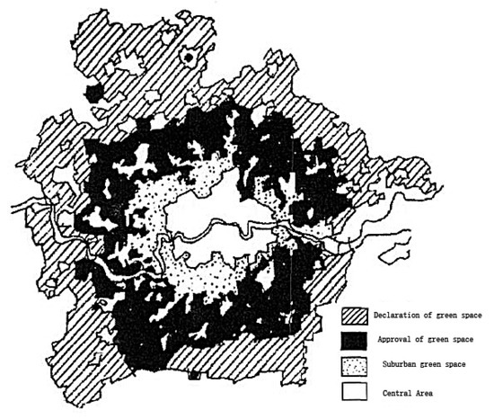
Figure 3.
London periphery green belt (Collected and drawn by author).
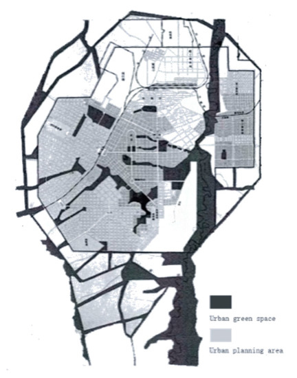
Figure 4.
Xinjing periphery green belt (Collected and drawn by author).
The Athens charter was published in 1933. This charter believes that many activities in cities can be divided into four basic types; living, work, recreation, and transportation. This is the “basic classification” of urban planning research and analysis and proposes that the four main functions of urban planning each have their own optimum conditions for development [38]. This functional zoning system was developed to effectively solve the drawbacks caused by the mixing of various functional areas at that time and was an advanced western urban planning theory. In the planning area, according to the topographical features of Changchun, a city square would be set up on an elevated platform, and the rivers and various low-lying wedge-shaped belts would be connected to form an urban green space system. Based on this, the functional zoning of urban land in the pseudo-Manchurian Xinjing would be established. In the 100 km2 national capital planning and construction area, the land is divided into two categories: official land and civilian land according to their functions. Official land occupies 47 km2, including government office and related land, road land, public facility land, parks, and sports grounds, while civil land occupies 53 km2, including residential, commercial, industrial, undesignated, and special land. These are, in reality, further divided into ten types of land (Table 2).
Table 2.
Allocation of planned land within the urban planning area of Xinjing.
3.4. Urban Architectural Style
The planning and construction of the pseudo-Manchu has given the city a new look. With the completion of the three phases of construction, Changchun has taken on the scale of a cosmopolitan city. In the southern extension of the main axis of People’s Street and the areas on both sides of the secondary axis of Xinmin Street, Western-style buildings such as military and government organs, economic groups, cultural and educational units, municipal utilities, religious rituals, and residential houses are laid out. Compared with other colonial cities, the architecture of modern Changchun has the same architectural style: the Taiwan Governor’s Office uses large-scale and magnificent Western historical style buildings to demonstrate the authority of the invaders in the colony (Figure 5a); the North Korean Governor’s Office breaks the original pattern of the palace, it symbolizes that the colonial regime replaced the legitimate ruling power of the Korean kingship (Figure 5b); likewise, the pseudo-Manchukuo Ministry of Justice in Changchun has similarities, with the entire building in the shape of a cross and reinforced concrete structure. The main entrance faces west, the main body has three floors, one underground, and a three-story tower was built right in the middle. The tower has arch-shaped windows on the ground floor and bar windows on the second and third floors [39]. The middle and upper part of the main building is equipped with hillside, horsetail and heavy eaves (Figure 5c). These buildings fully introduce European and American architectural concepts and techniques, and the architectural forms are either classical or historicist in style, with obvious colonial political overtones as a testimony to the recent colonial wars [40].
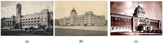
Figure 5.
Different local architectural representatives of the pseudo-Manchukuo period (Data source: The data for (a) comes from: https://zh.wikipedia.org/wiki/File:Government-general_of_Taiwan.jpg, accessed on 14 January 2022; The data for (b) comes from: https://zh.wikipedia.org/wiki/File:Japanese_General_Government_Building.jpg, accessed on 14 January 2022; The data for (c) collected from: “Changchun Modern Architecture Illustrated 1932–1945” book.). (a) Taiwan Governor’s Office. (b) North Korean Governor’s Office. (c) Ministry of Justice of pseudo-Manchukuo.
4. Results and Discussion
4.1. Evolutionary Features of the Xinjing Planning of Pseudo-Manchukuo
4.1.1. Urban Road Network System and Spatial Structure Are Basically Preserved
Through the comparison of the four periods of planning and the current situation, it can be seen that the overall spatial pattern of the main urban area in each period has a high degree of similarity with the pseudo-Manchukuo city planning as a comparison, and that the main urban functional zoning has been preserved and continued. Due to the disorderly construction of the city from the 1950s to 1970s and the need for reform and opening up of the old city, some urban functional zoning has not retained function conversion. As a result, due to the city’s function zoning, transportation system and the differences in planning pseudo-Manchukuo, some of the old and new urban areas are not effectively connected. Pseudo-Manchukuo city planning and construction in urban space established Xinjing Station Square (now Changchun Station Square) as the starting point and Datong Street (now People’s Street) as the main axis of the city, with ring-shaped square and radial street articulation, road network geometry, and natural topography integration as one. The new Beijing Station was intended as the traffic center, with the planned new Beijing West Station as the secondary traffic center. Although Changchun city has gone through nearly a century of history, the baroque circular square, the combination of radiating main streets and grid-like secondary streets, and the “dual-axis” and “multi-center” urban architecture of the main and secondary parts of the city have been preserved in all periods. The main urban function areas and urban functions of the pseudo-Manchukuo period have continued in Changchun in various periods, especially at various stages of urban development, and the construction of the ring-shaped square has become an important urban symbol of Changchun. The envisioned contrast with the current urban road and spatial structure in Figure 6a,b.
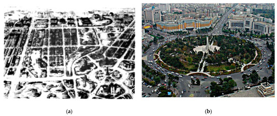
Figure 6.
Urban planning of People’s Street in different periods (Data source: The image for (a) comes from: “Pseudo-Manchukuo Capital Planning” book; The image for (b) comes from: https://www.163.com/dy/article/EKM9SQ1E0525VVNS.html, accessed on 14 February 2022). (a) Prediction of Xinjing planning. (b) Current situation of Changchun.
4.1.2. Urban Green Space System and Function Zoning Turnover
Through image comparison analysis and field survey, it can be seen that although the pseudo-Manchu architectural complexes in Changchun have been extensively destroyed, the functional areas of the city during the pseudo-Manchu period have been preserved, and their main functions have been continued. In the pseudo-Manchukuo urban planning and design, based on considerations of urban landscape, urban drainage, war preparation, earthquake and fire prevention, and alternate urban water sources, urban rivers were planned with the concept of an idyllic city, using the distribution of urban topography and the Yi tong river water system, and combined with green belts as urban rainwater regulating pools (Figure 7a).In this design, the green area and its water retention function greatly beautify the city. The function of rainwater retention relieves the pressure of surface runoff formed by high-intensity precipitation, and the pond is connected to the Yi tong river, which can drain urban floods in time and prevent the formation of urban flooding. The open green space system is usually used as a place for rest and play, as a place for disaster mitigation and avoidance in emergency situations, and as a white area for urban planning [41,42]. In 1965, we can see that the urban green space system also played the role of regulating water systems in the early years of the country (Figure 7b), but after the founding of the country, due to the demand for residential land from industrial construction and urbanization after the reform and opening up, most of the green space system was occupied and developed as residential land, and the planned connected water systems were gradually divided into the remains of independent ponds (Figure 7c,d). It is this loss of the regulating function of water bodies that has caused many problems in recent years, such as urban flooding and the heat island effect. In addition, to prevent blind urban expansion and control urban sand, a hundred-meter-wide green zone was set up at the edge of urban planning, which has long disappeared with the expansion of modern cities.
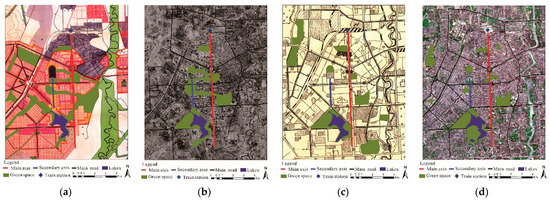
Figure 7.
Images of the main city of Changchun in different periods (All images are marked by author).
4.2. Current Status and Spatial Distribution Characteristics of Architectural Remains of the Pseudo-Manchukuo Period
The pseudo-Manchukuo remains in Changchun City have different architectural styles, which are the concentrated expression of Eastern and Western architectural ideas and architectural techniques at the beginning of the last century. Japanese military and government agencies and community buildings are mainly distributed on both sides of People’s Street on the main axis, and the executive area and main official residences of the Manchukuo government are distributed on both sides of Xinmin Street on the secondary axis. These buildings imitate or draw lessons from the “Manchurian” style. The basic form of the building emphasizes symmetrical composition, highlights the visual effect of the roof, and pays attention to the proportional relationship of windows. Within the rectangular area north of Liberty Road, east of People’s Street. This type of building has a variety of styles and scales, mostly using reinforced concrete structures with 1–2 floors underground and 3–7 floors above ground. Cultural, educational, and scientific research buildings are mainly distributed in the southern sections of People’s Street and Nan ling. Near the Nan ling Campus of the University, the buildings are mainly low-rise and multi-story European-style buildings, generally with Gothic pointed arches, classical doorways, pointed vaults, and sloping roofs on the front facade [43]. The architecture of the Manchurian period is similar to Japanese architecture, and the scale of the building is huge, which is used to promote and penetrate Japanese culture and religious thought. To meet the needs of colonial expansion and Japanese immigration, the Manchukuo government carried out large-scale construction of municipal infrastructures such as water diversion, water supply, drainage, and greening. The municipal infrastructure buildings are mainly steel-framed or reinforced concrete structures [44,45]. The building is well preserved.
The classification of architectural remains are based on the planning relics and architectural relics visited on the spot which are divided into five categories according to the characteristics of the completeness of the preservation status and the completeness of protection. The first category is for the historical buildings with a clear protection level and regular maintenance and is used by government agencies and institutions. A typical example of this is the State Council of Manchukuo (now the Xinmin Campus of Jilin University) (Figure 8a,b) which has been altered and expanded along the lines of the architectural style of the Manchurian period. Another typical example is the Manchurian Railway Xinjing Branch (now the Shenyang Railway Director Chun Office) (Figure 8c,d). While the original frame and function of other typical buildings such as the Xinjing Central Post Office (now Changchun Post Office) (Figure 8e,f) have been maintained. The fourth category are not renovated according to the original style, nor are they demolished and rebuilt at the site of the original remains, but have become buildings used by enterprise groups and individuals, a typical example of this category is the pseudo-Manchurian San Zhong Jing Department Store (now Changchun Department Store) (Figure 8g,h). The fifth category comprises buildings that have not been constructed and protected, and are currently unoccupied, these include buildings such as the Tian Xing Powder factory (now an abandoned building) (Figure 8i,j).
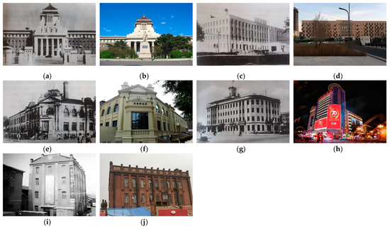
Figure 8.
Pseudo-Manchukuo building evaluation classification pairs (The images of (a,c,e,g,i) come from: “Changchun Modern Architecture Illustrated 1932–1945” book; The images of (b,d,f,h,j) photoed by author).
4.3. The Construction of Remains Protection Areas Based on Urban Functional Areas
Meanwhile, using the method of geospatial analysis, the spatial proximity and aggregation degree of the geographical distribution pattern of the remains were studied, and the spatial distribution characteristics were analyzed. This work would provide the basis for the integrated protection zoning of the pseudo-Manchukuo sites in Changchun City. Through nearest neighbor and autocorrelation analyses, the nearest neighbor ratio was calculated to be 0.716467, and the autocorrelation index was 0.743161, indicating that the spatial analysis of architectural sites has a related clustered distribution pattern. The results show that the existing building sites are mainly distributed along People’s Street and form multiple centers in space. On this basis, using the standard deviation ellipse direction distribution method, it is found that the length of the long axis and the short axis of the standard deviation ellipse of the distribution space of the building sites are significantly different. The main feature is the north-northeast orientation of the long axis, and the architectural sites are concentrated along the direction of People’s Street (Figure 9).
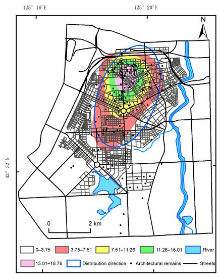
Figure 9.
Standard deviation ellipse analysis and kernel density analysis results.
Based on the spatial distribution characteristics of the sites combined with the functional areas of the city planning of the pseudo-Manchurian city, the protective zoning of the city sites of the pseudo-Manchurian city was constructed. According to the current characteristics of the sites and the distribution characteristics of the sites in the spatial analysis, it can be found that the sites in the main urban area are distributed along the main and sub-axes, as well as the Manchurian Railway Attachment, the People’s Square, the South Square, the Pseudo-Manchukuo Palace, and the West Fourth Road. The block at the center has a clustered distribution characteristic. The buffer zone analysis method was used to establish the buffer zone based on the boundaries of the parcels where the sites are located. The national level is expanded by 250 m, the provincial level is 150 m, and the city and county levels are 75 m. The construction control zone is the same distance. For the parcel where the site is located, a buffer zone was established with the above-mentioned protection extension range as the radius, and the overlapping area of the composite buffer zone was merged into the same zone (Figure 10). Based on the analysis results and the functional divisions of the pseudo-Manchurian urban planning, the scope area was adjusted to form eight heritage protection areas in the central area of the city. The number of sites in each protection zone was used as the standard to assign scores to each zone and determine the protection zone level (Figure 11). The first level comprises the People’s Street Historical and Cultural Reserve (I-1) and the South-Manchurian Railway Affiliated Reserve (I-2); the second level comprises the Xinmin Street Historical and Cultural Reserve (II-3), the Pseudo-Manchukuo Palace History and Culture, and the protection zone (II-4); the third grade comprises the Nanling Culture, Education, Science, Health, and Culture Protection Zone (III-5) and the commercial port and civilian residence protection zone (III-6); the fourth grade comprises an excellent residential protection zone (IV-7); and the fifth grade is classified as the Xinjing Railway Station Transportation Reserve (V-8).
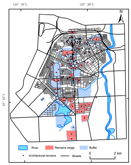
Figure 10.
Buffer build merge results.
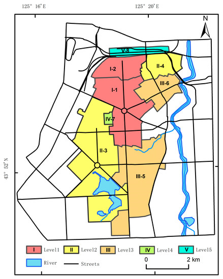
Figure 11.
Resource integration reserve for pseudo-Manchukuo remains.
4.4. The Development of Urban Monuments Conservation in International Perspective
The development of the concept of urban monuments conservation is a process of expanding the objects and scope of conservation, improving and progressing the conservation concept and methods, and proceeding simultaneously with the development of human society and economy. It is helpful to compare the conservation of urban monuments in a global perspective in order to establish a scientific and comprehensive conservation and design concept for the planning and design of urban monuments.
The UK is an early adopter of urban heritage conservation, and its series of laws and regulations have had a great impact on the conservation of cultural heritage in Europe and the world. At present, the UK has established a hierarchical heritage protection system with national legislation as the core, monuments and remains, registered buildings, conservation areas and historic towns. In the overall environment of historical and cultural heritage, it is insisted upon that high-rise modern buildings are prohibited in the area, and if new buildings are to be built, they must be in line with the architectural characteristics of the historical era in which they are located [46]. The old heritage buildings can only be renovated and used for their internal facilities, while the shape and structure of the buildings must be maintained in their original historical appearance [47]. This is an organic combination of the preservation of historical and cultural heritage and the modernization of the city, which can meet the needs of people for modern living facilities while perfectly preserving the historical appearance of ancient buildings and other historical and cultural heritage surroundings.
In 1962, France promulgated the Marlowe Decree, which set the goal of designating valuable historic areas as historic districts, stipulating that buildings in these districts are not to be demolished arbitrarily and that repairs and alterations must be consulted, evaluated and approved by the state architect. Preservation and use of the historical heritage, i.e., heritage buildings and the surrounding space should be protected together [48,49]. It is stipulated that the construction of new buildings be strictly controlled when in the same area as historical and cultural buildings, and the height and appearance of new buildings are guaranteed to be in harmony with the surrounding environment, so as to protect the historical pattern of urban space [50]. The boundaries for the protection, repair or renewal of the material elements of the city, including buildings and their parts, street squares and courtyard spaces, green spaces and greenery, and ground are defined clearly for each area and for buildings, remains, greenery and trees and passages. In terms of value judgment, there are two categories: preservation and demolition. These are judged from various aspects such as the construction period, the history and aesthetic value of the building itself.
Since the Second World War, Japan has been vigorously developing its economy and paying attention to the preservation of its tangible and intangible cultural heritage. Japan’s Cultural Property Preservation Law classifies cultural properties into five major categories: tangible cultural properties, intangible cultural properties, folkloric cultural properties, monuments, and traditional architectural complexes [51,52,53,54]. The specific conservation procedures include five main elements: preservation survey, establishment of conservation regulations, delineation of preservation areas, preparation of preservation plans, and selection of preservation areas for important groups of traditional buildings [55,56]. For the overall environment around the historical cultural heritage, firstly, the unity and continuity of space and visual perception should be ensured; secondly, the original living and organizational environment of the region should be maintained; and thirdly, the close relationship between the traditional architectural groups and their inseparable surroundings should be taken care of.
It has been a century since the formal promulgation of the national decree in the late Qing Dynasty, during which a series of challenges were experienced until the establishment of New China, and only then did China officially embark on the road of gradually improving the legal system of heritage conservation. Currently, for the protection of relics, China has formulated the “Law of the People’s Republic of China on the Protection of Cultural Relics” in 2002 for the protection of tangible cultural heritage. First of all, the policy of heritage protection has been made clearer, emphasizing that protection and rescue are primary, while utilization should be premised on protection and rescue, and is within a reasonable scope and limited utilization. Secondly, the protection of historical and cultural districts has been formally added for historical and cultural cities, historical and cultural towns, streets, villages, etc., to raise awareness of the overall protection of the historical landscape. This is not only for the historical and cultural heritage itself, but also for the surrounding environment to which it is closely related and for the historical landscape, for both of which the requirements of protection have been raised. Third, for the protection of immovable cultural relics, the people’s governments at all levels should be instructed to pay attention to the protection of cultural relics, and to correctly handle the relationship between economic construction, social development and the protection of cultural relics, to ensure the safety of cultural relics [57,58,59].
From the legislation of heritage protection and the actual protection work, China has formed a perfect system of heritage-type protection objects from cultural to natural, from material to immaterial, with the gradual enrichment of protection objects and the gradual expansion of protection scope. As for the use of heritage, especially the protection and use of historical and cultural heritage and its surrounding environment, China has been exploring and practicing for many years and is on the road to a mature environmental protection and use of historical and cultural heritage and its surrounding environment.
4.5. Suggestions for the Overall Conservation of Urban Remains in Changchun
4.5.1. Proposal to Establish an Overall Protection System for Urban Planning Areas
In the 21st century, the city of Changchun has grown rapidly and, as of 2019, with seven districts under its jurisdiction (and including five development zones), an urban area of 4906 square kilometers and a built-up area of 642 square kilometers the new urban area of Changchun will further develop. This is especially true with the full promotion of the synergistic development of the city of Changchun and Gongzhuling (a municipal county-level city on the western side of Changchun) and the implementation of the strategy of making every effort to promote the construction of a modern metropolitan area in Changchun. In contrast to the new urban areas, the old urban areas are languishing. There is an urgent need to strengthen the legislation and top-level design of the urban renewal system at the governmental level, and it has been proposed to set up a protection zone for pseudo-Manchukuo urban planning and urban construction sites from the Itong River in the east to the railway in the west, and from the railway station in the north to Prosperity Road in the south. Furthermore, this zone would strengthen the articulation and coordination between the old and new urban areas through the preparation of a historical urban functional area protection plan, which would protect the relics and sites of pseudo-Manchukuo urban planning and construction. The conservation of the pseudo-Manchukuo urban planning and construction relics and sites will be carried out. The main spatial structure of the main urban area of Changchun, i.e., the urban planning framework of the pseudo-Manchukuo period, which is a combination of circular squares, radiating main streets and grid-like streets, is protected, and the planning characteristics of “two axes and multiple centers” are maintained. The main functional areas of transport, commerce, housing, education, science, health, and urban green space are clearly defined and protected in conjunction with the pseudo-Manchukuo urban heritage site, while the new urban development area is effectively connected and transitioned to the surrounding area, while protection signs are established in the boundary area. The characteristics and advantages of Changchun’s old urban areas are continuously explored, and the relics and sites of Changchun’s pseudo-Manchukuo urban planning are protected as a whole and restored in a targeted manner to continue and develop their effective urban functions and achieve the coordinated development of the old and new urban areas.
4.5.2. Proposal to Establish a “District-Axis-Point” Protection Model for Urban Planning and Architectural Heritage
The pseudo-Manchukuo sites in Changchun are generally clustered and locally dispersed, and conservation measures have been taken for each of the construction sites in Changchun, but holistic and zoning conservation is not yet fully on the agenda. The spatial distribution characteristics of the sites, derived from various geospatial analysis methods, show that the existing construction sites have a cluster distribution pattern and a north-north-east orientation, with the sites mainly distributed along the main axis of People’s Street and the sub-axis of Xinmin Street, forming multiple centers in space, and the site types are closely related to the functional areas of the city. Each of the eight conservation zones established using the buffer zone and spatial overlay methods and the typical sites in the zones are an important reflection of the functional zoning of the pseudo-Manchukuo city plan.
It has been proposed to integrate the architectural sites and establish a three-in-one conservation model of “district-axis-point” based on the eight urban functional zones and the main and secondary axes of People’s Street and Xinmin Street, fully restoring the historical district and architectural style, establishing a core conservation area, and effectively coordinating with the modern urban district. The People’s Square-centered People’s Street Historic and Cultural Conservation Area maintains and perpetuates the core position of People’s Street as a public service center and shapes the main axis of Changchun’s public space; the Xinmin Street Historic and Cultural Conservation Area, centered on the Culture Square, relies on educational, cultural, and medical units to uphold the historical style of Manchurian architecture and solidify urban culture; the pseudo-Manchukuo Palace Historic and Cultural Conservation Area, centered on the Pseudo-Manchukuo Palace, focuses on the Manchurian Railway Annexes Historic Reserve, to stimulate the economic vitality of the traditional commercial area and carry out systematic research on the heritage of the modern Northeast Railway in the Manchurian Railway Annexes; the Commercial Port and Civilian Residence Reserve, to trace the characteristics of the old and ethnic industrial and commercial gathering places and create a cultural space with a unique Kanto commercial atmosphere [60]; the Nan ling the science, education, culture, and health conservation area is a place to build a cultural system with Nan ling’s characteristics under the intermingling of multiple cultures; the Xinjing Railway Station Conservation Area and the Fine Housing Conservation Area have few surviving sites, so the later urban construction and renovation should focus on harmonizing with the style of historical buildings and pseudo-Manchukuo sites and give them priority protection [61]. In the urban renewal process, the “district-axis-point” system of conservation is brought into play, the protected areas are effectively integrated with the functional areas of the city, and the styles of the new neighborhoods inside and outside the district are effectively linked with the styles of the axes and dotted remains, to ensure the effective inheritance of the city’s history and culture while enhancing the new appearance of the old city.
4.5.3. Proposal to Encourage the Effective Functional Restoration of Urban Planning and Construction Function Areas
The functional zoning of the pseudo-Manchukuo city plan is complete, and its systematic and scientific nature still has significance for the planning and development of modern Changchun city. Reasonable urban functional areas that have not been preserved and areas that have not been implemented according to the plan can be selectively rebuilt and renewed to continue their urban functions, solve the current urban traffic, disaster mitigation, and avoidance problems, as well as restore the historical appearance of the city and enhance the urban landscape.
The multi-year average precipitation in Changchun is 669.7 mm, and the maximum annual precipitation is 1014.8 mm, which is concentrated in summer with a high intensity of instantaneous precipitation. As the hardened surface of the city continues to increase, and the retention and “puddle-filling” function of urban green space decreases, surface runoff increases, resulting in the occurrence of urban waterlogging and flooding of residential areas, etc. On 2 June 2019, the regional waterlogging sections reached 56, which seriously affected urban production and life. Meanwhile, the reduction of urban green space has led to the enhancement of the urban heat island effect and a decrease in carbon absorption capacity, and the number of extreme summer heat days in Changchun has increased year by year in recent years [62,63,64,65]. Based on the above problems, it is necessary to restore water systems and green spaces as resilient urban spaces, especially in today’s policy of “carbon peaking” and “carbon neutrality”, and also as “urban white areas” to reserve space for urban disaster prevention and avoidance.
5. Conclusions
The article begins with a summary analysis of various international charters, declarations, and regulations concerning historical and cultural heritage in recent times. The theoretical development of urban heritage conservation has been investigated, and the evolution and differences of urban development planning in the modern era from the perspective of zoning conservation of urban heritage have been established. The differences in the evolution of the urban spatial structure of the pseudo-Manchukuo Xinjing planning in the same period with Washington and Canberra areas, the origin and evolution of the idea of urban functional zoning, and the design style of urban construction sites have been analyzed from a global perspective. These advanced urban planning ideas provide references for exploring modern urban ruins development planning and sustainable urban development.
The history of the development of urban relic conservation has been established in an international perspective, with reference to three early cities that carried out relic conservation in the UK, France and Japan. In the UK, the conservation of urban monuments was the earliest, and a hierarchical heritage conservation system was established with national legislation as the core, including monuments and sites, existing buildings, conservation areas, and historic cities; in France, new buildings are strictly controlled in the area of historic and cultural buildings and the surrounding environment, and the height and appearance of new buildings are coordinated with the surrounding environment, so as to protect the historical pattern of urban space; in Japan, the conservation of urban monuments is based on the overall landscape of the environment and the sustainable development of the city. The protection of urban monuments in Japan is based on the overall landscape of the environment, with the street as the axis and the area within sight of the street as the core area, and also includes some details of the original aborigines’ living content.
Taking the pseudo-Manchukuo urban planning in Changchun as an example, we systematically analyzed the characteristics of the evolution of the pseudo-Manchukuo planning: the road network system and spatial structure of the city are basically preserved, while the green space system and functional zoning of the city have been changed. The spatial distribution characteristics of architectural relics were analyzed through field investigation of the existing architectural relics in pseudo-Manchukuo and comparison. Based on the spatial distribution characteristics of the ruins, five integrated protection zones of the pseudo-Manchu city ruins are constructed by combining the functional zones of the pseudo-Manchu city planning.
From the perspective of the protection of urban relics with the sustainable development of the city, three suggestions were proposed for the urban development planning of Changchun: firstly, to establish a holistic protection system for the pseudo-Manchu urban planning area, strengthen the connection and coordination between the old and new urban areas, and protect the pseudo-Manchu urban planning and construction relics and sites as a whole; secondly, to establish a “district-axis-point” protection model for urban planning and architectural heritage. Thirdly, to restore the effective functioning of pseudo-Manchu urban planning and construction functional areas, along with the continuation of its urban functions, the solution of current urban traffic, disaster mitigation and disaster avoidance problems and the enhancement of urban landscape.
Shortcomings and Prospects: In this paper, there are problems in the collection of historical data, such as incomplete data or unidentifiable data. The idea of the “new capital” planning in pseudo-Manchukuo was influenced by the European urban beautification movement, the idyllic city movement, and some modern urban planning ideas, and different cities in the world have similar characteristics to Changchun. In the context of the preservation of the relics of modern urban planning, if we use more information on the relics of urban planning and summarize the specific correlations and differences between these plans, it will be useful for us to study the theory of modern urban planning and the sustainable development of urban planning nowadays.
Author Contributions
Conceptualization, formal analysis and methodology, J.Z. and J.W.; investigation and resources, J.T., S.T. and W.Z.; writing—original draft preparation, J.Z.; writing—review and editing, J.W. All authors have read and agreed to the published version of the manuscript.
Funding
The authors gratefully acknowledge the support provided by the “Thirteenth Five-Year” Science and Technology Project Fund of Jilin Provincial Department of Education (No. JJKH20180164KJ); Open Fund Project of the Key Laboratory of Urban Land Resources Monitoring and Simulation of the Ministry of Natural Resources “Research on Process Design and Application of Intelligent Monitoring of Remote Sensing Image Changes Combined with Domain Knowledge” (No. KF-2018-03-020).
Institutional Review Board Statement
Not applicable.
Informed Consent Statement
Informed consent was obtained from all subjects involved in the study.
Data Availability Statement
Not applicable.
Conflicts of Interest
The authors declare no conflict of interest.
References
- Alrawi, A.K.; Qasim, S.S. Urban Management of City Centers the Road to The Sustainable Development (Sustainable Land Use Management). IOP Conf. Ser. Earth Environ. Sci. 2022, 961, 012090. [Google Scholar] [CrossRef]
- Michalina, D.; Mederly, P.; Diefenbacher, H.; Held, B. Sustainable Urban Development: A Review of Urban Sustainability Indicator Frameworks. Sustainability 2021, 13, 9348. [Google Scholar] [CrossRef]
- Kowarik, I.; Fischer, L.K.; Kendal, D. Biodiversity Conservation and Sustainable Urban Development. Sustainability 2020, 12, 4964. [Google Scholar] [CrossRef]
- Ivanova, G.N. Standardization of sustainable urban development measurements. J. Phys. Conf. Ser. 2021, 1889, 032046. [Google Scholar] [CrossRef]
- Okano, H.; Samson, D. Cultural urban branding and creative cities: A theoretical framework for promoting creativity in the public spaces. Cities 2010, 27, S10–S15. [Google Scholar] [CrossRef]
- Revell, T. City ruins can tug at purse strings. New Sci. 2017, 236, 14. [Google Scholar] [CrossRef]
- Ren-Zhi, H. Ancient city ruins in the deserts of the Inner Mongolia Autonomous Region of China. J. Hist. Geogr. 1985, 11, 241–252. [Google Scholar] [CrossRef]
- Sorbo, E. Ruins of Memory: A Sustainable Conservation for the Material and Immaterial Values of the Former Psychiatric Hospitals in Italy. Procedia Eng. 2016, 161, 2198–2202. [Google Scholar] [CrossRef]
- Zhou, Y.; Sun, Z.-E.; Gao, Q. Performance-based fire Protection Design of Ruins Protection Pavilion Based on Air-supported Membrane Structure. Procedia Eng. 2016, 135, 486–494. [Google Scholar] [CrossRef]
- Davies, T.; Isakjee, A. Ruins of Empire: Refugees, race and the postcolonial geographies of European migrant camps. Geoforum 2018, 102, 214–217. [Google Scholar] [CrossRef]
- Akcay, C.; Sayin, B.; Yildizlar, B. The conservation and repair of historical masonry ruins based on laboratory analyses. Constr. Build. Mater. 2017, 132, 383–394. [Google Scholar] [CrossRef]
- Kargas, A.; Loumos, G.; Mamakou, I.; Varoutas, D. Digital Routes in Greek History’s Paths. Heritage 2022, 5, 742–755. [Google Scholar] [CrossRef]
- Abbott, C. George Washington’s Final Battle: The Epic Struggle to Build a Capital City and a Nation. J. Am. Hist. 2021, 108, 365. [Google Scholar] [CrossRef]
- Brown, T.J. Building Washington: Engineering and Construction of the New Federal City, 1790–1840. J. Am. Hist. 2019, 106, 455–456. [Google Scholar] [CrossRef]
- Yglesias, C. To Build a Metaphor: L’Enfant’s Design for the City of Washington. J. Plan. Hist. 2019, 18, 172–195. [Google Scholar] [CrossRef]
- Yglesias, C. L’Enfant’s Washington: The figure of the President in the capital of the Republic. Plan. Perspect. 2021, 18, 172–195. [Google Scholar]
- Mees, P. A centenary review of transport planning in Canberra, Australia. Prog. Plan. 2014, 87, 1–32. [Google Scholar] [CrossRef]
- Banks, J.C.; Brack, C.L. Canberra’s Urban Forest: Evolution and planning for future landscapes. Urban For. Urban Green. 2003, 1, 151–160. [Google Scholar] [CrossRef]
- Stangl, P. Restoring Berlin’s Unter den Linden: Ideology, world view, place and space. J. Hist. Geogr. 2006, 32, 352–376. [Google Scholar] [CrossRef]
- Barranha, H.; Caldas, J.V.; Da Silva, R.N.N. Translating heritage into museums: Two architectural strategies inside Lisbon Castle. J. Cult. Heritage Manag. Sustain. Dev. 2017, 7, 33–47. [Google Scholar] [CrossRef]
- Akira, K. Pseudo-Manchukuo Capital Planning, 1st ed.; Social Science Literature Press: Beijing, China, 2011; pp. 102–200. ISBN 978-7-5097-2334-0. [Google Scholar]
- Yang, Y. Changchun Modern Architecture Illustrated 1932–1945, 1st ed.; Jilin Literature and History Press: Changchun, China, 2011; pp. 58–108. ISBN 7-5472-0687-4. [Google Scholar]
- Yang, J.; Mo, W. Changchun Urban Planning and Architecture Research in the Pseudo-Manchukuo Period, 1st ed.; Northeast Normal University Press: Changchun, China, 2008; pp. 128–200. ISBN 978-7-5602-5111-0. [Google Scholar]
- Guo, Y.-R.; Bai, Y.-Q.; Li, C.-N.; Shao, Y.-H.; Ye, Y.-F.; Jiang, C.-Z. Reverse nearest neighbors Bhattacharyya bound linear discriminant analysis for multimodal classification. Eng. Appl. Artif. Intell. 2020, 97, 104033. [Google Scholar] [CrossRef]
- Lee, W.J.; Mendis, G.P.; Triebe, M.J.; Sutherland, J.W. Monitoring of a machining process using kernel principal component analysis and kernel density estimation. J. Intell. Manuf. 2019, 31, 1175–1189. [Google Scholar] [CrossRef]
- Polajzer, B.; Brezovnik, R.; Ritonja, J. Evaluation of Load Frequency Control Performance Based on Standard Deviational Ellipses. IEEE Trans. Power Syst. 2016, 32, 2296–2304. [Google Scholar] [CrossRef]
- Thornton, M.A. Constructing Empire: The Japanese in Changchun, 1905–1945. J. Asian Stud. 2020, 79, 265–266. [Google Scholar] [CrossRef]
- Guo, Q. Changchun: Unfinished capital planning of Manzhouguo, 1932–1942. Urban Hist. 2004, 31, 100–117. [Google Scholar] [CrossRef]
- Wang, H.; Fidrmuc, J.; Tian, Y. Growing against the background of colonization? Chinese labor market and FDI in a historical perspective. Int. Rev. Econ. Financ. 2020, 69, 1018–1031. [Google Scholar] [CrossRef]
- Glaser, M.; Krizek, K.J. Can street-focused emergency response measures trigger a transition to new transport systems? Exploring evidence and lessons from 55 US cities. Transp. Policy 2021, 103, 146–155. [Google Scholar] [CrossRef]
- Antupit, S.; Gray, B.; Woods, S. Steps ahead: Making streets that work in Seattle, Washington. Landsc. Urban Plan. 1996, 35, 107–122. [Google Scholar] [CrossRef]
- Heinz, S.; Raymundo, M.; Tim, B. A spatiotemporal urban metabolism model for the Canberra suburb of Braddon in Australia. J. Clean. Prod. 2020, 265, 121770. [Google Scholar] [CrossRef]
- Wang, H.; Li, B.; Yi, T.; Wu, J. Heterogeneous Urban Thermal Contribution of Functional Construction Land Zones: A Case Study in Shenzhen, China. Remote Sens. 2022, 14, 1851. [Google Scholar] [CrossRef]
- Hickman, C. ‘To brighten the aspect of our streets and increase the health and enjoyment of our city’: The National Health Society and urban green space in late-nineteenth century London. Landsc. Urban Plan. 2013, 118, 112–119. [Google Scholar] [CrossRef]
- Zhang, Z.; Paschalis, A.; Mijic, A. Planning London’s green spaces in an integrated water management approach to enhance future resilience in urban stormwater control. J. Hydrol. 2021, 597, 126. [Google Scholar] [CrossRef]
- Holy, W.; Burchell, B. Does public space have to be green to improve well-being? An analysis of public space across Greater London and its association to subjective well-being. Cities 2022, 125, 103569. [Google Scholar] [CrossRef]
- Cao, K.; Guo, H.; Zhang, Y. Comparison of Approaches for Urban Functional Zones Classification Based on Multi-Source Geospatial Data: A Case Study in Yuzhong District, Chongqing, China. Sustainability 2019, 11, 660. [Google Scholar] [CrossRef]
- Yang, C.; He, X.; Yan, F.; Yu, L.; Bu, K.; Yang, J.; Chang, L.; Zhang, S. Mapping the Influence of Land Use/Land Cover Changes on the Urban Heat Island Effect—A Case Study of Changchun, China. Sustainability 2017, 9, 312. [Google Scholar] [CrossRef]
- Aydin, C. Kenkoku University and the Experience of Pan-Asianism: Education in the Japanese Empire by Yuka Hiruma Kishida. J. Jpn. Stud. 2021, 47, 228–232. [Google Scholar] [CrossRef]
- Smolianinova, T.A.; Kim, A.A. The Formation of European Settlements in China in the Second Half of the 19th–the First Half of the 20th Century and the Features of Their Development in Manchuria. IOP Conf. Ser. Mater. Sci. Eng. 2021, 1079, 022047. [Google Scholar] [CrossRef]
- An, Y.; Liu, S.; Sun, Y.; Shi, F.; Zhao, S.; Liu, Y.; Li, M. A partitioning approach for regional sustainability based on economic development indicators and ecological values for China. J. Nat. Conserv. 2022, 67, 126179. [Google Scholar] [CrossRef]
- Bai, L.-M.; Feng, X.-H.; Sun, R.-F.; Gao, H. [Spatial and temporal responses of habitat quality to urbanization: A case study of Changchun City, Jilin Province, China]. Ying Yong Sheng Tai Xue Bao J. Appl. Ecol. 2020, 31, 1267–1277. [Google Scholar]
- Chen, C.-C.; Fu, C.-C. Pre-World War II Manchurian Ancient Architectural Research by Japanese Architectural Historian Murata Jiro. J. Asian Arch. Build. Eng. 2016, 15, 177–184. [Google Scholar] [CrossRef][Green Version]
- Tceluiko, D.S. The architecture of banking institutions in Changchun city (1932–1945). Mater. Sci. Eng. 2020, 962, 032078. [Google Scholar] [CrossRef]
- Zadvernyuk, L.V. Historical Formation of Traditional Manchurian Housing. Bull. Pnu 2014, 33, 83–92. [Google Scholar]
- Sabri, R. From an Inconsequential Legacy to National Heritage: Revisiting the Conservation Approaches Towards the Ottoman Buildings in British Colonial Cyprus. Conserv. Manag. Archaeol. Sites 2017, 19, 55–81. [Google Scholar] [CrossRef]
- Muhammad, A.C.Y.; Ahmad, G.A. Architecture typology of a British-era colonial schools at the World Heritage Sites of Georgetown and Melaka: Impact on heritage building conservation sector. SHS Web Conf. 2018, 45, 1004. [Google Scholar]
- Cortella, L.; Albino, C.; Tran, Q.-K.; Froment, K. 50 years of French experience in using gamma rays as a tool for cultural heritage remedial conservation. Radiat. Phys. Chem. 2020, 171, 108726. [Google Scholar] [CrossRef]
- Arslanov, R.A.; Linkova, E.V.; Kozmenko, V.M. The influence of the French conservatives to the reception of the image of Napoleon I in Russia (on the example of the study of the epistolary heritage of Joseph de Maistre) (Review). Bylye Gody 2018, 47, 130–142. [Google Scholar]
- Li, Y.; Li, X.; Jiang, Q.; Zhou, Q. Historical Study and Conservation Strategies of “Tianzihao” Colony (Nanjing, China)—Architectural Heritage of the French Catholic Missions in the Late 19th Century. Buildings 2021, 11, 176. [Google Scholar] [CrossRef]
- Reyes, S.; Miyazaki, A.; Yiu, E.; Saito, O. Enhancing Sustainability in Traditional Agriculture: Indicators for Monitoring the Conservation of Globally Important Agricultural Heritage Systems (GIAHS) in Japan. Sustainability. 2020, 12, 5656. [Google Scholar] [CrossRef]
- Clopot, C. Heritage Conservation and Japan’s Cultural Diplomacy: Heritage, National Identity and National Interest. Anthropol. J. Eur. Cult. 2016, 25, 164–166. [Google Scholar] [CrossRef]
- Ohsuga, T. Network building in Japan, China and Korea for the conservation of paper-based cultural heritage within the region. Stud. Conserv. 2014, 59, S258–S259. [Google Scholar] [CrossRef]
- Okubo, T. Traditional Knowledge of Disaster-Resilient Designs in World Cultural Heritage, Japan: For Consisting Cultural Conservation and Disaster Mitigation. Abitare La Terra 2018, 17, 32–33. [Google Scholar]
- Han, J.-S.N. Conserving the Heritage of Shame: War Remembrance and War-related Sites in Contemporary Japan. J. Contemp. Asia 2012, 42, 493–513. [Google Scholar] [CrossRef]
- Charlie, Q.; Xue, J. Japanese modernity deviated: Its importation and legacy in the Southeast Asian architecture since the 1970s. Habitat Int. 2014, 44, 227–236. [Google Scholar] [CrossRef]
- Huang, G.; Gu, J.-D. An international workshop on Conservation of Cultural Heritage held at the City University of Macau, China. Int. Biodeterior. Biodegrad. 2021, 164, 105297. [Google Scholar] [CrossRef]
- Min, Q.; Zhang, B. Research Progress in the Conservation and Development of China-Nationally Important Agricultural Heritage Systems (China-NIAHS). Sustainability 2019, 12, 126. [Google Scholar] [CrossRef]
- Wu, J.; Wu, G.; Zheng, T.; Zhang, X.; Zhou, K. Value capture mechanisms, transaction costs, and heritage conservation: A case study of Sanjiangyuan National Park, China. Land Use Policy 2019, 90, 104246. [Google Scholar] [CrossRef]
- Barnard, A. Rock art: Southern Africa’s cultural treasure. Historia 2012, 57, 188–225. [Google Scholar]
- Zuo, D.; Li, C.; Lin, M.; Chen, P.; Kong, X. Tourism, Residents Agent Practice and Traditional Residential Landscapes at a Cultural Heritage Site: The Case Study of Hongcun Village, China. Sustainability 2022, 14, 4423. [Google Scholar] [CrossRef]
- Broadstock, D.; Ji, Q.; Managi, S.; Zhang, D. Pathways to carbon neutrality: Challenges and opportunities. Resour. Conserv. Recycl. 2021, 169, 105472. [Google Scholar] [CrossRef]
- De La Peña, L.; Guo, R.; Cao, X.; Ni, X.; Zhang, W. Accelerating the energy transition to achieve carbon neutrality. Resour. Conserv. Recycl. 2021, 177, 105957. [Google Scholar] [CrossRef]
- Zhao, X.; Ma, X.; Chen, B.; Shang, Y.; Song, M. Challenges toward carbon neutrality in China: Strategies and countermeasures. Resour. Conserv. Recycl. 2021, 176, 105959. [Google Scholar] [CrossRef]
- Lee, K.; Huang, C.; Chuang, S.; Huang, C.; Tsai, W.; Hsieh, C. Energy Saving and Carbon Neutrality in the Funeral Industry. Energies 2022, 15, 1457. [Google Scholar] [CrossRef]


Publisher’s Note: MDPI stays neutral with regard to jurisdictional claims in published maps and institutional affiliations. |
© 2022 by the authors. Licensee MDPI, Basel, Switzerland. This article is an open access article distributed under the terms and conditions of the Creative Commons Attribution (CC BY) license (https://creativecommons.org/licenses/by/4.0/).