Article

Mapping the Transformation Potential of Streets Using Urban Planning Parameters and Open Spatial Datasets

1
Faculty of Civil Engineering, Transportation Engineering and Architecture, University of Maribor, Smetanova ulica 17, 2000 Maribor, Slovenia
2
DOBA Faculty of Applied Business and Social Studies, 2000 Maribor, Slovenia
*
Author to whom correspondence should be addressed.
Sustainability 2022, 14(14), 8563; https://doi.org/10.3390/su14148563
Submission received: 15 June 2022 / Revised: 9 July 2022 / Accepted: 11 July 2022 / Published: 13 July 2022
(This article belongs to the Special Issue Studies on Sustainable Rehabilitation of the Built Environment)

Abstract

:
Streets with an increasingly important place function play a significant role in the contemporary discourse on sustainable cities. The paper addresses urban streets that, observed from the urban planning perspective, have the potential to be transformed into either commercial or residential shared streets. After defining urban planning parameters identified as characteristic of shared streets, streets were quantified based on an analysis of the existing shared streets in Central Europe. By setting up distinctive scenarios that could help to detect specific types of streets, open spatial datasets were used for the mapping and identification of streets that could be transformed into shared streets. The methodology was tested on the example of the city of Maribor in Slovenia. The results of the research show that the selected urban planning parameters can help to identify streets with transformation potential, whereas the basic parameters, such as the building use and the length and width of the street, help us to better understand the urban fabric in which street spaces acquire new functions. The presented mapping method could serve as a testing tool for experts, planners, decision-makers, and the interested public to identify potential street transformations.

1. Introduction

One of the key focuses in the contemporary discourse on sustainable cities has been placed on the role of open public spaces [1]. In addition to the issues of safety, accessibility, and maintenance, there is also a strong social agenda behind this discourse. Although squares, plazas, pedestrian zones, and urban green spaces may be recognised as obvious types, streets, considered as having a potential for fully functional open public spaces, can significantly contribute to and play an important role in the processes of urban transformation, bearing in mind that streets occupy from a third to half of the built-up area in cities [2]. More specifically, an average of 80% of the street space in contemporary cities is dedicated to motorised traffic, while the remaining 20% is left to pedestrians, cyclists, and possible social interactions [3]. There is a large transformative potential in the recognition of the social importance of streets, which can lead to a more effective use of urban road space, when considered and designed as an ‘exchange space’ and not only as ‘movement space’ [4]. In this sense, according to NACTO, streets can be “considered the most vital yet underutilised public spaces in cities” [5], encompassing economic and social as well as environmental aspects. Since transport emissions amount to approximately 30% of all greenhouse gasses in the EU, the European Green Deal aims to reduce these emissions by at least 55% by 2030 in the light of the sustainable urban rehabilitation of cities [6].
Streets have been associated with an increasing amount of traffic, pollution, danger, and other negative aspects of increased mobility over the past 100 years. Yet, many professionals, activists, and academics have promoted their importance and potential as the ultimate social space [7,8,9,10,11,12,13,14] since the 1960s, while calls for change have grown louder and have exponentially increased over the past decades [2,15,16,17,18,19]. Indeed, recent spatial endeavours in the city could be seen as “a new wave of streetscape transformation processes” [20], which utilise different approaches and tools, new organisational principles, but also technologies to achieve sustainability goals. Using sustainable mobility measures, streets can be considered as part of a large urban ecosystem, consisting of essential infrastructures in the city and urban life in its multiple forms. Streets can be pleasant, vivid, and green outdoor living spaces that attract people and businesses [5]. This potential calls for the need to reduce the level of motorised traffic by changing users’ behaviour as well as rethinking, redesigning, repurposing, and remodelling the streetscapes, which is understood as a crucial carrier of various human activities.
In general, there are many approaches to transforming city streets, depending on their typology [17,21,22], needs, and other aspects (e.g., temporary or permanent transformations). The overall emphasis is put on providing people with more space to conduct various activities on the streets by changing street geometry, activating ground floors, providing more green infrastructure, street furniture and seating, upgrading materials, integrating public artworks, including wayfinding, providing climate protection, reducing parking spaces, reducing speed limits and the amount of motorised traffic on the streets in general, improving networks for pedestrians, cyclists and transit, and much more [21]. In the paper, the focus is placed on shared spaces or shared streets as a contemporary concept that covers many of these new requirements for streets in contemporary cities with a strong sustainable mobility agenda.
This shared space approach, which is defined as public road space shared by different users, is not a new approach, although recently a largely positive attitude towards it and an increasing number of implemented cases have been noted [23]. Historically, it is related to the 1963 Buchanan report Traffic in Towns, which paradoxically advocated the segregation of traffic movement from pedestrians and social activities [24]. However, this publication proposed ‘environmental areas’ free of external traffic and living functions of the streets, which became a reference point and a guiding principle for traffic calming in the first Dutch experiments with the concept of shared space in a residential context (called ‘woonerf’ or residential yard) [25]. This concept with guidelines and regulations became a success in Europe in as early as the 1970s, and by 1990, over 3500 residential shared streets had been built in the Netherlands and Germany, as well as in many other countries around the world [25].
Shared space is associated with similar terms and concepts, such as ‘shared street’, naked street, ‘woonerf’ (in The Netherlands), ‘Rest and play’ in Denmark, ‘Play Street’ in Germany, ‘Begegnungszone’ or ‘Encounter Zone’ (in Austria and Switzerland), ‘Home Zone’ in the UK, and ‘Shared Zone’ in Australia and New Zealand [26]. Their common characteristic is shared urban space for all transport user modes employing ‘traffic calming measures’, while restricting vehicle dominance. The result is more vibrant and attractive streets that promote social activities and increase traffic safety, while being economically successful [27,28]. The latter is related to commercial activity and increased property values. The shared space concept is a good compromise between car-free zones and areas with motorised traffic, as it still provides accessibility for all transport modes, but gives greater priority to pedestrians and cyclists. At the same time, it increases the importance of a street as a common space for all users. The criticism of the exclusion of people with disabilities, affecting their safety in the shared space streets, is an acknowledged factor for expressing the need for better design solutions to establish a shared street as a truly inclusive spatial concept [28,29].
When addressing shared streets, part of the research covers the field of transportation and traffic planning with a focus on safety [27,30,31], while the other part relates to urban design and urban planning disciplines, emphasising the character of open public space and its use and appearance [24,26,32,33,34]. The common traffic planning perspective on shared streets encompasses different approaches, including traffic volume analysis, traffic safety analysis, an analysis of horizontal and vertical signalisation, an analysis of street users’ behaviour, traffic accident analysis, studies on the use of pedestrian crossings, an analysis of pedestrian and bicycle movement, an analysis of conflict situations, an analysis of conflict surfaces, and traffic simulations [35]. The transport planning perspective is one of the important viewpoints on shared space, but since the shared space concept changes the paradigm of the space use, we argue that there is a need to better understand the urban design and urban development perspective of streets. In this context, a very clear distinction between the primary involvement of different disciplines in relation to street planning and design was established by Jones and Boujenko [36,37]. They distinguish between the ‘link’ and ‘place’ functions of the streetscape, where transport planners and traffic engineers are primarily involved in the ‘link’ planning and design (meaning its transport and accessibility function), while urban planners’ and urban designers’ focus is primarily on the ‘place’ function [37]. In this paper, streets are addressed from the urban planning perspective, revealing the urban planning preconditions of streetscapes suitable for transformation into shared streets. This integrated street design approach considers a street a ‘place’, which also makes it a subject of urban design and architecture.

1.1. Place Function and Planning Perspective on Streets

Streets have always been part of social life in cities. With intensified (auto)mobility, the expansion of road spaces caused the demise of their urban character and social function in cities. After the strict divisions of programmes in the 1933 CIAM Athens Charter, with isolated transport being one of the primary urban functions, recognising the importance of the streetscape can be traced at least back to the CIAM revisionist criticism in the 1950s in general. In particular, Alison and Peter Smithson, among others, expressed the notion that even “roads are also places” [38]. Generally, a long philosophical history is attributed to the ‘place’ discourse, its inevitability in ancient times, its demise and replacement in favour of the ‘space’ concept, and its ‘reappearance’ in contemporary thought, which includes its mythical, cosmological, political, ethical, and other attributes, but also the social and community function relating to them, since it needs a ‘place’ to be enacted [39,40,41]. Although the contemporary urban planning discourse on the streetscape may not be always profound enough to expose all of the above-mentioned attributes, the ‘place’ function of a street defines it as “a destination in its own right: a location where activities occur” and relates primarily to pedestrian access and activity [42]. Furthermore, in the distinction between ‘roads’ and ‘streets’, the first is attributed to motorised traffic, where the link function dominates and the place function is scarce, while the second has both link and place functions with “buildings on either side and various related sidewalk activities and place functions, such as kerbside parking and loading, window shopping, restaurants, bus stops, intermodal transfers, etc.” [43]. According to Jones et al. [44], since the 1960s, after years of a pro-car perspective in a ‘car-oriented city’, the ‘sustainable mobility city’ concept followed; in the contemporary place-based perspective of the ‘city of places’, streets are considered multifunctional places that provide important public realm functions such as street activities, are subject to traffic restraint, and encourage mixed-use transit-oriented development.
The typology of streets is influenced by the urban context. It can be defined by the existing or potential social interactions, commercial activities, services, leisure areas, the setting of historic buildings, events, and movement [23]. According to McKenna, “successful designs tend to be rooted in the surrounding urban form rather than paving patterns” and a strong urban form can relate to encouraging lower vehicle speeds [23]. We argue that these qualities can serve as parameters to identify the potential of a street to be transformed into a shared street, which is considered an important contemporary street typology. In practice, the decision to transform a particular street into a shared street is a combination of many perspectives related to its existing or potential link function “depending on the street’s volume and role in the traffic network” [21], or its place function. Furthermore, “shared streets can meet the desires of adjacent residents and function foremost as a public space for recreation, socializing, and leisure” [21].
The above-mentioned urban planning perspective supports the view of the street potential in a larger scale of neighbourhoods or even entire cities. Here, the power of mapping comes to the fore, since it can reveal the potential that uncovers previously unseen or unimagined realities [45]. Mapping and maps are about imagination and projection, but also efficacy and disruption, as maps are regarded as a sophisticated form for recording, generating, and transmitting knowledge [46]. Their directness and accessibility are attractive and inviting. Mapping as a method and a tool can therefore trigger the transformation processes of city streets into shared streets, especially envisioning them as wider area interventions instead of single interventions, and the implementation of democratic open public space in cities.

1.2. Research Question

Two main research questions were addressed in the proposed analytical framework. The first research question is: ‘What planning parameters or spatial attributes can be stated as characteristic of the existing shared streets?’ Or, more precisely, ‘What parameters have a decisive or non-decisive influence on the transformation of an observed street into an adequate shared street?’ If a street is to support additional functions (e.g., a space for sitting, drinking and eating, playing, selling goods, growing vegetables, socialising, and moving freely), rather than having primarily a vehicle or link function, these additional functions are directly connected to the characteristics of the urban environments they are set in.
The second research question is: ‘Can selected urban planning parameters be recognised in the existing open-source datasets, allowing one to map streets according to the identified transformation potential?’ This question is particularly important for expanding the scope of observation from individual potential streets to a larger scale of neighbourhoods or even entire cities. In practice, streets that have been in recent years transformed into shared streets have been primarily selected under transport planning considerations and in consideration of an additional accompanying urban context, often with the explicit support of residents or local businesses [47]. Considering sustainable urban development, the future trend of street transformations could extend to more than just a few selected streets in cities or even villages, as is the case today.

1.3. Aim of the Research

The main aim of the research is to identify the correlation between the defined urban planning parameters and the related spatial attributes in view of the potential street transformation into shared streets. By combining the selected urban planning parameters in specific scenarios and applying the mapping methodology, the thesis that urban planning parameters represent an important factor in the street transformation process should be confirmed or refuted.
Related to the main research aim, the following key research aims were formulated:
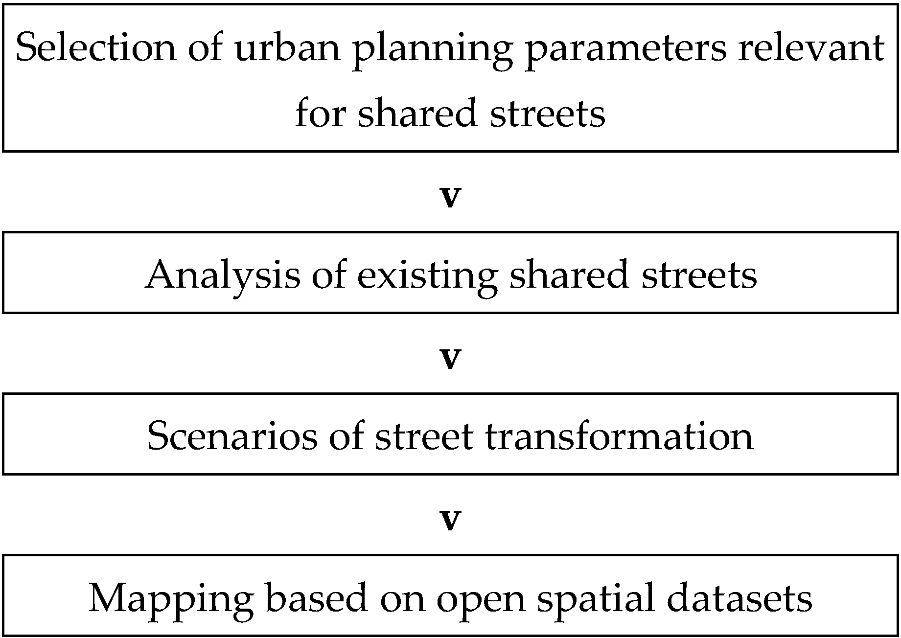
  • The first part of the research aims to identify the key urban planning parameters that are perceived as significant in the street transformation process. It is also important that the identified parameters are be expressed in the quantitative form and described by using the available open spatial datasets.
  • After the identification of the key parameters, the aim of the research is to define their values or value ranges. This is realised through the analysis of the existing shared streets.
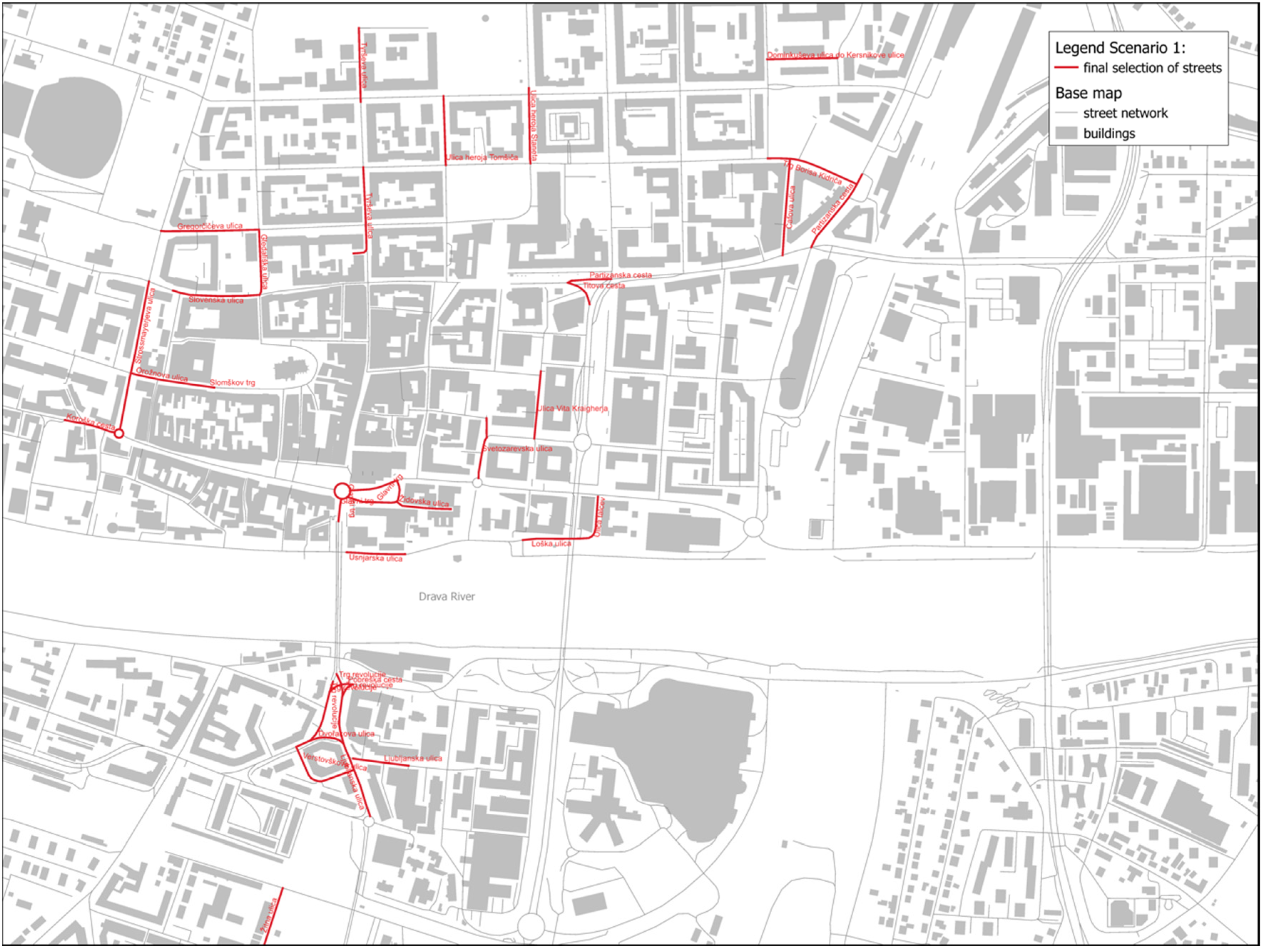
  • The final step of the research is to produce a readable map of the resulting street selection, which is based on the analysis of open spatial data in the GIS application. A step-by-step analysis approach was designed to provide insight into the impact of the criteria on the selection process.
  • The results in the form of street selection constitute a concrete and information-based initiation stage in a broader verification and selection process.

2. Materials and Methods

This paper used a methodology consisting of several steps (Figure 1). A more detailed description of the individual steps can be found below.

2.1. Selection of Urban Planning Parameters

As a framework for the research, the urban planning literature and the literature on shared spaces were reviewed, and urban planning parameters were selected and defined based on both (Section 3.2). They provide a relevant qualitative framework for mapping and identifying the transformation potential of a street. The initial selection of about 30 parameters was narrowed down to a total of 20 parameters grouped into five main categories.

2.2. Method for the Analysis of Existing Shared Streets

After the urban planning parameters were selected, they were supplemented with the values from the analysis of the existing shared streets in Central Europe. Streets were selected within urban areas, as the settlement patterns in villages are specific and different from those in urban settlements. In the preliminary review of the selected cases, it was found that, for example, a commercial shared space can be a highlighted flagship project in a metropolis and an articulation of the commercial street in the periphery of the same city. In this regard, our analysis excluded the highlighted (unique) flagship shared space projects and focused more on the ‘generic’ examples from which more averages and general ‘data’ can be discerned. An example of this is Mariahilfer Straße in Vienna, an approximately two km long commercial shared street that is five times the average length of an ordinary commercial shared street. In this respect, it was decided to avoid such flagship projects, as they usually do not to represent the average spatial conditions, but rather the extremes. In addition, the streets used in the analysis were known to the authors of this paper or mentioned in the literature or published on official websites as representing shared streets. They were divided into two categories—commercial shared streets and residential shared streets. In order to set the values for the selected urban planning parameters, a total of 30 existing shared streets were analysed. For their quantitative and qualitative analysis, Google Earth Pro with Street View and history view function was used.

2.3. Method for Scenario Development

To develop the criteria for selecting streets in urban environments, which are suitable for transformation into shared streets, it was decided to develop distinctive scenarios that could help to identify specific types of streets. This was considered important, since there are different street typologies in cities [21], which are embedded in numerous specific urban or spatial contexts. Therefore, two characteristic scenarios were formulated that formed the basis for the subsequent step—the application of the open spatial datasets. The scenarios cover two typical but different uses of buildings along the street—a commercial shared street and a residential shared street.

2.4. Open Spatial Datasets

Urban environments are too large and too complex for an efficient analysis and for decision-making. The human mind is limited by capacity, cognitive biases, and by the number of variables it can process simultaneously [48]. Open geospatial datasets, such as the OpenStreetMap (OSM), used under the terms of the Open Data Commons Open Database License (ODbL) set by the OpenStreetMap Foundation (OSMF), provide a rich data source for the study of urban structures and dynamics [49,50].
All spatial data used in this article can be accessed through the OSM platform. In addition, data about other cities can be retrieved, and the proposed methodology can be used to analyse public streets, allowing for a location-independent approach.
Spatial datasets describe urban space in a quantifiable way, independently of the subjective qualitative descriptions often used by urban planners and architects, but with the goal of enabling more robust, evidence-based urban planning and decision-making in the preliminary stages of urban planning and in the policy-making stages. Therefore, the proposed use of open spatial datasets has the following specific objectives: (i) an analysis method based on open data, which can be easily replicated and adopted; (ii) evidence-based results; and (iii) the ability to efficiently analyse a large number of streets and identify a limited number of relevant instances.
The datasets used in the paper include the transport network dataset, the building dataset, and the amenities dataset, which contain geometry data and a list of relevant attributes of the observed urban environment. All descriptions and values contained in the datasets were organised according to the structure described in the OSM wiki. The geographical area contained in the OSM datasets includes several districts in Maribor, Slovenia (Maribor has population of about 100,000 inhabitants and is the second-largest city in Slovenia). The geometry data and individual values were accessed and analysed using the QGIS software.
OSM geospatial datasets are a collaborative mapping effort, and some reliability and accuracy limitations have to be considered when using them. Several papers detail the reliability of OSM data when used in research [51,52]. From the perspective of the case study presented in this paper, the impact of missing or inaccurate data in the OSM datasets is limited, potentially resulting in some streets missing from the final selection. Alternatively, official public or commercial datasets could be used with no impact on the proposed methodology. For the presented research OSM datasets represent the most universal and replicable source of geospatial data.

3. Results

The initial question related to this research was whether we can identify urban planning parameters that can help us to identify streets that have the potential to become shared streets—this includes both commercial and residential shared streets. The results are presented below in four sections.

3.1. Urban Planning Parameters

After reviewing the relevant literature and previewing the existing examples of shared streets, a list of urban planning parameters was formulated (Table 1). According to the literature, some of them serve as positive or decisive preconditions for transformation, while others have a rather non-decisive influence on the transformation potential. Parameters with the evaluated negative influence are important for eliminating streets that are not suitable for transformation for obvious reasons—as is the case with, e.g., streets in industrial areas, high-end streets, and street sections with accesses to multi-storey car parks with high parking volume. Parameters related to elements of infrastructure, greenery, and urban furniture, which could also have an impact (e.g., pedestrian crossings, bike racks, artwork, seating, trees, and public street lighting) and would thus increase the complexity of the research, were excluded.
The five categories were formulated as follows: (1) building use; (2) location; (3) building typology; (4) street geometry; and (5) traffic infrastructure. The focus was on urban planning parameters and spatial attributes, which constitute the typology of a street as an open public space (Table 1). According to Lopes, “the creation of meaningful typological descriptions is essential in capturing desired qualities trapped in the urban structure, and so is their classification” [53].
Building use (1) was selected as the first general category for shared street transformation potential. Three parameters were selected for building uses connected to uses where shared streets are common, i.e., buildings of residential use (woonerfs), in areas with commercial activities held on ground floors of buildings, and in streets with important public buildings (schools, museums, etc.).
Building use is a very general category that in itself says nothing about the suitability for transformation into shared space, although it is considered one of the most important categories. On the official website for shared streets in Austria [54], typical building use is associated with typical locations for shared streets, i.e., (a) residential use (Wohnen); (b) commercial use/centrality (Geschäfts-Zentrenbereich); (c) old city centre (Altstadt); (d) public transport nodes (Verkehrsknotenpunkte ÖV); (e) education, schools, social (Bildung/Schulen/Soziales); and (f) squares (Platzsituationen). The Swiss recommendations identify “living/residential quarters (Wohnquartier), streets with shops (Geschaftsquartier), in a square, in the village center (Altstadt), next to the school (Schule) or at the station square (Bahnhofplatz)”, as uses and locations suitable for shared space [55]. Several sources explicitly emphasise the importance of ground floor uses as key to activating urban life on streets [56]. According to the London Department of Transport, “Shared space is often applicable where the buildings fronting the street have a strong heritage or cultural significance. It is particularly suitable where the quantity and type of surrounding land-use generates a high level of pedestrian demand for uses other than simply movement through the space” [57].
The second category, location (2), indicates whether the observed street is connected to commercial activities and related amenities, or is located near public squares, pedestrian zones, parks, and also adjacent to water elements (canal and river). Because of a usually high density of commercial activities and different points of interests that attract many pedestrians and are associated with often narrower streets that do not provide the required traffic separation for all users, many shared streets are nowadays located in historic city centres [54,55]. This also applies to smaller town centres and even villages, as is evident in many cases in Austria and Switzerland (although these are not the focus of this study). The entrances to museums and galleries, theatres, churches, and similar public buildings (1.1) can be an important location where more people can be expected on the street. For points of interests related to commercial uses on the ground floor of buildings (including cafés and restaurants for outdoor dining, ice cream vendors, stores, and others), an additional criterion was set: the number of entrances per 100 m. In a study on active and passive façades by Gehl and Svarre [17], an assumption was proven: there are more activities held in front of ground floor façades with open and varied character than there are in front of those that are closed. In the case of the ‘active façades,’ an average of 15–20 doors per 100 m are required, while in the case of the ‘friendly façades,’ which still contain relatively small units, the requirement is 10–14 doors per 100 m [17].
For the third category, the building typology, patterns within urban morphology were taken into consideration. Although many parameters could be selected in detail, two general types were recognised. The first is classified as the ‘continuous’ type, also referred to as the ‘area with continuous building frontages’ [58] or the situation of buildings with ‘continuous street-level storefronts’ [59], which forms an impermeable linear gesture along the street, and refers to compact attached single-family housing patterns in residential environments, particularly in areas of historic city centres. The second parameter is classified as the ‘discontinuous’ type, with predominantly isolated individual buildings or smaller clusters along the street; this refers to the typological classification of detached and semi-detached single-family houses and is also applicable to other uses.
The fourth category is related to the physical attributes of streets and is called street geometry (4). The selected parameters are the width of the street (the minimum width and the predominant width, measured between the buildings on both sides of the street or between the built borders, fences, etc.); the length of the entire shared street with indicated length of the minimum and maximum length of the street segment, as longer streets can have interruptions at the crossroads or at the lateral street connections (important for QGIS); and the height of buildings along the street, expressed as the predominant number of storeys. These attributes are considered important because it is often claimed in the literature that the lack of available space (related to the width of a street between buildings) is one of the reasons why conventional traffic separation into lanes for motorised traffic, cycle lanes, and pavements is not possible, and why a shared street can be seen as a better alternative also in terms of other benefits of placemaking [21]. NACTO defines two examples of residential street transformations into shared streets with the proposed widths of 9 and 10 meters, and two examples of commercial street transformations with the proposed widths of 12 and 14 meters [21] (these widths are proposed for streets in American cities that are on average larger than in European cities).
The fifth category, the traffic infrastructure (5), refers to the selected parameters related to street infrastructure supporting motorised traffic. The first parameter, i.e., the street classification, is considered an important criterion for street transformation [43]; however, as noticed in some cases of existing shared streets, it is not always the decisive criterion (‘Slovenska cesta’ in Ljubljana, Slovenia, was one of the major traffic arteries running through the city before being transformed into a shared street). Additionally, the entrances to multi-storey car parks and parking spaces were observed in connection to the examined streets. Large multi-storey car parks and open parking spaces are assumed to result in a higher traffic volume on the street, so they can be seen as a negative influence on the decision to transform a street into a shared street. Lastly, transit was observed, particularly bus stops, as larger buses can pose a threat to pedestrians. As stated, “the connectivity with the public transportation network is an important factor for a successful shared street design. However, this does not mean that the buses or trams should use the shared street as part of the route” [28]. It is suggested that a street can be well-connected with the public transport system for it to be pedestrian-friendly in terms of reduced vehicular movement.

3.2. Analysis of the Existing Shared Streets

To refine the characteristic urban planning parameters for shared streets, 30 existing shared streets in Central Europe were selected and analysed. Each street is represented by the observed values in Table 2.
In the analysis of commercial shared streets (Table 2), it was found that they have predominantly commercial ground floor use. There may be public buildings along the street as well, but according to the research of the selected cases, it may not be a decisive criterion. Furthermore, most of the analysed shared streets serve as an outdoor space connected to the building use on the ground floor and, in almost all observed cases, they were connected or they led to a public square and/or pedestrian zone. The connection to the park and to bodies of water was not recognised as an important criterion. The commercial shared streets are usually established on streets with predominantly continuous building structure at least on one side of the street, while the width of the streets, measured as a distance between buildings of both street edges, varies. In compact old city centres, streets may be very narrow, while the majority of commercial shared streets are 13–25 m wide with the narrowest parts ranging from 6–8 m. The total length of the selected and analysed streets also varies. Most of them are 100–300 m long, while the length of the segments of the streets between crossroads is in the range of 50–220 m, with an average minimum length of approximately 105 m and an average maximum length of 145 m.
Nevertheless, the research shows that the predominant height of the buildings along commercial shared streets is 3–5 storeys. The parameters related to the existing traffic infrastructure show that the entrances to multi-storey car parks were noticed on the observed shared streets, although data on the number of the available parking spaces were not acquired. The presence of parking spaces was noticed on almost half of the observed streets. The research also shows that quite a few of the transformed streets had parking space before the transformation into a shared street, with the parking space being later abandoned. Although streets with public transport (i.e., larger buses) may be less suitable to be transformed into shared streets [28], the research of the selected shared streets shows the opposite—there is public transport on almost half of the analysed commercial shared streets.
In the analysis of residential shared streets (Table 3), it was found that they have predominantly residential ground floor use. Public buildings and points of interest, public squares, pedestrian zones, parks, or water elements connected to the analysed residential shared streets are rare and can be taken as non-decisive criteria. The residential shared streets are equally established, both on streets with predominantly continuous and those with discontinuous building structure. The width of the streets, measured as a distance between buildings or built edges, fences, etc., is between 5 and 15 m. The total length of the selected and analysed streets also varies. Most of them are 100–300 m long, while the length of the segments of the streets between crossroads is in the range of 40–280 m with an average minimum length of approximately 95 m and an average maximum length of 125 m. The total length of the street can also indicate a network of streets with the same name, which comprise an area of connected and uninterrupted shared streets.
The research shows that the predominant height of the buildings along residential shared streets is 2–4 storeys. Nevertheless, this value does not exclude shared streets in higher density neighbourhoods with higher buildings. The parameters related to the existing traffic infrastructure show that the multi-storey car parks and public transport are rare on the analysed shared streets, while the presence of parking spaces was noticed on almost all of the observed streets before and after the transformation into shared streets.

3.3. Test Scenarios (Search Engine for Shared Streets)

Two distinctive scenarios were developed using parameters and additional values derived from the analysis of the existing shared streets. The first scenario seeks a typical commercial street (Table 4), while the second one seeks a typical street in a low-rise residential area (Table 5).

3.4. Results of the GIS Analysis

In the final part of the research, the predefined scenarios and associated street characteristics were used in the analysis of the OSM geospatial data to identify streets with a high transformation potential.

3.4.1. Identification of the Proposed Commercial Shared Streets

The analysis according to Scenario 1 identified streets defined as commercial streets in Maribor, Slovenia. Two general analysis steps were used to isolate or eliminate streets and street segments that met or did not meet the predefined criteria for a commercial shared street. The first step was to isolate all streets that met the following criteria: (1) a high number of amenities, such as stores, restaurants, bars, and post offices, indicates the possibility of shared street transformation potential in the vicinity (concentration shown as a blue heat map); (2) buildings with amenities and central function are shown in red (Figure 2), with the exception of kindergartens, schools, and universities, as these building types represent a separate shared street type that was not addressed in this paper. Streets located in the indicated areas were identified as streets with a possible transformation potential.
The second step of the analysis involved three criteria: (1) the relevant length of streets and street segments (purple and blue segments correspond to the predefined criteria); (2) the relevant height of buildings on the observed street, represented by the number of stories of the building; and (3) the width of streets, represented by the distance between the centerline of the street and the building façade, highlighted in green if adequate or yellow if inadequate (Figure 3). In the final step of the analysis, a negative selection was performed, excluding all streets and street segments located in areas that did not meet the predefined criteria. The final figure shows all identified streets and street segments with potential for transformation into commercial shared streets (Figure 4).
As expected, the number of identified segments was significantly lower than in the residential type presented in the following section. A total of 68 street segments were identified, most of which are located on the outskirts of the existing pedestrian zone in the historic city centre and in the vicinity of strong functional centres of the city (marketplace, etc.).

3.4.2. Identification of the Proposed Residential Shared Streets

The analysis according to Scenario 2 identified streets described as residential shared streets in Maribor, Slovenia. The three-step analysis was used to isolate or eliminate streets and street segments that met or did not meet the predefined criteria for a residential shared street. The first step was to isolate all streets that met the following criteria: streets are classified as residential or tertiary (i.e., OSM key: highway = residential or tertiary). Subsequently, the isolated streets and street segments were visualised on the map in relation to their length, with sections that were too short coloured green and sections that were too long coloured yellow (Figure 5).
In a second step, the use of buildings located along the observed streets was analysed. Buildings with incompatible uses were shown in red, and the corresponding streets were eliminated. At the same time, building heights, represented by the number of stories of the building, were shown in shades of blue to indicate streets and street segments that were adjacent to taller buildings. Such buildings were also eliminated (Figure 6).
The third step was to evaluate the impact of surrounding amenities, with a small number of amenities, such as stores, restaurants, bars, and post offices, expected to be found on residential shared streets. Streets in areas with a large number of such amenities were excluded from the selection (Figure 7).
Finally, the remaining streets and street segments that met all the criteria of the proposed transformation scenario for residential shared streets were shown on the map (Figure 8).
The final selection of streets and street segments is broadly consistent with the expected locations and high number of occurrences. In the observed area, 459 street segments were identified as streets with potential for transformation into residential shared streets.
As a conclusion from the GIS analysis, it can be stated that the proposed selection method has largely led to the expected results, which are very relevant and can also be confirmed based on the authors’ knowledge of the urban area. The method presented is not intended to be a final decision tool, but rather serve as a test tool for experts, planners, decision-makers, and the interested professional public to allow them to have an idea of the possibilities for future street transformations.

4. Discussion

The paper addressed the specific topic of the transformation potential of shared streets seen from an urban planning perspective. The methodology of the multi-step analysis focused on the typologies of shared streets, which emphasise the place dimension of the street, and examined whether this concept could be a suitable alternative to traditional street layouts. This approach is significant as most research studies on shared space focus on traffic-related issues, especially traffic safety [27,30]; the urban design aspects of shared streets are also well researched and described [23,28,34]. However, the urban planning context of shared streets is usually only briefly mentioned and not adequately elaborated [26,32]. The research presented in this paper helps to fill this gap, while adding, in the context of approaches and tools employed for the transformation of streetscapes [20], to a list of possible ways of dealing with city spaces that can be transformed into more sustainable environments in the city.
Regarding the first research question, the study defined and described a list of urban planning parameters that influence the suitability of streets for transformation, while the analysis of existing shared streets across Central Europe provided a framework for defining the values of the selected parameters. One of the most important steps of the research was the application of the multiplicity of criteria with decisive and non-decisive parameters for the definition of complex urban typologies. In this context, building use, for example, is considered as a very general category. It is only one of the multiple criteria and does not reveal enough about the suitability for transformation into a shared street—only in combination with other parameters can building use influence the decision on transformation. The basic urban planning parameters, such as the use of the buildings and the length and the width of the street, help us to better understand the urban fabric in which the street spaces acquire new functions. It is necessary to understand the new paradigm of street design, which is deeply rooted in urban structures and is related to the different uses and activities these structures trigger. However, the importance of conventional transport and traffic planning parameters and analyses is not considered less important. It is assumed that the data on, for example, traffic flows can be obtained in a later step of the process when the street transformation potential derived from the urban planning parameters has already been identified.
The second research question was related to the recognition of selected urban planning parameters in the existing open-source datasets. It can be concluded that the presented method allows for the simultaneous analysis of a large number of streets in the city and that it identifies potential streets for transformation. These can be additionally analysed in later stages of the decision-making process (e.g., economic considerations).
In the broader context, the representational potential of mapping was used in the paper to illustrate the unseen or unimagined potential of streetscape transformations at the city scale. The immediacy and accessibility of maps can help urban planning authorities to analyse the scope and transformation potential of existing streets in the city. The GIS-related data presentation, meanwhile, can take wider territories into consideration and broaden the perspective on evolution of shared space [26], focusing not on individual streets but on larger areas or even parts of cities. The proposed use of maps also demonstrates the production of spatial knowledge as described by Dovey and Ristic [60], with the common use of GIS dealing primarily with geographic knowledge representation and, less commonly, with urban design. In this sense, the presented mapping of the transformation potential of streets shows the representation of an existing city, while disclosing hidden potentials and possibilities, enabling us to see the observed territories, areas, and the city in new ways [45,60].
In future, a further analysis of transformation scenarios could be carried out in relation to streets with more detailed parameters, e.g., near schools, kindergartens, and universities. Some parameters and their values (such as distance to multi-storey car parks or number of parking spaces) would require more in-depth analysis and more data on how they affect transformation scenarios. On the other hand, when it comes to streets located in congested commercial areas, as well as in many anonymous residential streets without an adequate infrastructure for pedestrians and cyclists, many already function as shared streets. In this regard, it is important that municipalities or communities recognize this potential, as it could lead to more activity in the streets and simplify administrative procedures for playing or picnicking in the streets, etc., as proposed by the NACTO Global Street Design Guide [21]. However, the study did not intend to force the proposed street transformation for its own sake. An initiative for shared space should come from local communities (bottom-up), with a corresponding need coming from either residents or business owners as well [47,55].
The results of the research based on the case study in the city of Maribor show that the selected urban planning parameters helped to identify streets with transformation potential. In the case of Maribor, the implementation of shared streets is a relatively new approach, due to its late adoption in national legislation, as the first commercial shared street was opened in 2019 (Cafova Street, followed by Koroška Street in 2020) [61]; one shared street is under construction (Gregorčičeva Street), and several others are in the planning phase. The research results presented in this paper could support further discussions and planning at the municipal level, namely, because they could expand the proposed scope of streets to be transformed into shared streets. This result is especially true for residential streets as a new master plan for the city is currently being adopted.
Above that, the quantitative and data-driven methodology presented in the paper was designed, with transferability being the key feature. The analysis of the existing shared streets included multiple cities and other urban agglomerations to produce the universal features of shared streets. Most important, the OSM datasets were used to make the analysis process easily reproducible, and the relevance of the method proposed verifiable. We therefore understand that, wherever shared streets are being considered as a spatial intervention, the use of the presented methodology will provide important insights.
With the ambition to transform streets into the ultimate social space [7,8,9,10,11,12,13,14], the differentiation between types of streets [21] has been manifested in the research. While the potential transformation of both commercial and residential streets into shared streets would enhance their place function, their characters are different. In order to expand on mapping them in relation to the complexity of the city, the spatial relationships and proximities among commercial, residential, and other types of (possible) shared streets can be encouraged in further research. With the idea of sustainable city mixed use development in the city of places [42], the perspective of urban planning and design should take a prominent role in interdisciplinary projects. Such endeavours will encourage streets to once again become important living spaces, especially when issues of urban growth and sustainability requirements must find a common response.

Author Contributions

Conceptualization, K.P., P.Š. and A.Ž.; methodology, K.P., P.Š. and A.Ž.; validation, K.P., P.Š. and A.Ž.; formal analysis, A.Ž.; investigation, P.Š.; writing—original draft preparation, K.P. and P.Š.; writing—review and editing, K.P., P.Š. and A.Ž.; visualization, A.Ž.; supervision, K.P. All authors have read and agreed to the published version of the manuscript.

Funding

This research received no external funding. The APC was funded by the Erasmus + project KA2—Higher education strategic partnerships no. 2018-1-RO01-KA203-049214, “Rehabilitation of the Built Environment in the Context of Smart City and Sustainable Development Concepts for Knowledge Transfer and Lifelong Learning”—RE-BUILT.

Institutional Review Board Statement

Not applicable.

Informed Consent Statement

Not applicable.

Data Availability Statement

All research data were sourced from openstreetmap.org (accessed on 17 April 2022), accessed directly using QGIS software and the QuickOSM plugin (https://plugins.qgis.org/plugins/QuickOSM/), (accessed on 17 April 2022).

Conflicts of Interest

The authors declare no conflict of interest.

References

  1. Palacký, J.; Wittmann, M.; Františák, L. Evaluation of Urban Open Spaces Sustainability. In Proceedings of the 29th Annual AESOP 2015 Congress Definite Space—Fuzzy Responsibility, Prague, Czech Republic, 13–16 July 2015; pp. 701–715. [Google Scholar]
  2. Mehta, V. The Street: A Quintessential Social Public Space, 1st ed.; Routledge: New York, NY, USA, 2013. [Google Scholar]
  3. Lydon, M.; Garcia, A. Tactical Urbanism: Short-Term Action for Long-Term Change; Island Press: Washington, DC, USA, 2015; ISBN 9781610915267. [Google Scholar]
  4. European Commision. Reclaiming City Streets for People: Chaos or Quality of Life? Publication Office of European Commission: Luxembourg, 2004. [Google Scholar]
  5. NACTO. Urban Street Design Guide; Island Press: New York, NY, USA, 2013. [Google Scholar]
  6. EC. Stepping Up Europe’s 2030 Climate Ambition Investing in a Climate-Neutral Future for the Benefit of Our People; European Commission: Luxembourg, 2020; Volume 53. [Google Scholar]
  7. Jacobs, J. The Death and Life of Great American Cities, 1st ed.; Random House: New York, NY, USA, 1961; ISBN 9780679741954. [Google Scholar]
  8. Cullen, G. Townscape; The Architectural Press: London, UK, 1961. [Google Scholar]
  9. Anderson, S. (Ed.) On Streets: Streets as Elements of Urban Structure, 1st ed.; MIT Press: Cambridge, MA, USA, 1978. [Google Scholar]
  10. Rowe, C.; Koetter, F. Collage City; MIT Press: Cambridge, MA, USA, 1978. [Google Scholar]
  11. Appleyard, D. Livable Streets; University of California Press: Los Angeles, CA, USA, 1982. [Google Scholar]
  12. Moudon Vernez, A. (Ed.) Public Streets for Public Use; Book News Inc.: Portland, OR, USA, 1897. [Google Scholar]
  13. Çelik, Z.; Diane, F.; Richard, I. (Eds.) Streets: Critical Perspectives on Public Space, 1st ed.; University of Callifornia Press: Los Angeles, CA, USA, 1996. [Google Scholar]
  14. Jacobs, A.B. Great Streets; MIT Press: Cambridge, MA, USA, 1995. [Google Scholar]
  15. Gehl, J. Cities for People; Island Press: Washington, DC, USA, 2010. [Google Scholar]
  16. Loukaitou-Sideris, A.; Ehrenfeucht, R. Sidewalks: Conflict and Negotiation over Public Space; MIT Press: Cambridge, MA, USA, 2009. [Google Scholar]
  17. Gehl, J.; Svarre, B. How to Study Public Life; Island Press-Center for Resource Economics: Washington, DC, USA, 2013; ISBN 9781610915250. [Google Scholar]
  18. Carmona, M. Contemporary public space: Critique and classification, Part one: Critique. J. Urban Des. 2010, 15, 123–148. [Google Scholar] [CrossRef]
  19. Moughtin, C. Urban Design: Street and Square, 3rd ed.; Routlege: New York, NY, USA, 2003. [Google Scholar]
  20. Pogačar, K.; Šenk, P. Alternative approaches and tools for the transformation of streetscapes direct physical interventions and different modes of participation. Prostor 2018, 26, 170–183. [Google Scholar] [CrossRef]
  21. NACTO. Global Street Design Guide; Global Designing Cities Initiative, Ed.; Island Press: New York, NY, USA, 2016. [Google Scholar]
  22. Menino, T.M.; Tinlin, T.J. Boston Complete Streets: Design Guide; City of Boston: Boston, MA, USA, 2013.
  23. McKenna, D. Designing Shared Space; Odell, S., Ed.; Landscape Institute: London, UK, 2019; Volume 5. [Google Scholar]
  24. Hamilton-Baillie, B. Towards shared space. Urban Des. Int. 2008, 13, 130–138. [Google Scholar] [CrossRef]
  25. Ben-Joseph, E. Changing the residential street scene—Adapting the shared street (Woonerf) concept to the suburban environment. J. Am. Plan. Assoc. 1995, 61, 504–515. [Google Scholar] [CrossRef]
  26. Karndacharuk, A.; Wilson, D.J.; Dunn, R. A Review of the Evolution of Shared (Street) Space Concepts in Urban Environments. Transp. Rev. 2014, 34, 190–220. [Google Scholar] [CrossRef]
  27. Karndacharuk, A.; Wilson, D.J.; Dunn, R.C.M. Safety performance study of shared pedestrian and vehicle space in New Zealand. Transp. Res. Rec. 2014, 2464, 1–10. [Google Scholar] [CrossRef]
  28. Jayakody, R.R.J.C.; Keraminiyage, K.; Alston, M.; Dias, N. Design factors for a successful shared space street (SSS) design. Int. J. Strateg. Prop. Manag. 2018, 22, 278–289. [Google Scholar] [CrossRef]
  29. Imrie, R. Auto-disabilities: The case of shared space environments. Environ. Plan. A 2012, 44, 2260–2277. [Google Scholar] [CrossRef]
  30. Anvari, B.; Bell, M.G.H.; Sivakumar, A.; Ochieng, W.Y. Modelling shared space users via rule-based social force model. Transp. Res. Part C Emerg. Technol. 2015, 51, 83–103. [Google Scholar] [CrossRef] [Green Version]
  31. Anvari, B.; Bell, M.G.H.; Angeloudis, P.; Ochieng, W.Y. Calibration and validation of a shared space model: Case Study. Transp. Res. Rec. 2016, 2588, 43–52. [Google Scholar] [CrossRef] [Green Version]
  32. Hamilton-Baillie, B. Shared space: Reconciling people, places and traffic. Built Environ. 2008, 34, 161–181. [Google Scholar] [CrossRef] [Green Version]
  33. Hamilton-Baillie, B. Urban design: Why don’t we do it in the road? Modifying traffic behavior through legible urban design. J. Urban Technol. 2004, 11, 43–62. [Google Scholar] [CrossRef]
  34. Biddulph, M. Radical streets? The impact of innovative street designs on liveability and activity in residential areas. Urban Des. Int. 2012, 17, 178–205. [Google Scholar] [CrossRef]
  35. Singh, S.; Nikhil, A.; Surendra, Y. Review on Key Elements of Traffic & Transportation Planning Approachs for a Mid-Sized City. In Proceedings of the 10th International Conference on Recent Development in Engineering Science, Humanities and Management, Candagarh, India, 24 December 2017; pp. 86–95. [Google Scholar]
  36. Jones, P.; Boujenko, N.; Marshall, S. Link & Place: A Guide to Street Planning and Design; Landor Press: London, UK, 2007. [Google Scholar]
  37. Jones, P.; Boujenko, N. “Link” and “Place”: A New Approach to Street Planning and Design. In Proceedings of the 32nd Australasian Transport Research Forum (ATRF), Auckland, New Zealand, 29 September–1 October 2009. [Google Scholar]
  38. Smithson, A.; Smithson, P. Architectural Design Magazine; The Standard Catalogue Company: London, UK, October 1958; pp. 385–388. [Google Scholar]
  39. Casey, E.S. The Fate of Place: A Philosophical History, 1st ed.; University of California Press: Los Angeles, CA, USA, 1997. [Google Scholar]
  40. Arendt, H. The Human Condition; University of Chicago Press: Chichago, IL, USA, 1958. [Google Scholar]
  41. Turner, V.W. The Ritual Process: Structure and Anti-Structure; Aldine Publishing: Chicago, IL, USA, 1969. [Google Scholar]
  42. Jones, P.; Marshall, S.; Boujenko, N. Creating more people-friendly urban streets through “link and place” street planning and design. IATSS Res. 2008, 32, 14–25. [Google Scholar] [CrossRef]
  43. Gerike, R.; Koszowski, C.; Schroter, B.; Wittwer, R.; Weber, J.; Dean, M.; Jones, P. Urban Corridor Road Design: Guides, Objectives and Performance Indicators. 2019. Available online: https://www.roadspace.eu/results/better-streets-for-better-cities (accessed on 17 April 2022).
  44. Jones, P.; Anciaes, P.R.; Buckingham, C.; Cavoli, C. Urban Mobility: Preparing for the Future, Learning from the Past—CREATE Project Summary and Recommendations; Landor LINKS: London, UK, 2018. [Google Scholar]
  45. Corner, J. The Agency of Mapping: Speculation, Critique and Invention. In The Map Reader: Theories of Mapping Practice and Cartographic Representation; John Wiley & Sons, Ltd.: New York, NY, USA, 2011; pp. 89–101. [Google Scholar] [CrossRef]
  46. Cosgrove, D. Introduction: Mapping Meaning. In Mappings; Cosgrove, D., Ed.; Reaktion Books: London, UK, 1999; pp. 1–23. [Google Scholar]
  47. Šenk, P.; Pogačar, K. Tracking Contemporary Streetscape Transformation Processes—Two Case Studies from Slovenia Sledovanie aktuálneho procesu transformácie ulíc—dve prípadové štúdie zo Slovinska. Archit. A Urban. 2019, 1–2, 60–73. [Google Scholar]
  48. Halford, G.S.; Baker, R.; McCredden, J.E.; Bain, J.D. How many variables can humans process? Psychol. Sci. 2005, 70–76. [Google Scholar] [CrossRef] [PubMed]
  49. Jiang, B.; Yao, X. (Eds.) Geospatial Analysis and Modeling of Urban Structure and Dynamics: An Overview; Springer: New York, NY, USA, 2010; Volume 99, ISBN 0924-5499. [Google Scholar]
  50. Žižek, A. Alternative methods for data collection and usage analysis of public space. In Proceedings of the Turn Innovative Ideas into Reality, Maribor, Slovenia, 13 November 2018; pp. 84–95. [Google Scholar]
  51. Hashemi, P.; Ali Abbaspour, R. Assessment of logical consistency in OpenStreetMap based on the spatial similarity concept. In Lecture Notes in Geoinformation and Cartography; Springer: Berlin, Germany, 2015; pp. 19–36. [Google Scholar] [CrossRef]
  52. Basiri, A.; Jackson, M.; Amirian, P.; Pourabdollah, A.; Sester, M.; Winstanley, A.; Moore, T.; Zhang, L. Quality assessment of OpenStreetMap data using trajectory mining. Geo-Spatial Inf. Sci. 2016, 19, 56–68. [Google Scholar] [CrossRef] [Green Version]
  53. Lopes, J.V.; Paio, A.C.R.; Beirão, J.N.; Pinho, E.M.; Nunes, L. Multidimensional Analysis of Public Open Spaces. Urban Morphology, Parametric Modelling and Data Mining. In Proceedings of the 33rd eCAADe Conference, Vienna, Austria, 16–18 September 2015; pp. 351–360. [Google Scholar]
  54. Walk-Space.at—Der Österreichische Verein für FußgängerInnen Begegnungszonen in Österreich. Available online: http://www.begegnungszonen.or.at/ (accessed on 15 December 2021).
  55. Fussverkehr Schweiz. Available online: https://begegnungszonen.ch/ (accessed on 15 December 2021).
  56. Scheuvens, R.; Schütz, T. (Eds.) Perspektive Erdgeschoss. In Reihe Werkstattberichte; Magistratsabteilung 18 Stadtentwicklung und Stadtplanung: Wien, Austria, 2011; p. 304. [Google Scholar]
  57. Mukhopadhyay, A. A Shared Space? Great Britain: Department for Transport: London, UK, 2020; ISBN 9780115532092.
  58. Oliveira, V.; Silva, M.; Samuels, I. Urban morphological research and planning practice: A Portuguese assessment. Urban Morphol. 2014, 18, 23–39. [Google Scholar]
  59. Appolloni, L.; Corazza, M.V.; D’Alessandro, D. The pleasure of walking: An innovative methodology to assess appropriate walkable performance in urban areas to support transport planning. Sustainability 2019, 11, 3467. [Google Scholar] [CrossRef] [Green Version]
  60. Dovey, K.; Ristic, M. Mapping urban assemblages: The production of spatial knowledge. J. Urban. 2017, 10, 15–28. [Google Scholar] [CrossRef]
  61. Pogačar, K. Potentials and experience of streetscape transformations—Recent examples from Maribor. In Proceedings of the City Streets 4, Ljubljana, Slovenia, 23 September 2020; pp. 442–451. [Google Scholar]
Figure 1. Steps in the research process.
Sustainability 14 08563 g001
Figure 2. Commercial shared streets—impact of amenities on the street typology.
Sustainability 14 08563 g002
Figure 3. Commercial shared streets—impact of street length and building hight on the street selection.
Sustainability 14 08563 g003
Figure 4. Commercial shared streets—final identification of streets with possible transformation potential.
Sustainability 14 08563 g004
Figure 5. Residential shared streets—street classification and length analysis.
Sustainability 14 08563 g005
Figure 6. Residential shared streets—impact of building use and height on the street selection.
Sustainability 14 08563 g006
Figure 7. Residential shared streets—impact of amenities on the street selection.
Sustainability 14 08563 g007
Figure 8. Residential shared streets—proposed final identification of streets with transformation potential.
Sustainability 14 08563 g008
Table 1. List of the proposed urban planning parameters and other physical attributes relevant to the shared street evaluation.
CategoryParameters
(1) Building useResidential building
Commercial use (ground floor)
Public building
(2) Location (next to…)Points of interest (entrance)
Public square
Pedestrian zone
Park
Water (canal, river, etc.)
(3) Building typologyContinuous building structure
Discontinuous building structure
(4) Street geometryWidth of the street—predominant
Width of the street—minimum
Length of the shared street—total
Length of the shared street segment—minimum
Length of the shared street segment—maximum
Predominant building height (storeys)
(5) Traffic infrastructureStreet classification
Multi-storey car park
Parking spaces
Public transport network—bus stops
Table 2. Analysis of the existing commercial shared streets.
Parameters/Streets 1123456789101112131415
Residential buildingnnnyynnnnnnnnnn
Commercial useyyyyyyyyyyyyyyy
Public buildingnynnnnyyynyyyyy
Points of interest (entrance)yyyyyyyyyyynyyy
Public squareyyynnyyyyyyyyyy
Pedestrian zonen/ayn/ayyyyyyn/aynnyy
Parknnnnnnnnnnnynnn
Waternnnnnnnnnnnnnnn
Continuous building structureyyyyynnyyyyyyyy
Discontinuous building structurennnnnyynnnnnnnn
Width of the street—predominant (m)10131841419121325161116152624
Width of the street—minimum (m)812163615811201461361421
Length of the SS—total (m)9038050019020018014033020030050130300150350
Length of the SS segment—min (m)9060701909050140110200605013010015090
Length of the SS segment max (m)9015015019011013014022020014050130200150130
Predominant building height (storeys)444336544334435
Shared street classificationrl (r)l (r)l (r)l (r)l (r)l (r)r/tl (r)p (r)p (r)l (r)rrp (r)
Multi-storey car parknnynyynyn/aynnnn/an/a
Parking spacesnynnyyyynn/ayynyn/a
Public transport network—bus stopsnyynnynnynnnyny
1 Selected commercial shared streets: 1 Hans-Gasser-Platz, Villach (Austria); 2 Neuer Platz, Klagenfurt (Austria); 3 Landstraße, Linz (Austria), 4 Lederergasse, Linz (Austria); 5 Reschgasse, Vienna (Austria); 6 Alexanderstraße, Chur (Switzerland); 7 Schreinerstraße, St. Gallen (Switzerland); 8 Kirchstraße/Bettlachstraße, Grenchen (Switzerland); 9 třída Míru, Pardubice (Czech Republic); 10 Królewska, Kutno (Poland); 11 Plac Jana Pavla II, Swiebodzin (Poland); 12 Cafova ulica, Maribor (Slovenia); 13 Poljanska cesta, Ljubljana (Slovenia); 14 Ludwigplatz, Kelheim (Germany); 15 Stresemannstraße, Mönchengladbach (Germany). Legend: SS: shared street; y: yes; n: no; n/a: data not available; r: residential street; l: living street; p: pedestrian street; t: tertiary street; ( ): street classification before and after the shared street segment.
Table 3. Analysis of existing residential shared streets.
Parameters/Streets 1123456789101112131415
Residential buildingyyyyyyyyyyyyyyy
Commercial usennnnnnnnnnnnynn
Public buildingnynnnynnnynnnyn
Points of interest (entrance)nynnnynnnynnnyn
Public squarenynnnnnnnynnynn
Pedestrian zonennnnnnnnnnnnnnn
Parknnnnnynnnnyynnn
Waternnnnnnnnnnnnnnn
Continuous building structureynnyynynnnynnnn
Discontinuous building structurenyynnynyyynyyyy
Width of the street—predominant (m)815111171210577797610
Width of the street—minimum (m)7138116119566556510
Length of the SS—total (m)150140904012020015011060700330120810230200
Length of the SS segment min (m)1501409040120501501106014060405050200
Length of the SS segment max (m)1501409040120150150110602801006060180200
Predominant building height (storeys)5524843232442,422
Shared street classificationrrrl (r)ll (r)ll (r)rl (r)rrr (t)tl (r)
Multi-storey car parknnnnnnnnnnnnynn
Parking spacesyyynyyyyyyyyyny
Public transport network—bus stopsnynnnnnnnnnnnnn
1 Selected residential shared streets: 1 Wehrgasse, Vienna (Austria); 2 Lastenstraße, Salzburg (Austria); 3 Türkengasse, Tulln an der Donau (Austria); 4 Neuweg, Dübendorf (Switzerland); 5 Rue des Moulins-Raichlen, Geneva (Switzerland); 6 Bürenstrasse, Bern (Switzerland); 7 Luftmattstraße, Basel (Switzerland); 8 Beim Wasserturm, Basel (Switzerland); 9 Erlenweg, Bern (Switzerland); 10 Płatnicza, Warsaw (Poland); 11 Runkova ulica, Ljubljana (Slovenia); 12 Obirska ulica, Ljubljana (Slovenia); 13 Pohorska ulica, Maribor (Slovenia); 14 Vrazova ulica, Ljutomer (Slovenia); 15 Friedrichstraße, Haßloch (Germany). Legend: SS: shared street; y: yes; n: no; n/a: data not available; r: residential street; l: living street; p: pedestrian street; t: tertiary street; ( ): street classification before and after the shared street segment.
Table 4. Scenario 1—Commercial shared street.
CategoryParameterValue
Building useCommercial use 1Shops, restaurants, etc.
LocationPoints of interest10–15 entrances per 100 m
Building typologyContinuous building structure
Street geometryWidth of the street 2<20 m
Length of the street/segment<350 m
Building height3–5 storeys
Traffic infrastructureStreet classificationtertiary
1 Only ground floors are observed. 2 The width of the street equals the width of the space between buildings.
Table 5. Scenario 2—Residential shared street.
CategoryParameterValue
Building useResidential useIndividual houses
LocationPoints of interest1 entrance per 100 m 1
Building typologyDiscontinuous building structureLow density
Street geometryWidth of the street 2<12 m
Length of the street/segment<250 m
Building height<3 storeys
Traffic infrastructureStreet classificationResidential streets and ways
1 POI on the ground floor only as an exception. 2 Data on the width of the street are not available in GIS. Therefore, the distance between the plots or fences was considered.
Publisher’s Note: MDPI stays neutral with regard to jurisdictional claims in published maps and institutional affiliations.

