
Ruins and Remains as a Background: Natural Catastrophes, Abandonment of Medieval Villages, and the Perspective of Civilization during the 20th Century in the Central Apennines (Abruzzi Region, Central Italy)


Abstract
:1. Introduction
2. Materials and Methods
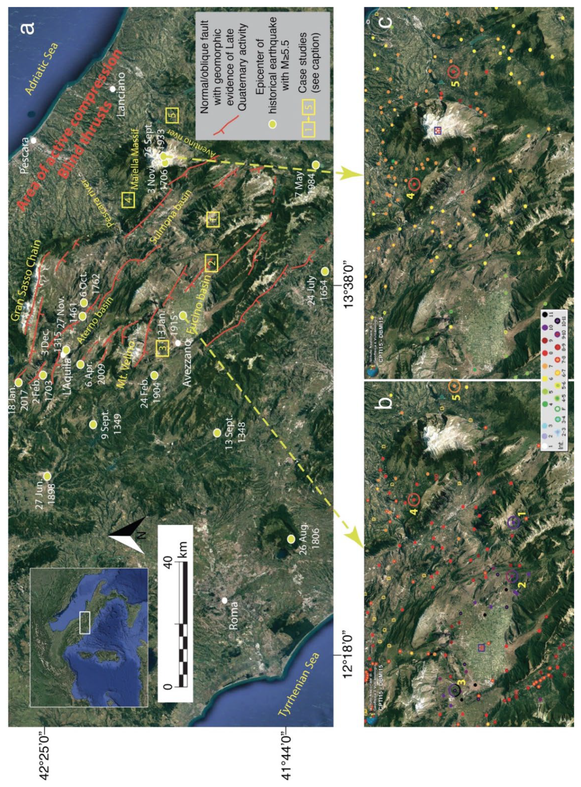
2.1. Research Area
2.1.1. Geological and Seismotectonic Framework
2.1.2. The 1915 and 1933 Earthquakes
2.2. Data Sources
3. Results
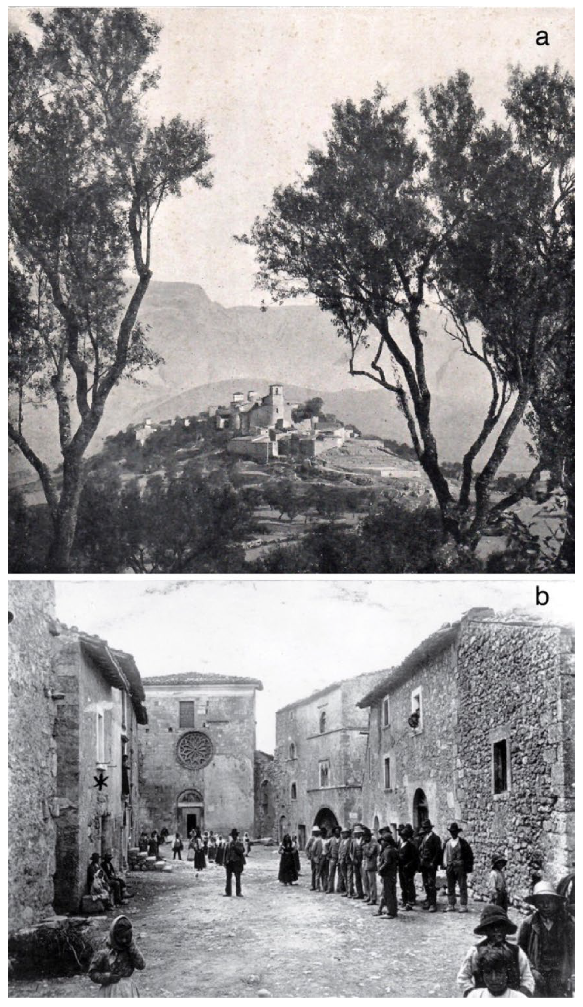
3.1. Frattura
3.1.1. Geomorphological and Geographical Frameworks
3.1.2. Abandonment and Resettlement of Frattura
3.1.3. Frattura Today
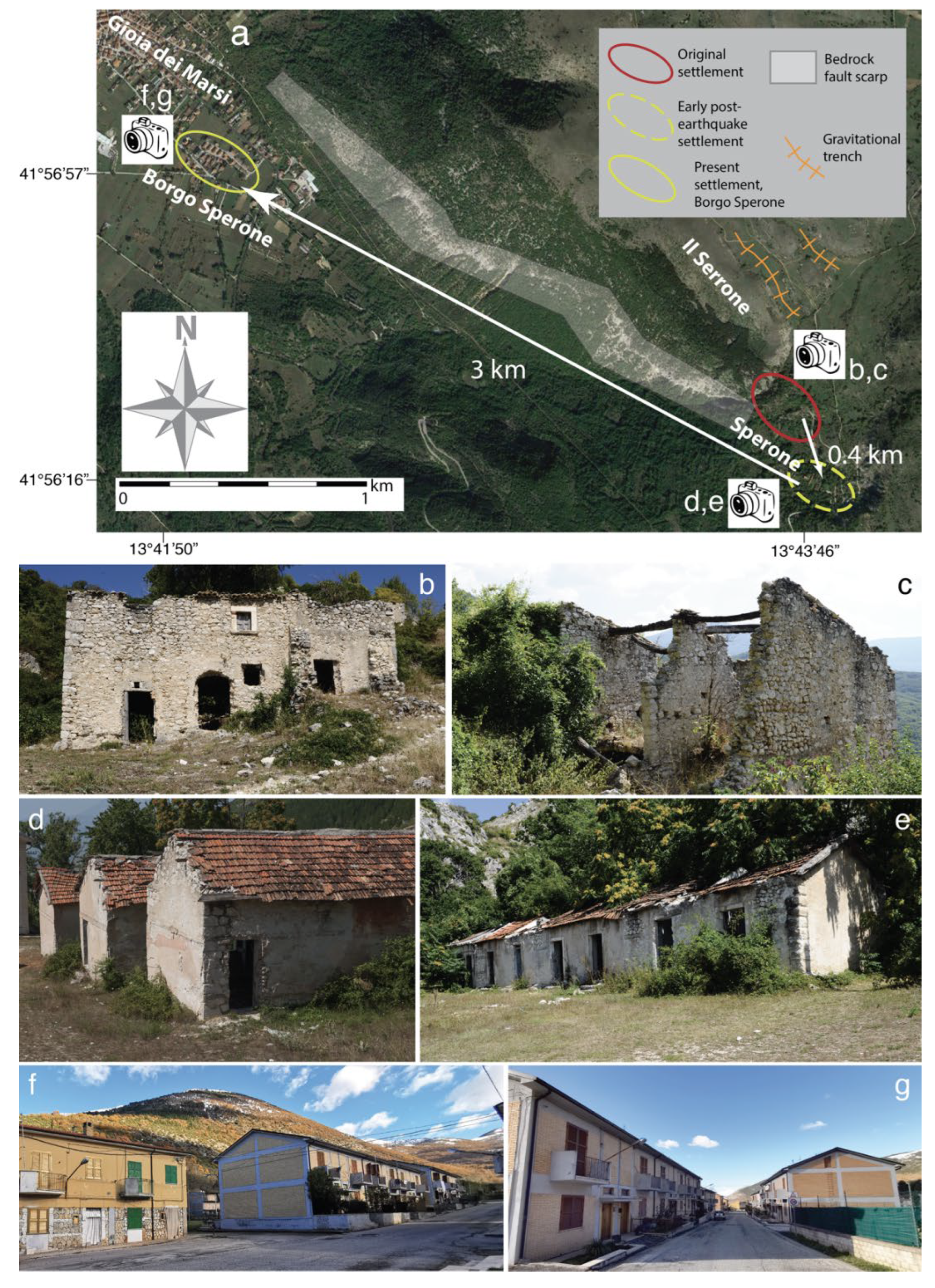
3.2. Sperone
3.2.1. Geomorphological and Geographical Frameworks
3.2.2. Abandonment and Resettlement of Sperone
3.2.3. Sperone Today
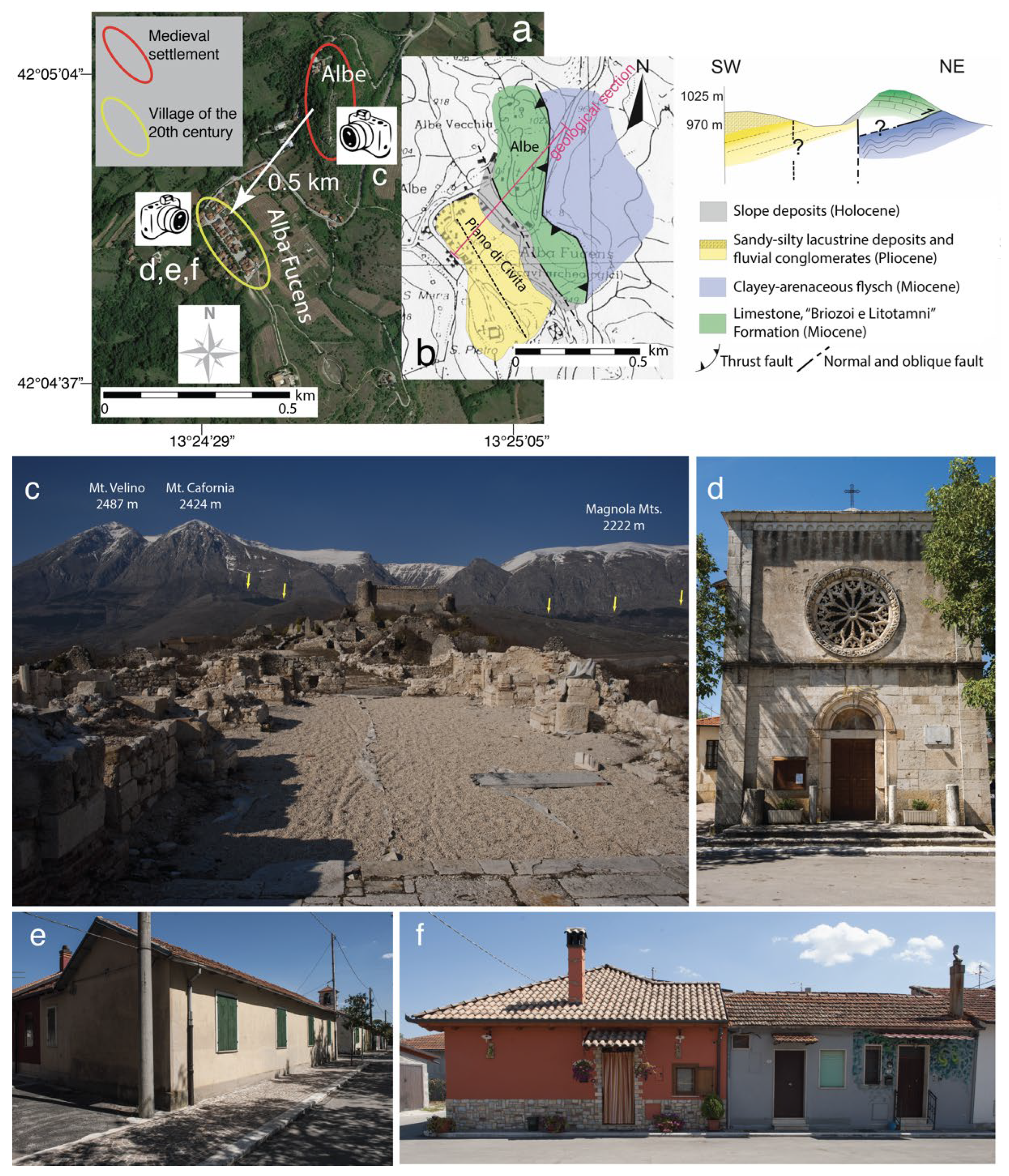
3.3. Albe
3.3.1. Geomorphological and Geographical Frameworks
3.3.2. Abandonment and Resettlement of Albe
3.3.3. Albe Today
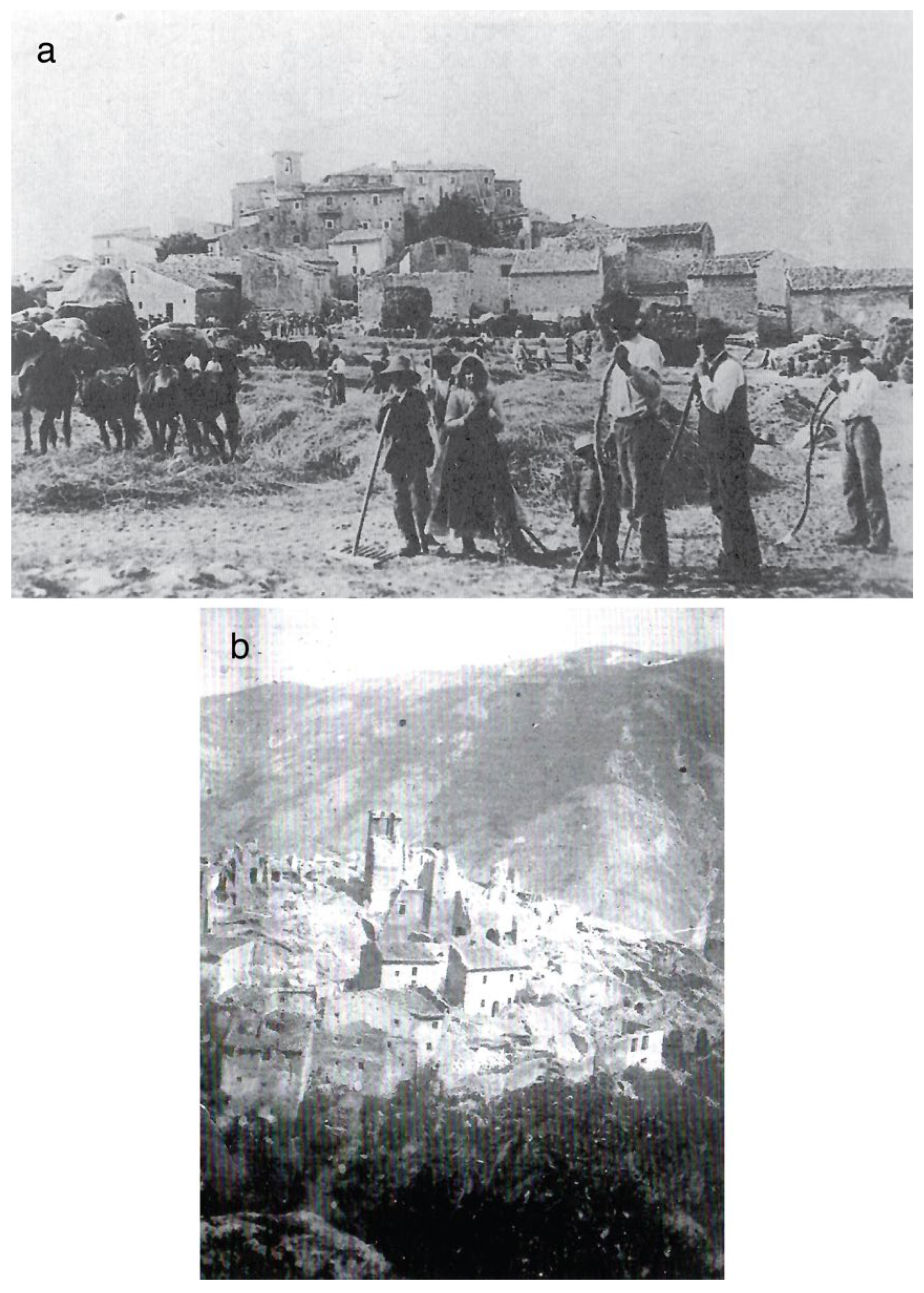
3.4. Salle
3.4.1. Geomorphological and Geographical Frameworks
3.4.2. Abandonment and Resettlement of Salle
3.4.3. Salle Today
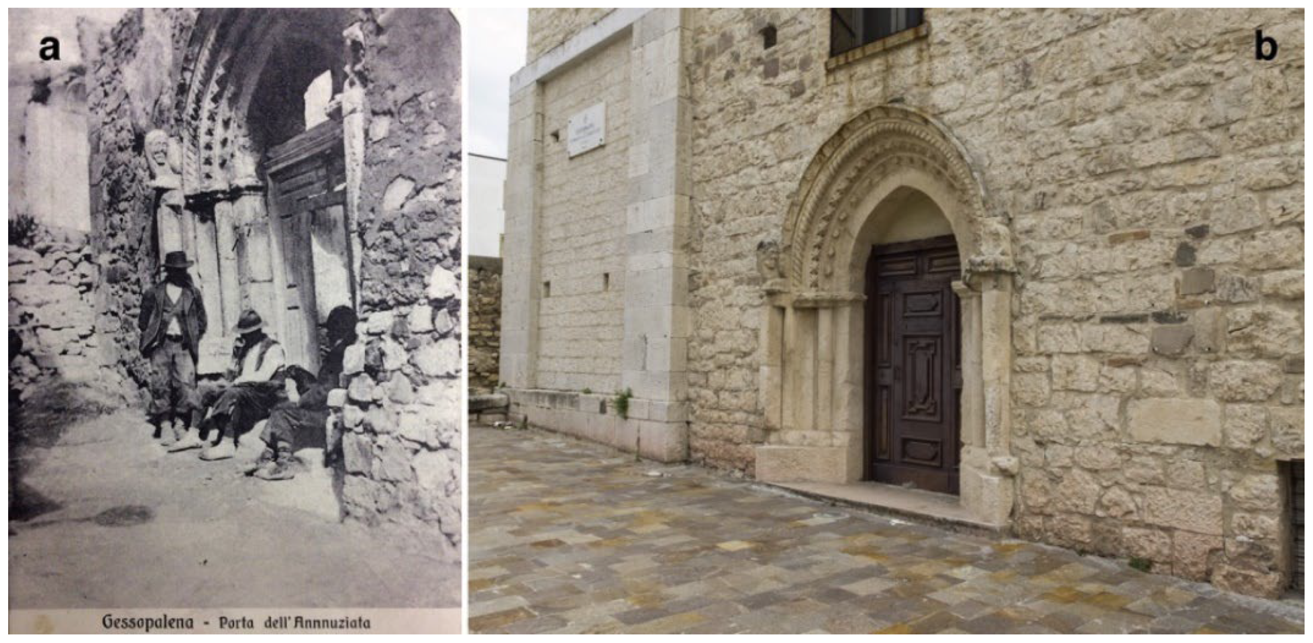
3.5. Gessopalena
3.5.1. Geomorphological and Geographical Frameworks
3.5.2. Abandonment and Resettlement of Gessopalena
3.5.3. Gessopalena Today
4. Discussion
4.1. The Role of Geological Knowledge in the Abandonment and Resettlement of Villages
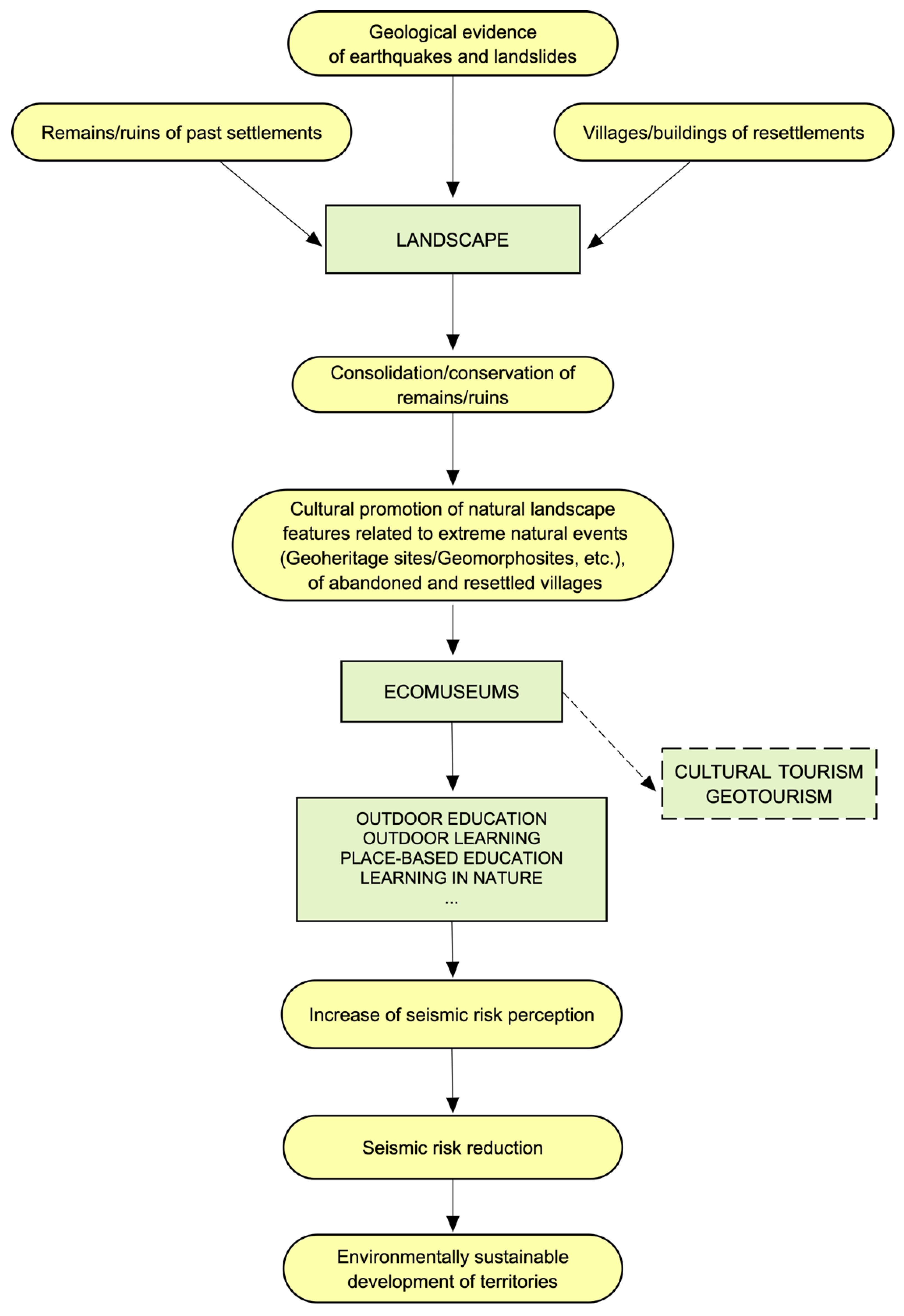
4.2. Landscape
4.3. Ecomuseums
4.4. Outdoor Education
4.5. Reduction of Seismic Risk
5. Conclusions
Funding
Data Availability Statement
Acknowledgments
Conflicts of Interest
Appendix A
Appendix A.1. Frattura
Appendix A.2. Sperone
Appendix A.3. Albe
Appendix A.4. Salle
Appendix A.5. Gessopalena
References
- Brown, L.R. Ghost Towns of the Colorado Rockies; Coxton Press: Caldwell, ID, USA, 1968; 402p. [Google Scholar]
- McNab, C. Ghost Towns; Amber Books: London, UK, 2016; 224p. [Google Scholar]
- East, M. Community-led approaches and interventions for the regeneration of abandoned towns in southern Italy. Ecocycles 2016, 2, 18–25. [Google Scholar] [CrossRef] [Green Version]
- East, M. Integrated approaches and interventions for the regeneration of abandoned towns in southern Italy. In From Conflict to Inclusion in Housing: Interaction of Communities, Residents and Activists; Cairns, G., Artopoulos, G., Day, K., Eds.; UCL Press: London, UK, 2017; pp. 87–102. [Google Scholar]
- Wickham, C. Castelli e incastellamento nell’Italia centrale: La problematica storica. In Civiltà Medioevale Negli Abruzzi; Boesch Gajano, S., Berardi, M.R., Eds.; Edizioni Libreria Colacchi: L’Aquila, Italy, 1990; Volume 1, pp. 110–123. [Google Scholar]
- Clementi, A. L’incastellamento negli Abruzzi: Problematica ed Esempi; Andromeda Editrice: Colledara, Italy, 1996; 79p. [Google Scholar]
- Redi, F. L’incastellamento nel territorio aquilano: Primi dati per una ricerca archeologica. Archeol. Mediev. 1997, 24, 427–438. [Google Scholar]
- Somma, M.C. Siti Fortificati e Territorio: Castra, Castella e Turres Nella Regione Marsicana Tra X e XII Secolo, 1st ed.; Fratelli Palombi Editori: Roma, Italy, 2000; 258p. [Google Scholar]
- Somma, M.C. Strutture fortificate ed incastellamento in area marsicana tra X e XII secolo. In Il Fucino e le Aree Limitrofe Nell’antichità; Archeoclub della Marsica: Avezzano, Italy, 2001; pp. 440–449. [Google Scholar]
- Marcotulli, C. Chiese, castelli e strategie ‘baronali’. Le trasformazioni del paesaggio medievale abruzzese tra feudalità signorile e città fondata alla luce della ricerca archeologica: Un caso di studio. Ricerche Storiche 2011, 41, 181–208. [Google Scholar]
- Lear, E. Illustrated Excursions in Italy, 1st ed.; Thomas McLean: London, UK, 1846; 144p. [Google Scholar]
- Macdonell, A. In the Abruzzi, 1st ed.; William Clowes and Sons Ltd.: London, UK, 1908; 309p. [Google Scholar]
- Canziani, E. Through the Apennines and the Lands of the Abruzzi: Landscape and Peasant Life; W. Heffer and Sons Ltd.: Cambridge, UK; Simpkin Marshall Ltd.: London, UK, 1928; Volume XIV, 339p. [Google Scholar]
- Serafini, L. Castelli e borghi fortificati nell’Appennino centrale d’Italia. Storia e conservazione. In Defensive Architecture of the Mediterranean, Proceedings of the International Conference on Fortifications of the Mediterranean Coast, FORTMED 2020, Granada, Spain, 26–28 March 2020; Navarro Palazón, J., García-Pulido, L.J., Eds.; Editorial Universitat Politècnica de València: Valencia, Spain, 2020; Volume 12, pp. 1393–1400. [Google Scholar] [CrossRef]
- Rovida, A.; Locati, M.; Camassi, R.; Lolli, B.; Gasperini, P.; Antonucci, A. Catalogo Parametrico dei Terremoti Italiani (CPTI15), Versione 4.0; Istituto Nazionale di Geofisica e Vulcanologia (INGV): Roma, Italy, 2022; Available online: http://10.13127/CPTI/CPTI15.4 (accessed on 14 July 2022).
- Lollino, G.; Manconi, A.; Guzzetti, F.; Culshaw, M.; Bobrowsky, P.; Luino, F. (Eds.) Engineering Geology for Society and Territory, Vol. 5: Urban. Geology, Sustainable Planning and Landscape Exploitation; Springer Nature: Berlin/Heidelberg, Germany, 2015; 1400p. [Google Scholar]
- Amanti, M.; Bencivenga, M.; Bramerini, F.; Cara, P.; Caserta, A.; Castenetto, S.; Colozza, R.; Coppari, S.; Corazza, A.; Crescenzi, R.; et al. La geologia di Roma. Il centro storico. Mem. Descr. Carta Geol. d’Italia 1995, 50, 9–550. [Google Scholar]
- Morra, V.; Calcaterra, D.; Cappelletti, P.; Colella, A.; Fedele, L.; de’ Gennaro, R.; Langella, A.; Mercurio, M.; de’ Gennaro, M. Urban geology: Relationships between geological setting and architectural heritage of the Neapolitan area. J. Virtual Explor. 2010, 36, 60. [Google Scholar] [CrossRef]
- Gizzi, F.T.; Bentivenga, M.; Lasaponara, R.; Danese, M.; Potenza, M.R.; Sileo, M.; Masini, N. Natural hazards, human factors, and “ghost towns”: A multi-level approach. Geoheritage 2019, 11, 1533–1565. [Google Scholar] [CrossRef]
- Migoń, P.; Pijet-Migoń, E. Natural disasters, geotourism and geo-education. Geoheritage 2019, 11, 629–640. [Google Scholar] [CrossRef] [Green Version]
- Malinverno, A.; Ryan, W.B.F. Extension in the Tyrrhenian sea and shortening in the Apennines as result of arc migration driven by sinking of the lithosphere. Tectonics 1986, 5, 227–245. [Google Scholar] [CrossRef]
- Royden, L.; Patacca, E.; Scandone, P. Segmentation and configuration of subducted lithosphere in Italy: An important control on thrust-belt and foredeep-basin evolution. Geology 1987, 15, 714–717. [Google Scholar] [CrossRef]
- Patacca, E.; Sartori, R.; Scandone, P. Tyrrhenian basin and Apenninic Arcs: Kinematic Relations since Late Tortonian Times. Mem. Soc. Geol. It. 1990, 45, 425–451. [Google Scholar]
- Cipollari, P.; Cosentino, D. Miocene unconformities in the central Apennines: Geodynamic significance and sedimentary basin evolution. Tectonophysics 1995, 252, 375–389. [Google Scholar] [CrossRef]
- Cosentino, D.; Cipollari, P.; Marsili, P.; Scrocca, D. Geology of the central Apennines: A regional review. In The Geology of Italy; Beltrando, M., Peccerillo, A., Mattei, M., Conticelli, S., Doglioni, C., Eds. J. Virtual Explor. 2010, 36, 11. [Google Scholar] [CrossRef]
- Locati, M.; Camassi, R.; Rovida, A.; Ercolani, E.; Bernardini, F.; Castelli, V.; Caracciolo, C.H.; Tertulliani, A.; Rossi, A.; Azzaro, R.; et al. Database Macrosismico Italiano (DBMI15), Versione 4.0.; Istituto Nazionale di Geofisica e Vulcanologia (INGV): Roma, Italy, 2022. [Google Scholar] [CrossRef]
- CNR-PFG. Neotectonic map of Italy. In Quaderni de La Ricerca Scientifica; Consiglio Nazionale delle Ricerche: Roma, Italy, 1987; Volume 114. [Google Scholar]
- Galadini, F.; Messina, P.; Giaccio, B.; Sposato, A. Early uplift history of the Abruzzi Apennines (central Italy): Available geomorphological constraints. Quat. Int. 2003, 101, 125–135. [Google Scholar] [CrossRef]
- D’Agostino, N.; Jackson, J.A.; Dramis, F.; Funiciello, R. Interactions between mantle upwelling, drainage evolution and active normal faulting: An example from the central Apennines (Italy). Geophys. J. Int. 2001, 147, 475–497. [Google Scholar] [CrossRef]
- Bosi, C.; Galadini, F.; Giaccio, B.; Messina, P.; Sposato, A. Plio-Quaternary continental deposits in the Latium-Abruzzi Apennines: The correlation of geological events across different intermontane basins. Quaternario 2003, 16, 55–76. [Google Scholar]
- Galadini, F.; Galli, P. Active tectonics in the Central Apennines (Italy)—Input data for seismic hazard Assessment. Nat. Haz. 2000, 22, 225–270. [Google Scholar] [CrossRef]
- Boncio, P.; Lavecchia, G.; Pace, B. Defining a model of 3D seismogenic sources for Seismic Hazard Assessment applications: The case of central Apennines (Italy). J. Seism. 2004, 8, 407–425. [Google Scholar] [CrossRef]
- Valentini, A.; Visini, F.; Pace, B. Integrating faults and past earthquakes into a probabilistic seismic hazard model for peninsular Italy. Nat. Hazards Earth Syst. Sci. 2017, 17, 2017–2039. [Google Scholar] [CrossRef] [Green Version]
- Galadini, F.; Falcucci, E.; Gori, S.; Zimmaro, P.; Cheloni, D.; Stewart, J.P. Active Faulting in Source Region of 2016–2017 Central Italy Event Sequence. Earthq. Spectra 2018, 34, 1557–1583. [Google Scholar] [CrossRef]
- Lavecchia, G.; de Nardis, R.; Di Naccio, D.; Ferrarini, F.; Cirillo, D.; Brozzetti, F. Active compression in Eastern Abruzzo (central Italy): Evidences from geological morphotectonic and macroseismic data analyses. Rend. Online Soc. Geol. It. 2015, 36 (Suppl. S1), 45. [Google Scholar]
- Racano, S.; Fubelli, G.; Centamore, E.; Bonasera, M.; Dramis, F. Geomorphological detection of surface effects induced by active blind thrusts in the southern Abruzzi peri-Adriatic belt (Central Italy). Geogr. Fis. Din. Quat. 2020, 43, 3–13. [Google Scholar] [CrossRef]
- Serafini, L. Danni di Guerra e Danni di Pace: Ricostruzione e Città Storiche in Abruzzo nel Secondo Dopoguerra; Casa Editrice Tinari: Villamagna, Italy, 2008; 229p. [Google Scholar]
- Almagià, R. Studi geografici sulle frane in Italia. Volume II. L’Appennino centrale e meridionale. Conclusioni generali. Memorie della Società Geografica Italiana 1910, 14, 1–431. [Google Scholar]
- D’Andrea, U. L’antico abitato di Salle dai Tempi Aragonesi al Terremoto Della MARSICA (1443–1915); Topografia dell’Abbazia di Casamari: Frosinone, Italy, 1983; 152p. [Google Scholar]
- Serafini, L. Abbandono e necrosi dei centri minori dopo il sisma del 1915. Argomenti per il recupero. In Marsica 1915—L’Aquila 2009: Un Secolo di Ricostruzioni; Galadini, F., Varagnoli, C., Eds.; Gangemi Editore: Roma, Italy, 2016; pp. 223–234. [Google Scholar]
- De Vecchis, G. La Montagna Italiana: Verso Nuove Dinamiche Territoriali: I Valori del Passato e le Prospettive di Recupero e Sviluppo; Edizioni Kappa: Roma, Italy, 1992; 274p. [Google Scholar]
- Falcone, C. Il Niente del Dopo; Gruppo Tipografico Editoriale: L’Aquila, Italy, 2002; 115p. [Google Scholar]
- Di Falco, G.; Manzi, A.; Manzi, G. I Gessi di Gessopalena e Della Valle Dell’aventino: Un Museo del Territorio; Casa Editrice Ianieri: Silvi Marina, Italy, 2003; 64p. [Google Scholar]
- Pitoni, G.; Salvi, A. Albe Medioevale; LCL: Avezzano, Italy, 2002; 104p. [Google Scholar]
- Ceccaroni, E. Archeologia e terremoto nella Marsica: Un confronto sempre attuale. In Marsica 1915—L’Aquila 2009. Un Secolo di Ricostruzioni; Galadini, F., Varagnoli, C., Eds.; Gangemi Editore: Roma, Italy, 2016; pp. 271–300. [Google Scholar]
- Comitato Speciale del Consiglio dei Lavori Pubblici. Relazione del Comitato Speciale del Consiglio dei Lavori Pubblici Incaricato di Studiare e Proporre Norme Edilizie Obbligatorie per i Comuni Colpiti dal Terremoto del 13 Gennaio 1915; Tipografia dell’Unione Editrice: Roma, Italy, 1915; 92p. [Google Scholar]
- Nicoletti, P.G.; Parise, M.; Miccadei, E. The Scanno rock avalanche (Abruzzi, south-central Italy). Boll. Soc. Geol. It. 1993, 112, 523–535. [Google Scholar]
- Bianchi Fasani, G.; Cercato, M.; Esposito, C.; Petitta, M. Il Lago di sbarramento di Scanno: Considerazioni riguardo le condizioni di stabilità. G. Di Geol. Appl. 2005, 2, 45–50. [Google Scholar] [CrossRef]
- Caranfa, A. Contributo per una datazione della frana di Monte Genzana e del lago di Scanno: Rivista abruzzese. Rass. Trimest. Cult. 2010, 63, 141–146/250–254. [Google Scholar]
- Esposito, C.; Bianchi-Fasani, G.; Martino, S.; Scarascia Mugnozza, G. Quaternary gravitational morpho-genesis of Central Apennines (Italy): Insights from the Mt. Genzana case history. Tectonophysics 2013, 605, 96–103. [Google Scholar] [CrossRef]
- Della Seta, M.; Esposito, C.; Marmoni, G.M.; Martino, S.; Scarascia Mugnozza, G.; Troiani, F. Morpho-structural evolution of the valley-slope systems and related implications on slope-scale gravitational processes: New results from the Mt. Genzana case history (Central Apennines, Italy). Geomorphology 2017, 289, 60–77. [Google Scholar] [CrossRef]
- Servizio Geologico d’Italia. Geological Map of Italy, Scale 1:50.000, Sheet 378 Scanno; ISPRA: Roma, Italy, 2010. Available online: http://www.isprambiente.gov.it/Media/carg/378_SCANNO/Foglio.html (accessed on 14 July 2022).
- Serva, L.; Blumetti, A.M.; Michetti, A.M. Gli effetti sul terreno del terremoto del Fucino (13 Gennaio 1915); tentativo di interpretazione della evoluzione tettonica recente di alcune strutture. Mem. Soc. Geol. It. 1986, 35, 893–907. [Google Scholar]
- Galadini, F.; Messina, P. Plio-Quaternary tectonics of the Fucino basin and surroundings areas (central Italy). G. Geol. 1994, 56, 73–99. [Google Scholar]
- Galadini, F.; Galli, P.; Giraudi, C. Gli effetti geologici del terremoto del 1915. In 13 gennaio 1915, il Terremoto Nella Marsica, 1st ed.; Castenetto, S., Galadini, F., Eds.; Istituto Poligrafico e Zecca dello Stato: Roma, Italy, 1999; pp. 283–299. [Google Scholar]
- Piacentini, T.; Miccadei, E.; Berardini, G.; Aratari, L.; De Ioris, A.; Calista, M.; Carabella, C.; d’Arielli, R.; Mancinelli, V.; Paglia, G.; et al. Geological tourist mapping of the Mount Serrone fault Geosite (Gioia dei Marsi, Central Apennines, Italy). J. Maps 2019, 15, 298–309. [Google Scholar] [CrossRef]
- Technical Commission on Seismic Microzonation. Land Use Guidelines for Areas with Active and Capable Faults (ACF); Conference of the Italian Regions and Autonomous Provinces—Civil Protection Department: Rome, Italy, 2015; Volume 55, VIIp, Available online: https://www.centromicrozonazionesismica.it/it/download/summary/20-seismic-microzonation-land-use-guidelines-for-areas-with-active-and-capable-faults-acf/66-seismic-microzonation-land-use-guidelines-for-areas-with-active-and-capable-faults-acf (accessed on 14 July 2022).
- Moro, M.; Saroli, M.; Gori, S.; Falcucci, E.; Galadini, F.; Messina, P. The interaction between active normal faulting and large scale gravitational mass movements revealed by paleoseismological techniques: A case study from central Italy. Geomorphology 2012, 151, 164–174. [Google Scholar] [CrossRef]
- Galadini, F.; Ceccaroni, E.; Dixit Dominus, G.; Falcucci, E.; Gori, S.; Maceroni, D.; Bonasera, M.; Di Giulio, G.; Moro, M.; Saroli, M.; et al. Combining earth sciences with archaeology to investigate natural risks related to the cultural heritage of the Marsica region (central Apennines, Italy). Mediterr. Geosci. Rev. 2022, 4, 32. [Google Scholar] [CrossRef]
- Galadini, F.; Ceccaroni, E.; Falcucci, E.; Gori, S.; Pagliaroli, A. Ambiente naturale, interventi antropici e modifiche del paesaggio ad Alba Fucens (IV sec. a.C.-XXI secolo d.C.). In Il Fucino e le Aree Limitrofe Nell’antichità: Archeologia e Rinascita Culturale Dopo il Sisma del 1915; Archeoclub della Marsica: Avezzano, Italy, 2016; pp. 399–411. [Google Scholar]
- Mancini, R.; Mezzoprete, M.P.; Palma, G. Il terremoto e le opere d’arte mobili. In 13 Gennaio 1915, il Terremoto Nella Marsica, 1st ed.; Castenetto, S., Galadini, F., Eds.; Istituto Poligrafico e Zecca dello Stato: Roma, Italy, 1999; pp. 405–450. [Google Scholar]
- Clément, G. Manifeste du Tiers Paysage [Manifesto del Terzo Paesaggio]; Quodlibet: Macerata, Italy, 2005; 87p. [Google Scholar]
- Servizio Geologico d’Italia. Geological Map of Italy, Scale 1:50.000, Sheet 369 Sulmona; ISPRA: Roma, Italy, 2005. Available online: https://www.isprambiente.gov.it/Media/carg/369_SULMONA/Foglio.html (accessed on 14 July 2022).
- Battaglia, K. Da villaggio anonimo a centro incastellato: Il destino di un feudo. In Il Castello di Salle Nelle Fonti Documentarie; Calvano, P., di Genova di Salle, M., Eds.; Salle Castle & Museum Trust: Salle, Italy; Salle Castle & Museum Trust: Coral Gables, FL, USA, 2009; Volume 2, pp. 70–83. [Google Scholar]
- Autorità di Bacino Distrettuale dell’Appennino Centrale. Piano Stralcio di Bacino per L’assetto Idrogeologico, Carta Della Pericolosità da Frana, Sheet 369E. Available online: https://www.autoritadistrettoac.it/sites/default/files/pianificazione/pianif_bacino/cart_online/abruzzo_sangro/versante/carta_peric_frana/P__369E.pdf (accessed on 14 July 2022).
- Autorità di Bacino Distrettuale dell’Appennino Centrale. Piano Stralcio di Bacino per L’assetto Idrogeologico, Carta del Rischio da Frana, Sheet 369E. Available online: https://www.autoritadistrettoac.it/sites/default/files/pianificazione/pianif_bacino/cart_online/abruzzo_sangro/versante/carta_rischio_frana/R_369E.pdf (accessed on 14 July 2022).
- Buccolini, M.; Sciarra, N. Conoscenze geologico-tecniche e distribuzione dei fenomeni franosi nella provincia di Pescara. Studi Geol. Camerti 1989, 11, 23–35. [Google Scholar]
- Racano, S.; Amoroso, S.; Del Nobile, M.; Galadini, F. A peculiar history of destruction at an old town center in Central Italy: Castel Frentano through the effects of a landslide followed by an earthquake in 1881 AD: The 1881 Castelfrentano damages due to landslides and earthquake. Alp. Mediterr. Quat. 2022, 35, 15. Available online: http://amq.aiqua.it/index.php/amq/article/view/377 (accessed on 30 July 2022). [CrossRef]
- Giannantonio, R. La costruzione del regime. Urbanistica, Architettura e Politica nell’Abruzzo del Fascismo; Casa Editrice Rocco Carabba: Lanciano, Italy, 2006; 859p. [Google Scholar]
- Servizio Geologico d’Italia. Geological Map of Italy, Scale 1:100.000, Sheet 147 Lanciano; ISPRA: Roma, Italy, 1970; Available online: http://sgi.isprambiente.it/geologia100k/mostra_foglio.aspx?numero_foglio=147 (accessed on 14 July 2022).
- Bigi, S.; Cantalamessa, G.; Centamore, E.; Didaskalou, P.; Dramis, F.; Farabollini, P.; Gentili, B.; Invernizzi, C.; Micarelli, A.; Nisio, S.; et al. La fascia periadritica marchigiano-abruzzese dal Pliocene medio ai tempi attuali: Evoluzione tettonico-sedimentaria e geomorfologica. Studi Geol. Camerti 1995, 1995/1, 37–49. [Google Scholar]
- Autorità di Bacino Distrettuale dell’Appennino Centrale. Piano Stralcio di Bacino per L’assetto Idrogeologico, Carta Della Pericolosità da Frana, Sheet 370E. Available online: https://www.autoritadistrettoac.it/sites/default/files/pianificazione/pianif_bacino/cart_online/abruzzo_sangro/versante/carta_peric_frana/P__370E.pdf (accessed on 14 July 2022).
- Giustiniani, L. Gesso prope Palena. In Dizionario Geografico-Ragionato del Regno di Napoli, Tomo V; Vincenzo Manfredi Stampatore: Napoli, Italy, 1802; 434p. [Google Scholar]
- Finamore, G. Delle Condizioni Economico-Agricole di Gessopalena; Stamperia dell’Unione Editrice: Torino, Italy, 1872; 79p. [Google Scholar]
- Varagnoli, C.; Pezzi, G.A. La cultura del restauro. In L’abruzzo nel Novecento; Russo, U., Tiboni, E., Eds.; Ediars: Pescara, Italy, 2004; pp. 509–532. [Google Scholar]
- Council of Europe. Council of Europe Landscape Convention; European Treaty Series—No. 176; Council of Europe: Firenze, Italy, 2000; 8p, Available online: https://rm.coe.int/16807b6bc7 (accessed on 14 July 2022).
- Ingold, T. The Perception of the Environment. Essays on Livelihood, Dwelling and Skill; Routledge: Abingdon, UK; Routledge: New York, NY, USA, 2000; 602p. [Google Scholar]
- Sobel, D. Place-based education: Connecting classroom and community. Nat. Listening 2004, 4, 1–7. [Google Scholar]
- Castiglioni, B. Education on Landscape for Children. In Proceedings of the 5th Council of Europe Conference on the European Landscape Convention, Report CEP-CDPATEP (2009) 12E. Council of Europe, Strasbourg, France, 1 February 2009; Available online: https://rm.coe.int/16806b081b (accessed on 14 July 2022).
- Morag, O.; Tal, T. Assessing Learning in the Outdoors with the Field Trip in Natural Environments (FiNE) Framework. Int. J. Sci. Educ. 2012, 34, 745–777. [Google Scholar] [CrossRef]
- Wattchow, B. Landscape and a sense of place: A creative tension. In The Routledge Companion to Landscape Studies; Howard, P., Thompson, I., Waterton, E., Eds.; Routledge: Abingdon, UK; Routledge: New York, NY, USA, 2013; pp. 87–96. [Google Scholar]
- Perla, L.; Brusa, A.; Vinci, V. Insegnare il paesaggio storico. Tratteggio didattico co-epistemologico. G. Ital. Della Ric. Educ.—Ital. J. Educ. Res. 2018, XI, 125–150. [Google Scholar]
- Bellentani, F. Landscape as text. In Concepts for Semiotics; Rodriguez Higuera, C.J., Bennett, T.J., Eds.; University of Tartu Press: Tartu, Estonia, 2016; pp. 76–87. [Google Scholar]
- Lewis, P.K. Axioms of the landscape: Some guides to the american scene. In The Interpretation of Ordinary Landscapes; Meinig, D.W., Ed.; Oxford University Press: New York, NY, USA; Oxford University Press: Oxford, UK, 1979; pp. 11–32. [Google Scholar]
- Manganelli, G. La Penombra Mentale. Interviste e Conversazioni 1965–1990; Editori Riuniti: Roma, Italy, 2001; 237p. [Google Scholar]
- Lindström, K.; Kull, K.; Palang, H. Semiotic study of landscapes: An overview from semiology to ecosemiotics. Sign Syst. Stud. 2011, 39, 12–36. [Google Scholar] [CrossRef]
- Szczepanski, A. Outdoor Education. Authentic Learning in the Context of Landscape (Place Based) Literary Education and Sensory Experience. Available online: http://www.norskfriluftsliv.no/wp-content/uploads/2016/03/extra_outdoor_education_anders_szczepanski-1.pdf (accessed on 14 July 2022).
- Corsane, G.E.; Davis, P.S.; Hawke, S.K.; Stefano, M.L. Ecomuseology: A Holistic and Integrated Model for Safeguarding ‘Spirit of Place’ in the North East of England. In Finding the Spirit of Place—Between the Tangible and the Intangible. In Proceedings of the 16th ICOMOS General Assembly and International Symposium, Quebec, QC, Canada, 29 September–4 October 2008; Available online: http://openarchive.icomos.org/id/eprint/11/ (accessed on 14 July 2022).
- Riva, R. (Ed.) Ecomuseums and Cultural Landscapes. State of the Art and Future Prospects; Maggioli Editore: Sant’Arcangelo di Romagna, Italy, 2017; 406p. [Google Scholar]
- Dal Santo, R.; Baldi, N.; Del Duca, A.; Rossi, A. The Strategic Manifesto of Italian Ecomuseums. Mus. Int. 2017, 69, 86–95. [Google Scholar] [CrossRef]
- Pedram, B.; Emami, M.A.; Khakban, M. Role of the open-air museum in the conservation of the rural architectural heritage. Conserv. Sci. Cult. Herit. 2018, 18, 101–120. [Google Scholar] [CrossRef]
- La Longa, F.; Crescimbene, M.; Lanza, T. The Eco-Museum an Innovative Educational Methodology to Discover the Earth Sciences; Società Geologica Italiana, Congress “Geoscienze 2014”, “The Future of Italian Geosciences—The Italian Geosciences of the Future”. Available online: https://www.earth-prints.org/handle/2122/9244 (accessed on 14 July 2022).
- Poletti Ecclesia, E. The Ecomuseum of Montorfano Granite. Past, present, and future. In Ecomuseums and Cultural Landscapes. State of the Art and Future Prospects; Riva, R., Ed.; Maggioli Editore: Sant’Arcangelo di Romagna, Italy, 2017; pp. 181–187. [Google Scholar]
- Bonet, L. Cultural tourism. In A Handbook of Cultural Economics, 2nd ed.; Towse, R., Ed.; Edward Elgar: Cheltenham, UK; Edward Elgar: Northampton, MA, USA, 2011; pp. 166–171. [Google Scholar]
- Richards, G. Cultural Tourism: A review of recent research and trends. J. Hosp. Tour. Manag. 2018, 36, 12–21. [Google Scholar] [CrossRef]
- Pijet-Migoń, E.; Migoń, P. Geoheritage and cultural heritage—A review of recurrent and interlinked themes. Geosciences 2022, 12, 98. [Google Scholar] [CrossRef]
- Coratza, P.; De Waele, J. Geomorphosites and natural hazards: Teaching the importance of geomorphology in society. Geoheritage 2012, 4, 195–203. [Google Scholar] [CrossRef]
- Riva, R.; Chávez, E.S. Ecomuseums and UNESCO heritage sites: Shared management strategies. In Ecomuseums and Cultural Landscapes. State of the Art and Future Prospects; Riva, R., Ed.; Maggioli Editore: Sant’Arcangelo di Romagna, Italy, 2017; pp. 43–52. [Google Scholar]
- Tang, Y. Dark tourism to seismic memorial sites. In The Palgrave Handbook of Dark Tourism Studies; Stone, P.R., Hartman, R., Seaton, T., Sharpley, R., White, L., Eds.; Palgrave Macmillan: London, UK, 2018; pp. 423–441. [Google Scholar] [CrossRef]
- Margottini, C.; Di Buduo, G. The geological and landslides museum of Civita di Bagnoregio (Central Italy). Landslides 2017, 14, 435–445. [Google Scholar] [CrossRef]
- Gruenewald, D.A. The Best of Both Worlds: A Critical Pedagogy of Place. Educ. Res. 2003, 32, 3–12. [Google Scholar] [CrossRef] [Green Version]
- Brody, M. Learning in nature. Environ. Educ. Res. 2005, 11, 603–621. [Google Scholar] [CrossRef]
- Martin, P. Human to nature relationships through outdoor education. In Outdoor and Experiential Learning. Views from the Top; Dickson, T.J., Gray, T., Hayllar, B., Eds.; Otago University Print: Dunedin, New Zealand, 2005; pp. 28–52. [Google Scholar]
- Dillon, J.; Rickinson, M.; Teamey, K.; Morris, M.; Young Choi, M.; Sanders, D.; Benefield, P. The value of outdoor learning: Evidence from research in the UK and elsewhere. Sch. Sci. Rev. 2006, 87, 107–111. [Google Scholar]
- Beames, S. Place-Based Education: A Reconnaissance of the Literature Pathways. Ont. J. Outdoor Educ. 2015, 28, 27–30. [Google Scholar]
- Roberts, J.W. Re-Placing Outdoor Education: Diversity, Inclusion, and the Microadventures of the Everyday. J. Outdoor Recreat. Educ. Leadersh. 2018, 10, 20–32. [Google Scholar] [CrossRef]
- Mannion, G.; Fenwick, A.; Nugent, C.; I’Anson, J. Teaching in Nature; Scottish Natural Heritage Commissioned Report No. 476; 42p. Available online: https://www.nature.scot/sites/default/files/2017-07/Publication%202011%20-%20SNH%20Commissioned%20Report%20476%20-%20Teaching%20in%20nature.pdf (accessed on 14 July 2022).
- Mannion, G.; Fenwick, A.; Lynch, J. Place-responsive pedagogy: Learning from teachers’ experiences of excursions in nature. Environ. Educ. Res. 2012, 19, 792–809. [Google Scholar] [CrossRef]
- Lewicka, M. Ways to make people active: The role of place attachment, cultural capital, and neighborhood ties. J. Environ. Psychol. 2005, 25, 381–395. [Google Scholar] [CrossRef]
- Lewicka, M. Place attachment, place identity, and place memory: Restoring the forgotten city past. J. Environ. Psychol. 2008, 28, 209–231. [Google Scholar] [CrossRef]
- Lewicka, M. In search of roots: Memory as enabler of place attachment. In Place Attachment. Advances in Theory, Methods and Applications; Manzo, L.C., Devine-Wright, P., Eds.; Routledge: Abingdon, UK; Routledge: New York, NY, USA, 2014; pp. 49–60. [Google Scholar]
- Manzo, L.C.; Perkins, D.D. Finding Common Ground: The Importance of Place Attachment to Community Participation and Planning. J. Plan. Lit. 2006, 20, 335–350. [Google Scholar] [CrossRef] [Green Version]
- Nowell, B.L.; Berkowitz, S.L.; Deacon, Z.; Foster-Fishman, P. Revealing the Cues Within Community Places: Stories of Identity, History, and Possibility. Am. J. Commun. Psychol. 2006, 37, 29–46. [Google Scholar] [CrossRef]
- Höppner, C.; Frick, J.; Buchecker, M. What Drives People’s Willingness to Discuss Local Landscape Development? Landsc. Res. 2008, 33, 605–622. [Google Scholar] [CrossRef]
- Carrus, G.; Scopelliti, M.; Fornara, F.; Bonnes, M.; Bonaiuto, M. Place Attachment, Community Identification, and Pro-Environmental Engagement. In Place Attachment. Advances in Theory, Methods and Applications; Manzo, L.C., Devine-Wright, P., Eds.; Routledge: Abingdon, UK; Routledge: New York, NY, USA, 2014; pp. 154–164. [Google Scholar]
- Butler, A.; Berglund, U. Landscape Character Assessment as an Approach to Understanding Public Interests within the European Landscape Convention. Landsc. Res. 2014, 3, 219–236. [Google Scholar] [CrossRef] [Green Version]
- Marincioni, F.; Appiotti, F.; Ferretti, M.; Antinori, C.; Melonaro, P.; Pusceddu, A.; Oreficini-Rosi, R. Perception and communication of seismic risk: The 6 April 2009 L’Aquila earthquake case study. Earthq. Spectra 2012, 28, 159–183. [Google Scholar] [CrossRef]
- Crescimbene, M.; La Longa, F.; Camassi, R.; Pino, N.A. The seismic risk perception questionnaire. In Geoethics: The Role and Responsibility of Geoscientists; Peppoloni, S., Di Capua, G., Eds.; Special Publications; Geological Society: London, UK, 2015; Volume 419, pp. 69–77. [Google Scholar] [CrossRef]
- Stucchi, M.; Meletti, C.; Montaldo, V.; Akinci, A.; Faccioli, E.; Gasperini, P.; Malagnini, L.; Valensise, G. Pericolosità Sismica di Riferimento per il Territorio Nazionale MPS04; Istituto Nazionale di Geofisica e Vulcanologia (INGV): Rome, Italy, 2004. [Google Scholar] [CrossRef]


Publisher’s Note: MDPI stays neutral with regard to jurisdictional claims in published maps and institutional affiliations. |
© 2022 by the author. Licensee MDPI, Basel, Switzerland. This article is an open access article distributed under the terms and conditions of the Creative Commons Attribution (CC BY) license (https://creativecommons.org/licenses/by/4.0/).
Share and Cite
Galadini, F. Ruins and Remains as a Background: Natural Catastrophes, Abandonment of Medieval Villages, and the Perspective of Civilization during the 20th Century in the Central Apennines (Abruzzi Region, Central Italy). Sustainability 2022, 14, 9517. https://doi.org/10.3390/su14159517
Galadini F. Ruins and Remains as a Background: Natural Catastrophes, Abandonment of Medieval Villages, and the Perspective of Civilization during the 20th Century in the Central Apennines (Abruzzi Region, Central Italy). Sustainability. 2022; 14(15):9517. https://doi.org/10.3390/su14159517
Chicago/Turabian StyleGaladini, Fabrizio. 2022. "Ruins and Remains as a Background: Natural Catastrophes, Abandonment of Medieval Villages, and the Perspective of Civilization during the 20th Century in the Central Apennines (Abruzzi Region, Central Italy)" Sustainability 14, no. 15: 9517. https://doi.org/10.3390/su14159517
APA StyleGaladini, F. (2022). Ruins and Remains as a Background: Natural Catastrophes, Abandonment of Medieval Villages, and the Perspective of Civilization during the 20th Century in the Central Apennines (Abruzzi Region, Central Italy). Sustainability, 14(15), 9517. https://doi.org/10.3390/su14159517