Article

Implications of Land Use/Land Cover Changes and Climate Change on Black Volta Basin Future Water Resources in Ghana

by
Joachim Ayiiwe Abungba
1,2,*,
Kwaku Amaning Adjei
1,
Charles Gyamfi
1,
Samuel Nii Odai
1,3,
Santosh Murlidhar Pingale
4 and
Deepak Khare
2
1
Department of Civil Engineering, Regional Water and Environmental Sanitation Center Kumasi, Kwame Nkrumah University of Science and Technology, Kumasi GPS AK-448-4944, Ghana
2
Department of Water Resources Development and Management, Indian Institute of Technology, Roorkee 247667, India
3
Vice Chancellors Office, Accra Technical University, Barnes Road, Accra P.O. Box 561, Ghana
4
Hydrological Investigations Division, National Institute of Hydrology, Roorkee 247667, India
*
Author to whom correspondence should be addressed.
Sustainability 2022, 14(19), 12383; https://doi.org/10.3390/su141912383
Submission received: 8 August 2022 / Revised: 21 September 2022 / Accepted: 23 September 2022 / Published: 29 September 2022

Abstract

:
The Black Volta River basin faces several challenges, which impede the sustainability of its water resources and biodiversity. Climate change coupled with land use/land cover (LULC) change patterns account for most of the observed hydrological changes in the basin. The aim of this study was to assess the impact of changes in the climate and LULC on water resources in the basin, and its effect on the livelihoods of downstream users, particularly regarding water allocations. The water evaluation and planning (WEAP) model was applied to the assessment of runoff and streamflow and the percentage future water demand under climate change scenarios (RCP 2.6 and RCP 8.5), as well as the effects of current and future changes on water supply systems. LULC data from 1990 to 2019 were processed to detect the changes in LULC patterns in the basin. The results showed that from 1990 and 2019, the land use classes of settlements/bare ground, open savannah woodland, croplands, and waterbodies increased by 339.5%, 77.4%, 24.4%, and 607%, respectively. Close savannah woodlands, wetlands, and grasslands all decreased by 97%, 99.8%, and 21.2%, respectively. Overall, there was a significant difference in LULC changes. Hence, measures needed to be put in place to curb the changes, as the observed changes posed a serious challenge to the basin’s water resources. The results from the WEAP simulations also indicated that in the future, changes in discharge would be visible in September with ranges between 0.72 × 10⁶ m3 and 1.9 × 10⁶ m3 for RCP 2.6, and 0.65 × 10⁶ m3 and 2.5 × 10⁶ m3 for RCP 8.5, per month. Although the median values illustrate an increase in water availability from river discharge compared with the reference scenario, the uncertainties in future changes largely exceeded the predicted increases. Annual variability of the mean annual flows is projected to decrease over the period in the Black Volta Basin. Therefore, the outcomes of this study will be useful for different stakeholders within the basin in water resources planning and the formulation of appropriate policies for improving land use planning.

1. Introduction

Changes in land use/land cover (LULC) play a major role in the hydrology of a river basin. The available research shows a strong correlation between the changes in vegetation cover and rainfall, as well as other parameters of the hydrological cycle [1,2,3,4]. Additionally, the adverse effects of LULC change on the hydrological cycle are also attributable to anthropogenic activities [5] such as degradation of the watershed, which involve the destruction of natural vegetative cover, the expansion of croplands, overgrazing, and increased area for plantations [6]. Climate change, to some extent, has also influenced changes in LULC by triggering the recurrence of extreme weather events, resulting in destructive soil erosion, flooding, and landslides [7].
Urbanization coupled with the use of land for intensive agriculture and irrigation has the potential to cause severe impacts on wetlands and their ecosystem services by influencing the water quantity and quality [8]. The alterations of wetlands for other land use activities has the potential to change local streamflow cycles and influence the microclimatic regimes of regions and basins [9]. The conversion of wetlands to built-up areas increases impervious surfaces that enhance and increase surface runoff generation, and thus influence regional water cycling [10].
The complexities of unpredicted change in the climate, in addition to LULC change, have led to declining yields and increased unreliability for local farming systems, especially in the economies of most developing countries, which still depend on rain fed agriculture [11,12]. LULC change affects the infiltration capacity of the land, which changes the dynamics of the runoff [13]. Population growth usually translates into an increase in land use for farming and urbanization [11,13], which has a consequent effect on hydrological dynamics, such as runoff, stream flow, and water quality [2,14,15].
Studies show that climate and LULC change have had huge impacts on the hydrology of many basins [16]. Ref. [2] in their study of the impact of LULC change on water balance components of the White Volta Basin in West Africa, came to the conclusion that different LULC changes contributed various effects in the annual water yield and evapotranspiration in the basin. The study specifically revealed that savannah and grasslands were being converted to farmlands at a very fast rate. A similar study by [17] on the impacts of LULC changes on the hydrology of a lowland rainforest catchment in Ghana revealed a strong correlation between LULC change and the components of water balance, especially with regards to stream flow.
A UNDP study on the impacts of climate change in the Black and White Volta Basins in Ghana revealed clear signs of climate change in these areas. The northern savannah part of Ghana, according to the study, is most vulnerable to the impacts of climate change. The study went further to warn that the impacts of climate change in these areas will include extreme weather events such as torrential rains, excessive heat, and severe dry winds [18]. The economic impacts of climate change in the northern parts of Ghana are manifested in the recurrence of extreme flood events and low agricultural productivity. This has exacerbated the north–south poverty divide, thereby increasing the pressure to migrate to the southern part of Ghana [18]. The Black Volta River system is the major source of water for many activities in the basin and for other parts of the country. It plays a critical role in the economy of Ghana by serving as a lifeline for agricultural activities [19], for the production of electricity for both domestic use and export [20], livestock raising, fisheries, recreation, and tourism [21].
The rate of LULC change in the basin is noted to be alarming owing to population growth and to the development of socio-economic activities in the basin [11]. The major factors that contribute to LULC change within the savannah agro-ecological zone are indirect (related to socio-economic and policy drivers) and direct (related to selective logging for, e.g., fire wood, rosewood, or slash and burn activities for land clearing) [22]. According to an FAO report [13,23], Ghana lost 2% of its forest area per year between 1990 and 2000 (i.e., 1.35 million hectares in 10 years). Current and future government policies in Ghana, such as the ‘One village One Dam’ policy, which seeks to construct about 570 small reservoirs [24] for irrigation and livelihood enhancement of the three northern regions, may further influence LULC changes, streamflow alteration, and quality within these areas [25].
To improve future hydrological budget estimates within river basins for efficient water resources management, it is important to quantify the effects of LULC change at both basin and sub-basin levels [26]. A study on the impact of climate change and LULC change on the hydrology of a river basin will help to identify critical shifts in hydrologic processes and to assess the availability of water resources for an increasing population, agricultural expansion, and industrialization [27,28]. Such knowledge will also help in the formulation of appropriate policies for improving land use planning [27,29]. Hence, the aim of this study was to assess LULC and climate change scenarios in the Lower Black Volta Basin within Ghana, and its impact on the hydrological components of the basin. This was carried out with the Water Evaluation and Planning (WEAP) model and GIS-based tools. The study will therefore provide a deeper understanding of the effects of human activities and climate change on water resources in the basin, and its corresponding impacts on downstream users, especially water allocation, thereby serving as a guide to water resources managers and other stakeholders.

2. Materials and Methods
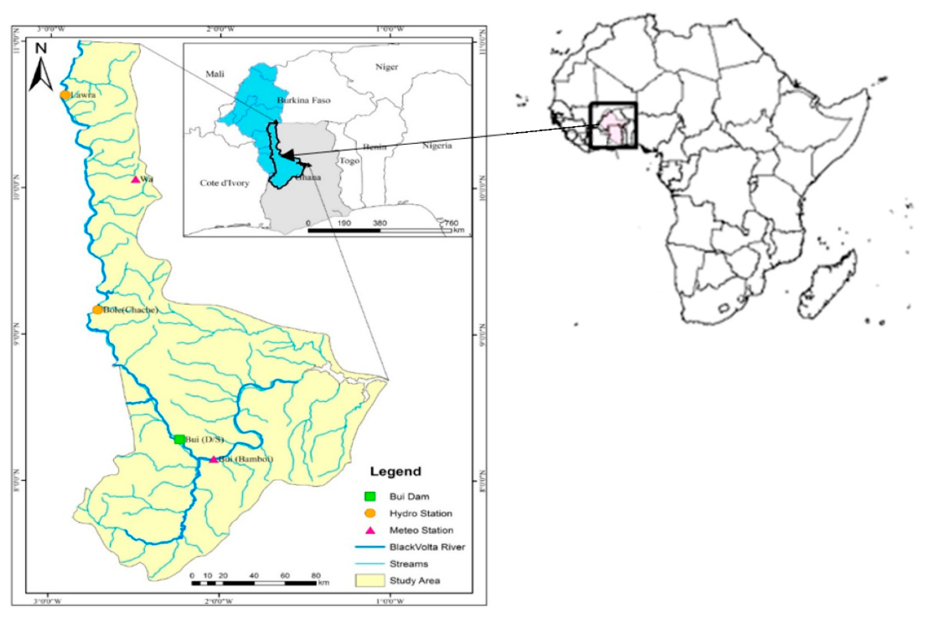
2.1. Study Area

The basin, which constitutes about 37% of the Volta River Basin system, lies between a latitude of 7.5° N and 14.3° N and a longitude of 5.5° W to 2.5° W (Figure 1). The river basin originates from southern Mali, flows through southern Burkina Faso and eastern Cote d’Ivoire to north-western Ghana, draining a total surface area of about 147,000 km2 [30], with the authors of [31] estimating a total surface area of 142,056 km2 for the basin. Agro-ecologically, the northern and southern portions of the basin lie within the northern savanna zone and the transitional zone, respectively [32].
The Ghana portion of the basin, according to Barry et al. (2005), covers an area of 33,302 km2, constituting 23.5% of the Basin and five (5) major sub-catchments, namely Lerinord, Nwokuy/Vonkoro, Bui, Dapola, Noumbiel, and Bamboi (Table 1). Table 1 indicates the major sub-basins in the Black Volta Basin and the dominant land use forms. Tain and Poni are the main tributaries that run out of Bougouriba, VounHou, Gbongbo, Sourou, Wenare, Bambassou, Bondami, Mouhoun (Black Volta), and Grand Bale.
The vegetation zones in the basin are covered from the north to south, with the Sahel being sparsely vegetated to savannah areas and the Guinea forest portion in the extreme South. The dominant soil type in the Black Volta Basin covers mainly Luvisols and Gleysols [33]. The rainfall pattern is highly erratic in the basin, and the annual rainfall ranges between 400 mm to 1500 mm. Most of the rainfall (about 70%) occurs between July and September in most parts. The mean monthly potential evapotranspiration for the basin exceeds the mean monthly rainfall for a more significant part of the year [11,34]. The annual rainfall for the entire basin is characterized by two distinct seasons, the rainy season and the dry season. The rainfall pattern for the northern part of the basin is mono-modal, which peaks between August and September, while the South consists of a bimodal pattern, which also peaks in May and September. The variation in the mean annual rainfall ranges from 500 mm for the extreme north in Mali, to about 1350 mm in the forested areas in southern Ghana [35].
In terms of political administration, the basin covers 26 districts (of the 261 district demarcations) in Ghana [36]. As of 2021, the population of the basin within Ghana stood at 3.9 million people [36]. Studies show that the Burkina Faso part of the basin is more developed for agri-cultural production compared with the Ghana portion [11,37].
A significant proportion of the basin’s population depends on the Black Volta River for domestic water supply, agriculture (irrigation and livestock watering), and fishing for their livelihoods [38]. It is also a source of hydropower generation and provides vital support to aquatic life [38,39] In addition to the above uses, mining activities have been rampant within the basin, especially in the northwestern and savannah regions, which also require a significant amount of water, with agriculture accounting for the dominant land use in the basin, with the land rotation system being the most practiced [40].
Major towns within the basin rely on surface water for domestic water use, which is largely supplied by the Ghana Water Company Limited and Community Water and Sanitation Agency, while almost all rural communities rely solely on groundwater as their source of drinking water as other studies in other countries according to [41] revealed similar use patterns. With some uses relying on the availability of streamflow which is impacted by climate variability and change [42]. According to [43], rainfall and extreme temperature are also highly variable and could affect how water resources are used in the basin.

2.2. Data Collection Method and Analysis

2.2.1. LULC Data

Given the importance of LULC in hydrological assessment, land cover data, among others, are an essential input in the WEAP model. Ground truth LULC maps developed (Figure 2) for the study area were harmonized with USGS West Africa LULC data (2016) for the modeling process.

2.2.2. Satellite Image Acquisition and Processing

Landsat ETM 7 with a resolution of 30 m × 30 m covering the study area from 1990 and 2019 was sourced from the [44].
The images were radiometrically and geometrically corrected geometrically corrected using ArcGIS 10.5 (Figure 2). The various bands were then stacked together and mosaicked to obtain one single image each for the two periods. The study area, i.e., area of interest, was subset from the processed mosaicked satellite images. Image band combinations were manipulated from the default natural color band combination in the image drape viewer so as to effectively identify the different land use types in the study area, which was later verified through ground truth in order to generate an appropriate training sample data set for supervised classification.
To improve the visual interpretability of the satellite data for a particular application, image enhancement was performed on all of the acquired scenes. Image enhancement made it possible to identify the apparent distinction between the features in each scene of the stacked image. In addition, point and local operation enhancement techniques were used to (1) further modify the brightness value of each pixel in an image data set for an independent digital number (DN) value, and to (2) modify the value of each pixel based on the neighboring brightness values. Classification was done for 1990 and 2019 images to identify the various land use types and changes that occurred over the years. The land use types were classified under settlements/bare ground, waterbodies, cropland, open savannah woodland, grasslands, closed savannah woodland, and wetlands. Accuracy assessment of the classified imagery was performed to assess the level of accuracy from the classification.

2.2.3. Unsupervised Classification

An initial unsupervised classification of the October 2019 image was generated with 14 classes and was used for the ground truth. The 14 classes took care of clouds and their shadows, which contributed three classes, while the adjoining images produced one class. The following classification schemes were used for the ground truth: closed savannah woodland (>150 trees/ha), open savannah woodland (<150 trees/ha), grassland with/without scattered trees (<10/ha), settlement/bare ground/pavements, waterbodies (river/dams), wetlands, and croplands.

2.2.4. Irrigated Crop Cover

A total of 153 observation points were recorded within two weeks of field work. The points were described according to the classification scheme and were also geo-referenced. All of the 153 points were grouped into nine classes according to their kind, and they were each saved as a CSV delimited file, which were later exported as shapefiles.

2.2.5. Supervised Classification

After ground truthing was completed, another supervised classification was performed on both the 1990 and 2019 images, with 20 classes each. The shapefiles were overlaid on the unsupervised classification maps one after the other to perform a re-classification exercise to reduce the classes from 20 to 7 based on the ground truth data. The LULC classification accuracy was determined using the Kappa Coefficient, as well as the user’s, producer’s, and overall accuracy. Change detection was executed in ArcGIS basically by comparing the 1990, 2000, 2010, and 2019 LULC images under their matrix operation.

2.3. WEAP Model Setup

The WEAP model was calibrated using the observed streamflow data for four-gauge stations located at upstream and downstream of the Black Volta River basin. The observed streamflow data was obtained from the Ghana Hydrological Services Department (HSD) from the 1965 to 2017 hydrological years. The streamflow was calibrated and validated against the observed streamflow on the average monthly basis for a period from 1993 to2003 and 2013 to 2014 hydrological years, respectively. The main sources of meteorological and hydrological data were the Ghana Meteorological Agency (GMet) and Hydrological Services Department, respectively. Both the meteorological and hydrological data were of the daily time series, as required by WEAP.

2.4. Climate Change Impact Assesment

Ten different global climate models (provided by the ISIMIP3b project for the Representative Concentration Pathway (RCP) 2.6 and 8.5), bias-adjusted and downscaled, were used to assess the impact of climate change on the precipitation, river discharge, and inflows into the Black Volta River.

3. Results

3.1. LULC of the Basin

The LULC classes within the study area were represented by seven (7) classes, as follows: closed savannah woodlands, croplands, open savanna woodlands, grasslands, settlement/bare ground, waterbodies, and wetlands. The results for the LULC classification for 1990 to 2019 are as presented in Figure 3 and Table 2 and Table 3.
The composite change detection results are presented in Figure 4a–c and Table 2. There was a decrease in grasslands, wetlands, and close savannah woodlands (Table 3). There was also an increase in open savannah woodlands, croplands, and settlements. Noticeable changes at ten-year intervals between 1990 and 2000, 2000 and 2010, and 2010 to 2019 are shown in Figure 5a–c. The above observation can be attributed to the conversion of areas experiencing a decreasing trend in settlements, and farmlands, as well as the extraction of wood and wood products such as charcoal from such areas.
The change detection showed an increase in waterbodies (rivers/dams/reservoirs) (Table 3). The decrease in grasslands, wetlands, and close savannah woodlands can be attributed to an increase in irrigated farming by both commercial and small-scale farmers, which led to the increase in agricultural activities and settlements. The increase in waterbodies might be due to the construction of the Bui Dam and a good number of smaller reservoirs that were constructed in the basin within that period, corresponding to an overall increase of 23,421.69 Ha and a percentage change of about 607% as shown in Table 2. In addition, close savannah woodlands decreased by about 97%, representing 63,977.31 hectares. Furthermore, the loss of wetlands by almost 99% in the basin is very interesting, and could be attributed to the search and use of such lands for farming, as well as the use of such lands for the construction of fuel stations, as depicted in Table 2. The actual clouds had the same reflectance signature as the rivers and dams/reservoirs, and therefore contributed to the actual area covered by this unit. The overall accuracy was 94%, 95%, 87%, and 76% for 1990/1991, 2000/2001, 2009/2010, and 2018/2019, respectively, with a Kappa Coefficient percentage of 88%, 92%, 84%, and 72%, respectively, for same period, as shown in Table 4. The overall decrease in vegetative cover resulted in a general increase in streamflow in the wet season, as shown in Figure 6. The removal of vegetative cover increased the runoff coefficient, thereby increasing the rate of streamflow. This also reduced the infiltration capacity and increased the runoff coefficient characteristics of the catchment, which led to an increase in runoff.

3.2. WEAP Scenarios Result

3.2.1. Streamflow and Runoff Alteration in Response to Climate Change Scenarios

Figure 6 shows the changes in future discharge for the Dapola Sub-Basin at the Lawra gauge, which is upstream of the basin, which results from the future changing conditions in the climate scenario simulations and the LULC changes. The changes are shown for RCP 2.6 and RCP 8.5, and the baseline land cover [16] and future land cover change. Overall, the differences that resulted from the land cover changes were moderate. The ranges in changes of discharge that result from the different climate projections were wide for the rainy season, where the differences between the RCP 8.5 simulations were almost twice as large compared with RCP 2.6.
The maximum ranges of the changes in discharge were visible for September with ranges between 0.72 × 10⁶ m3 and 1.9 × 10⁶ m3 for RCP 2.6 and 0.65 × 10⁶ m3 and 2.5 × 10⁶ m3 for RCP 8.5 per month as shown in Figure 6c. Although the median values illustrate an increase in water availability from river discharge compared with the reference scenario, the uncertainties in future changes largely exceeded the predicted increases. This is in response to typical rainfall development. Figure 7 shows the typical rainfall development under RCP 2.6.
Compared with the reference period (1984–2014), the average rainfall over the entire basin is projected to increase by about 6–8% for the time horizon of 2030 (years 2015 to 2045) and by 7–10% for the time horizon of 2050 (years 2035 to 2065). Furthermore, as shown in Figure 6, the general annual inflows into the area ranged between 0.3 billion cubic meters to 9.2 billion cubic meters for all RCP 2.6 scenarios, and 0.5 billion cubic meters to 105 billion cubic meters for all RCP 8.5 scenarios. RCP 2.6 with the scenario MPI-ESM 1-2 HR showed the highest flows among the RCP 2.6 scenarios, whereas RCP 8.5 with scenario CanCSM5 also showed the highest flows among the RCP 8.5 scenarios, even though it more than doubled the flows for RCP 2.6 MPI-ESM 1-2 HR. This means that with the current permitted abstractions in the basin, which exceeded 12 billion cubic meters, as shown in Table 5, the situation could get worse if more runoff is not stored to increase the water storage in the basin in order to respond to the water demand situation, especially with any of the scenarios under RCP 2.6.

3.2.2. Streamflow and Runoff Alteration for the Downstream Part for the Basin (Bamboi Sub-Basin) in Response to Climate Change Scenarios

The runoff for all of the scenarios in both RCP 2.6 and 8.5 showed some decline (Figure 8) in runoff into the sub-basin, which is downstream for the upper part of the basin within Ghana. Runoff for all future RCPs is not expected to exceed 105 billion cubic meters per annum. This expected available resource is expected only under RCP 8.5, with most of the remaining scenarios under both RCP 2.6 and 8.5 ranging between 0.5 billion cubic meters and 4.5 billion cubic meters. This could result in some dire consequences for infrastructure, such as the Bui hydroelectric Dam, which is located downstream in Ghana. The effect could even worsen if the proposed transboundary Noumbiel Dam between Ghana and Burkina Faso is eventually constructed upstream of the Bui Dam, considering that around 95% of the inflows are spread over 6 months in the wet season (July to December) and only 5% over the last 6 months in the dry season (January to June). This is consistent with recent studies on the Volta Basin Water Charter report [12,37]. The decrease for all scenarios is between 35% and 43%. This range falls within the decrease revealed by [35,37].

4. Discussion

The observed average monthly streamflow trends for both upstream and downstream are presented in Figure 9, and have been validated by [12,25,33]. The simulated streamflow was calibrated and validated against the observed streamflow on the average monthly basis for the period from 1993 to 2003 and 2013 to 2014 hydrological years, respectively.
With Sen’s slope, we analyzed the trend and its magnitude over the period from 1965 to 2008, with a linear trend line for both the upstream station (Lawra) and downstream station (Chache). The results of the streamflow indicate a decline in flows in response to the typical rainfall development of RCP 2.6. This will result in a reduction in water availability for downstream use and allocation. The indicated decrease for all scenarios was in the range revealed by [35,37].
The conversion of close savannah within the basin generally resulted in an increase in streamflow in the wet season. The conversion of these close savannah areas was in response to the need for socio-economic activities mainly related to agriculture in the basin, and this confirms studies by [11,17,27,28]. This could result in degradation of the banks of waterbodies and catchments through land erosion, stream flow alteration, and degradation of water quality, and this confirms earlier studies by [2,14,15]. The increase in waterbodies was due to the construction of the Bui Dam. Furthermore, a good number of smaller reservoirs were also constructed in the basin within the period, which could contribute to the increase in waterbodies, and this is evident in [33,37,38].
Overall, water resources availability for both RCP 2.6 and RCP 8.5 will not exceed 105 billion cubic meters per annum, with almost 95% of the flows spread out over 6 months in the wet season (July to December) and only 5% over the last 6 months in the dry season (January to June). This is consistent with recent studies on the Volta Basin Water Charter report [12,37]. The years 1981, 1983, 1984, and 2007 showed high streamflow, which were attributed to upstream releases from Burkina Faso, as well as severe cases of floods typically recorded within the basin in Ghana in the year 2007. Adequate policy requirements are therefore necessary, especially to guarantee minimum abstraction limits with our neighboring countries upstream so as to reduce future water security issues in Ghana, mainly to the Bui hydroelectric Dam.

5. Conclusions

Based on the study of the implications of land use/land cover changes and climate change on the Black Volta Basin regarding future water resources in Ghana, the following conclusions are summarized from the study:
  • It is evident from the results of the study that the LULC within the Black Volta Basin has witnessed a significant change within the period of 1990–2019. Settlement/bare ground, waterbodies, open savanna woodlands, and croplands all increased significantly by 339.5%, 607%, 77.4%, and 24.4%, respectively. Close savannah woodlands, grasslands, and wetlands, on the other hand, decreased by 97%, 21.2%, and 99.8%, respectively.
  • The decrease in closed savannah woodlands and the corresponding increase in open savannah woodlands is attributable to the surge in illegal wood harvesting, charcoal production, and the extension of farmlands into forest areas and buffer zones of water bodies. All of these are linked to the livelihoods of the local people, and are hence difficult to control. The increase in settlements/bare ground is attributable to the growth in the population of the basin, which comes along with the need for places of habitation and livelihood activities.
  • The results from the WEAP simulations indicate a link between streamflow/runoff and the LULC changes witnessed. The results from the WEAP simulations also indicated that in the future, the maximum ranges of the changes in discharge will be visible for September with ranges between 0.72 × 10⁶ m3 and 1.9 × 10⁶ m3 for RCP 2.6 and 0.65 × 10⁶ m3 and 2.5 × 10⁶ m3 for RCP 8.5. Climate change has also contributed to the observed changes.
  • The overall projected water resources availability for both RCP 2.6 and RCP 8.5 will not exceed 105 billion cubic meters per annum for the period of 1993 to 2064.
  • Based on the revelations brought forward by this study, there is an urgent need for sustainable integrated water resources management programs to be put in place to address the negative impacts of LULC changes on the hydrology of the Black Volta Basin. Proposed interventions should include components to ensure sustainable livelihood activities for the local people, as it has been realized that their dependence on the extraction of natural resources, among other activities, accounted for a significant part of the observed change. There is also a need for stakeholders’ investment in data gathering, especially for the vegetation and hydrological components of the basin, in order to better track future changes in time so that appropriate measures can be put in place to prevent the potential negative impacts.

Author Contributions

Conceptualization, J.A.A., K.A.A., C.G., S.N.O., S.M.P. and D.K.; methodology, K.A.A., C.G., S.N.O., S.M.P. and D.K.; software, J.A.A.; validation, J.A.A., K.A.A., C.G., S.N.O. and S.M.P.; formal analysis, J.A.A.; investigation, J.A.A.; resources, K.A.A., C.G. and S.N.O.; data curation, J.A.A.; writing—J.A.A., K.A.A., S.M.P. and C.G.; visualization, J.A.A., S.M.P. and D.K.; supervision, K.A.A., C.G. and S.N.O.; project administration, K.A.A., C.G. and S.N.O. All authors have read and agreed to the published version of the manuscript.

Funding

This research received no external funding.

Institutional Review Board Statement

Not applicable.

Informed Consent Statement

Not applicable.

Data Availability Statement

The data that support the findings of this study are available upon request from the corresponding author.

Acknowledgments

We acknowledge the scholarship received through the RWESCK Africa Center of Excellence (ACE) Program from the Kwame Nkrumah University of Science and Technology (KNUST) and the International Research Fellowship award granted through the ACE initiative to study at the Indian Institute of Technology, Roorkee. We also acknowledge the support and encouragement received from the Executive Secretary, Ben Ampomah, and the staff of the Water Resources Commission throughout the study. Special acknowledgement also goes to the Hydrological Service Department (HSD), Ghana, and to the Ghana Meteorological Agency, for providing the data.

Conflicts of Interest

The authors declare no conflict of interest.

References

  1. Brou, T. Variabilité climatique, déforestation et dynamique agrodémographique en Côte d’Ivoire. Sécheresse 2010, 21, 327–329. [Google Scholar] [CrossRef]
  2. Awotwi, A.; Yeboah, F.; Kumi, M. Assessing the impact of land cover changes on water balance components of White Volta Basin in West Africa. Water Environ. J. 2015, 29, 259–267. [Google Scholar] [CrossRef]
  3. Briones, R.; Ella, V.; Bantayan, N. Hydrologic impact evaluation of land use and land cover change in Palico Watershed, Batangas, Philippines Using the SWAT model. J. Environ. Sci. Mgt. 2016, 19, 96–107. [Google Scholar] [CrossRef]
  4. Zhou, Y.; Xu, Y.J.; Xiao, W.; Wang, J.; Huang, Y.; Yang, H. Climate change impacts on flow and suspended sediment yield in headwaters of high-latitude regions—A case study in China’s far northeast. Water 2017, 9, 966. [Google Scholar] [CrossRef]
  5. Defersha, M.B.; Melesse, A.M. Field-scale investigation of the effect of land use on sediment yield and runoff using runoff plot data and models in the Mara River basin, Kenya. Catena 2012, 89, 54–64. [Google Scholar] [CrossRef]
  6. Bewket, W.; Sterk, G. Dynamics in land cover and its effect on stream flow in the Chemoga watershed, Blue Nile basin, Ethiopia. Hydrol. Process. 2004, 19, 445–458. [Google Scholar] [CrossRef]
  7. Chien, H.; Yeh, P.J.; Knouft, J.H. Modeling the potential impacts of climate change on streamflow in agricultural watersheds of the Midwestern United States. J. Hydrol. 2013, 491, 73–88. [Google Scholar] [CrossRef]
  8. Trinh, D.H.; Chui, T.F. Assessing the hydrologic restoration of an urbanized area via an integrated distributed hydrological model. Hydrol. Earth Syst. Sci. 2013, 17, 4789–4801. [Google Scholar] [CrossRef]
  9. Bai, J.; Lu, Q.; Zhao, Q.; Wang, J.; Ouyang, H. Effects of alpine wetland landscapes on regional climate on the Zoige Plateau of China. Adv. Meteo 2013, 2013, 1–7. [Google Scholar] [CrossRef]
  10. Li, X.; Mitra, C.; Dong, L.; Yang, Q. Understanding land use change impacts on microclimate using Weather Research and Forecasting (WRF) model. Phys. Chem. Earth Parts A/B/C 2018, 103, 115–126. [Google Scholar] [CrossRef]
  11. Akpoti, K.; Antwi, E.O.; Kabo-bah, A.T. Impacts of rainfall variability, land use and land cover change on stream flow of the Black Volta Basin, West Africa. Hydrology 2016, 3, 26. [Google Scholar] [CrossRef]
  12. Abungba, J.A.; Khare, D.; Pingale, S.M.; Adjei, K.A.; Gyamfi, C.; Odai, S.N. Assessment of hydro-climatic trends and variability over the Black Volta Basin in Ghana. Earth Syst. Environ. 2020, 4, 739–755. [Google Scholar] [CrossRef]
  13. Obahoundje, S.; Ofosu, E.A.; Akpoti, K.; Kabo-bah, A.T. Land use and land cover changes under climate uncertainty: Modelling the impacts on hydropower production in Western Africa. Hydrology 2017, 4, 2. [Google Scholar] [CrossRef]
  14. Garg, V.; Prasun, S.P.A.; Bhaskar, K.G. Assessment of land use land cover change impact on hydrological regime of a basin. Environ. Earth Sci. 2017, 76, 635. [Google Scholar] [CrossRef]
  15. Soro, G.; Ahoussi, E.K.; Kouadio, E.K.; Soro, T.D.; Oulare, S.; Saley, M.B.; Soro, N.; Biemi, J. Apport de la télédétection à la cartographie de l’évolution spatio-temporelle de la dynamique de l’occupation du sol dans la région des Lacs (Centre de la Côte d’Ivoire). Afr. Sci. Rev. Int. Des Sci. Et Technol. 2014, 13, 10. [Google Scholar]
  16. Cornelissen, T.; Diekkrüger, B.; Giertz, S. A comparison of hydrological models for assessing the impact of land use and climate change on discharge in a tropical catchment. J. Hydrol. 2013, 498, 221–236. [Google Scholar] [CrossRef]
  17. Aduah, M.S.; Jewitt, G.P.; Toucher, M.L. Assessing impacts of land use changes on the hydrology of a lowland rainforest catchment in Ghana, West Africa. Water 2018, 10, 9. [Google Scholar] [CrossRef]
  18. Jarawura, F.X.; Smith, L. Finding the right Path: Climate change and migration in Northern Ghana. In Environmental Change, Adaptation and Migration; Palgrave Macmillan London: London, UK, 2015; pp. 245–266. [Google Scholar]
  19. Biney, C. Connectivities and linkages within the Volta Basin. In The Global Dimensions of Change in River Basins; University Club: Bonn, Germany, 2010; p. 91. [Google Scholar]
  20. Owusu, K.; Waylen, P.; Qiu, Y. Changing rainfall inputs in the Volta basin: Implications for water sharing in Ghana. GeoJournal 2008, 71, 201–210. [Google Scholar] [CrossRef]
  21. Sood, A.; Muthuwatta, L.; McCartney, M. A SWAT evaluation of the effect of climate change on the hydrology of the Volta River basin. Water Int. 2013, 38, 297–311. [Google Scholar] [CrossRef]
  22. Ellis, E.A.; Baerenklau, K.A.; Marcos-Martínez, R.; Chávez, E. Land use/land cover change dynamics and drivers in a low-grade marginal coffee growing region of Veracruz, Mexico. Agrofor. Syst. 2010, 80, 61–84. [Google Scholar] [CrossRef]
  23. Ridder, R.M. Global Forest Resources Assessment 2010: Options and Recommendations for a Global Remote Sensing Survey of Forests; FAO: Rome, Italy, 2007; p. 141. [Google Scholar]
  24. Abdul-Ganiyu, S.; Prosper, K. Estimating the groundwater storage for future irrigation schemes. Water Supply 2021, 12, 2202–2216. [Google Scholar] [CrossRef]
  25. Obahoundje, S.; Diedhiou, A.; Ofosu, E.A.; Anquetin, S.; François, B.; Adounkpe, J.; Amoussou, E.; Kouame, Y.M.; Kouassi, K.L.; Nguessan Bi, V.H.; et al. Assessment of spatio-temporal changes of land use and land cover over South-Western African basins and their relations with variations of discharges. Hydrology 2018, 5, 56. [Google Scholar] [CrossRef]
  26. Choi, W.J.; Han, G.H.; Lee, S.M.; Lee, G.T.; Yoon, K.S.; Choi, S.M.; Ro, H.M. Impact of land-use types on nitrate concentration and δ15N in unconfined groundwater in rural areas of Korea. Agri. Ecosys. Environ. 2007, 120, 259–268. [Google Scholar] [CrossRef]
  27. Puno, R.C.; Puno, G.R.; Talisay, B.A. Hydrologic responses of watershed assessment to land cover and climate change using soil and water assessment tool model. Global J. Environ. Sci Mgt. 2019, 5, 71–82. [Google Scholar]
  28. Al-Bakri, J.T.; Salahat, M.; Suleiman, A.; Suifan, M.; Hamdan, M.R.; Khresat, S.; Kandakji, T. Impact of climate and land use changes on water and food security in Jordan: Implications for transcending “the tragedy of the commons”. Sustainability 2013, 5, 724–748. [Google Scholar] [CrossRef]
  29. Forkuor, G.; Cofie, O. Dynamics of land-use and land-cover change in Freetown, Sierra Leone and its effects on urban and peri-urban agriculture–a remote sensing approach. Int. J. Remote Sens. 2011, 32, 1017–1037. [Google Scholar] [CrossRef]
  30. Barry, B.; Obuobie, E.; Andreini, M.; Andah, W.; Pluquet, M. The Volta River Basin. Comprehensive Assessment of Water Management in Agriculture–Comparative Study of River Basin Development and Management; International Water Management Institute (IWMI): Colombo, Sri Lanka, 2005. [Google Scholar]
  31. Ministry of Water Resources Works and Housing—MWH; Annual Report. Ministry of Water Resources, Works and Housing, Accra, Ghana. 2007; Unpublished work.
  32. Water Resources Commission—WRC; Annual Report. Water Resources Commission, Accra, Ghana. 2007; Unpublished work.
  33. Allwaters Consult. Diagnostic Study of the Black Volta Basin in Ghana; Final Report; Allwaters Consult Limited: Kumasi, Ghana, 2012. [Google Scholar]
  34. Shaibu, S.; Odai, S.N.; Adjei, K.A.; Osei, E.M.; Annor, F.O. Simulation of runoff for the Black Volta Basin using satellite observation data. Int. J. River Basin Mgt. 2012, 10, 245–254. [Google Scholar] [CrossRef]
  35. Aziz, F.; Obuobie, E. Trend analysis in observed and projected precipitation and mean temperature over the Black Volta Basin, West Africa. Int. J. Curr. Eng. Technol. 2017, 7, 1400. [Google Scholar]
  36. GSS. 2021 Population and Housing Census. 2021. Available online: https://census2021.statsghana.gov.gh/ (accessed on 7 August 2022).
  37. Citeau, J.M.; Balique, C.; Legay, T.; Chauveau, M.; Fradet, J.; Ouedraogo, K. Study on the development of a Water Charter for the Volta River Basin. In A Diagnosis of the Water Resources and Water Uses; BRL Ingrenierie: Nîmes, France, 2018. [Google Scholar]
  38. Rodgers, C.; Giesen, N.V.D.; Laube, W.; Vlek, P.L.; Youkhana, E. The GLOWA Volta Project: A framework for water resources decision-making and scientific capacity building in a transnational West African basin. In Integrated Assessment of Water Resources and Global Change; Springer: Dordrecht, The Netherlands, 2006; pp. 295–313. [Google Scholar]
  39. Amos, T. Kabo-bah and Saeid, E. Watershed Water Balance. In Clean Water and Sanitation; Springer: Cham, Switzerland, 2021; pp. 1–17. [Google Scholar] [CrossRef]
  40. Amproche, A.; Antwi, M.; Amos, T. Kabo-bah. Geospatial assessment of land use and land cover patterns in the black volta basin ghana. J. Remote Sens. GIS 2020, 9, 1–7. [Google Scholar]
  41. Nyemo, A.C.; Japhet, J.K.; Edmund, M.; Paul, L.; Pantaleo, M.; Christine, T.; Neil, B. Impact of Land Use and Land Cover Changes on Surface Runoff and Sediment Yield in the Little Ruaha River Catchment. Open J. Mod. Hydrol. 2021, 11. [Google Scholar] [CrossRef]
  42. Ma, H.; Yang, D.; Tan, S.K.; Gao, B.; Hu, Q. Impact of climate variability and human activity on streamflow decrease in the Miyun Reservoir catchment. J. Hydrol. 2010, 389, 317–324. [Google Scholar] [CrossRef]
  43. Kouman, K.D.; Amos T Kabo-bah Boyossoro, H.K.; Akpoti, K. Spatio-Temporal Trends of Precipitation and Temperature Extremes across the North-East Region of Côte d’Ivoire over the Period 1981–2020. Climate 2022, 10, 74. [Google Scholar] [CrossRef]
  44. United States Geological Survey (USGS) Website. Available online: https://www.usgs.gov (accessed on 23 January 2020).
Figure 1. The location of the study area in the Black Volta Basin, Ghana.
Sustainability 14 12383 g001
Figure 2. Flowchart for the LULC analysis for the Black Volta Basin.
Sustainability 14 12383 g002
Figure 3. Basin LULC classification from 1990 to 2019.
Sustainability 14 12383 g003
Figure 4. (ac) Basin LULC change detection from 1990 to 2019 in the Black Volta.
Sustainability 14 12383 g004
Figure 5. (ac) Ten-yearly basin change detection from 1990 to 2019.
Sustainability 14 12383 g005
Figure 6. (ac) All inflows into the area for all future RCP 2.6 and RCP 8.5 scenarios.
Sustainability 14 12383 g006
Figure 7. Rainfall development using an ensemble of climate models for RCP 2.6. Blueish colors in the rainfall plots indicate wet years and reddish colors indicate dry years, respectively.
Sustainability 14 12383 g007
Figure 8. Runoff into the lower part of Ghana (Bamboi sub-basin) for all future RCP 2.6 and 8.5 scenarios.
Sustainability 14 12383 g008
Figure 9. Linear annual streamflow trends for the period of 1965–2008 for the (a) upstream and (b) downstream part of the basin.
Sustainability 14 12383 g009
Table 1. Sub-catchments of the Main Black Volta Basin and their dominant land use patterns.
Sub-CatchmentArea (km2)Dominant Land Use Activities
Dapola96,437Agriculture, settlement
Nuombiel15,140Agriculture, Mining, settlement
Vonkoro96,600Agriculture, settlement, Forest
Bui111,853Agriculture, settlement, Forest, Irrigation
Bamboi134,200Agriculture, settlement, Forest
Table 2. LULC for 1990–2019 within Ghana part of the basin.
LULC1990 (Ha)Percent (%)2000 (Ha)Percent (%)2010 (Ha)Percent (%)2019 (Ha)Percent (%)Overall Change%ChangeRemarks
Close savannah woodland65,908.352.2738,181.871.3233,859.261.171931.040.07−63,977.31−97.07Decrease
Open savannah woodland481,153.1016.59869,452.7029.99770,380.7026.58853,471.4029.45372,318.3077.38Increase
Cropland311,212.3010.73663,594.0022.89616,632.7021.27387,057.713.3575,845.4324.37Increase
Grassland2,029,264.0070.011,282,013.0044.231,437,967.0049.611,598,161.0055.14−431,102.52−21.24Decrease
Settlement/Bare Surface6952.500.2437,835.641.3131,725.811.0930,560.941.0523,608.44339.57Increase
Wetland259.200.01866.970.03499.590.020.279.32−258.93−99.89Decrease
Waterbody3858.120.136516.090.227398.810.2627,279.810.9423,421.69607.08Increase
Total2,898,607.001002,898,460.001002,898,464.001002,898,462.00100
Table 3. LULC change detection in the Black Volta Basin within Ghana from 1990 to 2019.
LULC1990–2000Percent ChangeRate2000–2010%Rate2010–2019% ChangeRate
Close savannah woodland−27,726.50−0.95−0.18−4322.61−0.15−0.14−31,928.20−1.10−0.61
Open savannah woodland388,299.6013.392.51−99,072−3.41−3.1683,090.702.871.58
Cropland352,381.8012.152.27−46,961.40−1.62−1.49−229,575.00−7.92−4.36
Grassland−747,251.00−25.78−4.82155,954.205.384.97160,194.005.523.04
Settlement/Bare Surface30,883.141.070.19−6109.83−0.21−0.19−1164.87−0.04−0.02
Wetland607.770.020.00−367.38−0.01−0.01−499.32−0.02−0.01
Waterbody2657.970.090.02882.720.030.0319,881.000.690.38
Table 4. Image classification accuracy using the producer’s, user’s, and overall accuracy, as well as the Kappa Coefficient.
Producer’s Accuracy (%)User’s Accuracy (%)Overall Accuracy (%)Kappa Coefficient (%)
LULC Class1990/19912000/20012009/20102018/20191990/19912000/20012009/20102018/20191990/19912000/20012009/20102018/20191990/19912000/20012009/20102018/2019
Close Forest0.600.470.910.830.680.780.890.720.940.950.860.760.880.920.840.72
Open Forest0.930.950.890.820.910.930.750.68
Cropland0.890.960.820.710.860.970.870.84
Grassland0.970.970.820.780.980.970.890.89
Settlement/Bare land0.670.870.850.710.710.870.890.86
Wetland0.830.770.800.830.770.830.850.66
Other land0.670.780.89 0.800.780.91
Water body0.800.710.850.690.800.770.820.75
Table 5. Permitted abstractions within the Black Volta Basin in Ghana.
Name of CompanyWater UseGPS CoordinatesAnnual Abstraction (m3)Total Annual Abstraction (m3)
GWCL abstractionsDomestic/Municipal 10,215,475
Babator Farming Company (Bamboi, Ghana)Domestic/Municipal08°14.503′ N
001°49.376′ W
3,500,000
AgDevCo Ghana Ltd. (Accra, Ghana)Irrigation08°20.080’ N
001°49.360’ W
44,956
AgriAcess Gh Ltd. (Wa, Ghana)Irrigation09°58.040’ N
002°27.260’ W
915,200
Antika (Siriyiri) (Wa, Ghana)Irrigation10°02.409′ N: 002°37.545′ W15,000
Antika (Chiatanga) (Wa, Ghana)Irrigation09°56.413′ N: 002°44.957′ W
09°55.062 N′: 002°45.678′ W
157,440
Noudeau Ltd. (Jirapa, Ghana) 278,568
Northern Empowerment Association (i Capenter, Ghana)Aquaculture08°14.891′ N
002°05.893′ W
161,280
MoFa (Nadowli) (Wa, Ghana)Irrigation10°21.718′ N
002°38.217′ W
10,368
Kawute Ltd. (Sawla, GhanaCommercial009°16.622′ N
002°24.831′ W
73,000
Azumah Resources (Nadowli, WA, AustraliaGhana)
Nordeau International Limited (Jirapa, Ghana)Commercial10°31.643’ N
002°44.122’
278,568
Royal Cosy Ltd. (Jirapa, Ghana)Damming/Recreation10°32.413′ N
002°43.886′ W
24,655,368
Lakana Construction (Bamboi, Ghana)Dredging08°08.847′ N
002°02.859′ W
0
Savannah Diamond cement Ltd. (Accra, Ghana)Industrial
Sankofos Farms Ltd. (Techiman. Ghana)Irrigation
Bui Power Authority (Accra, Ghana)Hydropower08°16.580′ N
002°14.760′ W
12,570,000,00012,610,305,223
Publisher’s Note: MDPI stays neutral with regard to jurisdictional claims in published maps and institutional affiliations.

