Article

“Mapping the Extreme Terres”: A Socio-Ecological Strategy in Response to the Critical Condition of the Italian Hinterland of Val di Sole

by
Margherita Pasquali
1,* and
Mathilde Marengo
2
1
Department of Civil, Environmental and Mechanical Engineering (DICAM), University of Trento, 38123 Trento, Italy
2
Advanced Architecture Group, Institute for Advanced Architecture of Catalonia, 08005 Barcelona, Spain
*
Author to whom correspondence should be addressed.
Sustainability 2022, 14(19), 12641; https://doi.org/10.3390/su141912641
Submission received: 30 June 2022 / Revised: 27 September 2022 / Accepted: 1 October 2022 / Published: 5 October 2022

Abstract

:
Vulnerable topographies and morphologies are reservoirs of resilience in reacting to social, economic, and environmental crises in the Italian Hinterlands. Moreover, the pandemic situation of recent years has influenced people’s values and priorities, allowing us to reconsider the value of lands outside urban centres. In Italy, overcoming a contrasting vision between cities and inland areas brings out a relationship of interdependence between territories, a fragile balance to be investigated and reconnected. The contribution of this paper aims to investigate the current state of vulnerability of these hinterlands, crossed by continuous phenomena and by discrete or sudden phenomena, to represent the tangible and intangible space to fully understand the performativity of these territories. The methodology used lies in an intermediate space between the values process of landscape ecology, which sees as its starting point the investigation of tangible land effects, and the quantitative-qualitative approach of mapping. A scale of values is assigned through the use of GIS-assisted multi-criteria evaluation. The proposed methodology is set and applied in the case of Val di Sole, Trentino, to spatialise the relationship between risk and resources in Italy’s hinterlands.

1. The Geography of the Crisis in Italian Hinterlands in the Era Post-COVID

Today, human society and non-human nature are in dialogue and “shuttling between these two different but united moments, to identify internal connections” [1]. In fact, “the prevalent political/economic models have been shaping the planet and the relations between humans and the earth” [2]. Regarding the land, the expansion of human settlements has too often been characterised by a tendency to exploit land without placing a value on the resources consumed in the production processes. The importance of the anthropogenic footprint left by human activities on Earth appears increasingly visible considering the global challenges of our time. At the same time, there is a growing focus on an alternative housing model, as opposed to metropolitan contexts, whose limitations are made even more evident by our time’s pandemic and syndemic circumstances. As much in the marginal urban fringes as in the fabric of the diffuse city, the forms of contemporary urbanisation of territories affected by economic and environmental crises are characterised by a relevant phenomenon of scattered abandonment and divestment, far from that development of dependence on the compact city typical of the twentieth century [3]. Such a context had been marked in the 1980s and 1990s by a specific interest in urbanism around the soil project, a spatial device that today seems relevant to investigate to understand how it adapts to renewed territorial transformations. In particular, in the Aree Interne Italiane, municipalities in the Italian hinterland, anthropological activities are ongoing concerning the topographical conditions.
The spread of COVID-19 in the developed world has significantly affected people’s values and the already fragile balances of human settlements, initiating a process of re-colonization of lands outside urban centres. The country’s “inland areas”[4], far from high-density housing areas, appear as valuable places in which to work and spend daily life. Moreover, this crisis brought by the pandemic has dramatically highlighted how long ago the territorial dimension was expelled from this country’s policies to be reduced to a mere diagrammatic and abstract space [5]: hinterlands crossed by continuous phenomena like depopulation and territorial over-exploitation and by discrete or sudden phenomena such as natural disasters and ecological imbalances. Therefore, inland areas, faced with a risk of crisis, offer the country a resource and an opportunity to design social infrastructure that is more robust and better distributed [6].
This crisis shows that the most resilient areas are those where a reasonable degree of interdependence and integration of parts, variety and multifunctionality are combined with specific territorial and environmental characteristics. Even more so now, in a post-crisis context, the spatialisation and territorialisation of policies are a priority. The need to find tools for land management capable of overcoming the juxtaposition of socioeconomic and spatial disciplines for reactivating marginal and peripheral spaces, not necessarily coinciding with inland areas alone, becomes increasingly evident [5].

2. Italian Inner Areas: How to Design a New “Terre

In this context, this paper proposes a reflection on the need to rethink the design of soil. This moves beyond the concept of urban or rural soil as opposed to nature and moves to a more inclusive definition that finds similarities with the word terre [7]. A fragmentation of multiple meanings around the concept of terre has appeared in the Italian landscape, by urbanism itself, as if it were “something taken for granted or having already included it in its genetic code without the need to return to it, to know well what it was”[8]. In order to respond to contemporary challenges, it is deemed appropriate to broaden the gaze beyond the modern city to a trans-scalar vision that includes the transformation dynamics of the marginal territories [9].

2.1. La Terre in Italian Hinterlands

Today we need to reverse the vision: no longer starting from the “centres” to the “peripheries,” but from the “margins” themselves. A new central idea is needed: that these are not places of consumption (of nature, traditions, etc.), but first and foremost territories of production, comprising new cultures, social innovations, techno-rural knowledge and practices, renewed ways of exercising welfare and interacting with the environment. In this regard, as early as the 1970s, Henri Lefebvre declared that society had been wholly urbanised and drew attention to the ongoing processes of spatial transformation: the urban context is no longer distinguishable from the rural context. “The resulting discontinuous urban fabric [7] is now taking on highly complex polycentric forms that no longer even remotely resemble the concentric rings and linear density gradients associated with the relatively confined industrial city of the 19th century, nor the metropolitan forms of urban development consolidated in the early decades of the 20th century or, for that matter, the tending decentralisation of nationalised urban systems that had crystallised in the global North under Fordist–Keynesian capitalism [10]: we are faced with an urbanised whole traversed by the geography of dynamics and crises, growth and contractions, intensifications and rarefactions all to be investigated and represented in new ways [11].
The primary design device was proposed by Urbanism in the 1990s for the diffuse city and the dense city, yet it leaves the hinterland, marginal territories, and rural and alpine contexts in the background. While it is true that urbanisation today takes on less defined and more enlarged contours, in which a subordinate “operational” dimension accounts for a large part of the territory [12], this contribution proposes to extend the land project also to the marginal and hinterland spaces, which in turn serves as an outlet market and production centre [12].
The first step in understanding the need to broaden the boundaries of the land project beyond the city is suggested by Lefebvre, who describes the generalisation of capitalist urbanisation as a process of “implosion-explosion to emphasise the links between capitalist forms of agglomeration and broader transformations of territory, landscape, and environment” [10]. Implosion-explosion can thus be understood as the production and ongoing transformation of an industrialised urban fabric in which “centres of agglomeration and their operating landscapes are intertwined in mutually transformative ways” [10]. For this reason, in this contribution, Italian inner areas are meant with the term ‘hinterland’ from Neil Brenner’s connotation: the word “to demarcate the variegated non-city spaces that are swept into the maelstrom of urbanisation, whether as supply zones, impact zones, sacrifice zones, logistics corridors or otherwise.” [12]. These spaces, far from densely poled and urbanised contexts, include different types of settlements (cities, villages, hamlets), land uses (industrial, agricultural, mining, energy, logistics) and ecologies (terrestrial, oceanic, subterranean, atmospheric) [12]. To make urban land and soil transformations legible, it is necessary to observe how they change at different scales. For this reason, a trans-scalar approach to soil design is needed, one that can truly understand what the tangible changes on the ground at a larger scale are and how these are reflected on the urban fabric at a different scale: looking from the city to the hinterland and from the hinterland to the city.
The step proposed here to rethink the soil in a dynamic context that goes beyond the political boundaries of the city is to define soil as terre. This contribution aims to pay special attention to how terre, not just urban soil, has changed. The French term terre encompasses in the same etymology land and soil (ground, soil, earth) and brings back the politicised meaning of territory to its etymological root: from the Latin terra, from the Greek, Sanskrit and Avestan root ters. Since in the Anthropocene, it is no longer possible to speak of nature, of urban or rural soils, this contribution, focusing on marginal territories, draws attention back to the tangible effects of the phenomena of change to which our terre of Italian hinterlands are subject.

2.2. Extreme Terre: Risk and Resource in Italian Hinterlands

The territories of the Italian Inner Areas, predominantly mountainous and hilly, are characterised by recurring geographical conditions and social-ecological processes. These hinterlands have observed common trends, such as depopulation, accelerated ageing of local communities, and divergent trends between abandonment or overexploitation of local resources. In general, their relative geographic isolation makes them highly susceptible to discontinuities or disruptive events, such as natural disasters (landslides, floods, mudslides that disrupt connections) or the construction of large infrastructure (which suddenly opens new flows). In these territories, the condition of relative isolation from more densely populated areas has an ambivalent or ambiguous value: the distance from urban centres and services exposes them to a greater risk of demographic decline; the same distance limits exogenous pressures toward economic overexploitation of the local resources, and it motivates their maintenance. “Even as these territories support enhanced industrial productivity and the accelerated, long-distance circulation of commodities, the hinterlands of the Capitalocene expose local territories and communities to increasing turbulence, risk and precarity while systematically degrading the ecological preconditions of both human and nonhuman life.” [12]. This specific morphological conformation has always been considered a risk and a resource for its highly significant value in the Italian marginal context. Here, they are both closely linked to the conformation of the territory: its orography, the hydrographic system, the climatic consequences, and soil deterioration due to overexploitation of water resources, mining, forestry and agriculture influence more and increase the incidence of hydrogeological and seismic risk in the Italian inner territories [2].
Italian Hinterlands are contexts in which, given the conditions of disadvantage as a product of their marginal state, a strong bond between communities and the territory is still evident, both from the cultural and collective memory point of view and from the environmental point of view. When dealing with the issues of land conservation, preservation and mitigating vulnerability and risk, it is necessary to understand the resources that are inherent in Italy’s inland areas [13]. Here, the set of natural and social resources and the conformation of the territory overlap with the risk. The situation of these productive spaces, thanks to their peripheral position concerning the densely populated urban centres, is better preserved from depletion. However, the marginal areas are located at the edge of the densely populated areas, primarily in inaccessible locations, where the risk is maximal in proportion to the available resources [2]. Especially during the pandemic, on the one hand, the infrastructural disconnection concerning services and densely populated settlement centres has influenced the progressive abandonment of the inner areas to the margins of the city. On the other hand, it has increased the number of tourists coming to visit these lands in the high season and, at the same time, improved the unstable condition to which these lands are subject. Today, it has become crucial to preserve the last remaining territorial resources and local knowledge in these highly sensitive and high-risk territories.
Where these territories are endowed with significant local resources and at the same time are extremely sensitive to discontinuities and changes, where “great resources and great risks can evolve rapidly” [13] (p.15), we call them “Extreme Terres”. The morphology of Extreme Terres, combined with their ability to react to human-induced stresses, has allowed them to become, in part, an inhospitable place for the masses and, therefore, to protect their resources (human and non-human). These territories, no longer natural, have partially adapted to coexist with humans: the local people who are part of them [13]. Here, in the Italian hinterland, in small islands, and marginal areas, the Extreme Terre is found, in the utmost uncertainty where risk and resources are maximised, and the expansion of man’s living footprint is reduced. Man has subjected them to a condition of risk that threatens their stability, identity, and resources and has placed them at the extreme limit they can bear [14].
For this specific geomorphological condition, we do not need new villages but small, active centralities presiding over an extraordinary territory to search for the authenticity of places, landscapes, and resources for the whole country. Despite its rich landscape and environment, this country has never cultivated an idea of integration among its parts, favouring dichotomous and oppositional representations of risk and resources. A new metromontane vision appears necessary based on the interdependence and cooperation of different territorial systems. After all, before twentieth-century modernisation, this had always been the historical mode of operation of Italian polycentrism: where the central node can make it possible to overcome the opposition between urbanist and localist, risk and resource, visions by including Italy’s hinterlands in an overall image [15].

3. Premise: Research Question and Objective

3.1. Research Question and Problem Statement

Why does man today still aspire to reach and exploit isolated lands when he is contributing to their disappearance? This is the central question posed by the research “Extreme Terres of the Anthropocene” to understand the relationship between risk and resources in marginal lands. Specifically, in the Italian context, this contribution is supposed to understand the relationship between the risk and the resource of the territory in the Italian hinterlands and the effect that man has on these territories. Moreover, it also exists to ask what effect the flows of temporary or permanent inhabitants have on the Italian hinterlands.
This research hypothesizes that the existing condition of Extreme Terres has a potential value demonstrable through spatialization and design methodology.

3.2. Research Aims and Objectives

The main aims of this contribution are to explain the condition of the Extreme Terres in the Anthropocene era; to explore and analyse the complexity of the Extreme Terres and to understand the value of the Extreme Terres.
Therefore, this methodological research sets, as the main objective, mapping the condition of the Extreme Terres through a critical analysis of a selected application case in the Italian hinterlands.

4. Methodological Approach

The analytical reading of the Italian hinterlands proposed is based on the social, cultural, and natural geographical conditions of the terre. Therefore, the experimental model applied by Carlotta Olivari and Margherita Pasquali illustrated in the project “Yuxtaposiciòn Extrema” [14] is taken up. Concerning the Italian inner areas’ spatialization, it becomes necessary to talk about Espace: “the attempt is to introduce spatial categories into social criticism.” [14] (p.47). In the “Production of Space” [15], the architectural and urban space does not consider natural and social opacity. Within the proposed process, it is necessary to think about “the representations of space as imbued with the knowledge that is always relative and in transformation.” [14].
In this contribution, geography and mapping are understood as tools for representing space and for understanding formation and development of the reference context. The effort is to include a multiscale analysis of the Italian marginal context through the mapping process.

4.1. Methods of Investigation: Mapping as a Design Tool

Once the conceptual framework is stated, the methods of investigation need to be clarified. The goal is not to propose predefined solutions to the Italian hinterlands but rather to re-imagine fragmented and Extreme Terres via methodology to manage territorial uncertainty. The research methodology aims to respond to the endemic problems given by the conditions of risk, instability, and sudden changes to which different inland areas of Italy are subjected. Thus, the proposed methodology is structured on Italian Extreme Terres’ natural and anthropogenic conditions. The desire is to create a methodological approach to estimate the vulnerable marginal areas through a multi-scale and multi-level approach looking at fragmented territory. The aim is to underline the critical issues, potentiality, and sustainability of the Italian hinterland space concerning the morphological conformation of the territory [2].
Mapping is critically understood as an active and planning tool; the reading of these data can be used to highlight one or the other form, opening them up to narrative speculation. It is, therefore, a matter of critically reading geographical data and images and understanding what generates influences and composes them. Despite the attempt at mapping construction—dictated by incredible technical and logistical effort—the globe is more readable as an ongoing process of change than as an absolute, unchallenged object. By identifying the map as an active investigation tool, the cartographic inquiry is seen as a process of selection and as a potential and central tool in reading and interpreting the transformation of the land. For this reason, it is essential to work with “cognitive maps that can more effectively grasp the rapidly changing geographies of our planetary-urban existence” [16] to reach the capacity to reformulate what already exists [17].
More precisely, digital data processing is used, through the Geographic Information System (GIS) tool, the use of evaluating criteria and the classification of data and the zenith representation: the map. The Italian hinterlands, as a “geography of possibility”, are therefore semiotic and cognitive, as defined by Almo Farina [18], and not disconnected from the cultural context [2].

4.1.1. Parameter: La Terre

At the beginning of the mapping process, a mapping parameter is chosen, la terre as described in Section 2.1 or, more precisely, the soil (Figure 1). Accurately, it is necessary to specify that a mapping parameter represents a constant value that can be changed between mapping runs. One chooses to create a mapping parameter, “the land,” within the process to re-run a mapping with different values. The parameter determined is critically defined to identify at the end of the mapping process a consistently common element with which to compare the results obtained. Parameter definition is essential for determining which generated ports to use in a dynamic mapping at runtime [18]. Soil is a crucial parameter because it is a function of climate, organisms, relief, parent material and weather, implying that if the spatial distribution of soil-forming factors is known, the character of the soil can be inferred [19].

4.1.2. How to Process Data

The first step in the mapping process is selecting and processing data to manage and spatialize them. In this regard, the framework of this research starts from the Project of Significant National Interest (PRIN) “Branding4Resilience” (B4R) (Figure 2) [20], which explores the potential of branding as a tool for revitalizing Italy’s Inner Areas and as a development engine for reactivating habitats and creating more resilient and adaptive communities to contemporary transformation.
The “Exploration” phase of project B4R “focuses on the investigation of the inner territories with the goal to analyse tangible and intangible features, qualities, and risks of each context. The methodological approach of B4R has been shared by all RUs, which worked in strong coordination to integrate quantitative and qualitative tools and methods in parallel” [21] (Figure 3 and Figure 4).
The “Exploration”, whose work package has been led by the Politecnico di Torino, is structured according to a general framework and four explorative dimensions, each covering specific themes to highlight relevant trends in the four selected Focus Areas. The work of the research unit of the University of Trento, which was the starting point for Margherita Pasquali’s PhD thesis “Extreme Terres of the Anthropocene.”, specifically contributed to the elaboration of the organisation of the dataset, focusing on the definition of Dimension 1, “Infrastructure, Landscape and Ecosystems” [22,23].
In this contribution, the chosen data mining [24] process involves two macro steps: the first consisting of data analysis and selection and the second of geo-spatialization and categorisation. The primary intents of this process are to understand the objectives and data sources, prepare the data, analyse them, and review the results.
To simultaneously process structured, semi-structured and unstructured data [25], an effective ETL [26] (extract, transform and load) process is essential. After defining the intent of the data search and understanding which data are qualitative in nature and which are quantitative in nature, two different procedures are chosen: ETL for georeferenced data and extraction and classification for unstructured data (the analysis of classified data: classifying them into different categories, Figure 4, Figure 5 and Figure 6).
The steps of data organisation and processing are developed as follows:
  • Data reference/Data bibliography: to report and identify data sources.
  • Data B4R exploration/new selected data (Figure 3, Figure 4, Figure 5 and Figure 6) or of the selected data: to define whether the reported data have already been previously analysed and catalogued in the PRIN Branding4Resilience [20] research (with which this contribution shares the place chosen as a case study, and the author’s doctoral thesis is related to the PRIN project in the context of Italy’s inland areas), whether they have been selected, or whether they are macro categories in which more data can be reported.
  • Semiologique Graphique [27] Type of data: elements/data are represented according to the type of data. Lines, dots, screens, and gradation are used.
  • Unit Reference measurement, if applicable: to report the unit of measure in case it is present for quantitative data.
  • Selected factors/objectives selected data or a summary of selected data: to report the selected factors’ names.
  • Natural/Anthropogenic Ecosystem: this categorisation is chosen and imposed at the beginning of the process. The type of data analysed and its origin, i.e., whether the spatial data reported belong to natural or anthropogenic ecosystems, so we can understand the basis of the risks and resources analysed.

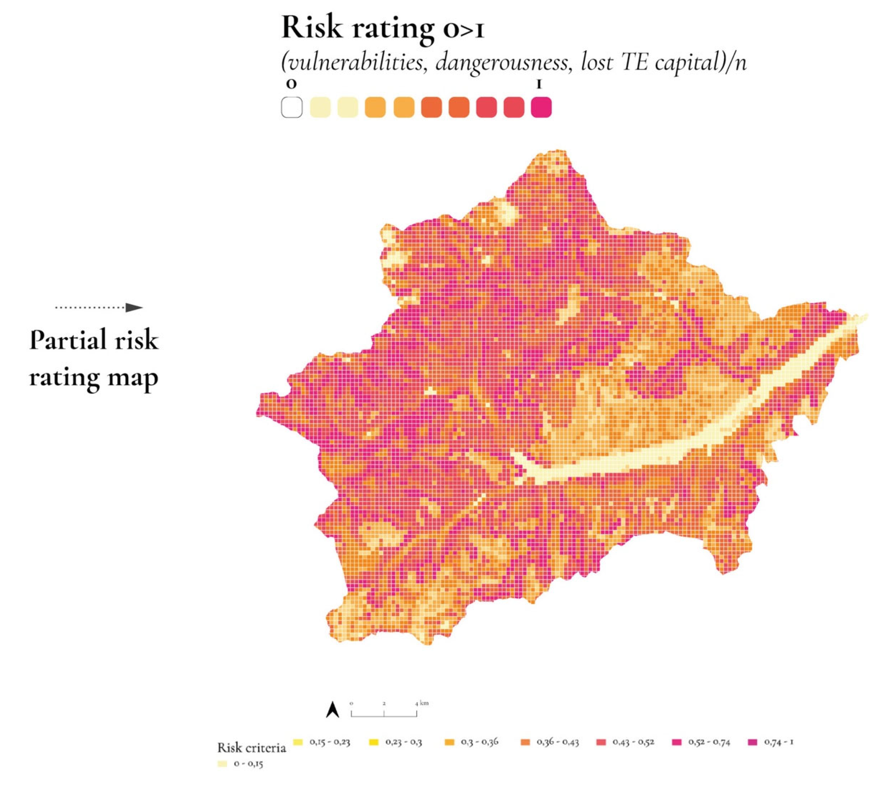
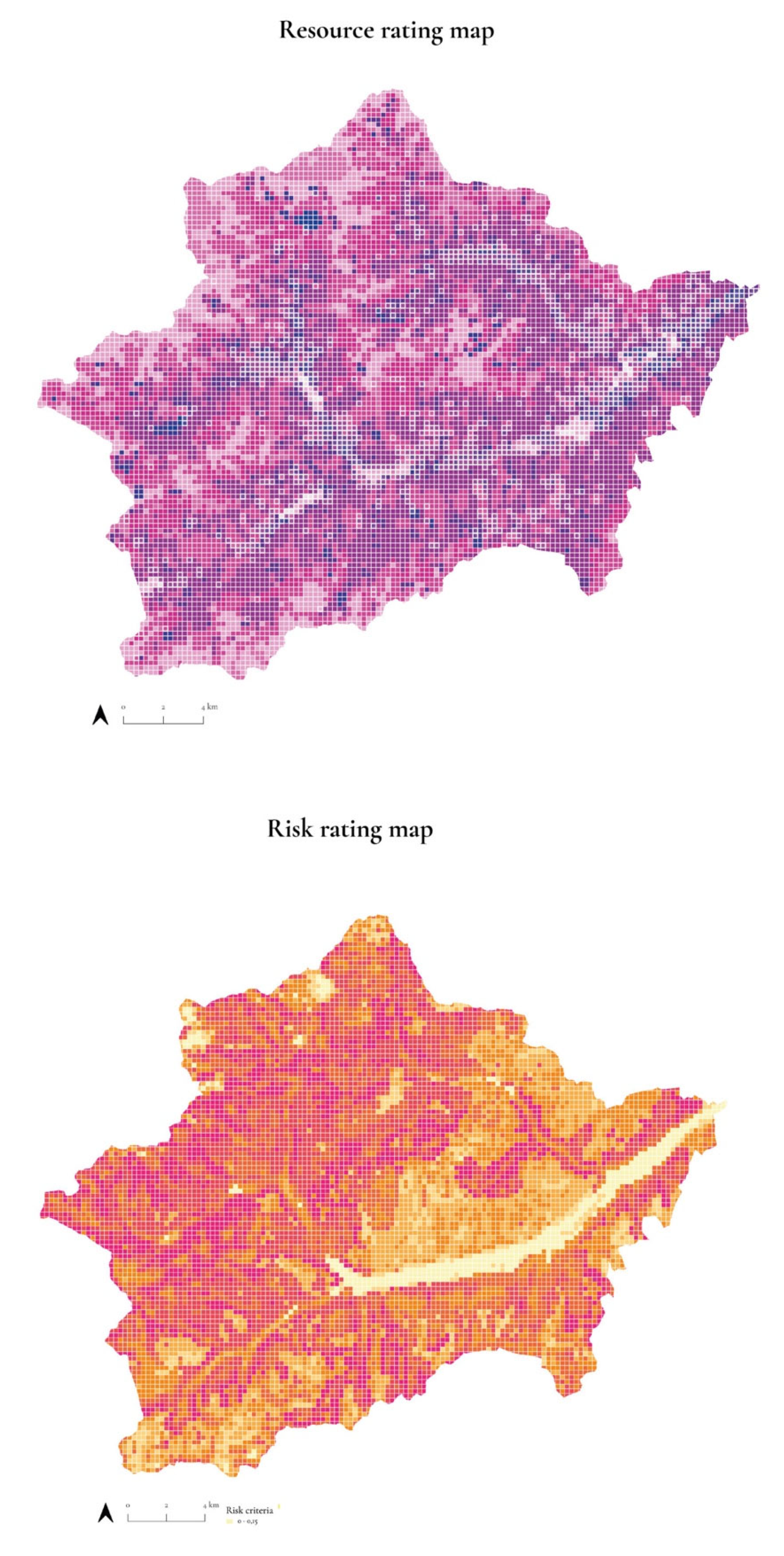
4.1.3. Selection of Spatial Values for Risk and Resource: GIS Assessment Approach

Many issues and levels analysed today are complicated. Often, these problems are spatial or geographic, so using GIS with different frameworks or analyses can assist decision making [2]. For this reason, it is necessary to introduce criteria that can be ranked according to a scale of values in order to sum or multiply individual binary preference maps. A mixed-methods approach was adopted to develop a risk and resource assessment approach for extreme territories criteria [28]. The proposed GIS-assessment approach is used to facilitate decision makers’ consideration of multiple criteria; moreover, it provides a logical process to follow to clearly identify different factors and prioritize them [29]. The choice to utilise an assessment approach within the mapping process is because it allows the level of risk and resource considered to be ranked in order of suitability for making the best possible decision. In this case, it is useful because there are a lot of data with conflicting interests, values, and goals. Therefore, here we choose to use GIS for data processing, which transforms and combines geographic data and value judgments to solve spatial problems: in addition, it considers geographic data models, the spatial dimension of evaluation criteria, and decision alternatives in evaluating criteria (to determine the relative weight/importance of risk and resource) [2].
Thus, each input can be weighted according to its importance or percentage of influence in the analysed context, according to the previously stated intention. Many of the problems people face are geographic in nature. Through the synergy between GIS and decision-making methods, spatial issues due to a large set of feasible alternatives and multiple, conflicting, and incommensurable evaluation criteria are reducible. Data reclassification with GIS-assisted multi-criteria evaluation [28] allows combining geographic data and value assessments to solve spatial problems [30].
The territory is analysed more specifically through the combined use of GIS and multi-criteria evaluation (the mapping tool and multidisciplinary interpretations such as multi-criteria assessment and matrices based on specific factors) [28] (Figure 7 and Figure 8).
Each selected criterion is re-parameterized according to a normalised scale (1 = high, 0 = low) relative to each factor’s risk and resource criterion. The goal is to visualise tangible factors, such as the natural environment, to understand their level of risk and resources in the development process of the Italian hinterlands. As mentioned above, studying Italian hinterland contexts means considering an apparatus of themes, issues, subjects, and policies accumulated over time. Cartographic practice is conveyed through multi-criteria assessment and analysis for its ability to influence and support decision-making processes, such as interactive and participatory maps. Following the developed investigation, the territory is investigated through multidisciplinary maps and interpretations. The multidisciplinary and multiscale approach highlights the different characteristics of informal settlements. Each spatial, analysed, and re-spatialized piece of data is given a reference code, a value of “Criteria Resource/Risk value 0 > 1“, to finally arrive at an overall reading of the context by summing the spatial elements for the two criteria analysed (Figure 8).

4.1.4. Mapping Application the Extreme Terres: The Tangible Space, Physical Terrain (Mapping)

The re-elaboration and categorisation of the data (2015–2021 GIS open data sources) takes place through the map tool, using the “Sémiologique Graphique” methodology [27]. The selected factors, belonging to the ecosystem categories anthropogenic and natural, are spatialized and re-parametrised as individual maps and then re-read in two critical maps, which focus on the relationship of the informal element with the risk and the resource [2]. “These elements are considered as parameters, factors with which to confront each other through a multi-criteria analysis. Each factor is identified as an element with different weight and gradients: the risk and the resource gradient.” [2]. At the end of this first process, it is possible to obtain two critical mappings, one representing the summation of the risk levels examined and another of resources (Figure 9).

4.1.5. Mapping Validation the Invisible Potential of Extreme Terres

After re-reading the context through the risk and resource criteria, the last step involves validating the initial hypothesis outlined in Section 2.2. The sum of the risk and resource criteria graded from 0 to 1 makes it possible to calculate which are the so-called Extreme Terres, i.e., those pixels of territory where the value of risk and resource are maximal on a scale of 0 to 1. In order to understand the difference between each re-parametrised portion based on risk and resource overlap, the parameter introduced at the beginning of the mapping process is used: la terre. Thus, each portion of soil, based on its composition and geolocation, will now have a specific risk and resource value assigned to it (Figure 10).

4.1.6. A Feedback Loop (Multi-Scale)

The feedback loop of the mapping process is the part of the system in which a portion (or all) of the output of the map system is used as input for future operations. During the first phase of the mapping process, the input is created during the factor selection phase. The input is captured and stored during the second phase, which is the application of the decision evaluating multiple criteria. During the third phase of critical maps, the input is analysed. During the fourth phase, that of validation of the Extreme Lands mapping, the understanding gained from the analysis is used to make decisions. As in any scientific process, feedback loops can be negative or positive, even within the input. In the case where feedback loops are negative, they are self-regulating and serve to maintain an ideal state (Figure 11).

5. Results of Val di Sole and Val di Rabbi Application Case

From the critical and theoretical reading of the context of Italian hinterlands, inland areas appear a place at risk of depopulation and hydrogeological risk where tourism is used as an economic engine to exploit parts of the local landscape resources in places that were characterised by extractive processes for raw materials for production processes (energy, marble, minerals, water).
Based on the parameters defined during the terre mapping methodology described at the beginning of the process, the mapping and data collection phase was characterised by in-depth research of information necessary to configure maps expressing the strong relationship between risk and resource in the Italian hinterlands. Through the mapping process, it is possible to highlight criticalities in a selected specific case, that of the Val di Sole and the smaller Val di Rabbi focus area: its existing resources and the presence of risk. The mapping process demonstrated and tested the interpretation of the potential of Extreme Terres in the marginal and alpine territory of Trentino, the one chosen as an application case. The description of the results obtained for the tangible mapping process of the Extreme Terres is the starting point for the subsequent phases of the doctoral research project that the “Extreme Terres of Anthropocene” thesis is pursuing.

5.1. The Val di Sole and Val di Rabbi Inner Territory: A Case Study

The inland area of Val di Sole (Figure 2) is mostly characterised by mountainous terrain with elevations up to 3757 m of Mount Cevedale/Zufallspitze and has numerous glaciers. For this reason, in the valley, territorial resources are closely linked to the morpho-geological characteristics of the soil: for example, the hot springs of Val di Rabbi and Val di Peio are a great resource for both the tourist and productive welfare system and the local population (Figure 12a).
In the past, the valley was marked by the shared culture of rural collective ownership. Today, water is one of the main sources of profit. Currently, only 3.5 percent of the area is covered by agricultural crops, about 22 percent by pastures, and 40 percent by forests. This change in the exploitation of the Solander territory has increased its fragility: in fact, pre-existing vulnerabilities responded differently to the extreme event of Storm Vaia, revealing a strong fragmentation of skills and knowledge in protecting against local hydrogeological risk. The partial abandonment of the Val di Sole and collective properties, centuries-old institutions in charge of managing portions of territories and perpetually bound to agro-sylvo-pastoral activities, has increased hydrogeological risk in the Solandro territory. In addition, the decentralised and peripheral location of the Val di Sole along with the fragmentation of the territory into small communities has made it difficult for valley-wide economic and spatial development interests and projects to take hold. This contribution focuses more on the case of closed collective properties, taking as an example the case of the Val di Rabbi, an inland area of the Val di Sole in the province of Trento, that can be considered an example of an Extreme Terre. The valley, following its population peak in 1951 (data from the Autonomous Province of Trento) has seen a continuous decline, but at the same time it is a destination for an increasing number of seasonal tourists, attracted by the hot springs and related services and the natural landscape, part of the Stelvio National Park.
In the valley, many mountain pastures, once managed by the inhabitants in the “consortele” system, are now replaced by natural reforestation and subject to hydrogeological risk. Consortele are collective co-ownerships that can be linked to the division of ancient feudal property, a key system in “maintaining a valuable balance between nature and human presence” [31] (p. 38). More specifically, the need for new pastures, expanded planting fields and water use led to the formation of groups that called themselves “consortele”: formed by owners or tenants of houses and land settled in different areas of the valley floor. These consortele had various rights and concessions over mountain territories: grazing rights, timber rights, and herbage rights [31] (Figure 12b).
As in other cases of collective property in the Alps [32], the territory is extremely sensitive to change due to exogenous forces and endogenous processes. Today’s key resources, spa tourism and the landscape of the Stelvio National Park, are a driver of economic development that is not necessarily synergistic with the maintenance of the local community and its traditional identity; for example, increased tourist flow could consume local natural capital and divert community resources from alpine maintenance practices. Looming over all of this is an uneven plurality of responsibilities, management and regulatory competencies, economic support capacities among municipalities, collective management consortia, tourism promotion companies, provincial services, a national strategy for inland areas, and multilevel governance, which in the misalignment of orientations and interventions may be an additional cause of fragility [33]. The conditions of environmental degradation and social vulnerability of the area are considered new opportunities: the slopes of the ravines become the perfect condition to establish rural ecological corridors to restore the soil and promote sustainable local production.

5.2. Data Exploration and Parameters Selection, The Val di Sole, Area Interna as Application Case: The Exploration of the Context

The first phase of exploration and data collection inherent to the chosen case study begins with data collection, both quantitative and qualitative, gathered during the exploration phase of the PRIN Branding4Resilience research regarding the Trento unit. The quantitative data were collected and ordered within a data catalogue by thematic dimensions, such as landscape and infrastructure, built heritage, economies and services and network services and community governance (Figure 13).
After the data collection, a process of data selection, quantitative or qualitative, was begun with the specific objective of the contribution: i.e., the investigation and identification of the extreme condition of the Italian hinterlands. This data selection phase, based on the map’s final intent, made it possible to select and map only those factors selected as necessary for the investigation. (Figure 14).

5.3. Mapping the Tangible Space of the Val di Sole

Testing the methodology for the Italian hinterland means testing the previously presented methodology on a case study chosen from among the Italian SNAI hinterland areas, such as the Val di Sole. After a careful selection of the factors that characterise the specific conformation of the Val di Sole (hydrological risks and hazards, thermal springs, hydroelectric energy, waterways, croplands and pastures, local community, land use, biodiversity, built heritage and natural capital) and having categorised the natural or anthropic ecosystem, the next step is to give a spatial and tangible value to the resources and risks of the territory. The risk, like the resource, if referred to as nature, is closely linked to the conformation of the territory: its orography, hydrographic system, climatic consequences, and soil degradation due to the over-exploitation of water, mining, forest and agricultural resources, have a more significant influence and increase the incidence of hydrogeological risk. Considering the risk of land abandonment, it becomes necessary to talk about space and its declinations. Throughout Italy, from north to south, it is possible to observe the dynamics afflicting inland territories. The survey conducted by the National Strategy for Inland Areas saw an increase in the number of natural disasters and abandonment by the local population living in small villages in marginal territories. The study shows a process of urban displacement through which the locals move towards the cities, in contrast to the flows of tourists invading the valleys.
The mapping process proposed for the Val di Sole application case offers to use the map as a critical tool able to give a spatial value to the single analysed elements of the Solandro context. For example, in Figure 12, it is possible to see the difference between static mapping and the assignment of spatial value through the definition of the resource criterion declined to the specific case: Criteria Resource equals the sum of the value of raw material, the production value, and the capital value of the Outer Lands on a scale of 0 to 1 (0 = low, 1 = high).
The first three maps (Figure 15) show the pure spatialisation of the waterways, lakes and springs in the Val di Sole. The use of classical cartography, albeit through the use of GIS, does not allow for a spatial value to be given to the resource under consideration but only for its spatial representation.
The contribution proposes a spatialisation of value by subdividing the entire area under consideration into pixels; using GIS tools, it is, in fact, possible to redefine the territory by dividing it according to an arbitrarily chosen grid. The subdivision of the territory into pixels makes it possible to attribute different values to each area of the surface considered; with the zonal statistics tool, the spatial value of risk and resource can be attributed to every single pixel for each categorised factor according to the criteria chosen by the evaluation analysis.
Figure 16 maps the same three factors present in Figure 12 to which the different resource values have been attributed according to the evaluation criteria; waterways, lakes, and springs have an additional value for each pixel according to the specific resource attributed to the area under consideration according to a scale of values distributed over the territory from 0 to 1. Here, the value graded from 0 to 1 of the resource criteria for the three selected factors takes into consideration the sum of the value of the raw material, the productivity level of the resource and its value as part of the capital of an Extreme Land.
The mapping, through the attribution of spatial values, makes it possible to calculate the resource level of complex systems: the hydrography shown in Figure 17 represents in the first map the pure superposition of the three spatial factors mapped in Figure 15. In contrast, the second mapping shows the sum of the spatialised elements according to the set value scale from 0 to 1, representing the spatial resource value for the Val di Sole hydrographic system.
The next step, visible in Figure 18, allows us to see how two maps made on the same numerical scale of values from 0 to 1 according to the assigned criteria can be summed up, and thus, how the surface examined can read a greater complexity of elements. Specifically, in the example in Figure 18, the slope and earthquake factors are spatialised according to the risk criterion on a scale of 0 to 1, whereby risk is the summation of the median value of vulnerability, hazard, and a capital loss of the Extreme Terrain for each factor.
After this calculation, it is possible to continue with the summation of the graded value of slope and earthquake risk and obtain an intermediate state map for the calculation of the overall critical risk criterion map in the Val di Sole.
The last step of the mapping and validation process for the Extreme Lands of the Italian hinterlands is carried out after obtaining the overall critical map of the risk and resource criterion for the territory of the Val di Sole application case. More precisely, in Figure 16, it is possible to distinguish the two overall critical maps and their summation for a value scale from 0 to 1, with the risk and resource level assigned to each pixel. The blue pixels of the third map in Figure 19 thus contains the portions whose maximum resource–risk ratio aspires to 1 and can be defined as Extremes.
On the other hand, the set of natural and social resources and the conformation of the territory are summarised in the critical mappings defined as Resource and Risk. The overlap of the two essential readings of the context, Risk and Resource, is evident in the mapping process, with a constant depopulation index, the extreme condition of this territory.

5.4. Exploring the Potentials of the Val di Rabbi for Intervention: A Strategic Taxonomy

This phenomenon shows a significant geographic concentration of resources and risk in the areas at higher altitudes and in the regions that were once used as alpine pastures, most of which are now disused. Comparing the final mapping of the Extreme Terres in Figure 19 for the Val di Sole with Figure 12a, it is possible to note that the recent abandonment by the local population of the Val di Sole and the consequent disappearance of sylvan-pastoral traditions has made these portions of land holding great resources visually more fragile.
Alpine abandonment has become a crucial risk factor due to the infrastructural disconnection of villages from services and densely populated settlement centres. This disconnection increases the evident dependence of towns in Italy’s interior areas on the city around which the service networks and systems are developed. Most alpine settlements, dedicated to sylvo-cultural activities, grew far from towns, within valleys or areas where lands rich in property and resources were maintained by awareness and care of pastures. The ancient care of the mountains is the context in which the ability to control and decrease today’s very high natural hazard risk, and is fast disappearing.
The mapping methodology proposed and applied to the case of the Val di Sole allows, through a jump in scales, to identify which portions of the land are most sensitive to endogenous and exogenous changes. For this reason and because of its strong conditions of hydrogeological risk and thermal and sylvo-pastoral resources, the Val di Rabbi, which is part of the internal area of the Val di Sole, is selected as the zoom area. By introducing the soil parameter presented at the beginning of the methodological process again, it is then possible to see how soil composition affects its resources and risk and to attribute each soil type to a different value ratio between risk and resource (Figure 20). Within the proposed methodological process, the most extreme is identifying the most sensitive parts of the terre. The mapping, validation, and identification of Pixels of Extreme Terres make it possible to identify areas to propose a multi-dimensional, multi-scalar ecological strategy, divided into different actions in time that recover the sylvo-pastoral and caretaking tradition of these interior territories.

6. Discussion and Perspectives

The conditions of environmental degradation and social vulnerability of the Italian hinterlands, especially the Val di Sole, are considered in this contribution as new opportunities: the slopes of the ravines become the perfect condition to recover and preserve the terre. Italian hinterlands must deal with instability, as they are situated in risky areas. As local populations live precariously and in continuous movement depending on the fickleness of nature in these areas, so the Italian hinterlands carry in them an awareness of their local knowledge as a “cultural landscape” [34].
Moreover, in these unstable conditions, “authorities managing risk could improve their strategic objectives if they could access and integrate” [35] (p.10) Italian hinterlands in urban planning information. “Furthermore, a collaborative hazard governance can provide equity to multiple urban actors that are usually left out of institutional DRM, including nongovernmental organisations, academia, and community groups.” [35] (p.10).
Thus, understanding the mixing of both nature and culture and ecology, territorial planning, and economic science allows us to create a model as a paradigm for ecological surveys and innovative management methods. Alternative models, such as cultural landscapes, should be integrated to address the contemporary overexploitation of resources and ongoing social imbalances. At the same time, a processual methodology is proposed to put these frameworks into a systemic approach that integrates economy with ecology and culture with nature. It is essential to consider the feasibility and eventual fallibility of the developed process [2].
From the point of view of the applicability of the proposed mapping methodology, we observe the necessity of understanding where the possible unbalances and richness of the territories involved come from. The capability of dialogue with the territorial planners, residents and workers using maps is essential to leave a tool to understand where and which ecological strategies should be proposed in such territories. Moreover, the proposed methodology is considered a process that cannot be replicated with actual results. Still, the conditions for establishing, each time, a new complex and endogenous thought are repeatable [2].

7. Conclusions

This paper presents a study that investigated Italian marginal territories using the integrated assessment approach of multi-criteria evaluation methods, multi-scalar spatial strategy, and GIS mapping.
The choice of this integrated approach makes it possible to not only obtain a georeferenced spatial analysis that is quantitative, but also to critically analyse and categorize spatial data into scales of values. The application case of the Val di Sole in Trentino is chosen to text and demonstrate the methodology proposed and will be the starting point for testing its replicability in different Italian hinterlands.

Author Contributions

This paper is to be attributed in equal parts to the four authors. M.P. and M.M., who have collaboratively contributed to its conceptualization, methodology, investigation and writing. Conceptualization M.P. and M.M.; methodology, M.P. and M.M.; investigation, M.P.; data curation, M.P.; writing—original draft preparation, M.P. and M.M.; writing—review and editing, M.P. and M.M.; visualisation, M.P.; supervision, M.M. All authors have read and agreed to the published version of the manuscript.

Funding

This research received no external funding.

Institutional Review Board Statement

Ethics approval is not required for the present study.

Informed Consent Statement

Informed consent was obtained from all subjects involved in the study.

Data Availability Statement

The data that support the findings of this study are derived from field research and resources available in the public domain. For other data sources analysed during the study see: ISTAT (2020), https://www.istat.it (accessed on 10 March 2021); Viabilità 2020 PAT, http://sdi-pat.provincia.tn.it/webgis/?bbox=595756,5044268,739244,5170732; Piano Urbanistico Provinciale PUP (2019) (aggiornamento Maggio 2022) http://www.urbanistica.provincia.tn.it/pianificazione/piano_urbanistico_provinciale/cartografia/pagina161.html; Geoportale Nazionale GPN http://www.pcn.minambiente.it/mattm/servizio-di-scaricamento-wfs/; Provincia Autonoma di Trento—Dipartimento Territorio Ambiente Energia e Cooperazione—Ufficio Sistemi Informativi, Geocatalogo PAT (2008, 2013, 2019, 2021) https://siat.provincia.tn.it/geonetwork/srv/ita/catalog.search#/home; Protezione Civile PAT http://www.protezionecivile.tn.it/territorio/Cartografia/cartografiatematica/-Cartografiaurbanistica/pagina2.html; Portale Geocartografico Trentino (CTP2017): http://www.territorio.provincia.tn.it/portal/server.pt/community/portale_geocartografico_trentino/254/portale_geocartografico_trentino/18994; Copernicus-CORINE LandCover (2018), https://land.copernicus.eu/pan-european/corine-land-cover/clc2018 (accessed on 22 December 2021); Borghi Autentici d’Italia, https://www.borghiautenticiditalia.it (accessed on 2 December 2021); Co- muni Italiani (2021), http://www.comuni-italiani.it (accessed on 23 December 2021); “TINITALY” DEM (2007), https://tinitaly.pi.ingv.it/; Servizio Gestione Strade PAT (2020), http://www.strutture.provincia.tn.it/Dettaglio_Strutture.aspx?cod_s=S106; OPENdata Trentino (2013), https://dati.trentino.it/; Azienda per il turismo delle Valli di Sole, Peio e Rabbi SCPA (2021), https://www.visitvaldisole.it/it/uffici-informazioni; Vivoscuolam (2021); Azienda Provinciale per i Servizi Sanitari PAT (2021), https://www.apss.tn.it/; OpenStreetMap (2021). https://www.openstreetmap.org/#map=6/40.007/-2.488. All links accessed on 1 July 2021.

Acknowledgments

I would like to express my sincere thanks to my supervisor, Sara Favargiotti, for her continuous support throughout my journey of research, growth, and direction in doctoral research. Who gave me the opportunity to be involved in the B4R Branding4Resilience project (PRIN 2017- Young line) the starting point of this contribution and to carry out my exchange period abroad. The deepening of the proposed methodology and the application to the case study were more developed during the internationalisation course held at the Institute of Advanced Architecture of Catalonia (IAAC) in Barcelona, under the supervision of Arch. Mathilde Marengo. I thank her for her guidance and invaluable help during my exchange course. This research project applied in author Margherita Pasquali’s doctoral dissertation “Extreme Terres” stems from a research project (Yuxtaposición Extrema, published by Maggioli 2019) carried out and developed with architect Carlotta Olivari, fellow at Architectural Association and Groundlab. The pathway on the evolution of soils in terre stems from a reflection with architect Caterina Rigo, which we are deepening with some of the contributions cited in the text and the author’s thesis. “DISPACE Landscape Architecture” is a collective research group founded by Carlotta Olivari and Margherita Pasquali in April 2018. The desire to investigate the relationship between nature and architecture in today’s environment leads us across our space”. “B4R Branding4Resilience. Tourist infrastructure as a tool to enhance small villages by drawing resilient communities and new open habitats’’ is a research project of national interest (PRIN 2017—Young Line) funded by the Ministry of Education, University and Research (MIUR) with a three-year duration (2020–2023). The project is coordinated by Maddalena Ferretti (Università Politecnica delle Marche) and involves the University of Palermo, the University of Trento and the Politecnico di Torino. For more information: www.branding4resilience.it. This paper gives a general overview, and it refers to a specific part of the PhD thesis: Pasquali, M.; “Extreme Terres of the Anthropocene”. University of Trento, Trento, Italy, 2020–2022, manuscript in preparation.

Conflicts of Interest

The authors declare no conflict of interest.

References

  1. Moore, J.W. Ecologia-Mondo e Crisi del Capitalismo. La fine Della Natura a Buon Mercato; Avallone, G., Ed.; Ombre Corte: Verona, Italy, 2015. [Google Scholar]
  2. Olivari, C.; Pasquali, M. (Un)Earth Chile. In New Metropolitan Perspectives; Springer: Berlin/Heidelberg, Germany, 2022; ISBN 978-3-031-06824-9. [Google Scholar]
  3. Ricci, M. New Paradigms; LISt: Campbell, CA, USA, 2012; ISBN 978-88-95623-53-5. [Google Scholar]
  4. Barca, F.; Casavola, P.; Lucatelli, S. Materiali Uval; Dipartimento per lo Sviluppo e la Coesione Economica: Rome, Italy, 2014. [Google Scholar]
  5. De Rossi, A.; Mascino, L. Sull’ Importanza Di Spazio e Territorio Nel Progetto Delle Aree Interne. In Aree Interne e Covid; Fenu, N., Ed.; LetteraVentidue: Siracusa, Italy, 2020; pp. 48–55. ISBN 978-88-6242-476-9. [Google Scholar]
  6. Tantillo, F. La Mutazione Delle Aree Interne, Da Margini a Nuova Frontiera. In Aree Interne e COVID; Fenu, N., Ed.; LetteraVentidue: Siracusa, Italy, 2020; pp. 34–44. ISBN 978-88-6242-476-9. [Google Scholar]
  7. Brenner, N.; Elden, S. Stato, Spazio e Territorio. Dialoghi Internazionali 2010, 14, 140–167. [Google Scholar]
  8. Pileri, P. Ius soli, urbis fortuna. In Suolo. Letture e Responsabilità del Progetto. Ediz. Illustrata; Quaderni del Dottorato; Officina: Rome, Italy, 2017; pp. 52–59. ISBN 978-88-6049-210-4. [Google Scholar]
  9. Pasquali, M.; Rigo, C. Valorizzare Il Suolo o Abitare La Terre? Una Visione Transcalare per Riconnettere Gli Habitat Marginali Nei Territori Marchigiani e Trentini. In Proceedings of the XXIV Conferenza, Brescia, Italy, 23–24 June 2022. [Google Scholar]
  10. Brenner, N.; Schmid, C. The ‘Urban Age’ in Question. Int. J. Urban Reg. Res. 2014, 38, 731–755. [Google Scholar] [CrossRef]
  11. Lanzani, A.; Zanfi, F. L’avvento dell’urbanizzazione diffusa: Crescita accelerata e nuove fragilità. In Riabitare l’Italia; Donzelli: Rome, Italy, 2018; pp. 123–140. [Google Scholar]
  12. Brenner, N.; Katsikis, N. Operational Landscapes: Hinterlands of the Capitalocene. Archit. Des. 2020, 90, 22–31. [Google Scholar] [CrossRef]
  13. Pasquali, M. Le Alpi Apuane: Un’antropogeografia tecnologica in risposta alla fragilità delle aree interne della Lunigiana. Polit. Reg. Coesione Aree Interne E Marginali Atti XXIII Conf. Naz. 2021, 3, 62–82. [Google Scholar] [CrossRef]
  14. Olivari, C.; Pasquali, M. Yuxtaposición Extrema; Maggioli Editore: Rome, Italy, 2019; Volume 24. ISBN 889163 8786.
  15. Barbera, F.; De Rossi, A. Metromontagna. Un Progetto per Riabitare l’Italia; Donzelli: Rome, Italy, 2021. [Google Scholar]
  16. Katsikis, N.; Brenner, N. Is the Mediterranean Urban? Walter de Gruyter GmbH: Berlin, Germany, 2013; pp. 428–459. ISBN 978-3-86859-893-3. [Google Scholar]
  17. Corner, J. The Agency of Mapping: Speculation, Critique and Invention. In Mappings; Critical Views: London, UK, 1999; p. 311. ISBN 1-86189-021-4. [Google Scholar]
  18. Mapping Parameters Overview. Available online: https://docs.informatica.com/data-integration/data-services/10-2/developer-mapping-guide/mapping-parameters/mapping-parameters-overview.html (accessed on 28 June 2022).
  19. Scull, P.; Franklin, J.; Chadwick, O.A.; McArthur, D. Predictive Soil Mapping: A Review. Prog. Phys. Geogr. Earth Environ. 2003, 27, 171–197. [Google Scholar] [CrossRef] [Green Version]
  20. Home Page—Branding4Resilience. Available online: https://www.branding4resilience.it/ (accessed on 28 June 2022).
  21. Malczewski, J.; Rinner, C. Introduction to GIS-MCDA. In Multicriteria Decision Analysis in Geographic Information Science; Malczewski, J., Rinner, C., Eds.; Advances in Geographic Information Science; Springer: Berlin/Heidelberg, Germany, 2015; pp. 23–54. ISBN 978-3-540-74757-4. [Google Scholar]
  22. Ferretti, M.; Favargiotti, S.; Lino, B.; Rolando, D. Branding4Resilience. Explorative and collaborative approaches for inner territories. Sustainability 2022, 14, 11235. [Google Scholar]
  23. Favargiotti, S.; Pasquali, M.; Chioni, C.; Pianegonda, A. Water Resources and Health Tourism in Val di Sole: Key Elements for Innovating with Nature in the Italian Inner Territories. Sustainability 2022, 14, 11294. [Google Scholar] [CrossRef]
  24. What Is Data Mining? Available online: https://www.techtarget.com/searchbusinessanalytics/definition/data-mining (accessed on 28 June 2022).
  25. Smallcombe, M. Structured vs. Unstructured Data: 5 Key Differences. Available online: https://www.integrate.io/blog/structured-vs-unstructured-data-key-differences/ (accessed on 28 June 2022).
  26. ETL vs. ELT: 5 Critical Differences|Integrate.Io. Available online: https://www.integrate.io/blog/etl-vs-elt/ (accessed on 28 June 2022).
  27. Bertin, J. Semiology of Graphics: Diagrams, Networks, Maps; ESRI Press: Redlands, CA, USA, 1967; ISBN 978-1-58948-261-6. [Google Scholar]
  28. Parizi, S.M.; Taleai, M.; Sharifi, A. A GIS-Based Multi-Criteria Analysis Framework to Evaluate Urban Physical Resilience against Earthquakes. Sustainability 2022, 14, 5034. [Google Scholar] [CrossRef]
  29. Greene, R.; Devillers, R.; Luther, J.; Eddy, B. GIS-Based Multiple-Criteria Decision Analysis. Geogr. Compass 2011, 5, 412–432. [Google Scholar] [CrossRef]
  30. Nimick, S.R. and E. Multi-Criteria Decision Analysis and GIS. Available online: https://storymaps.arcgis.com/stories/b60b7399f6944bca86d1be6616c178cf (accessed on 28 June 2022).
  31. Minora, F. Terre Comuni Percorsi Inediti Nelle Proprietà Collettive Del Trentino; LaFeltrinelli Internet Bookshop Srl.: Milan, Italy, 2012; ISBN 978-88-904295-9-0. [Google Scholar]
  32. Gretter, A.; Ciolli, M.; Scolozzi, R. Governing Mountain Landscapes Collectively: Local Responses to Emerging Challenges within a Systems Thinking Perspective. Landsc. Res. 2018, 43, 1117–1130. [Google Scholar] [CrossRef]
  33. Cash, D.; Adger, W.; Berkes, F.; Garden, P.; Lebel, L.; Olsson, P.; Pritchard, L.; Young, O. Scale and Cross-Scale Dynamics: Governance and Information in Multilevel World. Ecol. Soc. 2006, 11, 8. [Google Scholar] [CrossRef] [Green Version]
  34. Farina, A. The Cultural Landscape as a Model for the Integration of Ecology and Economics. Bioscience 2000, 50, 313–320. [Google Scholar] [CrossRef]
  35. Marten, R.; Abrassart, T.; Boano, C. Urban Planning and Natural Hazards Governance. Available online: https://oxfordre.com/naturalhazardscience/view/10.1093/acrefore/9780199389407.001.0001/acrefore-9780199389407-e-347 (accessed on 21 June 2022).
Figure 1. Terre parameter diagram” © “Extreme Terres of Anthropocene.” Margherita Pasquali’s PhD thesis, graphic elaboration M. Pasquali.
Sustainability 14 12641 g001
Figure 2. B4R Research Units and Inner Italian Areas” Coordination Sara Favargiotti, graphic elaboration Margherita Pasquali. ©Branding4Resilience—UNITN, 2020–2023.
Sustainability 14 12641 g002
Figure 3. “B4R Exploration processing data” graphic elaboration Margherita Pasquali. ©Branding4Resilience—UNITN, 2020–2023.
Sustainability 14 12641 g003
Figure 4. “B4R Trentino Unit Exploration taxonomy” graphic elaboration Margherita Pasquali. Data sources: ISTAT (2020), CTP (2017), “TINITALY” DEM (2007), Servizio Gestione Strade PAT (2020), PUP (2019), Geoportale Nazionale (2013); Mapping and diagram credits: Coordination Sara Favargiotti, graphic elaboration Chiara Chioni and Margherita Pasquali. ©Branding4Resilience—UNITN, 2020–2023.
Sustainability 14 12641 g004
Figure 5. How to collect data.” Extreme Terres of the Anthropocene.” Margherita Pasquali’s PhD thesis, graphic elaboration M. Pasquali.
Sustainability 14 12641 g005
Figure 6. How to process data.” © “Extreme Terres of Anthropocene.” Margherita Pasquali’s PhD thesis, graphic elaboration M. Pasquali.
Sustainability 14 12641 g006
Figure 7. Spatial factors.”, © “Extreme Terres of Anthropocene.” Margherita Pasquali’s PhD thesis, graphic elaboration M. Pasquali.
Sustainability 14 12641 g007
Figure 8. Data reclassification: GIS assisted multi-criteria evaluation”, © “Extreme Terres of the Anthropocene.” Margherita Pasquali’s PhD thesis, graphic elaboration M. Pasquali.
Sustainability 14 12641 g008
Figure 9. GIS assisted multi-criteria evaluation synthesis maps.”, © “Extreme Terres of the Anthropocene.” Margherita Pasquali’s PhD thesis, graphic elaboration M. Pasquali. Supervision M. Marengo.
Sustainability 14 12641 g009
Figure 10. Critical maps.”, © “Extreme Terres of Anthropocene.” Margherita Pasquali’s PhD thesis, graphic elaboration, M. Pasquali. Supervision, M. Marengo.
Sustainability 14 12641 g010
Figure 11. Feedback loop.”, © “Extreme Terres of Anthropocene.” Margherita Pasquali’s PhD Differently, positive feedback loops merely repeat past actions that have proven successful, making the process continuous.
Sustainability 14 12641 g011
Figure 12. (a) Val di Sole framework.” © “Extreme Terres of the Anthropocene.” Margherita Pasquali’s PhD thesis, mapping and graphic elaboration M. Pasquali. Sources: Open Data Trentino, Webgis PAT, Protezione Civile, GPN. (b) “Val di Rabbi framework.” © “Extreme Terres of the Anthropocene.” Margherita Pasquali’s PhD thesis, mapping and graphic elaboration M. Pasquali. Sources: Open Data Trentino, Webgis PAT, Protezione Civile, GPN.
Sustainability 14 12641 g012aSustainability 14 12641 g012b
Figure 13. Val di Sole and Val di Rabbi data collection.” © “Extreme Terres of the Anthropocene.” Margherita Pasquali’s PhD thesis, mapping and graphic elaboration M. Pasquali.
Sustainability 14 12641 g013
Figure 14. Val di Sole and Val di Rabbi data process.” © “Extreme Terres of the Anthropocene.” Margherita Pasquali’s PhD thesis, mapping and graphic elaboration M. Pasquali. Supervision M. Marengo.
Sustainability 14 12641 g014
Figure 15. Val di Sole and Val di Rabbi waterways, lakes and springs.” © “Extreme Terres of the Anthropocene.” Margherita Pasquali’s PhD thesis, mapping and graphic elaboration M. Pasquali. Sources: Open Data Trentino, Webgis PAT, Protezione Civile, GPN © “Extreme Terres of the Anthropocene.” Margherita Pasquali’s PhD thesis. Supervision M. Marengo.
Sustainability 14 12641 g015aSustainability 14 12641 g015b
Figure 16. Val di Sole Tangible spatial data value of waterways, lakes and springs GIS-assisted multi-criteria evaluation.” © “Extreme Terres of the Anthropocene.” Margherita Pasquali’s PhD thesis, mapping and graphic elaboration M. Pasquali. Sources: Open Data Trentino, Webgis PAT, Protezione Civile, GPN © “Extreme Terres of the Anthropocene.” Margherita Pasquali’s PhD thesis. Supervision M. Marengo.
Sustainability 14 12641 g016aSustainability 14 12641 g016b
Figure 17. Val di Sole cartography and the tangible spatial data value of the hydrographic system.” © “Extreme Terres of the Anthropocene.” Margherita Pasquali’s PhD thesis, mapping and graphic elaboration M. Pasquali. Sources: Open Data Trentino, Webgis PAT, Protezione Civile, GPN © “Extreme Terres of the Anthropocene.” Margherita Pasquali’s PhD thesis. Supervision M. Marengo.
Sustainability 14 12641 g017
Figure 18. Val di Sole tangible spatial data value of the risk GIS-assisted multi-criteria evaluation.” © “Extreme Terres of the Anthropocene.” Margherita Pasquali’s PhD thesis, mapping and graphic elaboration M. Pasquali. Sources: Open Data Trentino, Webgis PAT, Protezione Civile, GPN © “Extreme Terres of the Anthropocene.” Margherita Pasquali’s PhD thesis. Supervision M. Marengo.
Sustainability 14 12641 g018aSustainability 14 12641 g018b
Figure 19. Val di Sole Extreme Terres.” © “Extreme Terres of the Anthropocene.” Margherita Pasquali’s PhD thesis, mapping and graphic elaboration M. Pasquali. Sources: Open Data Trentino, Webgis PAT, Protezione Civile, GPN, © “Extreme Terres of the Anthropocene.” Margherita Pasquali’s PhD thesis. Supervision M. Marengo.
Sustainability 14 12641 g019aSustainability 14 12641 g019b
Figure 20. Val di Rabbi pixels of Extreme Terres.” © “Extreme Terres of the Anthropocene.” Margherita Pasquali’s PhD thesis, mapping and graphic elaboration M. Pasquali. Sources: Open Data Trentino, Webgis PAT, Protezione Civile, GPN © “Extreme Terres of the Anthropocene. Margherita Pasquali’s PhD thesis. Supervision M. Marengo.
Sustainability 14 12641 g020
Publisher’s Note: MDPI stays neutral with regard to jurisdictional claims in published maps and institutional affiliations.

