Article

Mining-Induced Anthropogenic Transformations of the Wielka Kopa Massif—Case Study of Rudawy Janowickie, the Sudetes

by
Magdalena Duchnowska
Faculty of Geoengineering, Mining and Geology, Wroclaw University of Science and Technology, Wybrzeże Wyspiańskiego 27, 50-370 Wroclaw, Poland
Sustainability 2022, 14(2), 874; https://doi.org/10.3390/su14020874
Submission received: 27 November 2021 / Revised: 24 December 2021 / Accepted: 11 January 2022 / Published: 13 January 2022

Abstract

:
The article presents a detailed description of the transformation of the terrain relief due to long-lasting underground and surface mining activity in the Wielka Kopa massif at Rudawy Janowickie (the Western Sudetes mountains). It includes both the anthropogenic forms and secondary transformations of these forms due to natural land-shaping processes, ongoing after mining had been discontinued. The location deserves special attention, as it shows particularly significant mining-induced relief transformations, whose scale can be compared to those of the Walbrzych hard coal basin and the Turoszow lignite basin. The presented object is also an important historical heritage and deserves special attention due to its high research, didactic and tourism potential. The article offers a description of the characteristics and a classification of the anthropogenic forms in the area of Wielka Kopa, which are hoped to serve as an aid in planning future actions related to the revitalization of the area and also as an example for future descriptions of other closed mining facilities.

1. Introduction

Surface mining is one of the economy branches which have a strong impact on the natural environment. Mining-related transformations usually have an irreversible or long-lasting character and often cause a number of negative processes even after extraction is discontinued. Mining activity entails changes in the morphology and geology of the mining area. Hydrogeological, soil and even climate conditions change as a result of terrain relief transformations. Additionally, as the deposit is developed and mined, the fauna and flora of the region are transformed, causing changes or even in some cases the degradation to the ecosystem [1]. Abandoned post-industrial mining areas are an important source of environmental problems. However, in many cases such facilities are also an important historical heritage and in many countries, they are therefore protected by various legal regulations [2].
Anthropogenic transformation of the environment is the result of human interference in the relief of the land, which leads to the formation of new landforms [3]. Large-scale transformations of landforms are an inherent and most easily observable effect of mining activities. The shape and extent of the forms that arise as a result of these processes depend on the scale and manner of mining and landforms, as well as on the enrichment technology. Open pits and accompanying heaps are most frequently associated with surface mining. The forms related directly to underground mining activities include mainly large-scale deformations of the land surface, both continuous (subsidence troughs) and discontinuous (such as fissures, clefts, sinkholes and funnels) [4]. This issue is complex and has been repeatedly discussed in the literature in relation to various human activities. Thus, one can see transformations in urbanized areas [5,6,7,8] or caused by mining activities [9,10,11,12,13]. Undoubtedly, land use and land cover not only reflect human activities but also influence climate [14]. Land transformation due to human activities can disrupt biogeochemical cycles and affect the vulnerability of people and infrastructure to various natural hazards [15,16].
Mining facilities may be treated as a special type of post-industrial areas, which includes architectural features, as well as landscape features related to geology, geomorphology or topography. The need to develop economic activity in locations which were traditionally dependent on the “mining monoculture” led to a cultural revival in some of such areas [17]. On the other hand and from an environmental perspective, old mining facilities, especially those not extensively revitalized, may be a potential threat to the areas in the vicinity. The abandoned forms left by mining and mineral-processing activities are subject to geomorphological processes, such as mass movements [18], and in addition minerals accumulated in the old spoil heaps are exposed to chemical and physical weathering processes—for example in acidic environments some of the elements, such as heavy metals, may be transferred to the groundwater layers [19]. The main problem in post-mining industrial areas is the influence on the natural environment, as well as on the social and economic environment [20].
The potential of old mineral mining facilities is being increasingly recognized and used for completely different purposes [21,22]. Traditional reclamation in the forest or aquatic direction is consciously abandoned in favour of works aimed at developing the facilities to serve various tourist functions [23,24,25]. Old mining objects deserve special attention due to their high research, educational and tourism values [2]. While developing this new economic potential, however, attention must be paid to the environmental risk, especially in the locations where sulfide minerals were mined and therefore the concentration of heavy metals is very high and accompanied by chemical weathering processes [17].
The purpose of revitalizing post-mining facilities is to preserve the mining-related cultural heritage, and in effect—to increase the attractiveness of the region [2,26]. In Poland, these issues are regulated by the Revitalization Act, which provides a complex description of the stages and methods of revitalization. The goals of revitalization may include the reclamation and development of post-industrial areas. In the case of the mining plants currently in operation, the reclamation of the post-mining area is the duty of the mining company, while the formal and legal aspects related to the reclamation of post-mining areas are mainly regulated for active mining areas. They do not apply to the areas where mining activity has been long discontinued and never followed by the reclamation and management of the area. Such areas are the property of either private individuals or the State (local government). The revitalization-related tasks (including the reclamation and development) remain the duty of these institutions. However, mining companies currently in business are responsible for reclamation in accordance with the Geological and Mining Law [27] and the Law on the Environment Protection [28]. Additionally, in order to provide the objects with practical values, an investor is needed: a mining entrepreneur or company, a local government unit, the State Treasury or a third person (e.g., a private individual or a company) which will develop the reclaimed area [2]. The selection of the best development method, and thus of the reclamation method as well, requires many aspects, not only legal ones, to be taken into consideration [25,29,30]. One such aspect are social preferences related to the perception of the post-mining site as an attractive area, and to its social acceptance, but also to the terrain shape and the rate of ecological succession [21]. Nevertheless, the reclamation process will be impossible without fully characterizing the anthropogenic transformations of an area. And this characteristic is what should become the basis for further actions. Mining activity effects a change not only in the terrain relief, but also in all the components of an ecosystem. Changes in the physics and hydrology of the soil result in disturbed hydrogeological conditions and have a significant influence on the characteristics of the surface run-off [31]. Steep mining slopes and heaps which do not undergo a complete ecological succession are prone to intensive erosion [32]. Unweathered solid rock exposed in the area of the mining excavations show increased susceptibility to mass movements than the slopes in the pre-mining landscape [33]. Therefore, the ecology of the post-mining landscape cannot be identical to the ecology in the pre-mining conditions. However, experience teaches that the value of the revitalized areas may be significantly higher than the value of pre-mining areas.
The issue of applying geomorphic principles to the reclamation of mines is being increasingly raised. The objective is for the “mining landscape” to be revitalized in such a manner that it performs functions similar to the natural geomorphic system. The new system should be possibly best adjusted geomorphically to the new post-mining conditions. This approach requires the lengths, angles and shapes of the slopes in the new landscape to be similar to those in natural systems based on geomorphic principles [34], and to conform to the requirements making the revitalized areas suitable for practical use [24]. By including these aspects in the revitalization plans, it may be possible to ensure the proper functioning of the existing ecosystems and increase the success chances of the revitalization project [18], while an informed revitalization of post-mining areas will contribute to an increased attractivity in both the economic and social dimension.
The article presents the characteristics of terrain relief transformations due to surface and underground mining production from a deposit of pyrite-bearing sericite-chlorite shales in the Wielka Kopa massif. It includes a classification of anthropogenic forms with a division into forms and objects created intentionally, such as surface excavations, heaps, slopes and other secondary forms: screes, sinkholes, depressions, ground fissures and deluvial cones. It also includes an evaluation of the changes which have occurred in the area since the start of the mining operations and until the present state, as well as an evaluation of whether the individual elements are properly located against the terrain relief, geology and the history of local mining activity. The present study may indicate directions for further activities related to the revitalization processes in the area, as well as to provide an example on how to describe closed mining facilities.

2. Materials and Methods

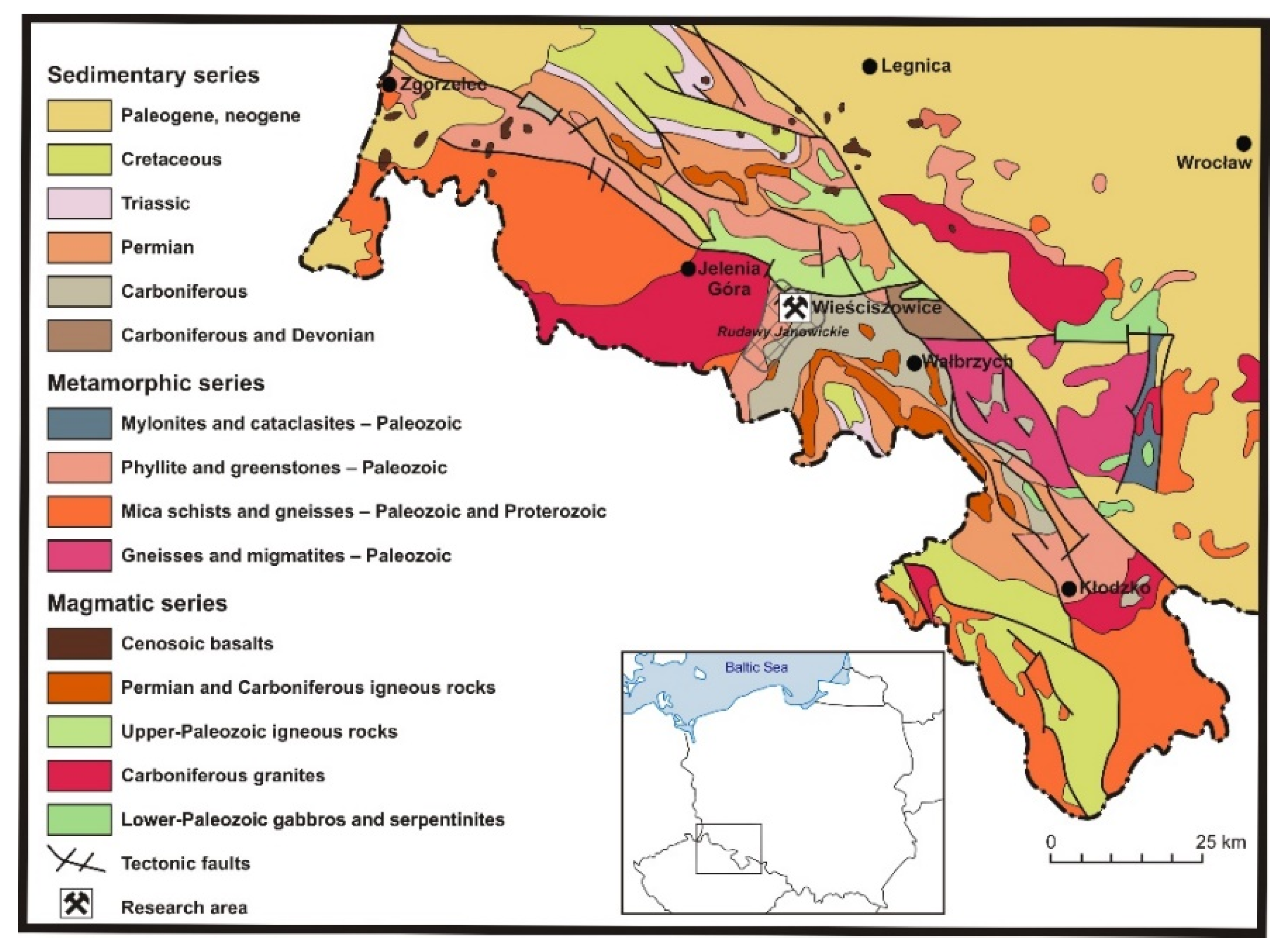
2.1. Description of the Study Area

The Wielka Kopa massif is located in the north-eastern part of Rudawy Janowickie (the Western Sudetes mountains, Poland) (Figure 1). At the end of the 18th century the area was discovered to have a polymetallic deposit of pyrite-bearing shales and soon their extraction started. The mining works resulted in the construction of open-pit excavations and adits. After the mining operations were closed, the excavations were filled with water, which started to dissolve the ground rocks and was dyed with various colours. Hence the complex is referred to in the literature as “Colorful Lakes” and consists of Purple, Blue and Green Lake (historic German names of excavation: Hoffnung, Neues Glück and Gustav Grube) [19].
The Wielka Kopa massif comprises several ridges which meet in a culmination located at 871 m a.s.l. The slopes of this form are relatively steep (inclined at approx. 30–35°) and cut by deep valleys, among others of the Rdzawy Potok stream. Significant natural assets caused the area to be included in the Rudawy Landscape Park. In 2014, the area including the former pyrite excavations was used to prepare a didactic trail. The area is additionally part of the Natura 2000 region [36]. The study area is well connected to the main centres of the region, which has a positive impact on its tourist attractiveness.
Geologically, the rocks form a part of the metamorphic cover of granite in the Karkonosze mountains and together with it they form the Karkonosze-Izera massif. The unit is a north-eastern part of the extension of the Saxony-Thuringia zone [37]. Due to its complicated structure, the metamorphic granite cover of the Variscan Karkonosze massif has been addressed in a number of research works from the fields of tectonics and lithology [38,39,40,41], which attempted its classification. In most of the publications, the former pyrite-bearing shale extraction area belongs to the Leszczyniec unit. This unit comprises igneous and plutonic rocks enriched with sodium [42], transformed due to multi-phase metamorphism. Originally it was a high-pressure metamorphism of the subduction zone, and this was followed by thermal metamorphism, and finally by regional metamorphism [38].
The pyrite-bearing shale deposit extends in a narrow strip approx. 200 m in width and approx. 4.5 km in length, from the Wiesciszowice village in the north to the Pisarzowice village in the south. The deposit series is formed by layers of various lithology types of quartz-sericite-chlorite shales several tens of centimetres in thickness [43]. The floor of the deposit is formed by weakly laminated quartz rocks having various hardness. The proper deposit series is located above this layer and is formed of alternately arranged chlorite, sericite and sericite-chlorite shales. The rocks which form this series are characterized by weak lamination, limited hardness (locally, they are strongly weathered) and by varying pyrite content. The roof of the series is formed of strongly layered chlorite shales [44]. The layers which form the deposit incline mainly in the western direction, at an angle of 30–70°. The ore mineral of the deposit is pyrite, which is found in the form of grains up to 2 mm in diameter. Its content in the deposit is at an average of 10.9%. The balance resources of pyrite in Wiesciszowice are 3.911 thousand metric tons, while the non-balance resources are 209.442 thousand metric tons. Apart from pyrite, the deposit was found to contain such minerals as sphalerite, bornite, galena and chalcopyrite [45].
From the hydrogeological perspective, the discussed area is part of the Rdzawy Potok drainage area. The groundwater table in the region of the deposit varies and depends on the season of the year and atmospheric precipitation levels in individual months. The inflow of groundwaters to the excavations increases in the northern direction, a phenomenon related to the presence of artesian waters in the area [34]. The waters in the area may be classified as sulfur-lime-magnesium mineralized waters with high content of iron and copper ions (the region belongs to the sulfide oxidation zone). Trivalent iron ions are responsible for the red colour of the waters of the Rdzawy Potok stream and Purple Lake (Hoffnung excavation), while copper ions give the emerald colour to Blue Lake (Neues Glück excavation) and Green Lake (Gustav Grube excavation) [46]. The original names of the excavations are in brackets because before World War II the area was part of Germany.
Considering the historical aspects and the complex nature of the analysed area, one can see the high environmental and cultural potential of this site. The ecosystem changed as a result of mining activities and the mining relics left behind indicate the need to protect them while exposing their high values.

2.2. Extraction History of Pyrite-Bearing Shale Deposit in the Region of Wiesciszowice

In the 18th century and at the beginning of the 19th century, pyrite was the main ingredient necessary in the production of sulfuric acid. The majority of pyrite in European markets was extracted in Spain. In the middle of the 18th century, a polymetallic deposit of pyrite-bearing shales was discovered and subsequently extracted in the area of the Wielka Kopa massif (Rudawy Janowickie). The extraction works resulted in the construction of a large complex of open-pit excavations and adits [47].
The extraction works on the deposit started in 1785 by developing the Hoffnung open pit, which was located approx. one kilometre from the centre of the then German village named Rohnau (today’s Wiesciszowice). In 1793 another excavation, Neues Glück, was built south of the previous pit, and then, in 1796, the Gustaw extraction was started at a height of approx. 730 m a.s.l. [45].
The operation of the mine can be divided into two periods. The first period started in 1785 by opening the deposit, and finished in 1892, when the mine was closed for the first time due to insufficient profitability caused by low sulfur prices in the global markets. In 1872, both the mine and the processing plant in Plaszow became the property of the “Silesia” chemical company from Zarow. The products of the company included, among others, oil paints from sulfuric acid, which was the reason to build a narrow-gauge railway to the neighbouring Marciszow (a village along the Jelenia Gora-Zarow-Wroclaw railway) in order to transport the mined material to that location [48]. The second period of the mining operations started in 1904, when the processing plant was modernized and allowed higher sulfur output from the deposit. This second period finished in 1925, when the mining works were discontinued as the demand in global markets was satisfied by cheaper pyrites from Spain [49]. Despite their relatively small area, if compared to the Spanish pyrite mines, the closure of the Wiesciszowice mine generated similar economic, social and environmental problems to those encountered in Spain [17]. Figure 2 shows compared views of the slopes of the Wielka Kopa massif from 1907, when the operations were still active.
The Wiesciszowice pyrite was of high quality, as it did not contain arsenic or zinc impurities. At the processing stage, after mechanical classification and fragmentation, the mined ore was separated using the thin stream separation method. This was a very expensive process (20% of the turnover was consumed by delivering water to the gravitational enrichment system) and significantly increased the price of the obtained raw material [45]. The enriched concentrates were processed into Fe, Cu and S used in the production of sulfuric acid (H2SO4). Between 1852 and 1925, local production reached 200,511 metric tons of concentrate with 47% sulfur content [19]. Table 1 lists quantitative parameters of the ore dressing process [49].
As the pyrite and the gangue had significantly different densities, the feed could be efficiently enriched by gravity in the jet separators. Figure 3 shows the results of own research based on gravitational enrichment in a concentrating table of specimens of the rocks from the deposit, collected in four different locations of the Hoffnung pit and also based on previous research by Duchnowska [52]. The specimens subjected to the enrichment processes show good selectivity of heavy metal enrichment in the concentrate, dominated by pyrite and also copper sulfates. In the future and on condition that it becomes the object of thorough research analyses, the comminuted material stored in the heaps may serve as a potential source of useful minerals. However, the material deposited in the heaps should be properly protected from illegal extraction as a source of sands and gravels, which is currently a common problem.
The materials presented in this article are the result of in-field research and study visits, with the methodology being based on the results obtained as a result of charting the geomorphology of the area, analysing archival materials and photographic documentation.
The charting of the geomorphology consisted in the precise marking of the forms, on the 1:1000 topographic map being part of the geological documentation of the deposit, as well as of the geomorphological objects and the range of the processes observed in the region. During the charting process, additional sketches were also prepared, as well as notes describing individual forms and processes. The morphometric measurements of individual forms were performed with the measuring tape, the geological compass and the range finder.
The analysis of the archival materials consisted in collecting old German maps (1:25,000 Messtichblatt) and old German photographs, and in comparing them with the maps made and photographs taken in the post-war Poland. The intensity of the geomorphological processes and their seasonal variability were analysed on the basis of photographic documentation collected over a period of one year. The results served to prepare a situational map of the northern slopes of the Wielka Kopa massif based on the 1:1000 land survey and height map of the pyrite-bearing shale outcrop in Wiesciszowice made in 1955 and included in the geological documentation of the deposit.
The mining and processing related terrain relief forms in the area were classified into two groups, as intentional forms and as secondary forms due to natural land-shaping processes. Table 2 shows the landforms included in the analysis, classified on the basis of [53,54].

3. Results

3.1. Mining-Induced Anthropogenic Transformations—Intentional Terrain Relief Forms

3.1.1. The Purple Lake Complex (Purple Lake and Yellow Lake)

The Purple Lake complex (Figure 4) is located in the part of the deposit which has the highest pyrite grade. Due to long-lasting ore extraction, the borders of the Purple Lake complex extended to 800 m in length and 400 m in width: a deep excavation was formed with wall heights reaching 150 m. It is surrounded by a group of large heaps. The excavations were constructed as open pit mine slopes. The excavation can be classified into two parts: the northern part today called Yellow Lake and the southern part (the main excavation), which today includes Purple Lake. The two parts are separated with an outlier rock.
The shape of the Yellow Lake bed (located at the height of 546 m a.s.l.) resembles a rectangle 35 m by 23 m. It is surrounded on all sides by steep stone slopes having an inclination of up to 50–60° and a height of approx. 20 m. In the bottom of the pit, at its western wall, a smaller excavation was constructed. It has an oval shape and a diameter of 17–18 m. It is currently flooded by precipitation water and groundwater.
The outlier rock which separates the excavation from the main excavation is most probably a fragment of an old mining bench. The relative height of the outlier is approx. 14 m, and the wall inclination reaches 70°. This landform is penetrated by three drifts. The first is a cross-heading constructed in the northwestern part of the outlier. It is approx. 2.5 m high, 4.1 m wide and 14.3 m long. The second drift connects the northern and the southern excavations. It is approx. 3 m high, 2 m wide and 20 m long. The location of the two drifts is interesting: in the top view they extend almost in parallel, and even more interestingly, they were most likely connected by a cross heading. The entry to the cross heading, albeit closed with rock, is visible on the eastern wall of the outlier. The height of the closed opening is approx. 2.7 m, and its width is approx. 2 m.
The floor of the main excavation fills Purple Lake and extends in the N-S direction. Its length is approx. 400 m and its width is approx. 120 m. The bottom of the excavation is inclined from south to north, from the level of 599 m a.s.l. to the height of 542 m a.s.l. The excavation walls are steeply inclined at up to 80°, especially in the locations where the slopes extend in parallel to the layers of the slope-forming shale rocks. In the eastern part, the wall heights reach 120–150 m, in the western part—approx. 30 m, in the southern part—13 m, and in the northern part the wall height is approx. 35 m. Fragments of old mining benches visible in the walls are a characteristic feature of the discussed open pit. The area includes approx. eight such benches, which divide slopes at an inclination of approx. 70°. The first and highest bench is 10 m below the top slope of the excavation, at a height of 603 m a.s.l. Further benches are at the following heights: 600, 592, 580, 570, 560, 552, 542 m a.s.l. Some of the benches still contain unmined outliers and small spoil banks. One of the higher benches (600 m a.s.l.) has an entry to the dip heading.
The Purple Lake complex excavation is very narrow in the southern part, and extends to approx. 45 m in the northern part. The total length of the bottom in the main pit is approx. 240 m. A water shaft was drilled in its western part (the entry is located under the water surface). The shafts extends under a heap located in the northern part of the complex and exits below the heap. In the western wall of the excavation, in the vicinity of its bottom at 648.5 m a.s.l., another adit was constructed with a length of 130 m and a height of approx. 2 m. A small stream exits from the adit, and it discharges to Purple Lake at a distance of approx. 12 m.
Two types of spoil heaps can be distinguished in the area of the Hoffnung excavation: a coarse-grain heap located in the western part of the main excavation and a fine-grain heap located in the southern part of the complex. The heaps of the first type were most probably formed of the overburden material or of a low-grade material with pyrite content insufficient for economic processing. The second type of heaps, on the other hand, were formed of post-processing tailings.
The coarse-grain heap extends in parallel to the main excavation. On the east, it is surrounded by the slope of the main excavation, and on the west—by a high slope inclined at up to 45° and up to 44 m in height. Its length is approx. 330 m and its maximum width is approx. 160 m. The roof of the heap is formed by levelled surfaces arranged in steps (descending towards the north).
An old post-mining object is located on the western side of the spoil heap, but its function cannot be determined with certainty. In its front and side views, the form resembles a truncated cone, and in its top view, it is annular. The cone is formed of soil material additionally reinforced with stone blocks, which probably served to protect the inside of the form against collapse (if assumed that it was a small shaft) or to increase the strength of the walls against explosive materials. During mining operations, blasting materials needed to be stored in adequately prepared rooms (Figure 5). In order to increase the work safety, the walls of such rooms had high strength and the roof structure was lightweight so that the blast wave would be directed upwards rather than to the sides.
Another heap was formed of fine-grain material at a distance of approx. 30 m from the southern heap. This form reaches the level of 508 m a.s.l. and is approx. 24–30 m in height. Its length is approx. 340 m and its width is approx. 205 m. On the west and on the south the heap is surrounded by slopes up to 30 m high. The slope inclination is on average approx. 35° and is similar to the natural slide angle of the sand. At locations where its material was compacted or where it is being extracted, the inclinations reach 50°.

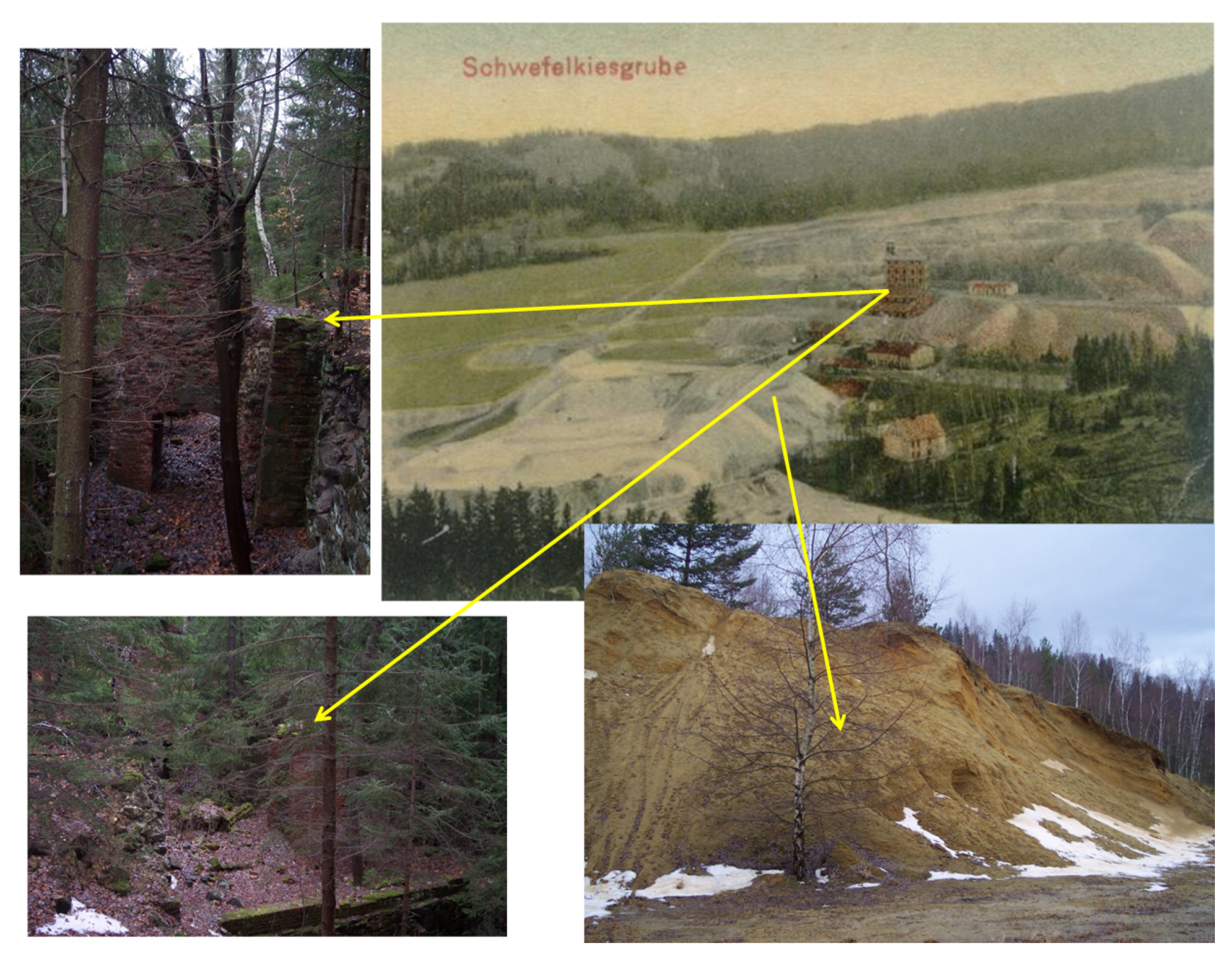
3.1.2. The Blue Lake Complex (Neues Glück Excavation)

The Blue Lake complex was constructed after a sudden increased demand for sulfuric acid in the raw material markets. It consists of three main elements: the main pit, a system of heaps and a smaller excavation located north-east of the main pit (Figure 6).
The shape of the main pit is similar to an ellipse, its longer axis being approx. 78 m in length and the shorter axis—63 m in length. The bottom of the pit is located at approx. 620 m a.s.l. In the north-eastern part of the excavation, a water gallery was built under the adjacent heap and under the terrain surface. During the mining operations, the gallery served to dewater the excavation, and today it is partially filled with rock material. The gallery extends horizontally in the north-western direction, along the length of approx. 50 m. In the exit part, the height of the water gallery is approx. 0.7 m, and its width is approx. 1.8 m.
On the east, the pit is limited by a steep slope (inclined at approx. 35–40°), approx. 17 m in height, and on the west and north-west it is limited by a spoil heap. On the north the pit is surrounded by a gently inclined slope (the level difference between the top edge and the bottom of the slope is 6 m).
The smaller slope/pit excavation has a relatively flat bottom (the height difference being approx. 2 m), and is located at the height of approx. 623 m a.s.l. (floor). It extends at a maximum of approx. 32 m in the N-S direction and approx. 35 m in the E-W direction. The excavation is developed by a small heading approx. 2 m in width and 8 m in height from the slope level of the main pit. The walls are inclined at an angle of approx. 60–70°. The steepest and at the same time the highest wall of the discussed form is the eastern wall (up to 18 m high). It is cut due to blasting works (some of the partially extracted material is left on the slope in the form of platforms). The northern wall and the southern wall descend towards the west. On the northern wall, 2 m below the edge of the top slope, a mining bench approx. 3 m in width extends along the entire length of the wall. The western wall, on the other hand, is approx. 10 m high. Two dip headings were made in the walls of this excavation. The first heading is in the northern wall. Its length underground is approx. 50 m. The second heading was made in the eastern wall and is approx. 10 m in length. It is partially collapsed and filled with water.
The heaps in the area of the central pit are relatively well-developed. They are located only on the western and northern sides of the main excavation. The spoil from the excavation was probably stored on the heap adjacent to the excavation directly on the west and south, and the spoil from the “Adit Ravine” was probably stored on the third heap, located northmost and separated with a road from the northern heap of the main excavation.
The western heap has a levelled surface. On the east it descends gently to the level of the water surface in the excavation, and forms a steep slope under the water level. On the western side, however, it descends towards its original level with a slope inclined at up to 45°.
The northern heap, adjacent to the main excavation complex, forms an irregular polygon extending in the E-W direction. The western part of this heap is located on the above-described form, and the eastern part lies directly on the bedrock. The top part of the heap has relatively high elevation differences of up to 2 m. The northern heap, on the other hand, is cut by a narrow forest road into two smaller elements: the north-west and the south-east elements. The north-west element is a levelled surface with the shape similar to an ellipse narrowed in one of the focus points (on the western side). The length of this spoil heap is 62 m. The south-east element is a heap having a limited unlevelled surface and a relatively small height of up to 3.5 m. Slope inclinations in the heap are at an average of 20–25°. Two stone pillars are located on its top, which in the past delimited the borders of the mining guilds.

3.1.3. The Green Lake Complex (Gustaw Grube Excavation) and the Exploration Heading

The southern excavation is located at the height of approx. 730 m a.s.l., at the eastern border of the deposit. It consists of two main elements: the pit excavation and a system of directly adjacent heaps. The bottom of the pit is similar in shape to a right triangle. The length of the respective wall edges at the bottom of the pit is approx.: 43 m for the western wall, 51 m for the northern wall, and 62 m for the south-east wall (Figure 7). The pit bottom is inclined from the north-east towards the south-west at an angle of approx. 12°. In its north-western part, there is a hollow which is periodically filled with lake waters having a depth reaching 2 m. The length of the lake is at a maximum of 14 m and its width reaches 10.7 m.
The excavation walls have relatively small heights, and they are inclined at a maximum of approx. 30°. However, in locations where the walls contain parts of exposed rock, the inclination increases to a minimum of 40°. The discussed open pit mine is characteristic in that its walls contain fragments of mining benches which have platform-like shapes and which can be clearly distinguished on the western and north-eastern parts.
The excavation is surrounded by a group of heaps. The main heap is adjacent to the pit on the north-east side. In the northern part, the length of the heap is approx. 66 m, and its width is approx. 45 m. On the eastern side, the length is approx. 60 m and the width is approx. 48 m. This form is a large flat surface limited by the slopes. The slopes surrounding the heap are inclined at an average angle of 30°. The main heap is characteristic in that its top part contains two groups of smaller heaps: the first group is located in the north-west part and the second is adjacent to the excavation slope on the south.
Approx. 350 m north of the southern pit, at the western border of the deposit, there is located a small complex of post-mining forms, which were probably the result of exploration works aimed at finding new mining locations. These forms may be expected to have a similar age to the southern pit or to be younger and to have been constructed when extraction from the upper excavation was judged not profitable. The works consisted in digging an exploration trench, above which a thin layer of overburden was removed, and in digging several smaller trenches in the vicinity of the main trench. The exploration trench extends from the south-west towards the north-east, at an inclination of the bottom at 15°. Its length is 15.5 m and its width is approx. 4 m. The depth of the trench reaches approx. 2 m at slope inclination up to 45°. A heap is located in the eastern part of the complex. It has the shape of an embankment elongated in the N-S direction. The total length of the embankment is approx. 29 m, and its width in the southern part is approx. 3.2 m, in the central part is 6.9 m and in the northern part—4.3 m (with the maximum at approx. 7.3 m).

3.2. Post-Mining Transformations of the Terrain Relief—Secondary Forms

After the mining activity had been discontinued, the forms being the result of the mining operations were transformed due to natural processes, as well as to anthropogenic activity. This resulted in secondary terrain relief forms. Moreover, the road layout changed in the discussed area, and the slopes of the massif became covered with mixed coniferous forest.

3.2.1. The Purple Lake Complex (Purple Lake and Yellow Lake)

The area occupied by the Purple Lake complex was divided into three parts having different ground properties which influence the individual processes. The first part comprises the walls of the open pit excavation, and the processes involved here include mainly the mass movements of the material in the excavation slopes. The second part is the coarse material heap, also subject to mass movements. The heap is also to a great extent transformed by stream erosion, mostly attributed to intensive tourism. The third part, on the other hand, consists of fine-grain heaps located north of the Purple Lake excavation (Figure 5). The relief in this area is shaped mainly by stream erosion and by the precipitation waters washing fine particles down the inclined surface.
The walls of the Purple Lake excavation are subject to mass movements, especially to rockfalls, toppling and landslides. In the case of the discussed excavation, the rock material falls (slides) mainly along the foliation surface. The quantity of the exfoliated material depends mainly on the weathering degree of the rocks. In the southern part of the excavation, where the bottom is narrow and the surrounding slopes form a V-shaped valley, the material accumulates across its entire surface, forming in the crevices a compact rubble and block layer with finer weathered material. In the northern part of the excavation, where the slopes are more gently inclined and are mostly covered by forest, the processes related to the mass movements are less frequent, with clearly visible scree cones as the bottom of the pit is wider.
After the mining activity stopped, the area has become one of the most important tourist attractions in the region. In order to facilitate access to the object, an embankment was built which serves to access the bottom of the excavation. The surface of the embankment is significantly cut due to stream erosion. The erosion resulted in the formation of rills on the slopes of the embankment. Their depth reaches approx. 30 cm and their width is approx. 20–30 cm.
The bed of Yellow Lake is subject to slowly advancing processes of filling with rock and silt. The shaft in the western part of the excavation is filled with water throughout the year, and after major rainfall and during thaws, the bottom of the form is also flooded. During the low rainfall season, the water level in the yellow lake is low and it is only the size of a large waterhole (Figure 8d). The walls of the pit are mainly shaped by the surface flow of water and by the falling rock material. The effects of the surface flow are clearly visible in the locations where the slopes are not covered with turf (the northern and eastern slopes).
The top parts of the heap located west of the main excavation were levelled, and this operation resulted in flat surfaces covered with mixed coniferous forest. Trees were also planted on the heap slopes. Due to ecological succession, the area was covered by turf plants which inhibit the development of soil erosion on the slopes. In some parts of the slopes, where turf cover is absent (the western slope), rubble stretches 7–10 m in width and 15–20 m in length.
The northern heap is the element most extensively transformed after the end of the mining activity. Its top surface was levelled. Trees were planted in its southern part, and a parking and a football field were built in its central part, while the northern part is currently mined. In the locations covered by vegetation, no significant processes were observed, while the areas not covered with vegetation are strongly affected by stream erosion due to concentrated surface flow of water. The erosion is most visible on the southern slopes, which are currently mined, and which therefore have an inclination greater than the natural angle of repose for sandy formations (30–35°). This phenomenon leads to slope slides. Geomorphologically, the concentrated surface flow results in the formation of longitudinal fissures (rills) which serve as periodical streamways for the water passing down the slope. Unlike other similar forms on the heap, such rills develop into a dense network.

3.2.2. The Blue Lake Complex (Neues Glück Excavation)

After the mining operations had been discontinued, the area adjacent to the central excavation was covered with a spruce-birch forest, while the pit itself was no longer drained and therefore was flooded with precipitation and ground waters. The majority of the slopes were covered with turf which prevented the washing processes (Figure 3). However, the locations where the heaps overlap with the tourist trails are subject to intensive erosion. Additionally, during the winter, needle ice and the related erosion processes can be observed on the road embankments and on the fine-grained fragments of heaps.
The most spectacular mass movement-related processes are observed within the smaller excavation, in which the adits are subjected mainly to mass movements (Figure 9a). The rock material of the slopes surrounding the bottom of the pit is relatively soft and shows schistosity. These characteristics cause the weathered rocks to exfoliate in areas where the slopes are not covered by vegetation and to fall to the bottom of the pit, forming scree cones (Figure 9b). On some occasions the loose material does not form cones and instead is accumulated in the form of wide embankments extending along the lower edges of the slope (the eastern wall of the “Ravine”).

3.2.3. The Green Lake Complex (Gustaw Grube Excavation) and the Exploration Heading

After the open pit mining was discontinued, the southern excavation was subjected to slight transformations, which did not change the original character of the above-described forms and did not cause their destruction. After the mining operations were stopped, the heaps around the excavation were covered with a spruce monoculture (Figure 10b).
The turf which occurred on the wall of the excavation protected it from the processes related to shallow mass movements. In the locations where the slopes intersect, small trough-shaped valleys developed, which occasionally carry some water responsible for stream erosion. The forms which are developed due to this erosion are small and quickly disappear (Figure 10a). In the western part, mass movements cause the rocks forming the slopes of platform-shaped benches to fall to the bottom of the pit and accumulate in a small scree cone.
Small changes are also observed within the exploration trench. They are mainly related to water erosion. The water flowing from the bottom of the trench washes loose material from the bedrock and dissolves it. This phenomenon leads to a minor subsidence of the bottom of the trench and to the exposing of the bedrock (quartzite shales which are more resistant to weathering remain at the bottom as miniature outliers). Water also has a negative impact on the heap located in the vicinity of the trench. A stream which flows through the area washes and undercuts its western slope (bank erosion), removing the material and causing the slope to become steeper (the undercut height is approx. 45 cm and its depth is approx. 10 cm).

4. Potential Directions for Further Land Development

The excavations remaining after the pyrite mines in Wiesciszowice are a large area including the northern slopes of the Wielka Kopa massif (Figure 11) which is part of the Rudawy Landscape Park. The area is covered with managed forests and includes a didactic trail.
The site is a highly rated tourist attraction. Every year it is visited by more and more tourists. Although the tourist traffic in this area is not as intensive as in the Karkonosze Mountains. This place has been gaining popularity among both tourists and hikers in recent years. However, the author believes that the development potential of the area is significantly greater than the current form of a landscape park with a network of bike and hiking trails but with a weakly developed tourist infrastructure.
An additional argument indicating the high potential of the area is the availability of convenient transport infrastructure. The presence in close proximity of the Karkonosze National Park, which is a transboundary protected area, valuable in terms of nature and at the same time a popular tourist destination [55,56], may be another factor indicating the advisability of using the Wielka Kopa massif in Rudawy Janowickie for recreational and tourist purposes.
The history of mining in the Rudawy Janowickie Mountains also includes such places as Miedzianka and Ciechanowice, where the remains of old copper and arsenic ore mines are located. Copper ore mining in the Miedzianka area began as early as the 14th century and lasted, with interruptions, for almost 700 years. Additionally, between 1948 and 1952 uranium ore was mined in this area [57], despite the undoubtedly interesting history of mining in Rudawy Janowickie, which is inseparably connected with the European technical and cultural heritage. There is no detailed information on this region for tourists who would like to learn more about it. A similar history of objects in Miedzanka and Wiesciszowice could be a basis for creating a new tourist trail following the traces of old mining objects.
Intensive erosion of the tourist trails, mass movements of the excavation slopes, destruction of the fine-grained heaps due to illegal exploitation are only some of the problems that the area faces. Therefore, one of the potential solutions, which would facilitate the protection of the area, while also improve its social and tourist potential, would be to establish a Geopark within its borders. From interesting geological and geomorphological forms to an interesting history of the region—the geotourism-related resources of the region are invaluable.
A geopark is a special conservation area in its national and international systems, created for the preservation and promotion of ensembles of important elements of geological heritage, with the participation of the initiatives and acceptance of local society [58,59,60].
Geoparks increase employment and income for local communities by enhancing the value of geological heritage [61]. The geopark combines the protection of geological heritage with sustainable development and must include significant geological features and scientific content [59]. The basis for creating the development of the geopark concept is a thorough characterization of the study site in both geological and geomorphological contexts.
A geoproduct can be defined as a commercial service or a manufactured product with high geodiversity. Geoproduct entrepreneurship is closely related to the outstanding geological features that define the landscape [60]. Since the establishment of Geoparks in 2000, geoproducts has been a strategy for local development and innovation in these areas and is closely related to geotourism. Most Geoparks have their own approaches and strategies to local products, and many of them started to develop geoproducts in the early stages of their application processes to UNESCO. Geopark concepts, development and specifics of geopark operations are considered in publications [62,63,64,65,66].
Considering the discussion on geoparks and analyzing the object in Rudawy Janowickie in the Massif of the Wielka Kopa, one can see some similarities which causes that the character and process of creating geoparks will be similar. In the case of the object discussed in this paper, the establishment of a Geopark would have to be closely linked to the dissemination of such an idea especially by the scientific community as was the case with the Morasko Geopark [67]. The geological and geomorphological description of the landscape of the Wielka Kopa Massif, presented in this paper shows unusual tourist values of the discussed area. The environmental variability, the occurrence of different lithologies next to each other and the forms formed on them, as well as the unusual history of mining exploitation and mineral processing processes are the strengths of this area as a potential geoproduct. However, within the framework of the created tourist product, it should be determined whether these assets will be valuable enough and attract tourists [67]. Additionally, the areas of proposed geoparks and their close proximity should be accompanied by other attractions to encourage tourists to visit or make them stay longer. Such a solution in the case of Rudawy Janowickie (Massif of Wielka Kopa) is extremely important, because it would be a combination of geoproduct with tourist attractions associated with e.g., Miedzianka Region or Karkonosze Landscape Park.
The difficulty in designing geoparks according to Aleksadrowicz [57] is the fact that there are no local initiatives necessary to make the necessary efforts to organize the geopark and to develop an application documented according to the UNESCO instructions. The geoproduct structure developed by Dryglas and Miśkiewicz [68] consists of six levels. These are: geotourism purpose, geoheritage, geo-product, geo-interpretation, geo-involvement, innovative geoproduct. Referring to the construction of the geoproduct by Dryglas and Miśkiewicz [68] and based on the work of Rogowski [67], the preliminary structure of the proposed Geopark Masyw Wielkiej Kopa (Kolorowe Jeziorka) is presented in Table 3. In the case of further work on the creation of the geopark in the area of the Wielka Kopa massif, the first step that must be taken is the formation of a Consortium consisting of the local community, local authorities, the authorities of the Landscape Park and scientific units, which would promote the protection of this area and the idea of creating a geopark.
However, it should be noted that proposing tourist products on the basis of the planned geopark in the future is an extremely difficult thing, so now in the case of the considered case they can have a theoretical character and can be the basis for further considerations in the next publication.
On the other hand, if the area is not properly supervised and if no detailed land development plans are prepared, its geomorphological transformations may be very intensive and as a result, the value in use of the area may be lowered. Therefore, actions need to be taken to protect it and to control the economic activity in the area. The geotourism potential and the development potential of the area will be further researched by the author.

5. Conclusions

Mining-induced anthropogenic transformations of the Wielka Kopa massif have a long-lasting effect on the terrain relief in the area. Mining-related transformations extend in a belt approx. 2 km long in the N-S direction and approx. 600 m wide in the E-W direction. The mining activity resulted inter alia with the development of open pit excavations, heaps and adits. Directly after extraction had been discontinued, the only land reclamation form in the area was by planting trees.
The changes of the relief due to mining activity in the area cannot be removed, as their scale is extensive, causing damage among others to the force equilibrium (stresses in the rock mass), to the hydrogeology (disturbed water levels), to the hydrology (modified mineral composition of the water in the waterways), and to the biology of the area. Importantly, part of these changes have caused the area to become attractive, especially to tourists.
The negative influence of mining activity in the area is mainly attributed to initiating large-scale geomorphological processes related to the development of mass movements, which affect the majority of the pit walls. This phenomenon causes a rubble and block layer to accumulate at the bottom of the excavations. Mass movements are mainly observed in the locations where the walls were shaped at excessively steep angles, where mining benches remain, and where the rock walls extend in parallel to the shale layer surface.
The research performed to date and the literature analysis allow a conclusion that in the future the area will continue to be transformed due to mass movements, a phenomenon that will be most clearly observed in the region of Purple Lake. In addition, the bottoms of the southern and the central pits can be expected to undergo partial silting by the sediments carried by water.
The northern part of the Purple Lake complex excavation may be in the future subjected to the greatest transformations, as the sediments which form it are a desired construction material. It is even more likely that this spoil heaps will be extracted as it is located outside the borders of the landscape park, and therefore mining activity in this area is not in violation of any legal regulations related to environment protection. The mining of the heaps does not require a concession either.
The old pyrite excavations in Wiesciszowice are a fragment of the Rudawy Landscape Park. The area is covered with forests and includes a didactic trail. Being a highly appraised tourist attraction, the area is frequently visited. Without an adequate supervision and without detailed land development plans, its geomorphological transformations may be very intensive, and therefore the best solution for the area would be to establish a geopark, which would allow its protection and a control over the economic activity carried out there.

Funding

This research was funded by THE POLISH MINISTRY OF EDUCATION AND SCIENCE SUB-SIDY 2021 for the Department of Mining WUST, grant number 8211104160.

Institutional Review Board Statement

Not applicable.

Informed Consent Statement

Not applicable.

Data Availability Statement

Not applicable.

Acknowledgments

I would like to express my appreciation to my thesis supervisor and work colleagues for discussion, patient guidance and useful comments related to geomorphological and reclamation issues.

Conflicts of Interest

The author declares no conflict of interest. The funders had no role in the design of the study; in the collection, analyses, or interpretation of data; in the writing of the manuscript; nor in the decision to publish the results.

References

  1. Radwanek-Bąk, B. Trwałość i dynamika przekształceń wywołanych eksploatacją odkrywkową kopalin. Przegląd Geol. 2001, 49, 220–224. [Google Scholar]
  2. Kaźmierczak, U.; Strzałkowski, P.; Lorenc, M.W.; Szumska, E.; Sánchez, A.A.P.; Baker, K.A.C. Post-mining remnants and revitalization. Geoheritage 2019, 11, 2025–2044. [Google Scholar] [CrossRef] [Green Version]
  3. Sobczyńska, K. Geneza i klasyfikacja antropogenicznych zagłębień bezodpływowych w Górach Świętokrzyskich. Ann. Univ. Mariae Curie-Sklodowska Sect. B—Geogr. Geol. Mineral. Petrogr. 2015, 70, 27–38. [Google Scholar] [CrossRef] [Green Version]
  4. Szpetkowski, S. Pomiary Deformacji na Terenach Górniczych, 1st ed.; Wydawnictwo: Śląsk, Poland, 1978. [Google Scholar]
  5. Żmuda, S. Antropogeniczne Przeobrażenia Środowiska Przyrodniczego Konurbacji Górnośląskiej, 1st ed.; Śląski Inst. Nauk w Katowicach, PWN: Kraków, Poland, 1973. [Google Scholar]
  6. Hildebrandt-Radke, I.; Makarowicz, R. Naturalne i antropogeniczne przekształcenia środowiska geograficznego na stanowisku archeologicznym kultury mogiłowej w Szczepidle 17 (Kotlina Kolska). Landf. Anal. 2014, 26, 21–37. [Google Scholar] [CrossRef]
  7. Kobojek, E. Anthropogenic Transformation and the Possibility of Renaturalising Small Rivers and Their Valleys in Cities—Łódź and Lviv Examples. Eur. Spat. Res. Policy 2015, 22, 45–60. [Google Scholar] [CrossRef] [Green Version]
  8. Ellis, E.C. Anthropogenic transformation of the terrestrial biosphere. Phil. Trans. R. Soc. A. 2011, 369, 1010–1035. [Google Scholar] [CrossRef]
  9. Kołodziejczyk, U.; Asani, A. Hydrologia pojezierza antropogenicznego w rejonie Łęknicy (południowo-zachodnia Polska). Acta Sci. Polonorum. Form. Circum. 2012, 11, 27–44. [Google Scholar]
  10. Polak, K.; Klich, J. Zmiany składników bilansu wód w zlewni górniczej. Zesz. Nauk. Uniw. Zielonogórskiego Inżynieria Sr. 2010, 17, 189–196. [Google Scholar]
  11. Boengiu, S.; Ionuş, O.; Marinescu, E. Man-made Changes of the Relief Due to the Mining Activities within Husnicioara Open Pit (Mehedinţi County, Romania). Procedia Environ. Sci. 2016, 32, 256–263. [Google Scholar] [CrossRef] [Green Version]
  12. Jabbar Khan, A.; Akhter, G.; Gabriel, H.F.; Shahid, M. Anthropogenic Effects of Coal Mining on Ecological Resources of the Central Indus Basin, Pakistan. Int. J. Environ. Res. Public Health 2020, 17, 1255. [Google Scholar] [CrossRef] [Green Version]
  13. Kantor-Pietraga, I.; Zdyrko, A.; Bednarczyk, J. Semi-Natural Areas on Post-Mining Brownfields as an Opportunity to Strengthen the Attractiveness of a Small Town. An Example of Radzionków in Southern Poland. Land 2021, 10, 761. [Google Scholar] [CrossRef]
  14. Pathirana, A.; Denekew, H.B.; Veerbeek, W.; Zevenbergen, C.; Banda, A.T. Impact of urban growth-driven landuse change on microclimate and extreme precipitation—A sensitivity study. Atmos. Res. 2014, 138, 59–72. [Google Scholar] [CrossRef]
  15. Güneralp, B.; Güneralp, İ.; Castillo, C.R.; Filippi, A.M. Land Change in the Mission-Aransas Coastal Region, Texas: Implications for Coastal Vulnerability and Protected Areas. Sustainability 2013, 5, 4247–4267. [Google Scholar] [CrossRef] [Green Version]
  16. Wang, L.; Jia, Y.; Yao, Y.; Xu, D. Identification and evaluation of land use vulnerability in a coal mining area under the coupled human-environment. Open Geosci. 2019, 11, 64–76. [Google Scholar] [CrossRef]
  17. Conesa, H.M.; Schulin, R.; Nowack, B. Mining landscape: A cultural tourist opportunity or an environmental problem? The study case of the Cartagena–LaUniónMining District (SE Spain). Ecol. Econ. 2008, 64, 690–700. [Google Scholar] [CrossRef]
  18. Hancock, G.R.; Martín Duque, J.F.; Willgoose, G. Mining rehabilitation—Using geomorphology to engineer ecologically sustainable landscapes for highly disturbed lands. Ecol. Eng. 2020, 155, 105836. [Google Scholar] [CrossRef]
  19. Costa, M.R.; Marszałek, H.; Silva, E.F.; Mickiewicz, A.; Wasik, M.; Candeias, C. Temporal fluctuations in water contamination from abandoned pyrite Wieściszowice mine (Western Sudetes, Poland). Environ. Geochem. Health 2021, 43, 3115–3132. [Google Scholar] [CrossRef] [PubMed]
  20. Toderas, M.; Samuil, I.; Ionica, A.; Olar, M.; Militaru, S. Aspects regarding a mining area rehabilitation for post-industrial tourism. In Proceedings of the 9th International Conference on Manufacturing Science and Education—MSE 2019: Trends in New Industrial Revolution, Section Environment Engineering, Sibiu, Romania, 5–7 June 2019; MATEC Web of Conferences. Curran Associates, Inc.: Red Hook, NY, USA, 2019. [Google Scholar]
  21. Baczyńska, E.; Lorenc, M.W.; Kaźmierczak, U. The landscape attractiveness of abandoned quarries. Geoheritage 2018, 10, 271–285. [Google Scholar] [CrossRef] [Green Version]
  22. Kaźmierczak, U.; Strzałkowski, P. Environmentally Friendly Rock Mining—Case Study of the Limestone Mine “Górażdże”, Poland. Appl. Sci. 2019, 9, 5512. [Google Scholar] [CrossRef] [Green Version]
  23. Zhang, J.; Fu, M.; Hassani, F.P.; Zeng, H.; Geng, Y.; Bai, Z. Land usebased landscape planning and restoration in mine closure areas. Environ. Manag 2011, 47, 739–750. [Google Scholar] [CrossRef] [PubMed]
  24. Marescotti, P.; Brancucci, G.; Sasso, J.; Solimano, M.; Marin, V.; Muzio, C.; Salmona, P. Geoheritage values and environmental issues of derelict mines: Examples from the sulfide mines of Gromolo and Petronio Valley (Eastern Liguria, Italy). Miner 2018, 8, 229. [Google Scholar] [CrossRef] [Green Version]
  25. Kaźmierczak, U.; Lorenc, M.W.; Strzałkowski, P. The analysis of the existing terminology related to a post-mining land use: A proposal for new classification. Environ. Earth Sci. 2017, 76, 693. [Google Scholar] [CrossRef] [Green Version]
  26. Strzałkowski, P.; Kaźmierczak, U. The scope of reclamation works for areas after the exploitation of rock raw materials. Appl. Sci. 2019, 9, 1181. [Google Scholar] [CrossRef] [Green Version]
  27. Parlament of Poland. Ustawa z dnia 9 czerwca 2011r. Prawo Geologiczne i Górnicze (Act of 9 June 2011, Geological and Mining Law), Dz.U.2011.163. 981, Warszawa, Poland.
  28. Parlament of Poland. Ustawa z dnia 27 kwietnia 2001r. Prawo Ochrony Środowiska (Act of 27 April 2001, Environmental Protection Law), Dz.U.2017.519, Warszawa, Poland. 27 April.
  29. Kaźmierczak, U.; Strzałkowski, P.; Baszczyńska, M. Natural, geotouristic and recreation attractiveness on post-mining “Górażdże” areas. In XXVII International Mineral Processing Congress; IMPC: Santiago, Chile, 2014; Volume 2014, pp. 10–20. [Google Scholar]
  30. Kaźmierczak, U.; Malewski, J.; Strzałkowski, P. The concept of forecasting the reclamation cost in rock mining. Miner. Resour. Manag. 2019, 35, 163–176. [Google Scholar]
  31. Nicolau, J.M. Diseño y construcción del relieve en la restauración de ecosistemas degradados. Implicaciones ecológicas. In Restauración de Ecosistemas en Ambientes Mediterráneos. Posibilidadesy Limitaciones; Rey Benayas, J.M., Espigares, T., Nicolau, J.M., Eds.; Universidad de Alcalá: Alcalá de Henares, Spain, 2003; pp. 174–186. [Google Scholar]
  32. Nicolau, J.M. Trends in topography design and construction in opencast mining reclamation. Land Degrad. Dev. 2003, 14, 215–226. [Google Scholar] [CrossRef]
  33. Doley, D.; Audet, P. Adopting novel ecosystems as suitable rehabilitation alternatives for former mine sites. Ecol. Process. 2013, 2, 22. [Google Scholar] [CrossRef] [Green Version]
  34. Sawatsky, L.; Beckstead, G. Geomorphic approach for design of sustainable drainage systems for mineland reclamation. Int. J. Min. Environ. 1996, 10, 127–129. [Google Scholar] [CrossRef]
  35. Kabała, C. Soils of Lower Silesia: Origins, diversity and protection. In Polish Society of Soil Science Wrocław Branch, Polish Humic Substances Society; PTG. PTSH: Wrocław, Poland, 2015; p. 11. [Google Scholar]
  36. Centralny Rejestr Form Ochrony Przyrody. Available online: http://crfop.gdos.gov.pl/CRFOP/widok/viewparkkrajobrazowy.jsf?fop=PL.ZIPOP.1393.PK.143 (accessed on 27 November 2021).
  37. Franke, W.; Żelaźniewicz, W. The eastern termination of the Variscides: Terrane correlation and kinematic evolution. Geol. Soc. Lond. Spec. Publ. 2000, 179, 63–86. [Google Scholar] [CrossRef]
  38. Mazur, S. Geologia okrywy metamorficznej granitu Karkonoszy. In Karkonosze; Mierzejewski, M.P., Ed.; Wydawnictwo Uniwersytetu Wrocławskiego: Wrocław, Poland, 1995; pp. 133–159. [Google Scholar]
  39. Oberc-Dziedzic, T.; Kryza, R.; Pin, C.; Mochnacka, K.; Larionov, A. The orthogneiss and schist complex of the Karkonosze-Izera massif (Sudetes, SW Poland): U-Pb SHRIMP zircon ages, Nd-isotope systematics and protoliths. Geol. Sudet. 2009, 41, 3–24. [Google Scholar]
  40. Słaby, E.; Hervé, M. Mafic and felsic magma interaction in granites: The Hercynian Karkonosze Pluton (Sudetes, Bohemian Massif. J. Petrol. 2008, 49, 353–391. [Google Scholar] [CrossRef] [Green Version]
  41. Mochnacka, K.; Oberc-Dziedzic, T.; Mayer, W.; Pieczka, A. Ore mineralization related to geological evolution of the Karkonosze–Izera Massif (the Sudetes, Poland)—Towards a model. Ore Geol. Rev. 2015, 64, 215–238. [Google Scholar] [CrossRef]
  42. Kryza, R.; Mazur, S.; Oberc-Dziedzic, T. The Sudetic geological mosaic: Insights into the root of the Variscan orogen. Przegląd Geol. 2004, 52, 759–773. [Google Scholar]
  43. Błocki, E. Dokumentacja Geologiczna Złoża Pirytu w Wieściszowicach; Centralne Archiwum Geologiczne Państwowy Instytut Geologiczny: Warszawa, Poland, 1955. [Google Scholar]
  44. Piestrzyński, A.; Salamon, W. Nowe dane o polimetalicznej mineralizacji żył kwarcowych w złożu pirytu w Wieściszowicach (Dolny Śląsk). Kwart. Geol. 1977, 21, 27–35. [Google Scholar]
  45. Jaskólski, S. Złoże łupków pirytonośnych w Wieściszowicach na Dolnym Śląsku i próba wyjaśnienia jego genezy. Rocz. Pol. Tow. Geol. 1964, 34, 29–63. [Google Scholar]
  46. Balcerzak, E.; Dobrzyński, D.; Parafiniuk, J. Wpływ przeobrażeń mineralnych na skład chemiczny wód w strefie wietrzenia łupków pirytonośnych w Wieściszowicach. Ann. Soc. Geol. Polon. 1992, 62, 75–93. [Google Scholar]
  47. Mayer, W.; Jędrysek, M.O.; Górka, M.; Drzewicki, W.; Mochnacka, K.; Pieczka, A. Preliminary results of sulphur isotope studies on sulfides from selected ore depos-its and occurrences in the Karkonosze–Izera Massif (the Sudety Mts., Poland). Mineralogia 2012, 43, 213–222. [Google Scholar] [CrossRef]
  48. Żaba, J. Zbieramy Minerały i Skały, 1st ed.; Wydawnictwo Geologiczne: Warszawa, Poland, 1991. [Google Scholar]
  49. Krajewski, R. Sprawozdanie z badań łupków pirytowych w Wieściszowicach. Biul. Państw. Inst. Geol. 1949, 54, 86–91. [Google Scholar]
  50. Vogel/Soya. Available online: http://www.vogel-soya.de/bilder/Landeshut/Rohnau_2.jpg (accessed on 27 November 2021).
  51. Der Kreis Landeshut in Schlesien und das Riesengebirge. Available online: https://www.kreislandeshut.de/kreis-landeshut/roehrsdorf-wittgendorf/rohnau/ (accessed on 27 November 2021).
  52. Duchnowska, M. Antropogeniczne Przekształcenia Rzeźby Masywu Wielkiej Kopy (Rudawy Janowickie) Wywołane Działalnością Górniczą. Master’s Thesis, University of Wrocław, Wrocław, Poland, 2008. [Google Scholar]
  53. Migoń, P. Geomorfologia, 1st ed.; PWN: Warszawa, Poland, 2006. [Google Scholar]
  54. Anderson, R.S.; Anderson, S.P. Geomorphology: The Mechanics and Chemistry of Landscapes, 1st ed.; Cambridge University Press: Cambridge, UK, 2010. [Google Scholar]
  55. Knapik, R.; Migoń, P. Karkonoski Park Narodowy z otuliną jako geopark krajowy. Przegląd Geol. 2010, 58, 1065–1069. [Google Scholar]
  56. Kulczyk-Dynowska, A. Spatial and Financial Aspects of National Parks Functioning in Poland Based on the Example of the Parks Situated along the Borderland of Lower Silesia Region and Liberecky and Kralovehradecky kraj. Hradec Econ. Days. Double-Blind. Peer-Rev. Proc. Part II Int. Sci. Conf. Hradec Econ. Days 2018, 8, 501–512. [Google Scholar]
  57. Madziarz, M. Cuprifodina in montibus” o historii i pozostałoœciach dawnych robót górniczych w rejonie Miedzianki–miasta zrodzonego i unicestwionego przez górnictwo, Dzieje Górnictwa–Elem. Eur. Dziedzictwa Kult. 2010, 3, 258–287. [Google Scholar]
  58. Alexandrowicz, Z. Geoparki—Nowe wyzwanie dla ochrony dziedzictwa geologicznego. Przegląd Geol. 2006, 54, 36–41. [Google Scholar]
  59. Moreira, J.C.; Vale, T.F.D.; Burns, R.C. Fernando de Noronha Archipelago (Brazil): A Coastal Geopark Proposal to Foster the Local Economy, Tourism and Sustainability. Water 2021, 13, 1586. [Google Scholar] [CrossRef]
  60. Rodrigues, J.; de Carvalho, C.N.; Ramos, M.; Ramos, R.; Vinagre, A.; Vinagre, H. Geoproducts–Innovative development strategies in UNESCO Geoparks: Concept, implementation methodology, and case studies from Naturtejo Global Geopark, Portugal. Int. J. Geoheritage Parks 2021, 9, 108–128. [Google Scholar] [CrossRef]
  61. Nikolova, V.; Sinnyovsky, D. Geoparks in the legal framework of the EU countries. Tour. Manag. Perspect. 2019, 29, 141–147. [Google Scholar] [CrossRef]
  62. Ólafsdóttir, R.; Dowling, R. Geotourism and Geoparks—A Tool for Geoconservation and Rural Development in Vulnerable Environments: A Case Study from Iceland. Geoheritage 2014, 6, 71–87. [Google Scholar] [CrossRef]
  63. Wójtowicz, B.; Strachowka, R.; Strzyz, M. The perspectives of the development of tourism in the areas of geoparks in Poland. Procedia—Soc. Behav. Sci. 2011, 19, 150–157. [Google Scholar] [CrossRef] [Green Version]
  64. Fassoulas, C.; Zouros, N. Evaluating the influence of Greek geoparks to the local communities. Bull. Geol. Soc. Greece 2010, 43, 896–906. [Google Scholar] [CrossRef] [Green Version]
  65. Azman, N.; Halim, S.A.; Liu, O.P.; Saidin, S.; Komoo, I. Public Education in Heritage Conservation for Geopark Community. Procedia—Soc. Behav. Sci. 2010, 7, 504–511. [Google Scholar] [CrossRef] [Green Version]
  66. Zouros, N.; Martini, G. Introduction to the European Geoparks network. In Proceedings of the 2nd European Geoparks Network Meeting: Lesvos, Natural History Museum of the, Lesvos Petrifed Forest, Lesvos, Greece, 3–7 October 2003; pp. 17–21. [Google Scholar]
  67. Rogowski, M. Geopark Morasko jako potencjalny produkt turystyczny. Studia Perieget. 2015, 13, 215–230. [Google Scholar]
  68. Dryglas, D.; Miśkiewicz, K. Construction of the geotourism product structure on the example of Poland. In Proceedings of the 14th International Multidisciplinary Scientific GeoConference SGEM, Albena, Bulgaria, 19–25 June 2014; pp. 155–162. [Google Scholar]
Figure 1. Location of the research area (own work based on [35]).
Sustainability 14 00874 g001
Figure 2. Northern slopes of the Wielka Kopa massif during active operations (1907) [50,51].
Sustainability 14 00874 g002
Figure 3. Selectivity of upgrading of sericite-chlorite shales (specimens from the area of the Hoffnung pit), the Fuerstenau upgrading curve (a); the Halbich upgrading curve (b).
Sustainability 14 00874 g003
Figure 4. The Purple Lake and the Yellow Lake (Hoffnung excavation) (own work based on [43]).
Sustainability 14 00874 g004
Figure 5. Heaps and technical infrastructure at the Purple Lake complex—comparison between 1907 [50] and 2020.
Sustainability 14 00874 g005
Figure 6. The Blue Lake complex (Neues Glück excavation) (own work based on [43]).
Sustainability 14 00874 g006
Figure 7. The Gustaw excavation—Green Lake and the exploration heading (own work based on [43]).
Sustainability 14 00874 g007
Figure 8. Results of mass movements with the open pit mine (a), terrain subsidence above the water gallery (b), stream erosion on heaps (c), bottom of the Yellow Lake (d).
Sustainability 14 00874 g008
Figure 9. Collapsing entry to adit located within the borders of the excavation (a), the Blue Lake pit slope excavation (b), needle ice on the slope surrounding the Blue Lake excavation (c).
Sustainability 14 00874 g009
Figure 10. Bottom of the Gustaw excavation (a), heap adjacent to the excavation (b).
Sustainability 14 00874 g010
Figure 11. Anthropogenic transformations of the northern slopes of the Wielka Kopa massif (own work based on [43]).
Sustainability 14 00874 g011
Table 1. Upgrading parameters of concentrates [49].
YearsMass of Feed, MgConcentrate Yield, Mg
1862–186617,6892370
187397351168
1908–190991,42012,398
Table 2. Anthropogenic relief forms in the region of the Wielka Kopa massif.
Intentional Relief FormsSecondary Relief Forms
excavationsscrees
excavation slopesforms due to rockfalls—mass movements
heapsalluvial and deluvial cones
adits, dip headingssinkholes/depressions
driftserosive and accumulative forms on heaps
entries into drifts, water galleries
water galleries
narrow-gauge railway embankments and tourist trails
benches and anthropogenic plains
structures of the mining and processing infrastructure
roads
Table 3. Scheme of the geoproduct of the Wielka Kopa Massif (Colourful Lakes) (based on [67]).
Geoturism Prupose
WIELKA KOPA MASSIF (COLOURFUL LAKES) Geopark
Geoheritage
Natural heritage:
litholgic and mineral variability of the landscape
geomorphological forms
diverse ecosystem
Cultural Heritage:
history of mining in the area
objects left over from mining and mineral processing
Geo-product
educational paths with information boards
an extensive website with online observation of the area (online cameras in the most important places)
organization of guided field trips
scientific and tourist events
guides, maps, brochures
Geo-interpretation
Educational center with thematic exhibitions on geology, geomorphology, environmental protection and chemistry, mining and mineral processing, with thematic exhibitions and a laboratory with the possibility of performing thematic experiments. Additionally equipped with tourist service infrastructure facility.
Geo-involvmetn
local community and local authority
authorities of the Landscape Park
scientific community
qualified staff
Inovative geo-product
Geo-applications—the ability to view the environmental system online
Demonstrations, videos, online tours, online process simulation
Publisher’s Note: MDPI stays neutral with regard to jurisdictional claims in published maps and institutional affiliations.

