Review

Geodesign Approaches to City Resilience Planning: A Systematic Review

by
Ripan Debnath
*,
Christopher Pettit
and
Simone Zarpelon Leao
City Futures Research Centre, Faculty of Arts, Design and Architecture, University of New South Wales, Sydney 2052, Australia
*
Author to whom correspondence should be addressed.
Sustainability 2022, 14(2), 938; https://doi.org/10.3390/su14020938
Submission received: 29 November 2021 / Revised: 13 December 2021 / Accepted: 10 January 2022 / Published: 14 January 2022
(This article belongs to the Special Issue Disaster Risk Reduction and Resilient Built Environment)

Abstract

:
The increased frequency of extreme events facing society is placing mounting pressure on cities and regions that need more robust resilience planning against growing uncertainty. Data augmented participatory methods, such as geodesign, offer much promise in supporting strategic planning to make our cities and regions more resilient. In that context, this study aims to contribute to a deeper understanding of geodesign practices in resilience planning, through a systematic review of the selected 487 studies available from various bibliographic databases. The results indicate that a total of 75 studies were connected to resilience thinking, with a focus on climate change, floods, and sea level rise risks. A significant cluster of those resilience-related studies worked, especially, on improving sustainability. A detailed analysis of 59 relevant geodesign case studies revealed a strong underlying emphasis on disaster risk reduction and management activities. This study also noticed two prominent approaches among the analysed case studies to future city scenario planning: computational (41 studies), and collaborative (18 studies). It is recommended that an explicit integration of these two approaches into the geodesign approach can assist future city resilience planning endeavours. Thus, future research should further investigate the utility of integrating data-driven modelling and simulation within a collaborative scenario planning process, the usability of digital tools such as planning support systems within a collaborative geodesign framework, and the value of the plan’s performance evaluation during resilience decision-making. Another area for future work is increased community engagement in city resilience practices. The geodesign approach can provide a comprehensive framework for bringing communities, decision-makers, experts, and technologists together to help plan for more resilient city futures. Finally, while geodesign’s explicit role in empirical resilience implementations has been found to be low in this systematic review study, there are significant opportunities to support evidence-based and collaborative city resilience planning and decision-making activities.

1. Introduction

In a rapidly urbanising world, cities now contain more than half of the total global population [1]. The onset of global climate change and its associated natural hazards have caused enormous losses, including lives and assets, for cities and coastal regions [2,3]. In this regard, resilience thinking has been contextualised in city planning to address concerns about city development against future risks and uncertainties [4,5]. Resilience is a multidisciplinary and complex phenomenon which refers to the ability or capacity of a system (e.g., city) to survive, adapt, and grow against various risks and uncertainties such as climate change and the rise in sea levels [3,6]. However, such future uncertainties and natural hazards are hard to predict and prevent. Hence, in an increasingly impacted world, adaptation is a commonly adopted approach to improve disaster and climate change resilience [7].
Cities continue to evolve with time and in response to the encountered shocks (e.g., natural hazard) and persisting stresses (e.g., climate change) that have both short- and long-term impacts of varied intensity. Therefore, improving a city’s overall adaptive capacity, together with any disaster-specific response capacity, is more desirable for resilience [8]. In this context, the Rockefeller Foundation and Arup [9] have described city resilience as “the capacity of cities to function, so that the people living and working in cities—particularly the poor and vulnerable—survive and thrive no matter what stresses or shocks they encounter”. The concept of resilience is gaining traction in city planning research and policy domains through such global initiatives as Rockefeller’s 100 Resilient Cities and the Asian Cities Climate Change Resilience Network [10].

1.1. Approach to the Resilience Planning

Interconnected city systems are coupled with deep and complex socio-ecological problems and risks [11] that resilience planning aims to minimise [12]. To make planning and policy decisions about such problems—often referred as “wicked” problems [13]—a diverse set of disciplines and perspectives is needed. A systems thinking approach is therefore recommended in resilience planning to improve a city’s overall adaptive capacity [12]. In that regard, numerous resilience planning frameworks have been formulated encompassing interconnected city systems such as social, environmental, ecological, economic, and infrastructure, see [9,14].
The resilience planning process entails analysing existing data [15] and studying the urbanisation process using scientific methods to explore the interactions among land, development, density, and risk and vulnerability [16]. Furthermore, predictions and forecasts of population, economic growth, spatial growth, and climate change are essential inputs into resilience planning. The involvement of the community and stakeholders is also crucial in that process, as science alone cannot handle all problems [13]. The community, on the other hand, can provide valuable information about the risks and uncertainties they face, as well as their response and adaptation mechanisms to those issues. Thus, a blended scientific and stakeholder-driven approach is essential to resilience planning [6,17]. Such an approach should allow adjusting plans and policies to address dynamic changes [18] and their resultant impact to city systems. Hence, an iterative approach can further be beneficial in that process. Geodesign is one such approach that has emerged over the last decade and is thus the subject for further reflection within this paper.

1.2. Geodesign as a Resilience Planning Approach

Geodesign is a design and planning method that unites science and design in a process to make planning decisions [19,20]. At its core, geodesign is a collaborative approach involving the people of place, relevant professionals, and geographic information science and technologies [19]. Similar to the resilience thinking, geodesign follows a systems-based approach to analyse human–environment interactions at varying spatial and temporal scales during planning and decision-making [21]. A multidisciplinary team of experts work on the geodesign approach to personify diverse city systems [22]. Such a multidisciplinary approach to geodesign is critical in breaking down the silos which traditionally operate across the government, industry academia, and the community [23].
A Geographic Information Systems (GIS) approach is useful for addressing conflict between human activity and ecological wellbeing in the planning process [20,22]. A number of such GIS assisted methods and fields of research have emerged in recent times that can support a multidisciplinary evidence-based approach to spatial planning. These include geodesign, urban analytics [24] and urban informatics [25]. The geodesign method has been selected for this study due to its strong roots in both design and planning. As acknowledged by Gu, Deal and Larsen [21], a geodesign approach supported through spatial data, digital tools and technologies can be a powerful tool for resilient city planning.
The discussion above already depicts a strong connection of the geodesign approach to support multidisciplinary, stakeholder-driven, and evidence-based resilience planning. Furthering this, Carl Steinitz’s geodesign framework [19], which is widely recognised, is explored as a conceptual artifact, mapping its perceived coherence against the resilience planning process. Steinitz’s geodesign framework [19] builds upon six primary questions that are answered through six respective modelling steps. These steps are often a non-linear process [26]. It also follows an incremental approach that utilises the knowledge and information gained in one step to the following step and continues to iterate until the stakeholders are satisfied to come into a decision. Various stakeholder feedback loops in the framework work updating the information generated throughout those steps.
An iterative geodesign approach can offer a dynamic and flexible process to plan a resilient future city [27]. Note that geodesign has already been effectively applied to resilience planning [15,28] as well as to tackle climate change [29,30] and sustainability [26]. Yet, geodesign’s contribution to resilience planning, as well as the embodiment of resilience thinking into geodesign practices has yet not been explored explicitly, which is the gap this research aims to address.

1.3. Research Questions

This study delves into understanding, primarily, what aspects of resilience have been tackled through previous geodesign studies. This research also seeks to answer how a geodesign-based resilience planning process can be improved, based on what has been learned from previous studies. This research endeavours to systematically gather and analyse available information on the adoption and focus of resilience thinking in geodesign studies, drawing from different bibliographic databases.

2. Materials and Method

The implementation of this research involved two major tasks using secondary literature, both peer-reviewed and grey materials available through web searches. It started by selecting appropriate geodesign studies to review, followed by framing in the overarching resilience thinking into an analysis framework to explore the contribution of those studies to city resilience planning.

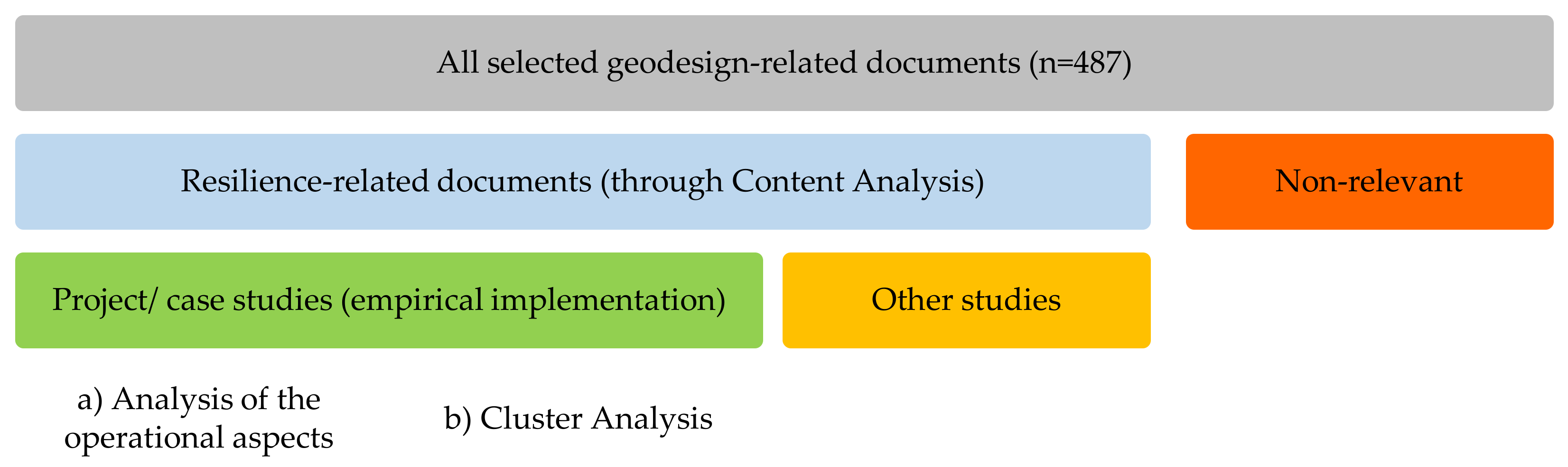
2.1. Selection of the Geodesign Documents

The selection of such documents followed a four-step process (Figure 1), which started with searching for scholarly publications indexed in the Scopus and Web of Science databases. The presence of “geodesign” or “geo-design” terms among title, abstract, or keywords (by authors) texts were searched using these two databases. The search parameters specified above were applied to obtain only those publications which have a significant focus on geodesign topics. Separate Scopus and Web of Science searches on 2 October 2020 yielded a total of 195 and 134 bibliographical records, respectively, that were downloaded and stored along with their standard publication details, such as abstract and keywords.
Both databases are comprehensive in listing peer-reviewed journal articles [31], with a limited number of book chapters, conference papers, and grey literature. To cover those, Crossref metadata was sought out for relevant books and book chapters. Furthermore, the Google Scholar database was checked, using the Publish or Perish tool [32] for collecting conference papers and grey literature. Applying the same search parameters on 2 October 2020, a total of 148 bibliographic records were retrieved from Crossref. Thorough a Google Scholar search on that date, a lump of 798 bibliographies were downloaded from the first 1000 accessible results that contained these searched term(s) anywhere in their texts. Missing abstract and keywords information of the collected Crossref and Google Scholar records were updated through general web-searches.
For the third step, both Crossref and Google Scholar records were filtered out using similar parameters applied to the Scopus search. Subsequently, these results were aggregated into a combined bibliographic data (n = 896). Screening for duplicate titles (n = 363) followed by relevance checks (at the fourth step) removed a total of 409 records from this combined data. These relevance checks excluded non-English publications, call-for-papers, and conference proceedings titles as well as the documents which used the “geodesign” term to denote names of material, product, firms, businesses, and digital technologies, which are not relevant to the study. The resultant 487 unique and relevant bibliographies and their linked documents were selected for review. Among those selected documents, a majority of n = 306, were journal articles followed by book chapters (n = 91), conference papers (n = 48), and grey literature which included reports and theses (n = 42). The preparation, storage, aggregation, and screening of the bibliographic data was performed with EndNote (v. X8) software.

2.2. Analysis Framework Development

The resilience planning work fundamentally requires identifying the spatial (“where”) and temporal (“when”) dimensions [33] for an empirical implementation. Determining the risks (what) involved and purpose (“why”) of pursuing resilience are also necessary in order to outline the strategic actions required for desired improvement [34]. Furthermore, in that process it is essential to recognise resilience of “whose” [5] or for “whom” [33] is to be improved, approach to the plan, i.e., “how” [12], and the stakeholders—“who” [5] are involved in the plan and decision-making processes. Hence, these seven questions, i.e., “what”, “why”, “whose”, “where”, “when”, “how”, and “who” ─ are crucial to resilience planning underscoring the concern, purpose, beneficiary, context, period, approach, and stakeholders, respectively, behind its application.
Among the seven resilience questions, “what”, “why”, and “whose” can be seen as the grounding questions on which empirical resilience implementation relies. The remaining four questions may help to explain the operational aspects of such an implementation. Sensing a deep importance of those questions in resilience planning, this study’s analysis framework heavily relied on the framing of these key questions. Here, a comprehensive list of “key resilience terms” was developed regarding the seven questions that were later put into perspective for analysing the contents of the selected geodesign studies (Figure 2).
Initially, this study examined 27 different city resilience definitions to obtain such “key resilience terms”. Additionally, the keywords cited in relevant scholarly publications were added to the list of terms accessed from a bibliographic database. In this case, the Scopus database was used, which offers flexibility to search by the keywords specified by authors. Although the Web of Science database includes similar advanced search options, Scopus has the most comprehensive number of journal and document coverage [35]. Here, all publications containing “city resilien*ce” OR “urban resilien*ce” among the keywords specified by author(s) were selected. A wildcard ‘*’ was applied in the search [36] to yield multiple resilience terms, including resilient, resiliency, and resilience. A total of 471 unique publications with 1456 keywords were found in Scopus on 2 October 2020, which were downloaded and stored. A word frequency query with stemmed words was run on those keywords in NVivo software (v.12) to map all commonly cited keywords. Words (exact or stemmed) with at least 0.5% weighted coverage of the total analysed texts were considered as commonly cited keywords. Finally, these commonly cited keywords were combined into the list of terms.

2.3. Content Analysis and Document Clustering

Using the list of terms developed, a content analysis [37] was performed on the key bibliographic texts of the selected geodesign documents. The texts under the title [38], abstract, and keywords of all selected 487 bibliographies were undertaken during the contents analysis. Appropriate content codes [37] were generated in NVivo by labelling and organising texts extracted from the developed contents that matched the identified “key resilience terms”. All documents analysed with either “resilience” citied or inclusive of any “what”, “why”, and “whose” of resilience (grounding questions) term(s) in their contents were categorised as resilience-related studies for detailed analysis (Figure 2). The operational questions: “where”, “when”, “how”, and “who” were explored by analysing the full texts of the resultant resilience-related studies. Here, particular attention was given to comprehend approaches to resilience planning adopted in the resilience-related projects/case studies detailing upon the technology tools (“how”) used and stakeholders (“who”) involved.
Furthering the content analysis, a cluster analysis was performed based on coding similarity to map common topics from the resilience-related case studies (Figure 2). NVivo’s cluster analysis module was applied here to evaluate the correlation among the content codes generated. The Pearson correlation coefficient was chosen during the cluster analysis as it had been successfully applied in similar studies [39]. Throughout this study, a descriptive review approach was followed, which is a systematic and transparent procedure to explore a research topic’s body of knowledge [40]. To present the findings about frequency, temporality, and clusters of the analysed documents, descriptive statistics [41] were provided. As the body of literature in this intersection of the fields of geodesign and resilience is growing, presumably additional relevant publications may have been indexed in those databases since this analysis was performed.

3. Results

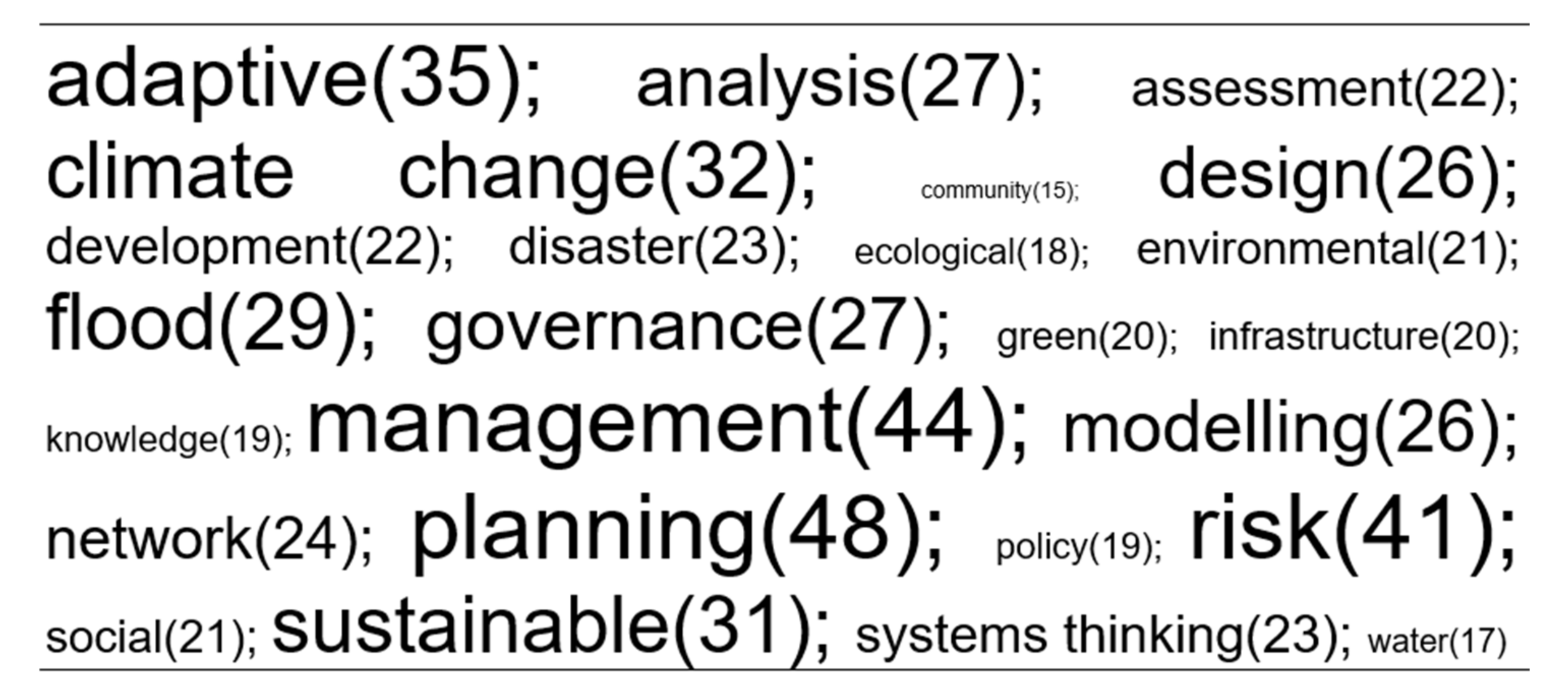
3.1. Key Resilience Terms

The Rockefeller Foundation and Arup [9] definition of city resilience conveys stresses and shocks as the central concerns (“what”) against which cities (“where”) should strengthen their capacity to function (“why”). This definition also includes survive and thrive as other purposes (“why”) of improving capacity to support people (“whose”) currently (“when”) living and working in cities. In addition, city or urban resilience has had several other popular definitions [31] in which the notion of disaster risk reduction is apparent [12]. Upon reviewing 25 city resilience definitions, Merrow et al. [31] have underscored “systems thinking”, “persistence”, “transition”, “disturbance”, “change”, “transformation”, “adaptability”, “temporality” (current, and future) as critical words in describing the important elements of city resilience thinking.
Furthermore, the following unique terms were found from the resilience definitions compiled by Merrow et al. [31], relating to the fundamental questions: “alteration” [42]; “sustainable and communities” [43]; “adjust” [44]; “build” (capacity), “face”, “governance”, and “uncertainty” [45]; “destruction” and “rebound” [46]; “tolerate”, “respond”, “reduce”, “counteract”, and “recover” [47]; “reorganise” [48]; “withstand” [49]; “practitioners”, and “innovation” [50]; “flood”, “damage”, “prevent”, and “maintain” [51]; “climate change”, “resist”, and “catastrophic” [16]; “disaster” and “town” [52]; “absorb” [53]; “avoid”, “hazard”, and “susceptibility” [54]; “asset” [55]; “calamities” [56]; “disruption” [57]; “population” and “endure” [58]; “social”, “economic”, “natural”, and “future-proof” [59]; “bounce-back” and “crisis” [60].
Through the keywords analysis of the city resilience-related scholarly articles (n = 471), a strong focus on improving sustainability and adaptive capacity was recognised for adaptative management or mitigation planning of climate change and flood (natural hazard) risk (Figure 3). Hence, climate change and nature-caused disasters had the most significant appearance as the “what” of resilience that were being pursued in the articles analysed. Improving the adaptive capacity was the most significant “why” of resilience that the analysed studies were aiming to address. These studies were involved with a large spectrum of city systems, including environment (natural and built), society, ecology, community, infrastructure, and water systems and their networks, as the “whose” of resilience pursued.
For operationalising (“how”) resilience actions, city governance appeared to be of great importance (Figure 3). Data analysis, assessment, and modelling works were integral to the resilience planning process found in the scholarly articles analysed. Other than the systems thinking approach, green or nature-based solutions to planning, and design thinking was discovered during the analysis. The word “development” was mainly identified as conjunctive to the “why” or “whose” terms, such as capacity development and infrastructure development.
Due to a profound connection, key disaster risk reduction terms such as risk reduction, emergency, exposure, and vulnerability [12] were also incorporated to the list of key resilience terms developed. By synthesising and placing all those terms under the seven fundamental resilience questions, a comprehensive list of the “key resilience terms” was developed (Figure 4). The list was later utilised for categorising and clustering the selected geodesign documents.

3.2. Content Analysis and Categorisation

The presence of the word “resilience”, or any other term under each of the grounding questions (Figure 4) was sought in the contents of all selected geodesign documents (n = 487). A total of 54 codes ("resilience” = 1, “what” = 23, “why” = 14, and “whose” = 16) were generated in line with those identified terms during content analysis. In addition to flood as a significant “what”, other natural hazards, e.g., storms, landslides, earthquakes, found in the analysing contents were coded separately and added to the categorisation process.
The resultant categorisation excluded nearly one-third (n = 157) of all selected documents from further consideration (Figure 5). Here, only a fraction (n = 24) of the total analysed documents were resilience focused, having “resilience” citied in their contents. Another 51 documents, excluding those (n = 9) citing “resilience”, had any of all “what”, “why”, and “whose” of resilience related terms in their contents analysed. Therefore, a total of 75 documents (around 15%) were revealed as resilience-related studies during this analysis and were subjected to a full text reading (see Supplementary Materials for a list of the selected documents). Importantly, more than three-quarters (n = 59) of those resilience-related studies showcased geodesign-based projects/case studies, including academic dissertations (n = 6). The remaining were generally theoretical frameworks/perspectives/reviews (n = 13), and editorial (n = 3) documents.
The temporality of all selected geodesign studies exhibited a recent declining trend (two-year moving average) after 2014. Yet, the total share of resilience-related studies (n = 75) among all studies (n = 487) has remained somewhat consistent since 2014 (Figure 6).

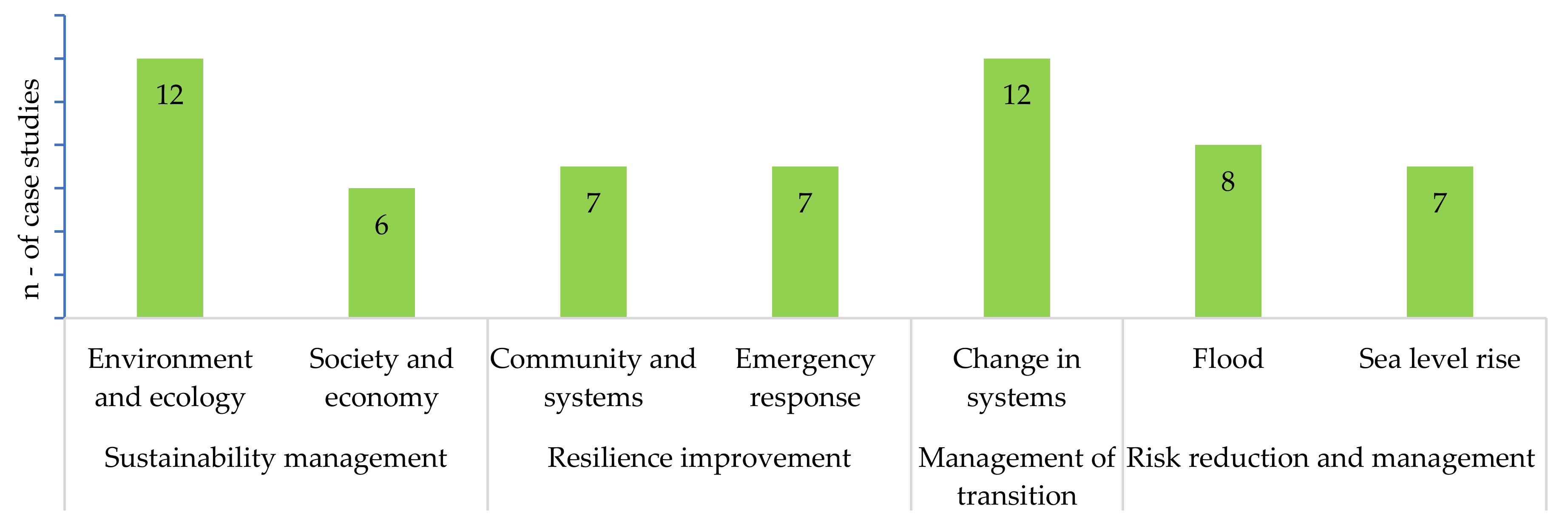
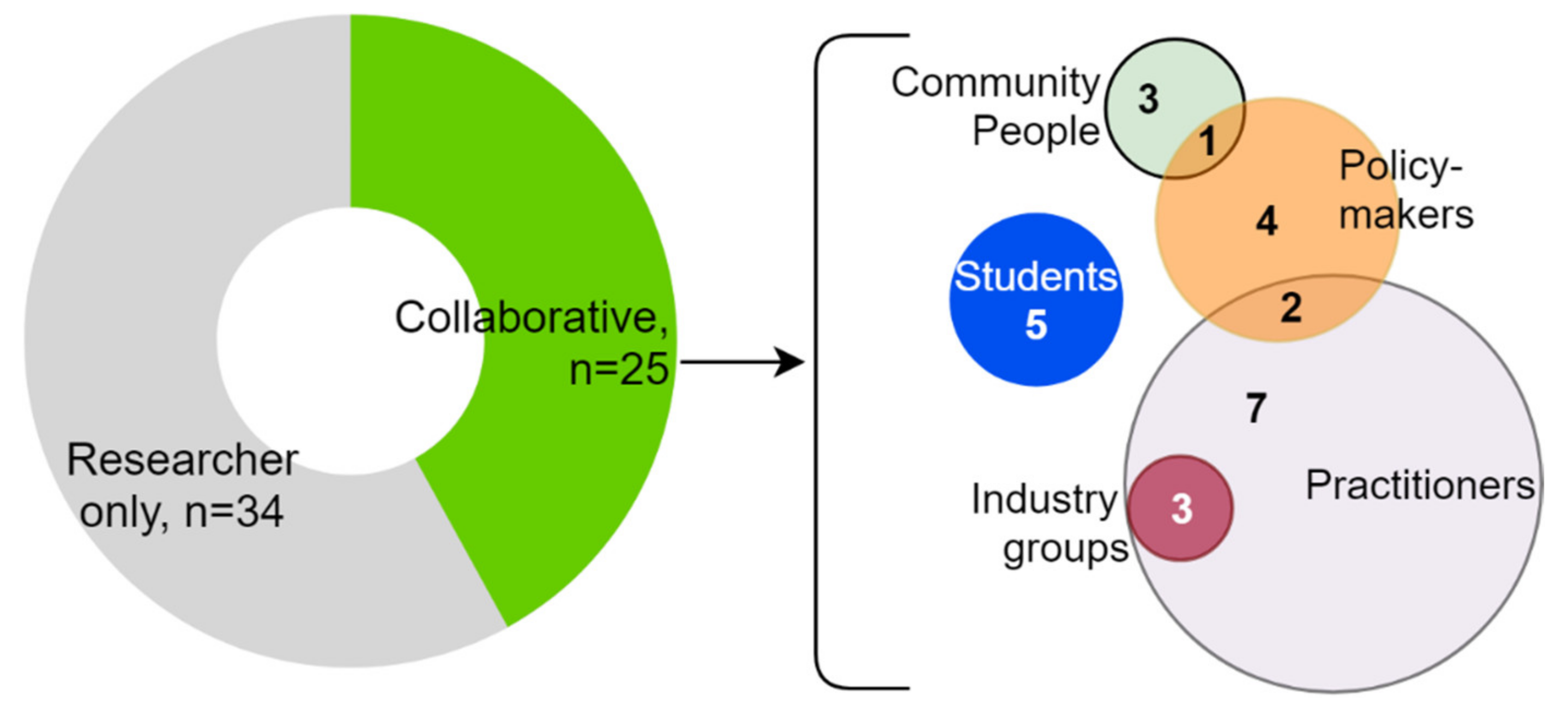
3.3. Analysis of the Geodesign Case Studies

The identified resilience-related case studies (n = 59, see Figure 5) form the basis for this ensuing analysis and interpretation, as this research aims to learn from their empirical applications. As all case studies were focused on future planning and design, the temporal dimension “when” was not explicitly analysed in this section. A majority of the case studies were undertaken in the United States (n = 20) followed by the Netherlands (n = 10), China (n = 7), Italy (n = 4), Australia (n = 3), Brazil (n = 3), Canada (n = 3), Ghana (n = 2), Spain (n = 2), and one in Bangladesh, Indonesia, New Zealand, Taiwan, and Vietnam. Therefore, in comparison to the rest of the world, the application of geodesign to resilience was clearly prominent in North American and European contexts.

3.3.1. Overview of the Resilience-Related Applications

In answering the first research question of this research, the content coding results were examined with a further cluster analysis of the analysed case studies (n = 59). The coding result revealed a major focus of such case studies on accounting (“what”), local systems’ change, global climate change, and impending disasters such as floods and the rise in sea level. Sustainability thinking was a distinguished purpose (“why”) behind resilience improvement works found in the analysed case studies. Overall, in such case studies, the resilience of (“whose”) the environment, community, local systems, nature, and society were commonly pursued.
These findings were further reflected in the clustering output. Seven distinct clusters were identified (Figure 7) across all resilience-related case studies. In general, resilience thinking was seen receiving great attention in the context of environmental and societal sustainability (n = 18). This could be due to geodesign’s ability to address complex socio-environmental systems in the planning process [61]. Another close topic relating to the socio-ecological system’s ongoing and anticipated changes was also practised (n = 12) popularly through geodesign. Additionally, according to Figure 3, the impact of climate change and its associated seaward hazards were prevalent resilience topics in the analysed case studies. In this regard, floods and the rise in sea level were two main resilience topics forming a strong disaster risk management cluster (n = 15) in the analysis outcome. Improving community and emergency system resilience was a relatively less prioritised aspect found among the analysed case studies.

3.3.2. Context of Resilience Implementation (“Where”)

The flooding- and the rise in sea level-focused case studies were commonly implemented on a city scale. However, case studies related to flooding and sea level rise, as well as those focused on improving resilience to current and anticipated future changes, were implemented in a variety of other regions and landscape systems. Watershed, floodplains, forests, agriculture land, parks, and university campuses were some notable landscapes where resilience planning considered a geodesign approach. Moreover, the resilience-related case studies were implemented in other contexts, including ecosystem management [62], emergency response planning [63], environmental issues (pollution, waste, and energy), social dimensions (behaviour, demography), and policy changes. The communities prone to disaster [64], vulnerable territories [65], and biodiversity habitat [66] were also covered in the case studies analysed.

3.3.3. Approach and Tools Used (“How”)

Steinitz’s geodesign framework [19] was adopted extensively (42%) among the analysed case studies. Several other studies applied their own procedural geodesign approaches, e.g., [15,67,68] to perform resilience-related works. Such procedural approaches essentially integrated geographic information and decision sciences and were completed through a single iteration, unlike Steinitz’s framework [19]. The design or planning method in all analysed case studies relied heavily on various data inputs including geographic, social, and environmental information. However, the data utilisation process in those case studies was notably different. For instance, a significant portion (n = 18) of the case studies adopted a collaborative design method. In that method, the design activities were supported by data and implemented via stakeholder workshops, e.g., [69].
Several other studies (n = 13) performed exploratory designs using planning support tools (e.g., CommunityViz) based on anticipated future changes to various systems such as urbanisation, and housing, e.g., [70]. Data-driven modelling and simulation tools such as SLEUTH [71] and Land Use Scanner [72] were implemented in several case studies (n = 10). Rule-based (n = 8) and optimisation (n = 4) models were also frequently applied to support such design activities. It is important to note that such data-driven models and optimisation algorithms, running in a computer environment, are integral to the computational approach [73].
Generally, two to four alternative designs or scenario plans were developed in the analysed case studies (n = 59). Necessary spatial data preparation (e.g., vulnerability maps) and analysis inputs (e.g., suitability assessment) to geodesign have been underpinned through a strong GIS approach in all analysed case studies. Esri’s software tools in such cases were utilised most extensively (n = 30). The application of other GIS tools such as QGIS (n = 2) and TerrSet (n = 2) software packages were also found in those studies. Many case studies (n = 8) utilised three-dimensional planning support tools, such as CityEngine, 3Di Model, and Flood Lizard while planning to improve resilience. Furthermore, other planning support tools, e.g., GeodesignHub (n = 5) and CommunityViz (n = 4) were seen utilised in such resilience-related geodesign applications.

3.3.4. Stakeholders Involved (“Who”)

Being a collaborative approach, geodesign requires engaging stakeholders in its different activities together with a multi-disciplinary geodesign team. Typically, a geodesign team was comprised of 2–6 researchers in the case studies analysed. Stakeholder collaboration, either at design and decision-making (n = 18), or only at decision-making (n = 7) activities, was found in around 42% (n = 25) of those case studies. Such case studies commonly (n = 13) organised one workshop throughout their implementation. Although, arranging two or more workshops (n = 12) was also quite common. The total duration of such workshops varied between five hours [74] and up to 3 days [75]. Total number of the stakeholders engaged in the analysed resilience case studies ranged between 8–25 persons.
Different stakeholders, apart from researchers, were engaged in those collaborative case studies (Figure 8) to gain input and feedback from them, e.g., [15,75]. Such stakeholders commonly included community people (n = 4), industry groups (e.g., farmers, n = 3), practitioners (e.g., planners, and designers, n = 12), local authorities and policymakers (n = 7). A number of collaborative case studies (n = 5) involved only students (roleplaying of local stakeholders) to demonstrate a geodesign approach and its replicability [74].
In contrast, nearly 58% (n = 34) of the analysed case studies did not engage stakeholders at any stage in their geodesign activities. Instead, most often, the researchers (geodesign team) ran optimisation methods or suitability analyses of the alternative plans to find the best possible solution to the studied problem through multi-criteria evaluation, e.g., [65,68]. The above-mentioned planning support tools, including data-driven models, were pertinent to non-collaborative, researcher-only studies.

4. Discussions

During this review study, several new planning and design concepts were discovered, which intersected with geodesign principles [27] throughout the implementation of resilience-related case studies. For instance, the “HydroDesign” concept [76] focused on designing water systems to mitigate flood impact and improve water resource’s sustainability. Similarly, using geodesign and data-driven models, a “Smart Design” concept [67] was undertaken with the primary goal to improve overall performance of the urban built-environment. The “Informed Urbanisation” concept [77], underscoring a way forward to deal with the challenge brought about by rapid urbanisation, is another example that embeds digital data and technology tools through an augmented geodesign approach. To deal with urban energy needs, the “Living Lab” approach [78] has been applied to support the co-creation of sustainable solutions and promote a circular economy [79]. Additionally, the Meta-design [64] that empowers communities in decision-making, and Performance-based Design [80], using metrices to evaluate energy resilience, were other relevant concepts recognised.
Improving the sustainability (“why”) of various city systems, such as infrastructure, and housing, was the main purpose of practising resilience among the analysed case studies. Notable concerns (“what”) behind such resilience thinking was related to flooding, climate change, and risks related to the rise in sea levels. Advanced techniques to climate change and flood risk modelling [81] were seen to contribute to those works, supplying more data-driven inputs. It is worth noting that both sustainability thinking and flood risk were also prominent in the analysed scholarly resilience literature (see Section 3.1). This could be interpreted as a reassertion of global resilience practices. Although, community resilience, a priority topic, was found to be underrepresented in the analysed case studies (see Figure 7).
Stakeholder engagement was seen considerably low in resilience-related geodesign works. A similar finding was previously reported by Tulloch [82], who, in assessing 28 different projects, found that 11 were non-collaborative in nature. This study also found a dearth of community engaging practices among the analysed cases, which is crucial for resilience planning. Furthermore, there were scant real collaborative planning examples, e.g., [83] among the evaluated cases that required an interfacing of both community people and policymakers in the planning process [84]. Interestingly, industry groups were found collaborating with the practitioners at each case, but none with the policymakers or community people. Falco [17] further has highlighted the issue of a notable absence of community participation in resilience planning practices.
Given that geodesign approaches are aimed to support collaborative design and planning exercises, the above finding is concerning. Further research is therefore required to understand the barriers of collaboration between key actor groups in the resilience planning process. In the context of Planning Support Systems, Russo et al. [85] and Vonk et al. [86] have undertaken studies into the usability and adoption of such systems in planning practice. However, such studies have not yet been carried out in the context of geodesign and supporting digital tools and underlying urban governance frameworks.
Overall, the analysed case studies were seen heavily relying on spatial data and GIS technology as a common toolkit for geodesign. Creating alternative scenario plans in regard to anticipated future changes is an essential step in geodesign. Among the analysed cases, a total of 18 studies engaged stakeholders during such scenario planning. The remaining 41 studies relied on computational approaches such as modelling and simulation for that purpose. Therefore, two different key approaches to scenario planning within geodesign were clear: (1) collaborative—engaging real world or role-playing stakeholders, and (2) computational—essentially computer-driven but not collaborative, in the sense of allowing stakeholders to plan or design.
Improving resilience through the reduction and management of disaster risks were typically sought in the analysed case studies. Although, the aim of resilience planning should not be just to lower or manage risks, rather it should be to coordinate efforts to promote sustainable development [49], such as improving adaptive and recovery capacities to future uncertainties. Additionally, “risk adaptation” is a more rational approach than “risk mitigation” for improving resilience [7]. Furthering this, improving social and institutional capacities against future uncertainties is also crucial for resilient cities. Hence, considerations of a comprehensive resilience framework, e.g., [9] combining physical aspects of cities with human behaviour in response to various disruptions, can add value to the overall planning practices.
In light of the above discussion, we think that resilience planning practices based on the geodesign approach can be improved further with additional data-driven inputs. We assert the Steinitz’s [19] framework as a suitable conceptual artefact for mapping such improvements, especially during the last three intervention steps (Figure 9). Starting with the Change Models step, an integration of collaborative and computational approaches could be promising, since both inputs are critical to the resilience planning process. This integration has the potential to offer a unique opportunity to validate planning and policy proposals through the lens of both stakeholder’s insights and data-driven results. This way, a stakeholder’s participation in the planning and decision processes can also be ensured.
Following the creation of scenario plans, it is important to analyse their performance in the context of a future city, since a performance-based approach holds practical promise to resilience planning [9]. This performance analysis against resilience planning goals, such as avoiding new urbanisation in disaster-prone areas, can be integrated within the framework’s Impact Models step. Here, a rapid analytic tool can be applied to speed up the analysis process, given that the framework can underpin such technology tools efficiently. The obtained performance result, in addition to the knowledge-based appraisal of the stakeholders, can further be incorporated during decision-making at the last step (Decision Models). Nonetheless, stakeholders would be required to accept the plan’s performance metrics when formulating planning strategies and policies. These suggested improvements to the steps within the framework could be promising for evidence-based resilience planning, as they are underscored by more data-driven inputs and digital tools, such as planning support systems reported in the literature [87,88], than what has been applied so far.

5. Conclusions

There is growing interest to address resilience in city planning discourse [31], as those areas are the centres of economic activity on a rapidly urbanising planet [1]. To grow sustainably against the potential consequences of ongoing climate change, such as the rise in sea levels, floods, and bushfires, a resilience planning methodology that enables and ensures the involvement of local communities, policymakers, and other stakeholders is needed. In this regard, geodesign or related methods offer opportunities to enhance city resilience planning. However, a low number (n = 75) of resilience-related studies were revealed among this study’s analysed documents (n = 487).
Based on the above depicted facts we conclude that the geodesign approach has untapped potential to support real collaborative resilience planning that has not been practised widely. Contrarily, in the last decade, the total number of geodesign-related scholarly and grey literature documents published each year exhibited a declining trend. In this regard, we speculate that the ongoing rise in computational approaches, such as data-driven models and artificial intelligence (AI) technologies, are offsetting the adoption of collaborative approaches that are often time intensive and require the stakeholders to be co-located. Yet, the resilience-related studies published in recent years represented a consistent portion of all documents reviewed.
Another critical outcome from this review study is related to the paucity of collaborative case studies found among the analysed documents. Working with practitioners, such as planners, was the most common form of collaboration. Moreover, a handful of such studies were experimented with students only. Geodesign, therefore, may be transitioning as a resilience planning approach with continual research involving subject domain and academic experts. This approach needs further experimentation and evidence on how it can support human centred design, through the interfacing of the people of place and policymakers, while making decisions regarding resilience planning proposals. The emergent Smart Urban Governance thinking model [89], combining stakeholder and technology (computer) driven approaches to manage a socio-spatial context, might also offer some opportunities to increase stakeholder participation in resilience decision-making.
This research provides a comprehensive review and systematic analysis of geodesign-based resilience planning cases. Learning from contemporary practices confers that resilience planning processes undertaking a geodesign approach can be improved with support from more data-driven inputs. The conceptual pathway of such an improvement provided in this paper opens up a number of future research agendas. These include research on the utility of integrating data-driven modelling and simulation within a collaborative scenario planning process, the usability of digital tools such as planning support systems within a collaborative geodesign framework, and the value of the plan’s performance evaluation during decision-making.

Supplementary Materials

The following supporting information can be downloaded at: https://www.mdpi.com/article/10.3390/su14020938/s1, A bibliographic list of the 75 documents selected for this review study.

Author Contributions

Concept and methodology, R.D. and C.P.; original draft preparation, R.D.; review and editing, C.P. and S.Z.L. All authors have read and agreed to the published version of the manuscript.

Funding

This research received no external funding.

Acknowledgments

This research is developed throughout a PhD work, which has been supported by the UNSW’s University International Postgraduate Award (UIPA) Scholarship.

Conflicts of Interest

The authors declare no conflict of interest.

References

  1. United Nations. World Urbanization Prospects: The 2014 Revision, Highlights (ST/ESA/SER.A/352); Department of Economic and Social Affairs, Population Division: New York, NY, USA, 2014. [Google Scholar]
  2. Hanewinkel, M.; Arias, J.P.; Bronfman, N.C.; Cisternas, P.C.; Repetto, P.B. Hazard proximity and risk perception of tsunamis in coastal cities: Are people able to identify their risk? PLoS ONE 2017, 12, e0186455. [Google Scholar] [CrossRef] [Green Version]
  3. Jabareen, Y. Planning the resilient city: Concepts and strategies for coping with climate change and environmental risk. Cities 2013, 31, 220–229. [Google Scholar] [CrossRef]
  4. Peyroux, E. Discourse of Urban Resilience and ‘Inclusive Development’ in the Johannesburg Growth and Development Strategy 2040. Eur. J. Dev. Res. 2015, 27, 560–573. [Google Scholar] [CrossRef]
  5. Vale, L.J. The politics of resilient cities: Whose resilience and whose city? Build. Res. Inf. 2014, 42, 191–201. [Google Scholar] [CrossRef]
  6. Ahern, J. Urban landscape sustainability and resilience: The promise and challenges of integrating ecology with urban planning and design. Landsc. Ecol. 2013, 28, 1203–1212. [Google Scholar] [CrossRef]
  7. Pizzo, B. Problematizing resilience: Implications for planning theory and practice. Cities 2015, 43, 133–140. [Google Scholar] [CrossRef]
  8. Schipper, L.; Pelling, M. Disaster risk, climate change and international development: Scope for, and challenges to, integration. Disasters 2006, 30, 19–38. [Google Scholar] [CrossRef]
  9. Rockefeller Foundation; Arup. City Resilience Framework: City Resilience Index; Arup International Development: London, UK, 2014. [Google Scholar]
  10. Sanderson, D. Urban humanitarian response. In Good Practice Review 12; Overseas Development Institute: London, UK, 2019. [Google Scholar]
  11. Davoudi, S.; Shaw, K.; Haider, L.J.; Quinlan, A.E.; Peterson, G.D.; Wilkinson, C.; Fünfgeld, H.; McEvoy, D.; Porter, L.; Davoudi, S. Resilience: A Bridging Concept or a Dead End? “Reframing” Resilience: Challenges for Planning Theory and Practice Interacting Traps: Resilience Assessment of a Pasture Management System in Northern Afghanistan Urban Resilience: What Does it Mean in Planning Practice? Resilience as a Useful Concept for Climate Change Adaptation? The Politics of Resilience for Planning: A Cautionary Note. Plan Theory Pract. 2012, 13, 299–333. [Google Scholar] [CrossRef] [Green Version]
  12. Twigg, J. Disaster Risk Reduction. In Good Practice Review 9; Overseas Development Institute: London, UK, 2015. [Google Scholar]
  13. Rittel, H.W.J.; Webber, M.M. Dilemmas in a general theory of planning. Policy Sci. 1973, 4, 155–169. [Google Scholar] [CrossRef]
  14. EPICURO. Best Practices Analysis; European University Cyprus: Engomi, Cyprus, 2018; pp. 1–166. [Google Scholar]
  15. Wu, C.L.; Chiang, Y.C. A geodesign framework procedure for developing flood resilient city. Habitat Int. 2018, 75, 78–89. [Google Scholar] [CrossRef]
  16. Brown, A.; Dayal, A.; Rumbaitis Del Rio, C. From practice to theory: Emerging lessons from Asia for building urban climate change resilience. Environ. Urban. 2012, 24, 531–556. [Google Scholar] [CrossRef] [Green Version]
  17. Falco, G.J. City Resilience through Data Analytics: A Human-centric Approach. Procedia Eng. 2015, 118, 1008–1014. [Google Scholar] [CrossRef] [Green Version]
  18. Raco, M.; Street, E. Resilience planning, economic change and the politics of post-recession development in London and Hong Kong. Urban Stud. 2012, 49, 1065–1087. [Google Scholar] [CrossRef]
  19. Steinitz, C. A Framework for Geodesign: Changing Geography by Design, 1st ed.; ESRI Press: Redlands, CA, USA, 2012. [Google Scholar]
  20. Batty, M. Defining geodesign (=GIS+design?). Environ. Plann. B Plann. Des. 2013, 40, 1–2. [Google Scholar] [CrossRef]
  21. Gu, Y.; Deal, B.; Larsen, L. Geodesign processes and ecological systems thinking in a coupled human-environment context: An integrated framework for landscape architecture. Sustainability 2018, 10, 3306. [Google Scholar] [CrossRef] [Green Version]
  22. Steiner, F.R.; Shearer, A.W. Geodesign-Changing the world, changing design. Landsc. Urban Plan. 2016, 156, 1–4. [Google Scholar] [CrossRef]
  23. Pettit, C.J.; Hawken, S.; Ticzon, C.; Leao, S.Z.; Afrooz, A.E.; Lieske, S.N.; Canfield, T.; Ballal, H.; Steinitz, C. Breaking down the silos through geodesign–Envisioning Sydney’s urban future. Environ. Plann. 2019, 46, 1387–1404. [Google Scholar] [CrossRef]
  24. Singleton, A.D.; Spielman, S.; Folch, D. Urban Analytics; SAGE Publications Ltd.: London, UK, 2017. [Google Scholar]
  25. Marcus, F. (Ed.) Handbook of Research on Urban Informatics: The Practice and Promise of the Real-Time City; IGI Global: Hershey, PA, USA, 2008; pp. 1–506. [Google Scholar]
  26. Nyerges, T.; Ballal, H.; Steinitz, C.; Canfield, T.; Roderick, M.; Ritzman, J.; Thanatemaneerat, W. Geodesign dynamics for sustainable urban watershed development. Sustain. Cities Soc. 2016, 25, 13–24. [Google Scholar] [CrossRef] [Green Version]
  27. Gu, Y.; Deal, B.; Orland, B.; Campagna, M. Evaluating practical implementation of geodesign and its impacts on resilience. J. Digit. Landsc. Archit. 2020, 2020, 467–475. [Google Scholar] [CrossRef]
  28. Newman, G.; Malecha, M.; Yu, S.; Qiao, Z.; Horney, J.A.; Lee, J.; Kim, Y.J.; Lee, R.J.; Berke, P. Integrating a resilience scorecard and landscape performance tools into a Geodesign process. Landsc. Res. 2020, 45, 63–80. [Google Scholar] [CrossRef]
  29. Steinitz, C. On change and geodesign. Landsc. Urban Plann. 2016, 156, 23–25. [Google Scholar] [CrossRef]
  30. Eikelboom, T.; Janssen, R. Collaborative use of geodesign tools to support decision-making on adaptation to climate change. Mitig. Adapt. Strateg. Glob. Change 2017, 22, 247–266. [Google Scholar] [CrossRef] [Green Version]
  31. Meerow, S.; Newell, J.P.; Stults, M. Defining urban resilience: A review. Landsc. Urban Plann. 2016, 147, 38–49. [Google Scholar] [CrossRef]
  32. Harzing, A.W. Publish or Perish. Available online: https://harzing.com/resources/publish-or-perish (accessed on 15 April 2020).
  33. Meerow, S.; Newell, J.P. Urban resilience for whom, what, when, where, and why? Urban Geogr. 2016, 40, 309–329. [Google Scholar] [CrossRef]
  34. Sanchez, A.X.; van der Heijden, J.; Osmond, P. The city politics of an urban age: Urban resilience conceptualisations and policies. Palgrave Commun. 2018, 4. [Google Scholar] [CrossRef]
  35. Chadegani, A.A.; Salehi, H.; Yunus, M.; Farhadi, H.; Fooladi, M.; Farhadi, M.; Ale Ebrahim, N. A comparison between two main academic literature collections: Web of Science and Scopus databases. Asian Soc. Sci. 2013, 9, 18–26. [Google Scholar] [CrossRef] [Green Version]
  36. Wahyudi, A.; Liu, Y. Cellular Automata for Urban Growth Modelling: A Review on Factors defining Transition Rules. Int. Rev. Spat. Plan. Sustain. Dev. 2016, 4, 60–75. [Google Scholar] [CrossRef] [Green Version]
  37. Erlingsson, C.; Brysiewicz, P. A hands-on guide to doing content analysis. Afr. J. Emerg. Med. 2017, 7, 93–99. [Google Scholar] [CrossRef]
  38. Milojević, S.; Sugimoto, C.R.; Yan, E.; Ding, Y. The cognitive structure of Library and Information Science: Analysis of article title words. J. Am. Soc. Inf. Sci. Technol. 2011, 62, 1933–1953. [Google Scholar] [CrossRef]
  39. Huang, A. Similarity measures for text document clustering. In Proceedings of the Sixth New Zealand Computer Science Research Student Conference (NZCSRSC2008), Christchurch, New Zealand, 14–18 April 2008; pp. 9–56. [Google Scholar]
  40. Paré, G.; Kitsiou, S. Methods for Literature Reviews. In Handbook of eHealth Evaluation: An Evidence-Based Approach; Lau, F., Kuziemsky, C., Eds.; University of Victoria: Victoria, BC, Canada, 2016; pp. 157–179. [Google Scholar]
  41. Seuring, S.; Gold, S. Conducting content-analysis based literature reviews in supply chain management. Supply Chain. Manag. Int. J. 2012, 17, 544–555. [Google Scholar] [CrossRef]
  42. Alberti, M.; Marzluff, J.M.; Shulenberger, E.; Bradley, G.; Ryan, C.; Zumbrunnen, C. Integrating Humans into Ecology: Opportunities and Challenges for Studying Urban Ecosystems. BioScience 2003, 53, 1169–1179. [Google Scholar] [CrossRef] [Green Version]
  43. Godschalk, D.R. Urban Hazard Mitigation: Creating Resilient Cities. Nat. Hazards Rev. 2003, 4, 136–143. [Google Scholar] [CrossRef]
  44. Pickett, S.T.A.; Cadenasso, M.L.; Grove, J.M. Resilient cities: Meaning, models, and metaphor for integrating the ecological, socio-economic, and planning realms. Landsc. Urban Plann. 2004, 69, 369–384. [Google Scholar] [CrossRef]
  45. Ernstson, H.; van der Leeuw, S.E.; Redman, C.L.; Meffert, D.J.; Davis, G.; Alfsen, C.; Elmqvist, T. Urban Transitions: On Urban Resilience and Human-Dominated Ecosystems. AMBIO 2010, 39, 531–545. [Google Scholar] [CrossRef] [Green Version]
  46. Campanella, T.J. Urban Resilience and the Recovery of New Orleans. J. Am. Plan. Assoc. 2006, 72, 141–146. [Google Scholar] [CrossRef]
  47. Wardekker, J.A.; de Jong, A.; Knoop, J.M.; van der Sluijs, J.P. Operationalising a resilience approach to adapting an urban delta to uncertain climate changes. Technol. Forecast. Soc. Change 2010, 77, 987–998. [Google Scholar] [CrossRef] [Green Version]
  48. Ahern, J. From fail-safe to safe-to-fail: Sustainability and resilience in the new urban world. Landsc. Urban Plann. 2011, 100, 341–343. [Google Scholar] [CrossRef] [Green Version]
  49. Leichenko, R. Climate change and urban resilience. Curr. Opin. Environ. Sustain. 2011, 3, 164–168. [Google Scholar] [CrossRef]
  50. Tyler, S.; Moench, M. A framework for urban climate resilience. Clim. Dev. 2012, 4, 311–326. [Google Scholar] [CrossRef]
  51. Liao, K.H. A Theory on Urban Resilience to Floods—A Basis for Alternative Planning Practices. Ecol. Soc. 2012, 17, 48. [Google Scholar] [CrossRef]
  52. Lamond, J.E.; Proverbs, D.G. Resilience to flooding: Lessons from international comparison. Proc. Inst. Civ. Eng. Urban Des. Plan. 2009, 162, 63–70. [Google Scholar] [CrossRef]
  53. Lhomme, S.; Serre, D.; Diab, Y.; Laganier, R. Urban technical networks resilience assessment. In Resilience and Urban Risk Management; Serre, D., Barroca, B., Laganier, R., Eds.; CRC Press: London, UK, 2012. [Google Scholar]
  54. Wamsler, C.; Brink, E.; Rivera, C. Planning for climate change in urban areas: From theory to practice. J. Clean. Prod. 2013, 50, 68–81. [Google Scholar] [CrossRef] [Green Version]
  55. Brugmann, J. Financing the resilient city. Environ. Urban. 2012, 24, 215–232. [Google Scholar] [CrossRef]
  56. Hamilton, W.A.H. Resilience and the city: The water sector. Proc. Inst. Civ. Eng. Urban Des. Plan. 2009, 162, 109–121. [Google Scholar] [CrossRef]
  57. Coaffee, J. Towards Next-Generation Urban Resilience in Planning Practice: From Securitization to Integrated Place Making. Plan. Pract. Res. 2013, 28, 323–339. [Google Scholar] [CrossRef]
  58. Romero-Lankao, P.; Gnatz, D.M. Exploring urban transformations in Latin America. Curr. Opin. Environ. Sustain. 2013, 5, 358–367. [Google Scholar] [CrossRef]
  59. Thornbush, M.; Golubchikov, O.; Bouzarovski, S. Sustainable cities targeted by combined mitigation–adaptation efforts for future-proofing. Sustain. Cities Soc. 2013, 9, 1–9. [Google Scholar] [CrossRef]
  60. Wagner, I.; Breil, P. The role of ecohydrology in creating more resilient cities. Ecohydrol. Hydrobiol. 2013, 13, 113–134. [Google Scholar] [CrossRef]
  61. Deal, B.; Petri, A.; Pan, H.; Goldenberg, R.; Kalantari, Z.; Cvetkovic, V. Socio-Environmental Resilience and Complex Urban Systems Modeling. In Proceedings of the The EGU General Assembly Conference, Vienna, Austria, 1 April 2017; p. 18478. [Google Scholar]
  62. Nhan, N.H.; Haruyama, S. The visible impacts of human activities constructing hydropower dam on Vietnamese Mekong Delta and conceptual solutions for responses. Abstr. Int. Cartogr. Assoc. 2019, 1, 270. [Google Scholar] [CrossRef] [Green Version]
  63. Fraley, G.W. Including Natural Hazard Risk Analysis in an Optimization Model for Evacuation Planning: A Spatial Multi-Objective Memetic Algorithm; 2011. Available online: www.tortenmeer.de/images/All-Papers/MP-2010/Grant.pdf (accessed on 30 June 2020).
  64. Su, P.H. A Conceptual Framework of Communication System of Design for Empowering Post-disaster Communities. New Trends Syst. Sci. Eng. 2015, 276, 241–249. [Google Scholar] [CrossRef]
  65. Caperna, A.; Tracada, E.; Minervino, G.; Alatalo, E.; Cerreta, M. Spatial and economic smart strategies for the 21st-century metropolitan city of Naples. In Advances in 21st Century Human Settlements; Springer: Singapore, 2019; pp. 665–755. [Google Scholar] [CrossRef]
  66. Ribas, R.P.; Gontijo, B.M.; Moura, A.C.M. Geodesign for landscape connectivity planning. In Cartography-Maps Connecting the World; Springer: Cham, Switzerland, 2015; pp. 333–346. [Google Scholar] [CrossRef]
  67. Quan, S.J. Smart design for sustainable neighborhood development. In Proceedings of the 10th International Conference on Applied Energy, ICAE 2018, Hong Kong, China, 22–25 August 2018; pp. 6515–6520. [Google Scholar]
  68. Chen, S.; Lee, V. The Spatial Planning of Australia’s Energy Land-scape: An Assessment of Solar, Wind and Biomass Potential at the National Level. J. Digit. Landsc. Archit. 2016, 1, 169–178. [Google Scholar]
  69. Kazak, J.K.; Castro, D.G.; Swiader, M.; Szewranski, S. Decision Support System in Public Transport Planning for Promoting Urban Adaptation to Climate Change. In Proceedings of the 3rd World Multidisciplinary Civil Engineering, Architecture, Urban Planning Symposium, WMCAUS 2018, Prague, Czech Republic, 18–22 June 2018. [Google Scholar]
  70. Zuidema, S.; Cronan, D.; Trammell, E.J.; Lammers, R.B. Plausible 21st century water management through stakeholder-driven modeling of a water-stressed, agricultural socio-economic system in the American West. In Proceedings of the AGU Fall Meeting Abstracts, San Francisco, CA, USA, 9–13 December 2019. [Google Scholar]
  71. Akyol, M.; Tuncay, H.E. A Portrayal of Uncertainty: Revealing Problems and Opportunities of Landscape Change via Sleuth Cellular Automata Model. J. Digit. Landsc. Archit. 2016, 1, 150–160. [Google Scholar] [CrossRef]
  72. Koomen, E.; Rijken, B.C. Recent Applications of a Land-use Change Model in Support of Sustainable Urban Development. In Geodesign by Integrating Design and Geospatial Sciences; GeoJournal Library; Springer International Publishing: Berlin/Heidelberg, Germany, 2014; pp. 87–102. [Google Scholar]
  73. Gahegan, M. Fourth paradigm GIScience? Prospects for automated discovery and explanation from data. Int. J. Geogr. Inf. Sci. 2020, 34, 1–21. [Google Scholar] [CrossRef] [Green Version]
  74. Cocco, C.; Appleyard, B. A geodesign collaboration for the Mission Valley project, San Diego, USA. In Planning, Nature and Ecosystem Services; Gargiulo, C., Zoppi, C., Eds.; FedOAPress: Naples, Italy, 2019; pp. 399–409. [Google Scholar]
  75. Rivero, R.; Smith, A.L.; Ballal, H.; Steinitz, C.; Orland, B.; McClenning, L.; Calabria, J.; Perkl, R.; Key, H. Experiences in geodesign in Georgia, USA. Disegnarecon 2018, 11, 14.1–14.14. [Google Scholar]
  76. Maidment, D.R. HydroDesign and the Digital Campus. 2013. Available online: http://caee.utexas.edu/prof/maidment/CE365KSpr14/Docs/HydroDesign.pdf (accessed on 24 April 2020).
  77. Pettit, C.; Wentz, E.; Randolph, B.; Sanderson, D. Tackling the challenge of growing cities: An informed urbanisation approach. In Open Cities|Open Data; Hawken, S., Han, H., Pettit, C., Eds.; Palgrave Macmillan: Singapore, 2020; pp. 197–219. [Google Scholar]
  78. Cerreta, M.; De Toro, P.; Inglese, P.; Iodice, S. Operationalizing Circular Economy: Adaptive Assessments for Wastescape Regeneration. In Proceedings of the International Conference for the 75th Anniversary of DTI, Pécs, Hungary, 19–20 April 2018. [Google Scholar]
  79. Remøy, H.; Wandl, A.; Ceric, D.; van Timmeren, A. Facilitating circular economy in urban planning. Urban Plan. 2019, 4, 1–4. [Google Scholar] [CrossRef]
  80. Yang, P.P.-J. Energy Resilient Urban Planning. In Geodesign by Integrating Design and Geospatial Sciences; GeoJournal Library; Springer International Publishing: Berlin/Heidelberg, Germany, 2014; pp. 43–54. [Google Scholar]
  81. Yamazaki, D.; Watanabe, S.; Hirabayashi, Y. Global Flood Risk Modeling and Projections of Climate Change Impacts. In Global Flood Hazard: Applications in Modeling, Mapping, and Forecasting; Geophysical Monograph Series; Schumann, G.J.P., Bates, P.D., Apel, H., Aronica, G.T., Eds.; John Wiley & Sons, Inc: Washington, DC, USA, 2018; pp. 185–203. [Google Scholar]
  82. Tulloch, D. Toward a working taxonomy of geodesign practice. Trans. GIS 2017, 21, 635–646. [Google Scholar] [CrossRef]
  83. Peddemors, Y.; Willemse, B. Case study: Flood impact reduction. In Proceedings of the 9th International Conference on Computer Simulation in Risk Analysis and Hazard Mitigation, RISK 2014, New Forerst, UK, 4 June 2014; pp. 441–449. [Google Scholar]
  84. Healey, P. Collaborative Planning in Perspective. Plan. Theory 2003, 2, 101–123. [Google Scholar] [CrossRef] [Green Version]
  85. Russo, P.; Lanzilotti, R.; Costabile, M.F.; Pettit, C.J. Towards satisfying practitioners in using Planning Support Systems. Comput. Environ. Urban Syst. 2018, 67, 9–20. [Google Scholar] [CrossRef]
  86. Vonk, G.; Geertman, S.; Schot, P. Bottlenecks Blocking Widespread Usage of Planning Support Systems. Environ. Plan. Econ. Space 2005, 37, 909–924. [Google Scholar] [CrossRef] [Green Version]
  87. Gu, Y.; Deal, B. Geodesign, resilience and planning support systems: The integration of process and technology. In Handbook of Planning Support Science; Geertman, S., Stillwell, J., Eds.; Edward Elgar Publishing: Cheltenham, UK, 2020; pp. 110–131. [Google Scholar]
  88. Yang, P.P.J.; Chang, S.; Saha, N.; Chen, H.W. Data-driven planning support system for a campus design. Env. Plan B Urban 2020, 47, 1474–1489. [Google Scholar] [CrossRef]
  89. Jiang, H.; Geertman, S.; Witte, P. Smart urban governance: An alternative to technocratic “smartness”. GeoJournal 2020. [Google Scholar] [CrossRef] [PubMed]
Figure 1. Selection steps of the geodesign-related documents (n = number of outcome).
Sustainability 14 00938 g001
Figure 2. Key review and analysis steps followed in this study.
Sustainability 14 00938 g002
Figure 3. Word cloud of common citied keywords found in the analysed scholarly articles (n = 471), excluding the words “city”, “urban”, and “resilience”, which were included in the search criteria.
Sustainability 14 00938 g003
Figure 4. The identified ”key resilience terms” grouped by the resilience questions that were extracted from popular city resilience definitions and scholarly articles.
Sustainability 14 00938 g004
Figure 5. Categorisation of the selected geodesign documents (n = 487) through content analysis.
Sustainability 14 00938 g005
Figure 6. Frequency and temporality of the resilience-related studies (n = 75) among all analysed geodesign documents (n = 487). 2020* values account only those accessible by the study’s search dates.
Sustainability 14 00938 g006
Figure 7. Generalised clusters of the resilience-related case studies (n = 59) that demonstrate the focus of different empirical implementations.
Sustainability 14 00938 g007
Figure 8. Composite overview of stakeholders’ involvement in the analysed case studies (n = 59). A breakdown of the collaborative case studies by the involved stakeholders is shown on the right.
Sustainability 14 00938 g008
Figure 9. A way forward to improve resilience planning practice within the geodesign framework.
Sustainability 14 00938 g009
Publisher’s Note: MDPI stays neutral with regard to jurisdictional claims in published maps and institutional affiliations.

