Article

Study on Stability and Ecological Restoration of Soil-Covered Rocky Slope of an Abandoned Mine on an Island in Rainy Regions

1
Second Institute of Oceanography, Ministry of Natural Resources, Hangzhou 310012, China
2
Key Laboratory for Technology in Rural Water Management of Zhejiang Province, Zhejiang University of Water Resources and Electric Power, Hangzhou 310018, China
3
College of Civil Engineering and Mechanics, Lanzhou University, Lanzhou 730000, China
4
Zhejiang Design Institute of Water Conservancy and Hydro-Electric Power Co., Ltd., Hangzhou 310002, China
5
Shaoxing Keqiao District Water Conservancy Development Center, Shaoxing 312030, China
6
Cangnan County Water Conservancy Bureau of Wenzhou City, Wenzhou 325800, China
*
Author to whom correspondence should be addressed.
Sustainability 2022, 14(20), 12959; https://doi.org/10.3390/su142012959
Submission received: 9 August 2022 / Revised: 27 September 2022 / Accepted: 6 October 2022 / Published: 11 October 2022

Abstract

:
The eastern slope of the abandoned mine in the Zhoujiayuan Mountain Island area has been seriously damaged by local quarrying, which often triggers visual pollution, soil erosion, and landslides during rainfall. This paper carries out an ecological restoration of the abandoned mine based on indoor experiments and field investigation data. The paper also quantitatively analyzes the stability evolution laws of the soil-covered slope before and after the ecological restoration in the rainfall process, putting forward further slope reinforcement and ecological restoration measures. The results showed that the stability safety factor of the covered slope decreased to 0.92 after raining for 18 h, and the instability risk was very high. When the vegetation had recovered, the stability of the soil-covered slope with root system was significantly improved, and its safety factor was close to 1.15 after 64 h of continuous rainfall. Throughout the field observation conducted from 2019 to 2022, the slope of abandoned rock mines was found to be lush with restored plant diversity. After several continuous rainfall processes, neither soil erosion nor instability phenomena were found there. The study has certain reference significance for the ecological restoration of abandoned rock mines in rainy regions.

1. Introduction

In recent years, infrastructure and housing construction have shown explosive growth with China’s economic and social development as well as the increasing urban population; the people’s demands for building materials and minerals have also significantly increased. Stone, sand, gravel, and energy mines (among others) are mined in large quantities. As a result, some uninhabited islands along the southeast coast of China have been severely damaged. With the increase in the Chinese government’s environmental protection efforts and the improvement of the management level of uninhabited islands, these islands have been protected. However, the majority of damaged island mountains have still had difficulty recovering after many years, which not only causes visual pollution, but also often leads to soil erosion and collapse risks during rainfall. Islands play a considerable role in the construction of marine ecosystems [1,2,3]. They are extremely important for maintaining biodiversity and resisting marine natural disasters. However, compared with the land ecosystem, the island ecosystem is very fragile; it is difficult for the island ecosystem to recover after damage, resulting in serious ecological imbalances in some islands [4]. Therefore, it is very necessary and significant to carry out studies on the ecological restoration of abandoned mines located on islands.
China is one of the countries with the largest number of islands in the world. About 90% of the islands are distributed in the East China Sea and South China Sea, most of which are uninhabited islands. These islands are mostly composed of rocks, with thin topsoil and extremely fragile ecology [5]. There is often abundant rainfall near the island. After the surface soil of the rock mountain is destroyed, the ecological environment has difficulty naturally recovering, and it is also challenging to carry out a manual ecological restoration [6]. The premise of a successful ecological restoration depends on the stability of the habitat [7]. Areas with steep slopes are not conducive to vegetation growth, as rainfall there is prone to serious soil erosion, scouring, and landslides [8,9]. Slope cutting and soil covering are common methods for the ecological restoration of rock mines. However, in rainy regions, rainfall often leads to soil erosion and an overburden instability of the rock slopes, which is not conducive to vegetation growth [10,11]. Rainfall infiltration will increase the pore water pressure of the soil, reducing its matrix suction and shear strength and causing shallow landslides [12,13,14]. Existing research results [15,16,17] show that rooted soil has a higher saturated volume water content, higher air intake value, lower saturated permeability, and higher shear strength. It can effectively reduce water infiltration into the soil, improve the slope stability during rainfall, and prevent soil erosion. Tang et al. [18] tested the shear strength of soil with different roots in different locations and with plants; the results showed that after 6 and 12 months, the shear strength of the soil with roots in one place increased by 59.6% and 162.9%, respectively, while that of the rooted soil in the other place increased by 115.6% and 239.1%, respectively. However, in the early stage of ecological restoration, the plant roots have not yet formed, the vegetation coverage is low, and the stability of the soil-covered slope is weak; thus, appropriate measures should be taken for protection.
The ecological restoration of mines on the basis of stable habitat also involves the quality of planting soil, plant selection, planting structure, seed spraying technology, and matrix improvement [19]. An improper selection of these measures will have a serious impact on the long-term effect of ecological restoration. Compared with natural slope soil, the physical and chemical properties of artificial soil are usually poor, and the risk of rain erosion is higher [20]. More effective management measures should be taken to promote the ecological restoration. The research results of Zhou et al. [21] show that using polymer materials to improve the average particle size, permeability coefficient, and shear strength of the soil can significantly raise the slope stability. For steep rock slopes, vegetation concrete slope protection technology is often used, and the support structure is combined with the plant habitat structure to improve the slope stability [22]. The vegetation concrete base spraying technique spreads the mixture of concrete, greening additives, covering materials, and plant seeds on the slope to promote the ecological restoration. However, the concrete content in the vegetation concrete matrix will have a significant impact on the growth of plants [23]. The research results of Kil et al. [24] show that among the many factors of slope ecological restoration, it is rainfall, seepage, and drainage conditions that have the most significant effects. Therefore, the ecological restoration of rocky slopes in rainy regions should pay special attention to the influence of rainfall factors. Regarding slope stability analysis under rainfall conditions, classical limit equilibrium methods and finite element methods are often utilized [25,26,27,28]. Among them, the finite element analysis method of saturated-unsaturated soil considering rainfall infiltration is more commonly used, which can reflect the stability change law of the soil-covered rocky slope [29,30,31,32].
The studies above show that the ecological restoration of the rock mine slope is an extremely complex process that requires the combination of habitat construction methods and vegetation planting technologies to achieve better ecological restoration effects. At present, there are few cases of island mine restoration in rainy regions, and there is a lack of data to reference from. In this paper, we take an abandoned island mine located on the southeastern coast of China as a research object, and the ecological restoration research is carried out on the basis of indoor experiments and field survey data. The influence of continuous rainfall on the stability of the soil-covered slope was explored according to the hydrometeorological characteristics in an abandoned mine of the study area, and the change process of the slope stability before and after ecological restoration was calculated by constructing a numerical model. During the rainfall process, the evolution laws of the stability safety factors of the soil-covered slope were quantitatively revealed. Furthermore, reinforcement and ecological restoration measures were proposed. The study provides a theoretical basis for risk identification, prevention, and the selection of protective measures for the ecological restoration of the soil covered rocky slopes of abandoned mines in rainy regions.

2. The Study Area

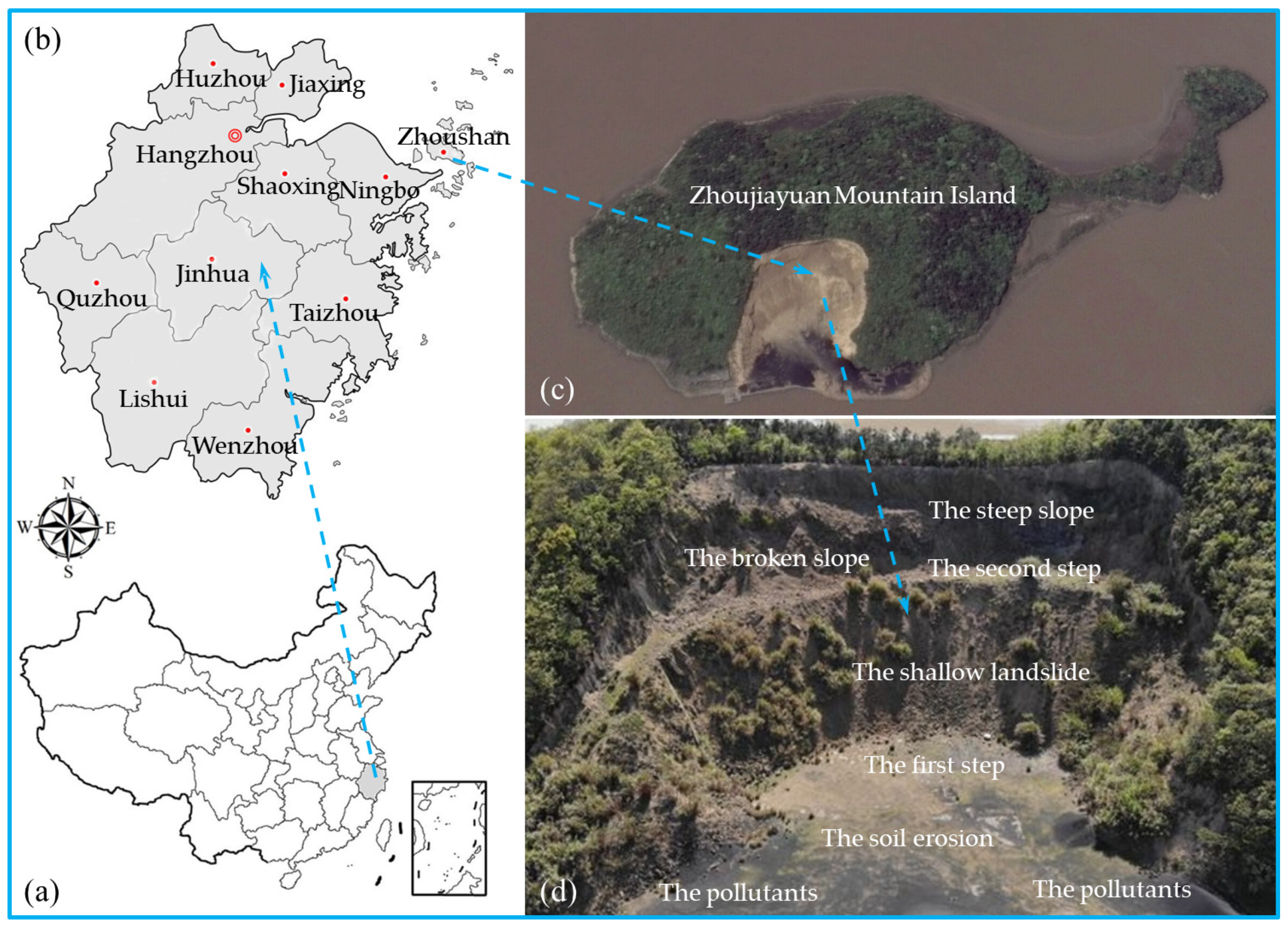
2.1. The Location and Overview of the Study Area

The study area belongs to the Zhoujiayuan Mountain Island on the southeastern coast of China. It is an uninhabited small island in the waters south of the Dinghai District, Zhoushan City, Zhejiang Province. The geographic coordinates are 122°08′51″–122°08′56″ E longitude and 29°59′02″–29°59′06″ N latitude. Its specific location is shown in Figure 1b. Zhoujiayuan Mountain is in the shape of a tadpole (as shown in Figure 1c), with a land area of 60,637 m2, coastline of 1271 m, and beach area of 24,438 m2. The highest point is 36.4 m above sea level. From the topographical point of view, it is a mountainous and hilly area; the natural terrain slope is generally 20°, and the vegetation coverage rate is about 80%. Vegetation such as wild sansho and lobular mosquito on the mountain are well developed. The water depth around the island is 2.8–13.2 m.
The mountain on the east side of Zhoujiayuan Mountain was partially destroyed by nearby residents for a stone mine in the past, resulting in exposed bedrock and soil erosion. Stone chips and coal are accumulated on the ground in front of the quarry slope, which can easily pollute the offshore environment under the action of rainwater and seawater erosion, and the ecological environment has been seriously damaged. The uninhabited island is surrounded by water and isolated from the land. There is no fresh water source on the island, and the groundwater has high salinity, which makes the productivity of the plant community extremely low and the ecosystem unstable. After years of natural restoration, the quarrying area of the abandoned mine is still dominated by bare rocks, with weeds and sparse sandy plants in between, and low biodiversity, as shown in Figure 1c,d. The eastern coast in front of the slope has also been eroded by waves, but this has little impact on the slope’s stability.
The slope of the abandoned mine is arc-shaped (Figure 1d). The overall slope aspect is about 50–70°, and the slope top is the residual soil layer with a thickness of about 0.5–1.0 m. The slope is divided into two levels of excavation. The first step extends directly to the coast, with a width ranging from 8 to 50 m, and the second step is ranges from roughly 4 to 10 m wide. Regarding slag coverage, the slope is about 40–50°, and the maximum slope height is about 16 m. The slope above the second step is relatively steep (about 75°), and the maximum slope height is about 14 m. The exposed rock mass is mostly brown-yellow strongly weathered tuff, which is severely weathered, and the local rock mass is inverted, with many joints and fissures cut.

2.2. Geological Characteristics and Disaster Analyses

To analyze the geological characteristics and potential hazards in more detail, the slope is divided into three zones (A, B, and C). This was performed according to the distribution characteristics of the excavation slope, slope direction, slope gradient, rock mass structure, geological disaster development, etc. The front view and regional geological conditions are shown in Figure 2.
According to the field investigation, the topographical geology and joint characteristics of dangerous rock mass on the slope surface of Zone A, B, and C (Figure 2b–d) are summarized and combed in Table 1 and Table 2.
The bedrock lithology of the three sections is from the Lower Cretaceous Chawan Formation (K1c), which are massive and hard rock, and the surface weathering thickness is 1–3 m. Affected by joint cutting and mechanical excavation, the rock mass is relatively broken and covered over the bedrock. Under the rainfall infiltration, there is the possibility of sliding collapse along one side of the joint in the slope of Zone B, and there is also a large probability of landslides in the broken stones and debris accumulated in the three sections.

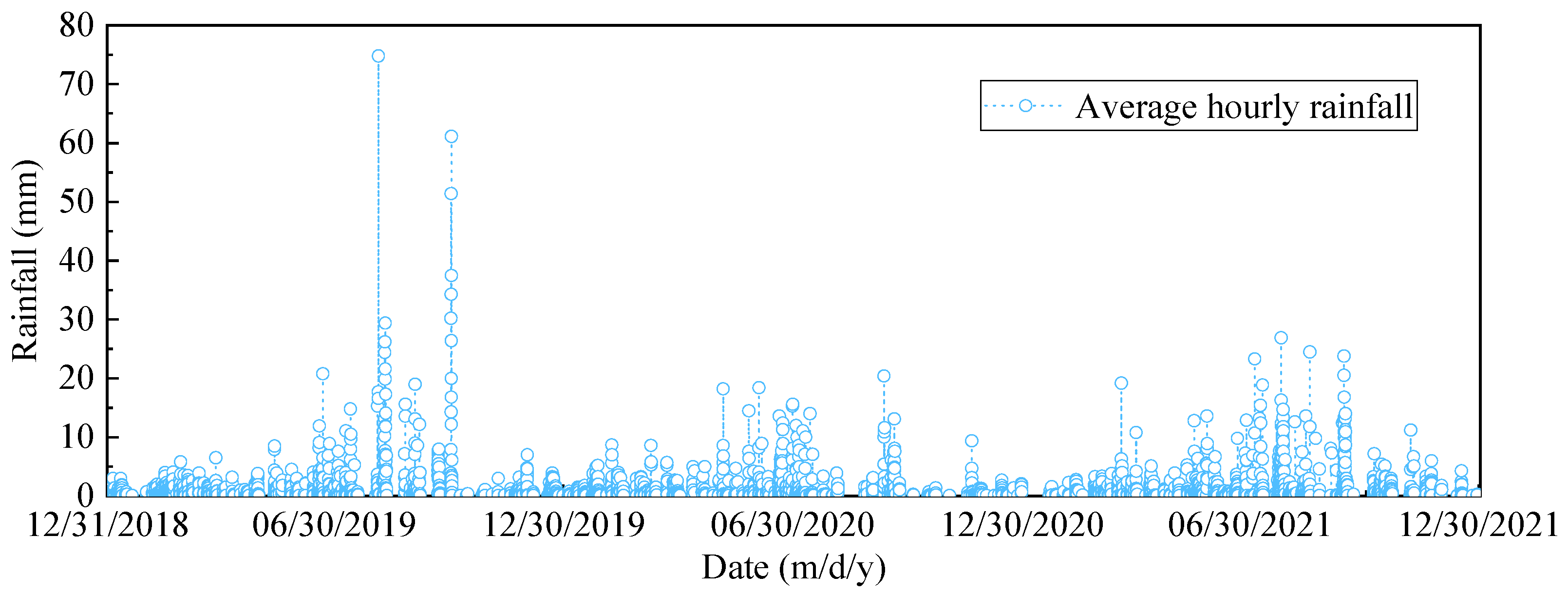
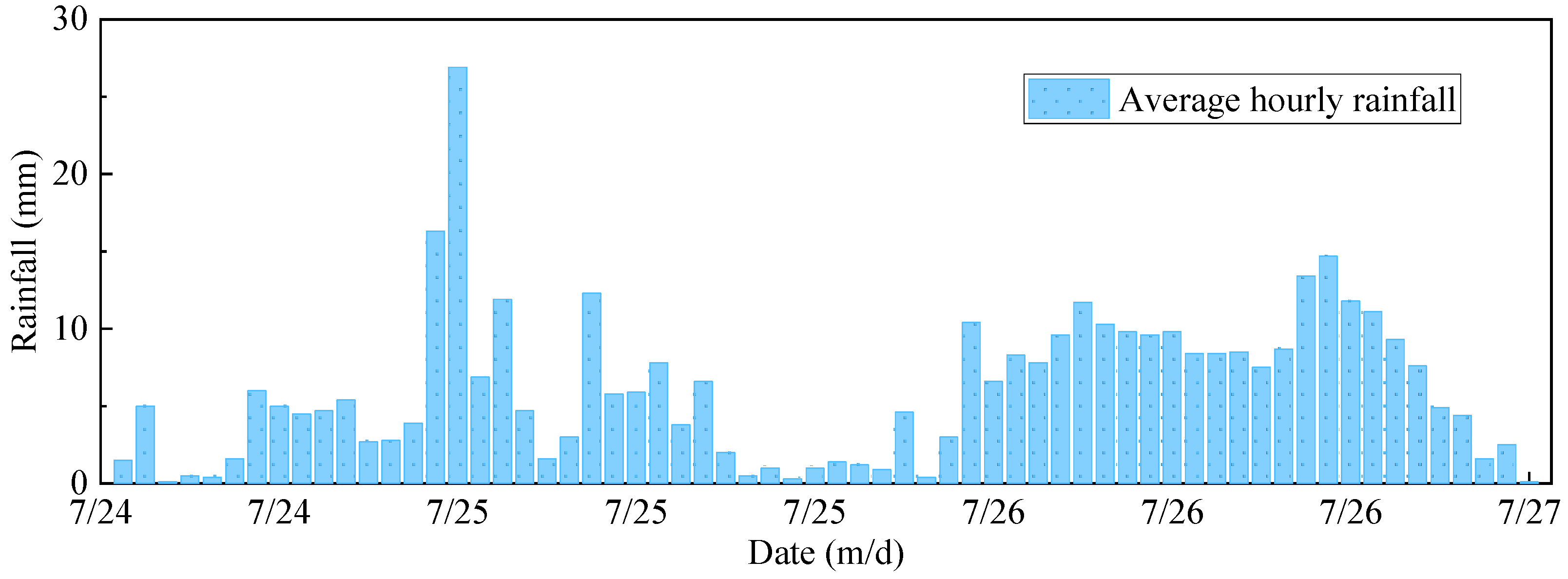
2.3. Meteorological and Hydrological Conditions

The study area is located in the marine monsoon climate zone on the southern edge of the north subtropical zone, which is warm and humid (The annual average temperature is 16.9–17.0 °C; August is the hottest month, with a monthly average of 26.9–27.5 °C; and January is the coldest month, with a monthly average of 5.4–6.5 °C). There are four distinct seasons and a sufficient amount of light. Spring precipitation is abundant and lasts for a long time. In early summer, due to cold and hot high-pressure confrontations, the result is continuous plum rain weather. The average annual precipitation is 1186.7–1293.7 mm, and the maximum annual precipitation is 1849.5–1888.9 mm, which is mainly concentrated in June (158.8–179.1 mm) and September (149.1–191.4 mm). The maximum monthly precipitation recorded is 467.2 mm (September, 1963), the average annual precipitation days is 152–155 days, and the longest continuous rainfall spans 15–18 days. The distribution of the average hourly rainfall in the study area in the past 3 years is shown in Figure 3.
The study area belongs to the coastal landform type in the front of low hills. The island land water system is not developed, and the land surface water is strongly affected by tides, meaning it is mainly characterized by marine hydrology. The highest tide level in the nearby sea area over the years was 4.43 m, the lowest tide level was 2.81 m, the average low tide level was 0.90 m, the average sea level was 1.89 m, the average tidal range was 1.90 m, and the maximum tidal range was 3.67 m. The waves in the sea are mainly local wind waves. Due to the short wind area, the waves are small, and their impact on the erosion and damage of the island is not significant.

3. Materials and Methods

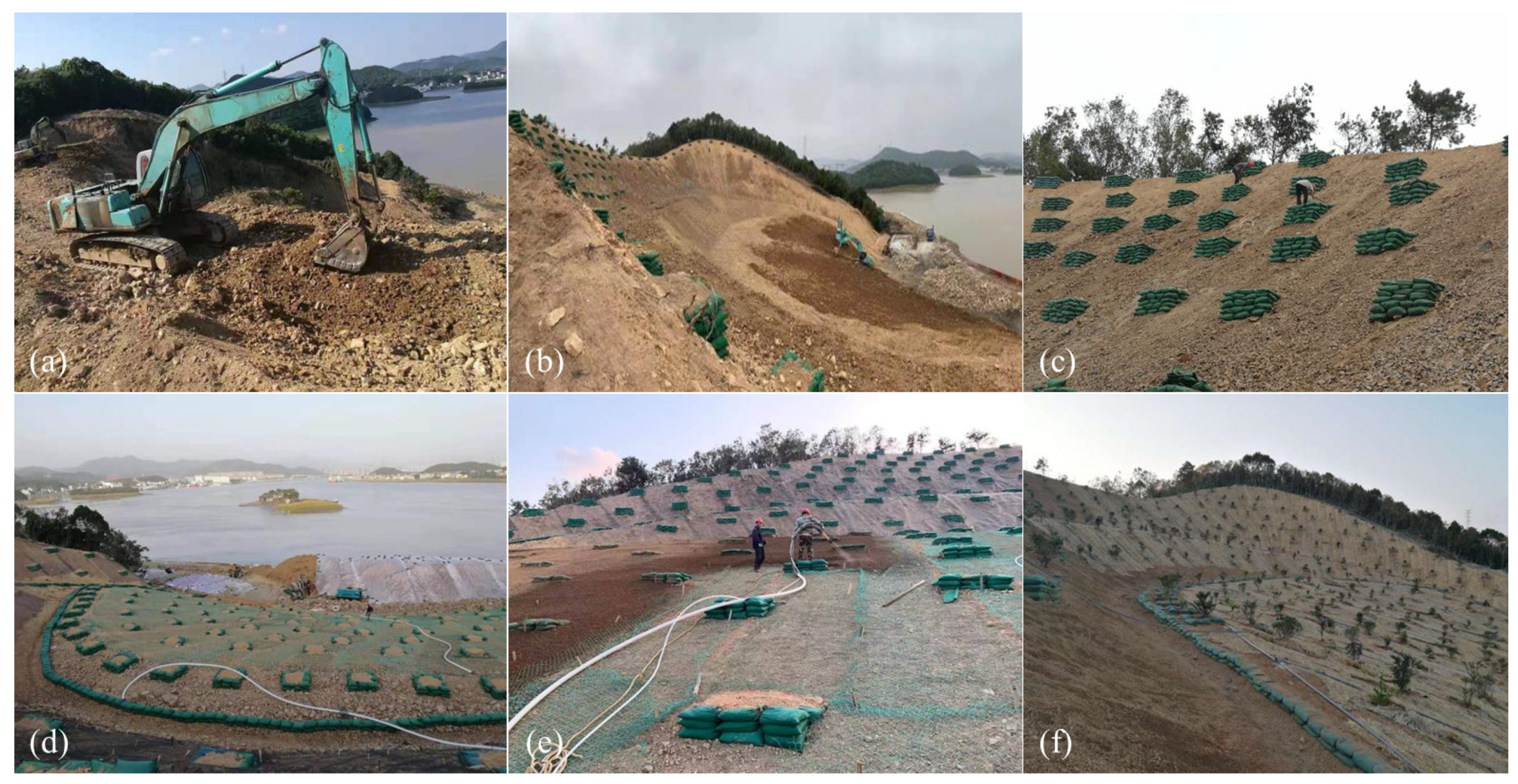
3.1. Ecological Restoration Plan for the Abandoned Mine

According to the above analysis of the landform and geological conditions of abandoned mines on Zhoujiayuan Mountain Island, the undisturbed mine slope is not conducive to vegetation growth. Therefore, when repairing the abandoned mine, engineering measures should be taken first to build stable habitat conditions. Afterwards, a numerical model can be established to analyze the slope stability and evaluate the plant habitat stability under continuous rainfall conditions. If the habitat is stable, the next process can be started; otherwise, further reinforcement measures should be taken. After seed spraying and tree planting, the maintenance should be strengthened to improve the survival rate. The repaired slope surface should be regularly observed to see whether there are pests and diseases on the vegetation and whether there are signs of soil erosion and instability on the slope surface; this is to ensure the slope’s stability and a good growth of the vegetation. The ecological restoration process is shown in Figure 4.

3.1.1. Plant Habitat Restoration

To eradicate the hidden risk of slope geological disasters, eliminate visual pollution, maintain slope balance, and restore the ecological environment, the following restoration measures were taken for different slope sections according to the properties and stability of the rock-soil mass in adverse geological conditions:
(1)
Slope cutting and cleaning. The slopes in Zone A, B, and C shall be cut according to the terrain with the principle of minimum workload, and the dangerous rock body shall be removed. Because most of the slope is angled at about 45°, to reduce the quantities it shall be designed according to a 45° slope cutting, and a step shall be added in the middle. The slope foot shall be leveled with slag.
(2)
According to the existing research results [33], a certain thickness of soil helps to improve the structure and stability of soil aggregates. Covering the planting soil with a thickness of more than 60 cm can basically meet the growth needs of various plants. Therefore, when repairing the mine slope, it is required that the covering thickness of the planting soil should not be less than 50 cm, and the thickness of the spray mixed planting material should not be less than 15 cm.
(3)
The ecological retaining wall is built with on-site block stones 2.0 m outside the foot line of the upstream slope with a design length of 110 m. The stone shall be hard and not easily weatherable. The upper and lower surfaces are roughly flat, with a thickness of no less than 20 cm and a strength grade of at least MU 30. Its foundation is 0.3 m deep, 1.0 m wide, 1.0 m high, 0.6 m wide at the top, and 0.8 m wide at the bottom.
It is necessary to evaluate the stability of the soil-covered slope before construction due to the abundant rainfall in the study area. If the stability requirements can be met, greening shall be carried out on the soil covered slope. Otherwise, it should be carried out after further reinforcement measures are taken.

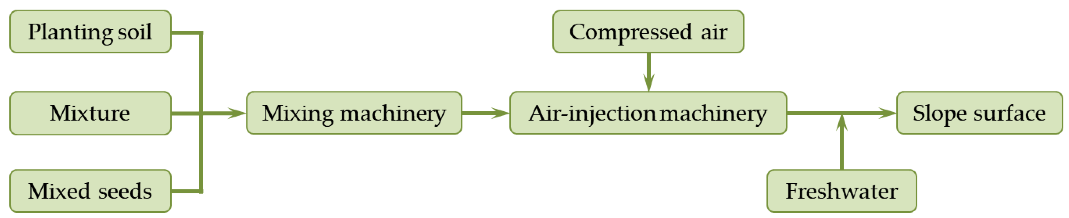
3.1.2. Plant Selection and Construction Technology

The diversity selection of plant species and structures is conducive to the stability and rapid restoration of the slope ecology [34]. Therefore, a plant combination composed of herbs, shrubs, and trees was used in the ecological restoration of the soil covered slope. On the basis of a stable plant habitat, spray mixed vegetation materials were used to carry out the ecological restoration of the mountain. The specific process is shown in Figure 5.
The soil in Figure 5 is topsoil-rich in seeds or effective planting soil with a high organic matter content. The mixture included matrix materials (mainly peat soil, grass fiber, and livestock manure), fertilizers, water retaining agents, adhesives, etc. The mixed seeds were selected according to the climate, hydrological conditions, existing vegetation types, and construction time near the study area, as shown in Table 3.
The percentages of the above components, in unit volume, are shown in Table 4.
In addition to the above plants, trees and shrubs such as Ligustrum lucidum, Casuarina equisetifolia, and Pittosporum were planted at the slope foot, secondary steps, and some of the gentle slopes, with a plant spacing of 3 m. They were arranged in a plum blossom shape on the slope and planted in a row on the second step and slope foot.

3.2. Stability Analyses of the Plant Habitat

To verify the stability of the soil-covered slope after slope cutting combined with the rainfall characteristics near the island, a numerical model was established to quantitatively reveal the evolution process of the stability safety factor of the rock slope after soil covering.

3.2.1. Transient Seepage Equation of Saturated-Unsaturated Soil

The movement of water in soil can be described by the flow control equation. The generalized two-dimensional seepage differential equation based on Darcy’s law can be used to describe the transient flow of water under saturated-unsaturated conditions at any position in the soil profile [35,36,37]:
x k w x H x   + y k w y H y   + Q w = θ w t
where H is the total head, in m; k w x , k w y are the permeability coefficients in the x and y directions, respectively, in cm/s; Q w is the unit volume flow applied on the boundary, represented as 1/s; t is the time, in seconds; and θ w is the water content per unit volume of soil, in a percentage. Its value is calculated by the van Genuchten model [38,39]:
θ w = θ r + θ s θ r 1 + α ψ n m
where ψ is the matrix suction, ψ = u a u w , in kPa; α is the parameter related to the intake value, in 1/kPa; n , m are curve fitting parameters, m = 1 1 / n ; θ s is the saturated volume water content of soil, in a percentage; and θ r is the residual volume water content of soil, in a percentage.
The seepage coefficient of saturated-unsaturated soil is calculated based on the van Genuchten empirical model [40]:
k = k s S e 0.5 1 1 S e 1 / m m 2
where k , k s are the permeability coefficients of the unsaturated and saturated soil, respectively, in cm/s;   S e is the relative saturation, in a percentage, and its expression is as follows [41]:
  S e = θ w θ r θ s θ r = 1 1 + α ψ n m

3.2.2. Stability Calculation Model

Rainfall infiltration changes the soil matrix suction [42], which has a significant impact on the shear strength [43,44]. The soil shear strength is directly related to the slope stability. Therefore, considering the influence of the matrix suction change during rainfall can accurately reflect the stress state of the soil-covered slope. The modified Mohr-Coulomb criterion is used to describe the shear strength of the saturated-unsaturated soil [45,46]:
τ s = c + σ n u a t a n ϕ + u a u w t a n ϕ b
where τ s is the shear strength, in kPa; c is the effective cohesion, in kPa; ϕ is the effective internal friction angle, in degrees; σ n is the normal stress at the bottom center of each block, in kPa; u a is the pore gas pressure, in kPa; and ϕ b is the internal friction angle corresponding to the matrix suction, in degrees. The following forms are often used in calculation [47,48]:
t a n ϕ b = θ w θ r θ s θ r t a n ϕ
The slope stability is usually evaluated by the safety factor [49,50], and the expression of its value calculated by the finite element method is as follows [51]:
F s = S r S m
where F s is the safety factor; S r is the anti-sliding shear force on the central soil mass at the bottom of each strip along a possible sliding surface, in kN, S r = d τ s ,  d is the bottom length of each strip, in m; S m is the sliding shear force acting on the soil mass at the bottom center of each strip on the sliding surface, in kN, S m = d τ m ,  τ m is the sliding shear stress on the central soil mass at the bottom of the strip, in kPa.

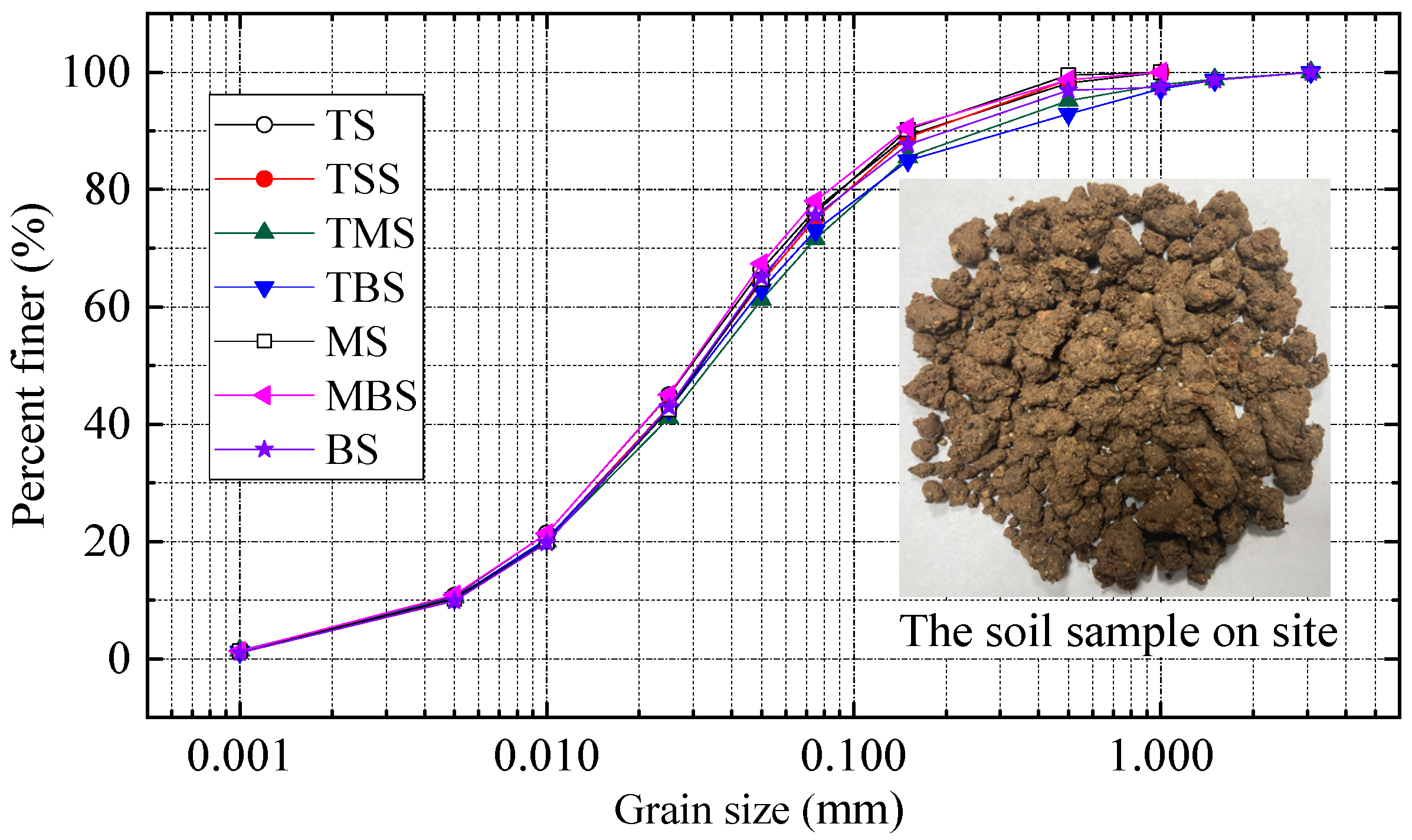
3.2.3. Calculation Parameters

(1)
Geometric parameters
The lower part of the abandoned mine on the island is basically hard rock mass after the slope cutting and excavation, and the upper part is covered with planting soil with a thickness of 0.6–1.5 m. The typical cross-section of the abandoned mine after soil covering was chosen, and a numerical model was established, as shown in Figure 6.
(2)
Basic properties of the rock and soil mass
The soil covering layer selected and improved on-site was sampled from bottom to top along the slope, and the particle analysis was carried out in the laboratory with a laser particle size analyzer. The particle grading curve is shown in Figure 7. In the figure, TS represents the soil samples in the middle of the slope top’s platform, and the elevation was 30.0 m; TSS refers to the soil sample at the top of the uppermost slope, and its elevation was 28.0 m; TMS represents the soil sample in the middle of the uppermost slope, and its elevation was 23.0 m; TBS expresses the soil sample at the lower part of the uppermost slope, and its elevation was 17.0 m; MS refers to the soil sample of the slope in the middle of the mountain, where the elevation was 15.0 m; MBS represents the soil sample of the slope at the elevation of 8.0 m; BS refers to the soil sample of the lower slope of the mountain, where the elevation was 4.5 m.
It can be seen from Figure 7 that the particles of the improved soil mass of the slope overburden were evenly distributed along the space and that the particle size range was basically the same. The physical and mechanical performance parameters of the rock and soil mass of the numerical model were determined in combination with the field investigation data and laboratory tests, as shown in Table 5. The rooted soil in Table 1 was obtained through field sampling. After the rainfall settlement and consolidation, the soil physical and mechanical properties were dramatically changed.
(3)
Hydraulic parameters
The seepage coefficient of the rock and soil mass in a typical geological cross-section is shown in Table 6.
The soil water characteristic curve (SWCC) of the covered soil was obtained by measuring the reshaped soil sample using the pressure plate method. Then, the parameters of the van Genuchten empirical model were fitted and predicted by utilizing the SWCC, as shown in Figure 8a. The relationship curves between the seepage coefficient and matrix suction, as calculated by Formula (3), are shown in Figure 8b.

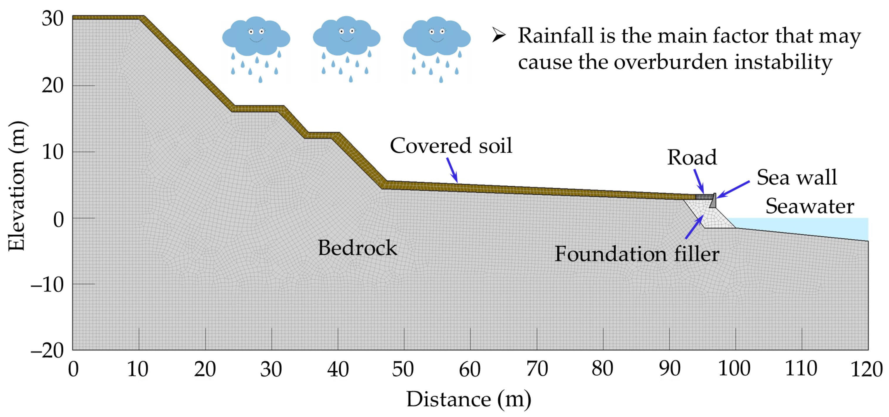
3.2.4. Boundary Conditions

(1)
Hydraulic boundary conditions
According to the hydrometeorology and geographical environment, the study area is located in the rainy region, and the main factor affecting the instability of the soil-covered slope is continuous rainfall. From Figure 3, the hourly cumulative maximum rainfall in the past 3 years was selected as the rainfall boundary condition, as shown in Figure 9.
(2)
Stress/Strain boundary conditions
The horizontal displacement constraints were applied at the left and right ends of the slope, and horizontal and vertical constraints were applied at the bottom.

4. Results and Discussions

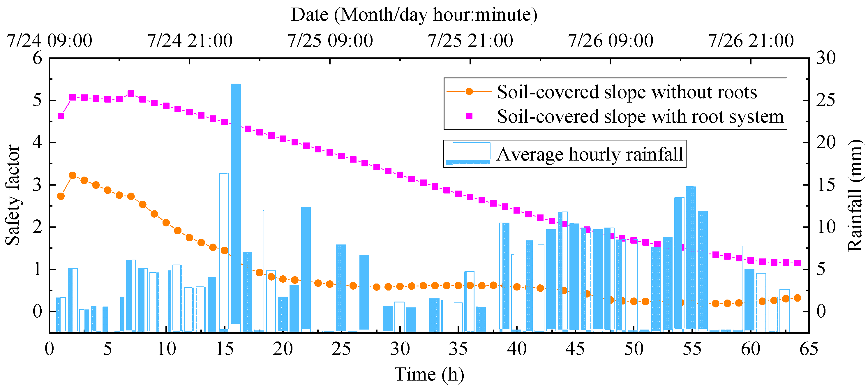
4.1. Stability of the Soil Covered Slope

The water field analysis was carried out using the Seep/W model, the stress field was calculated using the Sigma/W model, and the stability calculation was carried out using Slope/W model. According to Formulas (5) and (6), the varying water field will lead to a change in the matrix suction, which will directly affect the soil shear strength. According to Formula (7), the stability of the soil-covered slope is directly related to the soil shear strength. Therefore, we examined the stability safety factor of the soil-covered slope with and without root system changes over time during rainfall, as shown in Figure 10. It can be seen from the figure that the covered soil slope had a high stability safety factor at the beginning of rainfall. With continuous rainfall, the moisture content of the covered soil gradually increased and tended to be saturated, and the matrix suction significantly decreased, resulting in the continuous decline of the shear strength and gradual reduction of its stability safety factor. The safety factor was reduced to 1.02 after continuous rainfall for 17 h, and the slope was in a critical instability state. After continuous rainfall for 18 h, the safety factor was reduced to 0.92, and the instability risk of the soil-covered slope was very high. Overall, the safety factor of the soil-covered slope showed a downward trend with continuous rainfall. When the ecological restoration of the rock slope was completed, considering the strong soil consolidation effect of vegetation roots, the slope stability was greatly improved. After 64 h of continuous rainfall, the stability safety factor of the soil-covered slope with the root system was close to 1.15, which can remain stable. However, in the first year of ecological restoration, the root system of vegetation is not yet developed (Sowing and planting were completed in July 2019). The roots of the seedlings are short and thin, and there is less intertwining between vegetation roots. The length of the seedling root system generally does not exceed 10 cm. Thus, the risk of landslide and soil erosion is still high when encountering rainfall. Further reinforcement measures were needed for the soil-covered slope.

4.2. Soil-Covered Slope Reinforcement and Ecological Restoration Measures

From the above analysis, it can be seen that when the plants were planted on the slope after renovation, the root system was not developed at the initial stage of plant growth. This can easily cause landslides and soil erosion during rainfall, which is not conducive to the slope stability. Therefore, it was necessary to further strengthen the soil-covered slope to prevent its instability and damage at the initial stage of ecological restoration. If the above slope cutting method is adopted to reduce the slope gradient (Figure 11a,b), the construction cost will be greatly increased and the construction period will be longer. To cut down the construction cost, shorten the construction period, and reduce the amount of mountain excavation, the slope body was gently treated and three-dimensionally protected by building vegetation bag cofferdams at the slope foot and surface. The cofferdam spacing was 3.0 m × 3.0 m, which was arranged in a cross pattern. The high-quality planting soil and peat soil were evenly mixed in the proportion of 7:3. Then, the mixed improved soil was loaded with a specification of 0.4 m × 0.6 m into a PVC mesh bag. The planting bag placing area should be manually excavated and leveled. It should be stacked in a trapezoid and stably placed by pressing seams. The vegetation bag cofferdam was 1.0 m long, 0.5 m wide, and the stacking height was greater than 0.5 m. After the cofferdam was built, the planting soil should be backfilled with the backfill height being no less than 0.5 m (Figure 11c).
After the above process is completed, we laid the PVC-plated rhombic wire mesh with an aperture size of 5 cm × 5 cm on the slope. The mesh length should be cut according to the needs, and the extension of the slope top should not be less than 50 cm. It should be backfilled after trenching and fixing with piles. After the slope top was fixed, it was laid from top to bottom. The lap width between the left and right pieces should not be less than 10 cm. After the grid was laid, L-shaped steel anchors with a diameter of 6.0–6.5 mm and a length of 120–300 mm were used to fix the grid in place. The horizontal spacing of the anchor nails on the slope top was 50 cm, and the spacing of lap joints on the slope surface was 100 cm. The rest positions were arranged in a quincunx shape of 4–5 pieces/m2, and the embedding was greater than 8 cm. For individual uneven slopes, anchors must be added to make the barbed wire mesh adhere to the slope and maintain a gap of 3–4 cm with the slope (Figure 11d).
After the nail net was completed, spray mixed planting could be carried out (Figure 11e). After mixing the matrix with water retaining agent, binder, plant fiber, peat soil, humus soil, slow-release compound fertilizer, and seeds in proper proportions, we sprayed the mixture mixed with water on the slope surface and wire mesh by spraying it with high compressed air equipment. The spray was formed in one operation. The average thickness of the sprayed mixture on the slope was 15 cm. During the process, the mixing proportion of materials should be strictly controlled, and the water consumption should be subject to the best bonding of the matrix to the rock surface, without flowing.
At the slope foot, the second step, and some of the gentle slopes, trees and shrubs such as Ligustrum lucidum, Casuarina equisetifolia, and Pittosporum tobira were planted with a plant spacing of 3 m (Figure 11f). They were arranged in a plum blossom shape on the slope, and arranged in a row on the second step and slope foot. The pillars were set in the downwind direction and firmly supported to prevent the tree from being tilted by strong winds. After planting, sufficient water was poured in time.
The maintenance and management are essential for making the plant seeds germinate smoothly, pass the seedling period, and quickly regain green after the ecological restoration construction is completed. To prevent the seedlings from normally sprouting and growing due to the scouring of the slope by heavy rain, the protective net should be covered on the slope, and the protective net should be removed after the seedlings grow to 4–5 cm long. During this period, attention should be paid to the watering method and amount. Sufficient water should be ensured to make the seeds germinate; too much water should not be accumulated or they can form surface runoff that washes away the soil particles and seeds on the slope, or cause unevenness and form partial bald spots. For the dry season, the watering frequency should be appropriately increased; in the rainy season, the frequency should be appropriately reduced, and the pest and disease prevention measures should be performed. The position of seedling emergence or survival rate should be replanted.

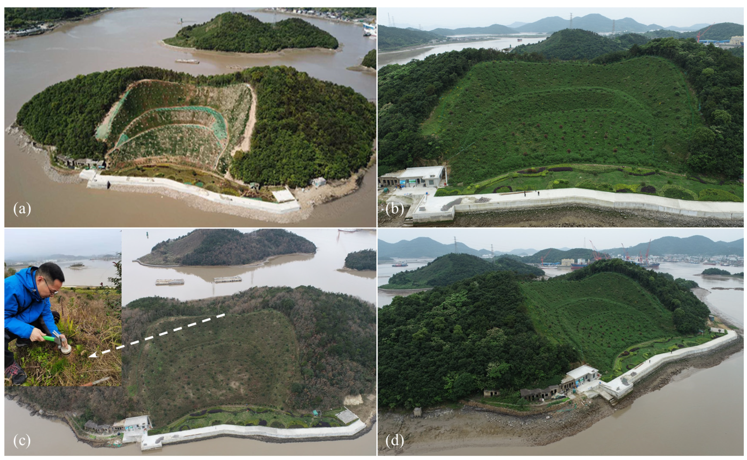
4.3. Ecological Restoration Effect of the Soil-Covered Slope

The ecological restoration effect is remarkable according to the observation of the above soil-covered slope reinforcement and ecological restoration measures, and the observations over the 3 years of implementation are shown in Figure 12.
In July 2019, after spraying the seed mixture and planting the shrubs and trees on the slope, the seed germination and seedling emergence rates met the requirements of the design scheme, and the planted shrubs and trees also basically survived. In April 2020, the vegetation on the slope grew well (Figure 12a), and the root system was developed. There were no obvious traces of soil erosion and signs of landslides found on the slope after several continuous rains. In May 2021, the vegetation on the slope was very lush and was able to cover the ground (Figure 12b), and the vegetation diversity had increased. After rainfall, no traces of soil erosion were found, and the slope remained stable. In January and March, when the temperature is low, some plants wither, but a large number of plants remain green because of the many different types of plants that were used for the slope restoration (Figure 12c). It reflects the role of plant diversity in ecological restoration. In May 2022, the flowers and plants were very lush, and the ground was completely covered by vegetation (Figure 12d). The plant diversity had significantly increased, and the leaf crown of the shrubs and trees had grown to twice the size as when they were planted. No trace of soil erosion was found after rainfall, and there was no sign of sliding. The observation results of nearly three years show that the ecological restoration technology of the abandoned rock mine slope in the Zhoujiayuan Mountain Island case is correct and reasonable, which has a certain reference significance for the ecological restoration of abandoned rock mines in rainy regions.

5. Conclusions

The slope on the abandoned mine of Zhoujiayuan Mountain Island has been seriously damaged by local quarrying; this has caused visual pollution and frequent soil erosion during rainfall, and there is a risk of collapse. This study aimed to present a methodology for assessing the stability and ecological restoration of the soil-covered rocky slope of an abandoned mine on islands in rainy regions. Based on indoor tests and field investigation data, the study carried out an ecological restoration of the abandoned mine. Furthermore, it quantitatively analyzed the stability evolution law of the soil-covered slope before and after the ecological restoration in the raining process according to the local hydrological and meteorological characteristics, putting forward further slope reinforcement and ecological restoration measures. The stability safety factor of the soil-covered slope gradually declined in the case of continuous rainfall. After continuous rainfall for 18 h, the safety factor decreased to 0.92, and there was an extremely high risk of instability. The vegetation root system has the function of soil fixation, and its stability is dramatically raised after the ecological restoration of the slope. However, at the beginning of ecological restoration, measures should be taken to enhance the slope stability. We adopted a method of a gentle treatment and three-dimensional protection of the slope body by building a vegetation bag cofferdam at the slope foot and surface. The planting soil and peat soil were evenly mixed at a ratio of 7:3 and then placed in PVC mesh bags; these bags were neatly stacked in a trapezoidal manner, and the planting soil was backfilled around, which can slow down and stabilize the slope. PVC-plated wire mesh and L-shaped steel anchors were used to jointly protect the slope. The mixture was bound to the slope surface and wire mesh by spraying it with high compressed air equipment after mixing the mixed matrix with water retaining agent, binder, plant fiber, peat soil, humus soil, slow-release compound fertilizer, and seeds in proper proportions. The average thickness of the mixture on the slope was 15 cm. Shrubs and trees were planted at the slope foot, secondary steps, and some of the gentle slopes to increase the ecological structure diversity. To prevent the seedlings from normally sprouting and growing due to the scouring of the slope by heavy rain, it was necessary to cover the slope with a protective net and remove it after the seedlings grow to 4–5 cm. On the basis of the on-site observation from 2019 to 2022, the ecological recovery of the abandoned rock mine slope of Zhoujiayuan Mountain Island is successful; the vegetation is flourishing, and its diversity has been greatly increased. There was no soil erosion or slope instability found after several continuous rainfall processes. This research can provide a reference and theoretical basis for similar mine restoration projects in rainy regions.

Author Contributions

Writing—original draft preparation, X.L.; writing—review and editing, Y.T. and Z.Q.; funding acquisition, Z.Q. and J.S.; formal analysis, G.J. and W.S.; investigation, H.Z. (Hongwei Zhang), H.Z. (Haitao Zhao) and Z.Q.; resources, X.G. and J.Z. All authors have read and agreed to the published version of the manuscript.

Funding

This research was supported by the Scientific Research Foundation of Zhejiang University of Water Resources and Electric Power (xky2022013) and Major Science and Technology Plan Project of Zhejiang Provincial Department of Water Resources (RA1904).

Acknowledgments

The authors thank PowerChina Huadong Engineering Corporation and the construction company for their support.

Conflicts of Interest

The authors declare that there are no conflict of interest regarding the publication of this paper.

References

  1. Visser Jenneke, M.; Duke-Sylvester Scott, M. LaVegMod v2: Modeling coastal vegetation dynamics in response to proposed coastal restoration and protection projects in Louisiana, USA. Sustainability 2017, 9, 1625. [Google Scholar] [CrossRef] [Green Version]
  2. Barnaud, G.; Chapuis, J.L. Scientific and ethic issues on the restoration of island ecosystems. The eradication of introduced mammals in the Subantarctic islands. Vie Milieu-Life Environ. 1996, 46, 291–303. [Google Scholar]
  3. Neghme, C.; Santamaria, L.; Calvino-Cancela, M. Strong dependence of a pioneer shrub on seed dispersal services provided by an endemic endangered lizard in a Mediterranean island ecosystem. PLoS ONE 2017, 12, e0183072. [Google Scholar] [CrossRef] [PubMed] [Green Version]
  4. Li, X.; Shen, T.; Zhang, H.; Shen, J.; Sun, W. Study on Ecological Restoration Technology of uninhabited island in Zhoushan: A case study of ecological restoration in quarry area of Zhoujiayuan Mountain. Yangtze River 2020, 51, 53–56. (In Chinese) [Google Scholar]
  5. Otto, R.; Barone, R.; Delgado, J.-D.; Arevalo, J.-R.; Garzon-Machado, V.; Cabrera-Rodriguez, F.; Fernandez-Palacios, J.-M. Diversity and distribution of the last remnants of endemic juniper woodlands on Tenerife, Canary Islands. Biodivers. Conserv. 2012, 21, 1811–1834. [Google Scholar] [CrossRef]
  6. Buxton, R.T.; Jones, C.J.; Lyver PO, B.; Towns, D.R.; Borrelle, S.B. Deciding when to lend a helping hand: A decision-making framework for seabird island restoration. Biodivers. Conserv. 2016, 25, 467–484. [Google Scholar] [CrossRef]
  7. Bai, J.G.; Wang, J.J.; Zhang, Y.L.; Ji, X.D.; Wen, N. Decision analysis of slope ecological restoration based on AHP. Sains Malays. 2017, 46, 2075–2081. [Google Scholar] [CrossRef] [Green Version]
  8. Liu, X.; Zhou, W.; Bai, Z. Vegetation coverage change and stability in large open-pit coal mine dumps in China during 1990–2015. Ecol. Eng. 2016, 95, 447–451. [Google Scholar] [CrossRef]
  9. Wang, J.; Schweizer, D.; Liu, Q.; Su, A.; Hu, X.; Blum, P. Three-dimensional landslide evolution model at the Yangtze River. Eng. Geol. 2021, 292, 106275. [Google Scholar] [CrossRef]
  10. da Silva, A.C.; Resende, I.; da Costa, R.C.; Uagoda, R.E.S.; de Souza Avelar, A. Geophysical for granitic joint patern and subsurface hydrology related to slope instability. J. Appl. Geophys. 2022, 199, 104607. [Google Scholar] [CrossRef]
  11. Marino, P.; Comegna, L.; Damiano, E.; Olivares, L.; Greco, R. Monitoring the Hydrological Balance of a Landslide-Prone Slope Covered by Pyroclastic Deposits over Limestone Fractured Bedrock. Water 2020, 12, 3309. [Google Scholar] [CrossRef]
  12. Marino, P.; Santonastaso, G.F.; Fan, X.; Greco, R. Prediction of shallow landslides in pyroclastic-covered slopes by coupled modeling of unsaturated and saturated groundwater flow. Landslides 2020, 18, 31–41. [Google Scholar] [CrossRef]
  13. Song, Z.; Li, X.; Lizárraga, J.J.; Zhao, L.; Buscarnera, G. Spatially distributed landslide triggering analyses accounting for coupled infiltration and volume change. Landslides 2020, 17, 2811–2824. [Google Scholar] [CrossRef]
  14. Damiano, E.; Greco, R.; Guida, A.; Olivares, L.; Picarelli, L. Investigation on rainwater infiltration into layered shallow covers in pyroclastic soils and its effect on slope stability. Eng. Geol. 2017, 220, 208–218. [Google Scholar] [CrossRef]
  15. Wang, M.; Liu, Q.; Pang, X. Evaluating ecological effects of roadside slope restoration techniques: A global meta-analysis. J. Environ. Manag. 2021, 281, 111867. [Google Scholar] [CrossRef] [PubMed]
  16. Rahardjo, H.; Satyanaga, A.; Wang, C.L.; Wong JL, H.; Lim, V.H. Effects of unsaturated properties on stability of slope covered with Caesalpinia crista in Singapore. Environ. Geotech. 2020, 7, 393–403. [Google Scholar] [CrossRef]
  17. Sanchez-Castillo, L.; Kosugi, K.I.; Masaoka, N.; Kubota, T. Eco-morphological characteristics of fern species for slope conservation. J. Mt. Sci. 2019, 16, 504–515. [Google Scholar] [CrossRef]
  18. Tang, V.T.; Fu, D.; Ngoc Binh, T.; Rene, E.R.; Sang TT, T.; Singh, R.P. An investigation on performance and structure of ecological revetment in a sub-tropical area: A case study on Cuatien River, Vinh City, Vietnam. Water 2018, 10, 636. [Google Scholar] [CrossRef] [Green Version]
  19. Xu, R.; Li, X.; Yang, W.; Jiang, C.; Rabiei, M. Use of local plants for ecological restoration and slope stability: A possible application in Yanan, Loess Plateau, China. Geomat. Nat. Hazards Risk 2019, 10, 2106–2128. [Google Scholar] [CrossRef] [Green Version]
  20. Chen, S.; Ai, X.; Dong, T.; Li, B.; Luo, R.; Ai, Y.; Chen, Z.; Li, C. The physico-chemical properties and structural characteristics of artificial soil for cut slope restoration in Southwestern China. Sci. Rep. 2016, 6, 20565. [Google Scholar] [CrossRef] [Green Version]
  21. Zhou, C.; Li, D.; Liu, Z. Quantitative characterization of the aqua-dispersing nano-binder effects on the slip resistance of borrowed soil of a rock slope. Appl. Sci.-Basel 2019, 9, 3618. [Google Scholar] [CrossRef] [Green Version]
  22. Faiz, H.; Ng, S.; Rahman, M. A state-of-the-art review on the advancement of sustainable vegetation concrete in slope stability. Constr. Build. Mater. 2022, 326, 126502. [Google Scholar] [CrossRef]
  23. Chen, F.; Xu, Y.; Wang, C.; Mao, J. Effects of concrete content on seed germination and seedling establishment in vegetation concrete matrix in slope restoration. Ecol. Eng. 2013, 58, 99–104. [Google Scholar] [CrossRef]
  24. Kil, S.H.; Lee, D.K.; Kim, J.H.; Li, M.H.; Newman, G. Utilizing the analytic hierarchy process to establish weighted values for evaluating the stability of slope revegetation based on hydroseeding applications in South Korea. Sustainability 2016, 8, 58. [Google Scholar] [CrossRef] [Green Version]
  25. Gasmo, J.M.; Rahardjo, H.; Leong, E.C. Infiltration effects on stability of a residual soil slope. Comput. Geotech. 2000, 26, 145–165. [Google Scholar] [CrossRef]
  26. Liu, Z.Z.; Yan, Z.X.; Duan, J.; Qiu, Z.H. Infiltration regulation and stability analysis of soil slope under sustained and small intensity rainfall. J. Cent. South Univ. 2013, 20, 2519–2527. [Google Scholar] [CrossRef]
  27. Zhang, G.R.; Qian, Y.J.; Wang, Z.C.; Zhao, B. Analysis of rainfall infiltration law in unsaturated soil slope. Sci. World J. 2014, 2014, 567250. [Google Scholar] [CrossRef] [Green Version]
  28. Wu, L.Z.; Selvadurai, A.P.S.; Zhang, L.M.; Huang, R.Q.; Huang, J.S. Poro-mechanical coupling influences on potential for rainfall-induced shallow landslides in unsaturated soils. Adv. Water Resour. 2016, 98, 114–121. [Google Scholar] [CrossRef]
  29. Zhang, L.L.; Zhang, J.; Zhang, L.M.; Tang, W.H. Stability analysis of rainfall-induced slope failure: A review. Proc. Inst. Civ. Eng.-Geotech. Eng. 2011, 164, 299–316. [Google Scholar] [CrossRef] [Green Version]
  30. Zhang, J.; Zhu, D.; Zhang, S. Shallow slope stability evolution during rainwater infiltration considering soil cracking state. Comput. Geotech. 2019, 117, 103285. [Google Scholar] [CrossRef]
  31. Rahardjo, H.; Ong, T.H.; Rezaur, R.B.; Leong, E.C.; Fredlund, D.G. Response parameters for characterization of infiltration. Environ. Earth Sci. 2010, 60, 1369–1380. [Google Scholar] [CrossRef]
  32. Tian, D.; Zheng, H.; Liu, D. A 2D integrated FEM model for surface water-groundwater flow of slopes under rainfall condition. Landslides 2017, 14, 577–593. [Google Scholar] [CrossRef]
  33. Zhang, Y.; Li, P.; Liu, X.; Xiao, L. Changes in soil aggregate fractions, stability, and associated organic carbon and nitrogen in different land use types in the Loess Plateau, China. Sustainability 2022, 14, 3963. [Google Scholar] [CrossRef]
  34. Li, R.; Kan, S.; Zhu, M.; Chen, J.; Ai, X.; Chen, Z.; Zhang, J.; Ai, Y. Effect of different vegetation restoration types on fundamental parameters, structural characteristics and the soil quality index of artificial soil. Soil Tillage Res. 2018, 184, 11–23. [Google Scholar] [CrossRef]
  35. Filho, O.A.; Fernandes, M.A. Landslide analysis of unsaturated soil slopes based on rainfall and matric suction data. Bull. Eng. Geol. Environ. 2019, 78, 4167–4185. [Google Scholar] [CrossRef]
  36. Bahrami, S.; Ardejani, F.D.; Baafi, E. Application of artificial neural network coupled with genetic algorithm and simulated annealing to solve groundwater inflow problem to an advancing open pit mine. J. Hydrol. 2016, 536, 471–484. [Google Scholar] [CrossRef] [Green Version]
  37. GEO-SLOPE International Ltd. Seepage Modeling with SEEP/W: An Engineering Methodology (July 2012 Edition); GEO-SLOPE International Ltd.: Calgary, AB, Canada, 2012; pp. 171–173. [Google Scholar]
  38. Wu, X.; Xia, J.; Zhan, C.; Jia, R.; Li, Y.; Qiao, Y.; Zou, L. Modeling soil salinization at the downstream of a lowland reservoir. Hydrol. Res. 2019, 50, 1202–1215. [Google Scholar] [CrossRef]
  39. Qin, Z.; Lai, Y.; Tian, Y.; Zhang, M. Stability behaviour of a reservoir soil bank slope under freeze-thaw cycles in cold regions. Cold Reg. Sci. Technol. 2020, 181, 103181. [Google Scholar] [CrossRef]
  40. Rivera-Hernandez, X.A.; Ellithy, G.S.; Vahedifard, F. Integrating field monitoring and numerical modeling to evaluate performance of a levee under climatic and tidal variations. J. Geotech. Geoenviron. Eng. 2019, 145, 05019009. [Google Scholar] [CrossRef]
  41. Chinkulkijniwat, A.; Tirametatiparat, T.; Supotayan, C.; Yubonchit, S.; Horpibulsuk, S.; Salee, R.; Voottipruex, P. Stability characteristics of shallow landslide triggered by rainfall. J. Mt. Sci. 2019, 16, 2171–2183. [Google Scholar] [CrossRef]
  42. Satyanaga, A.; Rahardjo, H. Stability of unsaturated soil slopes covered with Melastoma malabathricum in Singapore. Proc. Inst. Civ. Eng.-Geotech. Eng. 2019, 172, 530–540. [Google Scholar] [CrossRef]
  43. Zhang, G.; Wang, R.; Qian, J.; Zhang, J.M.; Qian, J. Effect study of cracks on behavior of soil slope under rainfall conditions. Soils Found. 2012, 52, 634–643. [Google Scholar] [CrossRef]
  44. Zhu, P.; Witt, K.J. The effect of depth dependency on stochastic infinite slope stability analysis. Environ. Geotech. 2019, 6, 307–319. [Google Scholar] [CrossRef]
  45. Toll, D.G.; Md Rahim, M.S.; Karthikeyan, M.; Tsaparas, I. Soil-atmosphere interactions for analyzing slopes in tropical soils in Singapore. Environ. Geotech. 2019, 6, 361–372. [Google Scholar] [CrossRef] [Green Version]
  46. Li, D.Q.; Wang, L.; Cao, Z.J.; Qi, X.H. Reliability analysis of unsaturated slope stability considering SWCC model selection and parameter uncertainties. Eng. Geol. 2019, 260, 105207. [Google Scholar] [CrossRef]
  47. Lu, N.; Likos, W.J. Unsaturated Soil Mechanics; John Wiley & Sons, Inc.: Hoboken, NJ, USA, 2004; pp. 229–247. [Google Scholar]
  48. Qin, Z.; Lai, Y.; Tian, Y. Study on failure mechanism of a plain irrigation reservoir soil bank slope under wind wave erosion. Nat. Hazards 2021, 109, 567–592. [Google Scholar] [CrossRef]
  49. Stianson, J.R.; Chan, D.; Fredlund, D.G. Role of admissibility criteria in limit equilibrium slope stability methods based on finite element stresses. Comput. Geotech. 2015, 66, 113–125. [Google Scholar] [CrossRef]
  50. Fredlund, D.G.; Krahn, J. Comparison of slope stability methods of analysis. Can. Geotech. J. 1977, 14, 429–439. [Google Scholar] [CrossRef]
  51. GEO-SLOPE International Ltd. Stability Modeling with SLOPE/W: An Engineering Methodology (July 2015 Edition); GEO-SLOPE International Ltd.: Calgary, AB, Canada, 2015; pp. 140–141. [Google Scholar]
Figure 1. The location of the study area and the original overview of the site. (a) Map of China; (b) location of the study area; (c) aerial view of the island; (d) the steep slope after mining.
Sustainability 14 12959 g001
Figure 2. The front view of the slope and regional geological conditions. (a) The front view of the slope; (b) the dangerous rock mass in Zone A; (c) the dangerous rock mass in Zone B; (d) the dangerous rock mass in Zone C.
Sustainability 14 12959 g002
Figure 3. The distribution of the average hourly rainfall in the study area in the past 3 years.
Sustainability 14 12959 g003
Figure 4. The ecological restoration process of the abandoned island mine.
Sustainability 14 12959 g004
Figure 5. The process flow of spraying and mixing planting materials.
Sustainability 14 12959 g005
Figure 6. The schematic diagram of the numerical model.
Sustainability 14 12959 g006
Figure 7. The particle grading curves of the soil sample.
Sustainability 14 12959 g007
Figure 8. The relationship curves between the volume water content, seepage coefficients, and matrix suctions. (a) The relationship curves between the volume water contents and matrix suctions; (b) The relation curves between the seepage coefficients and matrix suctions.
Sustainability 14 12959 g008
Figure 9. The average hourly rainfall distribution from 24 to 27 July 2021.
Sustainability 14 12959 g009
Figure 10. The change in the safety factors of the soil-covered slope with and without roots during rainfall.
Sustainability 14 12959 g010
Figure 11. The construction process of ecological restoration (Taken in July 2019). (a) The slope cutting; (b) the cleaning of the slope; (c) the building ecological cofferdam; (d) the hanging net on slope; (e) the spraying mixture; and (f) planting trees and shrubs.
Sustainability 14 12959 g011
Figure 12. The diagram of the slope after ecological restoration. (a) April 2020; (b) May 2021; (c) January 2022 (Field sampling was in March); and (d) May 2022.
Sustainability 14 12959 g012
Table 1. The topographic and geological characteristics of Zones A, B, and C.
Zone No.Overall Tendency
(°)
Slope Foot Elevation
(m)
Slope Top Elevation
(m)
Maximum Slope Height (m)Slope Below the Second Step (°)Slope Above the Second Step (°)Dangerous Rock Volume (m3)
A350–1038–302740–5075 (Nearly upright or even inverted)150
B50–70330–333045–5050–75 (Nearly vertical)180
C160–18037–322945–5050–75 (Nearly vertical)110
Table 2. The joint characteristics of the dangerous rock mass in Zones A, B, and C.
Zone No.Main Joint IMain Joint IIMain Joint III
A50° ∠ 40°, Relatively developed, flat, closed–slightly open340° ∠ 70°, Relatively developed, flat, closed–slightly open200° ∠ 30°, Relatively developed, flat and closed
B45° ∠ 30°, Relatively developed with a flat surface and long extension240° ∠ 65°, Relatively developed with a spacing of 30–60 cm, closed–slightly open340° ∠ 70°, Relatively developed, flat, closed–slightly open
C55° ∠ 45°, Relatively developed with a flat surface and long extension240° ∠ 65°, Relatively developed with a spacing of 30–60 cm, closed–slightly open200° ∠ 30°, Relatively developed, flat and closed
Table 3. The proportion of mixed seeds.
No.Seed DesignationQuality Requirement (%)Mass Percentage (%)
1Tall fescuePurity ≥ 90, Germination percentage ≥ 8528.57
2Bahia grassPurity ≥ 90, Germination percentage ≥ 8514.29
3Bermuda rootPurity ≥ 90, Germination percentage ≥ 852.86
4AlfalfaPurity ≥ 90, Germination percentage ≥ 852.86
5Desert false indigoPurity ≥ 80, Germination percentage ≥ 758.57
6Bush cloversPurity ≥ 80, Germination percentage ≥ 758.57
7Hippophae rhamnoidesPurity ≥ 80, Germination percentage ≥ 7514.29
8Indigofera amblyanthaPurity ≥ 80, Germination percentage ≥ 7514.29
9Wild flower combinationDiversity combination5.70
Table 4. The proportion of plant-mixed materials.
IngredientsSoilPeat SoilGrass FiberLivestock ManureFertilizerWater Retaining AgentAdhesiveSeeds
Percentage (%)89.90000.99004.08855.00000.00500.01000.00400.0025
Table 5. The physical and mechanical performance parameters of the rock and soil mass.
Material Designation Dry   Density   ρ d   ( g / cm 3 ) Effective Cohesion
c   ( kPa )
Effective Internal
Friction   Angle   ϕ   ( ° )
Compression
Modulus   E s   ( MPa )
Poisson s   Ratio   v
Covered soil1.4311.716.86.670.34
Rooted soil1.4821.926.317.980.34
Bedrock2.68750.065.06.00 × 1040.23
Subgrade fill1.922.025.032.000.30
Concrete seawall2.405.037.03.30 × 1040.24
Sand, gravel, and block stone foundation2.300.045.01.00 × 1030.29
Table 6. The seepage coefficients of the rock and soil mass.
Material DesignationCovered SoilRooted SoilBedrockSubgrade FillConcrete SeawallSand Gravel and Block Stone Foundation
Saturated seepage coefficient
k s (m/s)
1.60 × 10−52.19 × 10−65.24 × 10−91.22 × 10−44.50 × 10−73.26 × 10−3
Publisher’s Note: MDPI stays neutral with regard to jurisdictional claims in published maps and institutional affiliations.

