Abstract
Cities are responsible for about 75% of the global greenhouse gas emissions. Various materials and energy sources, which are mostly produced by the rural areas rather than the cities, are consumed by the cities, and their waste is released back into the rural areas, thereby causing evident environmental damages. The Rural–Urban Metabolism approach can offer a comprehensive tool to understand the flux of resources that cross the urban environments and plan for more sustainable cities. Considering the strength of the relationship between the urban and rural areas, this paper offers a new perspective regarding the Rural–Urban Metabolism and its application in the Autonomous Province of Trento is discussed. The methodological approach consists of four main steps: data collection and management to support strategic territorial/urban plans; data assessment to critically evaluate the existing context; data mapping to visualize the data and territorial dynamics; and finally, the definition of the strategic and integrated development plan and actions. The Rural–Urban Metabolism proved to be a strategic approach for urban planning and design to monitor the flow of it, assess the impacts of it and promote more sustainable and circular urban policies.
1. Introduction
Cities cover 2% of the Earth’s land surface [1], but they are responsible for about 75% of the carbon emissions [2]. The relationship between the urban and rural areas is, therefore, often unbalanced. Cities require huge amounts of natural resources—which are produced in rural areas, they transform them, consume them, and then release them back into the surrounding areas. Therefore, the urban areas affect the surrounding territories [3], exerting pressure on the natural environments such as water systems, agricultural areas, and ecosystems. On the one hand, as briefly mentioned earlier, cities are closely dependent on their surrounding areas as they need resources to survive (e.g., energy, food, and materials) and regenerate the consumed resources (e.g., places to locate the waste, the decontamination of the polluted air and water, and recreational spaces where the citizens can regenerate) [4]. This unbalanced relationship could worsen as the percentage of the world’s urban population is expected to reach 70% by 2050 [5], thereby leading cities to demand more and more natural resources to meet the needs of their inhabitants, for example, in terms of the need for food and a greater need to store waste in the peripheral areas such as the rural areas. Creating a more balanced and sustainable relationship between the urban and rural landscapes is one of society’s major challenges. Many cities worldwide are beginning to analyze their dynamics and systems with the aim of reducing resource consumption, waste production, and pollution.
Bahers et al., 2022, in their accurate review [6], highlighted that several research projects have been led to us understanding the way in which communities use and manipulate spaces following the use of different approaches (territorial economic, socio-political, socio-ecological, governance and urban planning, and modeling), and each approach has its limitations. They strongly encourage the development of methods that can be used at a wider level to cross-fertilize the communities and to consider space more consistently in Urban Metabolism research. The RUM offers the possibility to take into consideration space more consistently in Urban Metabolism research and to start the cross/fertilization process that is called for by the research community.
A method to investigate the territories’ sustainability and support the resources’ circularity has been developed during the EIT Climate-KIC “SATURN” project (2018–2021) [7,8]. The method and the tool have been named “Rural–Urban Metabolism”, and they have been tested in four focus areas of the Trentino region: the Municipality of Trento, the Municipality of Pergine Valsugana, the Rotaliana Plain, and the Municipality of Arco. The method is structured in four main stages: the analysis of the territory dynamics and the quantification of the human impacts on the territory; the monitoring of natural resource consumption and renovation; the development of a strategic vision (for 20–30 years); and finally, the management of the data regarding land use, biodiversity, ecological corridors, and strategies of adaptation/mitigation to climate change. Building on the findings from the Rural Urban Metabolism study, the actions and ideas to improve the circularity of the territory, strengthen the connection between the urban and rural areas, and support the sustainable development of the involved territories are under testing through the use of the EIT Food-KIC project “HelpFood 4.0” (2022–2025). In particular, the HelpFood4.0 project focuses on food as a connecting element between the rural and urban areas.
This contribution presents and discusses the results of this methodological approach to foster sustainable territorial strategies by promoting the enhancement of natural capital through the use of spatial planning. The paper is structured into five sections: Section 2 illustrates the theoretical and territorial backgrounds of the research, considering the Urban Metabolism concept; Section 3 describes the methodology that was used to conduct the study; Section 4 presents the obtained results, which are discussed in Section 5, along with final considerations and the future outlined research directions.
2. Background
2.1. Theoretical Framework
The theory of Urban Metabolism (UM) quantifies the flows of the energy and materials that cross the cities [9]. The metabolism metaphor compares the “urban systems to living organisms and adopts the metabolic thinking of living organisms to urban operations because they consume resources from the environment and excrete waste” [10]. The origins of the concept trace back to the works of the sociologists Karl Marx and Friedrich Engels and their studies on the social structures that are related to how materials are extracted from the earth [11]. Marx was the first to use the ‘metabolism’ metaphor in 1883 to describe the interactions the occur between humans and the raw materials of the earth [12]. Following the two sociologists, the biologist Patrick Geddes tried to exploit an empirical description of metabolism at a macro scale [13]. He was the first to establish a “budget”, translating all of the energy and material inputs or outputs into physical quantities. Until 1965, when Abel Wolman published “The Metabolism of Cities” [9], the method was not correctly exploited and developed. In his book, he first investigated all of the fluxes of a hypothetical American city with one million inhabitants and introduced the concept of a limit on the resources that can be exploited to obtain a certain output [14]. He also contributed to enhancing the knowledge about the system-wide impacts of the goods that we produce and waste [14]. Another 30 years would were needed to pass for Herbert Girardet [15] to document the connections between the Urban Metabolism flows and the cities’ sustainability. He introduced the themes of a circular economy and circularity into the field of urban planning, comparing it with the current function of the cities, which follow linear patterns [16]. Nowadays, this concept has become part of several studies worldwide, and since 2010, it has been extensively applied to urban ecosystem studies [17] and urban planning and design [10]. The purpose of the study of ecological spaces is to coordinate the relationship between the urban and natural ecosystems [18]. Therefore, the research on the urban ecosystem that is based on a material metabolism perspective is meant to be a theoretical supplement to urban ecological construction as pointed out by Golubiewski [19]. The purpose of these studies is to coordinate the relationship between the urban and natural ecosystems [18] by reconnecting the rural and urban areas. To achieve this goal, public authorities (regional governments, municipalities, public agencies, etc.) need to: analyze the territory’s dynamics and quantify the human impacts on it; monitor the natural resource consumption and renovation; develop a strategic vision (for 20–30 years); manage the data regarding land use, biodiversity, ecological corridors, and the strategies of adaptation/mitigation to climate change; and finally, effectively communicate the results of the process. Most public authorities do not have the capacity to collect, manage, and process these datasets due to a lack of human resources and them having a single system for consulting, visualizing, and processing the data. The fragmentation of the information, and thus of the decision-making process, is a problem that plagues public administrations. Rhodes [20] indicates that public administration fragmentation is the first issue that affects public governance. Two types of fragmentation can be distinguished: horizontal fragmentation refers to the number of units within the same area (e.g., the number of municipalities in a given area); while vertical fragmentation refers to the number of institutions or actors that act in the same area [21]. The fragmentation of the institutions increases the management costs and creates the loss of efficiency [20]. This problem affects not only the smaller municipalities, but also the larger ones. The main disadvantages are economic, distributional, organizational, and strategic [22]. That which is linked to excessive fragmentation is the loss of the advantages of the economies that are of scale, there being fewer servants, there being fewer human resources, and there being less territorial development. From the point of view of spatial planning, fragmentation means that it is impossible or difficult to promote the supra-local policies that could benefit the area [22]. Data centralization could support and speed up the decision-making process and make it more consistent with the real needs of the territory.
According to Bahers et al. [6], who carried out an accurate review of 448 publications, the role of space management in the metabolism of the cities deserves a deeper understanding. In particular, the authors call for the use of a multidisciplinary perspective. This research focuses on this increasing body of research in the field of Urban Metabolism studies that are applied to spatial planning management, thereby proposing a multi-disciplinary approach that combines the quantitative and qualitative data. To embrace multiple perspectives and approaches to urban planning, a co-participatory approach has been adopted, involving a diverse sample of actors: politicians, technicians, private citizens, members of various associations and economic representatives.
2.2. Context
The methodological approach was tested in the Autonomous Province of Trento, Italy, between 2020 and 2021. The research framework has been represented by the EIT Climate-KIC “SATURN” (2018–2021) project, whose acronym stands for “System and sustainable Approach to virTuous interaction of Urban and Rural LaNdscapes” [7]. The project’s pilot case studies are of three city regions: Birmingham (UK), Göteborg (SWE) and Trentino (IT). The project’s starting points were the controversial and separate dynamics of built and natural growth that affect European territories and lead to the generation of fragmented climate policies and the fragmented management of the cities and the adjacent landscapes. The goal was to identify innovative ways to manage the peri-urban environments and reconnect the urban and rural settings [7]. To deal with these challenges, the Rural–Urban Metabolism (RUM) has been developed as a territory’s reading tool and a holistic and interdisciplinary approach to support innovative and sustainable territorial development. The term “Rural”, which is prefixed to the well-known concept of Urban Metabolism, underlines the need for a reconnection between the rural and urban landscapes. This remarks that the relationship between the urban and rural areas are negatively affected by landscape fragmentation and the weaknesses of the governance models. However, the aim is to bring together the resilience strategies against climate change by reconnecting the urban and rural landscapes in a multi-functional and multi-level territorial system. Consequently, the mapping of the macrosystems that influence the territory’s development, including its sustainability, is the main aim of it.
The territory under which the RUM has been tested is mainly mountainous, and it is crossed by the Adige valley where Trento is located, which is the local capital. About 540,000 inhabitants live in Trentino, and a fifth of them live in Trento. The territory is mainly covered by forests (61%) and agricultural areas (34%). More than 50% of Trento’s Province surface area is covered by forests, while about 20% of it is for agricultural use. The residential areas cover about 7% of the surface, and the roads and infrastructure occupy 3% of Trento’s territory [23]. The Adige River, which flows through Trento from north to south, and the Fersina stream, which flows through the city from east to southwest, are its two main waterways. The city of Trento has experienced a significant urban expansion northward and toward the hillside hamlets of Cognola, Povo, and Villazzano in recent decades. Trento is a tertiary centre with significant industrial activity in Trento Nord’s periphery and significant intensive agricultural activity in Trento Sud’s rural areas, particularly in the production of apples and grapes [24]. Based on this background, the new pilot areas are being implemented in the framework of the EIT Food-KIC project “HelpFood 4.0” in order to evaluate the CO2 emissions calculation of the productive agricultural lands, the CO2 absorption diversification of the natural elements (not only trees), the urban–rural reconnection and the biodiversity enhancement.
3. Materials and Methods
3.1. Methodology
Urban Metabolism studies are mainly based on two approaches. The first one is based on energy equivalence, according to Odum (1983) [25], and the second one is based on the flow of material resources [26,27,28]. Urban metabolism research has also been linked to urban sustainability indicators, urban greenhouse gas emissions, Urban Metabolism mathematical models and policy analysis, and sustainable urban form design and landscape planning [10,22]. The approach to Rural–Urban Metabolism is mainly based on the second one. The Material Flow Analysis represents, in fact, a crucial evaluation technique for assessing the material exchange between human activity and the environment by various authors [29] as it is usually based on an interdisciplinary approach considering the ecological, social, and territorial planning disciplines and perspectives. Additionally, the Material Flow Analysis offers useful information about the distribution of the goods in a region. These details serve as the foundation for the Ecological Footprint computation, and by extension, for an understanding of the environmental constraints that these fluxes have on the ecosystems on land and in water [30,31,32]. This challenge is linked to both the first “Metabolism” concept that is adopted to the city—which was defined by Karl Marx—and its latest theoretic developments, which are often concentrated in the material and energy flows analyses [11]. Commonly, the Urban Metabolism (UM) tool analyzes the fluxes of the materials and energy that crosses the cities and territories [33]. In the Rural–Urban Metabolism tool, the infrastructural, food, and green systems dynamics are mapped for their roles as the elements of reconnection in the urban–rural strategies. Rural–Urban Metabolism has been thought to support the mapping of the different dimensions of sustainability, including the social ones.
The method practically consists of interlinked steps (Figure 1):
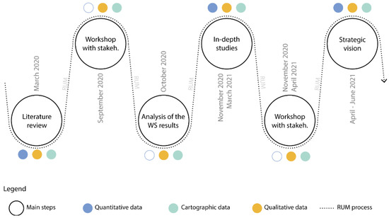
Figure 1.
Rural–Urban Metabolism workflow. Authors’ elaboration, 2022.
- Data collection and management to support the strategic territorial/urban plans;
- Data assessment to critically evaluate the existing context;
- Data mapping to visualize the data and territorial dynamics;
- Definition of the strategic and integrated development plan and actions.
The active participation of local stakeholders is fundamental to achieving the objectives of creating strategic visions and plans. The stakeholders are first mapped, and then, they are analyzed. The Visual Toolbox for System Innovation by Climate-KIC [34] can be used in this stage. This step is strictly connected with the ‘Visioning’ tool, and it is used as an instrument to validate, guide, and support the strategic decisions towards sustainable territory development.
To estimate the inhabitants’ impact on the environment, their Carbon Footprint (CF) has been calculated as an indicator of the overall Ecological Footprint since the carbon-related cycle represents the biggest impact on the ecological footprint [35,36,37]. The assessment of the Ecological Footprint follows a consumption approach that accounts for the amount of resource use that is required to satisfy the consumption of the inhabitants and the corresponding pollution emissions.
The calculation of the inhabitants’ Carbon Footprint is fundamental to identifying the part which have the main impacts on the analyzed territory that will be subsequently mapped to visualize those areas in which action is most needed to implement more sustainable processes. The calculation of biocapacity and the ecological footprint of the territory shows the ecological balance (or unbalance) of the territory, while the qualitative interviews shed light on the economic and social sustainability of certain modes of production and consumption. The Ecological Footprint Analysis (EFA) quantifies and evaluates the Environmental Carrying Capacity (ECC), and it is based on the Material Flow Analysis (MFA) [38]. The EFA estimates the number of natural resources that are required by a city (or a region) for it to function. The Biocapacity (BC) analysis defines the capacity of a territory to renew the resources that are consumed by the people and the processes and its ability to assimilate the waste. By comparing the EFA and the BC of a certain region, it is possible to determine whether the territory is a debtor or a producer of the natural resources. When the Ecological Footprint (EF) is greater than the Biocapacity (BC) is, then the territory is defined as a ‘biocapacity debtor’, thereby indicating that the territory’s consumption of the natural resources and services is greater than the capacity of its ecosystems to supply them [39,40]. On the contrary, when the Ecological Footprint is less than the Biocapacity is, the territory is called a “biocapacity reserve,” meaning that the territory’s availability to generate natural resources and services is greater than the residents’ demand is [39,40].
According to Świąder [36], the CF of the household consumption has been assumed as being composed of CF of Food (Food Consumption and Food Waste); the CF is composed of Housing (Sewage, Water, Garbage, Electricity, and Gas); the CF is composed of Mobility (Public and Private Transports); while the CF is composed of goods and services [36] (Figure 2). These categories have been chosen according to Tukker [41] by considering that food and drink, transport, and housing account for 70–80% of the entire lifecycle impact of the products and Froemelt et al. [42], who calculated that the households’ consumption is responsible for “65% of global greenhouse gas emissions and 50–80% of total land, material, and water use”. Therefore, the estimated categories can be considered to be good indicators of the total emission amount. The data sources are reported in Appendix A.
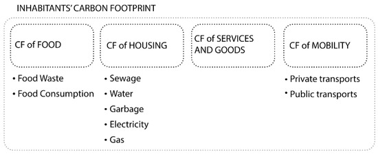
Figure 2.
Categories of data that were collected for the calculation of the inhabitants’ carbon footprint. The method has been proposed by Świąder [36]. Authors’ elaboration, 2022.
The second indicator that has been calculated has been the Biocapacity (BC), which is the capacity of a territory to produce the natural resources. The biocapacity of the Trentino region has been calculated following Świąder [36] by multiplying the physical area by the appropriated Yeld Factor and Equivalence Factor, thereby aiming to obtain the most ecologically productive land uses. To estimate the BC value, it is necessary to divide the territory into homogenous areas that correspond to cropland, forests, or the forest products, grazing land, fishing grounds, built-up land, and the carbon footprint. The remaining areas can be grouped into Non-productive areas. The Global Footprint Network gives a definition for each land use [43].
The Biocapacity has been calculated by multiplying the physical area by the appropriated Yield Factor and Equivalence Factor, thereby aiming to obtain the ecologically productive land uses [36]. The territory has been divided into homogenous areas that correspond to cropland, forests, or forest products, grazing land, fishing grounds, built-up land, and the carbon footprint. The remaining areas can be grouped as Non-productive areas according to Monfreda [43]. This territory’s classification is based on local land use maps or the Corine Land Cover Map. Finally, the biocapacity value has been divided by the number of inhabitants to obtain the per capita biocapacity index.
3.2. Data
The method involved the collection of quantitative, qualitative, and cartographic data. Numerical and cartographic data are fundamental to estimate the resources that are consumed by the inhabitants, and thus, to calculate their ecological footprint on the territory. On the other hand, qualitative data are useful for a deeper knowledge of the territory and for identifying which aspects that it is a priority to act on and with which approach to balance the resources that are used with the resources that are produced by the territory. Finally, maps are the basis for spatializing the resource flows in the territory and for calculating the biocapacity.
According to Świąder [36], a hybrid methodology combining the Top-Down and Bottom-Up data-gathering methods was used to quantify the consumption of the residents. This makes it possible to collect the data with a high degree of precision, while also having a decent chance of comparing the findings to those of the other case studies. The Top-Down methodologies, which use national or regional data to provide aggregate conclusions, are highly standardized techniques that allow for easy comparisons to be made (NUTS3 level). The primary drawback of these approaches is that they occasionally fail to accurately capture the local circumstances. However, because they are more distinctive to the local circumstance, the Bottom-Up techniques are less similar and more representational of the setting. The evaluation of the ecological footprint uses a consumption-based methodology that takes into consideration the resources that are needed to meet the human consumption needs as well as the resulting pollutant emissions. Following Świąder [36], the number of resources that are needed is determined using both the Top-Down and Bottom-Up methods, and in certain situations, a hybrid method combines the two. The Top-Down technique uses regional or national data to provide the aggregate values (which correspond to the NUTS3 level). In the second stage of the RUM methodology, these data are scaled at the urban level. This highly uniform approach guarantees that the findings can be compared to those from other cities or areas. As the statistics are gathered at the national level, the Top-Down method occasionally does not accurately represent the local situation.
Contrarily, the Bottom-Up strategy makes use of the local data by involving the local stakeholders directly and utilizing the information that is supplied by them as well as by the surveys. It more accurately represents the local circumstances, but since it is so closely tied to the setting, its outcomes are scarcely transferable to other regions. A Material Flow Analysis forms the foundation of the accounting approach, which then adapts the steps to the unique requirements of an Ecological Footprint Analysis. A “systematic assessment of flows and stocks of materials within a system specified in location and time” is the manner by which Brunner and Rechberger described the MFA [38]. It is based on the first law of thermodynamics, which states that matter cannot be generated or destroyed. As a result, the sum of the material and energy imports and the locally produced goods which are consumed locally, which result in there being fewer exports, determines the overall quantity of the resources.
The qualitative data were collected during meetings with the local stakeholders and during workshops that were organized during the “SATURN” project. From the dialogue with the technicians, experts, and administrators, it was possible to identify the main criticalities and the opportunities that were offered to develop projects to make the territories that are concerned increasingly circular and more sustainable.
The cartographic data were collected from local databases—which are available on the geo-cartographic portal of the Province of Trento; the national data—these are mainly available on the website of the Italian Institute of Statistics; while the European data—these were used for the Corine Land Cover land use mapping (https://land.copernicus.eu/pan-european/corine-land-cover, accessed on 5 September 2022). The following table (Table 1) shows the Corine land use categories that were present in the Autonomous Province of Trento and their reclassification according to [43].

Table 1.
Land use reclassification in the SATURN project’s areas, 2021. Elaborated from Corine Land Cover (2018) by the authors.
3.3. Objective
The final objective was to develop a comprehensive and flexible tool to guide decision-makers and policymakers in the implementation of multi-functional landscapes. The RUM’s purpose is to improve system thinking and the circularity of the policies to transform the current linear approach to planning into a more circular vision. This is a challenge whose aim is the “transition from a linear perspective to a networked and cyclical perspective, in which wastes become new inputs, reducing dependence on the hinterland for resources” [33]. The conception of the research moved from the observation that the current western lifestyles are no longer sustainable and have significant impacts on the environment. Therefore, having a clear understanding of the balances, or imbalances, between the resource consumption and the capacity of a territory to regenerate them should be the starting point for the territorial strategies, policies, and plans. The Rural–Urban Metabolism is, thus, considered a tool to explore the territory’s dynamics and develop strategic scenarios and plans for a more sustainable future. Moreover, the RUM can be used as an instrument to investigate the relationship between the urban and rural areas and imagine the increasing connections from an ecological and social perspective. To achieve this goal, it is necessary to work at the beginning in a deeper analysis of the territory, and then, on the governance level in accordance with the public administrations and local stakeholders. The RUM supports innovative landscape management through the combination of scientific, quantitative, and analytical approaches with qualitative participatory processes. It can be used to build a shared territorial vision through a set of visioning workshops together with the local stakeholders. Because the RUM is meant to be a tool that can also be used by non-experts, and in context, the approaches that are replicable and scalable have been preferred.
4. Results
As mentioned before, the Trentino Province, an Italian Alpine Region that is located in Northeast Italy, represents the case study in which the Rural–Urban Metabolism tool has been tested.
An analysis of the Carbon Footprint of the inhabitants of the Province of Trento shows that the categories “Transport”, “Services and Goods” and “Food” have the greatest impact in terms of their CO2 equivalent production. Each category has also been investigated from a spatial point of view to visualize the Ecological Footprint as well as to support the policymakers in driving the ecological-based territorial transformation. Indeed, the visualization of the main territorial systems can be useful to visualize and analyze the interconnections between the natural, built, and social systems. There are four layers which have been explored: the green and blue systems; the mobility systems; the touristic systems; the food system.
Transport accounts for 61% of the emissions that are produced, which is equivalent to about 1.53 tCO2eq per citizen. The data were calculated from the average kilometers that were traveled by Italians with private cars, and these were broken down by the category of cars that were registered in Italy (petrol, diesel, hybrid, and electric). The data on the kilometers that were traveled by local public transport were taken from the publicly available local datasets. When comparing the kilometers that were traveled by the private versus the public means of transport, it turns out to be much higher for the former, thereby significantly influencing the total emission output.
A map of the mobility system can be useful to understand the flux of the human activities in the analyzed region. The mobility system can be divided into public and private transport. The heatmap of the bus stops represents the accessibility of the public transport system. Private transport is divided into slow and fast mobility to highlight the different ways of moving into and outside of the territory. It was decided to include the touristic system into the mobility system map to show the flows of the people and resources and their distribution over the territory as this is one of the main economic sectors of the region. If it is connected with the transport map, it is possible to visualize the possibilities of the movement of tourists in the area and thus, deduce their way of moving around and accessing the sites of interest. In the mountain areas, it is particularly interesting to map the ski lifts and ski areas. In Figure 3, we report the layers of the anthropic landscapes map.
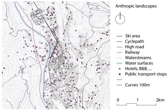
Figure 3.
Map representing the anthropic systems of the Trentino Hub. Authors’ elaboration in the framework of the EIT Climate-KIC SATURN project, 2021.
The category “Services and Goods” includes the calculation of the housing facilities. The data were obtained from the data about the local electricity, water, sewerage and gas utilities and from an estimate of the average consumption of the inhabitants in terms of them purchasing goods and services. This category was found to be responsible for approximately 29% of emissions, which is equivalent to 0.73 tCO2eq.
The third category, in terms of its impact, is related to food consumption and waste, which accounts for 9.3% of the total emissions, or 0.23 tCO2eq. The data on the average amount of food consumption comes from research that was carried out by the Italian CREA Institute on the regions of north-eastern Italy, and they are weighted according to the percentage of the female and male population. The high consumption of animal products, such as meat and dairy products, is the cause of the emissions. The food system map shows the heatmap of food sales and distribution points and the food-productive areas. In this way, it is possible to visualize the food accessibility of the studied region and relate it to other systems, such as the mobility and settlement systems. The addition of specific layers, such as the presence of the organically cultivated areas and a variety of products, makes it possible to observe the levels of support for the biodiversity that is provided by the local agricultural areas. Some areas could hide some critical features from a sustainable point of view: the so-called ”dark side of the green side”. For instance, the crops that are treated with chemicals, pesticides, and fertilizers could have a negative impact on the environment. Therefore, a hierarchy of the green areas based on the sustainability of the different cultivation or management methods could be discussed and proposed. In Figure 4, we report the layers of the food landscapes map.
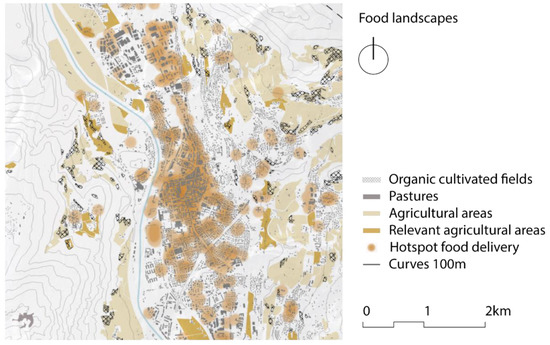
Figure 4.
Map representing the food system of the Trentino Hub. Authors’ elaboration in the framework of the EIT Climate-KIC SATURN project, 2021.
The carbon footprint of Trentino’s inhabitants turns out to be 2.55 tCO2eq, which when rendered in terms of global hectares (gha) for it to be compared with the biocapacity, which equals 2.72 gha. The map in Figure 5 shows the average biocapacity of the Trento case studies according to the different land use classification.
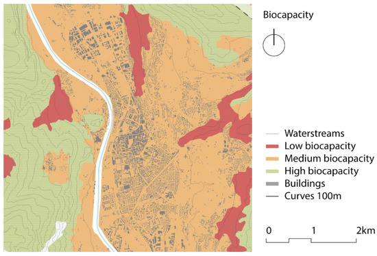
Figure 5.
Map representing the biocapacity of the Trentino Hub. Authors’ elaboration in the framework of the EIT Climate-KIC SATURN project, 2021.
To deepen of the biocapacity analysis, the green and blue systems were elaborated. This map represents the forests, pastures, crops, and urban green areas as parks and gardens. The green systems’ map could be the basis for the analysis of the ecological corridors. A further step that we took was the evaluation of the diverse green systems. The following layers, which were downloaded from the open data catalogues, were added to the map of the Green and Blue system (Figure 6).
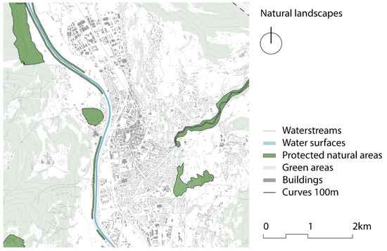
Figure 6.
Map representing the Green and Blue Infrastructures of the Trentino Hub. Authors’ elaboration in the framework of the EIT Climate-KIC SATURN project, 2021.
As mentioned before, the Rural–Urban Metabolism is a territory’s reading tool that aims to analyze the cities and their surroundings from a socio-ecological perspective.
Its final aim is to support the transition of the territorial plans—including both of the urban and rural areas—toward a circular and sustainable future. Therefore, the final step of the RUM process is a report that summarizes, visualizes, and envisions the analysis into the strategic scenarios (Figure 7) that are to be delivered to the local administrations for their further development activities and plans.
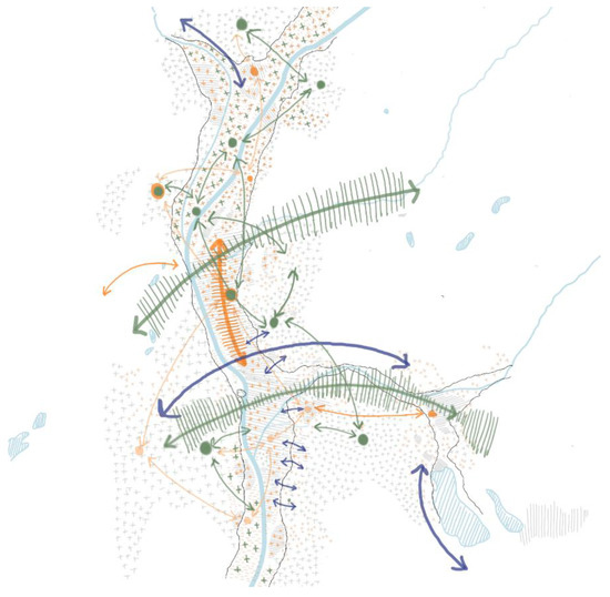
Figure 7.
Results of the internal visioning workshop. Authors’ elaboration in the framework of the EIT Climate-KIC SATURN project, 2021.
To increase the integration of the RUM into the administrative actions, the involvement of a wide range of local stakeholders is needed. The representatives of local associations and NGOs, politicians, public administrators, and representatives of the private sectors can be included in this. The creation of a strong network of actors can support and deepen the analysis of the territory, and this can help to define new possible elements and areas of socio-ecological connectivity. Moreover, a multi-disciplinary and multi-stakeholder approach could be the driver for a better integration of the different perspectives, needs, and opportunities into the final visioning strategic plan and further, promote better relations between the different sectors of public administrations.
In the framework of the SATURN project, the experimental design projects have been developed as testbeds for experimentations at the DICAM-University of Trento through Master’s and Bachelor’s Degree theses, PhD research, and an explorative design in the Landscape Architectural Course, with a final production of 13 Master’s and Bachelor’s theses, two PhD research, and four design experimentations in these courses.
5. Discussion and Final Consideration
The RUM methodological approach has been developed in the Trentino Hub, but it has been designed to be replicable and scalable for other territories to increase the potential for the developed methodology in order for it to be used and for the process to become a part of the planning procedures. To facilitate the replicability of the method by professionals, technical officers, or local administrators, who may not be experts in the Urban Metabolism field, it has been deemed necessary to simplify the model in comparison to other Urban Metabolism examples. This adaptation has led to a decrease in the calculation precision, but as this is not the main aim of the RUM tool, it has been considered to be a necessary change.
The results deriving from different cities and regions could be compared to deepen the understanding of the territorial dynamics. To simplify and speed up the process, the implementation of a GIS plugin is under development. Considering that, at this stage of development, the RUM tool is still a rather long process from a data collection perspective, the automatization of the data elaboration phase could simplify and accelerate the workflow. In particular, the plugin will be related to the ‘Ecological Footprint Analysis’ and the ‘Biocapacity Analysis’, and it will compare the two to determine if the territory could be considered to be a natural reserve or a biocapacity debtor. The plugin could also offer the opportunity to change some territorial features and variables virtually quickly in order to imagine and test different scenarios and compare them, as well as to compare different territories using a common input data set.
Starting from the results that emerged from the calculation of the carbon footprint and the biocapacity and from the mapping of the impacts that they had, through a participatory planning process together with the main local actors, sustainability plans, and strategies have been drawn up. By implementing the EFA and the BC into spatial management, it is possible to improve the planning of long-term natural resource consumption, provision, and regeneration. The Ecological Footprint Analysis, which was compared with the territory’s biocapacity, allows the understanding of the relationship between the natural resource supply and demand. Moreover, it could be a tool that is used to develop the connection between the urban and rural landscapes when it is accompanied by strategic visions and plans to promote the green areas as fundamental resources for the environment and for social well-being. The RUM has appeared to be relevant to policymakers because it divides the complex functioning of the landscape systems into subsystems in order to count the (un)sustainability of each flow. By doing so, it shows the relationship between the subsystems and helps to identify the drivers of the resources’ uses and the pollution emissions, i.e., the impacts of the energy and materials flow on the environment. In doing so, the acquisition of both of the quantitative and qualitative data through a participatory approach has been fundamental to identify the key elements of resource consumption with the help of the stakeholders. This process of the local actors’ involvement has been important also to create interest in the approach and to collect different perspectives toward the design of a masterplan and a list of priorities’ actions for the future territorial development with a more sustainable and circular relationship between the urban and rural areas.
Author Contributions
This paper is to be attributed to the authors A.P., S.F. and M.C., who have collaboratively contributed to its conceptualization, methodology, investigation, and writing. Conceptualization, A.P., S.F. and M.C.; methodology, A.P., S.F. and M.C.; investigation, A.P.; data curation, A.P.; writing—original draft preparation, A.P.; writing—review and editing A.P., S.F. and M.C.; visualization, A.P., S.F. and M.C.; supervision, S.F. and M.C., project administration, M.C. and S.F.; funding acquisition M.C. and S.F. All authors have read and agreed to the published version of the manuscript.
Funding
This research was funded by EIT Climate-KIC under the Climate Innovation Ecosystems 2/2018 grant agreement (Project: “System and sustainable Approach to virTuous interaction of Urban and Rural LaNdscapes”—SATURN) and by the EIT Food-KIC under the Proof-of-Concept program 2021–2022 (Project: “HelpFood 4.0—Food Ecosystem Scalability. Assessing digital and cultural potential of Food Hubs towards sustainable local food systems” CUP: E63C22000820006).
Institutional Review Board Statement
Not applicable.
Informed Consent Statement
Informed consent was obtained from all subjects involved in the study.
Data Availability Statement
Data used in this study are listed in Appendix A.
Acknowledgments
The authors would like to thank all partners and local actors for their generous commitment in the EIT Climate-KIC “SATURN” and EIT Food-KIC “HelpFood 4.0” projects. Special gratitude goes to whole teams of the EIT Climate-KIC “SATURN” project: Alessandro Gretter, Alessandro Betta (Fondazione Edmund Mach, IT); Kathryn Moore, Nick Grayson, Anastasia Nikologianni (Birmingham City University, UK); Marco Ciolli, Sara Favargiotti, Francesca Forno, Angelica Pianegonda, Mattia Andreola (University of Trento); Martin Berg, Anna Ternell, and Martin A. B. Pedersen (City of Göteborg, SWE). Authors thank also the whole team of the EIT Food-KIC “HelpFood 4.0” (https://www.dicam.unitn.it/1745/progetto-helpfood-40, accessed on 5 September 2022) project: Marco Ciolli, Sara Favargiotti (PI), Angelica Pianegonda, Giulia Zantedeschi (University of Trento-DICAM, IT); Matteo Brunelli, Michele Urbani, Francesco Pilati (University of Trento-DII, IT); Giuseppe Caputo, Mirella Collini, Michele Gasparoli, Paolo Vanini (University of Trento, IT); Manuela Bernardi, Luana Bontempo, Francesca Giopp, Alessandro Gretter, Floriana Marin (Fondazione Edmund Mach, IT); Ilaria Carafa, Elisa Morganti, Ilina Petkanovska (Hub Innovazione Trentino, IT); Sara Hernández and Angela Magno (BIOAZUL, SP); Claudia Carocha and Diogo Ramalho (Building Global Innovators, PT); Michela Angeli, Andrea Cappellotto, Cristiano Carlevaro, Giulia Costa, Vadim Cebotari, Mario Conci (Spindox Labs, IT); Martin Berg and Martin A. B. Pedersen (City of Göteborg, SWE); Urszula Ala-Karvia and Silvia Gaiani (University of Helsinki—Ruralia Institute, FI). More information is available on the University of Trento official website.
Conflicts of Interest
The authors declare no conflict of interest.
Appendix A
In this section will be provided data sources utilized for the calculation of the inhabitants’ carbon footprint. All the reported data websites were last accessed on 5 September 2022.
References
- Balk, D.; Pozzi, F.; Yetman, G.; Deichmann, U.; Nelson, A. The Distribution of People and the Dimension of Place: Methodologies to Improve the Global Estimation of Urban Extents. In Proceedings of the International Society for Photogrammetry and Remote Sensing, Proceedings of the Urban Remote Sensing Conference, Enschede, The Netherlands, 12–14 September 2005; pp. 14–16. [Google Scholar]
- Fong, W.K.; Sotos, M.; Doust, M.; Schultz, S.; Marques, A.; Deng-Beck, C. Global Protocol for Community-Scale Greenhouse Gas Inventories: An Accounting and Reporting Standard for Cities, Version 1.1; Greenhouse Gas Protocoll: Washington, DC, USA, 2021. [Google Scholar]
- AMO; Koolhaas, R. Countryside, a Report; Tashen: Köln, Germany, 2020. [Google Scholar]
- Williams, J. Circular Cities. Urban Stud. 2019, 56, 2746–2762. [Google Scholar] [CrossRef]
- Prospects, U. Highlights (ST/ESA/SER. A/423): United Nations, Department of Economic and Social Affairs, Population Division (2019). World Population; United Nations: New York, NY, USA, 2019. [Google Scholar]
- Bahers, J.-B.; Athanassiadis, A.; Perrotti, D.; Kampelmann, S. The Place of Space in Urban Metabolism Research: Towards a Spatial Turn? A Review and Future Agenda. Landsc. Urban Plan. 2022, 221, 104376. [Google Scholar] [CrossRef]
- Nikologianni, A.; Betta, A.; Pianegonda, A.; Favargiotti, S.; Moore, K.; Grayson, N.; Morganti, E.; Berg, M.; Ternell, A.; Ciolli, M.; et al. New Integrated Approaches to Climate Emergency Landscape Strategies: The Case of Pan-European SATURN Project. Sustainability 2020, 12, 8419. [Google Scholar] [CrossRef]
- Favargiotti, S.; Pianegonda, A.; Betta, A.; Andreola, M.; Forno, F.; Ciolli, M.; Gretter, A. Socio-Ecological Connectivity for Productive, Circular and Resilient Territories. The Experience of the “Saturn” EIT Climate-KIC Pan European Project. In Creative Food Cycles-Book 1; Regionales Bauen und Siedlungsplanung, Leibniz Universität Hannover: Hannover, Germany, 2020. [Google Scholar] [CrossRef]
- Wolman, A. The Metabolism of Cities. Sci. Am. 1965, 213, 178–193. [Google Scholar] [CrossRef]
- Cui, X. How Can Cities Support Sustainability: A Bibliometric Analysis of Urban Metabolism. Ecol. Indic. 2018, 93, 704–717. [Google Scholar] [CrossRef]
- Foster, J.B. Marx’s Ecology in Historical Perspective. In Karl Marx; Routledge: London, UK, 2017; pp. 609–621. [Google Scholar]
- Zhang, Y. Urban Metabolism: A Review of Research Methodologies. Environ. Pollut. 2013, 178, 463–473. [Google Scholar] [CrossRef]
- Barles, S. Urban Metabolism of Paris and Its Region. J. Ind. Ecol. 2009, 13, 898–913. [Google Scholar] [CrossRef]
- Kennedy, C.; Pincetl, S.; Bunje, P. The Study of Urban Metabolism and Its Applications to Urban Planning and Design. Environ. Pollut. 2011, 159, 1965–1973. [Google Scholar] [CrossRef]
- Girardet, H. Creating Sustainable Cities; Schumacher Briefings: Cambridge, UK, 1999. [Google Scholar]
- Girardet, H. The Metabolism of Cities. In The Living City; Routledge: London, UK, 2019; pp. 170–180. [Google Scholar]
- Barles, S. Society, Energy and Materials: The Contribution of Urban Metabolism Studies to Sustainable Urban Development Issues. J. Environ. Plan. Manag. 2010, 53, 439–455. [Google Scholar] [CrossRef]
- Thomson, G.; Newman, P. Green Infrastructure and Biophilic Urbanism as Tools for Integrating Resource Efficient and Ecological Cities. Urban Plan. 2021, 6, 75–88. [Google Scholar] [CrossRef]
- Golubiewski, N. Is There a Metabolism of an Urban Ecosystem? An Ecological Critique. AMBIO 2012, 41, 751–764. [Google Scholar] [CrossRef]
- Rhodes, R.A. Governance and Public Administration. Debating Gov. 2000, 54, 90. [Google Scholar]
- Goodman, C.B. Local Government Fragmentation: What Do We Know? State Local Gov. Rev. 2019, 51, 134–144. [Google Scholar] [CrossRef]
- Iommi, S.; Marinari, D.; Iommi, S.; Marinari, D. I Costi Evitabili Della Frammentazione Del Governo Locale in Italia. In Studi e Approfondimenti; IRPET: Firenze, Italy, 2014. [Google Scholar]
- Andreola, M.; Pianegonda, A.; Favargiotti, S.; Forno, F. Urban Food Strategy in the Making: Context, Conventions and Contestations. Agriculture 2021, 11, 177. [Google Scholar] [CrossRef]
- Pianegonda, A.; Frisanco, F.; Betta, A.; Ciolli, M. Multiobjective Analysis of Open Areas Invaded by Forest with Open-Source Software: The Case of the Saturn Project. Int. Arch. Photogramm. Remote Sens. Spat. Inf. Sci. 2022, 48, 4. [Google Scholar] [CrossRef]
- Odum, H.T. Systems Ecology. In An Introduction; Wiley: Minneapolis, MN, USA, 1983. [Google Scholar]
- Voskamp, I.M.; Stremke, S.; Spiller, M.; Perrotti, D.; van der Hoek, J.P.; Rijnaarts, H.H.M. Enhanced Performance of the Eurostat Method for Comprehensive Assessment of Urban Metabolism: A Material Flow Analysis of Amsterdam: Comprehensive Material Flow Analysis of Amsterdam. J. Ind. Ecol. 2017, 21, 887–902. [Google Scholar] [CrossRef]
- Wang, X.; Li, Y.; Liu, N.; Zhang, Y. An Urban Material Flow Analysis Framework and Measurement Method from the Perspective of Urban Metabolism. J. Clean. Prod. 2020, 257, 120564. [Google Scholar] [CrossRef]
- García-Guaita, F.; González-García, S.; Villanueva-Rey, P.; Moreira, M.T.; Feijoo, G. Integrating Urban Metabolism, Material Flow Analysis and Life Cycle Assessment in the Environmental Evaluation of Santiago de Compostela. Sustain. Cities Soc. 2018, 40, 569–580. [Google Scholar] [CrossRef]
- Sastre, S.; Carpintero, Ó.; Lomas, P.L. Regional Material Flow Accounting and Environmental Pressures: The Spanish Case. Environ. Sci. Technol. 2015, 49, 2262–2269. [Google Scholar] [CrossRef]
- Barrett, J.; Vallack, H.; Jones, A.; Haq, G. Material Flow Analysis and Ecological Footprint of New York; Stockholm Environment Institute: Stockholm, Sweden, 2002. [Google Scholar]
- Brunner, P.H.; Rechberger, H. Handbook of Material Flow Analysis; CRC Press: Boca Raton, FL, USA, 2016; ISBN 978-1-315-31344-3. [Google Scholar]
- Hendriks, C.; Obernosterer, R.; Müller, D.; Kytzia, S.; Baccini, P.; Brunner, P.H. Material Flow Analysis: A Tool to Support Environmental Policy Decision Making. Case-Studies on the City of Vienna and the Swiss Lowlands. Local Environ. 2000, 5, 311–328. [Google Scholar] [CrossRef]
- Sanches, T.L.; Bento, N.V.S. Urban Metabolism: A Tool to Accelerate the Transition to a Circular Economy. In Sustainable Cities and Communities; Springer: Cham, Switzerland, 2020; pp. 860–876. [Google Scholar]
- De Vicente, J.; Matti, C. Visual Toolbox for System Innovation. In A Resource Book for Practitioners to Map, Analyse and Facilitate Sustainability Transitions; EIT Climate KIC: Brussels, Belgium, 2016. [Google Scholar]
- Świąder, M.; Szewrański, S.; Kazak, J.K. Environmental Carrying Capacity Assessment—The Policy Instrument and Tool for Sustainable Spatial Management. Front. Environ. Sci. 2020, 8, 579838. [Google Scholar] [CrossRef]
- Świąder, M.; Lin, D.; Szewrański, S.; Kazak, J.K.; Iha, K.; van Hoof, J.; Belčáková, I.; Altiok, S. The Application of Ecological Footprint and Biocapacity for Environmental Carrying Capacity Assessment: A New Approach for European Cities. Environ. Sci. Policy 2020, 105, 56–74. [Google Scholar] [CrossRef]
- Świąder, M. The Implementation of the Concept of Environmental Carrying Capacity into Spatial Management of Cities: A Review. Manag. Environ. Qual. Int. J. 2018, 29, 1059–1074. [Google Scholar] [CrossRef]
- Brunner, P.H.; Rechberger, H. Methodology of MFA. In Practical Handbook of Material Flow Analysis; Lewis Publishers: Boca Raton, FL, USA, 2004; pp. 34–166. [Google Scholar]
- Galli, A.; Iha, K.; Pires, S.M.; Mancini, M.S.; Alves, A.; Zokai, G.; Lin, D.; Murthy, A.; Wackernagel, M. Assessing the Ecological Footprint and Biocapacity of Portuguese Cities: Critical Results for Environmental Awareness and Local Management. Cities 2020, 96, 102442. [Google Scholar] [CrossRef]
- Borucke, M.; Moore, D.; Cranston, G.; Gracey, K.; Iha, K.; Larson, J.; Lazarus, E.; Morales, J.C.; Wackernagel, M.; Galli, A. Accounting for Demand and Supply of the Biosphere’s Regenerative Capacity: The National Footprint Accounts’ Underlying Methodology and Framework. Ecol. Indic. 2013, 24, 518–533. [Google Scholar] [CrossRef]
- Tukker, A.; Jansen, B. Environmental Impacts of Products: A Detailed Review of Studies. J. Ind. Ecol. 2006, 10, 159–182. [Google Scholar] [CrossRef]
- Froemelt, A.; Dürrenmatt, D.J.; Hellweg, S. Using Data Mining to Assess Environmental Impacts of Household Consumption Behaviors. Environ. Sci. Technol. 2018, 52, 8467–8478. [Google Scholar] [CrossRef]
- Monfreda, C.; Wackernagel, M.; Deumling, D. Establishing National Natural Capital Accounts Based on Detailed Ecological Footprint and Biological Capacity Assessments. Land Use Policy 2004, 21, 231–246. [Google Scholar] [CrossRef]
Publisher’s Note: MDPI stays neutral with regard to jurisdictional claims in published maps and institutional affiliations. |
© 2022 by the authors. Licensee MDPI, Basel, Switzerland. This article is an open access article distributed under the terms and conditions of the Creative Commons Attribution (CC BY) license (https://creativecommons.org/licenses/by/4.0/).