Article

Vitality Evaluation of Public Spaces in Historical and Cultural Blocks Based on Multi-Source Data, a Case Study of Suzhou Changmen

School of Architecture and Urban Planning, Suzhou University of Science and Technology, Suzhou 215000, China
*
Authors to whom correspondence should be addressed.
Sustainability 2022, 14(21), 14040; https://doi.org/10.3390/su142114040
Submission received: 29 September 2022 / Revised: 22 October 2022 / Accepted: 25 October 2022 / Published: 28 October 2022
(This article belongs to the Section Sustainable Urban and Rural Development)

Abstract

:
As an intermediate link in the three-level heritage protection system of City–Block–Relic, the historical and cultural block is the most important part. As a component of a city, the vitality of historical and cultural blocks is related to the quality of urban space and the inheritance of cultural memory, and it is of great significance to urban renewal and sustainable development. However, traditional urban vitality evaluation methods need to deal with a large number of complex data, and it is often challenging to take into account the dual characteristics of space and culture. Traditional data and independent analysis strategy cannot not function well anymore. Therefore, this study proposes a vitality evaluation model based on multi-source data, which can account for the dual characteristics of space and culture, carry out dimension-reduced analysis for complex elements, so as to display the vitality image and indicate the key influencing factors of the block vitality. This maybe of important significance for exploring the internal dynamism of historical and cultural blocks. Firstly, guided by the “space-culture” composition of historical and cultural blocks, a wide variety of multi-level complex influencing factors of the vitality can be summed up to establish a three-layer vitality evaluation model. Secondly, the integration of multi-source data is realized by using the digital platform and giving out vitality pictures of the block. In this process, the Changmen historical and cultural block of Suzhou is taken as the sample for empirical research. Finally, the evaluation model is verified by combining the field investigation and the external representation of vitality. The calculation results are compared with the external manifestation of vitality, demonstrating the critical influencing factors of the vitality of public space in historical and cultural blocks, pointing out the direction for the creation of a residential environment and the promotion of vitality in the blocks.

1. Introduction

In the complex and dynamic mega system of the city, historical and cultural blocks, as an organic component of the city, cannot be ignored in the process of urban sustainable development. In the course of urban development, historical and cultural blocks have formed a large amount of accumulation in physical space, social culture and other aspects. If fully explored, they can become an important entry point for vitality and sustainable development. With the idea of sustainable development deeply rooted in people’s hearts, the research and practice of historical and cultural blocks have gradually shifted from simple protection and utilization to sustainable vitality renewal. In the three-level heritage protection system of “city-block-relic” in China, historical and cultural blocks connect the large-scale urban planning and the micro micro-upgrading of urban elements, carrying the urban culture and historical memory. Cultural protection units at all levels, historical buildings, and other urban heritages constitute the style and image of urban characteristics [1]. As the focus of urban construction in China has shifted from expanding space to improving space quality, the renewal of the historical and cultural block has become an essential part of this process [2]. With the arrival of the information age, multi-source data have assisted with the cognition and evaluation, providing a scientific reference for the sustainable development of historical and cultural blocks.

1.1. Characteristics of Historical and Cultural Blocks

The protection concept of historical and cultural heritage in the west began to sprout in the 18th century. Through long-term development, a systematic, scientific and theoretical protection concept has been formed. From the initial protection of individual buildings to the preservation and renewal of the blocks, it now covers the conservation and sustainable development of material and non-material elements. The track of urban development in China is slightly different from that in the west. Since 1982, the concepts of historical and cultural cities, historical districts, historical blocks, and historical and cultural blocks have been formed. The protection of historical and cultural blocks continues to flourish and develop in urban renewal practices, and its concept has become increasingly popular. It is not difficult to sort out the general characteristics of historical and cultural blocks in China from relevant regulations and codes:
  • Real historical relics have authentic historical relics and ensure a certain proportion; for instance, the cultural relics and historic buildings should cover an area of more than 60% of a historical and cultural block [3].
  • Complete historical style and features: the style and features of the block are complete, which can reflect the characteristics of a specific historical period or the characteristics of a particular nationality and region, and has a certain scale of influence, which can be viewed as the history of the whole area.
  • Cultural inheritance: historical and cultural blocks are the carriers of urban culture, such as clouding cultural traditions, lifestyles, customs, social structures, and so on, which gives the block special cultural values.

1.2. Status and Problems of Historical and Cultural Blocks in the Context of Stock Planning in China

As an organic component of cities, historical and cultural blocks face many challenges due to China’s rapid urbanization. Many historical and cultural blocks are disconnected from the newly built urban area to varying degrees, giving out a fractured structure with blurred historical context, and the traditional living atmosphere disappears. It is urgent to explore the original influencing factors of space vitality from the perspective of vitality stimulation, cultural inheritance and sustainable development.
As a kind of living remains of urban culture, the dynamic composition of historical and cultural blocks is complex, dynamic and systematic, showing the co-construction characteristics of space and culture [4]. It is necessary to use scientific methods such as morphological analysis and spatial behavior analysis to study the interactive relationship between people’s will and behavior and the physical space environment in historical and cultural blocks, and to explore the endogenous driving force of the sustainable development of the blocks [5].
As a kind of space resource, historical and cultural blocks have the characteristics of uniqueness, scarcity and vulnerability. They may face many difficulties in the process of upgradation with operation on buildings and structures. However, there are many advantages to vitality stimulation from the public spaces, the carrier of the vitality of the block. Through the vitality evaluation of the public space in the historical and cultural block, it can find the crux of vitality, which may point out the path of the interior renovation of the block. In this process, the comprehensive evaluation based on multi-source data can help the accurate operation of stock updates.

2. Literature Review

2.1. Vitality of Urban Blocks

The concept of vitality originates from biology and ecology, which means the ability to live organisms to maintain survival and development. In A Dictionary of New Terms and Phrases of Contemporary China, vitality is explained as exuberant vitality and the ability to survive and develop. This concept is widely used in different research categories, and there are different representations of specific things. The research on the vitality of the city or block is based on the characteristics of the organic life of the city. It originates from a deep understanding of the complexity, systematization and integrity of the city.
From the cognitive perspective, Jane Jacobs pointed out that the diversity and complexity of cities are the basis of their vitality [6]. She criticized the strangulation of urban vitality by rough urban planning, indicated that the essential influence elements of urban structure can be deeply touched in shared spaces such as streets and explored its complex relationship and interaction mechanism. She also put forward the basic principles of urban vitality construction: functional mixing, small blocks, buildings of different ages and the gathering of people. She believes that the vitality of a city originates from the activities of various users in urban space, which provides a basic framework for evaluating urban vitality. Kevin Lynch put forward five factors that affect the quality of urban space in Good City Form, namely vitality, suitability, feeling, accessibility and management, and defined vitality from an anthropological perspective [7]. For modern urban society, vitality refers to the ability to provide regional vitality and support people’ s activities, and people’s ability to enrich public life. It is suggested that vitality, feeling, suitability, accessibility and management should be taken as important indicators to evaluate the quality of urban spatial form. Ian Bentley believed that vitality is the ability of a place to accept various functions, and pointed out that space with “resonance” and “vitality” not only supports a variety of social activities, but also provides users with a variety of activity choices [8]. His research and practice discussed accessibility, diversity, recognizability, vitality, visual suitability, variousness and individuation. Difei Jiang defined urban vitality as vigorous vitality; that is, the ability of a city to create a humanized existence for its citizens. He pointed out that the agglomeration and activities of people are the driving force for the generation of urban vitality, and emphasized the promotion of social vitality, economic vitality, cultural vitality and sensory vitality in urban development [9]. Li Liu et al. believe that urban vitality is the degree to which a city supports life, economy and ecology, and is an important symbol of urban operation efficiency [10]. Jiwei Lu et al. pointed out that historical and cultural heritage can develop in coordination with urban vitality [11]. These studies explored the essence of urban vitality from different perspectives, recognizing that urban vitality originates from various social activities in urban space, including communication, recreation, rest, etc. However, no systematic path has been formed for specific vitality measurement.
Concerning indicators and construction strategies, Peter Katz et al. pointed out the crucial factors affecting the vitality of urban blocks, such as the mixing of functions, the compactness of layout, the scale suitable for walking and the appropriate construction density [12]. John Montgomery put forward design principles and strategies for improving urban morphology, uprising street life and urban culture, explored the strategies for the pedestrian space mode of European traditional cities and put forward 12 vitality indicators from the aspects of humanized scale, street connectivity, reasonable texture and density, providing some reference for street vitality upgradation [13]. Since the 2000s, many Chinese experts have made in-depth explorations of urban vitality. Jingyuan Jia. et al. proposed using the brightness of night lights to measure the intensity of urban vitality in a large area, and discussed the relationship between vitality and the 3D characteristics of the built environment [14]. Na Ta et al. measured the economic, social and cultural dimensions of urban vitality by using public comment data, taxi data and cultural facilities POI data. They established an econometric model to analyze the impact of the built environment on vitality [15]. These studies indicate that the public space is the carrier of human activities and the foundation of vitality, which determines the urban activities in type, scale, frequency, etc. Additionally, people’s aggregation degree, activity type and occurrence frequency can affect urban vitality. Although the research above has not focused on the category of historical and cultural blocks, it is of enlightening significance to clarify the subject of the vitality research of historical and cultural blocks.

2.2. Vitality of Historical and Cultural Blocks in China

Studies on historical and cultural blocks in China mainly focus on the period after 2000 [16]. Before 2001, the protection of famous historical and cultural cities in China underwent three stages. In the exploration period of the 1980s–1990s, the concept of protection of famous historical and cultural cities was gradually clarified. Although it has not established a complete system, it has proposed key protection objects according to the characteristics of cities. The 1990s–2000s is the formative period, focusing on protection methods. After the 2000s, it entered a deepening period, and the three-level protection system of city–block–relics was gradually completed.
With the deep penetration of the concept of sustainability, more and more scholars have devoted themselves to researching the sustainable development of historical and cultural blocks, and a large number of studies have emerged since then, including the idea of organic renewal of historic cities (proposed by Liangyong Wu), and the idea of the integral continuation of social function structure (Yisan Ruan et al.). In recent years, the rapid development of big data has provided new ideas and innovative ways to research historical and cultural blocks’ vitality.
Ying Long and Yin Zhou used mobile phone signaling data, POI and other data to quantify the vitality of Chengdu, and analyzed the deep-seated reasons for the city’s vitality [17]. Starting from the concept of Aboriginal spatial integration, Ming Lu and Zihan Cai used AHP (analytic hierarchy process) to give out the influencing factors of street spatial vitality, constructed a spatial vitality factor system and applied the evaluation system to Chinese Baroque historical and cultural blocks (Harbin, China), so as to explore the vitality promotion strategy based on aboriginal spatial integration [18]. Tian Lu proposed the “vitality point” concept of historical areas and established a vitality evaluation model based on three aspects: spatial accessibility, functional mixing degree and characteristic culture. He analyzed the historical area of Nanjing Confucius Temple, and finally applied the verification conclusion to the planning of actual cases [19]. Jiajing Li summarized the three elements of the historical area, material, function and people, constructed the evaluation index system of the historical area based on the spatial vitality and carried out the research in combination with case studies in Yaowan historical and cultural block [20]. Hui Liao. et al., aiming to solve the decline of the vitality of historical blocks, analyzed the residential streets with the quantitative analysis system of street space vitality and found out the factors affecting the vitality of the blocks [21]. These studies have carried out systematic research from the two aspects of people and space, but they are still insufficient in the “cultural” characteristics and the vitality related to culture, and they fail to fully utilize the advantages of multiple data to show the vitality of public space in historical and cultural blocks.
Compared with the traditional single-analysis method, the composite evaluation method based on multi-source data proposed in this study simplifies the complex elements in the historical and cultural blocks through quantifiable models. Based on the comprehensive analysis of data from different levels and different sources, the activity characteristics, spatial form, functional layout, cultural resources and other contents of historical and cultural blocks can be delineated by means of spatial syntax and image semantic segmentation tools. Finally, the evaluation results will be loaded into the GIS (Geographic Information System) to show the image of the vitality of the historical and cultural blocks and provide the scientific basis for the targeted renovation of urban historical blocks.

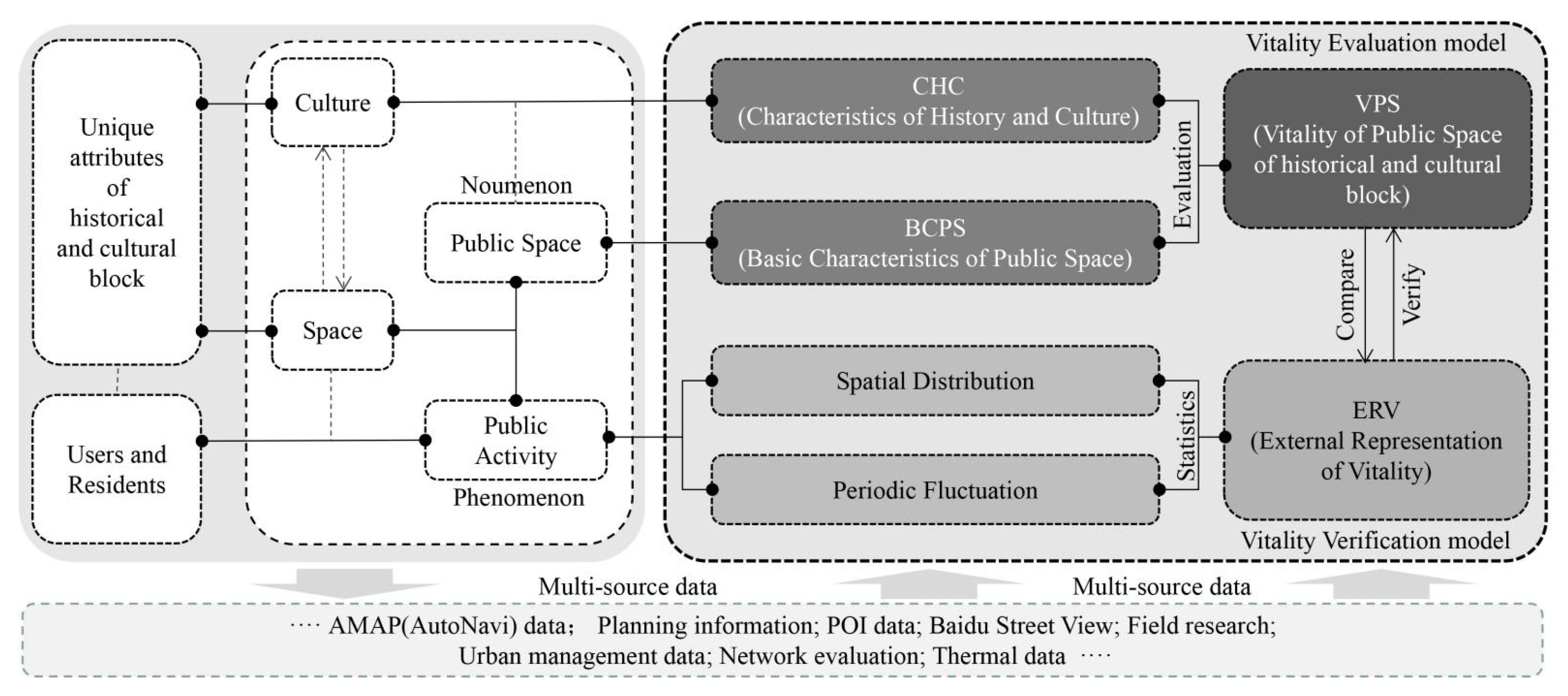
3. Vitality Evaluation Based on Multi-Source Data

3.1. Multi-Source Data

Multi-source data refers to datasets from different sources. In the current information age, they provide favorable data support for the compound analysis and structural exploration of the complex environment of the block. Research methods such as field research and data retrieval (online/offline) can be comprehensively applied to analyze the vitality characteristics of historical and cultural blocks under different spatial and temporal backgrounds, and show the impact mechanism of block vitality on traffic, environment, function and culture. Considering the regional characteristics of historical and cultural blocks, as well as the features of their “space” and “culture”, this study uses the Delphi method, AHP (Analytic Hierarchy Process), and FAHP (fuzzy analytic hierarchy process) comprehensively to establish a multi-level analysis of the vitality [22]. In this way, a vitality evaluation model based on multi-source data can be established, covering the compound elements of space and culture. Data from different channels overlap and improve the accuracy of vitality evaluation. It should be pointed out that, in a multi-level evaluation model, the number of layers is related to the complexity of the problem and the level of detail required to be analyzed. Generally, there are no more than nine elements in each layer. (If there are too many elements in one layer, it will be difficult to compare and judge.)

3.1.1. Multi-Dimensional Coverage

We respect the characteristics of the co-construction of “space” and “culture” of historical and cultural blocks [11,12]. The vitality evaluation should cover the complex and diverse elements of the block. Based on the value composition of historical and cultural blocks and the vitality characteristics of urban public space, the framework of the vitality evaluation is constructed. Additionally, the primary factors affecting vitality can be summed up according to the co-construction of “space” and “culture”. Then, from relevant research on vitality measurement, the common factors affecting the block vitality are screened out through the word frequency screening method, and the indicators of vitality can be formed [21,22,23,24,25]. In the same way, the main influencing factors of vitality evaluation can be further subdivided. These influence factors can be statistically analyzed through different sources and types of data, which have the characteristics of wide coverage and can fully show the complex vitality composition of historical and cultural blocks. (Figure 1, Table 1).

3.1.2. Cross-Correlation

In the evaluation model based on multi-source data, different types of data can be cross-verified and improve the scientific validity of the evaluation [26,27,28]. It comprehensively utilizes spatial syntax calculation, POI (Point of Interest) data, semantic segmentation, planning data and field research. After screening and fusion, the data can be evaluated comprehensively by using the specific Geographic Information System software, ArcGIS. The block’s crowd heat in different periods is adopted as the ERV (External representation of vitality) to verify the evaluation results. In addition, combined with the field investigation, it can improve the scientific validity of the model.

3.1.3. Open Adaptability

Multi-source data sources are extensive, and many data are not limited by time and space, which provides convenience for investigation and research. The network platform has the advantage of open interaction, which helps residents to receive feedback and strengthen public participation [29]. Based on the evaluation framework, it can be expanded by adjusting the screening of influence factors and weight assignment to provide a valuable reference for the accurate updating of historical blocks.

3.2. Vitality Evaluation Model

Given the “space” and “culture” integration of historical and cultural blocks, it establishes a three-layer evaluation model. The target layer contains two categories of BCPS (Basic Characteristics of Public Space) and CHC (Characteristics of History and Culture). The rule layer focuses on the value composition of historical and cultural blocks and the vitality characteristics of public space, and five indicators are selected by using word frequency analysis, combining field research and literature laws and regulations. Using the method of AHP (analytic hierarchy process), 12 main influence factors are selected for the index layer (Table 1). Then, the Delphi method is adopted to weigh every index.

3.2.1. Categories (Target Layer)

As an organic component of a city, public space in the historical and cultural block has not only the general characteristics of urban public area but also some unique characteristics different from other regions and cities. These characteristics can be summarized as architectural styles, forms, cultural traditions, special events, etc., which differ from other areas. Therefore, the vitality characteristics of public space in historical and cultural blocks can be divided into two aspects of BCPS (basic characteristics of public space) and CHC (Characteristics of History and Culture). For one thing, the public space’s historical and cultural characteristics are possessed by the unique situation of the historical and cultural block; for another, the basic characteristics of public space are the common characteristics of urban public space. Therefore, the target layer of the evaluation system is divided into two categories of BCPS (Basic Characteristics of Public Space) and CHC (Characteristics of History and Culture).

3.2.2. Indicators (Rule Layer)

Referring to the Global Public Space Toolkit from Global Principles to Local Policies and Practice [30], which explains the system of public space system evaluation and the evaluation indicators of each key feature, as well as relevant theoretical research results, the five indicators of public space vitality evaluation of historical and cultural blocks are established. The rule layer is subdivided into five indicators, namely accessibility, comfort and functionality, characteristics of material elements, and characteristics of non-material elements.

3.2.3. Main Influence Factors (Index Layer)

The screening of influence factors considers both common elements and specific characteristics. The screening of common factors is mainly conducted through the method of word frequency analysis. According to the relevant research and practice, the factors of spatial, functional and material cultural characteristics are screened. The study carried out the literature search and screening on the theme of “vitality of public space” and “vitality of historic block” from 2015 to 2020 through the CNKI platform, summarized and sorted out the vitality factors involved in the literature and counted the elements with high frequency, representativeness and computability as the influencing factors of the public space vitality of historical and cultural blocks. The specific factors are important ones that distinguish the historical and cultural blocks from other spaces. It is supplemented according to the Standard of conservation planning for historic city (GB/T50357-2018) [3]. In this way, 12 main influence factors can be determined, and the index layer is formed with spatial accessibility, traffic convenience, spatial scale, green visual rate, leisure facilities, cleanliness, functional mixing, functional density, impact scope, authenticity, historical value and cultural experience.

3.2.4. Evaluation Criteria and Weight

Multi-source data can avoid the limitation of single data. Through scientific screening and data fusion on the GIS platform, we can get the vitality image of the block [31,32]. In this process, it is necessary to establish the vitality impact index system and evaluation criteria (Table 1) under the framework of the vitality evaluation and determine the weight of the influencing factors. Through AHP and Delphi Method (40 effective expert questionnaires, mainly for experts and designers in urban planning and architecture-related majors), the vital relationship between factors is compared, and their weights are given (Table 2).

3.3. Characterization and Evaluation Criteria

3.3.1. Accessibility

Accessibility guarantees space use efficiency and the necessary condition for block activities. The accessibility elements of historical and cultural blocks are mainly restricted by spatial features such as street networks and are closely related to the social environment and social activities [19,28,33]. In general, the scale of the traffic network of China’s historical and cultural districts is small and closely related to the public open space. The accessibility of public space in the blocks is jointly affected by the spatial structure and traffic convenience and can be characterized by two factors: spatial accessibility and traffic convenience.
In the vast majority of Chinese cities, the walking system of historical and cultural blocks is quite different from those of modern urban built-up areas. Walking is not only one of the main travel modes of historical and cultural blocks; it is also an important carrier for their vitality and sustainable development. Generally, the main roads are mixed with people and vehicles, connecting the historical and cultural blocks and urban built-up areas (such as Xizhong-shi Road in Changmen Historical and Cultural Block), while the internal streets and alleys mostly serve the internal use of the block, mainly for walking and cycling. Public transport stations and parking facilities are mostly associated with main roads, and public bicycle stations are mostly associated with main streets and alleys, facilitating the transformation of different transport modes. Therefore, traffic convenience is also included in the accessibility evaluation by referring to the Standard of Conservation Planning for Historic City (GB/T50357-2018).
  • Spatial Accessibility
Spatial accessibility refers to the ease of moving from one point to another, which can reflect the convenience of social and economic activities in urban public space and is the foundation of block vitality [34]. Based on AMAP(AutoNavi) data, an axis map of the traffic network can be redrawn in CAD and further calculated by ArcGIS. The spatial accessibility can be judged by the axis model analysis (integration) of Depthmap, which expresses the accessibility of the space graphically. The results are divided into five levels according to the natural discontinuity method, and the spatial accessibility score with the highest degree of integration is “5”.
  • Traffic Convenience
Traffic convenience refers to the accessibility of the public space in the block within the city, which can be measured by the coverage of public transport stations (buses, subways, public bicycles, etc.) and parking lots data. First, the study collects POI data of public transport stations such as buses, subways and public bicycles from the website. Then, using ArcGIS, the data are implanted into the block plan for kernel density estimate, representing the traffic convenience of space graphically. Finally, the results are divided into five levels according to the natural discontinuity method, and the traffic accessibility score with the highest density of public transport facilities is “5”.

3.3.2. Comfort

Comfort is the key factor in enhancing the vitality of street space, meeting the psychological and physiological needs of users, and ensuring the comfort of space to maintain a certain frequency of human activities. Comfort can be characterized by spatial scale, green view ratio, rest/recreational and sanitary facilities [35,36].
  • Spatial Scale
An excellent spatial scale of a public space can enhance people’s willingness to stay in a certain area and encourage various social communications. The spatial scale can be quantified by the D/H Value (D is the width of the street or spatial section, and H is the height of buildings or spatial enclosure interface). According to the research of Ashihara Yoshinobu, when the D/H reaches 1.5–2.0, the space perception is comfortable for users [37]. In this study, the D/H Value of the units can be divided into five levels. Refer to Table 3 for the scoring criteria.
  • Green View Ratio
The green view ratio refers to the proportion of green plants in people’s vision. The evaluation focuses on the three-dimensional structure of greening, which changes with time and space. A high green-view ratio will bring visual and psychological comfort to the crowd, making the masses more willing to stay [38]. It can be quantified by using Semantic Image Segmentation, which is an important branch in the field of AI. It can be used for street scene image recognition and calculating the green-view ratio. By classifying the pixel points of the image, the category of each point (such as belonging to the background, people or vehicles) is determined to divide the area. The results of the green view ratio is divided into five levels, and the public space with the highest green-view ratio is scored as “5”.
  • Rest/Recreational Facilities
The satisfaction degree of rest/recreational facilities is of great significance, encouraging the crowd to gather and stimulate communication activities. Due to the characteristics of the linear layout of rest/recreational facilities, the full-length information can be used for calculation. Then, the statistical results are divided into five levels. Refer to Table 3 for the scoring criteria.
  • Sanitary Facilities
Sanitary facilities greatly impact public spaces, and are a basic condition for people to stay in the space. It can be quantified by referring to the environmental evaluation standards of urban public space and relevant regulations. See Table 3 for scoring criteria.

3.3.3. Functionality

Functionality reflects the satisfaction of public space with the needs of different users, and can represent the diversity and richness of activities [39,40]. The sufficiency of available services and the diversity of place types guarantee vitality. Functionality can be characterized by mixedness, functional density and impact.
  • Mixedness
Functional mixedness refers to the degree of diversity of public space functions, which can bring a variety of general activities. The combination of open source data and field investigation can be used to collect the operational POI data of the block. Then, the POI data can be loaded into GIS for sorting and counting. In this study, the functions can be divided into four categories (retail, catering, sightseeing and service) and 14 subcategories. Then, the results are divided into five levels according to the natural discontinuity method. In this study, mixedness with the highest functional category is scored as “5”.
  • Density
Function density refers to the density of the functions of the public space itself and the surroundings, which can be calculated by the ratio of the number of POI to the area of the public space.
F_Density = F_num/Area(i), (i = 1, 2, 3, …, n)*
*F_Density represents the functional density of public space, F_Num represents the total number of functions in the space and Area(i) represents the area of the ith space unit. The statistical results are divided into five levels according to the natural discontinuity method, and the spatial mixing degree with the highest functional category is scored as “5”.
  • Impact
Impact refers to the radiation range of the function, which can generally be measured by the service radius of the function, the particularity of the function and the attraction of the function. If functions with different influence ranges are in the same unit, the process with the most significant influence is selected and scored. See Table 3 for the scoring criteria.

3.3.4. Characteristics of Material Elements

The historical value and standard features of buildings in historical and cultural blocks are important factors related to space attraction [41,42]. The CME (Characteristics of Material Elements) focuses on the characteristics of buildings, facilities, structures, landscapes and other material aspects in the block. It can be characterized by historical value and authenticity.
  • Historical Value
Historical value usually refers to the building enclosing the relevant public space, which includes two attributes: the building (including the relevant public space) construction age and its cultural value. The judgment of the historical value is mainly based on the buildings’ age, style and protection level. Regarding the current classification of protection levels of historical relics, the investigation objects are divided into five classes.
  • Authenticity
Authenticity is a standard used to measure whether the constituent elements of a block are in harmony with the surrounding environment, or whether they conform to the state at the time of initial construction [43,44]. It includes two aspects: whether the overall structure of the constituent elements has changed; and whether the surrounding environment, such as the decoration, layout and courtyard state of the internal structures or buildings in the public space, are harmonious with the surrounding environment. The latter needs to be evaluated regarding whether the overall design of the building/structure and other constituent elements has changed and whether the decoration, layout and courtyard state environment of the facilities or buildings in the public space are harmonious with their surroundings.
In China, the evaluation of historical value and authenticity is generally conducted by the expert team in combination with historical structural stability, insight, preservation conditions and other contents. Therefore, this study refers to the current management methods, invites experts in this field institute to provide scores, and summarizes their evaluation criteria. Concerning Article 4 of Administrative Measures for the Protection and Utilization of Historical Buildings in Suzhou (SFGZ [2021] No. 12) [45], five experts from the Suzhou National Institute for the Protection of Historic and Cultural Cities were invited to conduct a comprehensive evaluation of the authenticity of each unit from the perspectives of structural integrity and style coordination. See Table 3 for summarized evaluation criteria.

3.3.5. Characteristics of Non-Material Elements

The CNE (Characteristics of Non-material Elements) refer to the functions attached to buildings, facilities and places, as well as related tools, handicrafts, knowledge, skills, etc. These elements are continuously inherited in the block, giving the coalition a sense of place and identity [16,41]. The CNE (Characteristics of Non-material Element) can be represented by cultural experience factors.
The cultural experience focuses on the richness of cultural elements in historical and cultural blocks. For the Local Chronicles, such as Annals of Jinchang District [46] and other documents, the non-material cultural elements of the block can be marked. Its perception, experience and inheritance can be evaluated based on the data from review website and the results of field survey are considered comprehensively. See Table 3 for summarized evaluation criteria.

4. Empirical Application: Evaluation of the Vitality of Public Space in Changmen Historical and Cultural Block

4.1. Sample Block Overview and Evaluation Unit

As one of the first 24 cities selected as the National Historical and Cultural City, Suzhou is known as “paradise on earth” and has a large number of historical and cultural blocks. According to the Special Plan for the Protection of Suzhou Historical and Cultural City (2035), it will “protect 5 historical and cultural blocks of Pingjiang, Humble Administrator’s Garden, Yiyuan, Changmen and Shantang, and newly designated two historical and cultural blocks of Wu30 Road and River Guantaiwei-Tianci villa, integrate and optimize the designation of 26 historical sections.” [47]. Among them, Changmen Historical and Cultural Block, as the real carrier of market life, reflects the real social and cultural life of traditional Jiangnan cities and is known as the “window of Suzhou”. Therefore, this study selects the research sample of Changmen historical and cultural block.

4.1.1. Sample Block

Suzhou Changmen historical and cultural block is located northwest of the ancient city area, adjacent to Changmen Gate, the west gate of Gusu ancient city (the predecessor of Suzhou City). It is divided into the seventh neighborhood on the north side and the 15th neighborhood on the south side by Xizhong-shi Road, with a total area of 56.62 hectares. The land use status is mainly commercial and residential, with a mixed distribution of cultural relics and historic sites, green space and public squares, etc.
Since the Spring and Autumn Period (770–476 BC), local ancestors gradually formed a settlement near the Changmen area. During the Ming and Qing Dynasties, the Changmen area became the most prosperous area in Suzhou and in the entire country due to its advantages in land and water transportation. After the founding of the People’s Republic of China, Suzhou went through multiple rounds of planning and construction, and its urban scale has gradually expanded. However, the old urban area of Suzhou has maintained its original pattern, and the original texture and architecture have been well preserved. The People’s Government of Jiangsu Province approved the naming of the first batch of Jiangsu historical and cultural blocks on 29 January 2016, and five Suzhou historical and cultural blocks, including Changmen historical and cultural block, were selected. The Changmen Gate was first built in the Spring and Autumn Period and is one of the eight gates of Suzhou City. In the Southern Song Dynasty, the Changmen Gate was demolished until the end of the Yuan Dynasty. At that time, the Changmen Gate was built with a barbican city, which was divided into the Road Gate and the Water Gate. The Jinmen Gate was built in 1922, which means the concentration of wealth and implies the prosperity of the region. In the 1990s, the municipal government invested to renovate the Yipu and Wufeng Garden in Changmen historical and cultural block. Since 2016, Suzhou has carried out an extensive renovation of Changmen historical and cultural block, and rebuilt the North Wharf. The old buildings along Nanxin Road on the southwest were demolished, and based on the continuation of the Soviet-style architectural style, some green spaces and gardens were restored [48] (Figure 2).
There are rich cultural heritages in the block, with both a market atmosphere and a humanistic atmosphere, but there is still a gap between the block and the modern city (Figure 2 and Figure 3). On the one hand, there are numerous traffic problems in the streets and lanes, and the leisure service facilities are insufficient. On the other hand, despite the scattered distribution of historical and cultural resources, some cultural resources have been neglected or abandoned. All kinds of signs show a lack of independent renewal power within the block, and a scientific method is required to guide the renewal process.

4.1.2. Evaluation Unit

Referring to the Global Public Space Toolkit from Global Principles to Local Policies and Practice [30], the public space of historical and cultural blocks can be divided into three categories: traffic space (V1), public open space (V2) and public infrastructure (V3). According to the characteristics of the street composition, the evaluation unit is further subdivided into 177 evaluation units to provide a basis for the subsequent mapping of vitality in space (Figure 4). Among them, the scope of open space and public infrastructure are clear, and each can be used as an independent research unit. However, in the traffic space (V1), the lengths of roads, streets and lanes are different. Determining the evaluation unit according to the natural traffic network may lead to serious deviation. Thus, it is necessary to divide them into small units with a length of 50–100 m, referring to the common scale of blocks. In the specific division, for roads/streets with a length of more than 100 m, the roads/streets are divided into several shorter units with the intersection as the node, and the length of each unit is controlled within 50–100 m. If the two intersections are close, the road/street between the intersections shall be merged into the shorter part. If there is no intersection in the road/street or the intersection spacing is more than 100 m, the road/street shall be divided into several units within 50–100 m based on the building boundary.

4.2. Indicators of Vitality Evaluation of the Sample Block

4.2.1. Accessibility

In general, the accessibility score of the block is good, with most of the units reaching four and above. The overall score of the 15th neighborhood is higher than that of the 7th neighborhood, decreasing from the external urban roads to the internal streets/lanes. Among them, the most accessible units are concentrated in Xizhong-shi Road (A1–A7), Jingde Road, and Jinmen Road (A8–A17) and the surrounding space, and most of the units are near urban arterial roads. The surrounding traffic facilities of these units are abundant, and the spatial integration is high. The areas scored in the middle include urban branches such as Nanxin Street and Wuqufang Street. The main lanes in the 15th neighborhood and some lanes on the south side of the 7th neighborhood have a high degree of integration, but the surrounding traffic facilities are sparse. The spaces with the lowest scores are in the interior of the seventh neighborhood (C24, C25, and C28) and the north side of the North Wharf (B1, H3, and H5). These spaces lack transportation facilities, and the spatial syntax integration is low. Nevertheless, it was found in the field survey that random parking everywhere in the block, occupying public spaces, resulted in the loss of public spirit, which exacerbated the vitality decline of the block to a certain extent (Figure 4).

4.2.2. Comfort

The overall comfort score of the sample block is good. The comfort of the public space along the moat on the west side of the block (B5-B10) is generally high (Comfort ≥ 4). The public buildings (I1, I2), small amusement parks (F7) and square (E1) in the block have high scores for space comfort, with appropriate scale, green spaces and recreational facilities. However, the comfort value of most lanes is generally about three. The poor comfort scored units (Comfort ≤ 1.8) are mostly secondary lanes (C6, C7, C32, etc.), which are narrow in scale and only for traffic, lacking greening and leisure service facilities (low green view ratio and lack leisure facilities) (Figure 5).

4.2.3. Functionality

The overall functionality score distribution of the block is uneven, with urban roads higher than internal streets and lanes. The average score of the 15th neighborhood is higher than that of the 7th neighborhood. The functional evaluation of urban roads with commercial shops on both sides is high: both sides of Xizhong-shi Road are dominated by traditional restaurants and supermarkets, and there are some large hotels as well. Wuqufang Street and Tangjia Lane mainly serve the residents of the block, and the business is mainly related to diet. Jingde Road and Jinmen Road are dominated by clothing, luggage and service industries. The functional evaluation of the streets and alleys in the block is general: there are some mahjong shops, canteens, barbers and other commercial points scattered in the 15th neighborhood, and the functionality in the 7th neighborhood is low, lacking commercial and service for the surrounding residents (Figure 5).

4.2.4. Characteristics of Material Element

The overall CME score is high, and the recognition degree of historical characteristics of material elements is high. Among them, the buildings along Xizhong-shi Road are all in the style of the Republic of China and are in good condition (CME > 4.2). The internal units of the block, such as Taibo Temple, Wufeng Garden and Yipu Garden are in good condition after renovation (CME = 5). Other historical buildings along small lanes (such as C49 and C75) are in poor condition (CME ≈ 3). The buildings around Jingde Road, Nanxin Road, North Wharf and other urban roads are all modern buildings with low authenticity and historical value (CME ≤ 1.8) (Figure 6).

4.2.5. Characteristics of Non-Material Element

The cultural experience score of intangible culture in public space is generally low, except for some important nodes, such as Art Garden (I1) and Wufeng Garden (I2), which have interactive experience modes. Despite those units, few buildings and structures with historical and cultural values have diversified display modes, most of them lacking cultural experience and interaction (Figure 6).

4.3. Comprehensive Evaluation and External Representation of Vitality

4.3.1. Comprehensive Evaluation of Vitality

The overall evaluation gradient is extensive, with the highest VPS score of 3.99, the lowest VPS score of 1.51 and the average VPS score of 2.52. Specifically, in a large number of evaluation units of the sample block, only a small number of public space units gain high scores, and the vast majority of units are rated as average or poor. Among them, 9 units (5.1%) scored above 3.4, while 69 units with scores of 2.6–3.4 accounted for 40.0% (Figure 7).
Regarding spatial distribution, the units scored above 3.4 are concentrated in Xichong-shi Road and the space near the ancient gate Changmen. The units that scored more than 2.6 are mainly distributed in the public space around the 15th neighborhood and along the inner main lanes. The southern routes of the 7th neighborhood, Taibo Temple, Wufeng Garden and other nodes also obtained high scores. Despite these, the internal units of the 7th and the 15th neighborhoods are primarily below 2.6.
Among the traffic space units, the main roads, secondary roads, streets, squares and small gardens scored high (VPS ≥ 2.6). Among the divisions of public facilities, ancestral temples and gardens have high scores (VPS ≥ 2.6). Most of these units have a relatively comfortable spatial scale or some prominent advantage in terms of accessibility, functionality or CHC (Characteristics of History and Culture). However, the scores of lanes and alleys, bridgehead spaces, public open spaces and green spaces along the river get low VPS scores generally, which are scored low in spatial scale, functionality and accessibility. Among them, some units evaluated high in CHC (Characteristics of History and Culture) lack cultural experience, causing low space attractiveness.

4.3.2. External Representation of Vitality (Verification)

The heatmap reflects the population distribution and density in a specific time and space and can be used as a quantitative basis for the external representation of vitality. To facilitate the analysis and processing of the data, the thermal value is divided into several levels according to the same standard. The higher the level, the higher the thermal value, and the larger the relative population density of the space is, and vice versa. The thermal data in different periods show the tidal thermal fluctuation of the block (Figure 8). In this study, in order to reduce interference of some necessary activities (tidal fluctuations on weekdays, such as work, residence, study, etc.) on the vitality measurement of the block, the average thermal value of 14:00–18:00 on nonworking days is selected. Then, the data are imported into ArcGIS to calculate the average heat value and express it graphically as a quantitative basis for the ERV (External Representation of Vitality). The evaluation results are classified into three levels: 0–1.5 (excluding 0.15.) is low, 1.5–3 (excluding 3) is medium and ≥ 3 is high (Figure 9).
Through comparison, it is found that the thermal gradient distribution of the sample block and the viability evaluation value gradient shows a high coincidence in space (Figure 7 and Figure 9). In the overall evaluation, there are more high vitality spaces in the sample blocks. The evaluation units with an ERV score of 1.5 or above accounted for 66.7% (118), and those with an ERV score of less than 1.5 accounted for 33.3% (59). The spatial distribution of the ERV score of the sample block shows the following characteristics: the outer part is higher than the inner part, and the space with the most elevated vitality is concentrated in the middle part of Xizhong-shi Road. The vitality on the east side of Jingde Road, and the surrounding expanses of Nanxin Road, Wuqufang Street, Tangjiaxiang street and Neixiatanga Street, is slightly lower. The ERV score at the nodes of main lanes and urban roads is high, but the overall ERV score within the block shows a precipitous decline, such as inner lanes of the 7th neighborhood, and inner lanes in the north of the 15th neighborhood.
The results of VPS (Vitality of Public Space of the historical and cultural block) and ERV (External Representation of Vitality) are consistent in vitality gradient and distribution, indicating that the vitality evaluation model proposed in this study has a certain degree of reliability.

5. Discussion

5.1. Discussion on the Correlation between Evaluation and Representation

The correlation between the vitality evaluation and the representation of vitality phenomena can be studied by comparing the evaluation results of VPS (Vitality of Public Space of the historical and cultural block), BCPS (Basic Characteristics of Public Space), and CHC (Characteristics of History and Culture) with ERV (External Representation of Vitality), and the correlation between the indicators can be shown by the R2 (the coefficient of determination) (Figure 10). There was an obvious linear relationship between VPS and ERV (R2 = 0.41). The coefficient of determination of BCPS and ERV of the categories of vitality evaluation is high (R2 = 0.4761). The scatter diagram of CHC and ERV is dispersed. It shows that the BCPS plays a major role in the vitality of the sample block.

5.2. Vitality Promotion Strategy Based on Evaluation

The comparison of vitality evaluation and ERV (External Representation of Vitality) shows the elements at different levels of the vitality of the block. The score of each sub-item can provide a reference direction for the improvement of the vitality of historical and cultural blocks. According to the evaluation of Changmen Historical and Cultural blocks, the vitality of the block can be improved from the following two aspects.

5.2.1. Improve Path According to the Basic Characteristics of Public Space

The BCPS (Basic Characteristics of Public Space) and ERV (External Representation of Vitality) are highly correlated, and the improvement of the former can promote the latter. Optimizing the components of the former (five indicators) is feasible in order to achieve vitality improvement.
First of all, to improve accessibility, the crux of spatial accessibility can be quantitatively analyzed in combination with the specific transport system. Public transport stations can be added at some weak points, and multiple modes of transportation are used to overlap each other to improve spatial accessibility. Secondly, for the improvement of comfort, it is necessary to improve the quantity and quality of physical space in the block, balance the distribution and coverage of service facilities and create diverse spatial boundaries of blocks. The construction and renovation of spatial nodes should meet the needs of both residents and tourists, and the construction activities should consider the ancient trees and landscape to strengthen the regional attribute. Finally, aiming for upgraded functionality, the existing functions of the block shall be integrated, and appropriate functions shall be introduced to promote diversification and enhance the functional experience. In addition, the diversified construction of functions needs to consider the functional penetration and integration of “city-block-building”, and block functions can be adjusted according to people’s different needs.

5.2.2. Improve Path According to the Characteristics of History and Culture

Although the correlation between CHC (Characteristics of History and Culture) and ERV (External Representation of Vitality) is not significant, a comfortable public space full of culture and history is of great significance to the sustainable development of the block.
For some intangible cultural heritages, creative workshops can be implanted in combination with repairing and protecting historical buildings. It can display the characteristic regional skills in historical buildings and promote the inheritance of regional culture. For some existing or disappearing folk activities, corresponding festival tours and theme tours can be set up in combination with tourism activities to improve participation in the cultural experience. Some historical figures and cultural legends can be displayed in existing cultural buildings or reproduced in the form of road signs, statues and dynamic images.

6. Conclusions

With the protection of historical and cultural blocks reaching a certain depth, the promotion of the vitality of historical and cultural blocks becomes an important means to promote their sustainable development. Clarifying the influencing factors is the basis for promoting the vitality of historical blocks. Scientific evaluation methods can help us to find the vitality crux of the historical and cultural blocks, so as to guide the sustainable development of the blocks in space and culture through targeted adjustment. This study proposes a method for evaluating the vitality of public space in historical and cultural blocks based on multi-source data, which overcomes the shortcomings of traditional evaluation methods in data acquisition and comprehensive evaluation. It is of great significance to explore the inner vitality of the historical and cultural blocks and points out the direction for the construction and vitality improvement of the residential environment of the blocks.
Historical and cultural blocks are important heritages in urban interior renewal. Their protection and vitality renewal have potency in the aspects of space and society that cannot be ignored for the continuation of cultural context and the reappearance of urban memory. A scientific and reasonable vitality evaluation system can give play to the advantages of multi-source data for comprehensive evaluation. Data from different sources, forms and structures can be fused and analyzed through systematic analysis. It reveals the hidden relationship between the vitality influencing factors in the historical and cultural blocks, to provide scientific reference for revitalizing historical and cultural blocks.
The multi-source data themselves contain a multi-dimensional perspective. The evaluation based on the multi-source data can reflect the complex characteristics of the block more widely than the traditional planning data, and even the primary users’/specific groups’ understanding of the spatial characteristics and cultural connotation of the historical and cultural block. This makes our description of historical and cultural blocks go beyond the simple physical space and independent cultural heritages and go deep into the interaction between space and user behavior. Although these phenomena are not necessarily found based on the multi-source data, the digital images overlapping can show the correlation between the vitality phenomenon and the influencing factors and help to find the mechanism behind the vitality phenomenon. In addition, the comprehensive application of multiple data types can also be cross verified to strengthen our understanding of vitality.
The comprehensive vitality analysis of digitization and visualization has predictive advantages for renewing historical and cultural blocks and is convenient for operation and practice. The evaluation model correlates the vitality representation with the spatial characteristics, which helps to find the spatial crux under the vitality representation and provides a basic structure for the functional localization in the renovation. For example, analysis of the essential characteristics of public space, spatial syntax and ArcGIS is used for quantitative description, showing the interactive relationship between “spatial characteristics” and “human behavior”, and the role of different influencing factors in the spatial form. Based on this, the implementation effect of the renovation and renewal design scheme can be predicted.
However, it should be pointed out that the influence factors of the vitality of public space in historical and cultural blocks are not static and show certain characteristics in different regions. In this study, the impact factors are divided into general impact factors and specific ones. The former is the universal impact factor of the vitality of the public space of the block, and the latter is the targeted impact factor proposed for the historical and cultural block. Therefore, based on the model this study has given, some relevant evaluation models for particular blocks can be formed by adjusting the type and quantity of impact factors (primarily targeted distinguishing factors) and the weight of impact factors at all levels according to the characteristics of the project. In addition, in the empirical study, it is found that new data sources such as open source data or big data cannot replace traditional research. For example, in the study of social aggregation, it is difficult to restore the trajectory of individuals in the street in a short time based on big data, such as thermal information of mobile phone signaling. Additionally, data sources such as shared bikes and taxis are often focused on a specific vehicle. Therefore, field research is still an effective method for obtaining supplementary data.

Author Contributions

F.Z. contributed to the development of the idea and participated in all phases. Q.L. and X.Z. helped perform the analysis with constructive discussion. All authors have read and agreed to the published version of the manuscript.

Funding

This research was supported by a grant from the National Natural Science Foundation of China (Multivariable Analysis Method and Evaluation of Exterior Spatial Multi-Element in Urban Small Blocks Reconsitution from a Digital View, Grant No. 51808365), and Postgraduate curriculum reform project of Suzhou University of Science and Technology (Architecture and Urban Design II, Grant No. 21SZKC-01).

Institutional Review Board Statement

The study was conducted in accordance with the Declaration of Helsinki, and approved by the Ethics Committee of Suzhou University of Science and Technology (protocol code 20220320, on 20 March 2022).

Informed Consent Statement

Informed consent was obtained from all subjects involved in the study.

Data Availability Statement

The data used to support the findings of this study are available from the corresponding author upon request.

Acknowledgments

The authors acknowledge the support from the Key Disciplines of the Fourteenth Five Year Project of Jiangsu Province (Architecture), China. The authors would like to thank Ruofei Xu for her valuable support for editing, and Qing Shen, Yong Yin for providing photos of Wufeng garden and Yipu garden.

Conflicts of Interest

The authors declare no conflict of interest.

References

  1. Zhang, Y.; Yang, C.; Jia, Z. The enlightenment of “historical dynamics” to the space restoration of historical blocks. Archit. J. 2018, S1, 161–167. [Google Scholar]
  2. Yong, H.; Sun, Y. Review on Historical District Preservation and Renovation Practice. Planners 2015, 31, 98–104. [Google Scholar]
  3. GB/T50357-2018; Standard of Conservation Planning for Historic City. Ministry of Housing and Urban-Rural Development of the People’s Republic of China: Beijing, China, 2019.
  4. Reid, E.; Otto, C. Measuring Urban Design: Metrics for Livable Places; Island Press: Washington, DC, USA, 2013. [Google Scholar]
  5. UNESCO. Recommendation on the Historic Urban Landscape; UNESCO World Heritage Center: Paris, France, 2011. [Google Scholar]
  6. Jane, J. The Death and Life of Great American Cities; Vintage: New York, NY, USA, 1961; pp. 56–134. [Google Scholar]
  7. Kevin, L. Good City Form; The MIT Press: Cambridge, MA, USA, 1984. [Google Scholar]
  8. Ian, B. Urban Transformations: Power, People and Urban Design; Routledge: London, UK, 1999. [Google Scholar]
  9. Jiang, D. The Theory of City Form Vitality; South-East University Press: Nanjing, China, 2007. [Google Scholar]
  10. Liu, L.; Xu, Y.; Jiang, S.; Wu, Q. Evaluation of urban vitality based on fuzzy object element model. Geogr. Geogr. Inf. Sci. 2010, 26, 73–77. [Google Scholar]
  11. Lv, J.; Zhang, F. Coordinated develop-ment of historical inheri.tance and the city’s vitality. New Archit. 2016, 1, 32–36. [Google Scholar]
  12. Peter, K. The New Urbanism: Towards an Architecture of Community; MC Raw Hill: New York, NY, USA, 1994; pp. 23–47. [Google Scholar]
  13. John, M. Making a City: Urbanity, Vitality and Urban Design. J. Urban Des. 1998, 3, 93–116. [Google Scholar]
  14. Jin, J.; Song, J. Identifying the Relationship between Urban Vitality and the 3D Characteristics of Built Environment: A Case Study of Wuhan, China. Mod. Urban Res. 2020, 8, 59–66. [Google Scholar]
  15. Ta, N.; Zeng, Y.; Zhu, Q.; Wu, J. Relationship Between Built Environment and Urban Vitality in Shanghai Downtown Area Based on Big Data. Sci. Geogr. Sin. 2020, 40, 60–68. [Google Scholar] [CrossRef]
  16. Zhao, Y.; Liu, J.; Zheng, Y. Preservation and Renewal: A Study on Visual Evaluation of Urban Historical and Cultural Street Landscape in Quanzhou. Sustainability 2022, 14, 8775. [Google Scholar] [CrossRef]
  17. Ying, L.; Yin, Z. Quantitative Evaluation on Street Vibrancy and Its Impact Factors: A Case Study of Chengdu. New Archit. 2016, 1, 52–57. [Google Scholar] [CrossRef]
  18. Ming, L.; Chen, Z. Vitality Upgrade for Historical and Cultural Blocks Based on Inhabitant Spatial Integration. Planners 2017, 33, 17–23. [Google Scholar]
  19. Tian, L. Functional and Spatial Revival in Historic Area from the Perspective of Raising Vitality. Master’s Thesis, Southeast University, Nanjing, China, 2016. [Google Scholar]
  20. Li, J. Research for the Historic Area Conservation based on Development Vitality. Master’s Thesis, Southeast University, Nanjing, China, 2015. [Google Scholar]
  21. Liao, H.; Feng, W.; Zhao, J. Quantitative Evaluation and Improvement Strategies Exploration of the Vigor of Residential Historical and Cultural Streets and Communities. Shanghai Urban Manag. 2017, 26, 75–78. [Google Scholar] [CrossRef]
  22. Chen, Y. Social Impact Assessment on The Conservation of Residential Historic Districts. Ph.D. Thesis, Southeast University, Nanjing, China, 2020. [Google Scholar]
  23. Wang, X. Research on Heritage Conservation based on Local Community in the Context of Inner-city Redevelopment: Case Study of Tianjin. Ph.D. Thesis, Tianjin University, Tianjin, China, 2020. [Google Scholar]
  24. Zhang, Y.; Yang, C.; Ling, Q. Study on the Assessment of Street Vitality and Influencing Factors in the Historic District—A Case Study of Shichahai Historic District. Chin. Landsc. Archit. 2019, 35, 106–111. [Google Scholar]
  25. Guerra de Oliveira, S.; Biancardo, S.A.; Tibaut, A. Optimizing H-BIM Workflow for Interventions on Historical Building Elements. Sustainability 2022, 14, 9703. [Google Scholar] [CrossRef]
  26. Yu, Y.; Nes, A.V. Quantitative tools in urban morphology: Combining space syntax, spacematrix and mixed-use index in a GIS framework. Urban Morphol. 2014, 18, 97–118. [Google Scholar]
  27. Fang, Z.; Xi, Z. Strategies and Tectics of Integrating Water with City in the Urbanization of Jiangnan Region. In Proceedings of the 2017 UIA World Architects Congress, Seoul, Korea, 3–9 September 2017; Volume 9, pp. 3–10. [Google Scholar]
  28. Fang, Z.; Xi, Z. Research of the Evaluation Model of Urban External Space from the Perspective of Internet. In Proceedings of the 11th ISAIA Congress (The International Symposium on Architectural Interchanges in Asia), Sendai, Japan, 20–23 September 2016; Volume 9, pp. 20–23. [Google Scholar]
  29. Wang, C.; Zhang, J.; Jiang, J. Protection and Renewal of Historical and Cultural Blocks at the Micro-level: A Case Study of Pingjiang Historic and Cultural Block in Suzhou. Urban Plan. Forum 2017, 6, 96–104. [Google Scholar]
  30. Siragusa, A.; Martinez-Bckstrm, N.; Andersson, C.; Petrella, L.; Zamorano, L. Global Public Space Toolkit from Global Principles to Local Policies and Practice; United Nations Human Settlements Programme (UN-Habitat): Nairobi, Kenya, 2016. [Google Scholar]
  31. Ellis, S.P. Instability of statistical factor analysis. Proc. Am. Math. Soc. 2004, 132, 1805–1822. [Google Scholar] [CrossRef]
  32. Neuman, W.L. Social Research Methods: Qualitative and Quantitative Approaches, 6th ed.; Pearson: London, UK, 2013. [Google Scholar]
  33. Rodrigues, L.; Cheibub, B.L. Accessible or not? That is the Question! Analyzing the accessibility of the historic touristic city center of Paraty (RJ). Rev. Tur. Análise 2020, 31, 358–380. [Google Scholar] [CrossRef]
  34. Hillier, B.; Yang, T.; Turner, A. Normalising least angle choice in Depthmap—And how it opens up new perspectives on the global and local analysis of city space. J. Space Syntax 2012, 3, 153–193. [Google Scholar]
  35. Zhang, L.; Zhang, R.; Yin, B. The impact of the built-up environment of streets on pedestrian activities in the historical area. AEJ Alex. Eng. J. 2021, 60, 285–300. [Google Scholar] [CrossRef]
  36. Liu, M.; Jiang, Y.; He, J. Quantitative Evaluation on Street Vitality: A Case Study of Zhoujiadu Community in Shanghai. Sustainability 2021, 13, 3027. [Google Scholar] [CrossRef]
  37. Ashihara, Y. Exterior Design in Architecture; Van Nostrand Reinhold: Washington, DC, USA, 1981. [Google Scholar]
  38. Forczek-Brataniec, U. Visible Space: A Visual Analysis in the Lanscape Planning and Designing; Cracow University of Technology: Cracow, Poland, 2018. [Google Scholar]
  39. Zhu, X.; Chiou, S.-C. A Study on the Sustainable Development of Historic District Landscapes Based on Place Attachment among Tourists: A Case Study of Taiping Old Street, Taiwan. Sustainability 2022, 14, 11755. [Google Scholar] [CrossRef]
  40. Granger, R. Social and community issues. In Urban Regeneration; Roberts, P., Sykes, H., Granger, R., Eds.; SAGE: London, UK, 2016; pp. 99–112. [Google Scholar]
  41. Council of Europe. Faro Convention or Council of Europe Framework Convention on the Value of Cultural Heritage for Society; Council of Europe: Strasbourg, France, 2005. [Google Scholar]
  42. Aziz, R.A. Heritage conservation: Authenticity and vulnerability of living heritage sites in Melaka state. Kaji. Malays. 2017, 35 (Suppl. 1), 39–58. [Google Scholar] [CrossRef]
  43. Eyyamoğlu, M.; Akçay, A.Ö. Assessment of Historic Cities within the Context of Sustainable Development and Revitalization: The Case of the Walled City North Nicosia. Sustainability 2022, 14, 10678. [Google Scholar] [CrossRef]
  44. Rabie, S. Heritage Recognition Between Evaluation and Monitoring. In Proceedings of the 4th International Conference of Contemporary Affairs in Architecture and Urbanism (ICCAUA-2021), Alanya, Turkey, 20–21 May 2021. [Google Scholar]
  45. Jinchang Local Chronicles Compilation Commission. Annals of Jinchang District; Southeast University Press: Nanjing, China, 2005. [Google Scholar]
  46. Administrative Measures for the Protection and Utilization of Historical Buildings in Suzhou (SFGZ [2021] No. 12); Suzhou Municipal People’s Government: Suzhou, China, 2021. Available online: https://www.suzhou.gov.cn/szsrmzf/szfgfxwjk/202203/ef57ff2d8f84485383ecbdc4f2a5a98f.shtml (accessed on 1 September 2021).
  47. Special Plan for the Protection of Suzhou Historical and Cultural City. 2035. Available online: https://www.suzhou.gov.cn/szsrmzf/szyw/202010/c2df23411f9d42eb9db497e00ae714bf.shtml (accessed on 16 October 2020).
  48. Protection Planning of Changmen Historical and Cultural Block in Suzhou; Suzhou Natural Resources and Planning Bureau: Suzhou, China, 2016. Available online: http://zrzy.jiangsu.gov.cn/sz/ghcgy/201904/t20190403_769438.htm (accessed on 29 April 2016).
Figure 1. The vitality evaluation system of public space of historical and cultural blocks based on multi-source data.
Sustainability 14 14040 g001
Figure 2. Overview of Changmen historical and cultural block.
Sustainability 14 14040 g002
Figure 3. Basic information of Changmen historical and cultural block.
Sustainability 14 14040 g003
Figure 4. Sample block and evaluation units.
Sustainability 14 14040 g004
Figure 5. BCPS (Basic Characteristics of Public Space).
Sustainability 14 14040 g005
Figure 6. CHC (Characteristics of History and Culture).
Sustainability 14 14040 g006
Figure 7. VPS (Vitality of Public Space of the historical and cultural block).
Sustainability 14 14040 g007
Figure 8. Thermal fluctuation of public space and quantity fluctuation of different vitality units (weekends and weekdays).
Sustainability 14 14040 g008
Figure 9. Heatmap of the block and ERV (External Representation of Vitality).
Sustainability 14 14040 g009
Figure 10. The correlation between VPS/BCPS/CHC and ERV.
Sustainability 14 14040 g010
Table 1. The vitality evaluation system of public space of historical and cultural blocks based on multi-source data.
Vitality
Evaluation
Categories
(Target Layer)
Indicators
(Rule Layer)
Main Influence Factors
(Index Layer)
Main Data Acquisition
Vitality of public spaces in historical and cultural blocksBasic characteristics of public spaceAccessibilitySpatial accessibilityTraffic potential of the inner space of the blockAMAP(AutoNavi) data
Planning information
Traffic convenienceThe density of public transport facilities around public spaceAMAP(AutoNavi) data
POI data
ComfortSpatial scaleThe scale of public open spaces such as streetsPlanning Information
Green view RatioThe proportion of green space/plants in user’s visionField research
Baidu Street View
SanitaryCleanliness of public spaceField research
Urban management data
Network evaluation
Rest/Recreational facilities Number of rest facilities in public spaceField research
Urban management data
Network evaluation
FunctionalityMixednessMixing degrees of functional categoriesAMAP(AutoNavi) data
POI data
Network evaluation
Function densityThe density of peripheral functions of public spaceField research
AMAP(AutoNavi) data
POI data
ImpactFunction service scope/attractionAMAP(AutoNavi) data
POI data
Characteristics of History and CultureCharacteristics of material elementsHistorical Value The historical and cultural value of sample spacePlanning Information
Network evaluation
AuthenticityThe authenticity and integrality of building heritagesPlanning Information
Field research
Characteristics of non-material elementsCulture experienceParticipation and richness of cultural experienceField research
Network evaluation
Table 2. Weight of vitality index.
Vitality EvaluationCategories
(Target Layer)
Indicators
(Rule Layer)
Main Influence Factors
(Index Layer)
Vitality of Public Spaces in Historical and Cultural BlocksBasic characteristics of public space0.688Accessibility0.430Spatial accessibility0.671
Traffic convenience0.329
Comfort0.247Spatial scale0.448
Green view Ratio0.169
Sanitary0.155
Rest/Recreational facilities 0.228
Functionality0.323Mixedness0.466
Function density0.189
Impact0.345
Characteristics of History and Culture0.312Characteristics of material elements0.542Historical Value 0.583
Authenticity0.417
Characteristics of non-material elements0.458Culture experience1
Table 3. Assessment Method and Evaluation Criteria.
CategoriesIndicatorsMain Influence FactorsAssessment MethodEvaluation Criteria
ScoreDescription
Basic characteristics of public spaceAccessibilitySpatial accessibilityIntegration, Choice, etc.
(Depthmap, ArcGIS)
5Excellent
4Good
3Normal
2Poor
1Very poor
Traffic convenienceKernel density (ArcGIS)
based on POI.
5Excellent
4Good
3Normal
2Poor
1Very poor
ComfortSpatial scaleD/H5D/H ≥ 2
42>D/H ≥ 1.5
31.5>D/H ≥ 1
21>D/H ≥ 0.5
10.5>D/H
Green view RatioSemantic Image Segmentation5Excellent
4Good
3Normal
2Poor
1Very poor
Rest/Recreational facilities Referring to L-rf (length of rest/recreational facilities)5L-rf ≥ 6 m
46 m>L-rf ≥ 4 m
34 m>L-rf ≥ 2 m
22 m>L-rf>0 m
10 m
SanitaryConsulting the environmental assessment standards of urban public space5The environment is clean and tidy;
The enclosed interface is free of garbage, dirt and odor
4The environment is clean with a little garbage, stain or odor on the enclosed interface
3The environment is clean; with a small amount of garbage or dirt or odor on the enclosed interface
2The cleanliness of environment is poor, with some garbage, stains or peculiar smell on the enclosed interface
1The cleanliness of the environment is poor, with a lot of garbage or dirt or odor on the enclosed interface
FunctionalityMixednessStatistics of function types of POI(ArcGIS)5Excellent
4Good
3Normal
2Poor
1Very poor
DensityStatistics of POI density (ArcGIS)5Excellent
4Good
3Normal
2Poor
1Very poor
ImpactComprehensive evaluation and scoring5High impact/Nationwide scope
4Relatively high impact/Regional scope
3Average impact/City scope
2Low impact/Urban district scope
1Limited impact/Block scope
Characteristics of History and CultureCharacteristics of material elementsHistorical Value Consulting the relic protection level of the unit5provincial or national relics
4Municipal relics
3Municipal control/cultural relics registration point
2Traditional buildings/historical buildings
1general buildings
AuthenticityConsulting authenticity evaluation standard of Historical and Cultural Block and Administrative Measures for the Protection and Utilization of Historical Buildings in Suzhou5High authenticity, complete components, no obvious repair or transformation
4Relatively high authenticity, the constituent elements are relatively complete, and the auxiliary structures have traces of repair.
3General authenticity, the constituent elements are relatively complete, the subsidiary structure is inconsistent or the traces of transformation are obvious, but the overall style is harmonious
2Low authenticity, poor condition or rebuilt, not harmonious with surrounding areas
1Poor authenticity, abandoned components or newly built, not harmonious with surrounding areas
Characteristics of non-material elementsCulture experienceStatistics of data from review website and survey questionnaire5Excellent experience, diverse cultural display modes with multiplex interaction experience
4Good experience: dynamic cultural display mode with interactive experience
3Normal experience, static cultural display mode with graphic combination
2Poor experience, monotonous cultural display mode
1Very poor, Lack of cultural presentation and experience
Publisher’s Note: MDPI stays neutral with regard to jurisdictional claims in published maps and institutional affiliations.

