1. Introduction
Ecosystem services (ES) refer to all benefits that humans obtain from ecosystems, and the assessment of their value is closely related to changes in land use. Ecosystem service values (ESV) serve as an important basis for ecological protection, ecological function zoning, environmental-economic accounting and ecological compensation decisions [
1,
2]. Currently, human activities are leading to huge changes in land use, with a large amount of natural ecological land evolving into man-made land, limiting the performance of various ecosystem services and functions and affecting the assessment of ESV [
3]. Land use practices that are inappropriate for regional development can affect sustainable regional development and damage the ecological environment [
4]. As a key region for promoting the rise of the central region, deepening reform and opening up and promoting new urbanization, the Yangtze River urban agglomeration (MRYRUA) inevitably features intensive human activities, which have transformed a large area of ecological land into urban construction land. Such large-scale land development and utilization will cause serious damage to the local ecological environment and hinder the realization of balanced and sustainable regional development [
5,
6]. In this context, modeling land use changes and their impacts on ESV in the MRYRUA under various scenarios can provide some guidance for future balanced sustainable development of the region [
7].
Thus far, scholars in China and abroad have conducted a large number of studies on the relationship between land use and ESV. Since Costanza proposed a method for evaluating the value of ecological services in
Nature in 1997, scholars around the world have gradually been paying attention to ESV. Based on Costanza’s work, Xie et al. [
8,
9] conducted a questionnaire survey of 200 professionals in China with ecological backgrounds and proposed a new equivalence factor scale applicable to China. Subsequently, numerous scholars have conducted a large number of studies on ESV, from theoretical studies on definition and classification [
10,
11,
12] to empirical studies, such as value assessment [
13,
14,
15]. As research progressed, scholars gradually realized that existing studies on ESV were mostly focused on the analysis of historical land use data, while predictions of future land use under multiple scenarios were inadequate. Accordingly, scholars began to introduce predictive models and apply them to the prediction of future land use conditions. In particular, cellular automata (CA) [
16,
17,
18] systems have been used as the basis for the construction of prediction models, and through continuous development, the CLUE-S model [
19,
20,
21], SLEUTH model [
22,
23,
24], system dynamics (SD) [
25,
26,
27] and FLUS (future land use simulation) models have been designed [
28,
29,
30]. However, these models cannot handle the evolution of land use over large regions and multiple land types. The PLUS (patch-generating land use simulation) model [
31,
32,
33] is an emerging land use prediction model that can simulate land use changes at large scales and multiple land classes more accurately. It can also analyze the driving factors and the extent of their contribution. Therefore, it offers significant advantages in conducting land use simulation.
The rapid development of the MRYRUA will inevitably exert great pressure on the local ecological environment, thus affecting the ESV, and damaged ecological environments may not be able to meet the needs of urban agglomeration development. Therefore, this paper decodes the land use data of the middle reaches of Yangtze River urban agglomeration in 2010, 2015 and 2020 by remote sensing technology, predicts the land use in 2020 by using the PLUS model and the data of 2010 and 2015, compares the actual situation in 2020 to verify the accuracy of the model and then predicts the land use of the natural development scenario, urban expansion scenario and ecological protection scenario in 2035 by using the data of 2015 and 2020. The ESV under each scenario was then calculated using the method of equivalent factor, and the spatial autocorrelation of ESV was analyzed. The findings will contribute toward establishing a foundation for the improvement of the spatial pattern of land use at the national level, as well as ecological protection policies of the MRYRUA.
4. Discussion
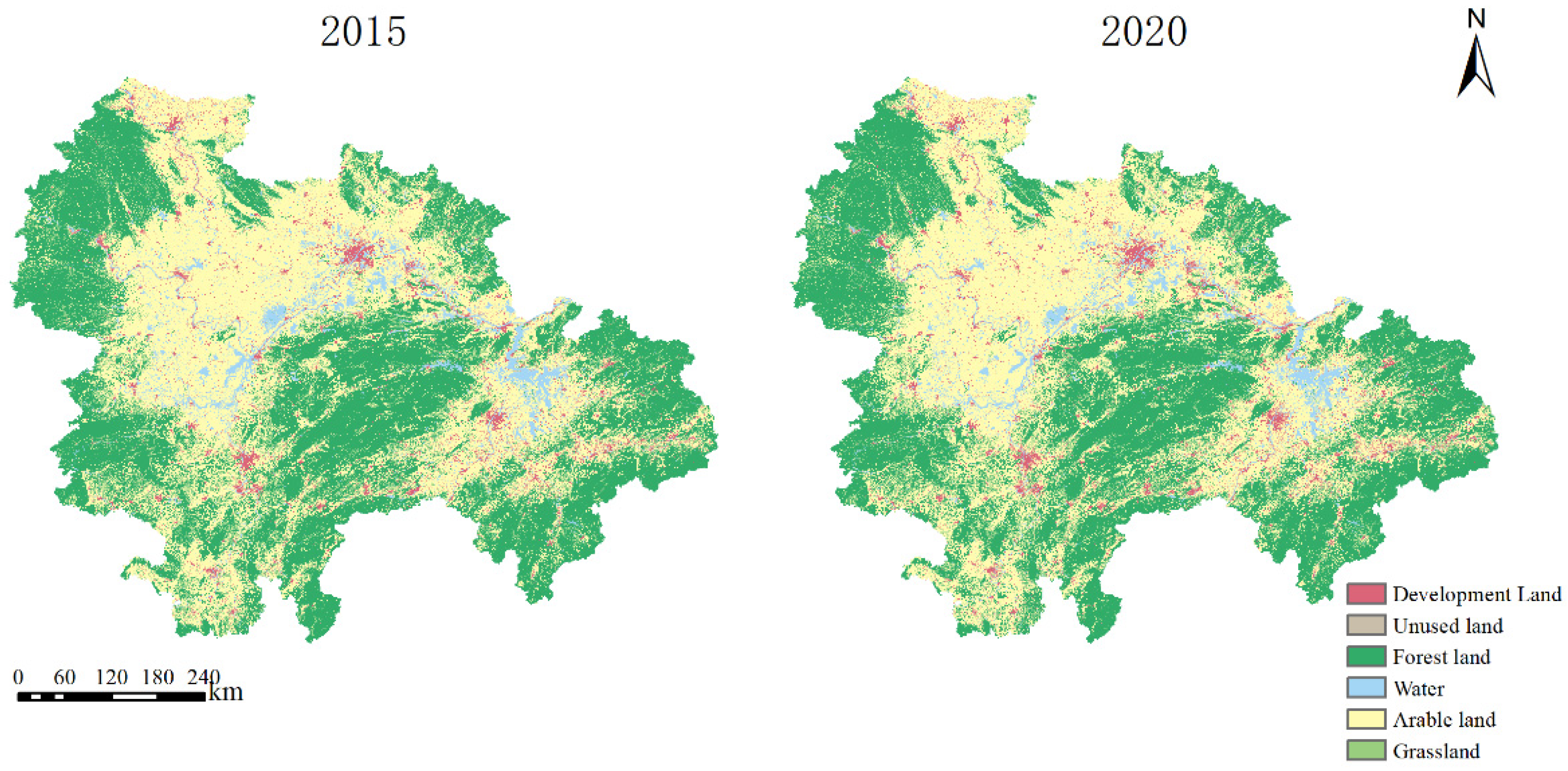
The results of the study demonstrate that the ESV of the study area shows a decreasing trend from 2015 to 2020, and the changes in its internal land types are an increase in arable land and development land, but a decrease in all other land types. In terms of the amount of change, development land changes the most, followed by forest land and water.
Since the implementation of the Development Plan for the MRYRUA in 2015, the economic growth rate of the urban agglomeration has been among the highest in the country, and the rapid economic development has inevitably resulted in the gradual artificialization of ecological land, which has led to a decline in its ESV. However, as the MRYRUA is a key area for national food security, the strict implementation of the Regulations on the Protection of Basic Farmland has led to an increase in the area of arable land in the MRYRUA, offsetting part of the decrease in ESV due to the decrease in forest land, grassland and water. Nevertheless, the contradiction between ecological protection and protection of basic arable land in the MRYRUA remains prominent. Considering that the ESV coefficients of water and forest land are greater than those of arable land, the policy of “returning arable land to forest land and lake” needs to be strengthened in the future in order to prevent ecological degradation. However, in the implementation of such policies, there are cases where arable land with slopes below 25 degrees is planted with trees, while forest land with slopes above 25 degrees is reclaimed for arable land. Although an unreasonable ecological layout may lead to a superficial rise in ESV, it may not actually be ecologically beneficial, so it is necessary to reasonably arrange the layout of ecological construction, plan the spatial pattern of the country according to local conditions and comprehensively consider biologically appropriate environmental and climatic factors, human settlement factors and various plans for urban construction.
The three scenarios projected for 2035 continue the downward trend, but the changes in the internal land types vary, causing the ESV to decrease to different degrees. The ESV decreases by 4.14% for the natural development scenario, by 4.36% for the urban expansion scenario and by 3.93% for the ecological conservation scenario.
The main reason for the difference between scenarios is that the ecological protection scenario sets up a restriction zone, which stipulates that land types within the restriction zone cannot be transformed, making the land changes more concentrated. This results in a more significant increase in high-value areas and a more significant decrease in low-value areas. Meanwhile, a cost transfer matrix is set to restrict the transfer between some land types, so that the land change in this scenario can only occur in a limited number of transformation types. In the other two scenarios without a restricted area, the land can vary to a greater extent, and although there are some differences between the overall ESVs, the differences are not significant when apportioned to each grid.
In recent years, the work of delineating “three zones and three lines” has been in full swing. The “three zones” refer to three types of land space: urban space, agricultural space and ecological space. The “three lines” correspond to the three control lines of urban development boundary, permanent basic agricultural land and ecological protection red line in the above three zones, respectively. The “three zones and three lines” can be equivalent to the restricted areas in the model. The research results show that the delineation of the “three zones and three lines” can restrict the transformation of a large amount of ecological land to development land, and can also make the transformation of land types more concentrated, thus improving ESV. In terms of driving factors, the contribution of population to the development probability of each category is high, especially for development land. If no restrictions on land use and town development boundaries are set, allowing the population to increase may lead to unlimited expansion of development land. Therefore, in the future development, apart from defining the “three zones and three lines”, it is also necessary to increase the intensive use of development land as well as its utilization. Due to the lack of saving and the intensive use of development land, there is a large amount of inefficient and idle land in some places. Thus, the government should guide the development and utilization of idle land in rural areas to improve the efficiency of land use. At the same time, it is also necessary to combine the “rural revitalization strategy” to attract part of the population to the prospect of moving outside the city, but it is necessary to avoid the further expansion of rural development land when the population moves to the countryside and gathers to a certain extent.
In addition, it is worth noting that the development land is mainly concentrated in Wuhan, Changsha and Nanchang, the three provincial capitals, in terms of land distribution. These three central areas are in the plains surrounded by arable land; the expansion of development land will encroach on a significant amount of farmland. With MRYRUA as the main production area of grain, the protection of arable land needs to be paid attention. The MRYRUA, as a mega-city cluster, has too large an area layout and spans too many provinces, which leads to insufficient radiation capacity of the central cities. In addition, the topography is complex within the city cluster; between the central cities is a large area of forest land and some water. In order to promote the regional integrated development of the city cluster, the transportation problem must be solved. The development of transportation in a sub-optimal way will inevitably affect the ecology, so when developing transportation integration, disregarding from the convenience of transportation, the site selection and layout should consider the ecological environment. Construction materials should be kept away from the water, and drains and seepage pits should be built to prevent leakage. After the end of road construction, green vegetation should be planted around the road as soon as possible to restore vegetation and to protect plants.


