Article

Improving the Earthquake Resilience of Primary Schools in the Border Regions of Neighbouring Countries

by
João M. C. Estêvão
1,2,*,
Antonio Morales-Esteban
3,
Luis F. Sá
4,
Mónica A. Ferreira
5,
Bruno Tomás
1,
Carlos Esteves
1,
Vítor Barreto
1,
Ana Carreira
1,
Alfredo Braga
1,
Maria-Victoria Requena-Garcia-Cruz
3,
Emilio Romero-Sanchez
3,
Jaime de-Miguel-Rodriguez
3,
Maria-Luisa Segovia-Verjel
3,
Beatriz Zapico Blanco
3 and
Carlos Sousa Oliveira
5
1
Department of Civil Engineering, ISE, University of Algarve, 8005-217 Faro, Portugal
2
CIMA—Centre for Marine and Environmental Research, UAlg, Campus de Gambelas, 8005-139 Faro, Portugal
3
Department of Building Structures and Geotechnical Engineering, University of Seville, 41004 Seville, Spain
4
Autoridade Nacional de Emergência e Proteção Civil, 2794-112 Carnaxide, Portugal
5
CERIS—Instituto Superior Técnico, 1049-001 Lisboa, Portugal
*
Author to whom correspondence should be addressed.
Sustainability 2022, 14(23), 15976; https://doi.org/10.3390/su142315976
Submission received: 31 October 2022 / Revised: 15 November 2022 / Accepted: 23 November 2022 / Published: 30 November 2022

Abstract

:
This work summarises the strategy adopted in the European research project PERSISTAH. It aims to increase the resilience of the population, focusing on the existing primary schools in the Algarve (Portugal) and Huelva (Spain) regions. Software was developed to assess the seismic safety of these schools, considering different earthquake scenarios. Seismic retrofitting measures were studied and numerically tested. Some of them were also implemented in the retrofitting activities of two case study schools (one in each country). It was found that the adopted ground motion prediction equations (GMPEs) considerably affect the results obtained with the software, especially for offshore earthquake scenarios. Furthermore, the results show that the masonry buildings would be the most damaged school typologies for all the scenarios considered. Additionally, a set of guidelines was created to support the school community and the technicians related to the construction industry. The goal of these documents is to increase the seismic resilience of the population. Different activities were carried out to train schoolteachers in seismic safety based on the guidelines produced, obtaining positive feedback from them.

1. Introduction

One of the 17 Sustainable Development Goals (SDGs) that were adopted by the Unit-ed Nations (UN) [1] includes resilience (goal 11: Make cities and human settlements inclusive, safe, resilient, and sustainable). In this context and in earthquake-prone regions, improving the earthquake resilience of communities is a very important issue. There are many definitions of resilience, with different types and dimensions [2,3]. Despite that, it seems evident that post-traumatic disturbance after an earthquake considerably depends on the resilience of the population [4]. This might be a relevant problem in schools due to the possible presence of very young children. This is even more problematic in primary school buildings. Therefore, it is crucial to improve the earthquake resilience of this type of construction to reduce the impact of catastrophic situations in the education system. In fact, school buildings have presented important seismic damage all over the world [5,6,7,8,9]. This can also be related to the relative position of school buildings to the earthquake rupture [10].
The reduction in the seismic risk is the result of a combination of actions, processes and attitudes aiming to improve resilience. These can be divided into three main groups of activities [11]: prevention (usually by building schools in proper locations and with an adequate seismic resistance), mitigation (by retrofitting the most vulnerable buildings and communicating this need to teachers, students and the whole community where the school is placed, for example), and preparation (by creating emergency plans, training in the earthquake context, producing guidelines for teachers and learning materials for students about this issue, and alerting the community to the seismic risk). In this context, civil protection agencies usually promote the development of tools for risk and crisis management, aiming to increase the protection of people and property against earthquake disasters.
Regarding the existing school buildings, prevention is not an option: it is not possible to change their location. Additionally, they might not have enough seismic resistance due to their construction date. In fact, they might not comply with the requirements of new seismic codes. To solve this problem, the only possible solution is to carry out activities related to mitigation and preparation.
The existing methods for the seismic vulnerability assessment of buildings can be divided into three major groups [12]: the empirical methods, usually based on statistical mean data obtained in post-earthquake scenarios and in expert knowledge; the analytical/mechanical methods, which are normally based on structural analyses to assess seismic safety according to different limit states (LS); and the hybrid methods, which gather characteristics of the other two methods.
The empirical methods are more suitable for large-scale seismic risk studies. The analytical/mechanical methods seem to be more adequate to study individual buildings. This is due to the possible differences in the results of each type of approach, as shown by recent studies [13].
The seismic vulnerability of the structural elements of school buildings is of great importance. In fact, it can lead to the collapse of the building. However, it is also important to understand the seismic behaviour of non-structural elements. Recent tests, carried out on shaking tables, highlighted the effects of earthquakes on non-structural elements that usually exist in buildings [14]. This might be especially important in buildings presenting low seismic vulnerability, or in general when buildings are subject to low levels of vibration. This is especially important when there is the possibility of a high concentration of people, as in school buildings.
Past earthquakes seem to evidence the key role that schools have with regard to society in the event of an earthquake and at different levels [15]. Besides their importance regarding seismic performance, it is also necessary to ensure that teachers are trained. They can better transmit their knowledge about earthquakes to the students but also act accordingly in case of a seismic emergency [16,17]. The importance of schools in the seismic resilience of a modern society is the goal of many studies. These adopt a wide range of strategies based on the requirements of each country where the study is carried out. In addition, they bear in mind the number of school buildings that are studied. Thus, it is necessary to understand the real structural behaviour of each school building, either through laboratory studies [18] or complemented through numerical studies.
Recent works using more rigorous analytical methods have been normally carried out only for individual buildings, such as schools or hospitals. In this context, it is usual to adopt nonlinear static analyses [19,20,21,22,23] or nonlinear dynamic analyses [24,25,26,27,28,29]. The latter are more rigorous, but they require more computational effort. These aspects should be considered in the case of large-scale studies. However, the use of these methods is also the best way to understand the influence of the level of conservation on the seismic safety of schools [30]. They are also useful to evaluate the effectiveness of seismic retrofitting measures [31,32]. Simplified empirical methods are widely applied as well [33]. Contrariwise, these are essentially supported by visual inspections and expert knowledge and can be easily applied to a large number of schools [34,35].
For large-scale studies on the seismic safety of schools, it is common to use algorithms from other scientific areas, using empirical information to maximise the accuracy of the results. Such is the case of machine learning (expert systems, genetic algorithms, and neural networks, for example) [36,37,38], as well as the development of specific computer tools [39,40].
It should be noted that earthquake effects cross borders between countries. Therefore, studies should not be limited by these national borders, such as is the case of the European research project PERSISTAH (Projetos de Escolas Resilientes aos SISmos no Território do Algarve e de Huelva, in Portuguese, or Projects of Earthquake-Resilient Schools of the Algarve and Huelva, in English). The area under study is the Algarve (Portugal) and Huelva (Spain) provinces, which are next to each other near the Portugal–Spain border. The project is focused on the agreements of Hyogo [41] and Sendai [42] on the cooperation to reduce countries’ seismic risk.
The research steps of the project are outlined in Figure 1. First, a survey of the existing primary schools in the regions under study was carried out to create a database. Then, nonlinear structural analyses of a set of school buildings of different construction dates and structural systems were carried out. The outputs of these analyses were added to a software that was developed in the context of the PERSISTAH project. This allows us to perform the seismic assessment of individual school buildings and create ranked lists based on their individual safety. These lists can be instantly exported to a KML file and displayed in Google Earth, or in Google Maps, with a colour scale. Additionally, this allows us to place the maps with the results on a website with an intuitive and interactive interface. This information is especially useful for civil protection authorities. The results are helpful to support mitigation and preparation activities (from enhancing emergency planning to facilitating technical training and exercises, in the civil protection context). Furthermore, it enables us to improve the risk communication to the population. After identifying the most vulnerable school typologies, two case study schools were selected for their seismic retrofitting (one located in the Algarve and the other in Huelva). Training actions were also carried out for teachers and for the technical community of the two regions under study. Several guides were produced to support teachers, students, and civil construction technicians.
As mentioned, owing to the difficulties of large-scale seismic risk studies of schools, it is usual to simplify the seismic vulnerability assessment procedures. However, this entails a substantial increase in uncertainty regarding the reliability of the results, which is often unknown. The innovative feature of the PERSISTAH project is related to the use of the most advanced structural analysis methods that are established in the Eurocodes for the large-scale assessment of school buildings. To do so, a computer tool, which allows us to improve the knowledge about the main factors that may influence the seismic behaviour of school constructions, was developed. This information was also included in the guides that were created to help civil construction professionals. More than just thinking about creating a finished, watertight product, which often characterises this type of research project, it was sought to create a methodology and a set of tools that can be continuously updated, namely for civil protection purposes.

2. Developing a Computational Strategy for the Seismic Assessment

Software was developed in the framework of the PERSISTAH project due to the high number of primary schools in the Algarve–Huelva regions. The main goal of this software is to identify school buildings that do not comply with the safety criteria established in the seismic codes that are mandatory in each country. The software was developed in Object Pascal (Delphi) and consists of several modules (Figure 2). These modules are associated with a set of independent, yet fully interconnectable, computational objects [43] that resulted from the dismemberment of previously developed software, such as SIMULSIS [44]. This feature gave the new software unique characteristics since it inherited the attributes of the original computer programmes in a symbiotic way, such as the user interfaces.

2.1. Schools Database

The data about schools were gathered and included in a database. Similar information was obtained for schools of each country and used in the adopted seismic safety assessment procedure. Instead of using a generic database software, a specific database was developed adopting some innovative strategies. Such is the case of the creation of a visual system that allows the user to easily have access to information about schools. The database allows us to save that information and export it to external software since it is georeferenced. It enables the creation of a KML file to use in Google Earth or MS Excel files directly through the clipboard.
In total, 281 primary schools in the Algarve–Huelva region were added to the database. Each school campus might be composed of several buildings or structurally independent modules. In some cases, these buildings were built at different times, and they might present different structural systems. Therefore, evaluating their seismic safety with high accuracy is difficult to accomplish.

2.1.1. Primary Schools in the Algarve Region (Portugal)

Many of the existing school buildings in the Algarve were built with standardised designs. This facilitated the study of their seismic safety given the high number of existing schools. However, it was not possible to analyse all the buildings of the 142 schools that were included in the database because the structural configurations of the buildings were rather different. Thus, the study focused on studying the buildings that could be more vulnerable based on their characteristics: (i) traditional masonry buildings; (ii) reinforced concrete (RC) structures constructed prior to the application of the seismic codes in Portugal; (iii) existing buildings with much lower seismic requirement levels than those currently established by Part 1 of Eurocode 8 (EC8-1) [45] and the respective National Annex (NP EN 1998-1:2010 [46]).
Some of the most vulnerable constructions are the oldest masonry school buildings. It should be noted that these buildings were constructed according to a set of standardised designs developed for the Algarve by several architects before the first Portuguese seismic code. They are part of the so-called “Plano dos Centenários”. Examples of these designs are those created by Raul Lino in the 1930s, Alberto Braga de Sousa in the 1940s or Fernando Peres in the 1950s. In this case, it was possible to gather information of the architectural designs of most of those schools. Additionally, documents related to the construction works were also available. Therefore, it was possible to carry out the structural analysis of many buildings belonging to these typologies. Many of these buildings are still functioning as schools; others are occupied by Administrations [47].
The following standardised designs date from the 1970s. In this case, this group of buildings has RC structures. The architecture designs of the so called “P3” schools were created at this time. This is an RC typology commonly found in the Algarve. Unfortunately, no structural blueprints were found. Fortunately, these buildings present columns and beams with exposed concrete. It was possible to identify the location of the reinforcements, as well as the mechanical properties of the materials, based on the results of in situ non-destructive testing procedures. This knowledge allowed the determination of capacity curves [48].
In the case of most modern schools, each building has its own design, not following standardised ones.

2.1.2. Primary Schools in the Huelva Region (Spain)

In Huelva, a total of 139 primary schools (269 different buildings) were identified. First, they were grouped according to their structural system and to their date of construction. Later, they were classified according to their geometry and their volumetry. It was found that 82% of the buildings were constructed with RC frames, 13% with unreinforced masonry walls and 4% with steel frames. It was not possible to identify the structural system of only 1% of the buildings.
Regarding the construction date, 48% of the buildings were built during the 1970s and 1980s; therefore, they were built before the application of seismic codes in Spain. Most of the masonry buildings were built before 1970, while the RC buildings were mainly constructed after that period (1970s–1980s). Regarding the geometry, they were classified into six different groups according to the aerial views and on-site visits: compact, linear, prism, intersection, juxtaposition, and sportive. It was found that 36% and 34% of them are compact or linear, respectively. The compact buildings are characterised by a square shape, while the linear structures are rectangular. Further information on the classification of the buildings can be obtained in [49].

2.2. Seismic Action

This is a module of the developed software in which it is possible to select the seismic action to be used in the seismic safety assessment of each school building. Different types of seismic actions can be selected: (i) the code-based seismic action, mandatory in each municipality where the school is located, to verify the compliance of the legal requirements; (ii) the seismic action resulting from a given earthquake scenario, to support civil protection activities.

2.2.1. Code-Based Seismic Action

In this case, the seismic action is represented by the EC8-1 response spectrum. A computational object was created with different subclasses, one for each country. The same computer routines were always used, regardless of the country, the region, and the municipality. Therefore, the results were more easily obtained. For the Algarve, the response spectra established in the mandatory NP EN 1998-1:2010 [46] were implemented. For Huelva, the current Spanish seismic code, the NCSE-02 [50], was implemented.
By using this software, it was easier to compare the differences between the maximum values of the design ground acceleration for schools in the border regions of the Algarve and Huelva. The peak acceleration ag of the EC8-1 (Equation (1)), which depends on the reference peak acceleration (agR) and on the importance factor (γI), is equal to:
a g = a g R   ·   γ I
It is evident that the seismic hazard does not bear in mind borders between countries. Therefore, the seismic codes of each country should not present very different values. In fact, this is the idea on which the European Seismic Hazard Model (ESHM) was based, which supported the creation of the ESHM13 [51] and the new ESHM20 [52] models. Contrary to this idea of harmonisation, it was possible to observe very significant differences on the border between Portugal and Spain (Figure 3). This is due to two reasons: (i) the reference peak ground accelerations (agR) are higher in the Portuguese seismic code for the Algarve region; (ii) the importance factor for schools is higher than one in the NP EN 1998-1:2010 for the Algarve region, while this value is equal to one in the NCSE-02 for the Huelva region. From a practical point of view, the return period (TR) of the seismic action that must be used to check the safety of schools in the Algarve is 821 years, in accordance with the Portuguese National Annex of Part 5 of Eurocode 8 (EC8-5) [53], while in the region of Huelva, the Spanish NCSE-02 adopts TR = 475 years.

2.2.2. Earthquake Scenarios

This functionality implemented in the developed software enables the definition of earthquake scenarios. This is particularly useful for the civil protection authorities since it allows us to assess the possible impact of this natural phenomenon on the evaluated schools. For each earthquake occurrence scenario, it is necessary to define the magnitude of the event, the characteristics of the rupture (which can be a point source, a line, or a plane), the type of seismic fault, and the geographic location of the earthquake rupture.
It seems evident that it is not scientifically correct to idealise earthquakes of any magnitude and location. This may lead to effects on school buildings whose probability of occurrence is quite low. In this work, to illustrate the potential of the software developed, scenarios whose magnitudes are stipulated in official documents were chosen [53]. Their locations are selected according to the seismic faults identified in international scientific publications, or where earthquakes have occurred in the past.
It is not usual for seismic codes to establish the magnitude of the earthquakes for a given seismic action because they express seismic actions throughout a uniform probability response spectrum. Therefore, they do not correspond to an isolated event and location, but to a set of seismic events related to a certain probability of exceedance. Nevertheless, hazard disaggregation analyses [54] can enable the establishment of scenarios for the occurrence of earthquakes with return periods consistent with those established in a seismic code. To do so, two types of events were selected according to the magnitudes indicated in the Portuguese National Annex of the EC8-5 [53] for liquefaction studies in the Algarve region: an offshore far-field earthquake with magnitude M = 7.7, and a near-field earthquake with magnitude M = 5.2. Both correspond to a return period of 821 years. For a return period of 475 years, the magnitudes for these two scenarios are M = 7.4 and M = 5.1, respectively. Nevertheless, the possible locations of these seismic events are not indicated in the EC8-5. The seismic hazard disaggregation analysis [54] showed that the São Vicente Canyon area is the one with the highest probability of originating the seismic action established in the EC8-1 for the Algarve region. The zone between the Guadalquivir Bank and the Guadalquivir Fault [55] is another area with high seismic activity. It corresponds to a cluster [56] where there seems to be seismic faults whose total dimension can originate an offshore earthquake of magnitude M = 7.7.
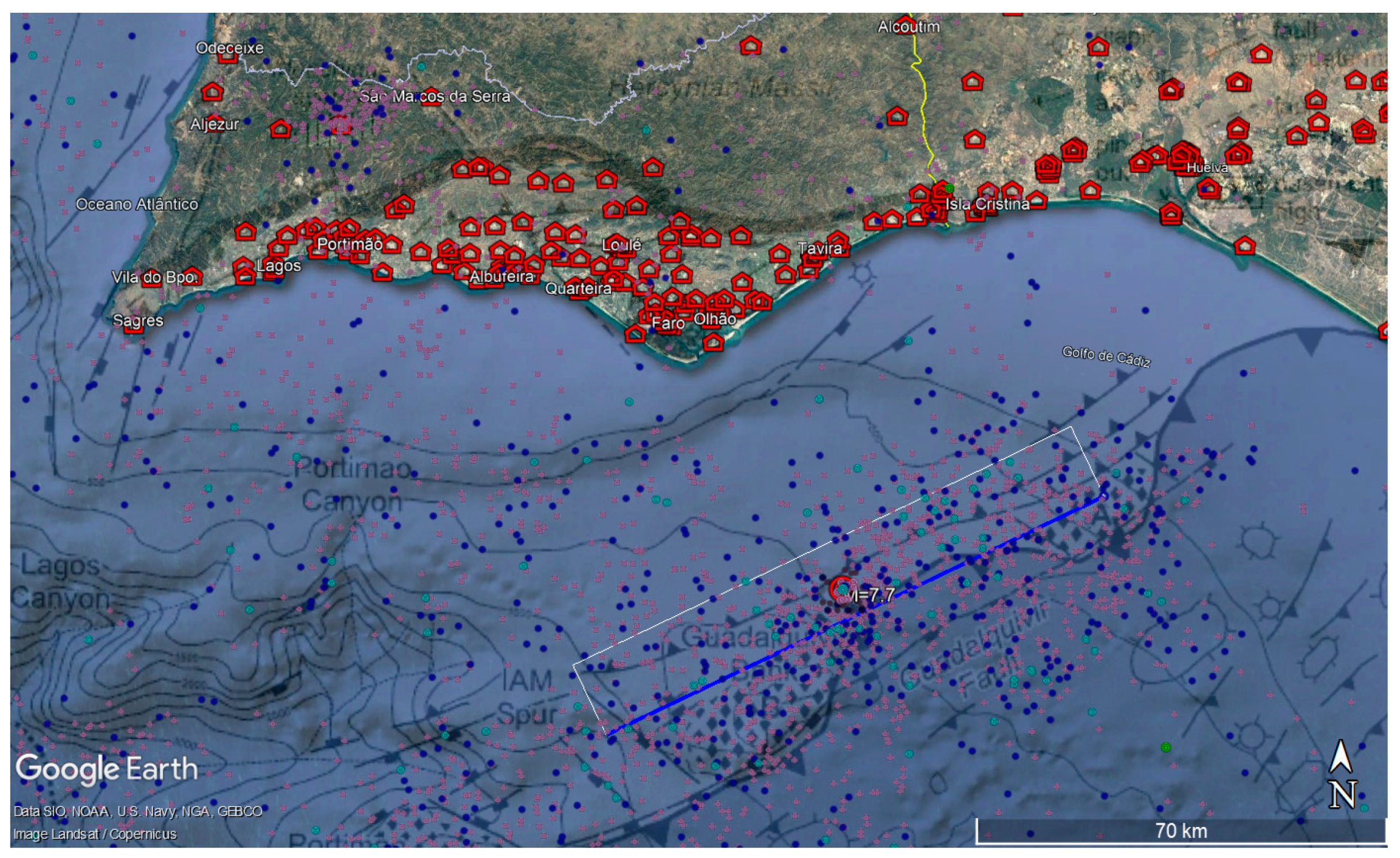
According to the Spanish IGN [57] (Instituto Geográfico Nacional) earthquake catalogue, an earthquake of a magnitude greater than 4.5 (happening in this offshore area after 1961) occurred on 3 January, 2005, with an epicentre located at latitude 36.6161° and longitude −7.5947°. This corresponds to an earthquake of magnitude M = 4.9. This is an area where earthquakes usually have focal mechanisms of the reverse type [58]. For the far-field scenario, the coordinates of the abovementioned earthquake were adopted (Figure 4). The rupture plane dimensions were obtained according to an empirical expression [59]. The adopted azimuth of the fault was equal to 244.5° and the dip angle was 64°. The primary school that is closest to the epicentre is in Portugal (Escola Básica de Ilha da Culatra) at an epicentre distance of 47.1 km. Near the border, the school that is closest to the rupture is in Spain (Colegio Virgen del Carmen) at 43.3 km from the fault plane.
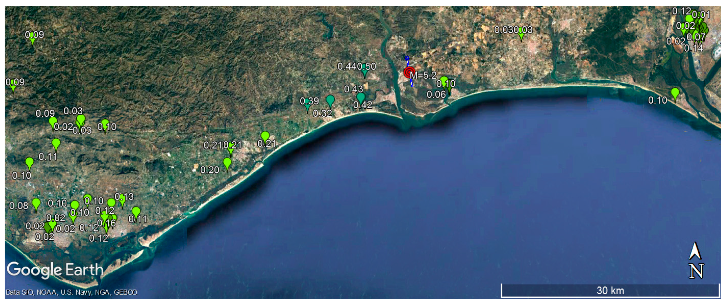
The largest onshore earthquake recorded after 1961 that exists in the IGN catalogue occurred on 20 December 1989. This occurred at a latitude of 37.225° and a longitude of −7.3917°, with a depth of 23 km and a magnitude of M = 5.0. In this area, earthquakes normally present strike–slip focal mechanisms [58]. The closest primary school to the epicentre is in Spain (Colegio Galdames) at about 1.2 km. Thus, this location seems to be quite good for establishing the near-source earthquake scenario for the present study, with a magnitude of M = 5.2. A strike–slip rupture was adopted, with a focal depth of 13 km and a vertical plane aligned with the Guadiana River (Figure 5).

2.3. Vulnerability Evaluation

As mentioned in the introduction, there are several possible approaches for assessing the seismic vulnerability of existing schools. The objectives of the PERSISTAH project were to analyse the seismic safety of these buildings according to the legal framework of both regions under study and to rank the seismic risk of school buildings for seismic retrofitting purposes. Therefore, it was opted to apply the seismic structural analysis methodologies presented in Part 3 of Eurocode 8 (EC8-3) [60], considering the limit states (LS) established for the Algarve in the NP EN 1998-3:2017 [61]. These are usually adopted for the seismic assessment of a single building. However, in this case, they were applied to a large number of school buildings throughout the development of the computer routines that were developed to automatically carry out this task [43] as if each building were analysed individually. From all the different seismic analysis approaches proposed in the EC8-3, nonlinear static seismic analyses were selected. First, a different software was used to perform nonlinear static analyses to compute the capacity curves of each school building following the requirements of the EC8-3 (12 for each building, in most cases). These capacity curves were then imported into the PERSISTAH software to rank the seismic safety of the school buildings according to different possible seismic actions.

2.3.1. Capacity Curves Obtained for the Algarve Region (Portugal)

Regarding the Algarve region, particular attention was given to the unreinforced masonry (URM) school buildings that were built before the first Portuguese seismic codes. The capacity curves of these buildings were determined according to the principles and rules defined in the EC8-3 [47], using the TreMuri software [62]. In the case of RC schools built in the early 1990s, it was not possible to check the safety levels currently required in the NP EN 1998-3:2017 for all the LS. As concluded in [63], the level of seismic vulnerability of this type of structure seems to be much lower and much less worrying. However, RC buildings designed before the 1983 Portuguese code, namely the so-called “P3” schools [48], present low shear reinforcement ratios in their columns. For these buildings, the nonlinear structural analyses were carried out with Seismostruct [64]. The results show premature shear failures. In this case, as already carried out in earlier studies [65] and considering the civil protection purposes, a residual shear strength of the columns was adopted to reproduce the expected degree of damage for higher displacement values.

2.3.2. Capacity Curves Obtained for the Huelva Region (Spain)

In the case of Huelva, the seismic assessment of the buildings was carried out according to the performance-based method. In a similar way to the Algarve, the seismic safety was verified according to the EC8 requirements. The capacity of the buildings was obtained according to different numerical modelling procedures. The seismic hazard was acquired according to the seismic code in Spain (NCSE-02) [50] and the Spanish update of the ground acceleration values [66].
For URM buildings, the TreMuri software was also used. In [67], the optimal seismic retrofitting of a URM case study was analysed. It was representative of the URM buildings identified in the area. It was found that this case presents a probability of “collapse” and of “severe damage” of 45% and 40%, respectively. Furthermore, it presented a very low ductile behaviour. It was concluded that the most effective solutions (according to a cost–benefit analysis) were the addition of encirclements with L-shape profiles and steel grids spaced at certain distances.
The seismic assessment was mainly focused on RC buildings. This was due to the amount of them and to the available data at different local archives (such as blueprints and reports). Different software was used to numerically model the buildings, focusing on the use of OpenSees [68]. The ageing effects of the RC frames, the infills, the irregularities in plans and in height or the presence of smooth rebar were considered in the analyses, as presented in [69]. The soil–structure interaction effects have also been tested [70]. It was found that they can worsen the capacity of the medium-rise buildings up to 10%. Additionally, the seismic retrofitting of different case study buildings representative of different typologies has been analysed. Further information on the seismic assessment of the buildings can be found in [49].

2.4. Ranking School Buildings

Given that funding is usually limited, it is important to establish seismic safety rankings to identify the buildings with a higher risk. This can be obtained according to the seismic hazard of the site and the vulnerability of the buildings. This type of analyses is especially important to set the different seismic retrofitting intervention priorities and in relation to higher importance classes [71]. Schools are one of those groups of buildings for which different types of rankings were suggested, usually based on the ratios between capacity and demand associated with a certain LS [72].
In the PERSISTAH project, a similar procedure was adopted to rank the schools. In this case, the adopted school score corresponds to the expression presented below (Equation (2)). This was implemented in the software developed. This score s c o r e L S is inversely proportional to the percentage of the seismic action % S e , L S , associated with a given LS, defined from the seismic performance [43]. If the reference seismic action is the response spectrum established in the EC8-1, then this corresponds to the inverse of the coefficient γ L S [47]. This should multiply the seismic action corresponding to the reference return period.
s c o r e L S = 100 % S e , L S = 1 γ L S
The LS might be a life-saving LS, which is related to the LS of significant damage (SD) of the EC8-3, or to the collapse LS, which is related to the LS of near collapse (NC) of the EC8-3. It can also be any other LS related to full operational performance (OP) or damage limitation (DL), depending on the goal of the study. The higher the score, the higher the seismic risk and, therefore, seismic retrofitting interventions are more needed.
Further studies would consider other important variables to define a more complex but more realistic score, in linking educational facilities and those essential utilities, such as power, water, and sewers, to be available for the functionality of school systems after disasters [73].
A set of factors that affect the functionality of schools includes the performance of non-structural elements, the number of students in each school and the difficulty in assessing the school. The decision to reopen schools after disasters involves not only the school building, the school administrators or staff, but also the damage to community buildings and infrastructure after an earthquake. A multi-criteria approach can be helpful for the construction of a global school score.

3. Retrofitting of Pilot School Buildings

The seismic retrofitting of school buildings has received particular international attention [74,75,76,77,78,79,80,81,82]. After identifying the schools with the highest score in the ranking, it is necessary to select a set of retrofitting strategies. These depend on the type of existing structural system and its dynamic characteristics. They also depend on the ratio between the seismic demand and the capacity of the structure.
In regions where there is no tradition of seismic retrofitting, it is very important to train technicians to carry out the task. In this context, one of the goals of the PERSISTAH project was to perform the seismic retrofitting interventions of two pilot schools. To do so, one school in the Algarve region (Portugal) and another in the Huelva region (Spain) were selected so that they could serve as examples for the two studied regions. The selection of the schools was made based on their school score and the money allocated for the task. Finally, two small masonry school buildings were chosen.

3.1. The Brancanes Primary School (Olhão, Algarve, Portugal)

As aforementioned, one of the typologies of masonry schools that still abound in the Algarve is the schools designed by the architect Fernando Peres. The Brancanes primary school is one of those schools (FP2 [47]). It has a single storey. Sometime after its construction, a new space was added. This new building was separated from the original construction and possesses an RC structure. The original classrooms have two independent entrances because the school was built in 1961, when there was still a gender separation in Portugal. The masonry walls, which support an RC slab, are made of limestone from the region and lime–sand mortar.
The structural analysis of the original masonry building indicated that the school did not have the appropriate level of seismic safety [83]. The adopted retrofitting solution consisted of wall jacketing (Figure 6). Two layers of pre-mixed lime mortar were applied to the opposite faces of the walls. These were connected by means of transverse inox ties through the masonry, as proposed in the EC8-3. The selection of lime-based mortar, instead of cement mortar or concrete, aimed to ensure the physical, chemical, and mechanical compatibility of the new material with the existing one. The choice of inox ties was due to durability issues.

3.2. The Los Lanos Primary School (Almonte, Huelva, Spain)

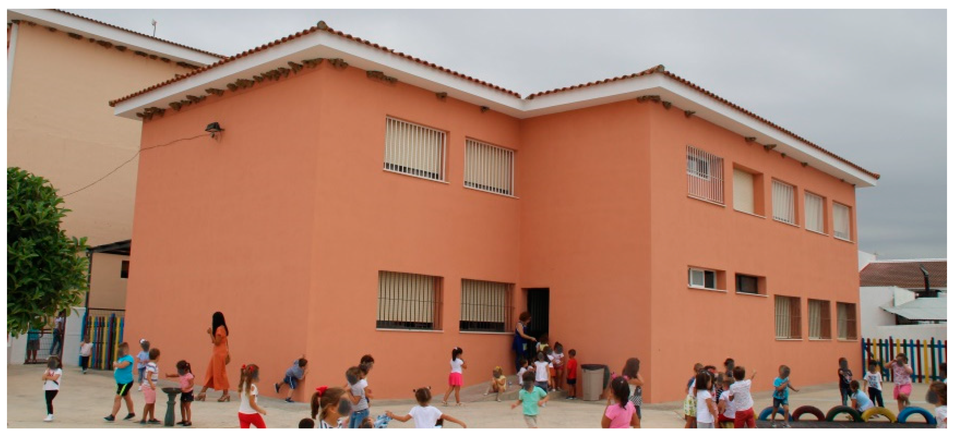
The building selected for retrofitting is a small URM two-storey building built in the 1980s. The walls are 25 cm thick, with rigid RC floors. It has a sloped tiled roof and shallow concrete foundations. The openings on the façade are located on the longitudinal walls, while the walls in the orthogonal direction are blind (Figure 7).
Its vulnerability evaluation was performed as explained in Section 2.3, resulting in one of the highest school scores of the area studied. Moreover, the building does not comply with the seismic code requirements. The uneven distributed openings represent the main seismic weakness of the building. The probability of severe and complete damage in its weak direction is quite high.
Therefore, the search for retrofitting solutions focused on the mitigation of the weak direction openings’ effect and, thus, the reinforcement of the façade walls. Three potential solutions were considered: external wire mesh, carbon fibre-reinforced polymer (CFRP) mesh and steel rebars around openings. They were selected based on the following features: (i) easy execution from the outside of the building, (ii) low cost/effectiveness ratio, (iii) low/no architectural impact and, of course, (iv) improvement of the seismic behaviour of the building.
This last feature was studied following the method described in Section 2.3, finding that the retrofitted models outperform the as-built one. A higher resistance capacity and a notable reduction in the target displacement at the performance point for all of them was obtained.
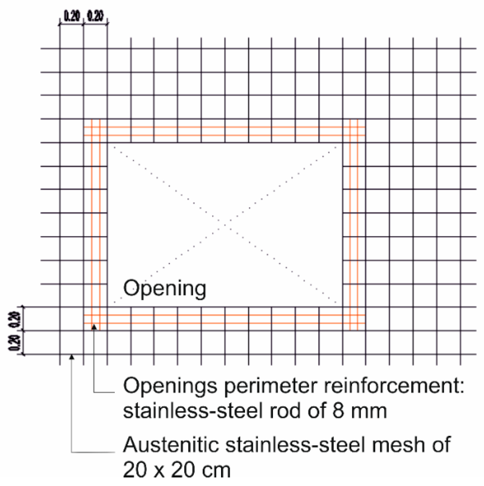
In particular, the larger improvement was provided by the combination of two of the methods (Figure 8): the application of an external steel mesh on the façade walls plus the reinforcement of the openings by means of rebars. The analysis of this solution showed that it increases the global stiffness of the structure, reducing deformations. The steel mesh provides an increase in the maximum strength, while the rebars at the openings contribute to a reduction in the displacement at the performance point. The CFRP technique, by contrast, showed the worst improvement/cost ratio and was, therefore, disregarded.
The combination of the steel mesh and rebar around the openings was implemented. A 20 × 20 cm Ø8 mm mesh was put on the external walls and 2 Ø8 mm rebars were hung around each opening. The solution was quickly and easily implemented by a regular local firm, with no special training. It was relatively cheap, and both the aesthetics and the functionality of the building remained unchanged.

4. Risk Communication

It has been observed that populations are not aware of buildings’ seismic risk, even in societies that have modern seismic codes and where earthquakes are frequent. It has been found that even in seismic-prone countries such as Chile, expectations about the seismic behaviour of constructions have been unrealistic [84]. Populations should be aware that, even if a building meets all the seismic safety requirements established in a modern code, they are not designed to withstand earthquakes without damage. Moreover, it may even be economically unfeasible to repair it after a very intense earthquake. The primary goal of a well-designed structure is related to life safety issues. Depending on the seismic code, a moderate earthquake can cause moderate or severe damage mainly of the non-structural elements. This might affect the operation of the facilities for a long time.
In this context, it is important to promote education of and information for the population to contribute to increasing the resilience of the society to these natural phenomena. The school context seems to be an important vehicle to achieve this goal. Moreover, school buildings also suffer the effects of earthquakes. Given the high concentration of children and young people in schools and the fact that they spend a large part of their time in school, the consequences of any structural and non-structural failure could be fatal for them.
Schools play a key role in supporting their communities after an earthquake. Teachers, principals, and non-teaching staff assume roles that go beyond educational leadership. They must deal with an immediate crisis, running schools as community centres after the disaster. Moreover, they must be sensitive to the physical, emotional, social and psychological needs of their students and families [16].
The positive effect of educational programmes on children affected by a very destructive earthquake is known [85]. So that teachers, monitors and technicians in the educational area can fulfil this goal, it is necessary for them to have pedagogical and didactic resources for the initial and continued training of the school community. Given the lack of this material in the regions under study, the Why does the ground shake? [86] and Practical guide for earthquake resilient schools [87] guides were created, which are available in three different languages (Portuguese, Spanish and English). These tools can be used in three types of learning (formal, non-formal and informal). This way, it facilitates the interconnection between the learning of the subjects and the domains of the primary school curriculum. Thus, it is intended to teach educators and children about the seismic phenomenon and the reduction of risk, in a creative, pedagogical, and playful way. Therefore, various activities that promote individual and collective participation were integrated. In this way, a culture of safety is developed in children so that they can transfer it to other moments of their daily lives and to the general population. In this context, special attention was given to problems related to non-structural elements, namely in the guides that were created [87], where issues related to the preparation activities that it is possible to carry out were focused on.
The educational guide Why does the ground shake? was tested and implemented from the beginning of the PERSISTAH project, namely, it was used with students from pre-school (five-years-old) and primary education (6 to 12-years-old). Two training courses for teachers were also held in Almonte (Huelva, Spain) and in Olhão (Algarve, Portugal). This allowed us to test the methodology and prove its practical success (Figure 9).
Recently, during the COVID-19 pandemic lockdown, it was possible to use the Why does the ground shake? educational material and participate in the Portuguese programme #EstudoEmCasa, aimed at students from the 1st to the 9th grade [88]. The TV programme was broadcasted on RTP Memória, RTP Internacional and RTP Play.

5. Results and Discussion

One of the main difficulties of the PERSISTAH project was to establish the earthquake scenarios of many schools spread over the two neighbouring countries. This is a very challenging task. On the one hand, it is challenging because the scenario should be plausible, and the earthquake should take place in areas with well-known seismic sources. This is very complex when dealing with offshore seismic sources. On the other hand, it is challenging because, if the results are accessible to everyone, they may generate panic in the school community without absolute certainty concerning the occurrence of those scenarios. In this context, it is very important to validate the results properly. This can be done by comparing them with identical scenarios that occurred in the region studied or, when that information does not exist, in other regions of the world. Unfortunately, even though the Algarve–Huelva region has been affected by several destructive earthquakes throughout its history [89,90], no instrumental records have yet been obtained in the region regarding a major destructive earthquake.
The 28 February 1969 (Ms = 8) earthquake caused the collapse of some buildings in the Algarve (masonry buildings). However, the rupture was very distant and only one strong motion record was obtained in a station located in Lisbon [91], very far away from the earthquake source.
Given the evaluation method adopted [43], it is necessary to use GMPEs that present spectral values and not only peak ground acceleration (PGA) values. Unfortunately, there are no such GMPEs established for this region based on earthquake records.
It is important to emphasise that the purpose of this study is not to validate the scenarios defined in Section 2.2.2, whose magnitudes are established in the Portuguese National Annex of the EC8-5, but the possible damage effects of these scenarios. Thus, the choice of which GMPE to use is of utmost importance. It should reproduce the spectral values that the earthquakes may generate in the various study sites. Moreover, there might be some unexpected results, concerning both high and small-magnitude earthquake events, which are not captured by some GMPEs. This is due to the incomplete knowledge of how all the factors that influence the level of vibration in a given place come together [92].
There are multiple GMPEs that are proposed by different authors, but not all of them were established with earthquakes that cover the range of magnitudes and distances that are required for this study. Some GMPEs adopt the epicentral distance, others the hypocentral distance, others the Joyner–Boore distance, and others the closest distance to the rupture plane, or a combination of some or all of them [93].
For large magnitudes, as is the case of the far-field earthquake scenario presented in Section 2.2.2, the dimension of the rupture may be very large, so it might not be rigorous to use the epicentral distance or the hypocentral distance. To better understand the impact on the results of this issue, an analysis of the effects of the onshore Amberley (New Zealand) Earthquake of 13 November 2016 (magnitude Mw = 7.8) was carried out. This was done by consulting the acceleration records that exist in the “Center for Engineering Strong Motion Data” [94], recorded in stations from the GNS network. If we analyse the records obtained in the Seddon Fire Station (SEDS), located at an epicentral distance of 145.3 km, but just 23.0 km from the fault, it is possible to see that the PGA was 0.759 g, which is a high value for such a long epicentral distance (probably due to the proximity to the rupture). However, in the Lake Taylor Station (LTZ), at a closer distance to the epicentre (64.3 km), but at a farther distance from the fault (52.8 km), the PGA was just 0.094 g. Obviously, this might be also due to site effects or to the relative distance to existing fault asperities, and not only to the distance from the fault. However, this phenomenon can also be observed in other stations, such as the Blenheim Marlborough Girls (MGCS), for which the soil characteristics are known (Vs30 = 210 m/s) [95]. This is located at an epicentral distance of 155.1 km, but only at 42.7 km from the fault, and presented a PGA of 0.269 g. Moreover, the importance of the distance to the ruptured fault plane can also be observed in other earthquakes, or through the results of stochastic simulations [44]. This type of comparison was also carried out by another author for Nepal, in the context of the Gorkha earthquake (Mw = 7.8) that occurred on 25 April 2015 [96]. This means that the distance to the fault plane rupture seems to be a better choice, regarding accuracy issues, when selecting a GMPE to deal with high-magnitude earthquake events. For this reason, an attempt was made to find a GMPE that is a function of the shortest distance to the rupture (RRUP), for computing the response spectrum of each school site. This type of GMPE is more complex to use because more parameters are needed. In addition, this is more difficult to implement in software, but it seems to be more accurate [97]. In this type of more general mathematical expression (Equation (3)), the spectral acceleration S a T is a function of the period (T) and of all, or just part, of the following parameters: the earthquake magnitude f M T ; the distance to the source f R T , which depends on the adopted GMPE, which considers both geometrical and anelastic attenuation; the type of the earthquake fault f F T ; a hanging wall term f H T ; a fault dip term f D T ; the site geologic conditions f S T , usually a function of the V S 30 value; and a basin response term f B T .
l n   S a T = f M T + f R T + f F T + f H T + f D T + f S T + f B T .
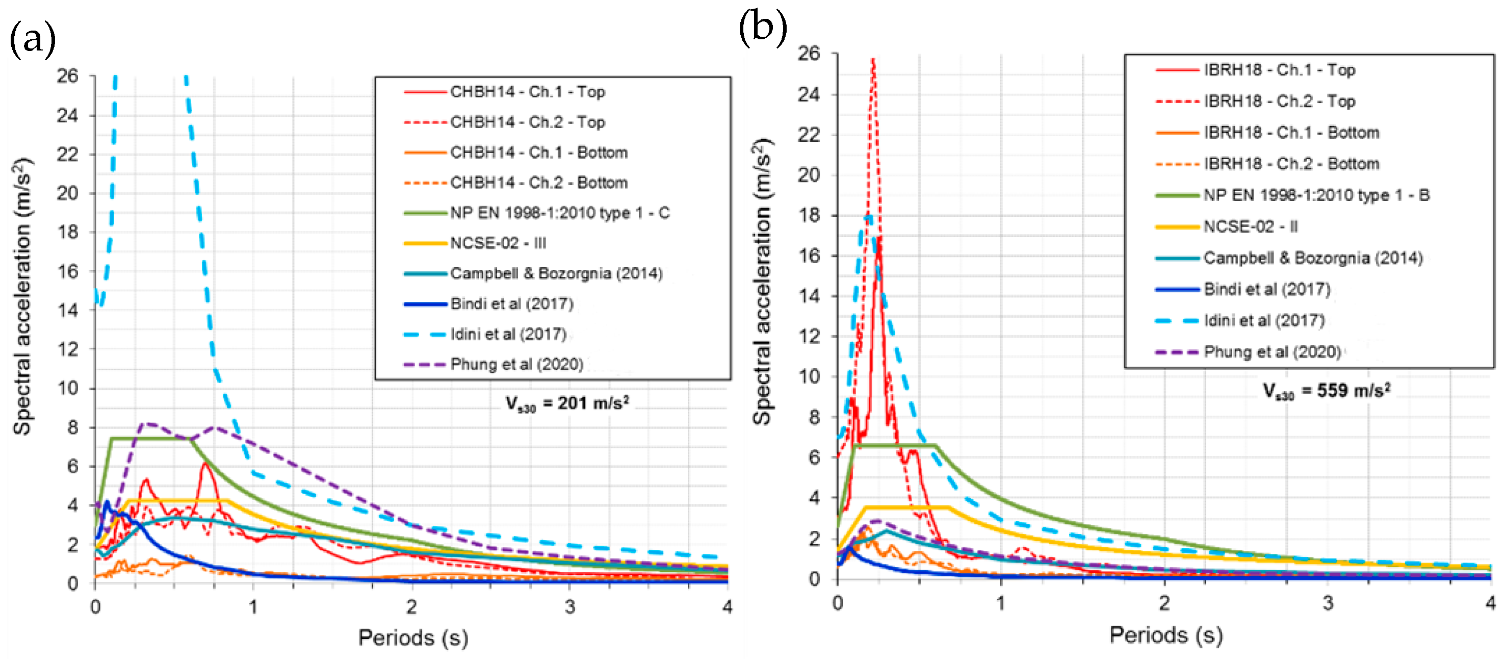
To better understand the accuracy that we can expect for the selected damage scenarios, the results of the GMPEs [98,99,100,101,102,103] that were implemented in the developed software were first compared with response spectra obtained from earthquake records. The first set was recorded in the CHBH14 (Vs30 = 201 m/s, ground type C of the EC8-1, focus distance of 72 km) and in the IBRH18 (Vs30 = 559 m/s, ground type B of the EC8-1, focus distance of 78 km) Japanese stations of the KiK-net [104]. This network provides records obtained at the bedrock level and at the surface and presents much information about the geological characteristics of the sites. The 11 March 2011 earthquake (JMA magnitude of 7.7, Mw = 7.8), which was an aftershock of the great Tohoku Earthquake (Mw = 9.0) [105], was considered. This offshore earthquake and those station sites were chosen because the earthquake mechanism and the relative position of those sites regarding the fault rupture have some similarities to the context of the earthquake scenario presented in Figure 4. For this sensitivity analysis, it was assumed that the focus was placed on the middle of the fault plane, and the NIED earthquake mechanism was adopted (strike equal to 209° and dip equal to 31°, which are close to the mainshock values [106]). The comparison of the results is presented in Figure 10, only using the implemented GMPEs [100,101,102,103] that are valid for earthquakes up to M = 7.8.
When analysing the response spectra shown in Figure 10, it is possible to conclude that the GMPE presenting the highest spectral values is the one that was established for the Chilean subduction area [102]. For the CHBH14 site, the values are too high, but for the IBRH18 site, this is the only GMPE that presents results close to the recorded ones. All the other GMPEs exhibit much lower values when compared with the records. Those differences might be due to the possibility of the fault plane not being centred in the focus, which might increase, or decrease, the closest distance from the rupture. Other factors such as the relative distance from fault asperities and the geological site effects are also factors that can influence the response spectra shape and, consequently, the building damage, as shown in previous studies [107].
The offshore area that is close to the Algarve and Huelva regions where the M = 7.7 earthquake rupture was placed is not a subduction area, so it is questionable to use GMPEs that are obtained in subduction areas. Nevertheless, the region studied is not very far from the subduction zone below the Gibraltar Arc [108], so these GMPEs were tested in this study as well.
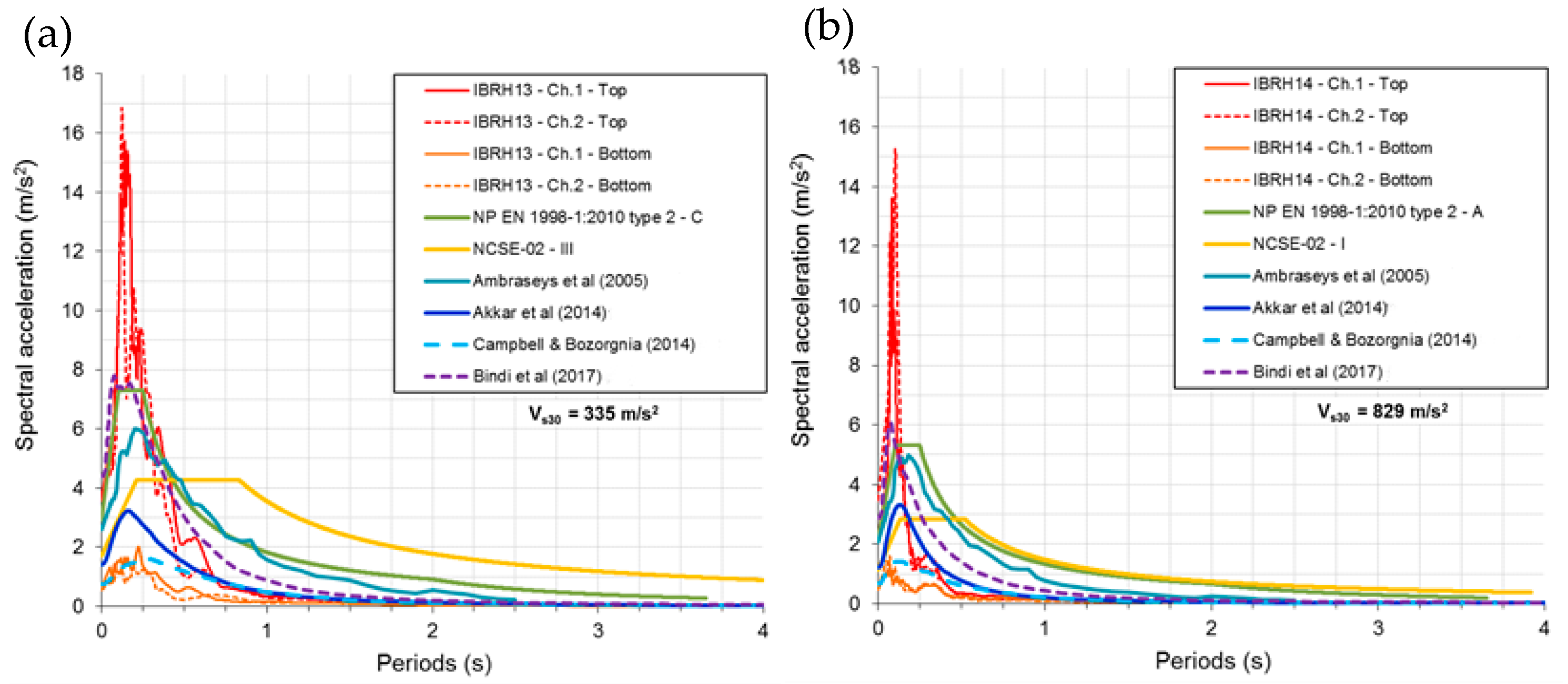
This strategy was also adopted to assess the ability of the implemented GMPEs to reproduce near-field earthquake scenarios (in this case, the GMPEs that were developed for subduction areas were not used). A superficial onshore earthquake that occurred in Japan on 21 September, 2011 (JMA magnitude of 5.2, Mw = 5.1) was selected. This earthquake was recorded in two very close sites of the KiK-net network: the IBRH13 site (Vs30 = 335 m/s, ground type C of the EC8-1, focus distance of 10.8 km) and the IBRH14 site (Vs30 = 829 m/s, ground type A of the EC8-1, focus distance of 10.3 km). These records presented PGA values which are close to the ones obtained in Spain after the 2011 Lorca earthquake [109]. For this scenario, two of the adopted GMPEs use the closest distance to the rupture [100,101]. The other two use the Joyner–Boore distance [98,99]. The comparative results are presented in Figure 11.
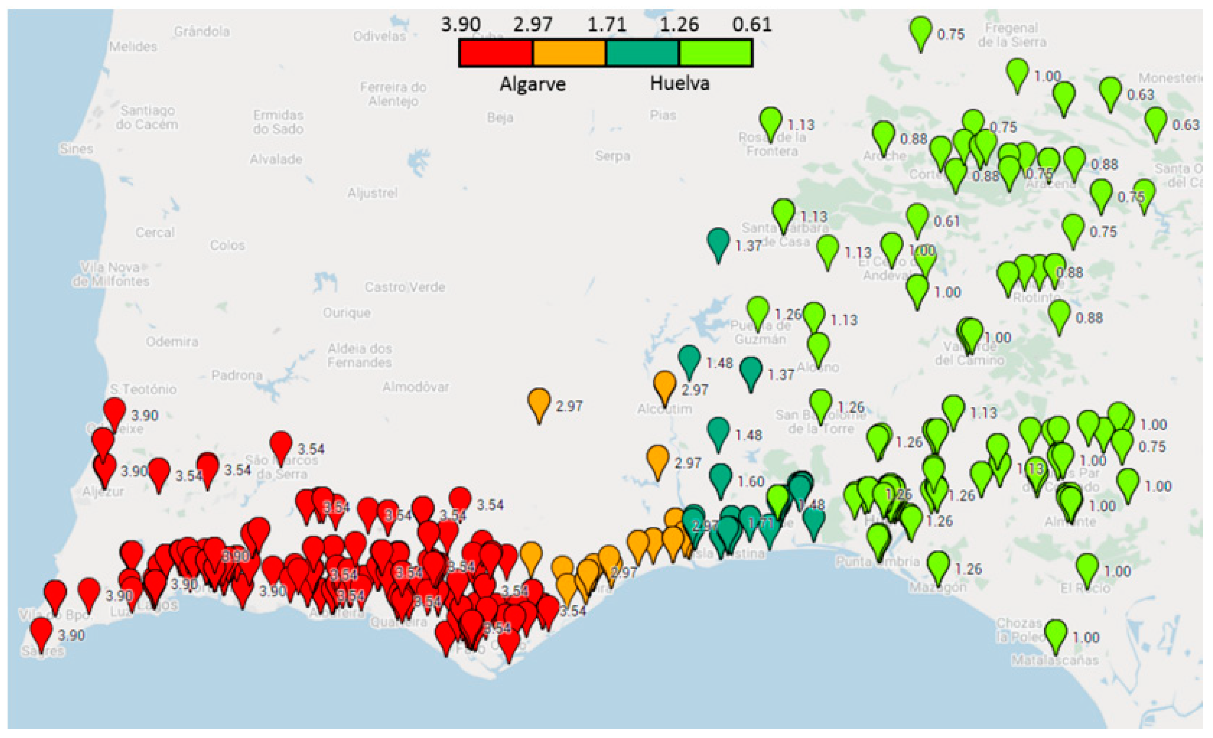
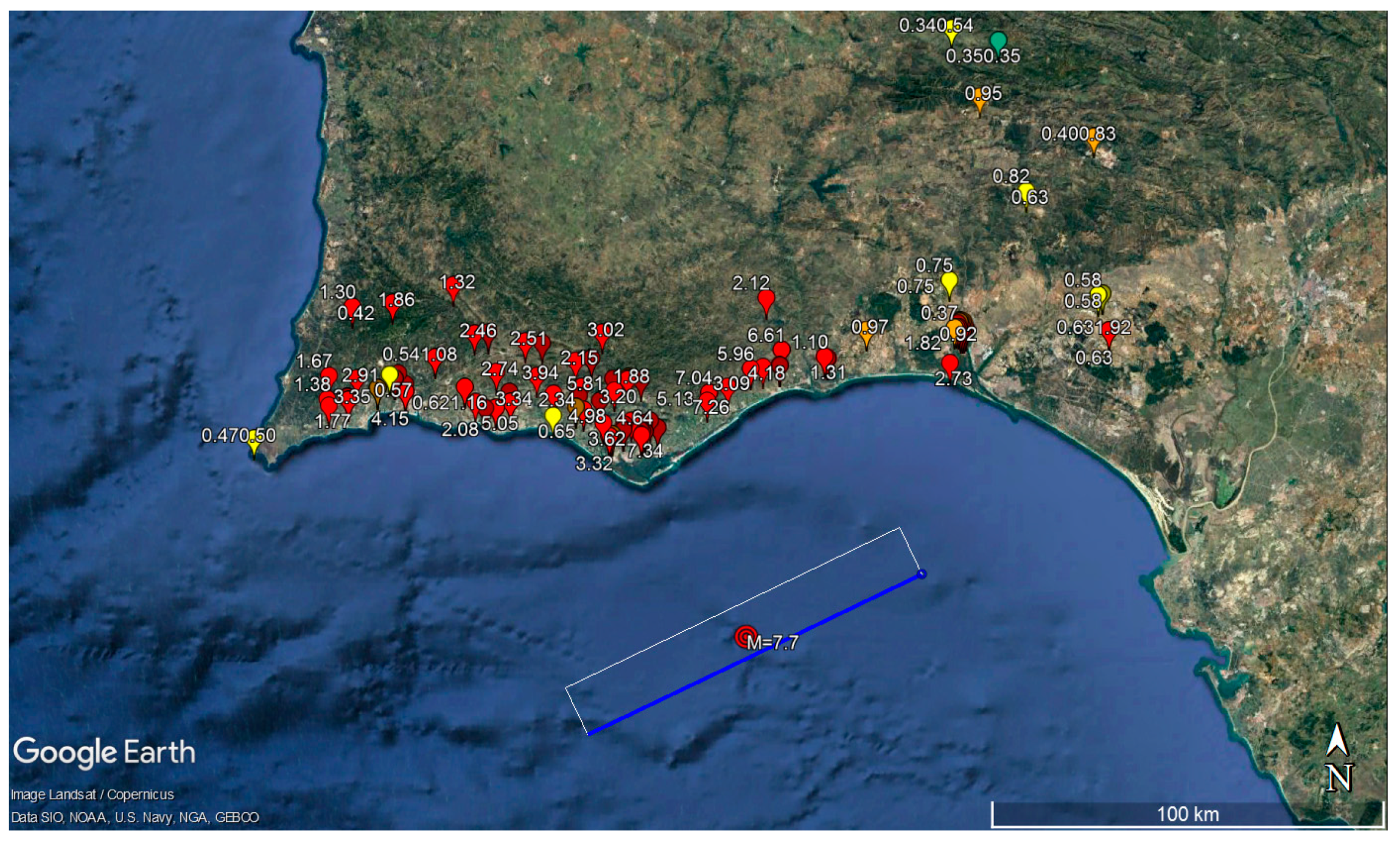
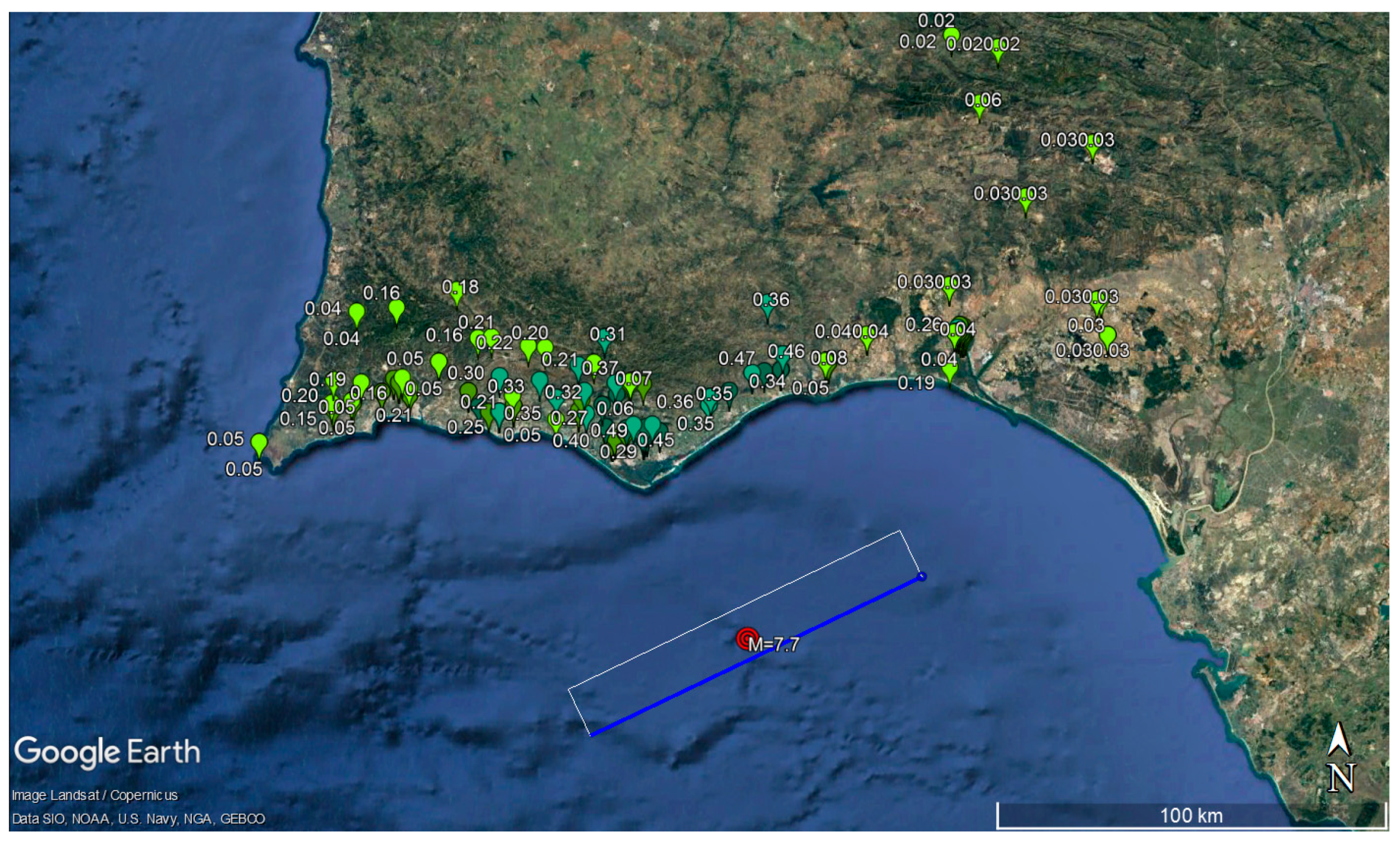
Again, the high dispersion of the results is noticeable when observing the response spectra obtained with different GMPEs. With this issue in mind, it is important to figure out what are the consequences for the damage evaluation that can result from this variation observed in the estimated response spectra. In this context, two GMPEs were adopted for each earthquake scenario, which were the ones that induced the lower and the higher collapse ratios. Figure 12, Figure 13, Figure 14 and Figure 15 show the results obtained for the scenarios that were tested in this work for the LS of NC (a red marker with a number higher than 1.00 means that the collapse of the school building is most likely to occur).
The damage maps obtained for the different earthquake scenarios are probably value information. It emphasises the importance of transmitting to society that a huge amount of uncertainty still exists in relation to the occurrence of earthquakes, with regard to their recurrence, the propagation of seismic waves, the phenomena of local amplification or their effects on buildings. Interestingly, the GMPE that presents the highest values for the near-field onshore earthquake is also the one that has the lowest values for the far-field offshore earthquake scenario. The damage that schools would effectively present due to the earthquake scenarios that were studied would probably fall between the upper and lower limits of the results shown in Figure 12, Figure 13, Figure 14 and Figure 15, where the presented collapse ratio was computed for the LS of NC by using Equation (2).
The enormous uncertainty inherent in seismic risk assessment procedures is observed in the results obtained in this study. For this reason, it is important to transmit this uncertainty to society and to promote a culture of risk. This is probably the only way we can build a more resilient and sustainable society. The importance of this issue was also very evident in Japan after the 2011 Tohoku earthquake, as has been highlighted by some authors [110,111].
In the context of the Algarve and Huelva regions, it is important to remember the destruction caused by the 1755 earthquake [89]. The Algarve was the most damaged region [112]. This is a recurrent phenomenon in this area, as there are sedimentary, palaeontological and geomorphological records of tsunamis of similar effects to the 1755 earthquake [113], as well various historical accounts of different destructive earthquakes [90]. The only way to reduce this uncertainty is to obtain records of large-magnitude earthquakes. These must be recorded at different distances from the source and with different geological characteristics, which unfortunately do not exist in sufficient numbers in this region. Even using stochastic earthquake simulation [44,107], where it is possible to control many of these factors, uncertainty is also high, and the processing speed is much lower than that resulting from the use of GMPEs, which can make their use unrealistic in software intended for civil protection.
The influence of uncertainty surrounding damage seems to be greater for large-magnitude far-field offshore earthquake scenarios, as it influences the results of a greater number of buildings. In relation to scenarios with near-field earthquakes (with lower magnitudes), the differences are less significant and influence the damage results of a smaller number of buildings.
For new buildings, the adoption of capacity design rules intends to solve the problem of aleatory and epistemic uncertainty inherent to the effects of earthquakes on constructions, such as the case of the rules presented in the EC8-1, for example. This type of structural design strategy has long been adopted as a way of desensitising the structural behaviour of the earthquake characteristics [114]. However, in the context of the assessment of existing buildings, the influence of the variability of the seismic action is still an important problem that needs to be minimised. Recent seismic hazard studies have adopted backbone approaches to capture the epistemic uncertainty, namely, by combining a set of GMPEs within logic trees [52,115]. However, there are also issues related to this approach, because sensitivity studies have shown that the selection of GMPEs has a greater impact on the results than the weights assigned to each branch of the logic trees [116]. If all branches are given an equal weight, this is equivalent to the mere arithmetic mean, which may not be the best option, given the difference in results observed in the response spectra presented in Figure 10 and Figure 11. It is also not certain that these weights are equally valid for all magnitudes and distances, namely, in the context of the region under study. Moreover, it is likely that the set of GMPEs, as well as the weights of the logic trees, should be properly adjusted for each particular region, instead of being uniform for large areas.
In all the tested scenarios, it was the masonry school buildings that had the highest school score in terms of possible collapse. Therefore, buildings with this structural system are the ones where seismic retrofitting measures are most needed, which was the support for selecting the two pilot school buildings that were retrofitted.
In relation to the differences observed between the seismic actions that are stipulated on each side of the border between Portugal and Spain, it will be necessary to carry out more studies. These should be of a probabilistic nature, to better define the seismic action for the border zone between these two countries.
In this context, this type of study should be continued for this region, transcending country borders, which is of utmost importance to increase the resilience of the communities, as the effects of the earthquakes do not recognise international borders, which should be reflected in the future generation of EC8.

6. Conclusions

As a result of the work carried out in the PERSISTAH project, it is possible to present the following main conclusions:
  • It is feasible to carry out the evaluation of the seismic safety of a large number of buildings using the analysis methods established in the EC8-3, when using dedicated software, such as the one that was developed for the project;
  • Using this approach, it has been possible to verify the great influence of the selection of the GMPEs on the estimation of the collapse ratio of the school buildings. Therefore, the real degree of damage expected for the earthquake scenarios tested is not certain. Nevertheless, it would probably be within the upper and lower limits obtained;
  • The seismic retrofitting of two pilot schools made it possible to observe the main execution errors of the most usual solutions adopted for masonry buildings. Moreover, it stressed the need to provide training courses to all types of workers involved in this type of work and not to just focus attention on structural designers;
  • The resources and educational material developed, as well as the training actions carried out with teachers, were a great success. This shows that this procedure is one of the best ways to create a more resilient society to the effects of earthquakes;
  • The PERSISTAH project can help government agencies to prepare a vulnerability reduction plan, promoting structural and non-structural mitigation, to enhance the safety of existing schools and reduce their vulnerability;
  • The fact that PERSISTAH is a cross-border project allowed a better understanding of the differences between the seismic codes of Portugal and Spain, in particular for school buildings. Therefore, it is desirable to carry out more joint studies concerning the seismic hazard of these regions.

Author Contributions

Conceptualisation and methodology, J.M.C.E., A.M.-E., L.F.S., M.A.F. and C.S.O.; software, J.M.C.E.; validation, J.M.C.E.; formal analysis, J.M.C.E., B.T., C.E., V.B., M.-V.R.-G.-C., E.R.-S., J.d.-M.-R. and M.-L.S.-V.; investigation, J.M.C.E., A.M.-E., M.A.F., M.-V.R.-G.-C., E.R.-S., J.d.-M.-R., M.-L.S.-V. and B.Z.B.; resources, J.M.C.E., A.C., L.F.S., A.B., M.A.F., M.-V.R.-G.-C., E.R.-S. and J.d.-M.-R.; writing—original draft preparation, J.M.C.E., A.M.-E., M.-V.R.-G.-C., E.R.-S. and B.Z.B.; writing—review and editing, J.M.C.E., A.M.-E., M.-V.R.-G.-C., M.A.F. and C.S.O.; supervision, J.M.C.E., A.M.-E. and C.S.O.; project administration, J.M.C.E., A.M.-E. and L.F.S.; funding acquisition, J.M.C.E., A.M.-E., L.F.S., M.A.F. and C.S.O. All authors have read and agreed to the published version of the manuscript.

Funding

This research was funded by the INTERREG-POCTEP España–Portugal programme and the European Regional Development Fund through the 0313_PERSISTAH_5_P project.

Institutional Review Board Statement

Not applicable.

Informed Consent Statement

Not applicable.

Data Availability Statement

All detailed information about the PERSISTAH project can be found at the following link: https://sites.google.com/view/persistah/en, accessed on 30 October 2022.

Acknowledgments

The authors wish to thank the Municipalities of the Algarve that have contributed to this project, in particular the Municipality of Olhão, the General Directorate for Schools (Algarve Region Service Directorate of Faro), and the Portuguese General Secretariat of the Ministry of Education and Science of Lisbon, for providing information and architectural drawings of some school buildings. The first author would also like to acknowledge the financial support of the Portuguese Foundation of Science and Technology (FCT) of CIMA through UIDP/00350/2020.

Conflicts of Interest

The authors declare no conflict of interest. The funders had no role in the design of the study; in the collection, analyses, or interpretation of data; in the writing of the manuscript, or in the decision to publish the results.

References

  1. UN. The 17 Sustainable Development Goals (SDGs). United Nations. Available online: https://sdgs.un.org/goals (accessed on 20 December 2021).
  2. Mendonça, D.; Amorim, I.; Kagohara, M. An historical perspective on community resilience: The case of the 1755 Lisbon Earthquake. Int. J. Disaster Risk Reduct. 2019, 34, 363–374. [Google Scholar] [CrossRef]
  3. Winstanley, A.; Hepi, M.; Wood, D. Resilience? Contested meanings and experiences in post-disaster Christchurch, New Zealand. Kōtuitui N. Z. J. Soc. Sci. Online 2015, 10, 126–134. [Google Scholar] [CrossRef] [Green Version]
  4. Xi, Y.; Yu, H.; Yao, Y.; Peng, K.; Wang, Y.; Chen, R. Post-traumatic stress disorder and the role of resilience, social support, anxiety and depression after the Jiuzhaigou earthquake: A structural equation model. Asian J. Psychiatry 2020, 49, 101958. [Google Scholar] [CrossRef] [PubMed]
  5. Bal, İ.E.; Smyrou, E. Simulation of the earthquake-induced collapse of a school building in Turkey in 2011 Van Earthquake. Bull. Earthq. Eng. 2016, 14, 3509–3528. [Google Scholar] [CrossRef]
  6. Chen, H.; Xie, Q.; Lan, R.; Li, Z.; Xu, C.; Yu, S. Seismic damage to schools subjected to Nepal earthquakes, 2015. Nat. Hazards 2017, 88, 247–284. [Google Scholar] [CrossRef] [Green Version]
  7. Di Ludovico, M.; Digrisolo, A.; Moroni, C.; Graziotti, F.; Manfredi, V.; Prota, A.; Dolce, M.; Manfredi, G. Remarks on damage and response of school buildings after the Central Italy earthquake sequence. Bull. Earthq. Eng. 2019, 17, 5679–5700. [Google Scholar] [CrossRef]
  8. Kabeyasawa, T. Damages to RC school buildings and lessons from the 2011 East Japan earthquake. Bull. Earthq. Eng. 2017, 15, 535–553. [Google Scholar] [CrossRef]
  9. Oyguc, R. Seismic performance of RC school buildings after 2011 Van earthquakes. Bull. Earthq. Eng. 2016, 14, 821–847. [Google Scholar] [CrossRef]
  10. Angelier, J.; Lee, J.-C.; Hu, J.-C.; Chu, H.-T. Three-dimensional deformation along the rupture trace of the September 21st, 1999, Taiwan earthquake: A case study in the Kuangfu school. J. Struct. Geol. 2003, 25, 351–370. [Google Scholar] [CrossRef]
  11. Global_Education_Cluster. Disaster Risk Reduction in Education in Emergencies—A Guidance Note for Education Clusters and Sector Coordination Groups. Available online: https://reliefweb.int/attachments/596e560e-cf6c-3a3c-ab27-576212068dbc/Full_report.pdf (accessed on 5 November 2021).
  12. Calvi, G.M.; Pinho, R.; Magenes, G.; Bommer, J.J.; Restrepo-Vélez, L.F.; Crowley, H. Development of seismic vulnerability assessment methodologies over the past 30 years. ISET J. Earthq. Technol. 2006, 43, 75–104. [Google Scholar]
  13. Maio, R.; Estêvão, J.M.C.; Ferreira, T.M.; Vicente, R. Casting a new light on the seismic risk assessment of stone masonry buildings located within historic centres. Structures 2020, 25, 578–592. [Google Scholar] [CrossRef]
  14. Candeias, P.; Vicente, M.; Rupakhety, R.; Lopes, M.; Ferreira, M.A.; Oliveira, C.S. Seismic Performance of Non-structural Elements Assessed Through Shake Table Tests: The KnowRISK Room Set-Up. In Proceedings of the International Conference on Earthquake Engineering and Structural Dynamics, Cham, Iceland, 12–14 June 2017; pp. 293–307. [Google Scholar] [CrossRef]
  15. Mutch, C. The role of schools in disaster preparedness, response and recovery: What can we learn from the literature? Pastor. Care Educ. 2014, 32, 5–22. [Google Scholar] [CrossRef]
  16. Mutch, C. Leadership in times of crisis: Dispositional, relational and contextual factors influencing school principals’ actions. Int. J. Disaster Risk Reduct. 2015, 14, 186–194. [Google Scholar] [CrossRef]
  17. Notman, R. Seismic Leadership, Hope, and Resiliency: Stories of Two Christchurch Schools Post-Earthquake. Leadersh. Policy Sch. 2015, 14, 437–459. [Google Scholar] [CrossRef]
  18. Tan, K.T.; Abdul Razak, H.; Lu, D.; Li, Y. Seismic response of a four-storey RC school building with masonry-infilled walls. Nat. Hazards 2015, 78, 141–153. [Google Scholar] [CrossRef]
  19. El-Betar, S.A. Seismic vulnerability evaluation of existing R.C. buildings. HBRC J. 2018, 14, 189–197. [Google Scholar] [CrossRef] [Green Version]
  20. Korkmaz, M.; Ozdemir, M.A.; Kavali, E.; Cakir, F. Performance-based assessment of multi-story unreinforced masonry buildings: The case of historical Khatib School in Erzurum, Turkey. Eng. Fail. Anal. 2018, 94, 195–213. [Google Scholar] [CrossRef]
  21. O’Reilly, G.J.; Perrone, D.; Fox, M.; Monteiro, R.; Filiatrault, A. Seismic assessment and loss estimation of existing school buildings in Italy. Eng. Struct. 2018, 168, 142–162. [Google Scholar] [CrossRef]
  22. Perrone, D.; O’Reilly, G.J.; Monteiro, R.; Filiatrault, A. Assessing seismic risk in typical Italian school buildings: From in-situ survey to loss estimation. Int. J. Disaster Risk Reduct. 2020, 44, 101448. [Google Scholar] [CrossRef]
  23. Pan, H.; Kusunoki, K. Aftershock damage prediction of reinforced-concrete buildings using capacity spectrum assessments. Soil Dyn. Earthq. Eng. 2020, 129, 105952. [Google Scholar] [CrossRef]
  24. Clementi, F.; Gazzani, V.; Poiani, M.; Lenci, S. Assessment of seismic behaviour of heritage masonry buildings using numerical modelling. J. Build. Eng. 2016, 8, 29–47. [Google Scholar] [CrossRef]
  25. Hancilar, U.; Çaktı, E.; Erdik, M.; Franco, G.E.; Deodatis, G. Earthquake vulnerability of school buildings: Probabilistic structural fragility analyses. Soil Dyn. Earthq. Eng. 2014, 67, 169–178. [Google Scholar] [CrossRef]
  26. Tang, B.; Lu, X.; Ye, L.; Shi, W. Evaluation of collapse resistance of RC frame structures for Chinese schools in seismic design categories B and C. Earthq. Eng. Eng. Vib. 2011, 10, 369. [Google Scholar] [CrossRef]
  27. Hadzima-Nyarko, M.; Ademović, N.; Krajnović, M. Architectural characteristics and determination of load-bearing capacity as a key indicator for a strengthening of the primary school buildings: Case study Osijek. Structures 2021, 34, 3996–4011. [Google Scholar] [CrossRef]
  28. Karapetrou, S.; Manakou, M.; Bindi, D.; Petrovic, B.; Pitilakis, K. “Time-building specific” seismic vulnerability assessment of a hospital RC building using field monitoring data. Eng. Struct. 2016, 112, 114–132. [Google Scholar] [CrossRef] [Green Version]
  29. Trevlopoulos, K.; Guéguen, P. Period elongation-based framework for operative assessment of the variation of seismic vulnerability of reinforced concrete buildings during aftershock sequences. Soil Dyn. Earthq. Eng. 2016, 84, 224–237. [Google Scholar] [CrossRef]
  30. Shamsoddini Motlagh, Z.; Raissi Dehkordi, M.; Eghbali, M.; Samadian, D. Evaluation of seismic resilience index for typical RC school buildings considering carbonate corrosion effects. Int. J. Disaster Risk Reduct. 2020, 46, 101511. [Google Scholar] [CrossRef]
  31. Chrysostomou, C.Z.; Kyriakides, N.; Papanikolaou, V.K.; Kappos, A.J.; Dimitrakopoulos, E.G.; Giouvanidis, A.I. Vulnerability assessment and feasibility analysis of seismic strengthening of school buildings. Bull. Earthq. Eng. 2015, 13, 3809–3840. [Google Scholar] [CrossRef] [Green Version]
  32. Samadian, D.; Ghafory-Ashtiany, M.; Naderpour, H.; Eghbali, M. Seismic resilience evaluation based on vulnerability curves for existing and retrofitted typical RC school buildings. Soil Dyn. Earthq. Eng. 2019, 127, 105844. [Google Scholar] [CrossRef]
  33. Sobaih, M.E.; Nazif, M.A. A proposed methodology for seismic risk evaluation of existing reinforced school buildings. HBRC J. 2012, 8, 204–211. [Google Scholar] [CrossRef]
  34. Figueroa, E.A.P.; Malisan, P.; Grimaz, S. Implementation of seismic assessment of schools in El Salvador. Int. J. Disaster Risk Reduct. 2020, 45, 101449. [Google Scholar] [CrossRef]
  35. Grimaz, S.; Malisan, P. Multi-hazard visual inspection for defining safety upgrading strategies of learning facilities at territorial level: VISUS methodology. Int. J. Disaster Risk Reduct. 2020, 44, 101435. [Google Scholar] [CrossRef]
  36. Chen, C.-S.; Cheng, M.-Y.; Wu, Y.-W. Seismic assessment of school buildings in Taiwan using the evolutionary support vector machine inference system. Expert Syst. Appl. 2012, 39, 4102–4110. [Google Scholar] [CrossRef]
  37. Chen, H.-M.; Kao, W.-K.; Tsai, H.-C. Genetic programming for predicting aseismic abilities of school buildings. Eng. Appl. Artif. Intell. 2012, 25, 1103–1113. [Google Scholar] [CrossRef]
  38. Kao, W.-K.; Chen, H.-M.; Chou, J.-S. Aseismic ability estimation of school building using predictive data mining models. Expert Syst. Appl. 2011, 38, 10252–10263. [Google Scholar] [CrossRef]
  39. Chuang, M.-C.; Liao, E.; Lai, V.P.; Yu, Y.-J.; Tsai, K.-C. Development of PISA4SB for Applications in the Taiwan School Building Seismic Retrofit Program. Procedia Eng. 2011, 14, 965–973. [Google Scholar] [CrossRef] [Green Version]
  40. D’Ayala, D.; Galasso, C.; Nassirpour, A.; Adhikari, R.K.; Yamin, L.; Fernandez, R.; Lo, D.; Garciano, L.; Oreta, A. Resilient communities through safer schools. Int. J. Disaster Risk Reduct. 2020, 45, 101446. [Google Scholar] [CrossRef]
  41. UN. International Strategy for Disaster Reduction Hyogo Framework for Action 2005–2015: Building the Resilience of Nations, 1st ed.; United Nations: Geneva, Switzerland, 2007. [Google Scholar]
  42. UN. Sendai Framework for Disaster Risk Reduction 2015–2030. Third UN World Conference on Disaster Risk Reduction, 1st ed.; United Nations: Geneva, Switzerland, 2015. [Google Scholar]
  43. Estêvão, J.M.C. An integrated computational approach for seismic risk assessment of individual buildings. Appl. Sci. 2019, 9, 5088. [Google Scholar] [CrossRef] [Green Version]
  44. Estêvão, J.M.C.; Oliveira, C.S. Point and fault rupture stochastic methods for generating simulated accelerograms considering soil effects for structural analysis. Soil Dyn. Earthq. Eng. 2012, 43, 329–341. [Google Scholar] [CrossRef]
  45. CEN. EN 1998-1:2004; Eurocode 8, Design of Structures for Earthquake Resistance—Part 1: General Rules, Seismic Actions and Rules for Buildings. Comité Européen de Normalisation: Bruxelles, Belgique, 2004; p. 229.
  46. IPQ. NP EN 1998-1; Eurocódigo 8: Projecto de Estruturas Para Resistência aos Sismos. Parte 1: Regras Gerais, Acções Sísmicas e Regras Para Edifícios (in Portuguese). Instituto Português da Qualidade: Caparica, Portugal, 2010; p. 230.
  47. Estêvão, J.M.C.; Tomás, B. Ranking the Seismic Vulnerability of Masonry School Buildings according to the EC8-3 by Using Performance Curves. Int. J. Archit. Herit. 2022, 16, 1699–1714. [Google Scholar] [CrossRef]
  48. Estêvão, J.M.C.; Esteves, C. Nonlinear Seismic Analysis of Existing RC School Buildings: The “P3” School Typology. Buildings 2020, 10, 210. [Google Scholar] [CrossRef]
  49. Esteban, A.M.; Sánchez, E.R.; Blanco, B.Z.; Cruz, M.V.R.G.d.l.; Rodríguez, J.d.M.; Estêvão, J. Schools, Seismicity and Retrofitting; Editorial Universidad de Sevilla: Seville, Spain, 2021; p. 164. [Google Scholar] [CrossRef]
  50. NCSE-02; Norma de Construcción Sismorresistente: Parte General y Edificación. Real Decreto 997/2002 (in Spanish). Ministerio de Fomento de España: Madrid, Spain, 2002.
  51. Woessner, J.; Laurentiu, D.; Giardini, D.; Crowley, H.; Cotton, F.; Grünthal, G.; Valensise, G.; Arvidsson, R.; Basili, R.; Demircioglu, M.B.; et al. The 2013 European Seismic Hazard Model: Key components and results. Bull. Earthq. Eng. 2015, 13, 3553–3596. [Google Scholar] [CrossRef] [Green Version]
  52. Weatherill, G.; Kotha, S.R.; Cotton, F. A regionally-adaptable “scaled backbone” ground motion logic tree for shallow seismicity in Europe: Application to the 2020 European seismic hazard model. Bull. Earthq. Eng. 2020, 18, 5087–5117. [Google Scholar] [CrossRef]
  53. IPQ. NP EN 1998-5; Eurocódigo 8: Projecto de Estruturas Para Resistência aos Sismos. Parte 5: Fundações, Estruturas de Suporte e Aspectos Geotécnicos (in Portuguese). Instituto Português da Qualidade: Caparica, Portugal, 2010; p. 54.
  54. Sousa, M.L.; Campos Costa, A. Ground motion scenarios consistent with probabilistic seismic hazard disaggregation analysis. Application to Mainland Portugal. Bull. Earthq. Eng. 2009, 7, 127–147. [Google Scholar] [CrossRef]
  55. Gràcia, E.; Dañobeitia, J.; Vergés, J.; Bartolomé, R.; Córdoba, D. Crustal architecture and tectonic evolution of the Gulf of Cadiz (SW Iberian margin) at the convergence of the Eurasian and African plates. Tectonics 2003, 22, 1033. [Google Scholar] [CrossRef] [Green Version]
  56. Custódio, S.; Dias, N.A.; Carrilho, F.; Góngora, E.; Rio, I.; Marreiros, C.; Morais, I.; Alves, P.; Matias, L. Earthquakes in western Iberia: Improving the understanding of lithospheric deformation in a slowly deforming region. Geophys. J. Int. 2015, 203, 127–145. [Google Scholar] [CrossRef] [Green Version]
  57. IGN. Instituto Geográfico Nacional. Available online: https://www.ign.es (accessed on 25 November 2021).
  58. Custódio, S.; Lima, V.; Vales, D.; Cesca, S.; Carrilho, F. Imaging active faulting in a region of distributed deformation from the joint clustering of focal mechanisms and hypocentres: Application to the Azores–western Mediterranean region. Tectonophysics 2016, 676, 70–89. [Google Scholar] [CrossRef]
  59. Wells, D.L.; Coppersmith, K.J. New empirical relationships among magnitude, rupture length, rupture width, rupture area, and surface displacement. Bull. Seismol. Soc. Am. 1994, 84, 974–1002. [Google Scholar]
  60. CEN. EN 1998-3: 2005; Eurocode 8, Design of Structures for Earthquake Resistance—Part 3: Assessment and Retrofitting of Buildings. Comité Européen de Normalisation: Brussels, Belgique, 2005; p. 89.
  61. IPQ. NP EN 1998-3; Eurocódigo 8: Projecto de Estruturas Para Resistência aos Sismos. Parte 3: Avaliação e Reabilitação de Edifícios (in Portuguese). Instituto Português da Qualidade: Caparica, Portugal, 2017; p. 230.
  62. Lagomarsino, S.; Penna, A.; Galasco, A.; Cattari, S. TREMURI program: An equivalent frame model for the nonlinear seismic analysis of masonry buildings. Eng. Struct. 2013, 56, 1787–1799. [Google Scholar] [CrossRef]
  63. Barreto, V.; Estêvão, J.M.C. Feasibility of Using Steel Bracings for Seismic Retrofitting of RC School Buildings. In Proceedings of the INCREaSE 2019; Springer: Cham, Switzerland, 2019; pp. 1117–1127. [Google Scholar] [CrossRef]
  64. Seismosoft. SeismoStruct 2016 Release-1—A Computer Program for Static and Dynamic Nonlinear Analysis of Framed Structures. 2016. Available online: http://www.seismosoft.com (accessed on 29 July 2017).
  65. Estêvão, J.M.C. Feasibility of using neural networks to obtain simplified capacity curves for seismic assessment. Buildings 2018, 8, 151. [Google Scholar] [CrossRef] [Green Version]
  66. IGN. Actualización de Mapas de Peligrosidad Sísmica de España 2012 (in Spanish); Centro Nacional de Información Geográfica (CNIG): Madrid, Spain, 2017. [Google Scholar] [CrossRef]
  67. Segovia-Verjel, M.-L.; Requena-García-Cruz, M.-V.; de-Justo-Moscardó, E.; Morales-Esteban, A. Optimal seismic retrofitting techniques for URM school buildings located in the southwestern Iberian peninsula. PLoS ONE 2019, 14, e0223491. [Google Scholar] [CrossRef] [PubMed]
  68. McKenna, F.; Scott Michael, H.; Fenves Gregory, L. Nonlinear Finite-Element Analysis Software Architecture Using Object Composition. J. Comput. Civ. Eng. 2010, 24, 95–107. [Google Scholar] [CrossRef]
  69. Couto, R.; Requena-García-Cruz, M.V.; Bento, R.; Morales-Esteban, A. Seismic capacity and vulnerability assessment considering ageing effects: Case study—Three local Portuguese RC buildings. Bull. Earthq. Eng. 2021, 19, 6591–6614. [Google Scholar] [CrossRef]
  70. Requena-Garcia-Cruz, M.V.; Romero-Sánchez, E.; Morales-Esteban, A. Numerical investigation of the contribution of the soil-structure interaction effects to the seismic performance and the losses of RC buildings. Dev. Built Environ. 2022, 12, 100096. [Google Scholar] [CrossRef]
  71. Dolce, M.; Speranza, E.; De Martino, G.; Conte, C.; Giordano, F. The implementation of the Italian National Seismic Prevention Plan: A focus on the seismic upgrading of critical buildings. Int. J. Disaster Risk Reduct. 2021, 62, 102391. [Google Scholar] [CrossRef]
  72. Grant, D.N.; Bommer, J.J.; Pinho, R.; Calvi, G.M.; Goretti, A.; Meroni, F. A Prioritization Scheme for Seismic Intervention in School Buildings in Italy. Earthq. Spectra 2007, 23, 291–314. [Google Scholar] [CrossRef]
  73. Ferreira, M. Risco Sísmico em Sistemas Urbanos (in Portuguese). Ph.D. Thesis, Instituto Superior Técnico, Lisboa, Portugal, 2012. [Google Scholar]
  74. Chung, L.-L.; Yang, Y.-S.; Lien, K.-H.; Wu, L.-Y. In situ experiment on retrofit of school buildings by adding sandwich columns to partition brick walls. Earthq. Eng. Struct. Dyn. 2014, 43, 339–355. [Google Scholar] [CrossRef]
  75. Formisano, A.; Iaquinandi, A.; Mazzolani, F.M. Seismic Retrofitting by FRP of a School Building Damaged by Emilia-Romagna Earthquake. Key Eng. Mater. 2014, 624, 106–113. [Google Scholar] [CrossRef]
  76. Huang, C.H.; Chang, W.; Liu, S.H. Seismic Retrofit of a Typical School Building Using Column Jacketing and Supplement Beams. Appl. Mech. Mater. 2014, 501–504, 1556–1559. [Google Scholar] [CrossRef]
  77. Kaltakci, M.Y.; Arslan, M.H.; Yilmaz, U.S.; Arslan, H.D. A new approach on the strengthening of primary school buildings in Turkey: An application of external shear wall. Build. Environ. 2008, 43, 983–990. [Google Scholar] [CrossRef]
  78. Naja, M.K.; Baytiyeh, H. Towards safer public school buildings in Lebanon: An advocacy for seismic retrofitting initiative. Int. J. Disaster Risk Reduct. 2014, 8, 158–165. [Google Scholar] [CrossRef]
  79. Nakano, Y. Seismic rehabilitation of school buildings in Japan. J. Jpn. Assoc. Earthq. Eng. 2004, 4, 218–229. [Google Scholar] [CrossRef] [Green Version]
  80. Seo, H.; Kim, J.; Kwon, M. Optimal seismic retrofitted RC column distribution for an existing school building. Eng. Struct. 2018, 168, 399–404. [Google Scholar] [CrossRef]
  81. Sorace, S.; Terenzi, G. Motion control-based seismic retrofit solutions for a R/C school building designed with earlier Technical Standards. Bull. Earthq. Eng. 2014, 12, 2723–2744. [Google Scholar] [CrossRef]
  82. The World Bank. Making Schools Resilient at Scale: The Case of Japan; Bogaerts, V.R., Kaneda, K.S., Eds.; The Word Bank: Washington, DC, USA, 2016; p. 94. [Google Scholar]
  83. Estêvão, J.; Tomás, B.; Laranja, R.; Braga, A. Seismic Retrofitting of an Existing Masonry School Building: A Case Study in Algarve. In Sustainability and Automation in Smart Constructions; Rodrigues, H., Gaspar, F., Fernandes, P., Mateus, A., Eds.; Springer International Publishing: Cham, Switzerland, 2021; pp. 349–355. [Google Scholar]
  84. Lew, M.; Naeim, F.; Carpenter, L.D.; Youssef, N.F.; Rojas, F.; Saragoni, G.R.; Adaros, M.S. The significance of the 27 February 2010 offshore Maule, Chile earthquake. Struct. Des. Tall Spec. Build. 2010, 19, 826–837. [Google Scholar] [CrossRef]
  85. Sakurai, A.; Sato, T.; Murayama, Y. Impact evaluation of a school-based disaster education program in a city affected by the 2011 great East Japan earthquake and tsunami disaster. Int. J. Disaster Risk Reduct. 2020, 47, 101632. [Google Scholar] [CrossRef]
  86. Ferreira, M.A.; Oliveira, C.S.; Estêvão, J.; Esteban, A.M.; Blanco, B.Z.; Sánchez, E.R.; Rodríguez, J.d.M.; Cruz, M.V.R.G.d.l.; Sá, L. Why Does the Ground Shake? Editorial Universidad de Sevilla: Seville, Spain, 2020; p. 88. [Google Scholar] [CrossRef]
  87. Ferreira, M.A.; Oliveira, C.S.; Estêvão, J.; Esteban, A.M.; Blanco, B.Z.; Sánchez, E.R.; Rodríguez, J.d.M.; Cruz, M.V.R.G.d.l.; Sá, L. Practical Guide for Earthquake Resilient Schools; Editorial Universidad de Sevilla: Seville, Spain, 2020; p. 50. [Google Scholar] [CrossRef]
  88. #ESTUDOEMCASA. Ciências Naturais e Cidadania—7.° e 8.° anos. Atividade sísmica | Aula 23 | 27 min | 23 Abr. 2021. Available online: https://www.rtp.pt/play/estudoemcasa/p7834/e539122/ciencias-naturais-e-cidadania-7-e-8-anos (accessed on 20 December 2021).
  89. Chester, D.K.; Chester, O.K. The impact of eighteenth century earthquakes on the Algarve region, southern Portugal. Geogr. J. 2010, 176, 350–370. [Google Scholar] [CrossRef]
  90. Udías, A. Large Earthquakes and Tsunamis at Saint Vincent Cape before the Lisbon 1755 Earthquake: A Historical Review. Pure Appl. Geophys. 2020, 177, 1739–1745. [Google Scholar] [CrossRef]
  91. Pro, C.; Buforn, E.; Udías, A.; Borges, J.; Oliveira, C.S. Study of the PGV, Strong Motion and Intensity Distribution of the February 1969 (Ms 8.0) Offshore Cape St. Vincent (Portugal) Earthquake Using Synthetic Ground Velocities. Pure Appl. Geophys. 2020, 177, 1809–1829. [Google Scholar] [CrossRef]
  92. Douglas, J.; Edwards, B. Recent and future developments in earthquake ground motion estimation. Earth-Sci. Rev. 2016, 160, 203–219. [Google Scholar] [CrossRef] [Green Version]
  93. Kaklamanos, J.; Baise, L.G.; Boore, D.M. Estimating Unknown Input Parameters when Implementing the NGA Ground-Motion Prediction Equations in Engineering Practice. Earthq. Spectra 2011, 27, 1219–1235. [Google Scholar] [CrossRef]
  94. CESMD. Center for Engineering Strong Motion Data. Available online: https://www.strongmotioncenter.org/ (accessed on 5 November 2021).
  95. Kaiser, A.; Houtte, C.V.; Perrin, N.; McVerry, G.; Cousins, J.; Dellow, S. Characterizing GeoNet strong motion sites: Site metadata update for the 2015 Strong Motion Database. In Proceedings of the NZSEE Conference 2016, Christchurch, New Zealand, 1–3 April 2016; pp. 1–8. [Google Scholar]
  96. Whitney, R. Ground motion processing and observations for the near-field accelerograms from the 2015 Gorkha, Nepal earthquake. Soil Dyn. Earthq. Eng. 2018, 107, 250–263. [Google Scholar] [CrossRef]
  97. Kaklamanos, J.; Baise, L.G. Model Validations and Comparisons of the Next Generation Attenuation of Ground Motions (NGA–West) Project. Bull. Seismol. Soc. Am. 2011, 101, 160–175. [Google Scholar] [CrossRef]
  98. Akkar, S.; Sandıkkaya, M.A.; Bommer, J.J. Empirical ground-motion models for point- and extended-source crustal earthquake scenarios in Europe and the Middle East. Bull. Earthq. Eng. 2014, 12, 359–387. [Google Scholar] [CrossRef] [Green Version]
  99. Ambraseys, N.N.; Douglas, J.; Sarma, S.K.; Smit, P.M. Equations for the Estimation of Strong Ground Motions from Shallow Crustal Earthquakes Using Data from Europe and the Middle East: Horizontal Peak Ground Acceleration and Spectral Acceleration. Bull. Earthq. Eng. 2005, 3, 1–53. [Google Scholar] [CrossRef] [Green Version]
  100. Bindi, D.; Cotton, F.; Kotha, S.R.; Bosse, C.; Stromeyer, D.; Grünthal, G. Application-driven ground motion prediction equation for seismic hazard assessments in non-cratonic moderate-seismicity areas. J. Seismol. 2017, 21, 1201–1218. [Google Scholar] [CrossRef]
  101. Campbell, K.W.; Bozorgnia, Y. NGA-West2 Ground Motion Model for the Average Horizontal Components of PGA, PGV, and 5% Damped Linear Acceleration Response Spectra. Earthq. Spectra 2014, 30, 1087–1115. [Google Scholar] [CrossRef]
  102. Idini, B.; Rojas, F.; Ruiz, S.; Pastén, C. Ground motion prediction equations for the Chilean subduction zone. Bull. Earthq. Eng. 2017, 15, 1853–1880. [Google Scholar] [CrossRef]
  103. Phung, V.-B.; Loh, C.H.; Chao, S.H.; Abrahamson, N.A. Ground motion prediction equation for Taiwan subduction zone earthquakes. Earthq. Spectra 2020, 36, 1331–1358. [Google Scholar] [CrossRef]
  104. NIED. National Research Institute for Earth Science and Disaster Resilience. Available online: https://www.kyoshin.bosai.go.jp/ (accessed on 5 November 2021).
  105. Hirose, F.; Miyaoka, K.; Hayashimoto, N.; Yamazaki, T.; Nakamura, M. Outline of the 2011 off the Pacific coast of Tohoku Earthquake (Mw 9.0)—Seismicity: Foreshocks, mainshock, aftershocks, and induced activity. Earth Planets Space 2011, 63, 1. [Google Scholar] [CrossRef] [Green Version]
  106. Ammon, C.J.; Lay, T.; Kanamori, H.; Cleveland, M. A rupture model of the 2011 off the Pacific coast of Tohoku Earthquake. Earth Planets Space 2011, 63, 33. [Google Scholar] [CrossRef] [Green Version]
  107. Estêvão, J.M.C.; Carvalho, A. The role of source and site effects on structural failures due to Azores earthquakes. Eng. Fail. Anal. 2015, 56, 429–440. [Google Scholar] [CrossRef] [Green Version]
  108. Bulian, F.; Sierro, F.J.; Ledesma, S.; Jiménez-Espejo, F.J.; Bassetti, M.-A. Messinian West Alboran Sea record in the proximity of Gibraltar: Early signs of Atlantic-Mediterranean gateway restriction. Mar. Geol. 2021, 434, 106430. [Google Scholar] [CrossRef]
  109. Cabañas, L.; Alcalde, J.M.; Carreño, E.; Bravo, J.B. Characteristics of observed strong motion accelerograms from the 2011 Lorca (Spain) Earthquake. Bull. Earthq. Eng. 2014, 12, 1909–1932. [Google Scholar] [CrossRef]
  110. Geller, R.J. Shake-up time for Japanese seismology. Nature 2011, 472, 407–409. [Google Scholar] [CrossRef]
  111. Stein, S.; Geller, R.J.; Liu, M. Why earthquake hazard maps often fail and what to do about it. Tectonophysics 2012, 562–563, 1–25. [Google Scholar] [CrossRef]
  112. Teves-Costa, P.; Batlló, J.; Matias, L.; Catita, C.; Jiménez, M.J.; García-Fernández, M. Maximum intensity maps (MIM) for Portugal mainland. J. Seismol. 2019, 23, 417–440. [Google Scholar] [CrossRef]
  113. Lario, J.; Zazo, C.; Goy, J.L.; Silva, P.G.; Bardaji, T.; Cabero, A.; Dabrio, C.J. Holocene palaeotsunami catalogue of SW Iberia. Quat. Int. 2011, 242, 196–200. [Google Scholar] [CrossRef] [Green Version]
  114. Paulay, T.; Priestley, M.J.N. Seismic Design of Reinforced Concrete and Masonry Buildings; John Wiley & Sons, Inc: Hoboken, NJ, USA, 1992. [Google Scholar]
  115. Kowsari, M.; Ghasemi, S. A backbone probabilistic seismic hazard analysis for the North Tehran Fault scenario. Soil Dyn. Earthq. Eng. 2021, 144, 106672. [Google Scholar] [CrossRef]
  116. Sabetta, F.; Lucantoni, A.; Bungum, H.; Bommer, J.J. Sensitivity of PSHA results to ground motion prediction relations and logic-tree weights. Soil Dyn. Earthq. 2005, 25, 317–329. [Google Scholar] [CrossRef]
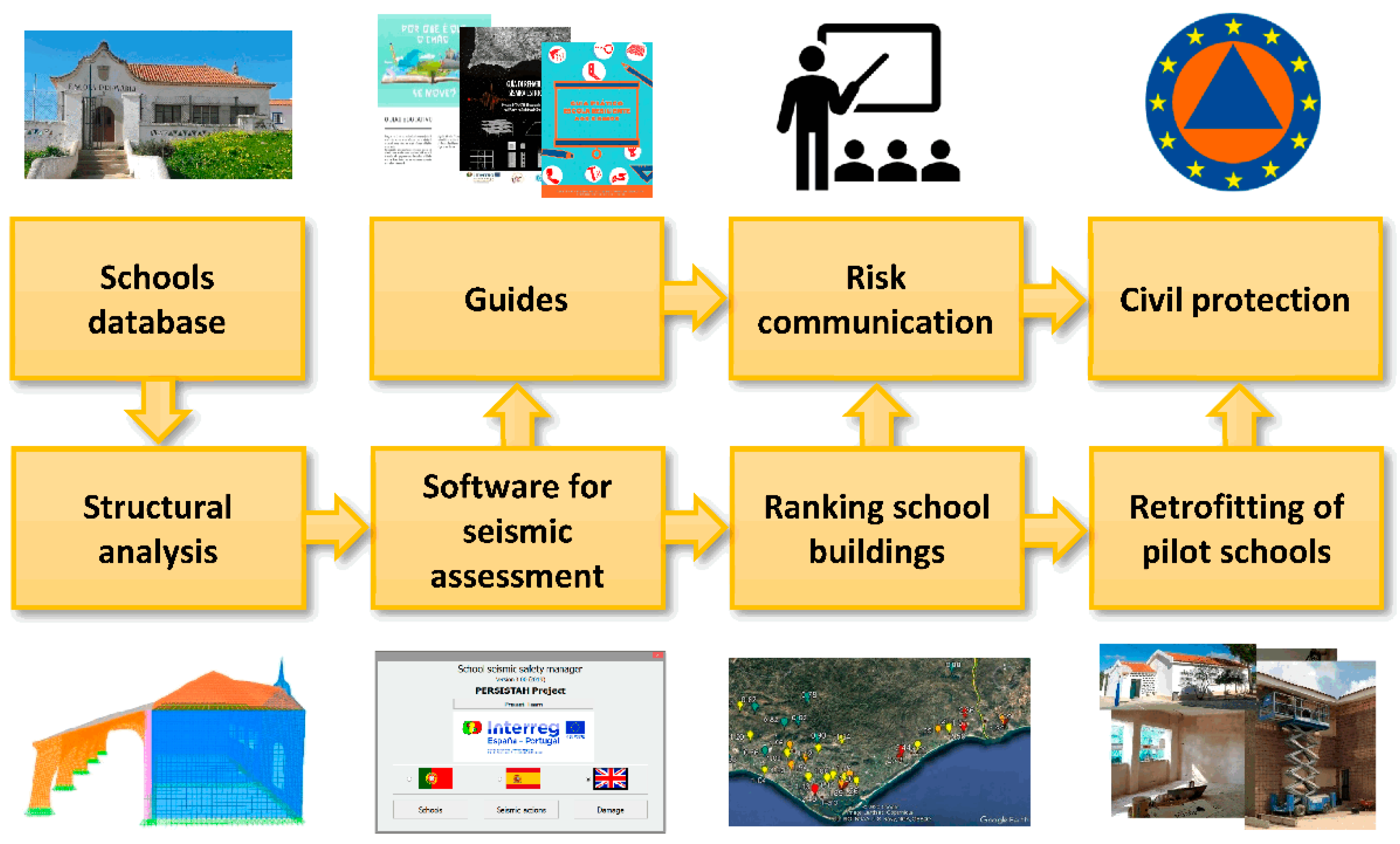
Figure 1. Flowchart of the PERSISTAH project approach and some inputs–outputs.
Sustainability 14 15976 g001
Figure 2. Global organisation of the PERSISTAH project software.
Sustainability 14 15976 g002
Figure 3. Values of ag that are established in national codes for the primary school buildings placed in the regions of the Algarve and Huelva (range between a maximum 3.90 m/s2, in the Algarve region, and a minimum 0.61 m/s2 in the Huelva region). At the border, the discontinuity is from 2 to 1.
Sustainability 14 15976 g003
Figure 4. Earthquake scenario with magnitude M = 7.7 located in a possible offshore source [55]. This is identified near the border between the Algarve (left side of yellow border line) and Huelva (right side of yellow border line) regions.
Sustainability 14 15976 g004
Figure 5. Earthquake scenario with magnitude M = 5.2 near the borderline (in yellow) between the Algarve (left side) and Huelva (right side) regions. It has the same epicentre as the 20 of December of 1989 earthquake (M = 5.0) according to the IGN catalogue.
Sustainability 14 15976 g005
Figure 6. Retrofitting solution that was adopted at the Brancanes primary school (Olhão, Algarve, Portugal).
Sustainability 14 15976 g006
Figure 7. Long façade after retrofitting.
Sustainability 14 15976 g007
Figure 8. Construction detail of the reinforcement used.
Sustainability 14 15976 g008
Figure 9. Activity carried out with the teachers based on the educational guide Why does the ground shake?
Sustainability 14 15976 g009
Figure 10. Comparison of the response spectra obtained with several GMPEs for the offshore scenario, the Japan earthquake records (Mw = 7.8), and the seismic actions of the Portuguese (type 1 of the NP EN 1998-1:2010 [46] for Vila Real de Santo António) and for the Spanish (NCSE-02 [50] for Ayamonte) seismic codes, which are currently mandatory for each region: (a) for the CHBH14 site (ground type C) and (b) for the IBRH18 site (ground type B) [100,101,102,103].
Sustainability 14 15976 g010
Figure 11. Comparison of the response spectra obtained with several GMPEs for the near-source scenario, the Japan earthquake records (Mw = 5.1), and the seismic actions of the Portuguese (type 2 of the NP EN 1998-1:2010 [46] for Vila Real de Santo António) and Spanish (NCSE-02 [50] for Ayamonte) seismic codes, which are currently mandatory for each region: (a) for IBRH13 site (ground type C) and (b) for the IBRH14 site (ground type A) [98,99,100,101].
Sustainability 14 15976 g011
Figure 12. Collapse ratios for the studied offshore earthquake scenario (M = 7.7) when using the Idini et al. GMPE [102].
Sustainability 14 15976 g012
Figure 13. Collapse ratios for the studied offshore earthquake scenario (M = 7.7) when using the Bindi et al. GMPE [100].
Sustainability 14 15976 g013
Figure 14. Collapse ratios for the studied near-field earthquake scenario (M = 5.2) when using the Bindi et al. GMPE [100].
Sustainability 14 15976 g014
Figure 15. Collapse ratios for the studied near-field earthquake scenario (M = 5.2) when using the Campbell and Bozorgnia GMPE [101].
Sustainability 14 15976 g015
Publisher’s Note: MDPI stays neutral with regard to jurisdictional claims in published maps and institutional affiliations.