Article

Evaluating Environmental Quality and Its Driving Force in Northeastern China Using the Remote Sensing Ecological Index

1
College of Surveying and Geo-Informatics, North China University of Water Resources and Electric Power, Zhengzhou 450046, China
2
Key Laboratory of Soil and Water Conservation on the Loess Plateau of Ministry of Water Resources, Yellow River Institute of Hydraulic Research, Yellow River Conservancy Commission, Zhengzhou 450003, China
3
School of Geological Engineering and Geomatics, Chang’an University, Xi’an 710054, China
*
Author to whom correspondence should be addressed.
Sustainability 2022, 14(23), 16304; https://doi.org/10.3390/su142316304
Submission received: 10 November 2022 / Revised: 4 December 2022 / Accepted: 5 December 2022 / Published: 6 December 2022

Abstract

:
As one of the three major black soil regions in the world, northeastern China has an important strategic position there. Since the 20th century, the local environment has undergone great changes under the influence of the natural economy, and it is particularly important to quantitatively assess the degree of change. However, there have been few long-term quantitative studies of environmental spatial-temporal variances in the three northeastern provinces. Therefore, in this study, four typical remote sensing indices of the normalized difference vegetation index (NDVI), land surface temperature (LST), normalized differential building–soil index (NDBSI) and wetness (WET) were employed to construct the remote sensing ecological index (RSEI) using a principal component analysis (PCA) method based on the Google Earth Engine (GEE) platform in northeastern China. The spatiotemporal variations in the eco-environmental quality were detected using linear slope and M–K test, and the direct and interactive effects of different influencing factors on the RSEI changes during 2000–2020 were explored based on geographic detection. The results show that the interannual variations in the RSEI show a fluctuating upward trend, with an increase percentage of 12.45% in the last two decades, indicating that the ecological quality of northeast China has gradually improved. Furthermore, that the western and eastern Heilongjiang provinces and western Jilin provinces contributed substantially to the improvement of environmental quality, while the environmental quality of Jilin provinces and central Liaoning provinces decreased to varying degrees. Compared with 2000, the area with a fair environmental quality grade had the greatest change, and had decreased by 60.69%. This was followed by the area with an excellent quality grade, which increased by 117%. Land-use type had the greatest impact on environmental changes in northeastern China, but the impact degree gradually decreased, while the impact of socioeconomic factors such as the gross production of agriculture, forestry, animal husbandry and fishery and population density on environmental quality gradually increased. The major reason for the decline of environmental quality in central Jilin and central Liaoning is that urbanization development had occupied a large amount of cropland. This shows that taking into account the virtuous cycle of an ecological environment while promoting urban and rural development may be an important task for northeastern China in the future.

1. Introduction

Comprising a major agricultural region in China, the three northeastern provinces have a unique geography and rich natural resources, are important food production areas, and are a key area of concern for the Chinese government in terms of ecological protection and conservation of soil and water [1]. It is of great significance for sustainable utilization of the natural resources and the protection of the ecological environment that ecological and environmental quality assessments in northeastern China are carried out.
In previous studies, a single environmental factor was often used to evaluate the ecosystem, for example, the normalized difference vegetation index (NDVI) was used to assess the response of plant productivity to climate variability [2], net primary productivity (NPP) was used to monitor phytoplankton growth [3], and the leaf area index (LAI) was used to represent land greening characteristics [4]. However, the ecological environment is affected by various factors (e.g., temperature, precipitation and radiation), so it is difficult to use a single index to describe the comprehensive characteristics of the ecological environment. Therefore, scholars have proposed some models that use multiple indicators to comprehensively evaluate ecological conditions. The commonly used methods to evaluate and analyze regional ecological environments include the pressure–state–response (PSR) framework [5] and the fuzzy analytic hierarchy process (FAHP) [6]. However, defects of the above methods are that the weights need to be determined manually and it is difficult to consider the objectivity of the actual problems, thereby reducing the credibility of the results. An ecological environment index (EI) [7] can be used to comprehensively characterize land surface conditions. However, this method needs to combine multiple data sources, and there are still some challenges in obtaining indicators. In 2013, Xu et al. [8] used principle component analysis (PCA) to calculate greenness, heat, dryness and humidity and construct a remote sensing ecological index (RSEI). This method does not need to determine the weight manually, so that the results have a certain objectivity. Since the introduction of RSEI, it has been widely used in various fields due to its advantages, including its easy access to indicators and visualization [9,10]. Based on the RSEI model, Zhang et al. [11] analyzed the interaction mechanism between urban ecological environment quality and urbanization, and concluded that the development of urbanization had been restricted by the ecological environment. These research results provided a new perspective for the study of urban sustainable development. Mohammad et al. [12] took several typical regions in Europe as examples, constructed an RSEI using remote sensing image data sets, established ecosystem models combined with surface biophysical characteristics, and developed a new method to quantify ecological poverty areas on urban surfaces..
In recent years, ecological research in northeastern China has attracted extensive attention from many scholars. For example, Wang et al. [13] took northeast China as an example to construct the classification system and theoretical framework for land use function transfer, and found that the mechanism of land use function transfer is the result of coupling the confrontations between the social-ecological feedback paths guided by policies and the social-economic change paths that are influenced by them. Yu et al. [14] used a double logistic model to extract the phenological variables of vegetation for analysis, and their research results reveal that the continuous warming of the future climate may lead to the shortening of the growth period of grass in semi-arid areas. wang et al. [15] studied 12 black soil profiles in northeastern China, assessed the soil erosion rate, and found that wind erosion was dominant in the west and that water erosion was dominant in the east, which provided suggestions for the rational use of black soil areas, based on the GIMMS NDVI dataset and phenological field observation data. However, research on long-term ecological quality monitoring in the three northeastern provinces is weak, and the feasibility of the RSEI model in the northeastern region needs to be verified. In addition, due to the complexity of the interactions between the ecological environment and the human–land relationship in semi-humid regions, the interaction of natural and social factors on the environment is unclear, and more comprehensive data analysis is needed to improve the feedback and understanding of environmental change drivers in northeast China. In this study, we constructed a remote sensing ecological index (RSEI) based on Google Earth Engine (GEE). By using MODIS products online, the study could avoid the downloading, processing and storage work of traditional methods [16], and important driving factors, including land-use types, precipitation, temperature, altitude, gross industrial production (GDP), population density, and total retail consumption were selected.
The goals of this study were: (1) to construct the RSEI index based on remote sensing data to clarify the temporal and spatial changes of environmental quality in northeastern China from 2000 to 2020, (2) to quantify the degree of change in environmental quality using the Theil–Sen–MK method, and (3) to explore the driving mechanism of regional environmental quality. The research results can provide a scientific basis and theoretical support for the improvement and sustainable development of the ecological environment in the three northeast provinces.

2. Materials and Methods
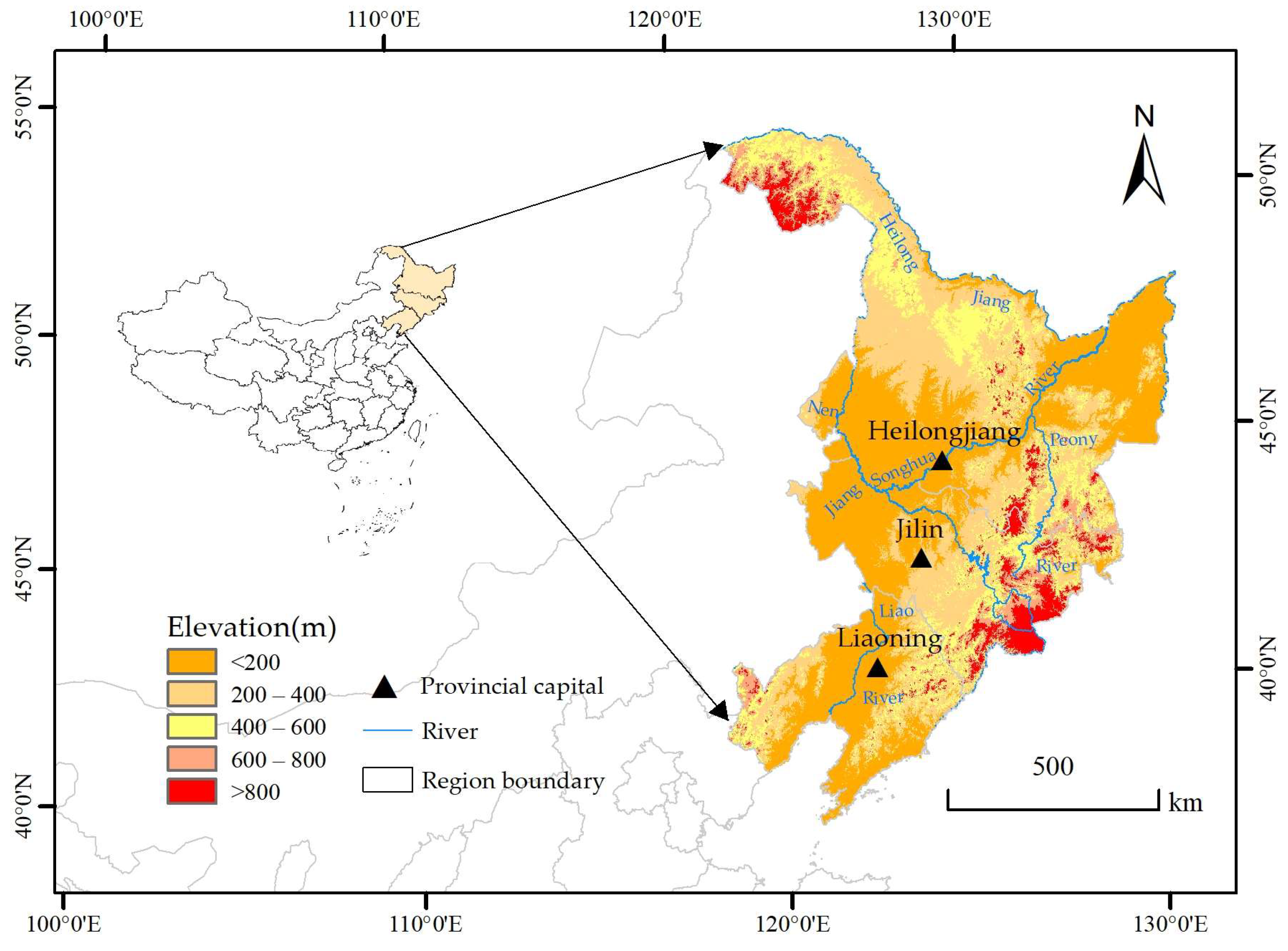
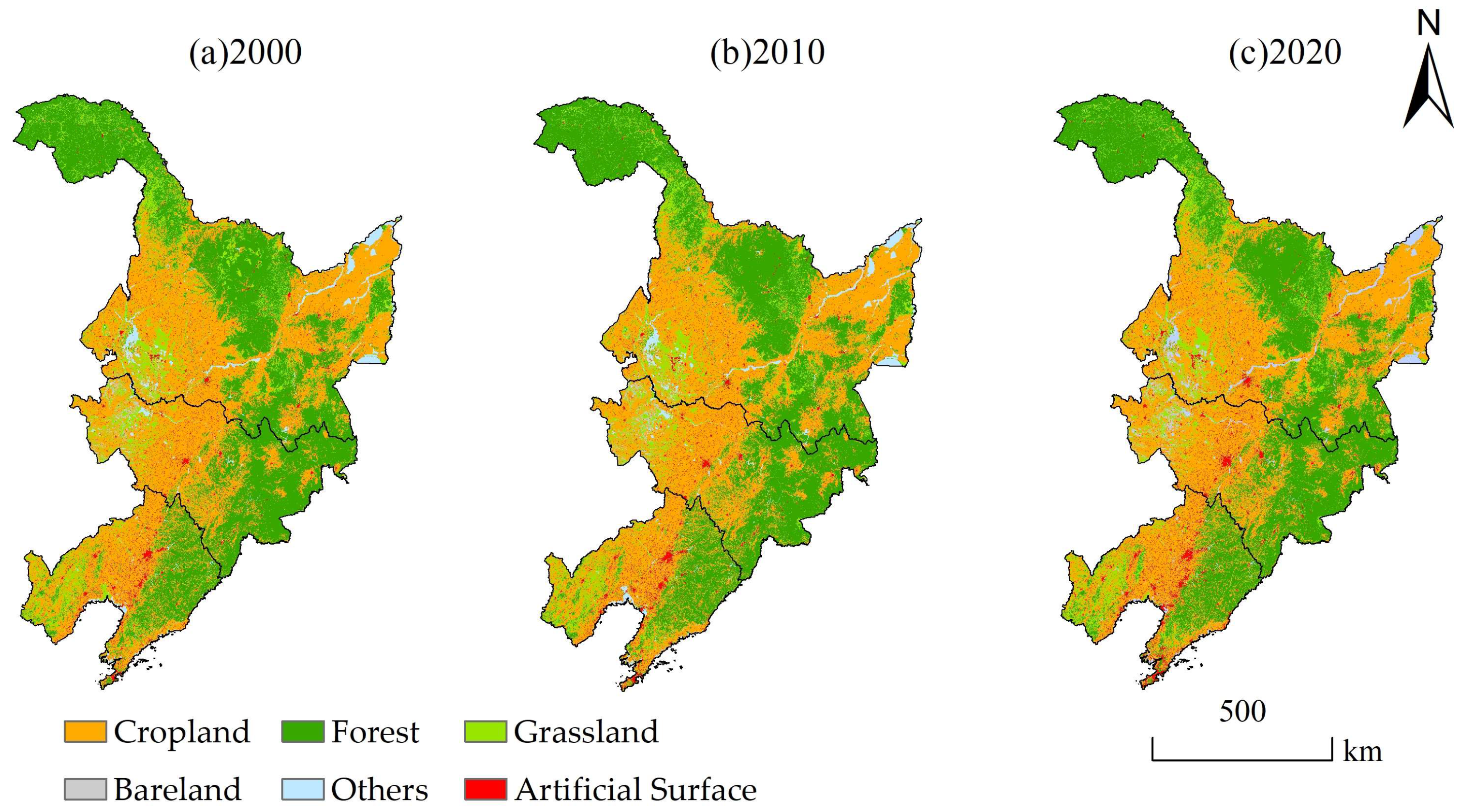
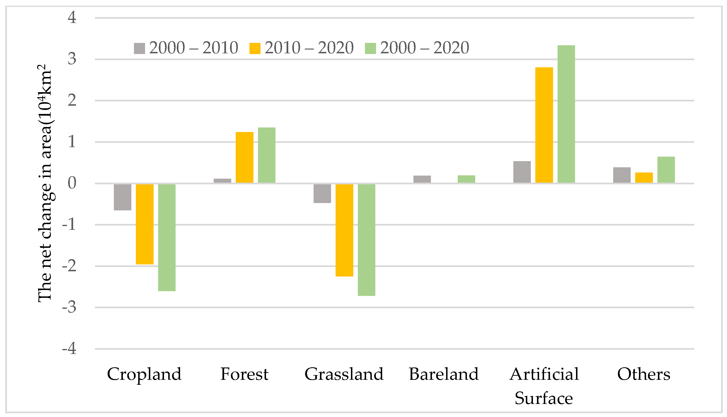
2.1. Study Area

The three northeast provinces (38°46′ N–53°30′ N, 118°53′ E–135°04′ E) are located on the edge of the Asian continent in northeastern China, bordering Bohai Sea to the south and Russia to the north. It covers an area of 787,000 km2, accounting for about 8.19% of China’s land area, including Heilongjiang, Jilin and Liaoning provinces (Figure 1). The climate is characterized by a temperate monsoon climate, which can be divided into humid, semi-humid and semi-arid from southeast to northwest. The average temperature is lowest in January at −24.0 to −9.0 °C and higher in July at 21.0 to 26.0 °C. The annual precipitation ranges from 300 to 1000 mm, mainly concentrated between July and September each year [17]. The terrain is mainly mountains and plains, with Changbai Mountain, Lesser Khingan Mountains and Greater Khingan Mountains in the east, north and west, respectively. The unique natural conditions and resources mean that northeastern China is a region with an important ecological function.

2.2. Data Sources and Preprocessing

Based on the GEE platform, MODIS products with a resolution of 500 m were selected for the vegetation growth season from May to September in 2000–2020 to construct the RSEI (https://modis.gsfc.nasa.gov (accessed on 8 June 2022)). Since this study only focused on the environmental quality assessment of non-water areas, rather than water bodies, the modified normalized difference water index (MNDWI) [18] was used to remove water bodies to avoid the impact of water and snow areas on the environmental assessment. The DEM data with a resolution of 30 m were from the United States Shuttle Radar Topography Mission (SRTM) (http://www.tuxingis.com/ (accessed on 23 June 2022)), the slope and aspect were automatically calculated based on DEM through ArcGIS10.5, and other data are listed in Table 1. For the convenience of analysis, we used ArcGIS10.5 to uniformly resample the resolution of all datasets to 500 m.

2.3. Methods

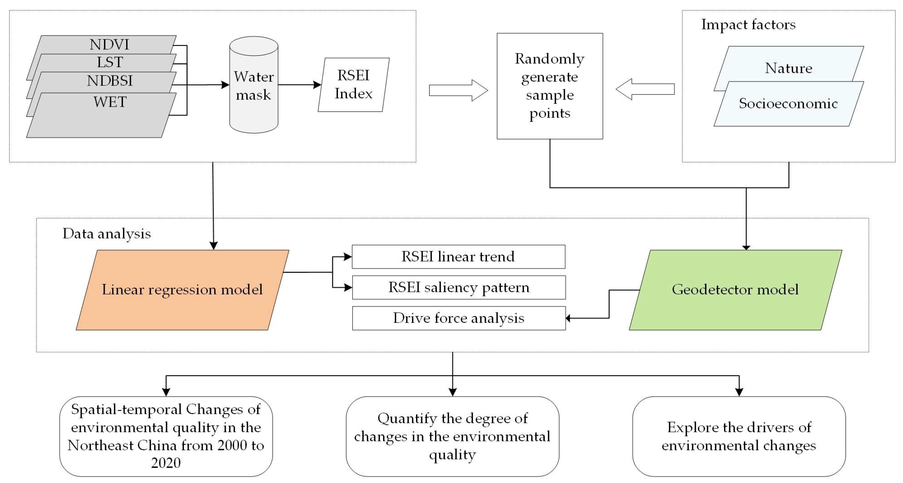
2.3.1. Overall Technical Route

The technical routes of this study (Figure 2).

2.3.2. RSEI Index Construction

NDVI, LST, NDBSI and WET were selected to construct the RSEI by PCA method, and the calculation method of each indicator are listed in Table 2.
Due to the uneven scale of the above indicators, to solve the problem of inconsistent unit dimension, the four indicators need to be normalized. This can be calculated as:
N I i = I i I m i n I m a x I m i n
where N I i denotes the normalized value of an indicator, I i is the original value of pixel i, and I m i n and I m a x represent the minimum and maximum values, respectively.
Principal component analysis (PCA) was used to couple each index, and the initial RSEI 0 (not normalized) was calculated as:
RSEI 0 = 1 PC 1 [ f ( NDVI , LST , NDSI , WET ) ]
PC1 is the first principal component of the four indicators. Similarly, to facilitate the comparison of all indicators, the RSEI index was obtained by normalization processing based on RSEI 0 according to Equation (5). Then we divided the quality grades into five levels, namely bad (0–0.2), Fair (0.2–0.4), medium (0.4–0.6), good (0.6–0.8), and excellent (0.8–1) [24].

2.3.3. Trend Analysis Method

To study the change trend of the eco-environment quality, this study used a linear regression model to fit the RSEI trend of each pixel over time. The unitary linear regression model based on the least square method is a common method in the trend analysis of long time series data [25]. The calculation formula is as follows:
S l o p e = n × i = 1 n i × X i i = 1 n i i = 1 n X i n × i = 1 n i 2 ( i = 1 n i ) 2
where Slope denotes the regression slope of the RSEI index, and n represents the total number of research years, n = 21 in this paper and X i represents the RSEI corresponding to year i. When S l o p e > 0 , it means the improvement of ecological environment quality, otherwise, it means the degradation of ecological environment quality.
The Mann–Kendall method can test the significance of changes in the study parameters without interference from outliers [26]. The calculation formula was calculated as:
S = i = 1 n 1 j = i + 1 n sign ( RSEI j RSEI i )
sign ( RSEI j RSEI i ) = { + 1 RSEI j RSEI i   >   0 0 RSEI j RSEI i   =   0 1 RSEI j RSEI i   <   0
Z = { ( S 1 ) / var ( S ) S   >   0 0 S   =   0 ( S + 1 ) / var ( S ) S   <   0
where i and j denotes the RSEI of year i and year j, respectively, var is the variance, and n is the length of time series. In this paper, the significance test was performed at the significance level α = 0.05 , and when | Z | > 1.96 , the trend is significant.

2.3.4. Driving Mechanism Analysis Method

The geographic detector model is a statistical method to detect spatial differentiation and reveal the driving force behind it [27]. It has been widely used in ecological environments, land cover and other fields [28].The model includes factor detectors that detect the extent to which the independent variable X (driving factor) explains the dependent variable Y (RSEI), calculated as:
q = 1 h = 1 L N h σ h 2 N σ 2
where q is the extent to which the driving factor explains the RSEI, h = 1,…,L, L is the stratification of independent variable X and dependent variable RSEI, N h and N are the number of samples in category h and the whole region, respectively, and σ h 2 , σ 2 are their corresponding sums of variance. The range of q from [0, 1], and the larger q value, the greater influence of this driver on RSEI.
The interaction detector is used to identify whether the interactions between different drivers enhances the explanatory power of the dependent variable RSEI.
This study comprehensively considered the availability and scientificity of factors, selected six natural factors such as the land-use types, precipitation, temperature, elevation, slope and aspect, and four social factors including population density, GDP, total social consumption and retail sales, and gross output value of farming, forestry, animal husbandry and fishery, and quantitatively explored the driving mechanism of environmental quality changes. Then, based on ArcGIS software, the natural discontinuity method was used to discretize each factor and randomly generate 9000 3 km × 3 km grid points, so as to extract the independent and dependent variables corresponding to each grid point, and input them into the geographic detector model. The specific description of influencing factors are listed in Table 3:

3. Results

3.1. PCA Analysis Results

The principal component analysis results of the four indicators in the study area from 2000 to 2020 are listed in Table 4. The contribution rates of the first principal component (PC1) in the three periods were 84.00%, 80.83% and 71.32%, respectively. It can be seen that the PC1 concentrates most of the information characteristics of the four indicators, and that the contribution rate of the four indices to the principal components is relatively stable in different periods. Among these, the NDVI and WET loads were positive, while LST and NDBSI loads were negative, indicating that the role of these two pairs of indices in the ecological environment index is opposite, which was consistent with the actual situation, and shows that it was reasonable to use PCA to construct RSEI.
NDVI is considered to be an effective indicator for the monitoring of terrestrial vegetation changes, one which can quantitatively evaluate regional vegetation cover and growth [29]. The remaining three indicators are directly affected by rainfall and weather, which are important natural factors driving long-term vegetation growth and changes [30]. Their different effects on vegetation may be an important reason why NDVI and WET play a positive role in environmental changes, and NDBSI and LST indices play a negative role.

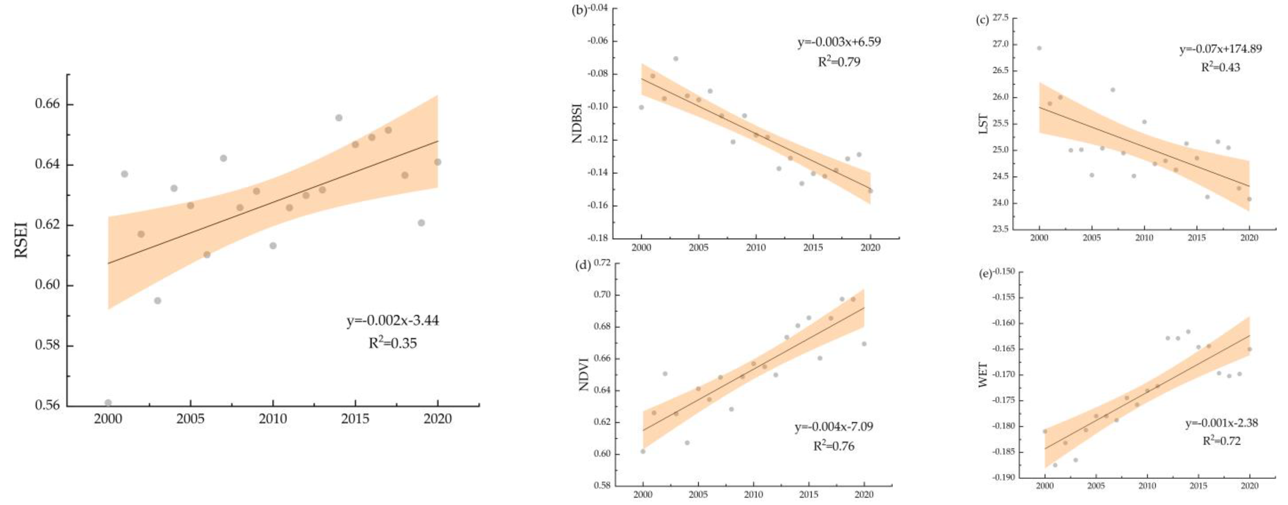
3.2. Annual Variations in the Eco-Environmental Quality in Northeastern China

Figure 3 shows the spatial distribution of interannual changes in the RSEI and Figure 4 shows the annual change trend of the spatial average value RSEI, NDVI, NDBSI and WET during 2000–2020. This shows that the RSEI over the whole of northeastern China has an increasing trend of 0.006/a, with an increase rate of 12.45% from 2000 to 2020. NDVI and WET exhibited an upward trend, increasing by 10.11% and 9.67%, respectively, whereas LST and NDBSI decreased by 11.85% and 33.64%, respectively.
The spatial characteristics of the RSEI showed that the central part clearly increased, and the northern and southern parts decreased to different degrees. In the past 20 years, the RSEI change amplitude in the different province has ranked as follows: Heilongjiang province (0.10) > Jilin province (0.06) > Liaoning province (0.04). The maximum area percentage of RSEI rates of change was concentrated between 0 and 0.002. The significant increase in areas (|Z| > 1.96, Slope > 0) accounted for 30.22% in northeast China, mainly distributed in the west and east of Heilongjiang and the west of Jilin province, while the proportion of the area with a significant decreasing trend was only 6.18%, mainly distributed in the central part of Liaoning and Jilin province.

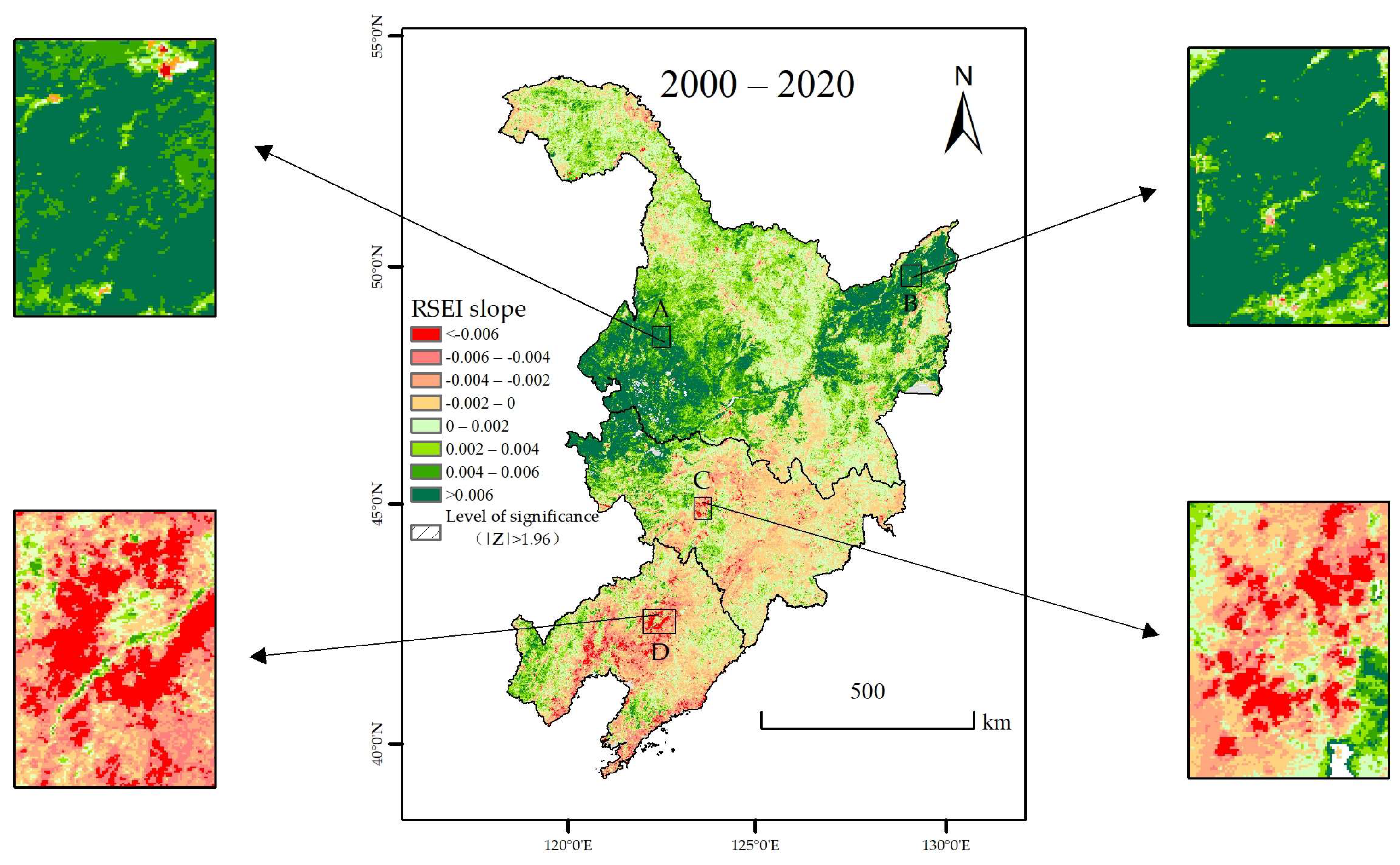
3.3. Spatial-Temporal Evolution Characteristics of Ecological Environmental Quality in Northeastern China

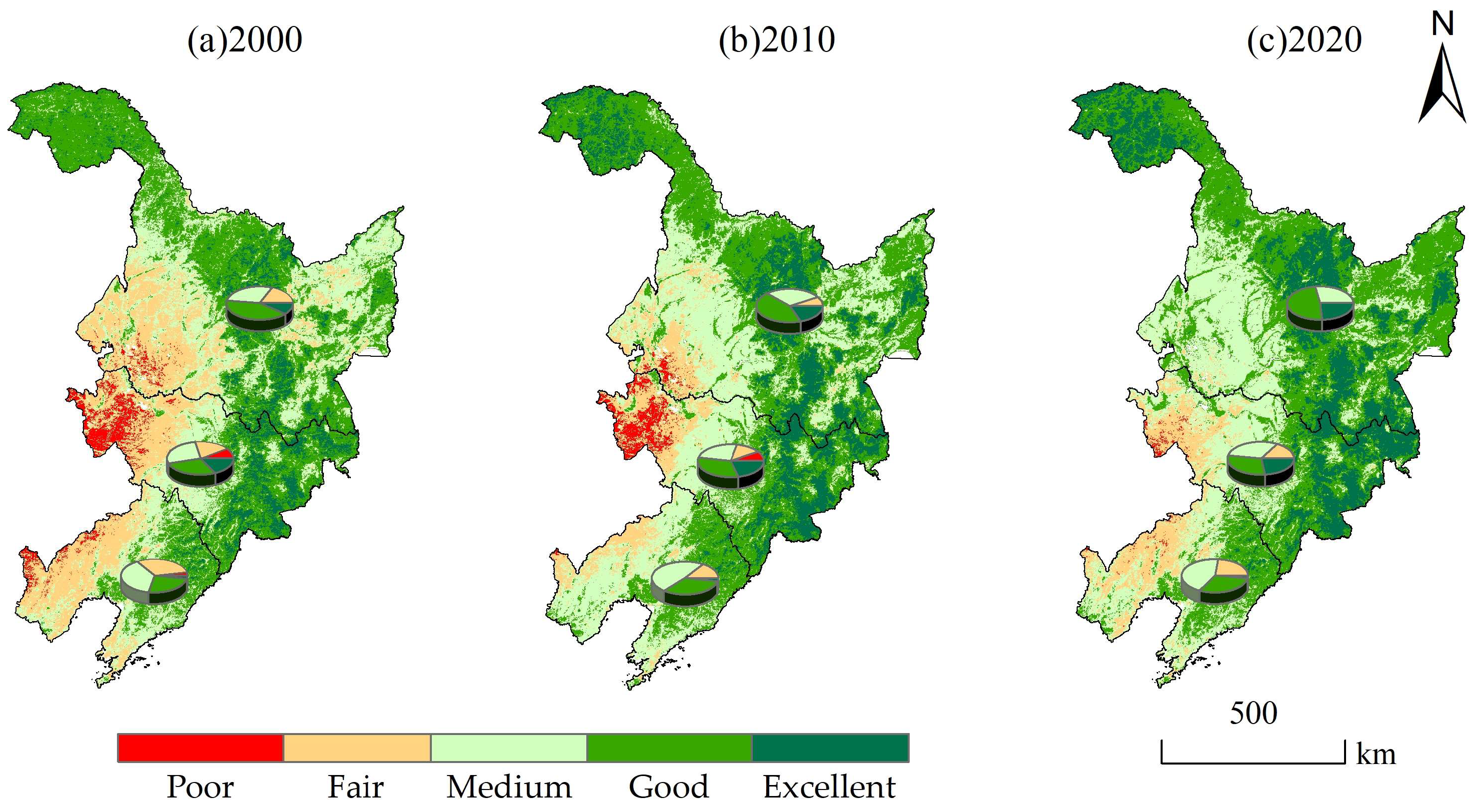
3.3.1. Environmental Quality Grade Structure and Distribution

In 2011, China proposed the National Ecological Protection and Construction Plan (2011–2020) as a national action program for ecological protection and construction. Therefore, this study took 2010 as a key time node and selected the data of 2000, 2010 and 2020 to study the spatial and temporal pattern of environmental changes in the three northeast provinces. The average RSEI in the past three years was 0.561, 0.613 and 0.641, respectively, indicating that the overall quality of the ecological environment has improved. Figure 5 shows the area statistics of environmental quality levels in the three northeastern provinces in 2000, 2010 and 2020, and Figure 6 shows the spatial distribution. The ecological environment quality has clearly changed obviously. Specifically, in 2000, 2010 and 2020, the environmental quality was mainly of good grade, accounting for 37.22%, 39.22% and 40.31% of the area, respectively. In 2000, the area of medium grade was next to that of the good grade (23.86 × 10⁴ km2) at 30.35%. In 2010, the medium grade was still the second largest grade, and the area increased by 2.89 × 10⁴ km2, corresponding to the increase of 12.12%. In 2020, the area of medium grade decreased by 1.69 × 10⁴ km2 compared with 2010. From 2000 to 2020, the area of bad and fair RSEI classes decreased by 1.94 × 10⁴ km2 and 9.91 × 10⁴ km2 respectively, and the other classes increased to different degrees. Among these, the fair grade has the largest change in area, with a decrease of 60.69%, followed by the excellent grade, with an area increase of 8.16 × 10⁴ km2, an increase of 117%. The overall ecological environment quality of the three northeastern provinces exhibited significant improvement.
It can be seen from Figure 6 that the regions with bad and fair environmental quality were concentrated in the central and western parts of the study area, such as the southwest of Heilongjiang province, the west of Jilin province and the west of Liaoning province and were also scattered in the southern region. The special climatic characteristics of these areas make the ecological environment fragile, and human factors such as unreasonable land use and overgrazing also have a certain degree of destructive impact on environmental quality. The medium grade areas were mainly located in midland, including the central Liaoning province, the central Jilin province (adjacent to bad and fair areas), northeast Heilongjiang province, etc. The areas with good and excellent eco-environmental quality were widely distributed, and mainly located in the northern, central and eastern Heilongjiang province, the eastern Jilin province and eastern Liaoning province. These areas have higher altitude, higher intensity of human activities than the western areas, and the land-use types are mainly forest and grassland, which play a good ecological regulation role.

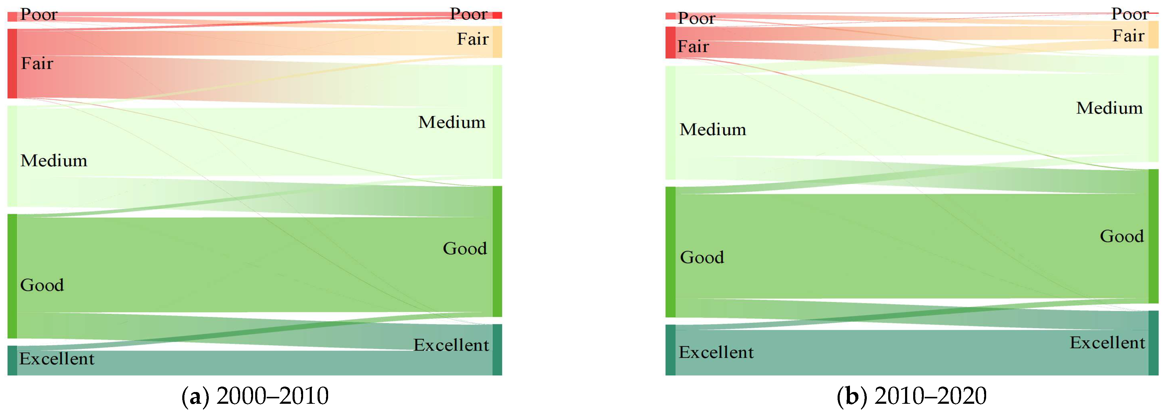
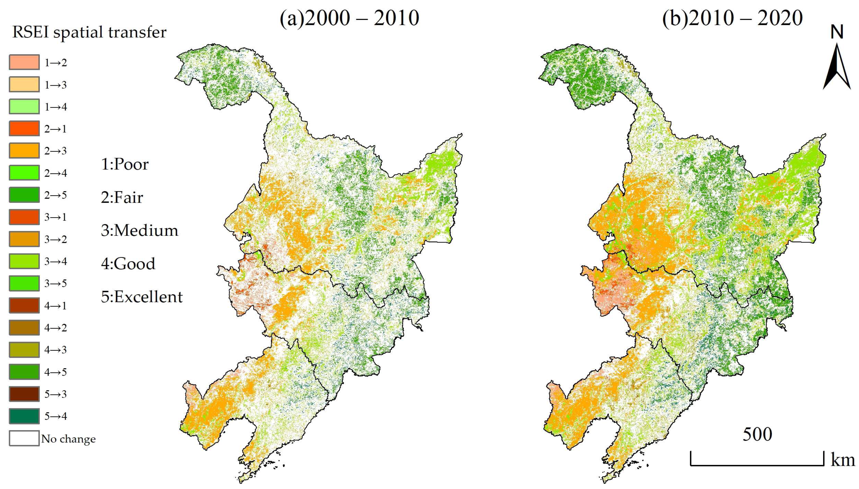
3.3.2. Analysis of Spatial-Temporal Changes in the Quality Grade

To study the hierarchical evolution of ecological environment quality in the three northeastern provinces, the area transfer and spatial distribution of different hierarchical environments are shown in Figure 7 and Figure 8, respectively. The specific analysis is as follows:
According to Figure 7, 0.64 × 10⁴ km 2 was transferred from the bad grade during 2000–2010, of which 92.97% was converted to the fair grade. The area converted from fair grade to medium grade was as high as 9.85 × 10⁴ km 2 , accounting for 92.99%, and the area converted to other grades was less. The area of medium grade has increased, mostly from the fair grade, with the transferred area of 9.85 × 10⁴ km 2 , accounting for 92.01%, followed by the good grade, with a proportion of 7.46%. Among the net area growth with good environmental quality, 84.24% came from medium grade and 13.96% came from excellent grade. The area of excellent grade also increased, it seems specifically that 6.14 × 10⁴ km 2 of good grade was transformed into excellent grade with an area as high as 98.17%, other transfer types included medium grade, with an area of 160.75 km 2 , accounting for 0.03%. It is worth noting that the excellent grade was not converted to bad or fair grade in this period. From 2010 to 2020, the number of areas with bad environmental conditions decreased significantly, and mainly turned out to be of fair grade (1.12 × 10⁴ km 2 ), accounting for 77.41%, followed by medium grade (0.30 × 10⁴ km 2 ), corresponding to a proportion of 21.09%. The area of the bad grade was slightly reduced, and the transferred area was 4.30 × 10⁴  km 2 , of which 90.91% was converted to medium grade, followed by good grade (6.09%). In the medium grade, 5.51 × 10⁴ km 2 was converted to good grade, and 2.10 × 10⁴   km 2 was converted to fair grade. During this period, the area of good grade was mainly converted to excellent grade with an area of 4.45 × 10⁴ km 2 , and then to medium grade with an area of 1.72 × 10⁴ km 2 . The area of excellent grade increased significantly (4.54 × 10⁴ km 2 ), and the proportion from good grade was up to 98.29%.
Figure 8 shows the spatial transfer distribution of RSEI in the three northeastern provinces from 2000 to 2010 and from 2010 to 2020. Since the spatial change patterns of the two periods is similar, they are combined and analyzed together. The region with no change was widely distributed across all provinces. The transfer types of bad grade were mainly fair and medium grade, and were mainly distributed in the west of Jilin province. The areas from fair to medium grade were mainly distributed in the southwest of Heilongjiang province and the west of Liaoning province, and the areas converted to good grades were less. The medium grade to good grade and excellent grade areas were mainly distributed in the northeast Heilongjiang province, central Jilin province and central Liaoning province, and those that became bad and fair grade areas were mainly concentrated in western Jilin province and part of western Heilongjiang province. The transfer to good grade was mainly from the medium grade, and the areas from which these transfers originated were scattered in the central Liaoning province, northwest Heilongjiang province, etc. The excellent grade was mainly transferred to good grade, and was concentrated in the southeast of Heilongjiang province and the east of Jilin province.

3.4. Influence Mechanism of the Ecological Environment Quality Changes in Northeast China

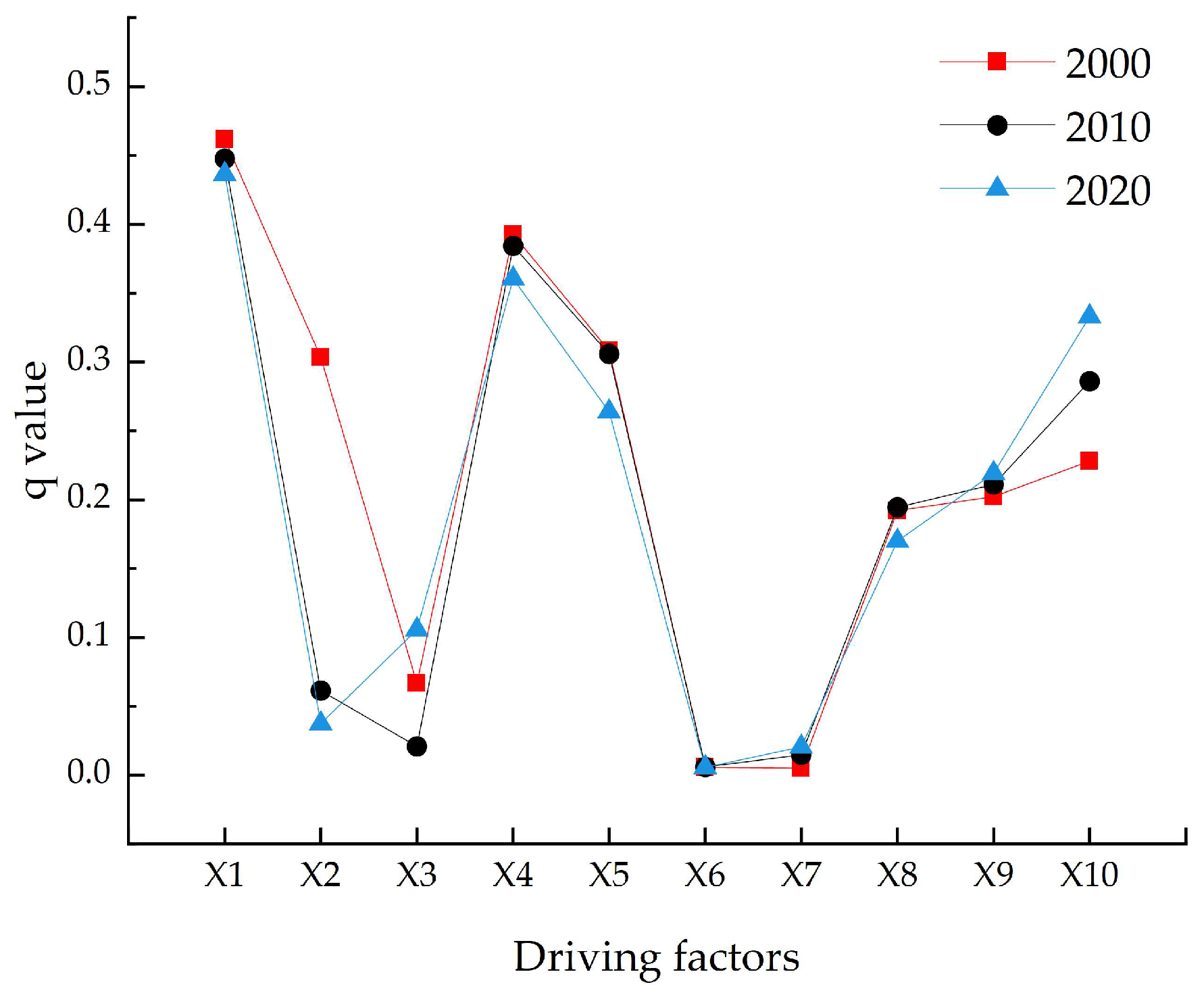
3.4.1. Single Factor Detection Analysis

In 2000, the influence of each factor on RSEI in the three northeastern provinces was ranked as follows: X1 (0.46) > X4 (0.39) > X5 (0.30) > X2 (0.30) > X10 (0.23) > X9 (0.20) > X8 (0.20) > X3 (0.07) > X6 (0. 01) > X7 (0.01). It can be seen that the land-use type factors have a great influence on the spatial distribution of the RSEI in the three northeastern provinces. The explanatory power of the gross output value of farming, forestry, animal husbandry and fishery is 0.23, indicating that agriculture was also an important factor affecting the environment quality (Figure 9). The main influencing factors of the RSEI changes in 2010 were land-use types (0.45), elevation (0.38), slope (0.30), and the gross output value of agriculture, forestry, animal husbandry and fishery (0.29), etc. The land-use types still had the highest explanatory power for RSEI. When compared with 2000, the q value of the total social consumption production, agriculture, forestry, animal husbandry and fishery had increased, indicating that with the development of the economy, the influence of these factors increased in the RSEI changes. The explanatory power of each factor in 2020 were as follows: X1 (0.44) > X4 (0.36) > X10 (0.33) > X5 (0.26) > X9 (0.22) > X8 (0.17) > X3 (0.11) > X2 (0.04) > X7 (0. 02) > X6 (0.01), the land-use types had the largest explanatory power, followed by elevation and the gross output value of agriculture, forestry, animal husbandry and fishery. The influence of GDP decreased compared with 2010, indicating that economic development slowed down during this period, but the influence of the gross output value of agriculture, forestry, animal husbandry and fishery was on the rise. The influence of the land-use types on RSEI was consistently strong in all three periods. The influence of the gross output value of farming, forestry, animal husbandry and fishery and population density has steadily increased, reflecting the rising role of human activities in driving environmental changes. In the future, it is important for northeastern China to realize economic growth while taking into account the virtuous cycle of the ecological environment.

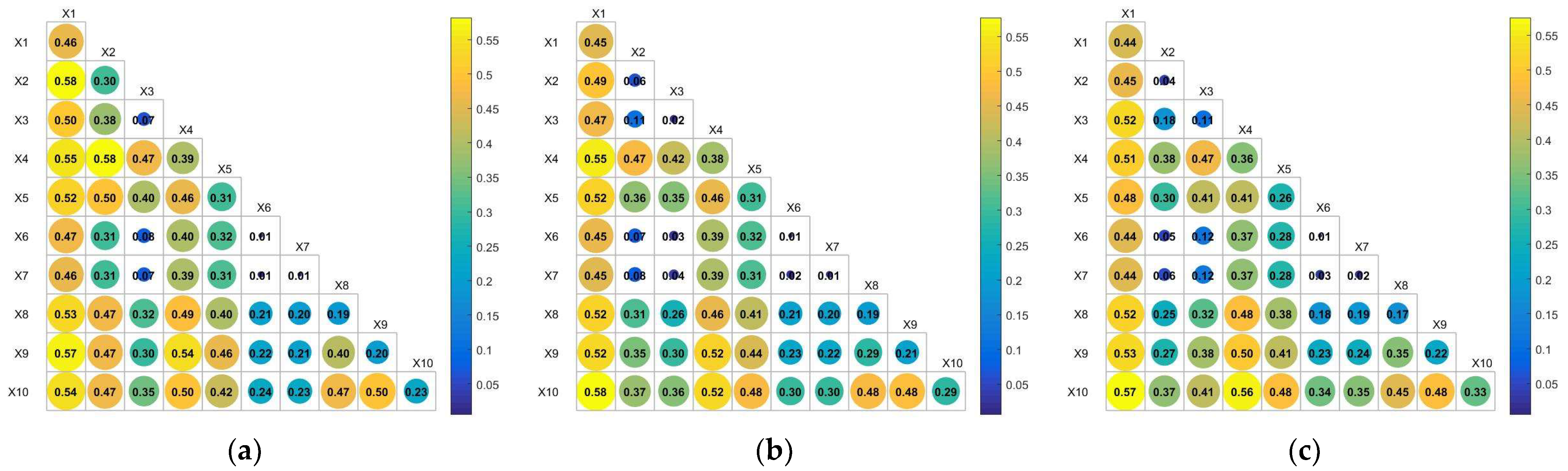
3.4.2. Interaction Detection Analysis

The interactive detection results of environmental quality impact factors in 2000, 2010 and 2020 are shown in Figure 10. The interaction of the influence factors over the three years show the characteristics of double factor enhancement or nonlinear enhancement, indicating that the changes in the environment in the three northeastern provinces were the result of the combined action of multiple factors. The interactions between land-use types and precipitation in 2000 has the strongest explanatory power, with a q value of 0.582, followed by the interactions between rainfall and elevation (0.577). In 2010, the interaction force between land-use types and the gross output value of farming, forestry, animal husbandry and fishery is strongest (0.577), followed by land-use types and elevation (0.553). In 2020, the q value of the land-use types and total output value of agriculture, forestry, animal husbandry and fishery reached 0.575, followed by elevation and the gross output value of farming, forestry, animal husbandry and fishery with a q value of 0.562. The single factor explanatory power of the four social and economic factors, including population density, GDP and the total social consumption production, were less than 0.333, and the maximum interaction force was 0.577 when superimposed with natural factors. The influence of slope and aspect factor, which has the weakest explanatory power of single factor, also increased significantly after being superimposed with other factors.
In conclusion, the analysis of the driving factors based on the geographic detector for the three northeastern provinces concluded that land-use type was the dominant factor affecting environment quality. The interactions between land-use type factors and other factors were all strong, probably because land cover conditions were closely related to ecological quality and influence human activities and vegetation distribution, making other factors influenced to some extent.

4. Discussion

At present, there are few papers on the long-term quantitative assessment of spatial and temporal patters of the ecological environment in northeast China based on the remote sensing ecological index, and this study is a good supplement. In addition, we used more comprehensive data analysis to further explore the intrinsic impact mechanism of the regional environmental changes. The results reveal that the environmental quality in northeastern China improved gradually from 2000 to 2020, and the land-use type is the main driving force. The implementation of the key ecological projects may be an important reason for the improvement of ecological environment.
In the last two decades, China has implemented a series of key ecological construction projects in the northeast region, which have promoted the pace of environment constructions. Including the Project of Returning Farmland to Forest and Grassland [31], the Natural Forest Protection [32] and the Three-North Shelterbelt Forest Program [33]. Since the implementation of these projects, some achievements have been made in ecological constructions. The forest, grassland and wetland resources have been well protected, watershed management has achieved remarkable results, and the resources development and utilization have become increasingly reasonable, all of which have played a positive role in promoting and improving the regional ecological environment.

4.1. The Mechanism of Environmental Changes

Both nature and social economy will have different degrees of influence on regional ecological environments. Previous studies have exhibited the significant influence of natural factors on regional ecological environments [34,35]. The natural conditions affect the quality of the ecosystem by changing the land surface water resources and surface conditions, while the ecosystem also regulated the natural factors through the physiological effects on vegetation, and the interactions between the two [36,37]. For example, climate change can lead to problems such as continuous warming or cooling, damage to crops, etc. [38,39]. At the same time, the surface temperature and stomatal conductance of vegetation leaves also change with the climate, promoting warming in cold regions by reducing surface albedo and causing evaporation-driven cooling in arid areas [36]. It has been found that the land-use types play a dominant role in driving environmental changes in the three northeastern provinces. Yang et al. [40] also obtained similar conclusions by studying the spatial and temporal distribution characteristics of the intensity of territorial development and the response of habitat quality in the northeast region, and their results show that there was a significant spatial correlation between the two, with an obvious local spatial agglomeration pattern.
In addition, the previous studies revealed that different land cover types have different water conservation characteristics, which determine the differences in plant species, growth characteristics and spacing [41]. For example, in a given external environment, the same crop variety on different types of land will produce differences because of changes in soil properties, which will have different degrees of impact on the regional environment over time [42]. Therefore, to further explore the impact of land-use type on the ecological environment quality, Figure 11 shows the distribution of land cover types in the three northeastern provinces in 2000, 2010 and 2020, and we calculated the net changes in area for each type, as shown in Figure 12. According to the statistics, the changes in land-use patterns during 2010–2020 were higher than during 2000–2010, indicating faster development. Cropland and grassland incurred a net loss of 2.60 × 10⁴ km2 and 2.72 × 10⁴ km2 from 2000 to 2020, respectively, the remaining land types showed varying degrees of net growth, with the most pronounced increase in artificial surfaces at 3.34 × 10⁴ km2. It is worth noting that cropland and forest occupy a large proportion, and that the sum of the two reached 82.81%, 82.61% and 82.36% in 2000, 2010 and 2020, respectively.
When combined with Figure 6, it can be seen that the ecological environment of forest and eastern cropland were above the medium level, mainly because they have the advantages of conserving water source, conserving soil and water, and reducing the variation range of runoff. In addition, the rich vegetation structures can absorb harmful substances from the air through photosynthesis and thereby regulate the climate. Having a higher proportion of cultivated land and forest may have a positive effect on the ecological environment. Similarly, the loss of forest and cultivated land may also be an important reason for the decline of environmental quality. We selected two areas with obvious environmental quality decline in C and D in Figure 3, and Table 5 shows the changes in the transfer of land-use type. The common feature of the two areas is that the urbanization process occupies a large amount of cultivated land, which was 677.5 km2 and 642.5 km2, respectively. It can be seen that the urbanization in central Jilin and central Liaoning occupies a large amount of cultivated land, which is an important reason for the decline of environmental quality. In addition, we note that western Jilin and western Liaoning are covered by cropland and grasslands. Those areas are known for wind, sand and drought, belonging to typical arid and semi-arid areas, temperate continental climate with strong evaporation, wind and sand promote the fragile ecological environment of the region and, coupled with unreasonable land use and overgrazing, may be an important reason for the poor quality in those areas. The results show that taking into account the virtuous cycle of an ecological environment while promoting urban and rural construction and rational use of land is an important challenge that northeast China may face in the future.
The social economy has driven changes in the ecological environment, among which the comprehensive and guiding role of macro policy has been particularly important [43]. Before the 20th century, companies in the northeast grew slowly and their relative importance in China significantly decreased. In addition to the problems of the economic system, the extensive development and production mode has long restricted the development of the northeast region at the expense of natural resources and environmental pollution [44]. To promote coordinated regional development, the central government of China issued Several Opinions on Implementing the Revitalization Strategy of Northeast China and other Old Industrial Bases in 2003. During the decade when many of those policies were implemented, the economy of the northeast made extraordinary progress. Since 2013, the economy of northeast China has begun to decline, and the developmental power was obviously insufficient. To this end, China has launched a new round of revitalization of the northeast, with a special emphasis on fostering endogenous growth drivers and enhancing development vitality. It has been found that the influence of the social economy on regional ecological environment gradually increased during 2000–2020. The role of agriculture, forestry, animal husbandry and fishery increased significantly, and a series of “strengthening agriculture and benefiting agriculture” policies formulated by China may be an important driver of this phenomenon. For example, in 2010, the Ministry of Agriculture of The State Council of China issued the Guidance on Accelerating the Transformation of Agricultural Development Mode in Northeast Region and Building Modern Agriculture, aiming to further give play to resource advantages and to accelerate the transformation of agricultural development in northeastern regions. In 2017, to strengthen policy supports for the development of animal husbandry in the northeast, the State Council of China issued the Guiding Opinions on Accelerating the Development of Modern Animal Husbandry in Major Grain-Producing Areas of Northeast China. In 2020, the notice of the Action Plan for Conservation Tillage of Black Land in Northeast China was issued to effectively reduce soil wind erosion and soil erosion, improve soil fertility, maintain soil moisture and drought resistance, and improve agricultural, ecological and economic benefits. In conclusion, the policies of “strengthening agriculture and benefiting agriculture” have been an important reason for the increasing influence of socio-economic factors on ecological quality in northeastern China.

4.2. Uncertainties

Although we selected the ten major natural and socioeconomic factors to analyze the driving mechanisms of environmental changes in northeastern China, the variety of causes of environmental changes makes it inevitable that there was a certain degree of uncertainty in the driving mechanisms, and that selecting more representative drivers to quantitatively analyze the causes of environmental changes in northeastern China is one of the tasks we will undertake in the future. Since this paper focuses only on terrestrial environmental quality, we removed water body information. It is also an important task to add more reasonable environmental variables to improve the model and comprehensively consider the environmental changes on the Earth’s surface. There were different sources of uncertainty in satellite remote sensing products, including the input surface reflectance, inversion algorithm, model processing and so on [45]. There was a certain degree of error between the simulation scale and the actual situation. The image with finer resolution can make up the gap between the products and the actual situation. The comparison and integration of multiple products can also help to improve the accuracy of the use of those products.

5. Conclusions

Based on the GEE platform, this study constructed a remote sensing ecological index (RSEI) in northeastern China from 2000 to 2020, and collected economic data based on the actual situations. The spatiotemporal change patterns and driving forces of the ecological environment were comprehensively analyzed.
Over the past 20 years, the environmental quality of China’s northeast has improved. Trend analyses show that the growth rate of RSEI is 0.006/a, and an increase of 12.45% compared to 2000. Among these, the highest improvement rate of environmental quality occurred in the southwestern and northeastern parts of Heilongjiang province, whereas the central Jilin province and central Liaoning province experienced a predominant degradation of environmental quality induced by the extensive land cover conversion from vegetation into artificial surfaces. It is suggested that coordinated measures of improvement of regional environmental management and the development of the circular economy could be effective ways to solve these environmental problems. The single-factor detection results show that land-use type was the dominant factor affecting environmental changes in northeastern China, and that the sum of cropland and forest in 2000, 2010 and 2020 was as high as 82.81%, 82.61% and 82.36%, respectively. Under the premise of ensuring biodiversity and ecological balance, expanding cropland and forest area is the key to improving environmental quality and greening the earth. In the face of the decline of the driving effect of natural factors on environmental quality and the increased role of socio-economic factors, it is important for sustainable development to promote the economy while taking into account the virtuous cycle of the ecological environment.

Author Contributions

Conceptualization, E.G., F.S. and Z.W.; methodology, E.G. and J.Z.; software, J.Z. and H.H.; formal analysis, F.S. and J.Z.; investigation, Z.W.; resources, Z.W. and Q.H.; data curation, E.G. and F.S.; writing—original draft preparation, E.G.; writing—review and editing, Z.W.; visualization, J.Z. and H.H.; supervision, Z.W. and Q.H.; project administration, F.S. and Z.W. All authors have read and agreed to the published version of the manuscript.

Funding

This research was funded by the Key Science and Technology Project of the Ministry of Water Resources (SKR-2022017), the Joint Funds of the National Natural Science Foundation of China (U2243212, U21A20109), and Special Research Fund of the YRIHR (HKY-JBYW-2022-13).

Institutional Review Board Statement

Not applicable.

Informed Consent Statement

Not applicable.

Data Availability Statement

The data are available on request from the corresponding author. The relevant code in this paper can be referred to the link (https://code.earthengine.google.com/5a4658d5fa30c829537e745cc3e04388 (accessed on 2 June 2022)).

Acknowledgments

We gratefully thank the anonymous reviewers for their useful comments and constructive suggestions on the manuscript.

Conflicts of Interest

The authors declare no conflict of interest.

References

  1. Yao, X.; Chen, W.; Song, C.; Gao, S. Sustainability and efficiency of water-land-energy-food nexus based on emergy-ecological footprint and data envelopment analysis: Case of an important agriculture and ecological region in Northeast China. J. Clean. Prod. 2022, 379, 134854. [Google Scholar] [CrossRef]
  2. Crichton, K.A.; Anderson, K.; Charman, D.J.; Gallego-Sala, A. Seasonal climate drivers of peak NDVI in a series of Arctic peatlands. Sci. Total Environ. 2022, 838, 156419. [Google Scholar] [CrossRef] [PubMed]
  3. Vernet, M.; Ellingsen, I.; Marchese, C.; Bélanger, S.; Cape, M.; Slagstad, D.; Matrai, P.A. Spatial variability in rates of net primary production (NPP) and onset of the spring bloom in Greenland shelf waters. Prog. Oceanogr. 2021, 198, 102655. [Google Scholar] [CrossRef]
  4. Piao, S.; Wang, X.; Park, T.; Chen, C.; Lian, X.; He, Y.; Bjerke, J.W.; Chen, A.; Ciais, P.; Tømmervik, H.; et al. Characteristics, drivers and feedbacks of global greening. Nat. Rev. Earth Environ. 2020, 1, 14–27. [Google Scholar]
  5. Wu, J.; Wang, X.; Zhong, B.; Yang, A.; Jue, K.; Wu, J.; Zhang, L.; Xu, W.; Wu, S.; Zhang, N.; et al. Ecological environment assessment for Greater Mekong Subregion based on Pressure-State-Response framework by remote sensing. Ecol. Indic. 2020, 117, 106521. [Google Scholar] [CrossRef]
  6. Wu, C.; Liu, G.; Huang, C.; Liu, Q.; Guan, X. Ecological Vulnerability Assessment Based on Fuzzy Analytical Method and Analytic Hierarchy Process in Yellow River Delta. Int. J. Environ. Res. Public Health 2018, 15, 855. [Google Scholar] [CrossRef] [Green Version]
  7. Sun, L.; Yu, Y.; Gao, Y.; He, J.; Yu, X.; Malik, I.; Wistuba, M.; Yu, R. Remote Sensing Monitoring and Evaluation of the Temporal and Spatial Changes in the Eco-Environment of a Typical Arid Land of the Tarim Basin in Western China. Land 2021, 10, 868. [Google Scholar] [CrossRef]
  8. Xu, H. A remote sensing urban ecological index and its application. Shengtai Xuebao Acta Ecol. Sin. 2013, 33, 7853–7862. [Google Scholar]
  9. Nie, X.; Hu, Z.; Zhu, Q.; Ruan, M. Research on Temporal and Spatial Resolution and the Driving Forces of Ecological Environment Quality in Coal Mining Areas Considering Topographic Correction. Remote Sens. 2021, 13, 2815. [Google Scholar] [CrossRef]
  10. Xiong, Y.; Xu, W.; Lu, N.; Huang, S.; Wu, C.; Wang, L.; Dai, F.; Kou, W. Assessment of spatial–temporal changes of ecological environment quality based on RSEI and GEE: A case study in Erhai Lake Basin, Yunnan province, China. Ecol. Indic. 2021, 125, 107518. [Google Scholar] [CrossRef]
  11. Zhang, J.; Zhou, Q.; Cao, M.; Liu, H. Spatiotemporal Change of Eco-Environmental Quality in the Oasis City and Its Correlation with Urbanization Based on RSEI: A Case Study of Urumqi, China. Sustainability 2022, 14, 9227. [Google Scholar] [CrossRef]
  12. Firozjaei, M.K.; Kiavarz, M.; Homaee, M.; Arsanjani, J.J.; Alavipanah, S.K. A novel method to quantify urban surface ecological poorness zone: A case study of several European cities. Sci. Total Environ. 2021, 757, 143755. [Google Scholar] [CrossRef] [PubMed]
  13. Wang, B.; Tian, J.; Wang, S. Process and mechanism of transition in regional land use function guided by policy: A case study from Northeast China. Ecol. Indic. 2022, 144, 109527. [Google Scholar] [CrossRef]
  14. Yu, L.; Liu, T.; Bu, K.; Yan, F.; Yang, J.; Chang, L.; Zhang, S. Monitoring the long term vegetation phenology change in Northeast China from 1982 to 2015. Sci. Rep. 2017, 7, 14770. [Google Scholar] [CrossRef] [Green Version]
  15. Wang, H.; Yang, S.; Wang, Y.; Gu, Z.; Xiong, S.; Huang, X.; Sun, M.; Zhang, S.; Guo, L.; Cui, J.; et al. Rates and causes of black soil erosion in Northeast China. Catena 2022, 214, 106250. [Google Scholar] [CrossRef]
  16. Gorelick, N.; Hancher, M.; Dixon, M.; Ilyushchenko, S.; Thau, D.; Moore, R. Google Earth Engine: Planetary-scale geospatial analysis for everyone. Remote Sens. Environ. 2017, 202, 18–27. [Google Scholar] [CrossRef]
  17. Wu, H.; Fang, S.; Yang, Y.; Cheng, J. Changes in habitat quality of nature reserves in depopulating areas due to anthropogenic pressure: Evidence from Northeast China, 2000–2018. Ecol. Indic. 2022, 138, 108844. [Google Scholar] [CrossRef]
  18. Xu, H. Modification of normalised difference water index (NDWI) to enhance open water features in remotely sensed imagery. Int. J. Remote Sens. 2006, 27, 3025–3033. [Google Scholar] [CrossRef]
  19. Huang, S.; Tang, L.; Hupy, J.P.; Wang, Y.; Shao, G. A commentary review on the use of normalized difference vegetation index (NDVI) in the era of popular remote sensing. J. For. Res. 2021, 32, 2719. [Google Scholar] [CrossRef]
  20. Xu, N.; Deng, F.; Liu, B.; Li, C.; Fu, H.; Yang, H.; Zhang, J. Changes in the Urban Surface Thermal Environment of a Chinese Coastal City Revealed by Downscaling MODIS LST with Random Forest Algorithm. J. Meteorol. Res. 2021, 35, 759–774. [Google Scholar] [CrossRef]
  21. Hu, X.; Xu, H. A new remote sensing index for assessing the spatial heterogeneity in urban ecological quality: A case from Fuzhou City, China. Ecol. Indic. 2018, 89, 11–21. [Google Scholar] [CrossRef]
  22. Xu, H. A new index for delineating built-up land features in satellite imagery. Int. J. Remote Sens. 2008, 29, 4269–4276. [Google Scholar] [CrossRef]
  23. Jin, S.; Sader, S.A. Comparison of time series tasseled cap wetness and the normalized difference moisture index in detecting forest disturbances. Remote Sens. Environ. 2005, 94, 364–372. [Google Scholar] [CrossRef]
  24. Tang, H.; Fang, J.; Xie, R.; Ji, X.; Li, D.; Yuan, J. Impact of Land Cover Change on a Typical Mining Region and Its Ecological Environment Quality Evaluation Using Remote Sensing Based Ecological Index (RSEI). Sustainability 2022, 14, 12694. [Google Scholar] [CrossRef]
  25. Hu, Q.; Gong, E.; Wang, Z.; Zhang, J.; Liu, W.; Feng, F. Spatiotemporal Changes in Leaf Area and Carbon Sequestration of Terrestrial Vegetation in China over the Last Two Decades. Forests 2022, 13, 1623. [Google Scholar] [CrossRef]
  26. Hu, Z.; Liu, S.; Zhong, G.; Lin, H.; Zhou, Z. Modified Mann-Kendall trend test for hydrological time series under the scaling hypothesis and its application. Hydrol. Sci. J. 2020, 65, 2419–2438. [Google Scholar] [CrossRef]
  27. Wang, J.; Xu, C. Geodetector: Principle and prospective. Acta Geogr. Sin. 2017, 72, 116–134. [Google Scholar]
  28. Liu, C.; Li, W.; Zhu, G.; Zhou, H.; Yan, H.; Xue, P. Land Use/Land Cover Changes and Their Driving Factors in the Northeastern Tibetan Plateau Based on Geographical Detectors and Google Earth Engine: A Case Study in Gannan Prefecture. Remote Sens. 2020, 12, 3139. [Google Scholar] [CrossRef]
  29. Dong, Y.; Yin, D.; Li, X.; Huang, J.; Su, W.; Li, X.; Wang, H. Spatial–Temporal Evolution of Vegetation NDVI in Association with Climatic, Environmental and Anthropogenic Factors in the Loess Plateau, China during 2000–2015: Quantitative Analysis Based on Geographical Detector Model. Remote Sens. 2021, 13, 4380. [Google Scholar] [CrossRef]
  30. Piao, S.; Mohammat, A.; Fang, J.; Cai, Q.; Feng, J. NDVI-based increase in growth of temperate grasslands and its responses to climate changes in China. Glob. Environ. Chang. 2006, 16, 340–348. [Google Scholar] [CrossRef]
  31. Liu, J.; Li, S.; Ouyang, Z.; Tam, C.; Chen, X. Ecological and socioeconomic effects of China’s policies for ecosystem services. Proc. Natl. Acad. Sci. USA 2008, 105, 9477–9482. [Google Scholar] [CrossRef] [PubMed] [Green Version]
  32. Li, C.; Zhang, Y.; Shen, Y.; Kong, D.; Zhou, X. LUCC-Driven Changes in Gross Primary Production and Actual Evapotranspiration in Northern China. J. Geophys. Res. Atmos. 2020, 125, e2019JD031705. [Google Scholar] [CrossRef]
  33. Li, M.-M.; Liu, A.-T.; Zou, C.-J.; Xu, W.-D.; Shimizu, H.; Wang, K.-Y. An overview of the “Three-North” Shelterbelt project in China. For. Stud. China 2012, 14, 70–79. [Google Scholar] [CrossRef]
  34. Yuan, B.; Fu, L.; Zou, Y.; Zhang, S.; Chen, X.; Li, F.; Deng, Z.; Xie, Y. Spatiotemporal change detection of ecological quality and the associated affecting factors in Dongting Lake Basin, based on RSEI. J. Clean. Prod. 2021, 302, 126995. [Google Scholar] [CrossRef]
  35. Zhang, M.; Kafy, A.A.; Ren, B.; Zhang, Y.; Tan, S.; Li, J. Application of the Optimal Parameter Geographic Detector Model in the Identification of Influencing Factors of Ecological Quality in Guangzhou, China. Land 2022, 11, 1303. [Google Scholar] [CrossRef]
  36. Forzieri, G.; Alkama, R.; Miralles, D.G.; Cescatti, A. Satellites reveal contrasting responses of regional climate to the widespread greening of Earth. Science 2017, 356, 1180–1184. [Google Scholar] [CrossRef] [Green Version]
  37. Deng, L.; Shangguan, Z. Afforestation Drives Soil Carbon and Nitrogen Changes in China. Land Degrad. Dev. 2017, 28, 151–165. [Google Scholar] [CrossRef] [Green Version]
  38. Marchin, R.M.; Backes, D.; Ossola, A.; Leishman, M.R.; Tjoelker, M.G.; Ellsworth, D.S. Extreme heat increases stomatal conductance and drought-induced mortality risk in vulnerable plant species. Glob. Chang. Biol. 2022, 28, 1133–1146. [Google Scholar] [CrossRef]
  39. Lawrence, P.J.; Chase, T.N. Investigating the climate impacts of global land cover change in the community climate system model. Int. J. Climatol. 2010, 30, 2066–2087. [Google Scholar] [CrossRef]
  40. Yang, Z.; Wang, S.; Guo, M.; Tian, J.; Zhang, Y. Spatiotemporal Differentiation of Territorial Space Development Intensity and Its Habitat Quality Response in Northeast China. Land 2021, 10, 573. [Google Scholar] [CrossRef]
  41. Du, X.; Jian, J.; Du, C.; Stewart, R.D. Conservation management decreases surface runoff and soil erosion. Int. Soil Water Conserv. Res. 2022, 10, 188–196. [Google Scholar] [CrossRef]
  42. Maikhuri, R.K.; Semwal, R.L.; Rao, K.S.; Singh, K.; Saxena, K.G. Growth and ecological impacts of traditional agroforestry tree species in Central Himalaya, India. Agrofor. Syst. 2000, 48, 257–271. [Google Scholar] [CrossRef]
  43. Yang, Q.; Zhang, L.; Zhang, J.; Zou, S. System simulation and policy optimization of China’s coal production capacity deviation in terms of the economy, environment, and energy security. Resour. Policy 2021, 74, 102314. [Google Scholar] [CrossRef]
  44. Zhu, A. Investigation on the Status Quo of Ecological Environment Construction in Northeast China from the Perspective of Dual Carbon Goals. J. Environ. Public Health 2022, 2022, 8360888. [Google Scholar] [CrossRef]
  45. Fang, H.; Wei, S.; Jiang, C.; Scipal, K. Theoretical uncertainty analysis of global MODIS, CYCLOPES, and GLOBCARBON LAI products using a triple collocation method. Remote Sens. Environ. 2012, 124, 610–621. [Google Scholar] [CrossRef]
Figure 1. Geographical location map of the study area.
Sustainability 14 16304 g001
Figure 2. Research flowchart.
Sustainability 14 16304 g002
Figure 3. Spatial changes map in the mean RSEI.
Sustainability 14 16304 g003
Figure 4. Annual trends in (a) RSEI, (b) NDBSI, (c) LST, (d) NDVI and (e) WET, with 95% confidence intervals in orange.
Sustainability 14 16304 g004
Figure 5. Area changes in the environmental quality grade in 2000, 2010 and 2020.
Sustainability 14 16304 g005
Figure 6. Grade distribution map of environmental quality in 2000, 2010 and 2020.
Sustainability 14 16304 g006
Figure 7. Transfer chart of environmental quality levels from 2000 to 2010 (a), and 2010 to 2020 (b).
Sustainability 14 16304 g007
Figure 8. Spatial changes of the environmental quality grades from 2000 to 2010 and from 2010 to 2020.
Sustainability 14 16304 g008
Figure 9. Detection results of impact factors from 2000 to 2020.
Sustainability 14 16304 g009
Figure 10. Interaction detection in (a) 2000, (b)2010 and (c) 2020 of impact factors.
Sustainability 14 16304 g010
Figure 11. Land-use type distribution map of the three northeastern provinces in 2000, 2010 and 2020.
Sustainability 14 16304 g011
Figure 12. The net changes in land-use type area from 2000 to 2010, 2010 to 2020 and 2000 to 2000.
Sustainability 14 16304 g012
Table 1. Indicators and date descriptions.
IndexProduct NameResolutionSource
Land-use typesGlobeland3030 mhttps://globeland30.org (accessed on 8 January 2022)
PrecipitationNCEP1000 mhttps://www.nco.ncep.noaa.gov (accessed on 11 June 2022)
TemperatureGLDAS1000 mhttps://ldas.gsfc.nasa.gov (accessed on 11 June 2022)
Population densityGPWv4.111000 mhttps://sedac.ciesin.columbia.edu (accessed on 11 June 2022)
SocioeconomicGDP; total social consumption production; gross output value of farming, forestry, animal husbandry and fishery https://tjj.jl.gov.cn (accessed on 13 July 2022)
https://tjj.hlj.gov.cn (accessed on 13 July 2022)
https://tjj.ln.gov.cn (accessed on 13 July 2022)
Table 2. Calculation methods of indicators.
IndicatorsCalculation MethodsExplanation
NDVI [19] NDVI = ρ nir ρ red ρ nir + ρ red ρ i represents the reflectance of NIR and red bands, respectively
LST [20] LST = 0.02 × D N 273.15 DN represents the gray value of land surface temperature
NDBSI [21,22] NDBSI = IBI + SI 2   SI = ( ρ swir 1 + ρ red ) ( ρ nir + ρ blue ) ( ρ swir 1 + ρ red ) + ( ρ nir + ρ blue )   IBI = 2   ρ swir 1 ρ swir 1 + ρ nir [ ρ nir ρ nir + ρ red + ρ green ρ green + ρ swir 1 ] 2   ρ swir 1 ρ swir 1 + ρ nir + [ ρ nir ρ nir + ρ red + ρ green ρ green + ρ swir 1 ] ρ swir 1 ,   ρ red ,   ρ nir ,   ρ blue , and ρ green correspond to the reflectance of SWIR1, red, NIR, blue, and green bands, respectively
WET [23] T C W = 0.1147 ρ red + 0.2489 ρ nir 1 + 0.2408 ρ blue + 0.3132 ρ green   0.3122 ρ nir 2 0.6416 ρ swir 1 0.5087 ρ swir 2 ρ red ,   ρ nir 1 ,   ρ blue ,   ρ green ,   ρ nir 2 ,   ρ swir 1 , and ρ swir 2 correspond to the reflectance of the reflectance of the red, NIR1, blue, green, NIR2, short-wavelength infrared 1 (SWIR1), and SWIR2 bands, respectively
Table 3. Influencing factors of environmental quality.
Factor
Types
Driving FactorsFactor
Symbols
UnitType
Numbers
Natural
factors
Land-use typesX1-6
PrecipitationX2mm7
TemperatureX3°C7
ElevationX4m7
SlopeX5°7
AspectX6°9
Socioeconomic
factors
Population densityX7People\km²9
GDPX8Billion9
Total social consumption and retail salesX9Billion9
Gross output value of farming, forestry, animal husbandry and fisheryX10Billion9
Table 4. Principal component analysis results.
YearIndicatorsPC1PC2PC3PC4
2000NDVI0.51740.7085−0.0629−0.4756
LST−0.56610.2668−0.7711−0.1164
NDBSI−0.55080.0010.505−0.6644
WET0.3291−0.6532−0.3823−0.5645
Eigenvalue0.05460.00540.00390.001
Percent Eigenvalue/%84.008.346.041.63
2010NDVI0.53090.6949−0.26550.4058
LST−0.59450.1243−0.7930.046
NDBSI−0.4355−0.00260.37370.8188
WET0.4181−0.7082−0.40110.4032
Eigenvalue0.040.00620.00270.0005
Percent Eigenvalue/%80.8312.595.451.13
2020NDVI0.5072−0.7054−0.49370.0368
LST−0.7234−0.0374−0.68920.0062
NDBSI−0.02930.00330.03960.9987
WET0.46730.7078−0.52870.0323
Eigenvalue0.02610.00710.00340
Percent Eigenvalue/%71.3219.49.270.01
Table 5. Land cover transfer matrix for zones C and D (km2).
2000–2020CD
CroplandForestGrasslandArtificial SurfaceOthersCroplandForestGrasslandArtificial SurfaceOthers
Cropland2494.255915677.5203960253.5142.5642.596.75
Forest58.511012.2518.754.5241.5837111.25237.25
Grassland14.757.253.257.50.5136.5100.2594.5445.25
Artificial surface193.7512.51.75337.52388.7524.2527.5841.529
Others7.2540452.255594.751460.75
Publisher’s Note: MDPI stays neutral with regard to jurisdictional claims in published maps and institutional affiliations.

