Article

Autonomous Mobility: A Potential Opportunity to Reclaim Public Spaces for People

by
Maryam Fayyaz
,
Esther González-González
* and
Soledad Nogués
GEURBAN Research Group, School of Civil Engineering, University of Cantabria, 39005 Santander, Spain
*
Author to whom correspondence should be addressed.
Sustainability 2022, 14(3), 1568; https://doi.org/10.3390/su14031568
Submission received: 31 December 2021 / Revised: 24 January 2022 / Accepted: 26 January 2022 / Published: 28 January 2022

Abstract

:
The advent of autonomous vehicles (AVs) has the potential to drastically change society and the way we understand, plan and design cities and regions, just as automobiles did a century ago. In the current context of climate change, sustainable urban environments based on active mobility (walking and cycling), urban proximity and green spaces, are increasingly in demand, leading to the emergence of new interventions and urban models. Although these trends may be affected by the arrival of AVs, most decision-makers and planners still do not address these issues in their current planning. This is because of the confusion associated with the diversity of impacts of AVs, but also by the lack of design recommendations and planning tools. To shed light on these aspects, this paper reviews the relationship between mobility and urban public space, the impacts of AVs on urban space and design proposals and strategies aimed at configuring driverless cities, with special focus on street design. The results of the review show that the implementation of AVs can be a great opportunity to liberate urban space and reclaim it for people, in line with new urban models such as the superblocks (Barcelona), the 15-minute city (Paris), or tactical urbanism interventions against COVID-19. However, it may also entail risks such as a reduction in active mobility or public transport use. The magnitude and direction of these impacts will depend on crucial decisions that need to be taken now, such as encouraging shared used over ownership, and establishing citizen-centred urban planning and design objectives and strategies to make AV deployment the most beneficial for all.

1. Introduction

The arrival of automobiles a century ago brought about one of the greatest changes in regional and urban structures and planning in history. Accessibility increased considerably, allowing longer distances to be travelled in the same daily commuting time [1,2], thus radically changing the process of urban development and the relationship between settlements. The arrival of autonomous vehicles (AVs), also known as driverless cars [3], also implies positive benefits, such as being safer, more sustainable and comfortable [4,5,6] than cars. This, coupled with the economic interests of large companies and governments to be the first to develop and deploy them, respectively [7], could lead to their mass use and new radical changes in our cities
AVs, considered one of the three new transportation revolutions along with shared and electric vehicles [3], are expected to be implemented, first in roads and then in streets, between 2030 and 2050 [8,9]. Their rapid development and likely massive use will bring a series of significant impacts and changes in mobility and urban dynamics. According to the studies so far on this subject, both positive (i.e., reduction of circulating vehicles and congestion, elimination of parking… [5,10]), and negative (i.e., increase in vehicle-miles travelled, enhancement of urban sprawl [11,12,13], reduction of walking and cycling [5,14]) impacts can be generated. To date, only a few cities, mainly in the American context, have started to consider AVs in their transportation plans [15,16], but no steps are being taken to prepare cities from a land used planning perspective [12]. The limited research from the urban planning perspective, the disparity of potential impacts and the lack of policy and design strategies make it difficult for city planners and decision-makers to introduce measures necessary to ensure that the arrival of AVs is in line with the most sustainable and people-centred objectives of current urbanism. The crucial matter is to plan cities in advance so that AVs adapt to and help meet their objectives rather than cities having to adapt to the effects that AVs may generate [7,11,17,18,19].
While there is great uncertainty about the sign and true magnitude of the impacts, there is also a unique opportunity to redesign public space, especially concerning streets [19,20,21]. Precisely because of their autonomous capacity, such vehicles make it possible to rethink the design of streets in a dynamic, open and flexible way, allowing their multi-purpose use and their reclamation as essential public spaces which put people as priority.
This article aims to help and encourage urban decision-makers to start planning and designing for the driverless city in order to meet sustainable goals, and achieve citizen-centred, attractive, high-quality and liveable cities. To do so, it addresses three key questions through a review of the scientific literature: (1) How will the proliferation of AVs change the mobility system and influence urban space? (2) How will AVs affect public space? (3) How can urban space reclamation for people be achieved by designing public spaces, and especially streets? These questions are related first, to the historical evolution of mobility and public space relationships, especially since the advent of the automobile, and new planning trends; second, to studies on the expected impacts of AVs in the urban space; and third, to emerging design proposals for the driverless city.
The rest of this article is structured as follows. Section 2 describes the main components of urban public space, its relationship with mobility and its historical evolution. Section 3 delves deeper into the studies that estimate the impacts of AVs on urban space, focusing on the amount of vehicular space that can be released. Section 4 deals with incipient design proposals for the driverless city, with an especial focus on street design. Finally, Section 5 draws the main conclusions and further lines of research.

2. Methodology

This study is based on a narrative literature review aimed at answering the three aforementioned questions raised in the study. A keyword search was carried out during November and December 2021, in the main search engines (Web of Science, Scopus and Google Scholar), supplemented by snowball techniques. The studies reviewed in this paper are mainly academic papers, although reports from practitioners, government agencies and consultants were also considered. The revision was carried out in three steps, as follows:
  • First question: How will the proliferation of AVs change the mobility system and influence urban space?
The answer to this question was first addressed by reviewing academic documents and studies on the definition of the concept of urban public space, its components and its historical evolution in relation to mobility, especially since the advent of the automobile (11 studies). The experience of what happened with the arrival of private cars a century ago can help planners understand the different effects in various geographical settings [22] and provide some insights into what can happen if, as on that occasion, a laissez-faire attitude is adopted instead of planning beforehand.
Secondly, a review of academic studies on current trends in urban planning and new models laying the ground for the objectives of future cities (11 studies) was conducted, in order to subsequently check whether the arrival of these new AVs is aligned with them or whether they pose a challenge to their achievement.
  • Second question: How will AVs affect public space?
Once the public space was defined, this question was approached by reviewing studies on the impacts of autonomous vehicles on urban public space. The 20 studies on this topic were identified using keywords considering “Autonomous vehicles” or “automated vehicles” or “self-driving vehicles” and “impacts” or “effects” in combination with “urban space” or “urban form” or “land use”.
  • Third question: How can urban space reclamation for people be achieved by designing public spaces, and especially streets?
After identifying that the main opportunities AVs can provide for urban space design involved streets, this last question was addressed by reviewing studies that provide street design proposals for driverless cities, both from academics (4 studies), practitioners (4 studies) and urban design guidelines (2). The studies on this topic were identified using keywords including “Autonomous vehicles” or “automated vehicles” or self-driving vehicles” and “urban design” or “effects” in combination with “urban design” or “street or “street design”.

3. Literature Review

3.1. Urban Public Space and Mobility

The urban public space is gaining a new momentum in the planning debate. Essential to urban life, public space plays an important role in creating more inclusive, diverse, sociable, liveable and sustainable cities, as well as psychologically healthy communities [23,24]. The definition and typologies of urban public space vary according to the period of history, cultural perceptions, field of knowledge and geographical scale considered. In general, public spaces are formal or informal physical places to talk, rest, play, shop or, host celebrations and public gatherings [25,26]. They are places where people in a community interact with each other, regardless of age, gender, nationality and race, social or economic status [24,27].
Generally, public space is considered to be composed of two basic elements which have competed over time for an increasingly reduced space [23]: the square, which is the exponent of the static dimension, with resting, recreational and citizen social interaction purposes; and the street, that represents the dynamic component, giving access to buildings and where movements take place [28]. Other definitions refer to multiple criteria including nature, morphology and use [27], ownership, control and access [24], geographical scale [29], type of surface, intended users, time-limit access and visual characteristics [30]. Taking all these criteria into account, the list of elements that can be defined as public space expands significantly, parks or green spaces standing out as the third major element of public space.
In ancient cities, the square (Greek Agora, Roman Forum) was the defining element of the city, and it was probably the first time that the use of a public space was given a meaning, while streets were configured as an infill connecting dwellings and spaces for interaction [28]. Cities maintained this human scale until the advent of the industrial revolution when new modes of transport were developed and mobility began to take on a greater prominence in urban design [2]. Wider streets were built and main streets, along which trams and horse carriages run, were constructed. It was also then that space became segregated, distinguishing between pedestrian and vehicular space [31].
Between the 1920s and 1950s, a period known as the automobile era [2,32], one of the biggest changes in urban form and structure in the history of cities took place, differing between the United States and Europe. While North Americans adopted automobiles immediately for all trips, encouraged by the dismantling of trams by car companies and the beginning of zoning policies that encouraged sprawl [32], the old continent, thanks to the compactness of its cities and with a population density twice that of North America [22], continued to rely on shorter daily trips, walking and public transport.
After World War Two, the automobile became the king of the city. Planning was devoted to achieve ever more efficient routes in terms of speed. Traffic engineers became responsible for the design of the space between buildings over design professionals [31]. Urban motorways/highways and more traffic lanes appeared [33], along with the need and demand for parking. Conversely, sidewalks were reduced to a minimum. Streets were turned into traffic arteries supported by well-known architects such as Le Corbusier, car cities being considered successful cities [34].
During the last decades, and especially at present, we are witnessing a call for the reconquest of cities as a response to what Gehl and Gemzøe [25] call “the car-invaded” and even “abandoned city”, where there is no social interaction on public environments. This reconquest pursues a return to the traditional citizen-dominated city, centred on reclaiming public spaces and streets, which is more sustainable and appropriate in the face of current challenges such as climate change. These new principles in urban planning have been greatly boosted in the last year due to the situation of global lock-down and the need for social distance generated by the COVID-19 pandemic [35], although it has also called into question other planning principles such as the promotion of high densities and of public transport [36].
One of these new urban models are the superblocks launched in Barcelona (Spain), whose aim is to group adjacent blocks into a superblock (400 m × 400 m) defined by perimeter streets where vehicles circulate, and whose internal space is freed for other uses, such as green areas and small squares and playgrounds [37]. Superblocks are also envisaged in academic studies of other cities such as Turin (Italy), where a collaborative backcasting methodology has been developed to define a roadmap to help the public administration guide the introduction of AV towards the desired superblock vision [38].
Another model corresponds to chrono-urbanism, the 15-minute city or 20-minute neighbourhood, based on the idea that most basic daily activities should be accessed within this timeframe, either by walking or cycling in the European context [39] or including public transportation or transit in North American or Australian cities [40]. For example, the city of Paris (France) has announced that 650 km of new cycling facilities will be created as part of its urban strategy, aimed at achieving a greener and healthier city of proximity, based on a concept called “Ville du Quart d’Heure” (15-minute city) [41,42]. The city of Portland in the US has also proposed a rise from 45% to 80% of residents living in these 20-minute neighbourhoods by 2035 [43]. Other examples of such cities occur all over the world (see for example ref. [44]).
Another major contribution is tactical urbanism, which consists of low-cost temporary interventions such as replacing traffic and parking with new public spaces, which are beneficial for citizens and boost public acceptance [45]. Streets are now accommodating new uses, including parklets, green areas, retail activities, or pocket playgrounds, thus expanding their public space potential [23]. For example, Stockholm has recently started to establish pedestrian streets during summer, banning car traffic and parking. By liberating streets for pedestrians, cyclists and other uses like parklets or seating, it has invigorated the social and economic life of the city [46]. These type of space-freeing interventions have generated a large and positive social impact in cities such as Berlin, New York, Amsterdam and Bogotá [39] and exemplify how AVs can also improve cities and people’s lives [19].

3.2. Expected Impacts of AVs on Urban Space

Although the literature on the impacts of AVs has grown considerably, studies on their effects on urban space and land use are still scarce [11]. Among the positive effects highlighted by these studies, those related with the reduction in parking space and space dedicated to vehicular traffic have been identified as the ones that will generate the greatest opportunity in city re-design. However, the magnitude of these benefits will depend on the typology of settlements and networks, and also on critical decisions such as implementing a shared use of autonomous vehicles (SAVs) over private ownership (PAVs). Shared vehicles are a reality today, generating positive effects in our urban environments [47], and their impact can be magnified if the synergies with automation and electrification are implemented [8].
In large cities, between 15% and 30% of urban space is devoted to either on-street or off-street parking [48]. The arrival of AVs, able to park themselves after passengers have been dropped-off, could lead to an overall decrease in parking demand in city centres. Some studies point to a decrease of at least 67%, if only private AVs are considered, which could reach 90% with only a 2% contribution of shared AVs [5]. In fact, a reduction of 20 parking spaces per SAV introduced in the system could be possible [49]. This means that, in large cities, between 10% to 27% of urban space could be released, mostly in urban streets.
However, these benefits would depend on the type of settlement analysed. On the one hand, Alessandrini et al. [50] suggest that in outer suburbs only 50% of the trips are expected to be shared, compared with 90% of the trips in central areas. Chester et al. [51] point out that urban areas have an average of four parking spaces per vehicle, and therefore greater potential for liberation, than rural ones that only have an average of 2.2 spaces. In addition, most of the urban parking is expected to be relocated from city centres to large peripheral areas [13]. This will mainly be the case for PAVs, as SAVs will require some strategically located parking spots to ensure that the waiting time for passengers is acceptably short and that there are not too many idle vehicles cruising in search of passengers, thus increasing congestion [52]. On the positive side, these large off-street car parks will require much less space to park in, between an average of 62% on average to a maximum of 87% [53].
The need to introduce new spots to collect passengers should also be considered. They will probably be mainly located in these former on-street parking areas, or public transport stop areas. Ruhl et al. [20] estimate a need of 1.4 curb side spots to serve peak hour demands for every 100 trips and recommend locating them on both sidewalks every 100 feet or 30 m. However, it should be noted that there are still technical issues affecting SAVs related to the type of operational system, i.e., on-demand, reservation-based or mixed [54], minimum vehicle size and allocation/relocation strategies [55] that remain unexplored and influence the location of these spots.
As for traffic space, both the number and width of lanes can be reduced. The reduction in the number of lanes is related to the potential decrease in the number of circulating vehicles (especially if SAVs are promoted), the increase in lane capacity and the implementation of reversible lanes [5,18,56]. As regards the number of vehicles, studies point to almost a halving of the average of household-owned vehicles [57], given the versatility of using a single AV for the whole family. Besides this, shared AVs could replace around 11 conventional vehicles [58]. If SAVs and high-capacity public transport are considered, the same mobility levels could be reached with a 90% reduction in circulating vehicles (65% in peak hours) [5]. In terms of capacity, some estimates suggest that the number of vehicles per lane and per hour can almost double on motorways [5], due to the reduction of vehicle-to-vehicle intervals (platooning), a benefit that could be similar on urban streets [59]. In addition, it is expected that streets can be reduced from four to two lanes without losing capacity at circulation rates between 35,000 or 40,000 vehicles per day, instead of the 20,000 vehicles per day currently used as a rule of thumb [59].
Additionally, drive lanes could also be narrowed due to the increased driving precision of AVs [22]. In this respect, some studies point to feasible widths of 8–9 feet (2.45–2.75 m) [60,61]. Based on the design of a typical four-lane arterial street with on-street parking, Schlossberg et al. [21] indicated that by removing one drive lane, narrowing the remaining lanes to eight feet, and removing one parking lane, 40% of the street space (32 feet, or 9.8 m) would be released. Considering all the space devoted to vehicles, releases of street space of up to 15–25% could be achieved [48], which implies, for a city like Lisbon, where 30% of its urban space corresponds to road infrastructure, a release of 6% of total urban space [62].
But AVs can also generate effects that may hinder the achievement of the city’s reconquest objectives. Some authors point to a possible 26% and 20% reduction in walking and cycling shares, respectively, if low-cost SAVs were to be implemented. However, if private AVs were banned or SAVs were operated at high costs, the walking share could benefit by 22–31% [14].
Public transport use could also be affected. The new SAVs could attract public transport users, such as people who cannot currently drive conventional vehicles, people with reduced mobility, the elderly, children, or those who for, economic reasons, cannot afford a private car [22]. If SAVs were implemented at low-cost, the public transport share could be reduced by 16% [14]. Again, the type of location would be relevant, as it is expected that in rural areas and small cities, SAVs will completely replace public transport, while in larger cities, and especially in their central areas, public transport will continue to be necessary [4].

3.3. Design Strategies for Public Space in the Driverless City

The advent of AVs will present a major urban design challenge offering an appropriate occasion to conceive future public spaces (especially the streets), and allocate and use their various parts (sidewalk, roadways, curbs…) in a different way. New designs need to take advantage of the expected decrease in parking needs and vehicle lanes and respond to the increased demand for other potential uses, including those specifically linked to AVs.
On the one hand, the reduction in car space would allow the improvement of conditions for pedestrians by widening sidewalks [21,63]. This proposal is taken up in most studies, despite the potential costs involved in replacing underground utility infrastructures [64]. On the other hand, it would create more lanes dedicated to bicycles and other personal mobility vehicles to travel short distances, usually the first and last leg of a journey, and their parking spaces [65]. Indeed, the possibilities for reuse are enormous, from increasing green areas to the configuration of social spaces (for social interaction/meetings), and leisure or the development of street commerce, among many others [66,67]. Although some experts already point to a preference for substituting large surface parking spaces with green areas and on-street parking areas with new cycleways [17].
Within the street platform, competition for space for various uses is anticipated to be particularly intense in the curb space. Here, in addition to traditional uses, new ones such as micro-mobility transit, and especially passenger pick-up and drop-off stops for on-demand mobility services and shared mobility, as well as package and food deliveries, which are expected to increase significantly with the advent of AVs [65,66], need to be accommodated. The design of these zones should avoid conflicts between AVs and public transport by preventing vehicles from using bus stops to drop-off passengers [68], as well as avoiding obstructions, ensuring the continuity of pedestrian and cycling routes [63]. The introduction of AVs can enable the design of flexible and dynamic spaces in these areas, where a variety of public and private uses can be developed according to specific time needs, which could vary throughout the day. For instance, according to NACTO [67], freight services predominate during late evening and early morning hours, so loading and unloading uses should be prioritised, while in the morning and evening rush hours, delivery vehicles should make way for the movement of people.
With regard to specific proposals for redesigning streets and public spaces, these vary according to their technical characteristics and functionality. Thus, some authors take into account street types (local, collector, arterial, expressway) [62] or the location of each space (city centre, suburban, rural) [48]. Conversely, others consider that street design and adaption should prioritise road users in attention to the speed and intensity of use of each area. Riggs et al. [19], for instance, state that on streets in residential neighbourhoods or urban cores where speed is limited to 25 mph (40 km/h) the modal priority should be given to pedestrians. On the other hand, on urban arterial streets with speed permitted above 50 mph (80 km/h), it should be transit.
Other authors suggest the gradual adoption of design proposals according to the degree of introduction of AVs. In some cases, they envisage a transition scenario, where separate lanes are provided for driverless vehicles and medians are maintained, and a final scenario where all lanes are for driverless vehicles, there are no medians, and the freed traffic space is dedicated to pedestrians and bicycles [63]. This transition scenario enables assurance against safety issues regarding partial AVs that need drivers to take the control of the vehicle, and regarding their relation to conventional vehicles or micromobility [69]. Plug and play solutions have also been developed, such as the so-called Public Square, a 2.5 by 2.5 metre module system, with a built-in infrastructure, and commercial, green and other types of areas, that are gradually implemented to form connected networks of public spaces, providing an adaptable way of rethinking streets and reclaiming them for pedestrians [70].
An analysis of some recent proposals, focused on the American perspective and mostly on theoretical cases, shows the differentiating elements between the current situation, with many urban roads and with wide traffic lanes and medians, on-street parking and narrow sidewalks, to a future one with AVs (Table 1):
  • The elimination of drive lanes in the case of residential/suburban streets or the reduction of lane number and width in urban streets. Specifically, the number of drive lanes is reduced from four to two, one of which is sometimes used as a line for public transport. Also, medians, i.e., separating elements for vehicle traffic lanes, disappear.
  • The total disappearance of parking lanes in all street typologies. In one specific case, the possibility of parking in some sections of flexible lanes, also dedicated to other urban uses, is considered.
  • Wide sidewalks, with a doubling of the space occupied by pedestrian paths, which in general now occupy the largest percentage of the street platform space (i.e., between 26% and 35%).
  • Creation of bicycle lanes, which is constant in all the future scenarios considered, and represents around 15% of the street platform space.
  • Development of almost generalised increase in green spaces. This increase is particularly significant in the residential/suburban street typology, where it can reach up to 60% of the street space, depending on the proposals considered.
  • All the studies that propose redesigns suggest dedicating street space to various other uses, ranging from drop-off lanes to wayfinding signs. Many authors suggest an open design with a flexible lane, which can be adapted to new citizen’s demands, including a much more extensive pedestrian and cycling infrastructure, green areas, retail stands and a diverse range of neighbourhood amenities.

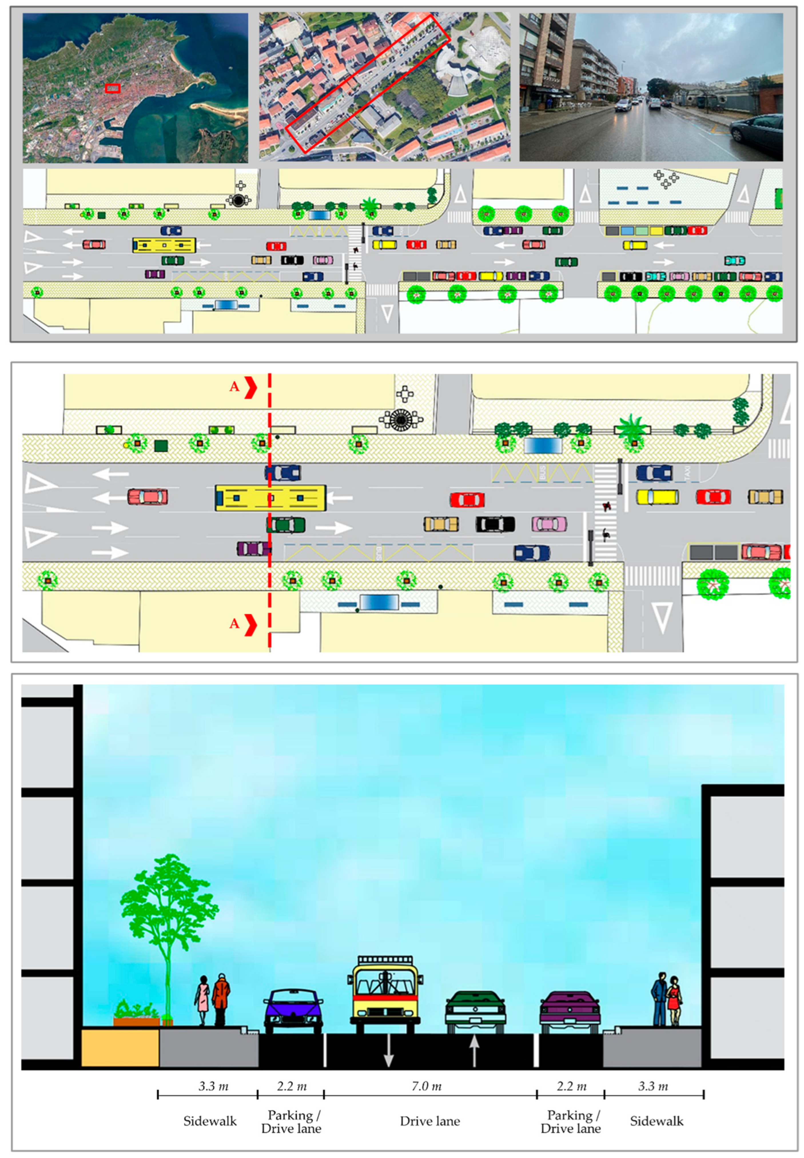
4. Adaptation of the Design Proposals to a European Case-Study

Given the lack of proposals for spatial areas other than American ones, we propose an example of an adaptation of these proposals to the European area for a real typical street. This urban design proposal can be applied to other streets with a similar profile, within the same street category. Considering that in Europe over 680 cities have between 50,000 and 250,000 inhabitants [22], an urban street in a medium-sized Spanish city has been selected. Santander is the capital of the northern region of Cantabria, and a main urban centre of an emerging metropolitan area with a total population of 173,375 inhabitants [71]. It is basically a compact and mixed city with a mainly service-based economy. Regarding urban mobility (including commuting), most citizens use private motorised transport (48%), or walk (42%) [72].
The chosen street, called Paseo del General Dávila, is an East-West communication axis which gives access to different areas of the city. The street is about 4 km long. It is located in one of the busiest areas of Santander and has an active economic and social life, with shops, parks and emblematic educational, health, cultural and administrative buildings. In the chosen section, the street is 18 m wide. Current street elements include two sidewalks, two parking lanes (becoming drive lanes when approaching the roundabout) and two drive lanes (Figure 1).
In a driverless future, the area freed from traffic and parking is proposed to be reconverted for other uses that prioritise design flexibility and elements linked to active mobility. The new street design includes a single narrower traffic lane, widening of the sidewalks, the incorporation of two cycle lanes and a flexible curb space (Figure 2). This flexible space increases the space available for other high-demand uses and can be segmented for multiple applications such as parklets, drop-off areas, bus stops, bike parking, or street furniture and trees, improving social life and economic vitality.

5. Conclusions

Since the second half of the 20th century, urban planning has focused on the dynamic dimension of public space, i.e., mobility, and more specifically on car mobility, rather than on the static part of public spaces dedicated to citizens’ activities. In recent years, we have seen how this situation is being reversed, with new urban models, such as the super-blocks model (Barcelona), the 15-minute city (Paris), or tactical urbanism interventions against COVID-19, that aim to recover public space for people, laying the grounds for urban planning goals that will guide the coming decades.
In response to the first of the questions posed, we have seen that the arrival of AVs can revolutionise mobility and urban systems, causing both positive and negative effects that can enhance sustainability, or repeat what happened with the automobile-dependent urban planning of decades ago, respectively. Several decisions, such as encouraging shared-used over privately-owned vehicles or the implementation of urban design strategies that promote active mobility are going to be crucial to guide the implementation of AVs in line with the urban objectives mentioned above.
In relation to the second question, we have found that the main positive effects of AVs on the urban space will be the reduction and lessening of traffic lanes, and especially the release of a large amount of space currently occupied by car parking. This gained space could amount to 10% to 27% of urban space, that could be reconverted to other uses focused on citizens’ needs and demands.
Despite the importance of addressing urban design in the advent of AVs, very few studies have been undertaken on this specific subject. There are only a few studies by researchers [19,21,62,73] and practitioners [20,48,63,70], in addition to the guidelines launched by NACTO [67,74], which present a vision of how to improve street design for the driverless city and set out concrete steps to be taken to ensure an equitable people-centred city.
Regarding the third question, and in line with new trends in urban planning, all these emerging design strategies for the driverless city are based on converting parking lanes and traffic space into flexible spaces devoted to people. These new spaces may include more green areas, parklets, and other elements, providing high-quality environments that attract citizens and which are essential to ensure the use of modern public spaces [25]. The other major goal of car space reconversion is to encourage active mobility modes, by doubling sidewalk space and creating bicycle lanes.
In general, most of the future proposals presented in the literature represent theoretical cases, and there are very few real case proposals aimed at rethinking the street, such as the contributions by Fortes [62] and Ruhl et al. [20]. In addition, all these studies are focused on the American context, and there is a lack of knowledge of the situation and possibilities in Europe and other spatial contexts. However, although redesign proposals may vary across countries or geographical regions, by building on the principles advocated by all these proposals for the future, planners can adapt urban spaces to prioritise people and enhance quality of life.
This revision shows the potential of AVs for transforming urban environments, but it also stresses the need to start planning now if citizen-friendly urban design strategies are to be implemented in a way that commits all stakeholders to pursuing a win-win model of AV implementation. Clearly, further research should be conducted to identify general design strategies and specific proposals in real case studies, especially in countries outside the American continent, and to establish comparisons between different geographical contexts and types of cities. Studies such as ours provide decision-makers with effective criteria and tools to implement informed design policies and to make informed decisions to guide the transformative actions needed in this field, so as to maximise the opportunities that AVs can bring and actually achieve more liveable and sustainable cities.

Author Contributions

Conceptualization, S.N. and E.G.-G.; methodology, S.N. and E.G.-G.; validation, S.N. and E.G.-G.; formal analysis, S.N. and E.G.-G.; investigation, M.F., S.N. and E.G.-G.; writing—original draft preparation, M.F., S.N. and E.G.-G.; writing—review and editing, S.N. and E.G.-G.; visualization, M.F. and E.G.-G.; supervision, S.N. and E.G.-G.; project administration, S.N.; funding acquisition, S.N. All authors have read and agreed to the published version of the manuscript.

Funding

This work is based on the research project “InnovAtive Urban and Transport planning tOols for the implemeNtation of new mObility systeMs based On aUtonomouS driving”–AUTONOMOUS, 2020–2023, funded by the Spanish Ministry of Science and Innovation/ERDF (EU)-State Programme for Knowledge Generation and Scientific and Technological Strengthening of the R&D&i System (PID2019-110355RB-I00).

Institutional Review Board Statement

Not applicable.

Informed Consent Statement

Not applicable.

Data Availability Statement

Not applicable.

Acknowledgments

A previous shortened version of this article has been presented to the first Conference on Future Challenges in Sustainable Urban Planning & Territorial Management (SUPTM 2022).

Conflicts of Interest

The authors declare no conflict of interest.

References

  1. Muller, P.O. Transportation and urban form: Stages in the spatial evolution of the American metropolis. In The Geography of Urban Transportation, 2nd ed.; Hanson, S., Ed.; Guilford: New York, NY, USA, 1995. [Google Scholar]
  2. Newman, P.; Kenworthy, J. Sustainability and Cities: Overcoming Automobile Dependence; Island Press: Washington, DC, USA, 1999. [Google Scholar]
  3. Czech, P.; Turoń, K.; Barcik, J. Autonomous vehicles: Basic issues. Sci. J. Sil. Univ. Technol. Ser. Transp. 2018, 100, 15–22. [Google Scholar] [CrossRef]
  4. Meyer, J.; Becker, H.; Bösch, P.M.; Axhausen, K.W. Autonomous vehicles: The next jump in accessibilities? Res. Transp. Econ. 2017, 62, 80–91. [Google Scholar] [CrossRef] [Green Version]
  5. Milakis, D.; van Arem, B.; van Wee, B. Policy and society related implications of automated driving: A review of literature and directions for future research. J. Intell. Transp. Syst. 2017, 21, 324–348. [Google Scholar] [CrossRef]
  6. Thomopoulos, N.; Givoni, M. The autonomous car—A blessing or a curse for the future of low carbon mobility? An exploration of likely vs. desirable outcomes. Eur. J. Futures Res. 2015, 3, 14. [Google Scholar] [CrossRef] [Green Version]
  7. González-González, E.; Nogués, S.; Stead, D. Parking futures: Preparing European cities for the advent of automated vehicles. Land Use Policy 2020, 91, 104010. [Google Scholar] [CrossRef]
  8. Milakis, D.; Snelder, M.; van Arem, B.; van Wee, B.; Correia, G. Development and transport implications of automated vehicles in the Netherlands: Scenarios for 2030 and 2050. Eur. J. Transp. Infrastruct. Res. 2017, 17, 63–85. [Google Scholar] [CrossRef]
  9. Hörl, S.; Ciari, F.; Axhausen, K.W. Recent Perspectives on the Impact of Autonomous Vehicles; Working paper Institute for Transport Planning and Systems (IVT); Institute for Transport Planning and Systems (IVT), ETH Zurich: Zurich, Switzerland, 2016; Volume 10XX. [Google Scholar] [CrossRef]
  10. Zhang, W.; Guhathakurta, S.; Fang, J.; Zhang, G. Exploring the impact of shared autonomous vehicles on urban parking demand: An agent-based simulation approach. Sustain. Cities Soc. 2015, 19, 34–45. [Google Scholar] [CrossRef]
  11. Fraedrich, E.; Heinrichs, D.; Bahamonde-Birke, F.J.; Cyganski, R. Autonomous driving, the built environment and policy implications. Transp. Res. Part A Policy Pract. 2019, 122, 162–172. [Google Scholar] [CrossRef] [Green Version]
  12. Cavoli, C.; Phillips, B.; Cohen, T.; Jones, P. Social and Behavioural Questions Associated with Automated Vehicles. A Literature Review; Department for Transport: London, UK, 2017. [Google Scholar]
  13. Zakharenko, R. Self-driving cars will change cities. Reg. Sci. Urban Econ. 2016, 61, 26–37. [Google Scholar] [CrossRef]
  14. Soteropoulos, A.; Berger, M.; Ciari, F. Impacts of automated vehicles on travel behaviour and land use: An international review of modelling studies. Transp. Rev. 2019, 39, 29–49. [Google Scholar] [CrossRef]
  15. Whitney, J. Autonomous Vehicles: How U.S. Cities are Preparing. Master’s Thesis, University of Oregon, Eugene, OR, USA, 2018. [Google Scholar]
  16. Freemark, Y.; Hudson, A.; Zhao, J. Are Cities Prepared for Autonomous Vehicles? J. Am. Plan. Assoc. 2019, 85, 133–151. [Google Scholar] [CrossRef]
  17. Nogués, S.; González-González, E.; Cordera, R. New urban planning challenges under emerging autonomous mobility: Evaluating backcasting scenarios and policies through an expert survey. Land Use Policy 2020, 95, 104652. [Google Scholar] [CrossRef]
  18. Heinrichs, D. Autonomous driving and urban land use. In Autonomous Driving: Technical, Legal and Social Aspects; Maurer, M., Gerdes, J.C., Lenz, B., Winner, H., Eds.; Springer: Berlin/Heidelberg, Germany, 2016; pp. 213–231. [Google Scholar] [CrossRef] [Green Version]
  19. Riggs, W.; Appleyard, B.; Johnson, M. A design framework for livable streets in the era of autonomous vehicles. Urban Plan. Transp. Res. 2020, 8, 125–137. [Google Scholar] [CrossRef] [Green Version]
  20. Ruhl, M.; Baumgardner, W.; Walker, J.; Peers, V. New Mobility Street Design: A Case Study of Autonomous Vehicles in San Francisco. In Proceedings of the 97th Transportation Research Board (TRB) Annual Meeting, Washington DC, USA, 7–11 January 2018. 18p. [Google Scholar]
  21. Schlossberg, M.; Riggs, W.W.; Millard-Ball, A.; Shay, E. Rethinking the Street in an Era of Driverless Cars; Technical Report; University of Oregon: Eugene, OR, USA, 2018. [Google Scholar]
  22. Gavanas, N. Autonomous Road Vehicles: Challenges for Urban Planning in European Cities. Urban Sci. 2019, 3, 61. [Google Scholar] [CrossRef] [Green Version]
  23. von Schönfeld, K.C.; Bertolini, L. Urban streets: Epitomes of planning challenges and opportunities at the interface of public space and mobility. Cities 2017, 68, 48–55. [Google Scholar] [CrossRef] [Green Version]
  24. Mehta, V. Evaluating Public Space. J. Urban Des. 2014, 19, 53–88. [Google Scholar] [CrossRef]
  25. Gehl, J.; Gemzøe, L. Winning back public space. In Sustainable Transport; Trolley, R., Ed.; Woodhead Publishing Limited: London, UK, 2003; pp. 97–106. [Google Scholar]
  26. Carmona, M. Principles for public space design, planning to do better. Urban Des. Int. 2019, 24, 47–59. [Google Scholar] [CrossRef] [Green Version]
  27. Carr, S.; Francis, M.; Rivlin, L.G.; Stone, A.M. Public Space; Cambridge University Press: New York, NY, USA, 1992. [Google Scholar]
  28. Krier, R. Urban Space; Academic Editions: London, UK, 1979; ISBN 0-85670-576-4. [Google Scholar]
  29. Stanley, B.W.; Stark, B.L.; Johnston, K.L.; Smith, M.E. Urban open spaces in historical perspective: A transdisciplinary typology and analysis. Urban Geogr. 2012, 33, 1089–1117. [Google Scholar] [CrossRef] [Green Version]
  30. Mantey, D.; Kępkowicz, A. Types of Public Spaces: The Polish contribution to the discussion of suburban public space. Prof. Geogr. 2018, 70, 633–654. [Google Scholar] [CrossRef]
  31. Hamilton-Baillie, B. Urban design: Why don’t we do it in the road? Modifying traffic behavior through legible urban design. J. Urban Technol. 2004, 11, 43–62. [Google Scholar] [CrossRef]
  32. Rodrigue, J.P. The Geography of Transport Systems, 5th ed.; Routledge: New York, NY, USA, 2020; 456p, ISBN 978-0-367-36463-2. [Google Scholar]
  33. Hall, P. The City on the Highway. The Automobile Suburb: Long Island, Wisconsin, Los Angeles, Paris, 1920-1987. In Cities of Tomorrow; Basil Blackwell Ltd.: Oxford, UK, 1988. [Google Scholar]
  34. Raikhel, Y.L.; Rozhdestvenskaya, E.S. Historical city center in the XX–XXI centuries: Back to pedestrian. OP Conf. Ser. Mater. Sci. Eng. 2020, 775, 012072. [Google Scholar] [CrossRef]
  35. Nieuwenhuijsen, M.J. New urban models for more sustainable, liveable and healthier cities post covid19; reducing air pollution, noise and heat island effects and increasing green space and physical activity. Environ. Int. 2021, 157, 106850. [Google Scholar] [CrossRef] [PubMed]
  36. Jasiński, A. COVID-19 pandemic is challenging some dogmas of modern urbanism. Cities 2022, 121, 103498. [Google Scholar] [CrossRef] [PubMed]
  37. Rueda, S. Superblocks for the design of new cities and renovation of existing ones: Barcelona’s case. In Integrating Human Health into Urban and Transport Planning: A Framework; Nieuwenhuijsen, M.H., Khreis, H., Eds.; Springer: Cham, Switzerland, 2019; pp. 135–153. [Google Scholar] [CrossRef]
  38. Vitale Brovarone, E.; Scudellari, J.; Staricco, L. Planning the transition to autonomous driving: A policy pathway towards urban liveability. Cities 2021, 108, 102996. [Google Scholar] [CrossRef]
  39. Moreno, C.; Allam, Z.; Chabaud, D.; Gall, C.; Pratlong, F. Introducing the “15-Minute City”: Sustainability, Resilience and Place Identity in Future Post-Pandemic Cities. Smart Cities 2021, 4, 93–111. [Google Scholar] [CrossRef]
  40. Capasso Da Silva, D.; King, D.A.; Lemar, S. Accessibility in practice: 20-minute city as a sustainability planning goal. Sustainability 2020, 12, 129. [Google Scholar] [CrossRef] [Green Version]
  41. Fenu, N. Bicycle and urban design. A lesson from COVID-19. Tema. J. Land Use Mobil. Environ. 2021, 14, 69–92. [Google Scholar]
  42. United Nations. People-Smart Sustainable Cities; United Nations Publications: New York, NY, USA, 2020. [Google Scholar]
  43. City of Portland. The Portland Plan; City of Portland, Oregon: Portland, OR, USA, 2012; Available online: https://www.portlandonline.com/portlandplan/index.cfm?c=56527 (accessed on 20 December 2021).
  44. Fields, B.; Renne, J.L. Adaptation Urbanism and Resilient Communities. Transforming Streets to Address Climate Change; Routledge: Abingdon, Oxfordshire, UK, 2021. [Google Scholar]
  45. Silva, P. Tactical urbanism: Towards an evolutionary cities’ approach? Environ. Plan. B Plan. Des. 2016, 43, 1040–1051. [Google Scholar] [CrossRef]
  46. Gutsch, M. Estimating the Potential Spatial Implications of Shared Autonomous Vehicles: A Case Study of Stockholm. Degree Project. In Technology. School of Architecture and the Built Environment; KTH Royal Institute Of Technology Stockholm: Stockholm, Sweden, 2018. [Google Scholar]
  47. Greenblatt, J.B.; Shaheen, S. Automated vehicles, on-demand mobility, and environmental impacts. Curr. Sustain. Renew. Energy Rep. 2015, 2, 74–81. [Google Scholar] [CrossRef] [Green Version]
  48. WSP|Parsons Brinckerhoff and Farrells. Making Better Places: Autonomous Vehicles and Future Opportunities. 2016. Available online: https://www.wsp.com/-/media/z-floating-images/Documents/UK/Making-better-places.pdf (accessed on 30 November 2021).
  49. Zhang, W. The Interaction between Land Use and Transportation in the Era of Shared Autonomous Vehicles: A Simulation Model. Ph.D. Thesis, Georgia Institute of Technology, Atlanta, GA, USA, 2017. [Google Scholar]
  50. Alessandrini, A.; Campagna, A.; Delle Site, P.; Filippi, F.; Persian, L. Automated vehicles and the rethinking of mobility and cities. Transp. Res. Procedia 2015, 5, 145–160. [Google Scholar] [CrossRef] [Green Version]
  51. Chester, M.; Horvath, A.; Madanat, S. Parking infrastructure and the environment. ACCESS Mag. 2011, 1, 28–33. [Google Scholar]
  52. Winter, K.; Cats, O.; Martens, K.; van Arem, B. Parking space for shared automated vehicles: How less can be more. Transp. Res. Part A Policy Pract. 2021, 143, 61–77. [Google Scholar] [CrossRef]
  53. Nourinejad, M.; Bahrami, S.; Roorda, M.J. Designing parking facilities for autonomous vehicles. Transp. Res. Part B Methodol. 2018, 109, 110–127. [Google Scholar] [CrossRef]
  54. Narayanana, S.; Chaniotakisb, E.; Antoniou, C. Shared autonomous vehicle services: A comprehensive review. Transp. Res. Part C 2020, 111, 255–293. [Google Scholar] [CrossRef]
  55. Zhao, L.; Malikopoulos, A. Enhanced Mobility with Connectivity and Automation: A Review of Shared Autonomous Vehicle Systems. IEEE Intell. Transp. Syst. Mag. 2020, 14, 87–102. [Google Scholar] [CrossRef] [Green Version]
  56. Metz, D. Developing Policy for Urban Autonomous Vehicles: Impact on Congestion. Urban Sci. 2018, 2, 33. [Google Scholar] [CrossRef] [Green Version]
  57. Schoettle, B.; Sivak, M. Potential Impact of Self-Driving Vehicles on Household Vehicle Demand and Usage; Report No. UMTRI-2015-3; University of Michigan Transportation Research Institute: Ann Arbor, MI, USA, 2015. [Google Scholar]
  58. Fagnant, D.J.; Kockelman, K.M. The travel and environmental implications of shared autonomous vehicles, using agent-based model scenarios. Transp. Res. Part C 2014, 40, 1–13. [Google Scholar] [CrossRef]
  59. Snyder, R. Implication of Autonomous vehicles: A planner’s perspective. Inst. Transp. Eng. ITE J. 2016, 86, 25–28. [Google Scholar]
  60. Garcia, A.; Camacho-Torregrosa, F.J. Influence of lane width on semi-autonomous vehicle performance. Transp. Res. Rec. 2020, 2674, 279–286. [Google Scholar] [CrossRef]
  61. Snyder, R. Street Design Implications of Autonomous Vehicles. Public Sq. A CNU J. 2018. Available online: https://www.cnu.org/publicsquare/2018/03/12/street-design-implications-autonomous-vehicles (accessed on 27 December 2021).
  62. Fortes, M.B. Tecnologias Disruptivas E Mobilidade Urbana: Inovações Para O Desenho Das Cidades. Ph.D. Thesis, Faculdade de Arquitetura e Urbanismo, Universidade de São Paulo, São Paulo, Brasil, 2020. [Google Scholar]
  63. Chapin, T.; Stevens, L.; Crute, J. Envisioning Florida’s Future: Transportation and Land Use in an Automated Vehicle World; Final report of Florida Department of Transportation (FDOT) contract BDV30 934-10, 2016; Florida Department of Transportation: Tallahassee, FL, USA, 2016. [Google Scholar]
  64. De Lara, S. The Driverless City. How will AVs Shape Cities in the Future? Ph.D. Thesis, OCAD University, Toronto, ON, Canada, 2020. [Google Scholar]
  65. Howell, A.; Chamberlain, K.L. (Eds.) Multilevel Impacts of Emerging Technologies on City Form and Development; Urbanism Next Center, Univeristy of Oregon: Eugene, OR, USA, 2020; Available online: https://cpb-us-e1.wpmucdn.com/blogs.uoregon.edu/dist/f/13615/files/2020/01/NSF-Report_All-Chapters_FINAL_013020.pdf (accessed on 20 December 2021).
  66. Mitman, M.F.; Davis, S.; Armet, I.B.; Knopf, E. Curbside Management Practitioners Guide; Institute of Transportation Engineers: Washington, DC, USA, 2018; Available online: https://www.ite.org/pub/?id=C75A6B8B-E210-5EB3-F4A6-A2FDDA8AE4AA (accessed on 20 December 2021).
  67. NACTO. Blueprint for Autonomous Urbanism Second Edition. Designing Cities; National Association of City Transportation Officials: New York, NY, USA, 2019; Available online: https://nacto.org/publication/bau2/ (accessed on 30 November 2021).
  68. Nappa, S. Autonomous Potential: Complete Streets in an Autonomous Vehicle Future; Professional Project Report; Master of Community and Regional Planning; University of Oregon: Eugene, OR, USA, 2018. [Google Scholar]
  69. Turoń, K.; Czech, P. The concept of rules and recommendations for riding shared and private e-scooters in road network in the light of global problems. In Modern Traffic Engineering in the System Approach to the Development of Traffic Networks; Macioszek, E., Sierpiński, G., Eds.; Springer: Cham, Switzerland, 2019; pp. 275–284. [Google Scholar] [CrossRef]
  70. FXcollaborative. Public Square. 2017. Available online: https://fxcollaborative.com/projects/186/public-square/ (accessed on 30 November 2021).
  71. INE. Municipal population data. Spanish Institute of Statistics. 2020. Available online: https://ine.es/dyngs/INEbase/es/operacion.htm?c=Estadistica_C&cid=1254736177011&menu=resultados&idp=1254734710990 (accessed on 20 December 2021). (In Spanish).
  72. Aloi, A.; Alonso, B.; Benavente, J.; Cordera, R.; Echaniz, E.; Gonzalez, F.; Ladisa, C.; Lezama-Romanelli, R.; Lopez-Parra, A.; Mazzei, V.; et al. Effects of the COVID-19 Lockdown on Urban Mobility: Empirical Evidence from the City of Santander (Spain). Sustainability 2020, 12, 3870. [Google Scholar] [CrossRef]
  73. Riggs, W.; Ruhl, M.; Rodier, C.; Baumgardner, W. Designing streets for autonomous vehicles. In Road Vehicle Automation 6; Meyer, G., Beiker, S., Eds.; Springer: Cham, Switzerland, 2019; pp. 111–122. [Google Scholar]
  74. NACTO. Blueprint for Autonomous Urbanism; National Association of City Transportation Officials: New York, NY, USA, 2017. [Google Scholar]
Figure 1. Current situation of Paseo del General Dávila, Santander (Spain). Plan view and cross- section A-A.
Sustainability 14 01568 g001
Figure 2. Adaptation of the design for an urban driverless street of a middle-sized European city. Paseo del General Dávila, Santander (Spain). Plan view and cross-section A-A.
Sustainability 14 01568 g002
Table 1. Street design proposals with AV.
Type of StreetCase StudyTotal Width (m)UnitDrive LaneParking LaneSidewalkCycle PathGreen SpaceOther/Flexible SpaceReferences
NowAVNowAVNowAVNowAVNowAVNowAV
Arterial/Collector/Urban-24.4N. lanes42 + PT *20220222Bollard+ Wayfinding signRiggs et al. (2020) [19]
01
m14.65.5 + 3.7 *4.903.77.603.71.2-00.9 + 1.2
%59.822.5 + 15.2 *20015.231.1015.25.0-03.7 + 5
-24.4N. lanes4120220223Parklet + Medians + BollardSchlossberg et al. (2018) [21]
01
m14.64.34.903.76.103.71.23.702.4 + 1.2 + 2.4 + 0.6
%59.817.620015.225015.2515.2027
San Francisco 4th Street24.4N. lanes4220220223Drop-off + Parking + BioswalesRuhl et al. (2018) [20]
01
m------0---0-
%------0---0-
São Paulo-Conselheiro Furtado24N. lanes4410220222Bollard+ Drop-offFortes (2020) [62]
1 + 00 + 1
m14.4142.6076.803.2--0.24-
%60581002927013--12
Florida21.2N. lanes4220220202MediansMedians + Drop-offChapin et al. (2016) [63]
12
m13.44.94.2037.303.701.80.61.2 + 4.3
%63.223.119.8014.234.4017.508.52.85.7 + 20
Local/Residential/Suburban-18.3N. lanes202022 ¤0¤21Shared spaceSchlossberg et al. (2018) [21]
02
m7.305.503.7¤0¤1.81107.3 ¤
%40030020¤0¤1060040 ¤
-18.3N. lanes202022¤0¤21Shared spaceRiggs et al. (2020) [19]
02
m7.305.503.7¤0¤1.89.109.1 ¤
%40030020¤0¤1050050 ¤
São Paulo-Rua Rodrigo Claudio17N. lanes222022022200Fortes (2020) [62]
m6.654.405.58.702.9--00
%39302703351017-100
- The authors do not mention the measures. * Reduce the number of drive lanes from four to three, two lanes for automobiles and one lane for public transport. ¤ Sidewalks are included in the shared/flexible space along with other possible uses.
Publisher’s Note: MDPI stays neutral with regard to jurisdictional claims in published maps and institutional affiliations.

