Article

Exploratory Spatial Analysis of Social Vulnerability and Forest Fire Risk in the Pinhal Interior Sul (Central Portugal)

1
University of Coimbra, Department of Geography and Tourism, Largo da Porta Férrea, 3004-530 Coimbra, Portugal
2
University of Coimbra, Centre of Studies in Geography and Spatial Planning (CEGOT), Department of Geography and Tourism, Largo da Porta Férrea, 3004-530 Coimbra, Portugal
*
Author to whom correspondence should be addressed.
Sustainability 2022, 14(5), 3010; https://doi.org/10.3390/su14053010
Submission received: 4 January 2022 / Revised: 24 February 2022 / Accepted: 28 February 2022 / Published: 4 March 2022

Abstract

:
Mainland Portugal is a Mediterranean country, particularly known for the recurrence of forest fires in terms of burnt areas, losses, and damage. The central Portugal administrative area has been in a “stage” of prominence for this dangerous phenomenon, with the sub-region Pinhal Interior Sul being one of the most critical territories. In addition to the manifestation of the dangerous process itself, it is important to state the importance of vulnerability, which has been relatively ignored in the definition of public policies in terms of spatial planning. Vulnerability concerns the way people and their assets are exposed to forest fires (as they represent the main targets of their harmful consequences), as well as how they are affected by, resist, and recover from them. This paper investigates only one of the components of vulnerability—social vulnerability—in terms of demographic, cultural, socio-economic, and infrastructural conditions to establish a comparative analysis among the parishes of the sub-region Pinhal Interior Sul (in particular, between the more urban and rural ones in each municipality). In the studied area, the high values of social vulnerability reinforce the high hazard level. At the municipality level, it is possible to conclude that the population living in more markedly rural and peripheral parishes is more vulnerable to forest fires than those living in the more urban conditions.

Graphical Abstract

1. Introduction

Due to the Mediterranean climate in which mainland Portugal is located [1,2,3,4], it is one of the most affected southern European countries in terms of forest fires [5,6,7,8,9,10,11,12,13]. The multi-decadal evaluation of forest fires evolution indicates an annual average of burnt area of 138,083 ha for Portugal, during the period from 2010 to 2019 [14]. From a national perspective, the central region possesses a considerable probability of forest fires [15,16], usually resulting in substantial losses (e.g., primary and second homes, businesses, forests, and agriculture), in addition to the loss of human lives. This scenario proves to be increasingly worrying in the context of climate change which, for the near future, indicates a significant increase in temperatures and a reduction in rainfall for the Mediterranean regions wherein Portugal resides [13,17].
For the central Portuguese administrative area, it is important to mention the fires of 2017 where 49,890 ha was burnt in the sub-region known as the Pinhal Interior Sul [18,19,20,21], promoting the biggest fire in terms of dimension ever registered (29,758 ha) in the Sertã municipality and in the parish of Várzea dos Cavaleiros [22]. The high vulnerability of its territory, along with a decreasing and constantly ageing population framed in rural and abandoned landscapes with an essential forest cover [12,23,24], has transformed Pinhal Interior Sul into one of the most problematic areas in terms of the consequences of forest fires in Portugal.
Social vulnerability, a concept that tries to interpret the predictable consequences regarding the population and the society of a certain undesirable natural phenomenon [25,26,27,28,29,30], is very little considered within public policies and spatial planning for the mitigation and management of risk. In practical terms, public policies related to the management of risk are indispensable on a par with territorial planning at any scale [31]. However, the lack of consideration for social vulnerability in the management of risks presents itself as an “obstacle” that calls into question the priority measures, which can be found as instruments in the National Spatial Planning Policy Program (Programa Nacional da Política do Ordenamento do Território—PNPOT), as well as in the Regional Program of Spatial Planning (Programa Regional de Ordenamento do Território—PROT) of central Portugal.
Demographically, the sub-region Pinhal Interior Sul is characterized by a gradual depopulation (−10.3% between 2011 and 2021) combined with substantial ageing (37.3% of the population over 65 years old), resulting in a difficult renovation of generations. In addition, the lack of opportunities results in a lack of interest among young people in fixating themselves in rural parishes, as they move to the localities that are the seat of the municipality or, more commonly, out of the municipality, usually to other regions or sub-regions with more job opportunities and better quality of life.
Consequently, elderly people can be considered as the most vulnerable group due to their economic conditions (low retirement funds); housing conditions (poorly built and old buildings); cultural conditions (many do not know how to read or write); and social conditions, such as women, who are expected to tale the role of caregivers for the older and younger family members (this last group being particularly dependent on the maternal “attitude”) [32].
The main goal of this study is to investigate the social vulnerability that composes the forest fire risk in the sub-region Pinhal Interior Sul (central Portugal), with the aim of contributing to the improvement of the spatial planning in this territory. Following this general goal, it aims to produce a prototype of social vulnerability map at the parish scale, as well as to establish a comparative analysis among parishes and identify the main challenges in the framework of the forest fire risk. It is also our aim to examine the relationship between the obtained social vulnerability mapping with the distribution of fires and burnt areas that occurred in the study area from 2010 to 2018, as well as to suggest some measures related to spatial planning, decreasing social vulnerability and, consequently, risks.

2. Theoretical Background
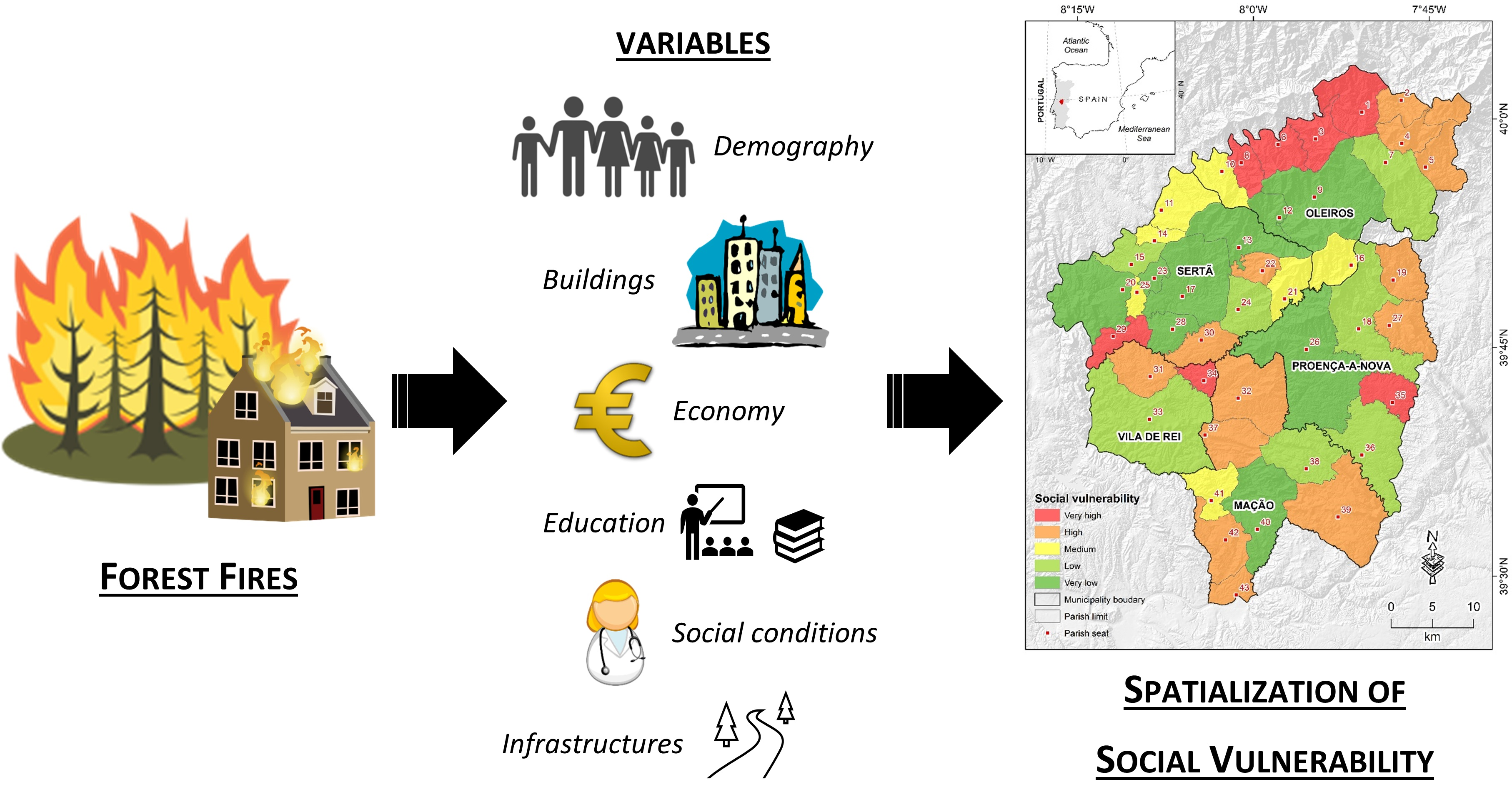
According to the United Nations Office for Disaster Risk Reduction (UNDRR) glossary, risk is the probability of an outcome having a negative effect on people, systems, or assets. Risk is typically depicted as being a function of the combined effects of a hazard, the assets or people exposed to a hazard, and the vulnerability of those exposed elements. In this investigation, considering that the main expected result is a cartographic model of social vulnerability that can be used by local/regional administrative authorities, it is preferred to use the definition of the National Authority for Civil Protection of Portugal, where the concept of risk is understood as the probability of occurrence of a dangerous process or action (hazard), and the respective estimation of its consequences on people, goods, or the environment, expressed in direct or indirect physical (bodily) harm and/or material damages (vulnerability), being evaluated according to the following equation: risk = hazard x vulnerability (adapted from [33]). This concept of risk encompasses every measure, or taken action, to anticipate the manifestation of a disaster. The study of risk is based on the acquired knowledge of the human being throughout their existence. In other words, based on the past and present, it is possible to enact and even predict what can happen in the future, always taking into consideration that a catastrophe, as a materialization of the risk, will always have a surprise dimension and carry some degree of uncertainty for most of the affected population [34].
Hazards and vulnerability are two sides of the same coin in this concept of risk, particularly in its mutual interrelationships [17,28,35,36,37,38,39]. In more detail, a hazard is related to the probability of the occurrence of eventually dangerous processes and can be subdivided into the probability/eventuality (temporal probability) and the susceptibility (spatial probability); the vulnerability largely determines the consequences of dangerous processes [40,41,42,43], implicating people’s degree of exposure and the value of their potentially affected assets/goods, as well as the community and people’s capacity for confrontation, resistance, and resilience (i.e., social vulnerability). In this context, the previously stated risk equation becomes more detailed: risk = (susceptibility × probability) × (social vulnerability × human exposure x economic value) [15]. However, this article only considers social vulnerability.
It is possible to evaluate a hazard through a few variables, such as the record of fires and their consequences, to understand both the temporal probability of its occurrence, as a rule related to weather conditions, and the conditioning factors of its spatialization, such as the land use, slope, road network, and water point network. These are the factors that allow us to justify the territorial differentiation of susceptibility. Vulnerability expresses the level of loss to which a certain element is susceptible given the occurrence of the hazard phenomenon, and it expresses itself, generally, on a scale ranging between 0 (no damage) and 1 (total damage), resulting in the destruction of the element at risk [44].
Peoples’ exposure adds to the exposure of their assets/goods, taking into consideration its economic, functional, and symbolic value with the potential effects of dangerous processes. In general terms, social vulnerability includes, besides criticality (which comprises a community’s demographic, social, economic, and cultural conditions) support capacity, which in some way is also interconnected with the exposure of assets (in other words, with the role of social and infrastructural equipment that support the society) [26]. Criticality is understood as the set of characteristics and behaviours of individuals that can contribute to the disruption of the system and the resources of communities that allow them to respond to or deal with catastrophic scenarios. Support capacity represents an economic question associated mainly with the existent support infrastructures, such as means of communication, healthcare facilities, schools, fire brigades, and churches, which allows the community to react in the event of a disaster or catastrophe.
According to [29], disasters, and therefore catastrophes, are always, in some way, social and not just the product of specific natural conditions. Social vulnerability’s components vary according to population and community characteristics (i.e., level of economic growth, access to resources, culture, and lifestyle), as well as the livelihoods of the affected people and groups. The cartographic analysis and representation of social vulnerability may aim to promote public policies and institutional practices “against discriminatory dynamics” [45]. In other words, it avoids the development of extremely unequal societies (both economically and socially) [34,46]. In the case study, this was applied in particular to vulnerable groups such as children, women, and an extremely aged population in accentuated poverty conditions (which also refers to poor conditions in terms of education and culture). Thus, social vulnerability is not just about combat and resistance, but also considers the structural conditions of communities and territories that allow recovery after forest fires [4,34,46].
In Portugal, forest fires have a predominantly anthropic origin [47], and only after both fire behaviour and its destructive character are influenced by natural processes/factors [22]. Conditioning factors of forest fire hazard, such as weather, regional physiography, and moisture content of the combustible favourable to fire deflagration, are distinguished from triggers [48,49,50,51], such as natural weather conditions (thunders) or anthropical circumstances (i.e., negligence, accidents, and crimes) [52].
Forest fires are nothing more than the existence of uncontrolled and undesired fires within a forested perimeter [53]. Their genesis originates from the ignition of fire in a forested perimeter under favourable conditions to their propagation. Among them, we can highlight the lack of forest management, low moisture content of fine combustibles, steep slopes, insolation in southern-facing slopes (lower air humidity levels), etc.
It should be noted that forest fires often spread beyond the forest perimeter, covering other types of land cover such as agricultural areas and even built spaces. Therefore, the forest urban interface plays a major role in terms of management and action in the protection of individuals and their assets/goods [42].
In short, forest fire risk cannot only be seen through the probability of occurrence, but also through its potential adverse consequences for society [28,54,55]. This is to say that it implies, necessarily, an approach to vulnerability, or the probability of occurrence of the negative repercussions of fires (material or human losses).

3. Study Area

The sub-region Pinhal Interior Sul is situated in the central Portugal administrative area, integrating five municipalities, namely, Oleiros, Proença-a-Nova, Sertã, and Vila de Rei, in the district of Castelo Branco, and, lastly, the municipality of Mação, in the district of Santarém. Forty-three parishes cover the entire study area (Figure 1).
In Portugal, the rural territories of inland, as the study area, are nothing more than the “mirror” of the “demographic transition phenomena”, which resulted in the economic and social transformations that have occurred since the 1960s and 1970s (i.e., migrations to coastal areas, to larger urban centres, and abroad, and even the declining birth rate) [56]. When it comes to the inland municipalities, we have been witnessing a strong decrease in the population in recent decades, explained not only by “inter-municipal movements” but also by the general abandonment of rural areas. Depopulation is nothing more than the reality of traditional rural areas, which is also described by its immediate consequences, such as agricultural land abandonment due to the lack of workforce and low income on the part of this field of activity. Figure 2 shows that the parishes of the study area corresponding to the seats of the municipalities (no. 9, 17, 26, 33, and 40) register higher numbers of residents per km², highlighting the parishes of Sertã (no. 17) and Mação (no. 40). This is justified since it is in the seat of the municipalities, as in some parishes around them, in which a higher amount of goods and services associated with the economic activity are concentrated (with the predominance of the tertiary sector).
In contrast, the more rural and peripherical parishes, such as Marmeleiro (no. 30), Amêndoa (no. 37), São João do Peso (no. 34), São Pedro do Esteval (no. 36) and Isna (no. 16), are characterized by low dynamism of economic activities associated with the tertiary sector where there are low rates of job offers, making them unattractive to young people (as well as resulting in poor agroforest activities dynamism).
Regarding the forest fires of the study area, in the period from 2010 to 2018 [58], we can see that the greater extent of the burnt area (49,890 ha) was created in 2017 (Figure 3), due to the particularly adverse weather conditions that affected every parish belonging to the sub-region Pinhal Interior Sul.

4. Materials and Methods

The statistical data used to evaluate social vulnerability for the study area were collected from the Geographical Database for Referencing (BGRI database http://mapas.ine.pt/download/index2011.phtml; accessed on 15 October 2020), as well as from the Contemporaneous Portugal Database (PORDATA—https://www.pordata.pt/; accessed on 15 October 2020). Both data sources refer to the year 2011, and all of the information was collected at the parish scale. The BGRI database was chosen since it is easy to use and for its articulation with georeferenced spatial data (e.g., limits of municipalities and parishes). In addition, due to the general scarcity of data available in Portugal at the parish scale, more specifically regarding determining the support capacity, information on the 24-h service chemists’ website (https://www.farmaciasdeservico.net/; last accessed on 15 October 2020) was also gathered from municipal social maps that are made up of three distinct parts: (i) the social diagnosis; (ii) the social development plan; and (iii) the action plan. Social diagnosis is used as an instrument for identifying priority needs and problems, as well as the resources, potentialities, and constraints of each territory. The social development plan, based on the priorities defined in the social diagnosis, determines intervention axes and strategic objectives, which are in turn operationalized through an annual action plan. Now, many of the municipalities in Portugal have a social map as a tool to aid in municipal planning. The road density was obtained from primary, secondary, and tertiary road-length line-vector data (in a geographic information system—GIS).
The reduced amount of information that could be gathered at the parish scale meant that it was not possible to carry out a separate calculation for criticality and support capacity, but to include all of the data regarding both in the calculation of a general index of social vulnerability that would take into consideration the integration of these two features.
Considering the available statistical data, a set of variables was chosen to assess the social vulnerability of the study area. To avoid redundancy in the information of the variables, the initial number was reduced using a correlation matrix containing 35 variables, of which only 31 were selected (Table 1). The SoVI method [25,26,41], which was adapted according to the type of risk (forest fire), the nature/scale of the study area, and the data availability, was then applied.
This set of thirty-one variables, distributed among six main categories (Table 1), contribute in different ways to increasing the negative effects and economic losses due to forest fires, thus raising the vulnerability of the individuals and communities. In some cases, the chosen variables concern more general aspects related to the exposure of people and goods, such as population density and building density. In other cases, these are variables that concern the way in which the population can face forest fire situations, contributing to their early warning, to a first confrontation of the flames, and to the direct protection of their goods—this is the case for variables such as the proportion of women, the youth de-pendency index, and the proportion of the employed population, among others. Other chosen variables are related to the age, poverty, and illiteracy conditions of the population, which makes it especially difficult for them to recover after economic losses related to forest fires. Examples of these types of variables are the proportion of the aging population, the number of old or recent buildings, and the proportion of employees and retirees, as well as the proportion of individuals who cannot read or write. However, the general state of preparation of the territories seen, for example, through the number of pharmacies or roads, can also contribute to raising social vulnerability when they are insufficient and/or poorly spatially distributed.
After the selection of these 31 variables, the factorial analysis on SPSS 25 software was performed, from which the KMO (Kaiser–Meyer–Olkin measure—sample suitability) value was 0.61. This value, between 0.6 and 0.7, falls under the category of reasonable significant values, and therefore, principal component analysis could be carried out [59]. The Bartlett test was also performed, which returned good results, in accordance with the communality one [59]. Using factorial analysis, ten factors were obtained, from which we excluded the last one from the calculation of vulnerability once it presented a weak correlation with any of the selected variables.
Subsequently, the social vulnerability index (SVI), for each territorial unit under consideration (parish), was applied. This was based on the sum of the values of the scores of each territorial unit for each factor, weighted by the percentage of the explained variance by each of the factors and signalled positively or negatively according to their relevance (positive or negative in the increment in social vulnerability), as shown in the following expression:
SVI = − F1 × Var (F1) + F2 × Var (F2) + F3 × Var (F3) − F4 × Var (F4) + F5 × Var (F5) − F6 × Var (F6) − F7 × Var (F7) − F8 × Var (F8) − F9 × Var (F9)
where Fn = principal components analysis resulting factors, such as Fn = 1…9; Var (Fn) = percentage of the variance explained by the factors, such as Fn = 1…9.
Finally, after applying the expression (1), a cartography regarding the spatialization of social vulnerability, sorted by parishes, was made using GIS tools (namely ESRI’s ArcGIS 10.7.1 software). The natural-breaks classification procedure was used to create the intervals between classes of social vulnerability: very high (red), high (orange), medium (yellow), low (light green), and very low (dark green). These five classes were based on natural groupings inherent in the data (GIS software identified break points by picking class breaks that best grouped similar values and maximised the differences between classes), and the features were divided into classes with boundaries that were set when there were relatively large jumps in the data values.
It is also worth noting that a dispersion graph regarding the crossing of the principal factors (Factors 1 and 2) was made using a Microsoft Excel spreadsheet.

5. Results and Discussion

Table 2 shows the results of factorial analysis where the nine factors (percentage of the total explained variance), the correlation with the dominant variable, and the direction of this correlation are shown. These nine factors, which explain 79.2% of the total variance, were considered for the study of social vulnerability in the sub-region Pinhal Interior Sul, among which Factor 1 is worth highlighting, which explains 27.6% of the variance; has a −0.9 correlation with the dominant variable (the proportion of the elderly population); and relates negatively to the percentage of the retired population. Factor 2 is related to families with no unemployed members which, naturally, suggests a better economic condition and therefore less vulnerability. Factor 3 is related to the percentage of women in the population and reflects both the aging process (women have a longer life expectancy) and internal/foreign migratory processes. The greater the proportion of women, the more fragile the family will be, both in the process of resistance and in the recovery from forest fires. Factor 4 is directly related to the health conditions of the inhabitants, but it is also a sign of the social and economic development of the parishes, which reduces the vulnerability of the populations.
Furthermore, regarding the comparison between Factors 1 and 5 (Table 2), these two variables should be strongly correlated. However, the ageing index refers to the proportion of the elderly population (aged 65 years and over) per 100 individuals younger than 14 years old in a specific population. Practically, it is a tool to measure the untapped potential of older people for active and healthy aging in a society. The difference between the percentage of elderly people and the ageing rate of a population may seem subtle, but they have different meanings. In the case under study, the numbers of the ageing index are more discrepant than the numbers of the percentage of elderly people in relation to the average values of central Portugal and the country as a whole.
Hence, Factor 1 concerns demographical characterization where the young population means a contribution to the generational turnover, the interior being “known” by its ageing population. The higher scores in this factor occur, logically, in the parishes of Sertã (no. 17), Proença-a-Nova (no. 26), and Oleiros (no. 9), as well as in other less rural parishes (i.e., with better infrastructures and more developed from a socio-economic point of view). Cernache de Bonjardim (no. 20) and Cabeçudo (no. 23) (Figure 4) are, in the context of the study area, the parishes with a higher young population percentage, which can be explained by the existence of a set of conditions regarding education, health, and housing.
Regarding Factor 2, it can be observed that the parishes that are the seat of municipalities, such as Oleiros (no. 9), Proença-a-Nova (no. 26), and Sertã (no. 17), along with other less rural parishes, such as Amieira (no. 3), Cambas (no. 1) and Isna (n. 16), have a lower percentage of unemployed individuals (Figure 4), which means that there is a better development of economic activities, especially in the tertiary sector (the main employment creators). However, the rural parishes have high levels of unemployment, which reveals the weak dynamism of the activities of the primary sector.
In short, it can be observed that the parishes that are the seat of the municipalities, such as Sertã (no. 17), Oleiros (no. 9) and Proença-a-Nova (no. 26), are better positioned when related to the two most important factors once they register a better socio-economic dynamism. On the other hand, parishes such as Palhais (no. 29) and Vilar Barroco (no. 4), the most peripherical and truly rural parishes, register a least a favourable position given the low economic power, decayed housing stock, aged population, and active population professional structure (which is largely based on the primary sector).
It can be observed in Figure 5 that the seats of the municipalities have the lowest values of social vulnerability in relation to the other parishes. In a decreasing order, we can highlight Sertã (no. 17), Oleiros (no. 9), Proença-a-Nova (no. 26), Mação (no. 40), and Vila de Rei (no. 33). Despite not being the seat of a municipality, Cernache do Bonjardim (no. 20) has a very low value of social vulnerability, which can be explained by the fact that it is a town with characteristics, functions, and equipment identical to the town of Sertã (no. 17), which is even better positioned than Vila de Rei (no. 33). Other less rural parishes, such as Mosteiro (no. 12), Troviscal (no. 13), Cabeçudo (no. 23), and Cumeada (no. 28) also have very low levels of social vulnerability, followed by low levels in the parishes of Estreito (no. 7), Castelo (no. 15), Várzea dos Cavaleiros (no. 24), São Pedro do Esteval (no. 36), and Sobreira Formosa (no. 18). In the case of the parish of Várzea dos Cavaleiros (no. 24), the low level of social vulnerability is tied to the fact that, on the other hand, there are several kindergartens which are not present in other rural parishes (more favourable levels of social vulnerability, e.g., Palhais—no. 29). This is explained by the fact that it is in the seat of the municipalities in which the main economic activities, but also the main social infrastructures (i.e., the nursing homes, the chemists, the schooling centres, the kindergartens and the pre-schooling centres, the fire stations, etc.) are found. Combined with the main elements that characterize the support capacity, there are local features when it comes to criticality that justify these levels, such as the greater concentration of the young population and the existence of services tied to the tertiary sector, which are areas that attract people from peripherical parishes who end up finishing their studies in the seat of the municipality where they live (or even out of them in medium-sized cities in the case of higher education).
The parishes of Orvalho (no. 2), Vilar Barroco (no. 4), Sarnadas de São Simão (no. 5), Figueiredo (no. 22), Marmeleiro (no. 30), Fundada (no. 31), Penhascoso (no. 42), Ortiga (no. 43), Amêndoa (no. 37), Cardigos (no. 32), Envendos (no. 39), Montes de Senhora (no. 27), and Alvitos da Beira (no. 19) have high levels of social vulnerability (Figura 5). These levels can be mostly explained by the increase in the ageing index along with the fact that the economic activities are based on the primary sector. However, the low income and the lack of state support for agroforestry activities mean that most adults and the young population are not interested in these activities, seeking their sustenance in other activities and in other territories.
Some parishes of the Oleiros municipality, such as Sobral (no. 8), Álvaro (no. 6), Amieira (no. 3), and Cambas (no. 1) have a very high level of social vulnerability, being the most vulnerable compared to the other ones despite Palhais (no. 29), São João do Peso (no. 34), and Peral (no. 35) also having highly significant values (Figure 5). These values, which reflect high social vulnerability, and the differentiation of its levels among the parishes of the sub-region Pinhal Interior Sul (Figure 5), show the fragility of the population against natural forest fire events, which are the main environmental risk at the regional scale, especially in the most peripherical and rural parishes. This fragility of the population means that the resistance to forest fires, as well as the recovery after them, is therefore seriously compromised both at the socioeconomic and territorial levels.
In terms of the methodological approach used, it allows us to effectively describe the levels of social vulnerability that affect one of the most impoverished, depopulated, and aged territories in the inland of Portugal. The cartographic results achieved (Figure 5), especially at the comparative scale of parishes, will allow local/regional public authorities to intervene differently and to target the specific problems of each area. However, it is also important to highlight that the used method has some limitations. Indeed, starting from an initial set of variables, the factor analysis seeks to synthesize and identify a smaller set of hypothetical variables (factors) [59], although these factors have a much more complex perception than the initial variables, making their practical use in solving problems difficult. The absence of some data sources for specific variables considered important (these being the most expressive example of per capita income) should also be mentioned. In fact, in Portugal there are few data at the parish scale (and more specifically regarding the territorial conditions), which make it impossible to calculate social vulnerability in the two separated parts (i.e., criticality and support capacity). On the other hand, the detailed cartography carried out at the parish scale establishes territorial generalizations that are sometimes difficult to apply to a phenomenon such as a forest fire, which is relatively discontinuous from a spatial point of view.
Finally, the transformations registered in the last 50/60 years in Portugal, namely in the rural areas of its inland—such as the sub-region Pinhal Interior Sul—were responsible for agricultural abandonment, as well as for the proliferation of forest and bush spaces, which are almost always poorly organized and poorly managed. This transformation is related to depopulation and the progressive aging of the population, which is increasingly exposed and more vulnerable to forest fires. In this scenario, this investigation made it possible to develop an applicative study on social vulnerability for a critical area in terms of forest fires at an analytical and spatial scale (parishes) never used before. Furthermore, this study provides the possibility of verifying how this vulnerability increases the fire risk in the territory under investigation, as well as defining new proposals of public policies based on a reduction in vulnerability.

6. Conclusions

The current study focuses on the relevance of social vulnerability at the parish scale, from which it is possible to highlight its spatial differentiation in a way that enables adequate social intervention when it comes to public policies.
The methodological approach used here to analyse the social vulnerability of the sub-region Pinhal Interior Sul (central Portugal) at the parish scale, and the cartographic results obtained, are aimed at helping to define and put into practice policies that envisage the mitigation of risk in this territory. Thus, in envisaging addressing the high and very high levels of social vulnerability at the parish scale, some medium- to long-term measures are proposed in the context of public policies targeting risk mitigation (namely the risk of forest fire, probably one of the most significant risks in the study area). Among the measures proposed are the following:
(1)
Creating and installing companies to manage forest combustibles, which would, in turn, create job opportunities, as well as creating professionalizing courses associated with this sector of economic activity;
(2)
Reinforcement of the municipal capacity to intervene in the management of the combustible containment strips on private pieces of land;
(3)
Promote a decrease in the unemployment rate and promote access to human resources;
(4)
Re-installation or replacement of infrastructure, as well as social and economic services that were being removed as the population declines;
(5)
Promote technical and academic studies on forest fire risk, which are of economic value to forests and help to create measures to reduce and mitigate the risk.
These measures should be integrated into public policies at the regional and municipal levels to promote forest management and develop prevention and rescue services. The foreseeable reduction in hazards, which is necessary in the context of climate change that we are experiencing, will have to be accompanied by measures to reduce vulnerability, such as the installation of services, job creation, population retention, and the development of rural tourism. Only in this way will it be possible to reverse a process of territorial degradation that has been going on for more than half a century, but one that seems, today more than ever, possible, necessary, and urgent.

Author Contributions

Conceptualization, L.C.; data curation, J.F. and L.C.; formal analysis, J.F., L.C. and L.A.D.; funding acquisition, L.C. and L.A.D.; investigation, J.F. and L.C.; methodology, J.F., L.C. and L.A.D.; supervision, L.C.; visualization, L.C. and L.A.D.; writing—original draft, J.F., L.C. and L.A.D.; writing—review and editing, J.F., L.C. and L.A.D. All authors have read and agreed to the published version of the manuscript.

Funding

This research was supported by national funds through FCT—Foundation for Science and Technology, I.P., within the scope of the strategic project UIDB/04084/2020 (CEGOT).

Institutional Review Board Statement

Not applicable.

Informed Consent Statement

Not applicable.

Data Availability Statement

Not applicable.

Acknowledgments

The editor and anonymous reviewers are gratefully acknowledged for their constructive assessments, which helped to improve the manuscript.

Conflicts of Interest

The authors declare no conflict of interest.

References

  1. Daveau, S.; Coelho, C.; Costa, V.G.; Carvalho, L. Répartition et Rythme des Précipitations au Portugal; Memórias do Centro de Estudos Geográficos; Centro de Estudos Geográficos: Lisbao, Portugal, 1977; pp. 1–192. [Google Scholar]
  2. Medeiros, C. Geografia de Portugal. o Ambiente Físico; Círculo de Leitores: Lisboa, Portugal, 2005; Volume 1. [Google Scholar]
  3. Hirschberger, P. FORESTS ABLAZE Causes and Effects of Global Forest Fires; WWF: Berlin, Germany, 2016. [Google Scholar]
  4. Oliveira, S.; Félix, F.; Nunes, A.; Lourenço, L.; Laneve, G.; Sebastián-López, A. Mapping wildfire vulnerability in Mediterranean Europe. Testing a stepwise approach for operational purposes. J. Environ. Manag. 2018, 206, 158–169. [Google Scholar] [CrossRef] [PubMed]
  5. San-Miguel-Ayánz, J.; Moreno, J.M.; Camia, A. Analysis of large fires in European Mediterranean landscapes: Lessons learned and perspectives. For. Ecol. Manag. 2013, 294, 11–22. [Google Scholar] [CrossRef]
  6. Tedim, F.; Remelgado, R.; Martins, J.; Carvalho, S. The largest forest fires in Portugal: The constraints of burned area size on the comprehension of fire severity. J. Environ. Biol. 2015, 36, 133–143. [Google Scholar]
  7. Nunes, A.; Lourenço, L.; Castro Meira, A.C. Exploring spatial patterns and drivers of forest fires in Portugal (1980–2014). Sci. Total Environ. 2016, 573, 1190–1202. [Google Scholar] [CrossRef] [PubMed]
  8. Turco, M.; Bedia, J.; Di Liberto, F.; Fiorucci, P.; von Hardenberg, J.; Koutsias, N.; Provenzale, A. Decreasing fires in Mediterranean Europe. PLoS ONE 2016, 11, e0150663. [Google Scholar] [CrossRef] [Green Version]
  9. Oliveira, S.; Zêzere, J.L.; Queiros, M.; Pereira, J.M. Assessing the social context of wildfire-affected areas. The case of mainland Portugal. Appl. Geogr. 2017, 88, 104–117. [Google Scholar] [CrossRef]
  10. Castro Meira, A.C.; Nunes, A.; Sousa, A.; Lourenço, L. Mapping the Causes of Forest Fires in Portugal by Clustering Analysis. Geosciences 2020, 10, 53. [Google Scholar] [CrossRef] [Green Version]
  11. Oliveira, S.; Gonçalves, A.; Zêzere, J.L. Reassessing wildfire susceptibility and hazard for mainland Portugal. Sci. Total Environ. 2021, 762, 143121. [Google Scholar] [CrossRef]
  12. Cunha, L. (Physical) Geography and Environmental Issues in Portugal. In Geographies of Mediterranean Europe; Lois-González, R.C., Ed.; Springer Geography: Berlin/Heidelberg, Germany, 2021; pp. 105–120. [Google Scholar]
  13. Busico, G.; Giuditta, E.; Kazakis, N.; Colombani, N. A Hybrid GIS and AHP Approach for Modelling Actual and Future Forest Fire Risk Under Climate Change Accounting Water Resources Attenuation Role. Sustainability 2019, 11, 7166. [Google Scholar] [CrossRef] [Green Version]
  14. EC. Forest Fires in Europe, Middle East and North Africa 2020; Publications Office: Luxembourg, 2021. Available online: https://publications.jrc.ec.europa.eu/repository/handle/JRC126766 (accessed on 23 February 2022).
  15. Dimuccio, L.; Ferreira, R.; Cunha, L.; Campar, A. Regional forest fire susceptibility analysis in central Portugal using a probabilistic ratings procedure and artificial neural network weights assignment. Int. J. Wildland Fire 2011, 20, 776–791. [Google Scholar] [CrossRef]
  16. Oliveira, S.; Bergonse, R.; Pinto Santos, P.; Gonçalves, A.; Melo, R.; Zêzere, J.L. Avaliação de Risco de Incêndios à escala local na região Centro de Portugal. In Geografia, Riscos e Proteção Civil. Homenagem ao Professor Doutor Luciano Lourenço; Nunes, A., Amaro, A., Vieira, A., Velez de Castro, F., Félix, F., Eds.; RISCOS—Associação Portuguesa de Riscos, Prevenção e Segurança: Coimbra, Portugal, 2021; Volume 2, pp. 79–89. [Google Scholar]
  17. Ghorbanzadeh, O.; Blaschke, T.; Gholamnia, K.; Aryal, J. Forest Fire Susceptibility and Risk Mapping Using Social/Infrastructural Vulnerability and Environmental Variables. Fire 2019, 2, 50. [Google Scholar] [CrossRef] [Green Version]
  18. ICNF. 10° Relatório Provisório de Incêndios Florestais—01 de Janeiro a 31 Outubro 2017 (Lisboa). Available online: http://www2.icnf.pt/portal/florestas/dfci/relat/rel-if/2017 (accessed on 15 October 2020).
  19. Fernandes, S.; Lourenço, L. Grandes incêndios florestais de Março, Junho e Outubro (fora do período crítico) em Portugal Continental. Territorium 2019, 26, 15–34. [Google Scholar] [CrossRef]
  20. Lourenço, L.; Félix, F. As vagas de incêndios florestais de 2017 em Portugal Continental, premissas de uma quarta ‘geração’? Territorium 2019, 26, 35–48. [Google Scholar]
  21. Turco, M.; Jerez, S.; Augusto, S.; Tarín-Carrasco, P.; Ratola, N.; Jiménez-Guerrero, P.; Trigo, R.M. Climate drivers of the 2017 devasting fires in Portugal. Sci. Rep. 2019, 9, 13886. [Google Scholar] [CrossRef]
  22. Viegas, X. Análise dos Incêndios Florestais Ocorridos a 15 de Outubro de 2017. Centro de Estudos sobre Incêndios Florestais, ADAI/LAETA; Departamento de Engenharia Mecânica, Faculdade de Ciências e Tecnologias, Universidade de Coimbra: Coimbra, Portugal, 2019. [Google Scholar]
  23. Almeida, A.C. Rural abandonment and landscape evolution in the central region of Portugal. In International Geographical Union: Issues in Geographical Marginality—Papers Presented during the Commission Meetings 2001–2004: Demographic Problems; Jones, G., Leimgruber, W., Nel, E., Eds.; Rhodes University: Makhanda, South Africa, 2007; pp. 53–63. [Google Scholar]
  24. Farinha, J. Território, Vulnerabilidade e Risco: Os Incêndios Florestais No Pinhal Interior Sul. Master’s Dissertation, Universidade de Coimbra, Coimbra, Portugal, 2020. [Google Scholar]
  25. Cutter, S.L.; Boruf, B.J.; Shirley, W.L. Social vulnerability to environmental hazards. Soc. Sci. Q. 2003, 84, 242–261. [Google Scholar] [CrossRef]
  26. Mendes, J.; Tavares, A.; Cunha, L.; Freiria, S. A vulnerabilidade social aos perigos naturais e tecnológicos em Portugal. Rev. Crít. Ciênc. Soc. 2011, 40, 95–128. [Google Scholar] [CrossRef] [Green Version]
  27. Cunha, L.; Mendes, J.; Tavares, A.; Freiria, S. Construção de modelos de avaliação de vulnerabilidade social a riscos naturais e tecnológicos. O desafio das escalas. In Trunfos de uma Geografia Ativa. Desenvolvimento Local, Ambiente, Ordenamento e Tecnologia; Santos, N., Cunha, L., Eds.; Imprensa da Universidade de Coimbra: Coimbra, Portugal, 2011; pp. 627–637. [Google Scholar]
  28. Cutter, S. A ciência da vulnerabilidade: Modelos, métodos e indicadores. Risco, vulnerabilidade social e cidadania. Rev. Crít. Ciênc. Soc. 2011, 93, 59–69. [Google Scholar] [CrossRef] [Green Version]
  29. Mendes, J. Sociologia do Risco–Uma Breve Introdução e Algumas Lições; Imprensa da Universidade de Coimbra: Coimbra, Portugal, 2015. [Google Scholar]
  30. Fischer, A.P.; Frazier, T.G. Social vulnerability to climate change in temperate forest areas: New measures of exposure, sensitivity, and adaptive capacity. Ann. Am. Assoc. Geogr. 2018, 108, 658–678. [Google Scholar] [CrossRef]
  31. Tavares, A. Riscos naturais e ordenamento do território—Modelos, práticas e políticas públicas a partir de uma reflexão para a Região Centro de Portugal. Prospect. Planeam. 2010, 17, 33–55. [Google Scholar]
  32. Jones, L. Os Grandes Desastres—Como os Desastres Naturais Nos Moldaram e o que Podemos Fazer para Os Prevenir; Vogais: Granja-Vialonga, Portugal, 2019. [Google Scholar]
  33. Julião, R.; Nery, F.; Ribeiro, J.; Branco, M.; Zêzere, J. Guia Metodológico para a Produção de Cartografia Municipal de Risco e para Criação de Sistemas de Informação Geográfica (SIG) de Base Municipal; Autoridade Nacional de Proteção Civil: Lisboa, Portugal, 2009.
  34. Beck, U. Sociedade de Risco. Rumo a uma Outra Modernidade; Editora 34: São Paulo, Brasil, 2010. [Google Scholar]
  35. Cunha, L. Vulnerabilidade: A face menos visível do estudo dos riscos naturais. In Homenagem ao Professor Fernando Rebelo; Lourenço, L., Mateus, M., Eds.; Departamento de Geografia, Faculdade de Letras da Universidade de Coimbra: Coimbra, Portugal, 2013; pp. 153–165. [Google Scholar]
  36. Cunha, L. Vulnerabilidade e riscos naturais: Exemplos em Portugal. In Vulnerabilidade e Riscos: Reflexões e Aplicações na Análise do Território; Freitas, M.I.C., Lombardo, M.A., Zacharias, A.A., Eds.; CEGOT e Departamento de Geografia, Universidade de Coimbra: Coimbra, Portugal, 2016; pp. 55–62. [Google Scholar]
  37. Bento-Gonçalves, A.; Vieira, A.; Nunes, A.; Lourenço, L.; Oliveira, S.; Félix, F. Análise de vulnerabilidade a incêndios florestais na região do Minho, Portugal. In III Congresso Internacional, I Simpósio Ibero-Americano, VII Encontro Nacional de Riscos, Guimarães; Associação Portuguesa de Riscos, Prevenção e Segurança: Coimbra, Portugal, 2014; pp. 721–725. [Google Scholar]
  38. de Diego, J.; Rúa, A.; Fernández, M. Vulnerability Variables and Their Effect on Wildfires in Galicia (Spain). A Panel Data Analysis. Land 2021, 10, 1004. [Google Scholar] [CrossRef]
  39. Thywissen, K. Components of Risk: A Comparative Glossary; UNU-EHS: Bonn, Germany, 2006. [Google Scholar]
  40. Guillard-Gonçalves, C.; Zêzere, J.L. Combining Social Vulnerability and Physical Vulnerability to Analyse Landslide Risk at the Municipal Scale. Geosciences 2018, 8, 294. [Google Scholar] [CrossRef] [Green Version]
  41. Guillard-Goncalves, C.; Cutter, S.L.; Emrich, C.T.; Zêzere, J.L. Application of Social Vulnerability Index (SoVI) and delineation of natural risk zones in Greater Lisbon, Portugal. J. Risk Res. 2015, 18, 651–674. [Google Scholar] [CrossRef]
  42. Coughlan, M.R.; Ellison, A.; Cavanaugh, A.H. Social Vulnerability and Wildfire in the Wildland-Urban Interface: Literature Synthesis. EWP Working Papers, Ecosystem Working Program, University of Oregon. 2019. Available online: https://scholarsbank.uoregon.edu/xmlui/handle/1794/25359 (accessed on 23 February 2022).
  43. Palaiologou, P.; Ager, A.A.; Nielsen-Pincus, M.; Evers, C.R.; Day, M.A. Social vulnerability to large wildfires in the western USA. Landsc. Urban Plan. 2019, 189, 99–116. [Google Scholar] [CrossRef] [Green Version]
  44. Verde, J.; Zêzere, J. Assessment and validation of wildfire susceptibility and hazard in Portugal. Nat. Hazards Earth Syst. Sci. 2010, 10, 485–497. [Google Scholar] [CrossRef]
  45. Porto, M. Complexidade, processos de vulnerabilização e justiça ambiental: Um ensaio de epistemologia política. Rev. Crít. Ciênc. Soc. 2011, 93, 31–58. [Google Scholar] [CrossRef] [Green Version]
  46. Cutter, S. The Changing Nature of Hazard and Disaster Risk in the Anthropocene. Ann. Am. Assoc. Geogr. 2021, 111, 819–827. [Google Scholar]
  47. Parente, J.; Pereira, M.G.; Amraoui, M.; Tedim, F. Negligent and intentional fires in Portugal: Spatial distribution characterization. Sci. Total Environ. 2018, 624, 424–437. [Google Scholar] [CrossRef] [Green Version]
  48. Cunha, L.; Gonçalves, A.B. Clima e tipos de tempo enquanto caraterísticas físicas condicionantes do risco de incêndios. Ensaio metodológico. Cad. Geogr. 1994, 13, 3–13. [Google Scholar]
  49. Pereira, M.G.; Trigo, R.M.; Camara, C.C.; Pereira, J.M.C.; Leite, S.M. Synoptic patterns associated with large summer forest fires in Portugal. Agric. For. Meteorol. 2005, 129, 11–25. [Google Scholar] [CrossRef]
  50. Pereira, M.G.; Calado, T.J.; DaCamara, C.C.; Calheiros, T. Effects of regional climate change on rural fires in Portugal. Clim. Res. 2013, 57, 187–200. [Google Scholar] [CrossRef] [Green Version]
  51. Ramos, A.; Almeida, A.; Lopes, F.; Cunha, L. Voyage d’Étude Littoral du Centre du Portugal: Serra da Boa Viagem—Nazaré, Livret Guide; Vème Colloque de I’AFGP, Géographie Physique et Société: Des Risques Naturales au Patrimonie Naturel: Coimbra, Portugal, 2019. [Google Scholar]
  52. Pereira, M.G.; Malamud, B.D.; Trigo, R.M.; Alves, P.I. The history and characteristics of the 1980–2005 Portuguese rural fire database. Nat. Hazards Earth Syst. Sci. 2011, 11, 3343. [Google Scholar] [CrossRef]
  53. Mira, M.; Lourenço, L. Grandes incêndios florestais de 17 de Junho de 2017 em Portugal e exemplos da determinação das respectivas causas. Territorium 2019, 26, 49–60. [Google Scholar] [CrossRef]
  54. Tedim, F.; Carvalho, S. Vulnerabilidade aos incêndios florestais: Reflexões em torno de aspectos conceptuais e metodológicos. Territorium 2013, 20, 85–99. [Google Scholar] [CrossRef]
  55. Souza, K.; Lourenço, L. A evolução do conceito de risco à luz das ciências naturais e sociais. Territorium 2015, 22, 31–44. [Google Scholar] [CrossRef] [Green Version]
  56. Almeida, A.; Nunes, A.; Figueiredo, A. Dinâmica da população intraconcelhia no Interior Centro e Norte de Portugal. Cad. Geogr. 2008, 26–27, 41–52. [Google Scholar] [CrossRef]
  57. BGRI—Base Geográfica de Referenciação de Informação do Instituto Nacional de Estatística 2011. Available online: http://mapas.ine.pt/download/index2011.phtml (accessed on 15 October 2020).
  58. ICNF. 8° Relatório Provisório de Incêndios Florestais—01 de Janeiro a 15 Outubro 2019 (Lisboa). Available online: http://www2.icnf.pt/portal/florestas/dfci/relat/rel-if/2019 (accessed on 15 October 2020).
  59. Pereira, A.; Patrício, T. SPSS—Guia Prático de Utilização. Análise de dados para Ciências Sociais e Psicologia, 8th ed.; Edições Sílabo: Lisbao, Portugal, 2013. [Google Scholar]
Figure 1. Map of administrative division of the sub-region Pinhal Interior Sul. List of seats of parishes on the map: (1) Cambas; (2) Orvalho, (3) Amieira, (4) Vilar Barroco, (5) Sarnadas de São Simão, (6) Álvaro, (7) Estreito, (8) Sobral, (9) Oleiros, (10) Madeira, (11) Pedrógão Pequeno, (12) Mosteiro, (13) Troviscal, (14) Carvalhal, (15) Castelo, (16) Isna, (17) Sertã, (18) Sobreira Formosa, (19) Alvito da Beira, (20) Cernache do Bonjardim, (21) Ermida, (22) Figueiredo, (23) Cabeçudo, (24) Várzea dos Cavaleiros, (25) Nesperal, (26) Proença-a-Nova, (27) Montes da Senhora, (28) Cumeada, (29) Palhais, (30) Marmeleiro, (31) Fundada, (32) Cardigos, (33) Vila de Rei, (34) São João do Peso, (35) Peral, (36) São Pedro do Esteval, (37) Amêndoa, (38) Carvoeiro, (39) Envendos, (40) Mação, (41) Aboboreira, (42) Penhascoso, and (43) Ortiga.
Sustainability 14 03010 g001
Figure 2. Map of population density per parish in the sub-region Pinhal Interior Sul (source data: [57]).
Sustainability 14 03010 g002
Figure 3. Map of burnt areas between 2010 and 2018 in the sub-region Pinhal Interior Sul (source data: [57]).
Sustainability 14 03010 g003
Figure 4. Position of the studied parishes concerning Factors 1 and 2.
Sustainability 14 03010 g004
Figure 5. Map of social vulnerability per parish in the sub-region Pinhal Interior Sul.
Sustainability 14 03010 g005
Table 1. Number of chosen variables (grouped into main categories) in the evaluation of social vulnerability (more detail in the text).
CategoriesVariables
DescriptionModelExplanatory
DemographyPopulation density82
Rate of change in the present population (2001–2011)
Proportion of women
Proportion of the elderly population
Ageing index
Youth dependency index
Proportion of classic families with 1 or 2 people
Proportion of households with children under the age of 6
BuildingsBuilding density117
Proportion of classic buildings with 1 or 2 floors
Proportion of buildings with 1 or 2 floors
Proportion of old buildings (built before 1919 to 1945)
Proportion of new buildings (built from 2001 to 2011)
Proportion of families’ buildings
Proportion of classics in habitual dwellings
Proportion of buildings with adobe and stone structure
Proportion of vacant accommodations
Proportion of habitual dwellings with piped water
Proportion of usual residences with an area greater than 200 m2 (large houses)
EconomyProportion of classic families with no unemployed members52
Proportion of employed resident individuals
Proportion of resident individuals with retirement pensions
Proportion of resident individuals employed in the primary sector
Proportion of resident individuals working in the resident municipality
EducationProportion of resident individuals studying in the resident municipality31
Proportion of resident individuals who attend the 1st cycle of basic education
Proportion of individuals who cannot read and write
Social conditionsNumber of pharmacies per 1000 inhabitants31
Capacity of residential structure for elderly people per 1000 inhabitants
Number of kindergartens and preschool establishments per 1000 inhabitants
InfrastructuresDensity of primary, secondary, and tertiary roads (km/km²)11
Table 2. Retained factors and explained significance for the evaluation of social vulnerability (positive direction = increase in social vulnerability; negative direction = decrease in social vulnerability).
FactorDesignationExplained
Variance (%)
Dominant
Variable
Correlation (Dominant var./Factor)DirectionSignal
1Demography—elderly 27.6Proportion of the elderly population−0.9+
2Unemployment8.3No. of classic families with no unemployed members−0.6+
3Demography—women8.1Proportion of women0.9++
4Pharmacies6.7No. of pharmacies per 1000 inhabitants0.9
5Demography—Ageing6.6Ageing index0.9++
6Age of the buildings6.2Proportion of old buildings (built between 1919 and 1945)−0.8+
7Families’ buildings5.3Proportion of families’ buildings0.7
8Buildings with water supply5.3Proportion of habitual buildings with piped water0.7
9Classic buildings 5.1Proportion of classic buildings0.9
Publisher’s Note: MDPI stays neutral with regard to jurisdictional claims in published maps and institutional affiliations.

