
Designing with Ecosystem Modelling: The Sponge District Application in İzmir, Turkey


Abstract
:1. Introduction
2. Materials and Methods
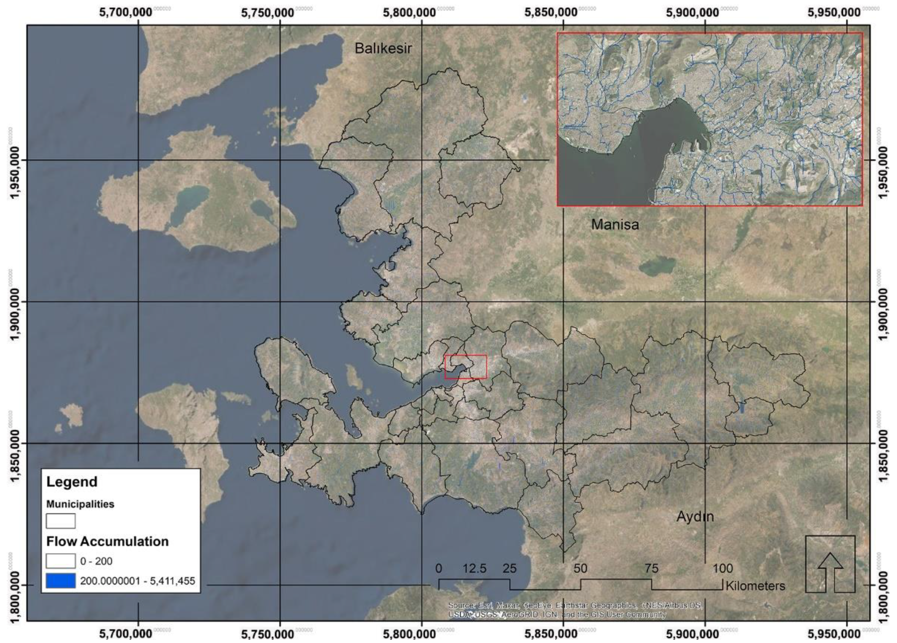
2.1. The Area of Interest
2.2. The Idiosyncratic Vulnerability of the City
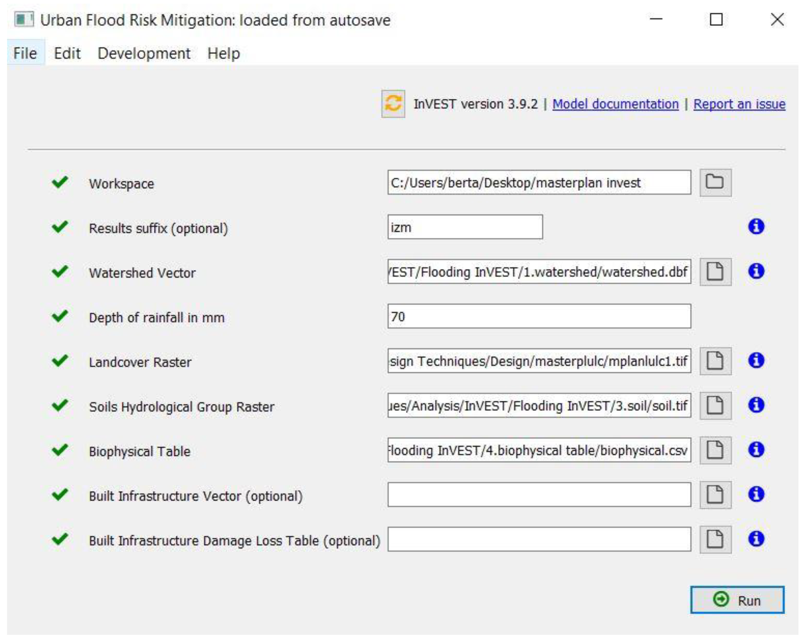
2.3. Modeling Urban Run-Off
- Watershed vector delineating areas of interest;
- Depth of rainfall in mm (of a single cloudburst event);
- Land use/land cover map (LULC);
- Soil hydrologic group raster;
- The biophysical value corresponds to each land-use class in the land cover map.
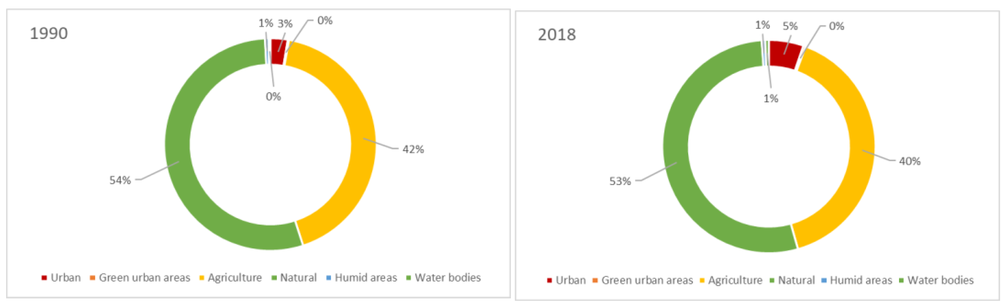
2.3.1. The Land Use/Land Cover Dataset
- From the continuous imperviousness value to a discrete classification of urban areas;
- Reclassification of the urban green areas, agricultural lands, and grasslands according to their imperviousness levels;
- From continuous forest value to a discrete reclassification in three classes: poor, fair and good;
- Utilization of the raster combine tool and final classification (see Figure 5).
2.3.2. The Soil Hydraulic Conductibility
3. Results
3.1. The Modeling Output
3.2. The Modeling Output
3.3. A Final Composite Hydrological Vulnerability Index
3.4. Measuring the Biophysical Benefits
4. Discussion
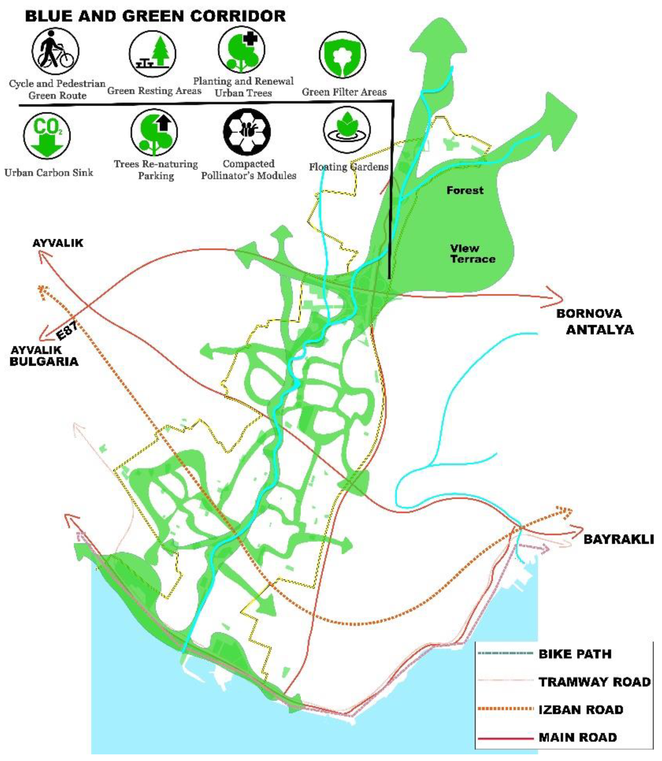
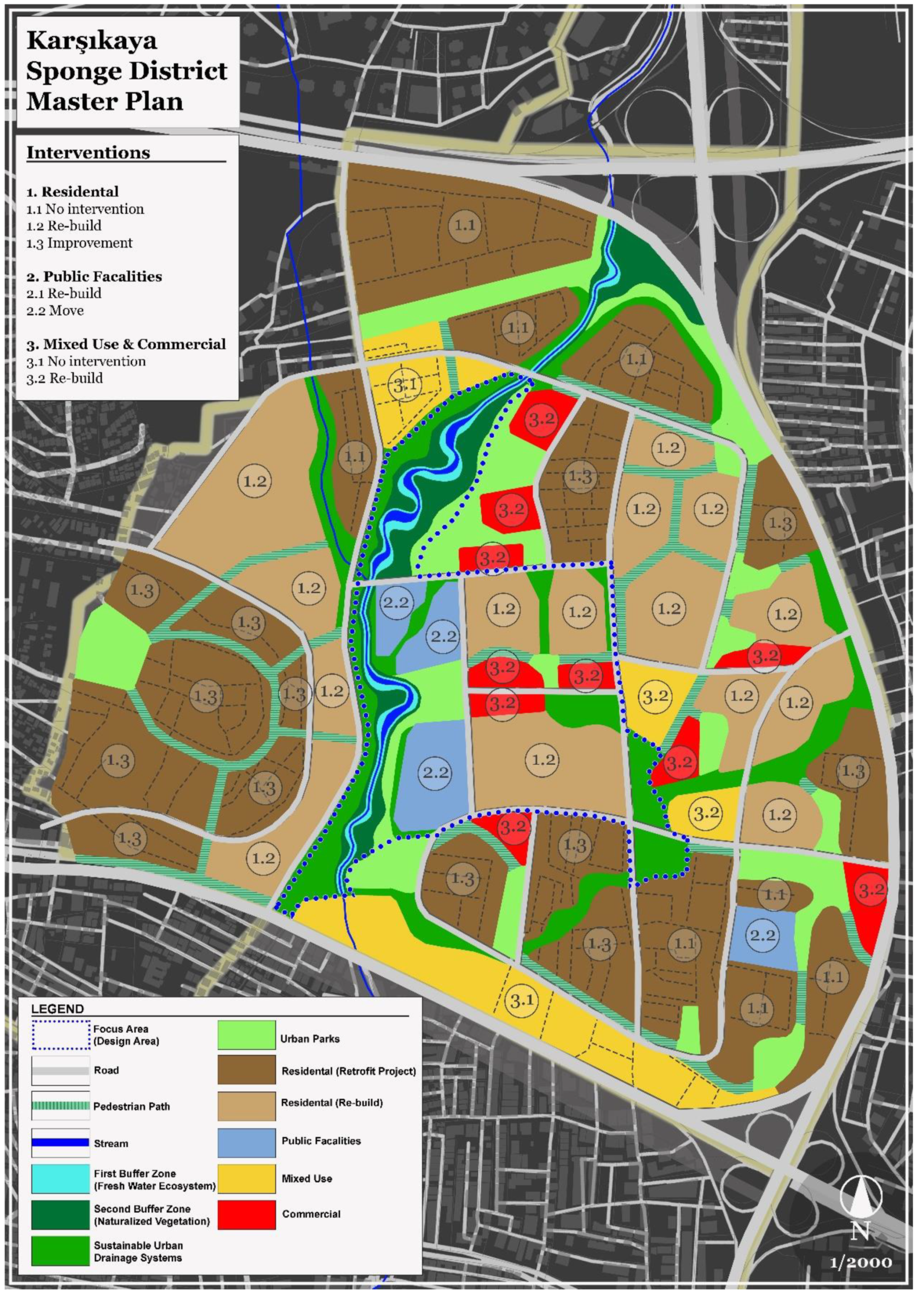
Designing the Sponge District Using Digital Models
5. Conclusions
Author Contributions
Funding
Acknowledgments
Conflicts of Interest
References
- Rosenzweig, B.; Ruddell, B.L.; McPhillips, L.; Hobbins, R.; McPhearson, T.; Cheng, Z.; Chang, H.; Kim, Y. Developing Knowledge Systems for Urban Resilience to Cloudburst Rain Events. Environ. Sci. Policy 2019, 99, 150–159. [Google Scholar] [CrossRef]
- Bernstein, L.; Bosch, P.; Canziani, O.; Chen, Z.; Christ, R.; Davidson, O.; Hare, W.; Huq, S.; Karoly, D.; Kattsov, V.; et al. Climate Change 2007: Synthesis Report. Contribution of Working Groups I, II and III to the Fourth Assessment Report of the Intergovernmental Panel on Climate Change; IPCC: Geneva, Switzerland, 2007. [Google Scholar]
- Copenhagen Municipality. City of Copenhagen Cloudburst Management Plan 2012; Copenhagen Municipality: Copenhagen, Denmark, 2012; pp. 1–28. [Google Scholar]
- Pelling, M.; Manuel-Navarrete, D. From Resilience to Transformation: The Adaptive Cycle in Two Mexican Urban Centers. Ecol. Soc. 2011, 16. Available online: https://www.ecologyandsociety.org/vol16/iss2/art11/ (accessed on 3 February 2022). [CrossRef] [Green Version]
- Chelleri, L. From the «Resilient City» to Urban Resilience. A Review Essay on Understanding and Integrating the Resilience Perspective for Urban Systems. Doc. D’anàlisi Geogràfica 2012, 582, 287–306. [Google Scholar] [CrossRef]
- Runhaar, H.; Wilk, B.; Persson, Å.; Uittenbroek, C.; Wamsler, C. Mainstreaming Climate Adaptation: Taking Stock about “What Works” from Empirical Research Worldwide. Reg. Environ. Chang. 2018, 18, 1201–1210. [Google Scholar] [CrossRef] [Green Version]
- Weichselgartner, J.; Kelman, I. Geographies of Resilience: Challenges and Opportunities of a Descriptive Concept. Prog. Hum. Geogr. 2015, 39, 249–267. [Google Scholar] [CrossRef] [Green Version]
- Ali, R.; Kuriqi, A.; Kisi, O. Human-Environment Natural Disasters Interconnection in China: A Review. Climate 2020, 8, 48. [Google Scholar] [CrossRef] [Green Version]
- Mitchell, J.K. Megacities and Natural Disasters: A Comparative Analysis. GeoJournal 1999, 49, 137–142. [Google Scholar] [CrossRef]
- Pappalardo, V.; La Rosa, D.; Campisano, A.; La Greca, P. The Potential of Green Infrastructure Application in Urban Runoff Control for Land Use Planning: A Preliminary Evaluation from a Southern Italy Case Study. Ecosyst. Serv. 2017, 26, 345–354. [Google Scholar] [CrossRef]
- Gill, S.E.; Handley, J.F.; Ennos, A.R.; Pauleit, S. Adapting Cities for Climate Change: The Role of the Green Infrastructure. Built Environ. 2007, 33, 115–133. [Google Scholar] [CrossRef] [Green Version]
- Chang, B.; Wherley, B.; Aitkenhead-Peterson, J.A.; McInnes, K.J. Effects of Urban Residential Landscape Composition on Surface Runoff Generation. Sci. Total Environ. 2021, 783, 146977. [Google Scholar] [CrossRef] [PubMed]
- Land Monitoring Service European Commission CORINE Land Cover. Available online: https://land.copernicus.eu/pan-european/corine-land-cover (accessed on 3 February 2022).
- Coskun Hepcan, C. Quantifying Landscape Pattern and Connectivity in a Mediterranean Coastal Settlement: The Case of the Urla District, Turkey. Environ. Monit. Assess. 2013, 185, 143–155. [Google Scholar] [CrossRef] [PubMed]
- Kesgin Atak, B.; Ersoy Tonyaloğlu, E. Monitoring the Spatiotemporal Changes in Regional Ecosystem Health: A Case Study in Izmir, Turkey. Environ. Monit. Assess. 2020, 192, 385. [Google Scholar] [CrossRef] [PubMed]
- Benini, L.; Bandini, V.; Marazza, D.; Contin, A. Assessment of Land Use Changes through an Indicator-Based Approach: A Case Study from the Lamone River Basin in Northern Italy. Ecol. Indic. 2010, 10, 4–14. [Google Scholar] [CrossRef]
- Salata, S.; Gardi, C. From Quantitative to Qualitative Analysis of Land-Take. The Application of a Composite Indicator for Targeted Policies of Land Take Reduction. CSE J. 2014, 1, 15–31. [Google Scholar] [CrossRef]
- TURKSTAT Turkish Statistical Institute. Address Based Population Registration System. Available online: https://www.tuik.gov.tr/ (accessed on 3 February 2022).
- Meerow, S.; Newell, J.P. Urban Resilience for Whom, What, When, Where, and Why? Urban Geogr. 2016, 40, 309–329. [Google Scholar] [CrossRef]
- Towfiqul Islam, A.R.M.; Talukdar, S.; Mahato, S.; Kundu, S.; Eibek, K.U.; Pham, Q.B.; Kuriqi, A.; Linh, N.T.T. Flood Susceptibility Modelling Using Advanced Ensemble Machine Learning Models. Geosci. Front. 2021, 12, 101075. [Google Scholar] [CrossRef]
- Salata, S. Land Take in the Italian Alps: Assessment and Proposals for Further Development. Manag. Environ. Qual. 2014, 25, 407–420. [Google Scholar] [CrossRef]
- Leal, M.; Fragoso, M.; Lopes, S.; Reis, E. Material damage caused by high-magnitude rainfall based on insurance data: Comparing two flooding events in the Lisbon Metropolitan Area and Madeira Island, Portugal. Int. J. Disaster Risk Reduct. 2020, 51. [Google Scholar] [CrossRef]
- Eraydin, A.; Tasan-Kok, T. Resilience Thinking in Urban Planning; Springer: Dordrecht, The Netherlands, 2013; ISBN 9789400754751. [Google Scholar]
- Özcan, E. Sel Olayı ve Türkiye Floods and Turkey; Gazi University Journal of Gazi Education Faculty: Ankara, Turkey, 2006; Volume 26. [Google Scholar]
- Schreurs, M.A. The Paris Climate Agreement and the Three Largest Emitters: China, the United States, and the European Union. Politics Gov. 2016, 4, 219–223. [Google Scholar] [CrossRef] [Green Version]
- IPCC. Climate Change 2022: Impacts, Adaptation, and Vulnerability. Contribution of Working Group II to the Sixth Assessment Report of the Intergovernmental Panel on Climate Change; Pörtner, H.-O., Roberts, D.C., Tignor, M., Poloczanska, E.S., Mintenbeck, K., Alegría, A., Craig, M., Langsdorf, S., Löschke, S., Möller, V., et al., Eds.; Cambridge University Press: Cambridge, UK, 2022; in press. [Google Scholar]
- Fuchs, S.; Keiler, M.; Ortlepp, R.; Schinke, R.; Papathoma-Köhle, M. Recent Advances in Vulnerability Assessment for the Built Environment Exposed to Torrential Hazards: Challenges and the Way Forward. J. Hydrol. 2019, 575, 587–595. [Google Scholar] [CrossRef]
- Rehan, B.M. Accounting Public and Individual Flood Protection Measures in Damage Assessment: A Novel Approach for Quantitative Assessment of Vulnerability and Flood Risk Associated with Local Engineering Adaptation Options. J. Hydrol. 2018, 563, 863–873. [Google Scholar] [CrossRef]
- Çağla, E. Assessing Adaptation Strategies against Flood Risk in Urban Coastal Areas through Izmir Karsıyaka Coastline Case. MEGARON/Yıldız Tech. Univ. Fac. Archit. E-J. 2022. [Google Scholar] [CrossRef]
- Langemeyer, J.; Gómez-Baggethun, E.; Haase, D.; Scheuer, S.; Elmqvist, T. Bridging the Gap between Ecosystem Service Assessments and Land-Use Planning through Multi-Criteria Decision Analysis (MCDA). Environ. Sci. Policy 2016, 62, 45–56. [Google Scholar] [CrossRef]
- Langemeyer, J.; Wedgwood, D.; McPhearson, T.; Baró, F.; Madsen, A.L.; Barton, D. Creating Nature-Based Solutions Where They Are Needed—A Spatial Ecosystem Service-Based Decision Analysis of Green Roofs in Barcelona. Sci. Total Environ. 2019, 707, 135487. [Google Scholar] [CrossRef]
- Yang, B.; Lee, D. Urban Green Space Arrangement for an Optimal Landscape Planning Strategy for Runoff Reduction. Land 2021, 10, 897. [Google Scholar] [CrossRef]
- Maragno, D.; Gaglio, M.; Robbi, M.; Appiotti, F.; Fano, E.A.; Gissi, E. Fine-Scale Analysis of Urban Flooding Reduction from Green Infrastructure: An Ecosystem Services Approach for the Management of Water Flows. Ecol. Model. 2018, 386, 1–10. [Google Scholar] [CrossRef]
- Tallis, H.T.; Ricketts, T.; Guerry, A.D.; Wood, S.A.; Sharp, R.; Nelson, E.; Ennaanay, D.; Wolny, S.; Olwero, N.; Vigerstol, K.; et al. InVEST 2.0 Beta User’s Guide; Stanford University: Stanford, CA, USA, 2011. [Google Scholar]
- Salata, S.; Ronchi, S.; Giaimo, C.; Arcidiacono, A.; Pantaloni, G.G. Performance-Based Planning to Reduce Flooding Vulnerability Insights from the Case of Turin (North-West Italy). Sustainability 2021, 13, 5697. [Google Scholar] [CrossRef]
- Arthur-Hartranft, S.T.; Carlson, T.N.; Clarke, K.C. Satellite and Ground-Based Microclimate and Hydrologic Analyses Coupled with a Regional Urban Growth Model. Remote Sens. Environ. 2003, 86, 385–400. [Google Scholar] [CrossRef]
- Terryn, E.; Boelens, L.; Pisman, A. Beyond the Divide: Evaluation in Co-Evolutionary Spatial Planning. Eur. Plan. Stud. 2016, 24, 1079–1097. [Google Scholar] [CrossRef]
- Brunetta, G.; Ceravolo, R.; Barbieri, C.A.; Borghini, A.; de Carlo, F.; Mela, A.; Beltramo, S.; Longhi, A.; De Lucia, G.; Ferraris, S.; et al. Territorial Resilience: Toward a Proactive Meaning for Spatial Planning. Sustainability 2019, 11, 2286. [Google Scholar] [CrossRef] [Green Version]
- Davoudi, S.; Crawford, J.; Mehmood, A. Planning for Climate Change: Strategies for Mitigation and Adaption for Spatial Planners; Routledge: London, UK, 2009; ISBN 9781844076628. [Google Scholar]
- Davoudi, S.; Brooks, E.; Mehmood, A. Evolutionary Resilience and Strategies for Climate Adaptation. Plan. Pract. Res. 2013, 28, 307–322. [Google Scholar] [CrossRef] [Green Version]
- Maragno, D.; Dall’omo, C.F.; Pozzer, G.; Musco, F. Multi-Risk Climate Mapping for the Adaptation of the Venice Metropolitan Area. Sustainability 2021, 13, 1334. [Google Scholar] [CrossRef]
- Albert, C.; Galler, C.; Hermes, J.; Neuendorf, F.; Von Haaren, C.; Lovett, A. Applying Ecosystem Services Indicators in Landscape Planning and Management: The ES-in-Planning Framework. Ecol. Indic. 2016, 61, 100–113. [Google Scholar] [CrossRef]
- Salata, S. Ecologically-Compatible urban Planning. Designing a Healthier Environment; Emerald Publishing Limited: Bingley, UK, 2019; ISBN 9781789737844. [Google Scholar]
- Brunetta, G.; Salata, S. Mapping Urban Resilience for Spatial Planning—A First Attempt to Measure the Vulnerability of the System. Sustainability 2019, 11, 2331. [Google Scholar] [CrossRef] [Green Version]
- Velibeyoğlu, K.; Özdemir, S.; Baba, A.; Arsan, Z.D.; Yazdani, H.; Hazar, D.; Kaplan, A.; Boyacı, M.; Kurucu, Y.; Erdoğan, N.; et al. ‘Urla-Çeşme-Karaburun’ Peninsula Sustainable Development Strategy 2014–2023; İZKA (İzmir Development Agency): Izmir, Turkey, 2014. [Google Scholar]
- Matthews, H. Greco-Romans Cities of Aegean Turkey. History, Archaeology, Architecture; Ege Yayinlari: Istanbul, Turkey, 2014. [Google Scholar]
- Velibeyoglu, K. Regional Acupuncture for Izmir Peninsula: Creating Capital Web for Creative Eco-Tourism. J. Environ. Prot. Ecol. 2016, 17, 666–674. [Google Scholar]
- Saricam, S.Y.; Erdem, U. Planning of Izmir-Karaburun Peninsula as Biosphere Reserve Area. Ekoloji 2010, 19, 42–50. [Google Scholar] [CrossRef]
- Kurucu, Y.; Chiristina, N. Monitoring the Impacts of Urbanization and Industrialization on the Agricultural Land and Environment of the Torbali, Izmir Region, Turkey. Environ. Monit. Assess. 2008, 136, 289–297. [Google Scholar] [CrossRef] [PubMed]
- Ozdemir, C.; Şahinkaya, S.; Kalıpcı, E.; Oden, M.K.; Nurlu, E.; Erdem, Ü.; Doygun, H.; Oğuz, H.; Kesgin, B.; Doygun, N.; et al. The Effects of Land Cover Change on Natural Ecosystems: The Case of İzmir, Turkey Digital Proceeding Of THE ICOEST’2013-, Cappadocia The Effects of Land Cover Change on Natural Ecosystems: The Case of İzmir, Turkey; Selcuk University: Konya, Turkey, 2013. [Google Scholar]
- Duarte, G.T.; Ribeiro, M.C.; Paglia, A.P.; Csuti, B.; Fackler, P.; Lonsdorf, E. Ecosystem Services Modeling as a Tool for Defining Priority Areas for Conservation. PLoS ONE 2016, 11, e0154573. [Google Scholar] [CrossRef] [PubMed] [Green Version]
- Maes, J.; Liquete, C.; Teller, A.; Erhard, M.; Paracchini, M.L.; Barredo, J.I.; Grizzetti, B.; Cardoso, A.; Somma, F.; Petersen, J.E.; et al. An Indicator Framework for Assessing Ecosystem Services in Support of the EU Biodiversity Strategy to 2020. Ecosyst. Serv. 2016, 17, 14–23. [Google Scholar] [CrossRef] [Green Version]
- Gómez-Baggethun, E.; Barton, D.N. Classifying and Valuing Ecosystem Services for Urban Planning. Ecol. Econ. 2012, 86, 235–245. [Google Scholar] [CrossRef]
- Morabito, M.; Crisci, A.; Georgiadis, T.; Orlandini, S.; Munafò, M.; Congedo, L.; Rota, P.; Zazzi, M. Urban Imperviousness Effects on Summer Surface Temperatures Nearby Residential Buildings in Different Urban Zones of Parma. Remote Sens. 2018, 10, 26. [Google Scholar] [CrossRef] [Green Version]
- Diakakis, M.; Deligiannakis, G.; Pallikarakis, A.; Skordoulis, M. Factors Controlling the Spatial Distribution of Flash Flooding in the Complex Environment of a Metropolitan Urban Area. The Case of Athens 2013 Flash Flood Event. Int. J. Disaster Risk Reduct. 2016, 18, 171–180. [Google Scholar] [CrossRef]
- Artmann, M. Urban Gray vs. Urban Green vs. Soil Protection—Development of a Systemic Solution to Soil Sealing Management on the Example of Germany. Environ. Impact Assess. Rev. 2016, 59, 27–42. [Google Scholar] [CrossRef]
- Lamandé, M.; Greve, M.H.; Schjønning, P. Risk Assessment of Soil Compaction in Europe—Rubber Tracks or Wheels on Machinery. Catena 2018, 167, 353–362. [Google Scholar] [CrossRef]
- Glæsner, N.; Helming, K.; de Vries, W. Do Current European Policies Prevent Soil Threats and Support Soil Functions. Sustainability 2014, 6, 9538–9563. [Google Scholar] [CrossRef] [Green Version]
- United Nations. Convention to Combat Desertification in Those Countries Experiencing Serious Drought and/or Desertification, Particularly in Africa; United Nations: Paris, France, 1994; Volume 1954. [Google Scholar]
- Ronchi, S.; Salata, S.; Arcidiacono, A.; Piroli, E.; Montanarella, L. Policy Instruments for Soil Protection among the EU Member States: A Comparative Analysis. Land Use Policy 2019, 82, 763–780. [Google Scholar] [CrossRef]
- Prăvălie, R.; Patriche, C.; Bandoc, G. Quantification of Land Degradation Sensitivity Areas in Southern and Central Southeastern Europe. New Results Based on Improving DISMED Methodology with New Climate Data. Catena 2017, 158, 309–320. [Google Scholar] [CrossRef]
- European Commission. Guidelines on Best Practice to Limit, Mitigate or Compensate Soil Sealing; European Union: Brussels, Belgium, 2012; ISBN 9789279262104. [Google Scholar]
- European Commission. Future Brief: No Net Land Take by 2050? European Union: Bristol, UK, 2016. [Google Scholar]
- Giridharan, R.; Emmanuel, R. The Impact of Urban Compactness, Comfort Strategies and Energy Consumption on Tropical Urban Heat Island Intensity: A Review. Sustain. Cities Soc. 2018, 40, 677–687. [Google Scholar] [CrossRef] [Green Version]
- Jiao, L. Urban Land Density Function: A New Method to Characterize Urban Expansion. Landsc. Urban Plan. 2015, 139, 26–39. [Google Scholar] [CrossRef]
- Mubareka, S.; Koomen, E.; Estreguil, C.; Lavalle, C. Development of a Composite Index of Urban Compactness for Land Use Modelling Applications. Landsc. Urban Plan. 2011, 103, 303–317. [Google Scholar] [CrossRef]
- Chelleri, L.; Waters, J.J.; Olazabal, M.; Minucci, G. Resilience Trade-Offs: Addressing Multiple Scales and Temporal Aspects of Urban Resilience. Environ. Urban. 2015, 27, 181–198. [Google Scholar] [CrossRef] [Green Version]
- Pistocchi, A.; Calzolari, C.; Malucelli, F.; Ungaro, F. Soil Sealing and Flood Risks in the Plains of Emilia-Romagna, Italy. J. Hydrol. Reg. Stud. 2015, 4, 398–409. [Google Scholar] [CrossRef]
- Davis, M.; Naumann, S. Making the Case for Sustainable Urban Drainage Systems as a Nature-Based Solution to Urban Flooding. In Theory and Practice of Urban Sustainability Transitions; Springer: Cham, Switzerland, 2017; pp. 123–137. [Google Scholar]
- Xu, C.; Rahman, M.; Haase, D.; Wu, Y.; Su, M.; Pauleit, S. Surface Runoff in Urban Areas: The Role of Residential Cover and Urban Growth Form. J. Clean. Prod. 2020, 262, 121421. [Google Scholar] [CrossRef]
- USDA. Module 104: Runoff Curve Number Computations. Study Guide; United States Department of Agriculture Hydrology Training Series; Natural Resources Conservation Service: Washington, DC, USA, 1989. Available online: https://www.nrcs.usda.gov/Internet/FSE_DOCUMENTS/stelprdb1082992.pdf (accessed on 3 February 2022).
- Buchhorn, M.; Lesiv, M.; Tsendbazar, N.-E.; Herold, M.; Bertels, L.; Smets, B. Copernicus Global Land Cover Layers—Collection 2. Remote Sens. 2020, 12, 1044. [Google Scholar] [CrossRef] [Green Version]
- Muñoz-Carpena, R.; Zajac, Z.; Kuo, Y. Global Sensitivity and Uncertainty Analyses of the Water Quality Model VFSMOD-W. Trans. Asabe 2007, 50, 1719–1732. [Google Scholar] [CrossRef] [Green Version]
- Ross, C.W.; Prihodko, L.; Anchang, J.; Kumar, S.; Ji, W.; Hanan, N.P. HYSOGs250m, Global Gridded Hydrologic Soil Groups for Curve-Number-Based Runoff Modeling. Sci. Data 2018, 5, 180091. [Google Scholar] [CrossRef] [PubMed]
- Salata, S.; Giaimo, C.; Barbieri, C.A.; Ballocca, A.; Scalise, F.; Pantaloni, G. The Utilization of Normalized Difference Vegetation Index to Map Habitat Quality in Turin (Italy). Sustainability 2020, 12, 7751. [Google Scholar] [CrossRef]
- Grêt-Regamey, A.; Altwegg, J.; Sirén, E.A.; van Strien, M.J.; Weibel, B. Integrating Ecosystem Services into Spatial Planning—A Spatial Decision Support Tool. Landsc. Urban Plan. 2017, 165, 206–219. [Google Scholar] [CrossRef] [Green Version]
- McPhearson, T.; Andersson, E.; Elmqvist, T.; Frantzeskaki, N. Resilience of and through Urban Ecosystem Services. Ecosyst. Serv. 2015, 12, 152–156. [Google Scholar] [CrossRef]
- Beven, K. The SuDS Manual; CIRIA: London, UK, 2012; ISBN 9780860177609. [Google Scholar]


| CODE | LABEL Corine Land Cover | Imperviousness (Mean) (%) | Standard Deviation |
|---|---|---|---|
| 11 | Continuous urban fabric | 75.09 | 33.06 |
| 112 | Discontinuous urban fabric | 34.27 | 37.83 |
| 121 | Industrial or commercial units | 44.38 | 45.40 |
| 122 | Road and rail networks and associated land | 21.82 | 34.94 |
| 123 | Port areas | 50.08 | 47.26 |
| 124 | Airports | 15.70 | 33.51 |
| 131 | Mineral extraction sites | 3.71 | 17.75 |
| 132 | Dumpsites | 10.92 | 29.23 |
| 133 | Construction sites | 7.17 | 23.11 |
| 141 | Green urban areas | 2.74 | 13.86 |
| 142 | Sport and leisure facilities | 14.19 | 25.88 |
| 211 | Non-irrigated arable land | 0.73 | 7.42 |
| 212 | Permanently irrigated land | 0.61 | 6.94 |
| 221 | Vineyards | 0.39 | 5.34 |
| 222 | Fruit trees and berry plantations | 0.80 | 7.85 |
| 223 | Olive groves | 0.44 | 5.69 |
| 231 | Pastures | 0.55 | 6.48 |
| 242 | Complex cultivation patterns | 1.50 | 10.33 |
| 243 | Agriculture with natural vegetation | 0.26 | 4.17 |
| 311 | Broad-leaved forest | 0.01 | 0.95 |
| 312 | Coniferous forest | 0.05 | 1.88 |
| 313 | Mixed forest | 0.03 | 1.46 |
| 321 | Natural grasslands | 0.26 | 4.44 |
| 323 | Sclerophyllous vegetation | 0.19 | 3.72 |
| 324 | Transitional woodland-shrub | 0.13 | 3.16 |
| 331 | Beaches, dunes, sands | 1.30 | 10.45 |
| 332 | Bare rocks | 0.21 | 4.49 |
| 333 | Sparsely vegetated areas | 0.20 | 4.07 |
| 411 | Inland marshes | 0.04 | 1.42 |
| 421 | Salt marshes | 0.09 | 2.34 |
| 422 | Saline | 0.24 | 4.54 |
| 511 | Watercourses | - | - |
| 512 | Water bodies | 0.08 | 2.64 |
| 521 | Coastal lagoons | - | - |
| 522 | Estuaries | - | - |
| 523 | Sea and ocean | 0.97 | 9.17 |
| Cover Description | Curve Numbers for Hydrologic Soil Group | LUCODE | ||||
|---|---|---|---|---|---|---|
| A | B | C | D | |||
| Open space (lawns, parks, golf courses, cemeteries, etc.) | Poor condition (grass cover < 50%) | 68 | 79 | 86 | 89 | 10 |
| Good condition (grass cover > 75%) | 39 | 61 | 74 | 80 | 11 | |
| Impervious areas | Paved parking lots, roofs, driveways, etc. (excluding right of way) | 98 | 98 | 98 | 98 | 9 |
| Urban districts | Commercial and business (85% imp.) | 89 | 92 | 94 | 95 | 8 |
| Industrial (72% imp.) | 81 | 88 | 91 | 93 | 7 | |
| Residential districts by average lot size | 1⁄8 acre or less (town houses) (65% imp.) | 77 | 85 | 90 | 92 | 6 |
| 1⁄4 acre (38% imp.) | 61 | 75 | 83 | 87 | 5 | |
| 1⁄3 acre (30% imp.) | 57 | 72 | 81 | 86 | 4 | |
| 1⁄2 acre (25% imp.) | 54 | 70 | 80 | 85 | 3 | |
| 1 acre (20% imp.) | 51 | 68 | 79 | 84 | 2 | |
| 2 acres (12% imp.) | 46 | 65 | 77 | 82 | 1 | |
| Row crops | Straight row (SR) | Poor | 72 | 81 | 88 | 12 |
| Pasture, grassland, or range—continuous forage for grazing. A | Fair | 49 | 69 | 79 | 84 | 13 |
| Woods. no | Poor | 45 | 66 | 77 | 83 | 14 |
| Fair | 36 | 60 | 73 | 79 | 15 | |
| Good | 30 | 55 | 70 | 77 | 16 | |
| Group A | Group B | Group C | Group D | |
|---|---|---|---|---|
| Saturated hydraulic conductivity of the least transmissive (soil depth 50 and 100 cm) | >40 m/s | [40;10] m/s | [10;1] m/s | <1 m/s |
| Geological Units | Hydrological Soil Groups |
|---|---|
| Clastic rocks | A |
| Lime soil | A |
| Sediment soil | A |
| Terrestrial clastic units | B |
| Terrestrial clastic units | B |
| Lacustrine limestone, marn, shale | D |
| Andesite, rhyolite, basalt, dacite | C |
| Pyroclastic units | D |
| Granitoid | D |
| Oligocene volcanic units | C |
| Volcano-sedimentary units | C |
| Flysch | D |
| Nautical limestone | B |
| Ophiolite-serpentinite-basalt | D |
| Marble, limestone | B |
| Neritic limestone | B |
| Carbonate, metamorphic and clastic units | B |
| Granitoid | D |
| Clastic and carbonate sedimentary units | B |
| Schist, quartzite, quartz-schist, phyllite | B |
| Carbonate and clastic units | C |
| Schist, marble, quartzite, quartz-schist, phyllite | D |
| Gneissoid, schist, migmatite | D |
| Meta-granitoid | D |
| Municipality | Run-Off Retention Index | Run-Off Retention (m3) | Flood Volume (m3) |
|---|---|---|---|
| Aliağa | 0.70 | 17,173,508.23 | 7,445,036.76 |
| Balçova | 0.63 | 920,932.20 | 539,120.95 |
| Bayındır | 0.81 | 32,146,939.00 | 7,504,043.92 |
| Bayraklı | 0.49 | 1,186,410.48 | 1,243,233.71 |
| Bergama | 0.73 | 79,583,587.02 | 29,190,154.92 |
| Beydağ | 0.68 | 8,032,429.95 | 3,693,976.89 |
| Bornova | 0.66 | 10,836,740.28 | 5,570,777.46 |
| Buca | 0.70 | 10,194,175.78 | 4,420,977.82 |
| Çeşme | 0.65 | 12,096,405.84 | 6,460,727.57 |
| Çiğli | 0.75 | 7,034,433.31 | 2,395,672.43 |
| Dikili | 0.73 | 2,5816,567.86 | 9,527,504.64 |
| Foça | 0.68 | 10,748,412.06 | 5,094,393.57 |
| Gaziemir | 0.63 | 2,748,811.78 | 1,644,017.36 |
| Güzelbahçe | 0.76 | 4,474,773.62 | 1,397,883.67 |
| Karabağlar | 0.64 | 4,475,143.90 | 2,563,685.84 |
| Karaburun | 0.77 | 21,247,082.42 | 6,335,984.49 |
| Karşıyaka | 0.58 | 2,057,939.97 | 1,510,016.29 |
| Kemalpaşa | 0.84 | 38,472,376.20 | 7,244,207.49 |
| Kınık | 0.79 | 27,883,205.59 | 7,207,772.85 |
| Kiraz | 0.67 | 25,887,204.19 | 12,589,072.30 |
| Konak | 0.28 | 460,533.59 | 1,201,959.60 |
| Menderes | 0.79 | 43,733,870.88 | 11,767,459.95 |
| Menemen | 0.76 | 30,891,183.57 | 9,712,214.58 |
| Narlıdere | 0.76 | 2,420,437.15 | 751,970.18 |
| Ödemiş | 0.75 | 53,831,011.16 | 17,482,136.18 |
| Seferihisar | 0.75 | 20,012,923.72 | 6,783,987.76 |
| Selçuk | 0.81 | 19,723,677.33 | 4,580,217.88 |
| Tire | 0.76 | 41,076,490.26 | 12,727,152.97 |
| Torbalı | 0.80 | 31,240,248.61 | 8,050,377.81 |
| Urla | 0.78 | 36,038,690.17 | 10,438,909.74 |
| Land Use | Vulnerability (Average) | Average District Size | Imperviousness (Average) | Forest (Average) | Pop/ha |
|---|---|---|---|---|---|
| Airports | 0.20 | 1,022,491.82 | 30.09 | 2.58 | - |
| Arable land (annual crops) | 0.16 | 312,838.00 | 2.51 | 10.16 | 2.01 |
| Complex and mixed cultivation patterns | 0.25 | 93,845.99 | 1.06 | 20.22 | - |
| Construction sites | 0.33 | 35,815.19 | 20.76 | 0.82 | - |
| Continuous urban fabric (S.L.: >80%) | 0.78 | 4244.60 | 89.29 | 0.37 | 350.79 |
| Discontinuous dense urban fabric (S.L.: 50–80%) | 0.56 | 8846.49 | 61.42 | 3.08 | 211.05 |
| Discontinuous low-density urban fabric (S.L.: 10–30%) | 0.29 | 13,878.40 | 25.00 | 6.51 | 60.20 |
| Discontinuous medium density urban fabric (S.L.: 30–50%) | 0.39 | 12,887.26 | 40.88 | 5.40 | 98.06 |
| Discontinuous very-low-density urban fabric (S.L.: <10%) | 0.22 | 10,004.88 | 9.83 | 8.21 | 30.15 |
| Fast transit roads and associated land | 0.36 | 181,461.71 | 34.48 | 1.43 | - |
| Forests | 0.21 | 342,492.43 | 0.16 | 56.22 | - |
| Green urban areas | 0.32 | 14,102.58 | 20.66 | 19.10 | - |
| Herbaceous vegetation associations (natural grassland, moors, etc.) | 0.26 | 311,558.56 | 2.24 | 29.78 | - |
| Industrial, commercial, public, military, and private units | 0.40 | 21,761.79 | 43.44 | 3.32 | 28.88 |
| Isolated structures | 0.15 | 4728.27 | 2.28 | 14.89 | 48.16 |
| Land without current use | 0.37 | 10,960.48 | 28.06 | 4.50 | - |
| Mineral extraction and dump sites | 0.31 | 52,556.34 | 11.15 | 2.20 | - |
| Open spaces with little or no vegetation (beaches, dunes, bare rocks, glaciers) | 0.20 | 64,715.20 | 2.04 | 6.25 | - |
| Other roads and associated land | 0.40 | 262,561.67 | 16.67 | 10.23 | - |
| Pastures | 0.23 | 67,119.48 | 1.51 | 10.59 | 3.85 |
| Permanent crops (vineyards, fruit trees, olive groves) | 0.17 | 144,370.54 | 1.02 | 22.53 | 1.85 |
| Port areas | 0.47 | 11,270.88 | 48.10 | 3.12 | 681.99 |
| Railways and associated land | 0.37 | 63,622.48 | 40.75 | 2.95 | - |
| Sports and leisure facilities | 0.35 | 25,422.58 | 29.90 | 9.14 | 14.15 |
| Water | 0.18 | 238,742.25 | 9.65 | 9.47 | - |
| Wetlands | 0.12 | 449,345.63 | 1.78 | 10.46 | - |
| Time | Run-Off Retention Index | Run-Off Retention Volume (m3) | Flood Volume (m3) | Run-Off Retention Volume (m3) |
|---|---|---|---|---|
| Present | 0.38 | 265,623.49 | 298,282.55 | 265,623.49 |
| Future | 0.60 | 323,006.89 | 240,941.14 | 323,006.89 |
| Interventions | Nature-Based Solution Implementations | Residential Areas | Public Facilities | Mixed and Commercial Areas | Urban Green System | |||||||
|---|---|---|---|---|---|---|---|---|---|---|---|---|
| 1.1 | 1.2 | 1.3 | 2.1 | 2.2 | 3.1 | 3.2 | 4.1 | 4.2 | 4.3 | 4.4 | ||
| No intervention | The current state of these areas with good construction status will be preserved. | X | X | X | ||||||||
| Re-build | Buildings in poor condition will be demolished and rebuilt according to new construction conditions. | X | ||||||||||
| A green facade will be applied in buildings with four floors or more. | X | X | ||||||||||
| Green roof applications will be made in buildings with less than four floors. | X | |||||||||||
| Green pedestrian circulation compatible with water movements will be constructed inside the building blocks. | X | |||||||||||
| Rainwater collection tanks will be located under the structures with a floor area of 200 m2 and above. | X | |||||||||||
| With the slope of the road, the water will be filtered and directed to the storage areas. | X | |||||||||||
| Improvement | The buildings and their surroundings will be changed from gray to green with retrofit projects. | X | ||||||||||
| Move | Relocalization of public services. | X | ||||||||||
| The same capacity and nature-friendly construction will be provided at the new location. | X | |||||||||||
| Walking Path | Seasonal channels in the form of walkways to direct the water will be placed. | X | ||||||||||
| Recreational Facilities | Pop-up gardens, parks, pavilions, amphitheater, pounds, and recreational uses, etc., that do not put pressure on nature will be created. | X | ||||||||||
| Active Green | Green areas, which are strengthened with sustainable urban drainage systems, will be designed for the use of urban residents integrated with nature. | X | ||||||||||
| Passive Green | Green areas without active use will be designed to help regulate the carbon cycle and drain water. | X | ||||||||||
Publisher’s Note: MDPI stays neutral with regard to jurisdictional claims in published maps and institutional affiliations. |
© 2022 by the authors. Licensee MDPI, Basel, Switzerland. This article is an open access article distributed under the terms and conditions of the Creative Commons Attribution (CC BY) license (https://creativecommons.org/licenses/by/4.0/).
Share and Cite
Salata, S.; Arslan, B. Designing with Ecosystem Modelling: The Sponge District Application in İzmir, Turkey. Sustainability 2022, 14, 3420. https://doi.org/10.3390/su14063420
Salata S, Arslan B. Designing with Ecosystem Modelling: The Sponge District Application in İzmir, Turkey. Sustainability. 2022; 14(6):3420. https://doi.org/10.3390/su14063420
Chicago/Turabian StyleSalata, Stefano, and Bertan Arslan. 2022. "Designing with Ecosystem Modelling: The Sponge District Application in İzmir, Turkey" Sustainability 14, no. 6: 3420. https://doi.org/10.3390/su14063420