Article

Education on Sustainable Development Goals: Geographical Perspectives for Gender Equality in Sustainable Cities and Communities

by
Rafael de Miguel González
and
María Sebastián-López
*
Faculty of Education, ARGOS-IUCA, University of Zaragoza, 50009 Zaragoza, Spain
*
Author to whom correspondence should be addressed.
Sustainability 2022, 14(7), 4042; https://doi.org/10.3390/su14074042
Submission received: 28 November 2021 / Revised: 26 March 2022 / Accepted: 28 March 2022 / Published: 29 March 2022
(This article belongs to the Special Issue Geographical Education for Sustainable Development)

Abstract

:
Because of its interdisciplinary approach as a social science directly related to the natural sciences, geography is the academic discipline and school subject that equips students well with knowledge, skills, and values related to education on sustainable development goals. This study is part of the results of MyGEO, a project funded by the European Commission, and it is based on a collaborative mapping of streets named after women in a medium-sized city (Zaragoza, Spain), in connection with the international initiative GeoChicas (GeoGirls) on OpenStreetMap. Its main objective is to obtain evidence to emphasize, through public and digital space, gender equality and the empowerment of women in teacher education by means of their achievements. The learning methodology consists of (i) standardization and correction of alphanumeric information referring to street names contained in the OpenStreetMap spatial database that identify gender and (ii) linking and creating thematic information through Wikipedia editing. The results show that Zaragoza is at the top of the ranking of Spanish and Latin American cities mapped to date in the “Women’s Streets” viewer, with 18% of the streets named after women, compared to the average 15% in the rest of the 30 cities involved in GeoChicas. The direct participation of trainee primary and secondary schoolteachers in this project makes it possible to consolidate a narrative as well as a specific instructional design on education for sustainable development, particularly on SDG number 5 (gender balance) and SDG number 11 (sustainable cities and communities).

1. Introduction

Geography is usually known as a school subject and field in the sciences that studies the Earth’s surface and the spaces and places where relationships between people and the environment happen. Geography explores the interactions between the physical environment and human societies, which produce landscapes, distributions, impacts, and spatial patterns from the local and regional to the national and global scale. Geography is the science of “where” and guides the inquiry process to acquire knowledge about how and why place, space, and environment matter. Geography contributes to raising awareness about the human and cultural diversity on the Earth. Geography studies not only locations but also how these locations develop and change over time. Geography is a scientific discipline that deals with the processes of spatial organization of human societies. Thus, geography is the academic discipline and school subject that equips students well with knowledge, skills, and values related to education on sustainable development goals.
First, geography is the most interdisciplinary discipline in school, allowing students to acquire physical and social environment vocabulary, process meaningful statistics, implement scientific methods, acquire personal and social (territorial) identity and citizenship, develop cultural awareness from natural and human landscapes, etc. Consequently, geography is an appropriate subject to promote sustainable development (goals) education from multiple perspectives (economic, social, and environmental) [1] as all the sustainable development goals are rooted in a branch of geography. This is because geography is a spatial science encompassing both social sciences (human geography) and natural sciences (physical geography); it can be linked to all the SDGs, as formulated in Table 1.
Secondly, geography is probably the subject where the technologies (in particular geospatial technologies, GIS, digital atlases, remote sensing, geolocation-based mobile apps, etc.) have had a greater impact on innovative learning and educational benefits: instructional resources, pedagogies, inquiry, problem-based learning, etc. [2].
Geography is an essential contribution to the achievement of the United Nations Agenda 2030 and Sustainable Development Goals (SDGs), as indicated by several recent studies [3,4,5,6,7,8]. Due to the transversal approach of the SDGs, geography is the most important school subject for education on sustainable development goals [9,10], as can be seen in the examples of good practices in European geographic education [11,12,13,14,15].
Sustainable development goals express a spatial concern about the main challenges facing the world today: ecological, economic, social, and political. Geography is the science of place (of where). Physical geography has traditionally been devoted to research into the biosphere and hydrosphere. Human geography studies where people live and how different societies (geographically and politically) develop productive activities, as well as their impact on the environment. In this way, each of the apparently novel sustainable development goals is intellectually indebted to the different fields of study of geography, scientifically consolidated over decades, as shown in Table 1.

2. Literature Review

2.1. Geography Education for Sustainable Development: Teacher Education Challenges

Education for sustainable development is the responsibility of many educational and social agents, although there is a broad consensus that universities [16] play a fundamental role as institutions training qualified professionals; building the capacity of new generations; and mobilizing young people who, once in the workplace, can multiply the effects of their actions and decisions to contribute to the achievement of the SDGs. In addition to educational function, universities have a critical role in delivering SDGs because of the capabilities in research, governance, and particularly external leadership and public engagement. To address SDG education, raise awareness, and implement, university members are well equipped to the transformative learning carried out in higher education activities: interdisciplinary knowledge, action-based learning, and multi-actor involvement (government, civil society, and private sector).
Educational disciplines, both in compulsory and higher education, require specific professional knowledge and skills, including understanding how the SDGs and global sustainable development challenges are relevant to one profession, sector, or activity. This means specialized knowledge and skills that will help the learners advance the SDGs through this profession. Examples include management, engineering, public policy, research, health, information, and communication technology, in addition to teaching in the primary and secondary education sector. This is also expressly stated and highlighted by SDG target 4.7, “ensure that all learners acquire the knowledge and skills needed to promote sustainable development, including, among others, through education for sustainable development” and by indicator 4.7.1.c, “Extent to which education for sustainable development, are mainstreamed at all levels in teacher education” [17].
Consequently, in Spanish universities, teacher training is a key factor in providing education on sustainability and sustainable development goals. However, what are the perceptions, knowledge, and skills of future teachers regarding SDGs before and after training? Research on the progress of students in teacher education programs on SDG knowledge and skills, as well as on pedagogies integrating SDGs into their teaching practice (or internship), shows that progress and improvement in their training with respect to the role of sustainability in education have been observed in three dimensions of analysis: education for sustainability, SDGs, and the methodological strategies for their integration [18]. In Spanish universities, four cross-curricular skills for sustainability have been agreed on for implementation in higher education, later tracked in research projects describing a rubric for the assessment of competencies of sustainability for teacher education degrees [18,19]. This rubric is based in the simplified pyramid of Miller and enables evaluation of new teachers on three dimensions: what they know about sustainability, if they are able to promote sustainability and how, and if they are able to develop educational strategies that promote sustainability in their students.
However, not all teachers have the same content on SDGs in their respective school curricula, and so not all of them have the same opportunities to teach sustainability. Teachers of natural and social sciences, and especially geography teachers, have a great responsibility for educating on the SDGs because of the interdisciplinary nature of knowledge, as mentioned above. Teaching and learning methods for promoting sustainability via geography have not been thoroughly studied, despite the proclamation by the International Geographical Union, in 2007, of the Lucerne Declaration on Geographical Education for Sustainable Development [20]. A recent qualitative study [21,22] has examined publications on geographical education for sustainable development and has drawn attention to some essentials, such as geographical and interdisciplinary competencies, learning topics, teaching and learning methods, and fieldwork and outdoor learning [23].
Two important aspects must also be taken into consideration for the conceptualization, development, implementation, and assessment of geographical education on sustainable development: curriculum and geospatial technologies. Defining a theoretical framework for geographical education on sustainable development [24] involves five phases: learning the directions and benefits of education on sustainability, educating the educators, identifying the pedagogies, taking action, and providing practical geographical education on sustainable development. Geospatial technology has proven to be the most effective tool for teaching and learning school geography in recent years, due to the wide availability of spatial data and the implementation of the technological, pedagogical, and content knowledge (TPACK) [25,26], as published in [2,27,28,29,30], even for geographical education on concrete sustainable development goals [12,23,31,32,33,34,35].

2.2. Role of GIS in Supporting ESD: The Importance of Implementing SDGs 11 and 5 in Education

The workshop held at the University of Zaragoza is related to the importance of neo-geography in the current social context, meaning the reinvention of the geographic science and the normalization of methods, techniques, and tools for non-expert users [36]. GIS offers society the possibility to create new spatial information of their environment. This has been made possible due to the simplicity of the skills involved in current collaborative mapping: mainly the use of Global Positioning System (GPS) devices and simple observation to collect information. Such initiatives have increased recently due to the COVID-19 pandemic, which has accelerated the overall process of digitalization and, thereby, digital collaborative mapping. In the current context, individuals no longer need to go out and do field work to be involved with their community. Volunteers can now participate in the causes they believe in from the comfort of their home, school, or working environment through an Internet-connected device. This particular type of volunteering, known as active citizen-sensor data, has skyrocketed in the past few years as technology has become ubiquitous (mobile devices, affordable sensors, web platforms, etc.), and even more so during the lockdowns and stay-at-home orders to curb the COVID-19 crisis [36].
Geographers are not the only ones using digital volunteering and citizen science. Many fields are taking advantage of this. Several disciplines have directly benefited from citizen contributions, particularly researchers of earth sciences and other sciences related to sustainable development, such as biology [37,38] and astronomy (Planet Hunters project). Disciplines such as archeology, ecology, and urban studies have also profited from this collective effort. One of the latest causes to join this practice for social change is topophilia (a strong sense of place), where the volunteers try to improve aspects of their close social and daily environment by mapping aspects of their surrounding community to improve the understanding, identity, and public space appropriation. This practice goes beyond a philanthropic act and serves to build strong ties within the community and empower minority groups.
Gender geographers, in their attempt to report and transform situations of daily sexism or latent discrimination, focus on how GIS and cartography underrepresent elements typically associated with women or how they reflect a male-dominant society through maps [39,40]. They have created feminist cartographies and visualizations, leading to the development of alternative cartography to the mainstream GIS representation [40,41].
Consequently, feminist geographers have also joined the collaborative mapping trend and use this innovative map-making method to further their agendas, seeing in crowd mapping a mechanism not only to subvert the male-oriented traditional cartography but also to empower women. An early illustration of the use of this method at the intersection of space, gender, and sexualities meant a move from the researchers bearing the burden of the map-making process to the people whose experiences were being mapped being responsible for the decisions about the data included in the map and how they will be represented [42]. Harassmap, in Egypt, or Women Under Siege, in Syria, are other crowd source mapping projects that have sprung up in recent years to make sexual harassment visible and to allow for these crimes to be reported, making these maps an advocacy, prevention, and response tool [43]. Lastly, a recent exploratory quantitative analysis of gendered contributions to the online mapping project OpenStreetMap (OSM) observed a strong male participation bias and identified differences in men’s and women’s mapping practices, which translated into aspects of women’s specific needs and priorities, such as hospitals, childcare services, toilets, domestic violence shelters, and women’s health clinics, being clearly underrepresented [44].
Another group based on OSM, GeoChicas [45], has recently been considerably active in training women on how to use OSM, hosting several “mapathons” to allow women to map their environment and overcome the male bias in crowd-sourced cartography. GeoChicas is a group of Spanish-speaking people linked to OSM that work to empower women and reduce the gender gap in OSM communities associated with open-source software and open-source data. Several projects in Spain and Latin America are currently being conducted by another group, also responsible for the project Las Calles de las Mujeres (roads of women). The projects analyze streets named after women in capital cities across the world, including Zaragoza, with the help of another group, GeoInquietos (Geo-restless).

3. Methodology

The aim of this research is to explore how GIS, and specifically collaborative mapping, can support the teaching of geography. In particular, the general question for this research can be formulated as follows: How does the GIS activity of collaborative mapping support the teaching of SDGs 5 and 11 in the context of Zaragoza? One further impact of this research is to support the development of geospatial tools for effectively teaching sustainable development goals number 5 (gender equality) and 11 (sustainable cities and communities) in an integrated way under the umbrella of SDG number 4 (quality education and particularly SDG target 4.7 and indicator 4.7.1.c). To this end, the research is composed of two successive parts: the collaborative mapping of the streets named after women, directly involving trainee teachers, and a subsequent investigation into the characteristics and needs of geography teachers regarding the teaching of the SDGs [17].
This study aims to answer the following questions:
  • Are the teachers able to participate in a collaborative mapping process in order to create knowledge for a concrete SDG?
  • Are prospective teachers aware of the gender equality situation of their city’s street map?
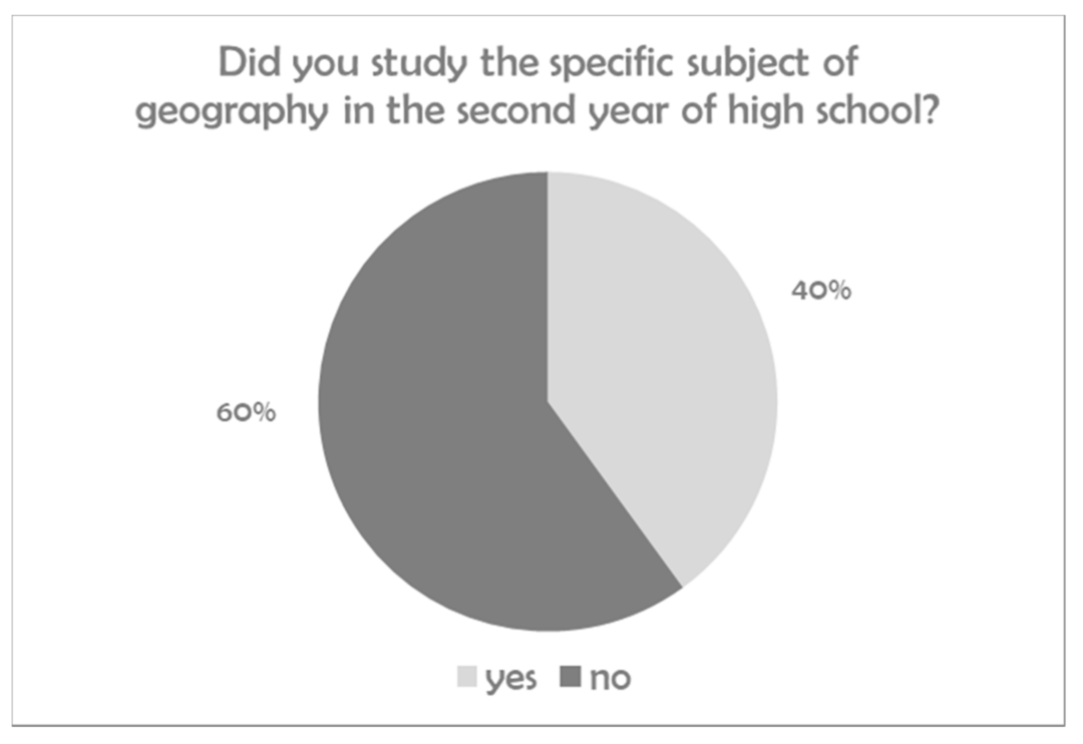
  • How prepared are geography teachers to teach sustainability, particularly SDG numbers 5 and 11?
  • Are any particular needs of training (pre and in service) identified to improve teaching and learning sustainability, particularly SDG numbers 5 and 11?
To measure the degree to which students, who are trainee teachers and higher-education students, have acquired these competencies (specializing in geography and history), a pedagogical design was carried out in four phases. For this, a pre-test and post-test survey was designed and answered by the students throughout the learning project. Our first research question (RQ1) is explored via qualitative analysis of the participation and realization of collaborative mapping in a workshop. The second, third, and fourth research questions (RQ2, RQ3, and RQ4) are explored using quantitative analyses of the survey data.

3.1. Context and Participants

These activity studies were developed during the second four months of the 2019–2020 academic year. A total of 133 students enrolled in the undergraduate course Geography Education (Didáctica de las Ciencias Sociales) in their second year of the Bachelor in Primary Education of the University of Zaragoza participated: 101 (74.2%) women and 32 (25.6%) men. The participants were duly informed and gave their consent to the collection of their answers and data. To address the students’ previous knowledge on sustainability, they were asked whether they had taken geography as a subject in high school (when they were 17 years old, i.e., 3 years earlier). More than half (66%) of the students had not (Figure 1).

3.2. Learning Design: Collaborative Mapping for Effective Teaching of SDGs 5 and 11

The main objective of this methodological design is to provide guidelines or practical approaches for collaborative mapping and participatory processes in general, specifically aimed at schoolteachers, educators, and professionals working in education. This didactic design uses collaborative mapping as a tool to address SDGs 5 and 11, helping to develop a learning strategy in four steps (Figure 2).

Workshop for Collaborative Mapping

The workshop was conducted at the Faculty of Education School at the University of Zaragoza, involving undergraduate students and trainee teachers of geography, to incorporate the gender perspective in the geography and social sciences teaching and learning processes. Thus, a collaborative mapping activity was designed as a means to incorporate the gender perspective as a transversal category in the curriculum, barely implemented in primary and secondary education. This experience (Figure 2) integrates the gender perspective in teaching, research, and didactic implementation, as “scientific, analytical and political vision was created to contribute to the subjective and social construction of a new configuration through a rethink of history, society, culture, and politics from and for women” [33]. Through the visualization of the Las Calles de las Mujeres viewer (in which information on Zaragoza was not yet available), conclusions were drawn about the representation of women in the street maps of Spanish and Latin American cities. Afterward, there was a debate about the number of streets with women’s names that they know in Zaragoza and why these street names are relevant for them.
The workshop also aimed to incorporate gender under the framework of neo-geography in the current social context. This implies a reinvention of geographic science and the normalization of methods, techniques, and tools so non-expert users can use it for personal work or, as in this case, community work. This is how the concept of spatial citizenship [34] is developed focusing on the historical and geographical scarcity of the female figure in the digital and spatial representation of the urban development of our cities. Thus, the response to sustainable development goal (SDG) number 5 is important as it simultaneously evidences the historic gap in the female representation in the roadmaps of cities and normalizes the use of digital technologies, particularly Geographic Information Systems (GIS), to debate and propose solutions for educational change [35].

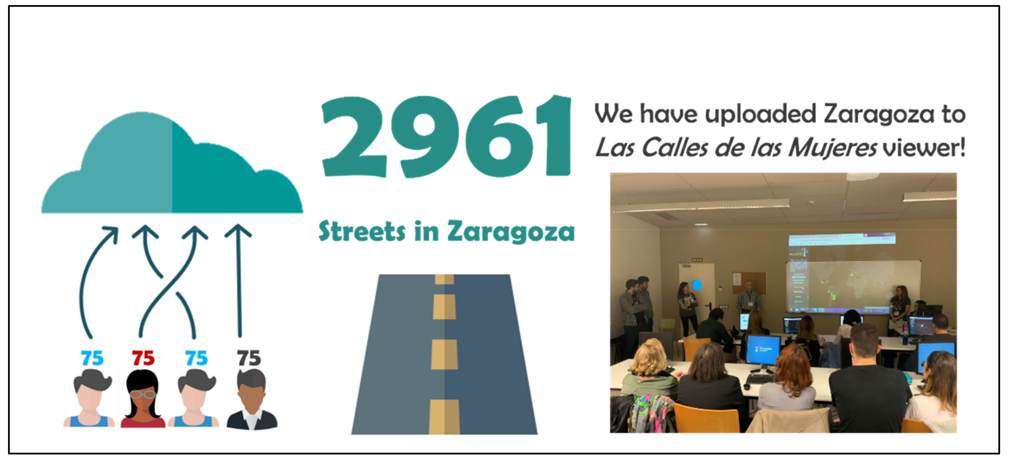
3.3. Collaborative Mapping Methodology

Step 3 of the methodology was designed to guide a non-expert audience in GIS and education, and it is included as a compulsory activity for the bachelor’s degree in primary education and for the master’s degree in secondary education (trainee teachers for geography) at the University of Zaragoza. The inclusion of such activities in the teacher training process is important to create knowledge, improve skills, and introduce the teaching practices of thinking about the past, understanding the present, and overcoming the underestimation of women for a sustainable future. The ultimate goal is to create a collaborative narrative and thus emphasize the importance of gender equality in sustainable cities and communities. The methodology of this workshop consisted in the normalization and correction of the alphanumeric information on road naming stored in the OSM database, identifying the roads named after women, men, and the ones given gender-neutral names (Figure 3).
Once all the roads of the city were extracted, a simple 6-field database was obtained: (i) road name, (ii) gender, (iii) category of the represented person, (iv) type of road, (v) link to Wikipedia, and (vi) validation status and the established spatial–thematic relationship. Secondly, to know and emphasize the value of women represented in Zaragoza’s roadmap, thematic information of women without a Wikipedia page was created and linked (Figure 4). To do this, the collaborative team performed research on every woman without a Wikipedia entry, bearing in mind two references that describe the presence of women in Zaragoza’s street map [46,47].
After the validation of the spatial and thematic information, Zaragoza’s roadmap was uploaded to the Las Calles de las Mujeres web viewer (Figure 5), where there are already 30 represented cities, mainly in Latin America (11 cities) and Spain (13 cities), which can be consulted at https://geochicasosm.github.io/lascallesdelasmujeres, accessed on 27 November 2021.

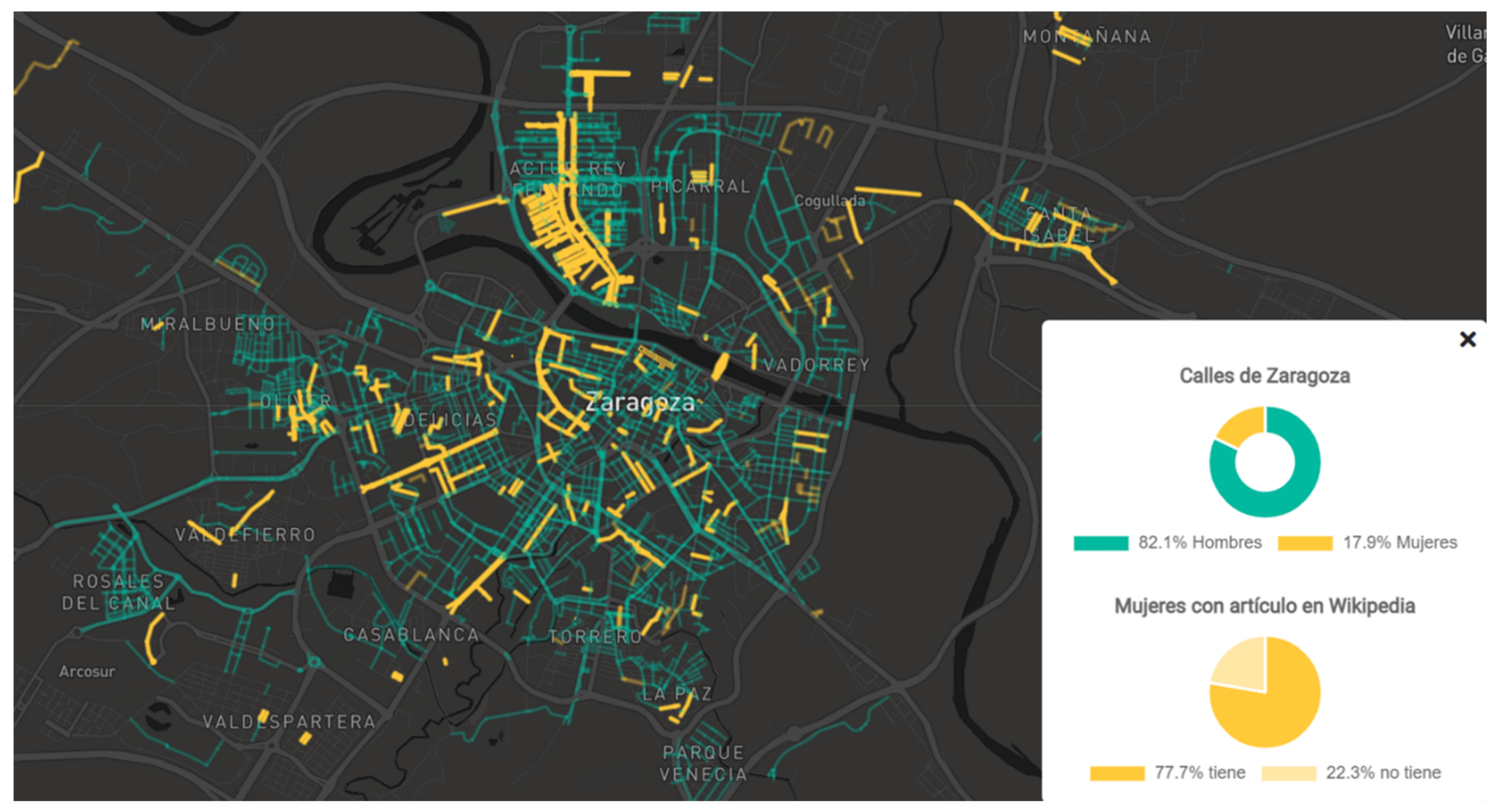
3.4. Upload Zaragoza to the Web Viewer Las Calles de las Mujeres and Analyze and Reflect on the Situation in Zaragoza: Women’s Urban Planning

The workshop MyGEOChicas (MyGEOGirls) was organized as a part of the EU-funded project MyGEO “Geo Tools for Modernization and Youth Employment”. This experience aimed to empower women’s role and her digital presence by means of collaborative mapping of streets in Zaragoza, Spain, named after women celebrated on the International Day of Women and Girls in Science (11 February 2020); it was on that day that the data of the streets of Zaragoza were uploaded to the Women’s Streets Viewer, making known to all citizens of Zaragoza the situation of their city (Figure 6).
Zaragoza is one of the first places in the ranking of Las Calles de las Mujeres cities with the highest percentage of streets named after women, with 18% of the roads dedicated to women (average of 15% among the cities part of the project). This percentage (Figure 7) becomes smaller (8%) when taking into consideration the totality of roads of the city (including those that are not named after a person).
One of the reasons for this is that Zaragoza is one of the largest cities in Spain and it has experienced considerable relative growth in the second half of the 20th century. The city doubled its population between 1951 and 1981 and tripled this growth if we extend the period of analysis until the last available census (2011) [47]. Its urban surface has also increased and now is close to 10,000 hectares. Thus, Zaragoza now has 2961 roads in the official street map. Of these, 223 are named after women (8%), 1090 are named after men (37%), and 55% do not have a determined gender. If this undetermined group is not taken into consideration, the percentage of roads named after women reaches 18%; in other words, of every five roads, four are named after men and only one is named after a woman.
If we look at the type of streets (Figure 8), we see even more remarkable differences related to the female figures represented, since 88% of the main streets and important avenues are named after men and only 12% are named after women. This same pattern is repeated in pedestrian streets (69% male versus 31% female), boulevards (82% male versus 18% female), squares (75% male versus 25% female), bridges (88% male versus 12% female), and roundabouts (100% male).
Lastly, the workshop participants noted that mainly religious female figures are represented in Zaragoza’s street map (34% of the female street names include, e.g., virgin or saint) while about 9% of the female streets are distinguished because of the women’s intellectual work, political power, or contribution to community (Figure 9).
Naming streets is a decision of the City Council made according to the process of urban development, which in recent decades has been produced by impulses and sometimes according to unsustainable urban development patterns. In Europe, new artificial surfaces for urban uses have followed a harmonious development. For example, between 1991 and 2008, the population grew by 9% and artificial surfaces for urban uses by 8%. On the contrary, in Spain, new urban surfaces grew by 52%, which is difficult to sustain with a demographic growth, in the same period, of 17%. In other words, population and urban land uses have grown in Europe at the same rate, but in Spain, artificial surfaces have grown at three times the rate of the population [48]. In Zaragoza, unsustainable rates have been even bigger: a population growth of 11.68% against an urban extension growth of 70.82% (i.e., six times bigger) between 1991 and 2008. In turn, the various stages of urban growth have conditioned the urban morphology, this is, large areas of the city or residential settlements that have been configured by the city extension. Consequently, according to the different urban studies of Zaragoza [49,50,51], urban evolution helps us to establish a female typology of streets more or less in accordance with urban typologies (Figure 10).

3.4.1. Historic City Center

This corresponds to the oldest part of the city, includes the Roman city (Cesaraugusta), and reaches the first urban expansion project, designed to celebrate the Hispanic–French Exposition of 1908. In the historic city, it is worth mentioning that the most important square of the city (Nuestra Señora del Pilar square) has a female name, and it hosts El Pilar Cathedral, La Seo Cathedral, the City Council, and the offices of the national government. At the historic center, there is another group of important streets with the names of female saints, virgins, and other religion-related figures: Santa Lucía, Santa Isabel, Santa Catalina, Santa Engracia, Santa Inés, Santa Lucía, Santa Ana, Carmen Magdalena, and Verónica. In addition, female fighters (city heroes) from the Independence War in the early 19th century are also remembered, with street names such as Manuela Sancho, Casta Alvarez, Agustina de Aragón, Madre Rafols, María Agustín, and Madre Sacramento.

3.4.2. City Extensions until the Mid-Seventies of the 20th Century

From the second decade of the 20th century until the 1970s, the extensions of the city were produced by the application of the Building Ordinance of 1939; by the city blocks zoning expressed in the 1968 Master Plan; by the densification process in compacted neighborhoods, such as Delicias, San José, and Las Fuentes; or by new plans of city extension (Ensanches), such as Gran Vía and Miraflores.
In this area, there is a broad diversity of street names: queens, princesses, and nobles (Isabel la Católica, Reina Fabiola, Reina Felicia, Duquesa Villahermosa, Violante de Hungría, Doña Blanca de Navarra, María de Aragón, and Germana de Foix), religion-related figures (Santa Teresa de Jesús, Madre Vedruna, Santa Gema, Nuestra Señora de las Nieves, and Santa Orosia), and intellectuals and artists (María Moliner, Concepción Arenal, Eugenia Bueso, Pilar Bayona, Pilar Lorengar, and Raquel Meller).

3.4.3. Social Housing Developments

These were built between 1942 and 1975 under Franco’s Ministry of Housing (Obra Sindical del Hogar, Patronato Municipal de la Vivienda, Instituto Nacional de la Vivienda). Today, these qualify as contemporary heritage by the current Master Plan. In the La Jota neighborhood, different traditional music singers, such as Pascuala Perié, Felisa Galé, Asunción Delmás, and María Blasco, give their names to popular streets. In the Picarral neighborhood, some female scientists are also commemorated (María Sánchez Abós, María Domínguez Castellanos, and Teresa Agüesca), while in the Las Fuentes neighborhood, there are several streets with names of monasteries named after females (Sigena, Valvanera, Guayente, Leyre, Obarra, Roncesvalles, etc.).

3.4.4. Recent Neighborhoods Planned in 1968, 1986, and 2001 Master Plans

The most important area in terms of extension and housing and population capacity is the ACTUR district. It was planned during the 1970s, although its construction, urbanization, and consolidation did not materialize until the democratic era (the 1980s). Otherwise, the maximum number of streets named after women in Zaragoza are found here, and in particular, the two main roads and urban axis have female names (Gertrudis Gómez de Avellaneda and María Zambrano). Several perpendicular streets are also named after female writers: Margarita Xirgú, Emilia Pardo Bazán, Concepción Sainz de Otero, Clara Campoamor, María Zayas, Rosalía de Castro, Mariana Pineda, and María de Luna. Here, it is possible to walk more than 20 km using only those pedestrian roads that are named after women, which is unusual.
Another development district plan designed in the Master Plan of 1986 built roads with female names (Reina Ermesinda de Aragón, 89th sector; Rosa María Aranda, Pilar Delgado y Santas Nunila y Alodia, 71st sector). In Parque Goya district, many of the streets are dedicated to the life of the famous Aragón painter Francisco de Goya and his works: Las hilanderas, Josefa Bayeu, and Condesa de Chinchón streets. EcoCity Valdespartera, built in the 21st century, has many names related to famous films and the film industry: Mary Poppins, Mrs. Miniver, and Penélope Cruz lakes. The decision to name the streets of these areas of the city was made by democratic city councils issued after the 1979 elections and subsequent local government elections.

3.4.5. Suburban Districts

Santa Isabel is simultaneously the female name of the suburban district and its main street. Other suburban districts are also named after religious figures: Santa Ana, Santa Bárbara, Carmen, Rosario, etc.

3.4.6. Streets Not Included in the Aforementioned Groups

Lastly, there are roads with female names without a clear connection with the urban pattern or designed areas or neighborhoods. This happens in the Oliver neighborhood (Teodora Lamadrid and Reina Petronila), the Valdefierro neighborhood (Francisca Millán and Galatea), and in industrial zones such as Cogullada (Isabel Santo Domingo and Ana Abarca de Bolea).

3.5. Design of Learning Activities

With all the material resulting from this workshop, students designed activities adapted to primary and secondary school levels in which geographic competencies were developed. The starting point is the idea that geographic competencies contribute to the knowledge linked to the fulfillment of the SDGs as they allow the identification of numerous problems linked to sustainable development, their localization and analysis, and drawing conclusions that, together with critical thinking, provide students with the necessary skills and competencies to become active agents of the changes associated with the fulfillment of the SDGs. These competencies constitute the main conceptual and procedural training for students to understand the challenges of today’s world, specifically those related to gender equality and sustainable cities. This is a basic and essential principle for the formation of a new citizenship and has the vocation to reform education and society.

4. Results

Once the collaborative mapping of the streets named after women in the city of Zaragoza was completed, the second part of the research used this cartographic resource to explore the knowledge, difficulties, and challenges of geography teachers in training in relation to the teaching of the SDGs and, in particular, with the two most closely related to the MyGEOChicas project: gender equality and sustainable cities. The questionnaire design took into consideration experiences of previous research on pre-service teachers’ perceptions and knowledge for teaching SDGs [17,52,53], using five dimensions related to the research questions for the analysis, which arose from theory and were predefined and agreed upon by the researchers. The dimensions respond to the purpose of the process itself: training in education on SDGs. It is also important to know what SDGs mean to the students. In relation to this, it is also essential to find out what they know about the SDGs and, especially, what they know about the teaching strategies to integrate education on SDGs in their professional competencies and in their future teaching practice.
The analysis dimensions put forward were:
  • Dimension 1: Knowledge of the SDGs from trainee teachers.
  • Dimension 2: Pedagogical knowledge and selected learning strategies.
  • Dimension 3: Urban geographical knowledge: the city of Zaragoza as a laboratory for urban sustainability.
  • Dimension 4: Gender and urban inclusion awareness.
  • Dimension 5: SDG teaching competencies.
The information obtained is organized by dimensions and the levels (hereafter L) that constitute them. The results of the four phases of the training process are described in Section 4.
A total of 133 students in the teacher training program for primary education participated in this study. The results of the assessment of competencies in SDGs were collected according to the five established domains. For this purpose, a pre-test and post-test survey was prepared, with the aim of measuring the degree of acquisition of these competencies through the instructional resource “Mapping the streets of the women of Zaragoza”. At the beginning of the 2019–2020 course, the students were evaluated by means of a test: (i) their degree of knowledge of the SDGs, (ii) the relevance of each of them, and (iii) knowledge of the streets (by spatial location and gender) of Zaragoza in order to have self-knowledge of their initial teaching competencies. After one semester, in which the different methodological approaches and didactic resources for education on sustainable development were implemented, and particularly through the collaborative mapping workshop, the students repeated the test individually (Table 2). Excel was used to analyze the level of acquisition of competencies and NVivo 12 Plus software was used to obtain the coding matrices that allowed for the extraction of the frequencies and the organization of the results to study the pre-test and post-test data and therefore the level of competencies.

4.1. Knowledge of the SDGs

This dimension was measured through closed questions on the learning objectives to be achieved in the 17 SDGs, according to the proposal made by UNESCO in its document on Education for Sustainable Development Goals [17]. In the initial phase, as shown by the pre-test (Table 3), more than 50% of the students had a level 2. After the implementation of the didactic activities, 66% of the students reached a level 3, and it is noteworthy that more than 15% of them knew the SDGs and would know how to implement them in their teaching practices.

4.2. Pedagogical Knowledge

In this dimension, a rubric on the design of a didactic strategy for teaching the SDGs in social sciences was evaluated, with special emphasis on students as active agents of change, which included (i) the analysis of reality with data, maps, etc., (ii) scientific evaluation of the situation, and (iii) proposal of possible changes or resolution of the challenge posed. It is noteworthy that in the initial phase, more than 60% of the students were at level 1, a figure that was inverted after the didactic activities were carried out, obtaining in the post-test the highest percentages (67%) in level 4 (Table 4). The vast majority of students have proposed project work or problem-solving methodologies to address issues of education for sustainable development.

4.3. Urban Geographical Knowledge

More than 75% of the students had no or almost no urban knowledge of the city of Zaragoza. Despite the fact that most of them live in the same city, they were unaware of its recent urban unsustainable growth and spatial distribution, as can be seen in the results of the pre-test in Table 5.
To the questions (i) cite at least five streets in Zaragoza named after women that you know and (ii) locate those streets in the neighborhoods to which they belong, the students demonstrated an increase in their knowledge. Therefore, we can affirm that, because of activities such as fieldwork, learning itineraries, and collaborative mapping, a spatial analysis of the map of Zaragoza was carried out which resulted in 63% of the students having increased urban knowledge (to a level 3).
Nevertheless, there are still problems in identifying the neighborhoods in which streets named after women are mostly located, as well as their spatial distribution according to the social composition of neighborhoods. There were two particular streets named after women that were identified by students (María Zambrano and Maria Moliner): the first one because it hosts one of the biggest malls in the city and the other one because it is also the name of the university library.
To promote spatial citizenship, students were asked whether they would be able to walk home from the faculty only on streets named after women. The vast majority of them said they would not be able to make the journey without having to walk on streets named after men.

4.4. Gender and Urban Inclusion Awareness

To begin with, 91% of the students did not know about women’s urban planning in Zaragoza (see Table 6, Level 1, pre-test), but after attending the workshop, their knowledge increased and 24% were able to develop teaching practices on gender urban planning (Table 6).
Coming back to the question “Do you think that women are sufficiently represented in the street map of Zaragoza?”, data scores of both pre-test and post-test are similar in both cases; the answer was no for 90% of them.
In addition, on being asked what they would do to change it, the answers were that they would give more importance to the work and labor of women and make society aware of the importance of women in the history of Zaragoza.

4.5. SDG Teaching Competence

This dimension was assessed both through the design of its activities (with the rubric discussed in Section 4.1) and through the following questions:
  • Do you think the MyGEOGirls workshop could be used to teach SDGs 5 and 11 to social studies students?
  • Why?
  • Define your didactic design.
Before the workshop and the course, more than 52% of the students had vague knowledge regarding geographic education for sustainable development (see pre-test data in Table 7). However, after six ECTS credits of this subject were taken and activities such as those described in this publication were carried out, the students had acquired sufficient knowledge to explain the SDGs (63% acquired a competence level of 3) and 26% were able to efficiently address geographical education for sustainable development in the classroom.
In fact, the students were grateful for having been able to develop activities such as those proposed for learning to learn, learning to do, and learning to be. They felt that they were actors of change due to the great repercussion that the workshop had in the press, which has brought to the attention of the local society the relevant problem of the scarce representation of women in the urban planning of Zaragoza. Thus, this has contributed to creating powerful knowledge to foster education for sustainable development goals in primary education according to the national curriculum.

5. Discussion

This study focused on exploring the change in perceptions and skills of trainee teachers in primary and secondary education with respect to GIS, and specifically collaborative mapping, as a tool to support geography teaching. The students participated in a training process involving four steps, in which, through the use of geospatial tools, effective teaching of sustainable development goals 5 (gender equality) and 11 (sustainable cities and communities) was carried out in an integrated manner.
The results of this project confirm that student teachers are able to carry out collaborative mapping projects to create enormous knowledge, to put skills into practice, and to raise awareness of targets in relation to concrete sustainable development goals [32,54]. In this way, the result of the first research question is confirmed and the importance of learning new digital tools as a process of teacher training empirically verified [2,6,8,23].
During the mapping process and, above all, the final analysis of the urban cartography of Zaragoza in the women’s street map viewer (with percentages of women’s street names and digital representation), the future teachers were aware of the great digital and gender gap in Zaragoza’s street map, a situation that, as could be gathered from the debate generated after the analysis of the data extracted from the street map, was unknown to more than 90% of the students. Similarly, teachers identified the 17 goals for sustainable development with relative accuracy, although they did not show a particular collective preference for any of them. On the contrary, this type of experience allowed them to know and deepen their knowledge of some of them to analyze the targets and indicators in order to apply them to teaching in the immediate social environment [1,13,24,53]. In other words, the teachers were able to take advantage of the didactic potential of the objectives for sustainable development in their daily practice of curricular development of geographic contents related to the city, the social space, or the environmental challenges, transforming their knowledge of the SDG goals and targets into knowledge of the SDG learning objectives they should set for themselves as future teachers. Thus, geography, and in particular collaborative mapping, appears as an outstanding science able to face the complexity and diversity of processes, systems, and interconnections between human and natural environments by developing, in students, analytical thinking (data, visualization, etc.), critical thinking (judgment, assessment, etc.), and, especially, lateral thinking (creative, problem solving, etc.).

6. Conclusions and Future Research Orientations

Projects in education, such as the experimentation described in this article, contribute to the acquisition of two geographical-specific competencies for lifelong learning: spatial thinking and spatial citizenship. Trainee teachers have recognized the usefulness of geography education for students in cognitive processes and social and personal skills, related to the following competencies: spatial conceptualization and spatial representation of gender imbalances; spatial reasoning in location, distribution, and spatial patterns of urban development; processing of geospatial information related to street names; evaluation of spatial data to represent social targets such as gender balance; and communication on and participation in the cyberspace to express challenges and solutions for citizen’s rights, such as social inclusion and urban rights (housing, transportation, public services, environment, etc.).
It is obvious that men and women are not equally represented in the public space, and this has important consequences for how to conceive and interact in the urban environment. In this sense, collaborative mapping initiatives, such as the workshop MyGEOGirls, can contribute to people’s gender balance education that, simultaneously, increases their knowledge about the city in which they live and the challenges related to urban sustainable development (making the historically relevant women of their city visible in the public space). The social impact of the work on the streets of Zaragoza named after women is the increase in reflection on the scarce presence of women in the streets and the need for equity in terms of street names in the new neighborhoods.
This confirms that the GIS community users, in general, and geographers and geography educators, in particular, are able to implement collaborative projects to achieve sustainable development goals, such as SDG numbers 5 and 11. In particular, neo-geography and volunteered geographic information are important contributions to taking a position on certain social challenges (such as gender balance and sustainable urban development) based not on unfounded opinions but on shared, reliable, and accurate data, providing empirical evidence on the status of a given sustainable development goal, in a given space and at a given time, even for non-professional geographers, such as geography educators in primary and secondary education.
However, research shows certain limitations in the spatial knowledge of trainee teachers. Most of them only know of streets named after the most important women, particularly those that are an official address of a mall or an important transit hub. In only a few cases they were able to identify more than five streets or were able to explain the process of growth of the city. Regardless, the model is created to be replicable in other cities and teacher training contexts—so much so that this March, the experience has been replicated with 14-year-old students, in the classroom of a teacher who participated in the learning experience presented here. Otherwise, trainee teachers were aware of their shortcomings in teaching sustainable development goals, not so much in terms of teaching strategies or learning pedagogies but in terms of social knowledge and technology related to spatial thinking.
This leads us to the final conclusion: participants in the workshop and the survey recognized that it is essential to continue to reinforce the pre- and in-service teacher training using cartographic tools that allow them to carry out case studies of their immediate social space, information they must teach their school students to fulfill curriculum requirements, and also, in a broad sense, sustainable development goal education.

Author Contributions

R.d.M.G. and M.S.-L. have contributed equally to this work. All authors have read and agreed to the published version of the manuscript.

Funding

This research was funded by the European Union Projects MyGEO (2018-1-IT02-KA203-048195) and INPAD (2020-1-FR01-KA201-079871), and it has been implemented at IUCA-UNIZAR, Institute of Research into Environmental Sciences of Aragón, University of Zaragoza.

Acknowledgments

We would like to thank the participating students for their contribution to our research. We also thank the geospatial communities GeoChicas OSM (especially Carmen Diez, Jessica Sena and María Zuñiga) and GeoInquietos for their contribution to the collaborative mapping workshop.

Conflicts of Interest

The authors declare no conflict of interest.

References

  1. De Miguel, R. Europe in a global context: Eurogeo and the role of geography and European geographers. Eur. J. Geogr. 2019, 10, 160–176. [Google Scholar]
  2. De Miguel, R.; Donert, K.; Koutsopoulos, K. (Eds.) Geospatial Technologies in Geography Education; Springer: Cham, Switzerland, 2019. [Google Scholar]
  3. Georgeson, L.; Maslin, M. Putting the United Nations Sustainable Development Goals into practice: A review of implementation, monitoring and finance. Geo Geogr. Environ. 2018, 5, e00049. [Google Scholar] [CrossRef]
  4. Liverman, D. Geographic perspectives on development goals: Constructive engagements and critical perspectives on the MDGs and the SDGs. Dialogues Hum. Geogr. 2018, 8, 168–185. [Google Scholar] [CrossRef] [Green Version]
  5. Liverman, D. Development goals and geography: An update and response. Dialogues Hum. Geogr. 2018, 8, 206–211. [Google Scholar] [CrossRef]
  6. Nightingale, A. Geography’s contribution to the Sustainable Development Goals: Ambivalence and performance. Dialogues Hum. Geogr. 2018, 8, 196–200. [Google Scholar] [CrossRef]
  7. Sultana, F. An(Other) geographical critique of development and SDGs. Dialogues Hum. Geogr. 2018, 8, 186–190. [Google Scholar] [CrossRef]
  8. Fu, B. Promoting Geography for Sustainability. Geogr. Sustain. 2020, 1, 1–7. [Google Scholar] [CrossRef]
  9. Chang, C.; Kidman, G.; Wi, A. Issues in Teaching and Learning of Education for Sustainability; Routledge: New York, NY, USA, 2020. [Google Scholar]
  10. Meadows, M. Geography Education for Sustainable Development. Geogr. Sustain. 2020, 1, 88–92. [Google Scholar] [CrossRef]
  11. Sprenger, S.; Nienaber, B. (Education for) sustainable development in geography education: Review and outlook from the perspective of Germany. J. Geogr. High. Educ. 2017, 42, 157–173. [Google Scholar] [CrossRef]
  12. De Lázaro, M.; Borderías, P.; Morales, F. Citizen and Educational Initiatives to Support Sustainable Development Goal 6: Clean Water and Sanitation for All. Sustainability 2020, 12, 2073. [Google Scholar] [CrossRef] [Green Version]
  13. Jeronen, E. Geography Education Promoting Sustainability; MDPI: Basel, Switzerland, 2020. [Google Scholar]
  14. De Miguel, R. Geographical and geospatial competences from school education to higher education: The contribution of EUROGEO in the international projects. J. Res. Didact. Geogr. (J-READING) 2021, 2, 10. [Google Scholar]
  15. European Commission. Towards a Sustainable Europe by 2030; European Commission: Brussels, Belgium, 2019. [Google Scholar]
  16. SDSN. Accelerating Education for the SDGs in Universities: A Guide for Universities, Colleges, and Tertiary and Higher Education Institutions; Sustainable Development Solutions Network: New York, NY, USA, 2020. [Google Scholar]
  17. UNESCO. Education for Sustainable Development Goals—Learning Objectives; United Nations Educational, Scientific and Cultural Organization: Paris, France, 2017. [Google Scholar]
  18. Albareda-Tiana, S.; García-González, E.; Jiménez-Fontana, R.; Solís-Espallargas, C. Implementing Pedagogical Approaches for ESD in Initial Teacher Training at Spanish Universities. Sustainability 2019, 11, 4927. [Google Scholar] [CrossRef] [Green Version]
  19. Albareda-Tiana, S.; Vidal-Raméntol, S.; Pujol-Valls, M.; Fernández-Morilla, M. Holistic Approaches to Develop Sustainability and Research Competencies in Pre-Service Teacher Training. Sustainability 2018, 10, 3698. [Google Scholar] [CrossRef] [Green Version]
  20. Reinfried, S.; Schleicher, Y.; Rempfler, A. (Eds.) Geographical Views on Education for Sustainable Development. In Proceedings of the Lucerne-Symposium, Lucerne, Switzerland, 29–31 July 2007; Geographiedidaktische Forschungen. p. 42. [Google Scholar]
  21. De Miguel, R. From international to global understanding: Toward a century of international geography education. Int. Res. Geogr. Environ. Educ. 2021, 3, 202–217. [Google Scholar] [CrossRef]
  22. Yli-Panula, E.; Jeronen, E.; Lemmetty, P. Teaching and Learning Methods in Geography Promoting Sustainability. Educ. Sci. 2020, 10, 5. [Google Scholar] [CrossRef] [Green Version]
  23. Sebastián, M.; de Miguel, R. Mobile Learning for Sustainable Development and Environmental Teacher Education. Sustainability 2020, 12, 9757. [Google Scholar] [CrossRef]
  24. Kidman, G.; Chang, C.; Wi, A. Defining education for sustainability. A theoretical framework. In Issues in Teaching and Learning of Education for Sustainability; Chang, C., Kidman, G., Wi, A., Eds.; Routledge: New York, NY, USA, 2020; pp. 1–14. [Google Scholar]
  25. Rickles, P.; Ellul, C.; Haklay, M. A suggested framework and guidelines for learning GIS in interdisciplinary research. Geo Geogr. Environ. 2017, 4, e00046. [Google Scholar] [CrossRef]
  26. Hong, J.E.; Stonier, F. GIS in-service teacher training based on TPACK. J. Geogr. 2015, 114, 108–117. [Google Scholar] [CrossRef]
  27. De Miguel, R.; de Lázaro, M.L. WebGIS Implementation and Effectiveness in Secondary Education Using the Digital Atlas for Schools. J. Geogr. 2020, 119, 74–85. [Google Scholar] [CrossRef]
  28. Baker, T. WebGIS in education. In Geospatial Technologies and Geography Education in a Changing World: Geospatial Practices and Lessons Learned; Muñiz, O., Demirci, A., van der Schee, J., Eds.; Springer: Cham, Switzerland, 2015; pp. 105–115. [Google Scholar]
  29. Kerski, J.; Baker, T. Infusing educational practice with Web GIS. In Geospatial Technologies in Geography Education; de Miguel, R., Donert, K., Koutsopoulos, K., Eds.; Springer: Cham, Switzerland, 2019; pp. 3–19. [Google Scholar]
  30. Kerski, J. What Are the 10 Most Important Educational Benefits That GIS Fosters? ESRI: Redlands, CA, USA, 2021. [Google Scholar]
  31. Fargher, M. The Role of Geography and Geospatial technologies in taking on the world. In Geospatial Technologies in Geography Education; de Miguel, R., Donert, K., Koutsopoulos, K., Eds.; Springer: Cham, Switzerland, 2019; pp. 175–182. [Google Scholar]
  32. Álvarez, J.; de Lázaro, M.L. Education in Sustainable Development Goals Using the Spatial Data Infrastructures and the TPACK Model. Educ. Sci. 2018, 8, 171. [Google Scholar] [CrossRef] [Green Version]
  33. García, A.; Peinado, M. LOMCE: ¿es posible construir una ciudadanía sin la perspectiva de género? Iber Didact. Cienc. Soc. Geogr. Hist. 2015, 80, 65–72. [Google Scholar]
  34. Gryl, I.; Jekel, T. Spatially Informed Citizenship Education as an Approach for Global Understanding. In Geography Education for Global Understanding; Demirci, A., de Miguel, R., Bednarz, S., Eds.; Springer: Cham, Swizterland, 2018; pp. 43–56. [Google Scholar]
  35. Goodchild, M. Citizens as sensors: Web 2.0 and the volunteering of geographic information. Geofocus 2008, 7, 8–10. [Google Scholar]
  36. Criado, J.I.; Guevara-Gomez, A. Public sector, open innovation, and collaborative governance in lockdown times. A research of Spanish cases during the COVID-19 crisis. Transform. Gov. People Process Policy 2021, 15, 612–626. [Google Scholar] [CrossRef]
  37. Spellman, K.; Mulder, C. Validating herbarium-based phenology models using citizen-science data. BioScience 2016, 66, 897–906. [Google Scholar] [CrossRef]
  38. Domroese, M.; Johnson, E. Why watch bees? Motivations of citizen science volunteers in the Great Pollinator Project. Biol. Conserv. 2017, 208, 40–47. [Google Scholar] [CrossRef]
  39. Kwan, M. Feminist visualization: Re-envisioning GIS as a method in feminist geographic research. Ann. Assoc. Am. Geogr. 2002, 92, 645–661. [Google Scholar] [CrossRef]
  40. Pavlovskaya, M.; Martin, K. Feminism and geographic information systems: From a missing object to a mapping subject. Geogr. Compass 2007, 1, 583–606. [Google Scholar] [CrossRef]
  41. Rose, G. Feminism and Geography; University of Minnesota Press: Minneapolis, MN, USA, 1993. [Google Scholar]
  42. Ferreira, E.; Salvador, R. Lesbian collaborative web mapping: Disrupting heteronormativity in Portugal. Gend. Place Cult. 2015, 22, 954–970. [Google Scholar] [CrossRef]
  43. Young, C. HarassMap: Using crowd sourced data to map sexual harassment in Egypt. Technol. Innov. Manag. Rev. 2014, 4, 7–13. [Google Scholar] [CrossRef]
  44. Gardner, Z.; Mooney, P.; de Sabbata, S.; Dowthwaite, L. Quantifying gendered participation in OpenStreetMap: Responding to theories of female (under) representation in crowd sourced mapping. GeoJournal 2020, 85, 1603–1620. [Google Scholar] [CrossRef] [Green Version]
  45. González, M. Geochicas, Improving How Open Mapping Represents the World. In Proceedings of the 2021 IEEE International Geoscience and Remote Sensing Symposium IGARSS, Brussels, Belgium, 11–16 July 2021; IEEE: Piscataway, NJ, USA, 2021; pp. 40–42. [Google Scholar]
  46. Álvarez, G.; Baselga, C.; Gaudó, C.; Romeo, C.; Torres, I.; Verón, A. Paseos por la Zaragoza de las Mujeres; Ayuntamiento de Zaragoza: Zaragoza, Spain, 2019. [Google Scholar]
  47. Romeo, C.; Álvarez, G.; Baselga, C.; Gaudó, C. Callejero: La Zaragoza de las Mujeres; Ayuntamiento de Zaragoza: Zaragoza, Spain, 2010. [Google Scholar]
  48. De Miguel, R. Geomedia for Education in Sustainable Development in Spain. An experience in the framework of the aims of Digital-Earth.Eu. Eur. J. Geogr. 2012, 3, 44–56. [Google Scholar]
  49. De Miguel, R. Transformación urbana y procesos territoriales recientes en Zaragoza y su espacio metropolitano. Estud. Geográficos 2015, 278, 63–106. [Google Scholar] [CrossRef] [Green Version]
  50. Marco, R.; Buil, C. Zaragoza 1908–2008. Arquitectura y Urbanismo; Colegio Oficial de Arquitectos de Aragón: Zaragoza, Spain, 2009. [Google Scholar]
  51. Monclús, J.; Labarta, C.; Díez, C.; Agustín, L.; Bergera, I. Paisajes Urbanos Residenciales en la Zaragoza Contemporánea; Prensas Universitarias de Zaragoza: Zaragoza, Spain, 2012. [Google Scholar]
  52. Costa, J.; Cancela, D.; Reis, J. Neverland or Tomorrowland? Addressing (In)compatibility among the SDG Pillars in Europe. Int. J. Environ. Res. Public Health 2021, 18, 11858. [Google Scholar] [CrossRef] [PubMed]
  53. García-González, E.; Jiménez-Fontana, R.; Azcárate, P. Education for Sustainability and the Sustainable Development Goals: Pre-Service Teachers’ Perceptions and Knowledge. Sustainability 2020, 12, 7741. [Google Scholar] [CrossRef]
  54. Akbar, A.; Flacke, J.; Martinez, J.; Aguilar, R.; van Maarseveen, M.F.A.M. Knowing My Village from the Sky: A Collaborative Spatial Learning Framework to Integrate Spatial Knowledge of Stakeholders in Achieving Sustainable Development Goals. ISPRS Int. J. Geo-Inf. 2020, 9, 515. [Google Scholar] [CrossRef]
Figure 1. Students’ prior knowledge of geography, 2019–2020 academic year.
Sustainability 14 04042 g001
Figure 2. Didactic design steps carried out with students of education during the 2019–2020 academic year.
Sustainability 14 04042 g002
Figure 3. The first step in the methodological process of the workshop: normalization and identification of genders of the names of the streets in Zaragoza.
Sustainability 14 04042 g003
Figure 4. The second step in the methodological process of the workshop: updating Wikipedia to create entries for women currently without information.
Sustainability 14 04042 g004
Figure 5. The third step in the methodological process of the workshop: georeferencing streets in Zaragoza named after women.
Sustainability 14 04042 g005
Figure 6. Call for the collaborative mapping workshop on the International Day of Women and Girls in Science. Media coverage of the results of the project.
Sustainability 14 04042 g006
Figure 7. Street names in Zaragoza, by gender.
Sustainability 14 04042 g007
Figure 8. Gender of street names in Zaragoza, by type of road.
Sustainability 14 04042 g008
Figure 9. Typology of female figures represented in Zaragoza’s roadmap according to OSM categorization.
Sustainability 14 04042 g009
Figure 10. Streets map of Zaragoza’s roadmap published on the Las Calles de las Mujeres web viewer. In green, streets named after men. In yellow, streets names after women. Source: https://geochicasosm.github.io/lascallesdelasmujeres/, accessed on 27 November 2021.
Sustainability 14 04042 g010
Table 1. Connections between geography and SDGs.
SDG Geographical Branches
1No povertySocial and economic geography
2Zero hungerSocial and rural geography
3Good health and well-beingSocial geography
4Quality educationSocial geography
5Gender equalitySocial geography
6Clean water and sanitationHydrogeography
7Affordable and clean energyIndustrial geography
8Decent work and economic growthEconomic geography
9Industry, innovation, and infrastructureTransport and economic geography
10Reduced inequalitiesRegional geography
11Sustainable cities and communitiesUrban geography
12Responsible consumption and productionEconomic geography
13Climate actionClimatology
14Life below waterBiogeography and hydrogeography
15Life on landBiogeography
16Peace, justice, and strong institutionsPolitical geography
17Partnerships for the goalsPolitical geography
Source: De Miguel, 2019.
Table 2. Definitive analysis system.
LevelD1:
Knowledge of the SDGs
D2:
Pedagogical Knowledge
D3:
Urban Geographical Knowledge
D4:
Gender and Urban Inclusion Awareness
D5:
SDG Teaching Competence
1They are not familiar with them.
2Their knowledge is vague.
3They know it and know how to explain it.
4They know it and know how to implement it in their teaching practice.
Table 3. Units of information (UIs) for the dimension of knowledge of the SDGs.
LevelL1L2L3L4
Pre-test1870405
Post-test5238520
Table 4. Units of information (UIs) for the dimension of pedagogical knowledge.
LevelL1L2L3L4
Pre-test8141110
Post-test3162490
Table 5. Units of information (UIs) for the dimension of urban geographical knowledge.
LevelL1L2L3L4
Pre-test1012840
Post-test4128532
Table 6. Units of information (UIs) for the dimension of gender and urban inclusion awareness.
LevelL1L2L3L4
Pre-test122650
Post-test39372532
Table 7. Units of information (UIs) for the dimension of SDG teaching competence.
LevelL1L2L3L4
Pre-test868552
Post-test5108435
Publisher’s Note: MDPI stays neutral with regard to jurisdictional claims in published maps and institutional affiliations.

