Article

Assessment and Promotion Strategy of Rural Resilience in Yangtze River Delta Region, China

School of Tourism and Urban-Rural Planning, Zhejiang Gongshang University, Hangzhou 310018, China
*
Authors to whom correspondence should be addressed.
Sustainability 2022, 14(9), 5382; https://doi.org/10.3390/su14095382
Submission received: 8 April 2022 / Revised: 23 April 2022 / Accepted: 27 April 2022 / Published: 29 April 2022

Abstract

:
The Yangtze River Delta region is the most economically active and open region in China. It is also the region with the most prominent contradictions between urban and rural development. Therefore, it is necessary to strengthen the resilience of the rural areas in this region so that they can develop further with resources and opportunities after sustaining shocks. This study used a weighted TOPSIS method to measure the rural resilience of 153 research units from 2000 to 2019 and then applied the ESDA method to measure the spatial agglomeration or heterogeneity characteristics. The results show that: (1) The rural resilience of this region is higher in the east and lower in the west; (2) rural resilience has obvious spatial agglomeration characteristics, which have undergone a process of shifting from strong to weak before becoming strong again; and (3) the hotspots of rural resilience gradually shifted from Jiangsu to Zhejiang, while the coldspots gradually shifted from Zhejiang to Anhui. Finally, the K-means clustering algorithm was applied to divide all research units into five types: natural capital-dominated areas, productive capital-dominated areas, human capital-dominated areas, social-financial capital-dominated areas and general development areas. Then, the strategies for resilience promotion were proposed accordingly.

1. Introduction

Since the 21st century, against the backdrop of economic globalization, cultural diversity and the accelerated development of information technology, economic crises, food security, climate change and other related issues have become more prominent, and, as a result, the uncertainties surrounding and the vulnerabilities of global rural development have gradually increased [1,2,3]. Such factors manifest themselves in different forms in different rural areas around the world. In Western Europe, rural development in Germany lags behind, resulting in insufficient infrastructure, employment opportunities and the supply of public services, which eventually leads to a large number of rural people being forced to work and live in cities [4]. In northern Europe, growth in rural Sweden has slowed and signs of decline are evident [5]. In Asia, Japan’s rural areas are faced with a wide range of problems such as population loss and aging [6]. As for China, it has the largest population in the world, and the registered population in rural areas accounts for 40% of the total population. As a result, rural problems in China are more diverse and complex than those in other countries [7,8]. Consequently, how to develop and revitalize rural areas has always been a research hotspot in sociology, geography and economics at home and abroad.
Rural areas are complex systems consisting of economic, cultural, social and ecological factors, with many characteristics which are different from urban areas [9,10,11]. Our understanding of rural areas can be different depending on the perspective. In as early in 1987, Yuan defined a rural area as a total social area containing settlements of different sizes (such as villages and market towns) [12]. From the viewpoint of social relations, a rural area is a cultural-economic community based on residential function which, to a certain extent, has autonomous status [13]. From a spatial perspective, a rural area is the general term for a settlement in which residents take agriculture as the basic content of economic activity [14]. And in the context of urbanization, the functions of rural areas are constantly changing, making it more difficult to define the concept. Therefore, our understanding of what defines a rural area is often vague and perceptual, and academic circles have not been able to provide a clear definition.
The word ‘resilience’ comes from the Latin ‘resilio’, which means to return to the original state. In 1973, Holling first applied the concept of resilience to ecology. With the deepening of research on resilience, the concept has been discussed by many scholars from different disciplines, mainly from the fields of ecosystem research, disaster management research, organizational research, etc. [15,16,17,18]. Generally, the concept of resilience has undergone an evolution from a single equilibrium to multiple equilibria and then to the pursuit of an adaptive cycle instead of absolute equilibrium [19]. As a result of this process, the concept of resilience has changed [20,21,22,23]. Initially, resilience referred to the ability of a system to withstand external shocks while ensuring the operation of its core functions, focusing on the stability of the system. Later, the concept of resilience began to emphasize the ability of the system to learn and adapt after the restoration of stability, that is, the ability of the system to take advantage of resources and opportunities for further development after sustaining shocks [24]. This study defines resilience as the latter, thus abandoning the pursuit of absolute equilibrium and emphasizing continuous adaptation, learning and innovation in the face of shocks to make the system stronger.
Resilience theory can be combined with various entities, and the properties of entities become the basis for resilience. Therefore, compound concepts such as ‘urban resilience’, ‘psychological resilience’ and ‘economic resilience’ have emerged. Similar to urban areas, rural areas can also be considered as entities. Although rural areas have always faced industrial, cultural and ecological uncertainties, the concept of resilience has rarely been applied to analyze specific rural issues. In view of this, Heijman firstly combined the concept of rural entities with resilience theory and proposed the novel concept of ‘rural resilience’ to describe the flexibility of a rural system to adapt to major external shocks, that is, the ability of a rural system to change from one state to another when external disturbances occur [25]. In other words, rural resilience tends to act as a buffer that protects rural areas from external harm.
Comparing rural resilience with urban resilience, it can be found that urban resilience studies focus on economic and social factors, while rural resilience studies pay more attention to agriculture, ecology and other factors that are closely related to rural industrial development [26,27,28,29]. Therefore, although both types of resilience are compound concepts formed by the combination of regional entity theory and resilience theory, rural resilience is unique to some extent.
Scholars from different disciplines have different understandings of rural resilience. From the perspective of catastrophology, rural resilience is understood as the potential of rural areas to predict potential risks, improve adaptability and engage in transformative learning in the face of disasters [30]. From a sociological perspective, rural resilience determines the degree to which a rural area can tolerate change before it is restructured around a new set of structures and processes [24]. From the perspective of system theory, rural resilience can be described as ‘how a village balances the functions of all subsystems at the same time’, which is also the most common understanding in rural resilience research, as rural areas are complex systems containing multiple subsystems, such as ecology, economy and culture [25]. As a whole, rural resilience can be defined as the ability of rural areas to adapt to changing external circumstances to maintain a satisfactory standard of living.
So far, research on rural resilience has mainly focused on the definition and connotation of rural resilience, quantitative measurements based on evaluation indicators, the identification of multi-dimensional influencing factors, vulnerability and adaptive management, etc. In terms of research objects, most studies on rural resilience focus on rural communities affected by natural disasters, climate change and other environmental disturbances, such as coastal rural areas and arid areas [31,32]. However, there is still a lack of studies on rural resilience in the context of social and environmental changes (such as rapid urbanization and rural scenic transformation), which makes it difficult to achieve diversified dimensions for the study of rural resilience. From the perspective of research scales, the resilience of rural households at the micro level and the resilience of rural communities and villages at the medium level have attracted more attention. However, relatively few studies on the evolution of temporal and spatial patterns of counties, cities and even provinces at the macro level have been conducted, which means that the option of conducting horizontal comparison of resilience among rural units in different geographical spaces is unavailable, leading to a certain degree of one-sidedness and isolation. From the perspective of analysis frameworks, the existing analysis frameworks of rural resilience can be generally divided into a comprehensive evaluation type and a disaster response type. The drawback is that neither of these two type can deeply reveal the action mechanism among various rural factors, and the concept is not clearly defined. Finally, when it comes to measurement methods, rural resilience is mostly measured by constructing an evaluation index system, that is, the rural resilience index (RRI), which represents the overall level of resilience and is calculated through index quantization and weight assignment. However, there is no unified standard for the classification of case areas, the selection of measured indicators, the determination of indicators’ weights and the level of classification.
In this study, the Yangtze River Delta region, which has the most active economic development and the highest degree of openness in China, was selected as the empirical research object. Compared to other regions, the rural development of the Yangtze River Delta region started earlier and is superior, and the rural revitalization implemented in this region has had a significant effect in China. However, at the same time, in the context of continuous changes in the rural economy and society, the contradictory nature of rural development in the Yangtze River Delta region is also prominent. As mentioned above, rural resilience is a basic attribute of a rural system, and the degree of resilience is closely related to the possibility of rural sustainable development. Therefore, based on the new concept of rural resilience, it is necessary to evaluate the rural sustainable development capacity of all counties (including county-level cities) in the Yangtze River Delta region and to propose corresponding practical suggestions for various kinds of rural regions.
The significance of this study is first of all reflected in the way it supplements the existing rural resilience theory, that is, it enriches the systematic and quantitative research perspective of resilience theory, and thus provides reference ideas for future researchers. Secondly, this study responds to China’s rural revitalization strategy and provides ideas for regional rural transformation. Thirdly, the study identifies areas with weak resilience in the whole region, thus providing guidance for avoiding imbalances in the context of rural development. Lastly, the classification of rural development types means that the formulation of sustainable development strategies are scientific and appropriate to local conditions.

2. Materials and Methods

2.1. Study Process

To achieve the goal of assessing the resilience and proposing strategies for sustainable rural development, this study was carried out in four steps (Figure 1):
The first step was to establish an assessment framework for rural resilience by referencing five main factors: natural capital, productive capital, human capital, social capital and financial capital, in addition to government effectiveness.
The second step was to construct the evaluation model of rural resilience by using the weighted TOPSIS method, based on which the rural resilience index (RRI) of 153 counties (including county-level cities) in the Yangtze River Delta region from 2000 to 2019 was measured. The spatio-temporal evolution process of rural resilience was also clarified.
The third step was to search for spatial agglomeration or heterogeneity characteristics and identify the coldspots and hotspots of rural resilience in the study area through global and local spatial autocorrelation analysis.
The fourth step was to classify all research units into five types through clustering analysis: natural capital-dominated areas, productive capital-dominated areas, human capital dominated areas, social-financial capital-dominated areas and general development areas. In this way, the geographical distribution of rural development types could be clearly defined and sustainable development strategies could be proposed for different types of rural areas accordingly.

2.2. Study Area

The Yangtze River Delta, which is a physical geographical concept, is a delta formed by the impact of the Yangtze River and the Qiantang River at the edge of the sea [33,34,35]. The Yangtze River Delta region covers about 358,000 square kilometers, accounting for only 3.7% of China’s land area. The climate of the whole region is a subtropical monsoon climate, which is characterized by an average temperature during the coldest month in winter above 0 °C, a hot and rainy summer and four distinct seasons [36]. In terms of the concept of administrative regions, the Yangtze River Delta region includes Zhejiang, Jiangsu, Anhui and Shanghai, which are four first-level administrative regions in China [37]. Due to differences in terms of terrain and geographical location, these four regions have certain climatic differences, but the differences are not obvious. This means that the rural areas in the Yangtze River Delta region share many features and provides a foundation for the comparison of their rural resilience.
To explore the state of rural resilience development in the Yangtze River Delta region, 50 county-level cities and 103 counties in the region were selected as research units (Figure 2).

2.3. Data Preprocessing

This study evaluates the RRI of the Yangtze River Delta region for each year using county panel data for the five time periods of 2000, 2005, 2010, 2015 and 2019. The raw data was for the most part obtained from the relevant years of the China Statistical Yearbook, Zhejiang Statistical Yearbook, Jiangsu Statistical Yearbook, Anhui Statistical Yearbook and Shanghai Statistical Yearbook. Missing data were supplemented by the China Forestry Statistical Yearbook, China Rural Statistical Yearbook and statistical yearbooks of counties and cities in relevant years (such as the Chongming Statistical Yearbook). Data that were difficult to obtain were interpolated using the fixed value method, average value method and moving average method.
Through the raw data outlined above, the measured indicators could be easily calculated. Generally, the attribute of the measured indicators could be divided into positive and negative. The larger the value of the positive indicator, the better the evaluation result, while the larger the value of the negative index, the worse the evaluation result. All the indicators used in this study were positive. In addition, due to different data units, there was a huge gap between the values of different measured indicators, which had a significant impact on the evaluation results relating to rural resilience. Therefore, Equation (1) was used to standardize all measured indicators in order to eliminate variable dimensions [38]. Where, x i j represents the value of the j -th indicator of year i , and S i j represents the standardized value of the j -th indicator of year i .
S i j = x i j min ( x i j ) max ( x i j ) min ( x i j )

2.4. Assessment Framework of Rural Resilience

The field of rural resilience is still in its infancy, so there are very few references for its assessment framework. Considering the five design principles of the index system, including scientificity, universality, accessibility, timeliness and systemicity, this study mainly refers to Yan’s evaluation index system as the basis of the main factors of rural resilience, which includes five types of capital indispensable to rural areas [39]. Meanwhile, considering the particularity of China’s actual conditions, the dimension of administration in the resilience evaluation of Gebrekidan was added [40].
Finally, five types of capital, namely natural capital (C1), productive capital (C2), human capital (C3), social capital (C4) and financial capital (C5), were combined with the administrative dimension of government effectiveness (A1) to form a more comprehensive evaluation index system for rural resilience (Table 1). And due to the low availability of county data and the scarcity of relevant studies, the selection of indicators was slightly limited, but they can still reflect the level of rural resilience to a certain extent.
Natural capital refers to the wealth provided by natural ecosystems, with a particular emphasis on the stock of natural resources [41]. As an important guarantee of agricultural sustainable development, the status of arable land (C11) was taken as one of the factors to measure natural capital. At the same time, considering the protection effect of forestry on natural ecology, the status of afforestation (C12) was also taken into consideration.
Productive capital refers to the sum of all kinds of capital used in agricultural production [42]. There are two forms: fixed capital and floating capital. Considering that fixed capital can reflect the state of production capital to a certain extent, the total power of agricultural machinery (C21) and the use of facility agriculture (C22) were taken into account in this study. Among them, the former focuses on the mechanization level of agricultural production, while the latter focuses on the popularity of engineering methods in agriculture.
As a tangible form of rural human capital, Liu summarizes the concept of rural human resources as the total population in rural areas with the intelligence, physical strength and the ability to create wealth for the whole society, including the two dimensions of quantity and quality, with quality being more significant than quantity [43]. Among them, quality can be improved through education. Therefore, this study used both basic education (C31) and vocational education (C32) to considers the status of rural human capital from multiple perspectives.
Social capital originates from closely connected social networks and is a positive condition for resilience promotion [44,45]. Since the volume of post and telecommunication services can reflect the degree of social network development, the concept of fixed-line penetration (C42) was taken as one of the indicators to evaluate the status of social capital. In addition, as one of the main daily activities, vocational activities also form social networks of rural residents, so the employment ratio (C41) was also added to the index system.
Financial capital has been incorporated into DFID’s sustainable livelihoods framework when assessing rural sustainability at the micro level (e.g., individual or household level) [46,47,48]. Yet when assessing sustainability at the macro level (e.g., regional or national level), although many scholars have included financial indicators in their evaluation index systems, they have not considered financial capital as an independent dimension to evaluate their research objects. Based on this deficiency, this study took per capita gross regional product (C51) to reflect local economic prosperity and took the disposable income of rural residents (C52) to reflect people’s economic freedom, which constitutes the measurement standard of rural financial capital.
The concept of effectiveness has a broader meaning than efficiency. It includes the two levels of capability and efficiency and is considered from a strategic rather than tactical perspective. Government effectiveness refers to the administrative ability and efficiency of a local government [49]. The ultimate purpose of strengthening government effectiveness is to improve the quality of government service for the local people. In this regard, this study attempted to evaluate government effectiveness from three aspects: the economic input of local public affairs (A11), the level of social welfare (A13) and the adequacy of medical care (A12).
In addition, resilience can be divided into general resilience and special resilience. General resilience refers to the intrinsic properties of the system that are not aimed at a specific disturbance, while special resilience refers to the resilience that is targeted at specific negative disturbances such as natural disasters, economic fluctuations and population loss. In this study, general resilience was selected as the basis for resilience research to study the intrinsic attributes of a rural system. Therefore, all the main factors in the index system were positive.

2.5. Weight Assignment by Coefficient of Variation Method

The coefficient of variation method was used to assign weights to each measured index [50]. The coefficient of variation method is an objective weighting method which assigns weights according to the degree of variation for each index. Therefore, Equations (2) and (3) were used to assign weights for each measured index.
V i = σ i / S ¯ i
W i = V i / i = 1 n V i
where, V i is the coefficient of variation of index i , σ i   is the standard deviation of index i , S ¯ i is the average value of index i and W i represents the weight of index i .

2.6. RRI Calculation by TOPSIS Method

The TOPSIS method was proposed by Hwang and Yoon in 1981 and is suitable for the comparison of multiple schemes [51]. To go a step further, the weighted TOPSIS method assigns weight to each indicator and calculates the Euclidean distance between the target object and the ideal solutions (including the optimal and the worst solution). Finally, we took the value of closeness degree as the final result of RRI.
Based on the weighted TOPSIS method, we made the data processing and rural resilience index calculation as follows:
Step 1: Construct the optimal solution and the worst solution by Equations (5) and (6), where   L J * is the optimal solution, L J is the worst solution, S i j is the standardized value of the j -th indicator of year i and J * and J represent positive and negative indicators, respectively.
L J * = max S i j , j J * min S i j , j J
L J = max S i j , j J min S i j , j J *
Step 2: Calculate the Euclidean distance between the weighted target value and the weighted ideal value by Equations (6) and (7), where, D i * and D i represent the distances from the optimal and the worst solution respectively.
D i * = j = 1 m W j S i j L J * 2 , j = 1 , 2 , , n
D i = j = 1 m W j S i j L J 2 , j = 1 , 2 , , n
Step 3: Calculate the closeness degree T * by Equation (8). T * is used as the basis for judging the rural resilience level of each county in each year.
R R I = T * = D i D i * + D i , i = 1 , 2 , , n

2.7. Spatial Correlation Pattern Analysis by ESDA Method

Exploratory spatial data analysis (ESDA) combines statistical principles with a graphic representation to identify spatial information [52]. The essence of the ESDA method is to show spatial agglomeration and heterogeneity through the description of the spatial distribution of geographical phenomena, with the purpose being to show its internal mechanism of interaction. In this study, global spatial autocorrelation analysis was used to explore the spatial correlation degree of RRI in the whole Yangtze River Delta region, and local spatial autocorrelation analysis was used to identify the coldspots and hotspots of rural resilience.

2.7.1. Global Spatial Autocorrelation Analysis

The index of Moran’s I, which is in the interval of [−1, 1], is used to measure the degree of spatial agglomeration and heterogeneity of RRI. A smaller Moran’s I means a greater RRI difference for the whole region. On the contrary, a larger Moran’s I means a smaller RRI difference for the whole region. And when Moran’s I is 0, it indicates that the RRI is spatially independent. The calculation of Moran’s I is shown in Equations (9) and (10):
S 2 = i = 1 n ( R R I i R R I ¯ ) 2 / n
I = i = 1 n j = 1 n w i j ( R R I i R R I ¯ ) ( R R I j R R I ¯ ) S 2 i = 1 n j = 1 m w i j  
where R R I i and R R I j are the RRI of region i and region j , respectively, n is the number of research units in the whole region and W i j represents the spatial weight matrix, the value of which is 1 when region i and region j are adjacent and 0 when they are not adjacent.

2.7.2. Local Spatial Autocorrelation Analysis

The index of Getis-ord G i * is used to identify the coldspots and hotspots of rural resilience. If Z G i * is significantly positive, it indicates that the rural resilience level around region i is higher than the mean, and we should consider region i as a hotspot of rural resilience. However, if Z G i * is significantly negative, similarly, we can prove that region i is a coldspot of rural resilience.
The calculation process of Getis-ord G i * is shown in Equations (11) and (12):
G i * = i = 1 n w i j R R I i / i = 1 n R R I j
Z ( G i * ) = G i * E ( G i * ) V A R ( G i * )  
where R R I i and R R I j and W i j have the same meanings as above (Equations (9) and (10)). E G i * and V A R G i * represent the mathematical expected value and variance of G i * , respectively.

2.8. Rural Development Type Division by K-Means Clustering Algorithm

The Yangtze River Delta region has a vast territory, and there are obvious differences in various resource endowments, which can be roughly expressed as differences in various capital. Therefore, Equation (13) is taken to reflect the efficiency of five types of capital changes on promoting rural resilience.
U i = j = 1 m λ i j S i j
where U i represents the efficiency of capital i , m represents the number of indicators of capital i , λ i j represents the weight of the j -th indicator of capital i and S i j is the standardized value of each indicator.
Since the dimension of U i would have a great influence on subsequent classification, Z-score standardization was applied to be ensure that all variables were dimensionless, which is shown in Equation (14).
U i * = U i U i ¯ σ i
After the above data processing, clustering analysis is conducted on 153 research units based on the value of U i * . Clustering analysis is a kind of unsupervised learning method, which refers to the process of classifying data into different clusters so as to ensure that objects in the same cluster have great similarity while objects in different clusters have great differences. The algorithm adopted for clustering analysis varies for different clustering purposes [43].
The K-means algorithm is one of the most common clustering algorithms. Based on Euclidean distance, the K-means algorithm believes that the closer the distance between two objects is, the greater the similarity is. Since the K-means algorithm has a fast calculation time and high processing efficiency for large data sets, and there were no obvious outliers in the data used in this study, the K-means algorithm was adopted. The elbow method was then used to determine the K value [53]. The elbow method is a method used to confirm the optimal K value by using the relationship between SSE (sum of squared error) and K. The idea is as follows: With a continuous increase in K, the clustering center keeps increasing and the SSE gradually decreases. When K is less than the true cluster number, SSE changes significantly with the increase in K. Meanwhile, when K is equal to the true cluster number, SSE changes little with the increase in K. The result is a line chart in the shape of an ‘elbow’, and the K value corresponding to the ‘elbow’ of the curve is the optimal K value. That is, when it is divided into K categories, the tightness between the clusters is greatly improved. And if the number of clusters is further increased, the tightness will not be greatly improved. So, there is no need to increase the number of clusters.

3. Results

3.1. The Spatio-Temporal Evolution of Rural Resilience

3.1.1. The Temporal Evolution of RRI

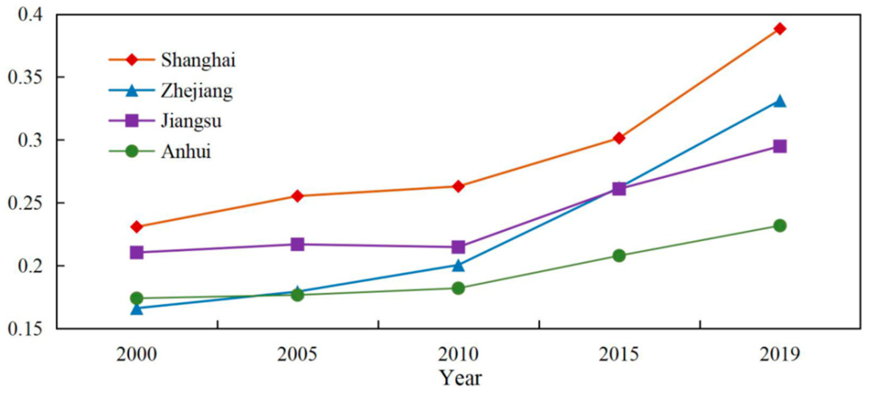
The Yangtze River Delta region consists of four regions: Zhejiang, Jiangsu, Anhui and Shanghai. After calculating the RRI of all counties from 2000 to 2019, the average RRI for each time period in the four regions can be calculated accordingly. Figure 3 demonstrates that the average RRI of all regions showed an increasing trend during the study period, and this growth can be separated into two stages, namely, a slow growth stage (from 2000 to 2010) and a sharp growth stage (from 2010 to 2019). During the slow growth stage, the average RRI growth rates in Zhejiang, Jiangsu, Anhui and Shanghai were only 9.87%, 1.02%, 2.27%, and 6.75%, respectively. Meanwhile, during the rapid growth stage, the average RRI growth rates of the above four regions was as high as 28.54%, 17.20%, 12.86%, and 21.52%.
In the early 21st century, Shanghai had the highest average RRI, followed by Jiangsu, Anhui and Zhejiang. From 2000 to 2010, as a result of benefiting from rapid economic development, the resilience level of Zhejiang improved significantly. Therefore, by 2005, the average RRI of Zhejiang was slightly higher than that of Anhui. And by 2010, the average RRI of Zhejiang was close to that of Jiangsu, ranking second. Around 2010, the Yangtze River Delta region took the lead in transforming its economy from an extensive development model to a high-quality and intensive one. As a result, from 2010 to 2019, the resilience of the four regions increased rapidly. Among them, Zhejiang led the whole Yangtze River Delta region, with the growth rate of 28.54%. It surpassed Jiangsu in 2015 and was second only to Shanghai. In contrast, the rural resilience of Jiangsu and Anhui continued to steadily improve during this period. Although their growth rates were significantly lower than that of Zhejiang and Shanghai, this still indicated good momentum of development in these two provinces.
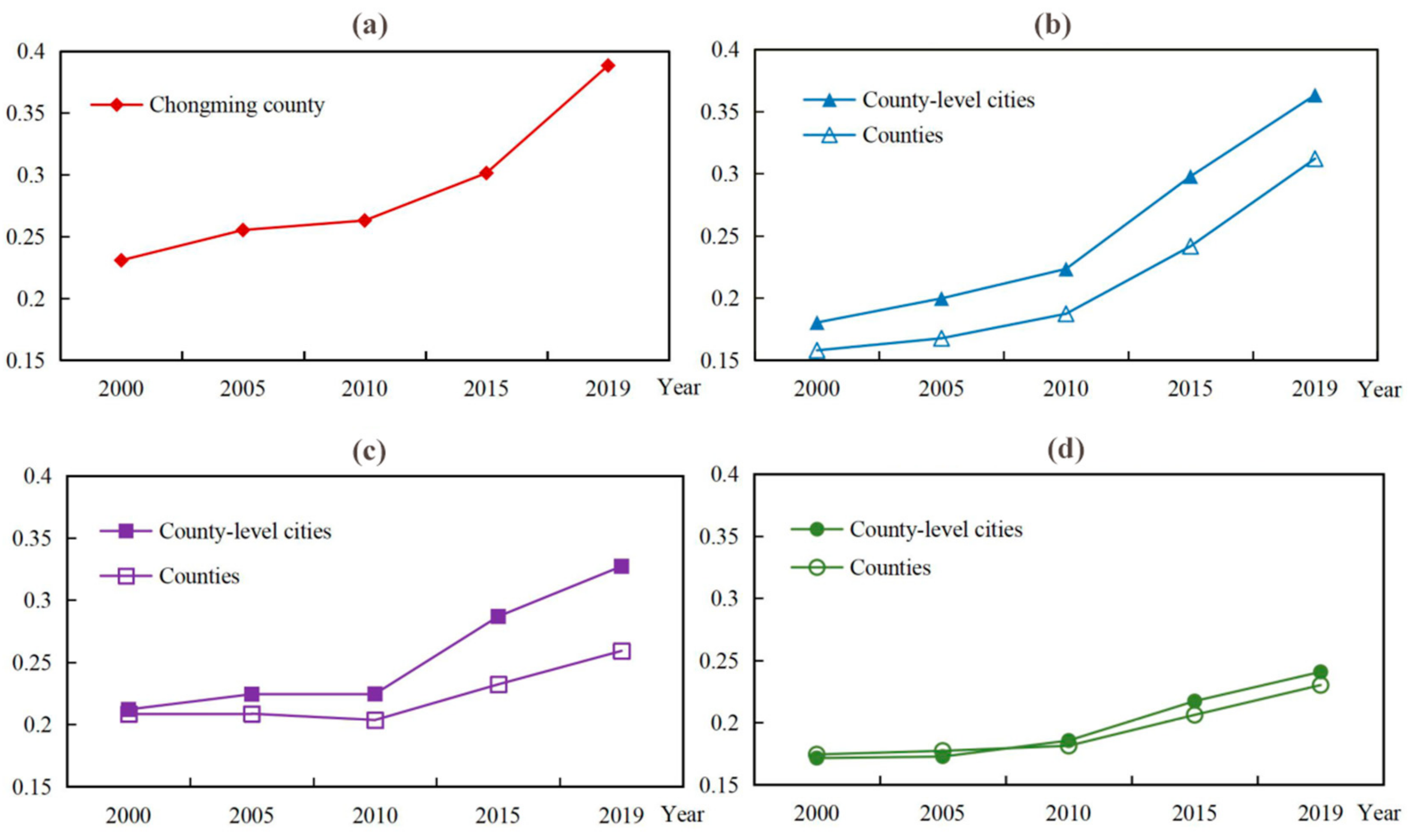
Figure 4 shows the trend in the variation of the average RRI of counties and county-level cities. It can be seen that the average RRI of county-level cities was higher than that of counties during the same period, indicating that county-level cities usually have better rural resilience than counties. This is understandable because county-level cities evolved from well-developed counties. That is, in the movement that emerged in the 1980s and which saw the removal of counties and the setting up of cities, counties that had reached a certain level of economic development were usually upgraded to county-level cities. So, these county-level cities already had a better development foundation than counties. In addition, this movement gave county governments greater administrative autonomy, which further contributed improvements in rural resilience.

3.1.2. The Spatial Evolution of RRI

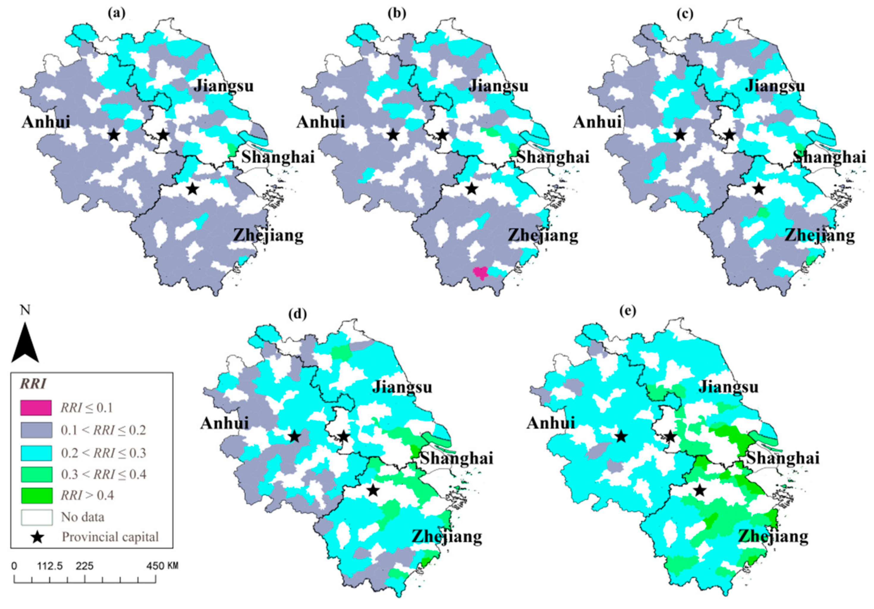
The rural resilience index (RRI) is divided into five levels: low resilience (RRI ≤ 0.1), medium-low resilience (0.1 < RRI ≤ 0.2), medium resilience (0.2 < RRI ≤ 0.3), medium-high resilience (0.3 < RRI ≤ 0.4) and high resilience (RRI > 0.4). These levels are denoted by symbols the L, ML, M, MH and H, respectively. ArcGIS 10.5 was used to visualize the results based on the above classification. Figure 5 shows in visual terms how rural resilience in the Yangtze River Delta region has significant spatial differences. Spatially, the rural resilience in the Yangtze River Delta region is higher in the east and lower in the west. The regions with high rural resilience are concentrated in southern Jiangsu and northern Zhejiang, while the whole of Anhui and southern Zhejiang are low in rural resilience.

3.2. The Spatial Correlation Pattern of Rural Resilience

3.2.1. The Results of Global Spatial Autocorrelation Analysis

As can be seen from Table 2, Moran’s I is above 0.5 in 2000, 2005, 2015 and 2019 (Moran’s I is only slightly under 0.5 in 2010), and the above results all passed the significance test. In general, Moran’s I showed a trend of decreasing first and then increasing.
This process of change with regard to Moran’s I shows that at the early stage of the study period, when the Yangtze River Delta region was affected by its geographical location, policy, history and other factors, its development was unbalanced, which meant that the rural resilience of the whole region had obvious spatial agglomeration characteristics. As time went by, during the decade from 2000 to 2010, the underdeveloped regions seized their development opportunities and began to catch up, making the coordination of the whole region stronger and the agglomeration of rural resilience weaker. However, from 2010 to 2019, the Matthew effect of regional development appeared again, as financial capital began to concentrate in the most developed cities or towns. This made the spatial agglomeration of rural resilience become stronger again, with it reaching its strongest level in 2019. At this time, the polarization of rural resilience in the Yangtze River Delta region was quite obvious, and the most developed cities or towns played a significant driving role in improving rural resilience.

3.2.2. The Results of Local Spatial Autocorrelation Analysis

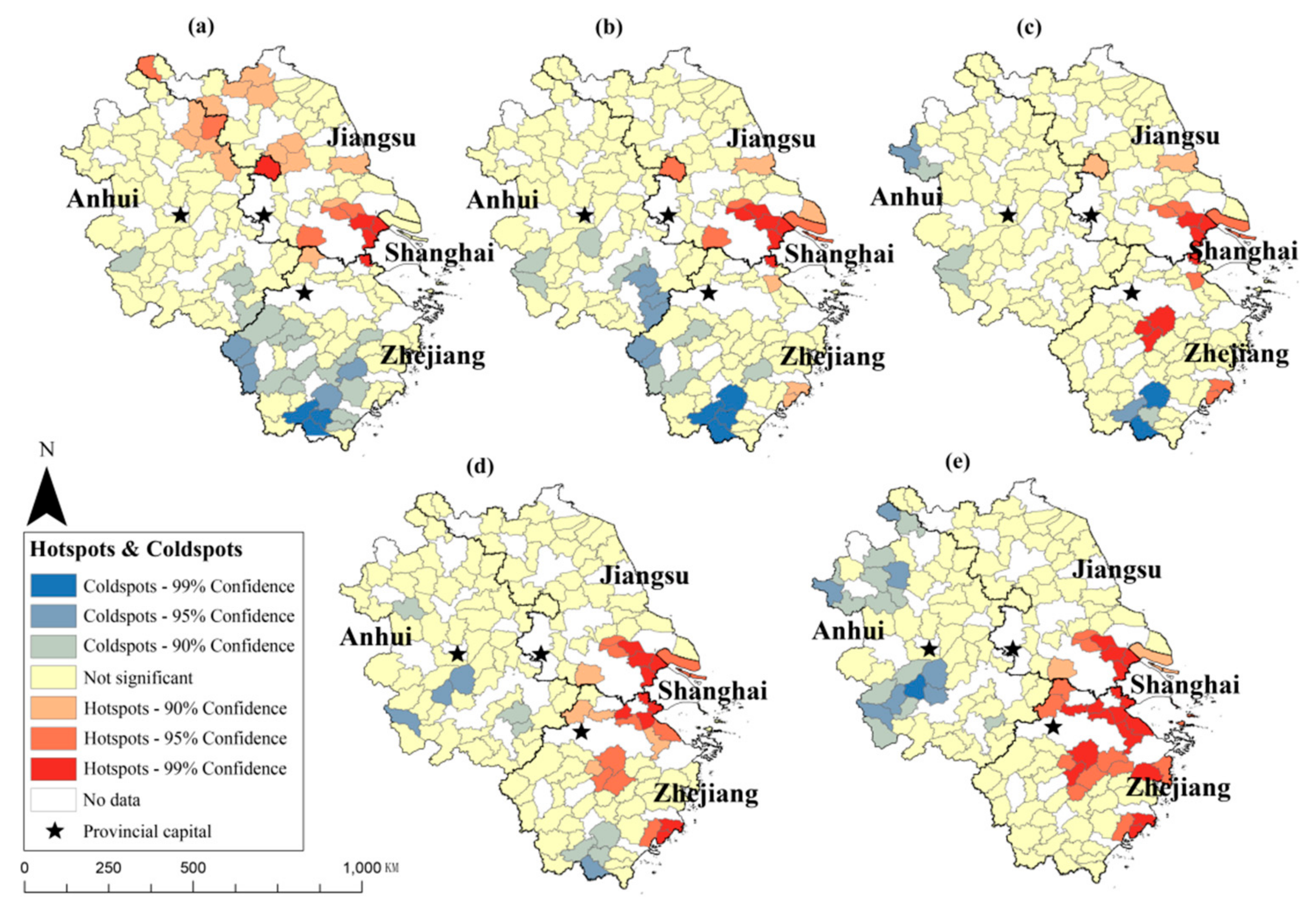
Similarly, the Getis-Ord G i * index of each research unit in 2000, 2005, 2010, 2015 and 2019 was calculated by using ArcGIS 10.5, and these research units were classified as hotspots, coldspots and not significant spots (that is, neither coldspot nor hotspot). Among them, the hotspots were further divided into primary hotspots (with 99% confidence), secondary hotspots (with 95% confidence) and tertiary hotspots (with 90% confidence), and the coldspots were also divided into primary coldspots (with 99% confidence), secondary coldspots (with 95% confidence) and tertiary coldspots (with 90% confidence), according to the same classification. In other words, according to Getis-Ord G i * index, these research units were divided into seven types, forming the local correlation pattern of rural resilience in the Yangtze River Delta region, as shown in Figure 6. This figure also shows that coldspots and hotspots have obvious continuity in spatial distribution.
In terms of the spatial distribution of the hotspots, from 2000 to 2019, the hotspots area gradually shifted from Jiangsu to Zhejiang in general. At first, in 2000, the hotspots were evenly distributed in Jiangsu. Later, as the developmental speed of southern Jiangsu was much faster than that of north Jiangsu and central Jiangsu, the hotspots began to concentrate in this region. After 2010, the strong rise of Zhejiang led to the emergence of a large number of hotspots in the most developed areas of northern and central Zhejiang. In the meantime, southern Jiangsu, where hotspots were found previously, maintained its former status.
As for the coldspots, from 2000 to 2019, the coldspot areas gradually shifted from Zhejiang to Anhui. At the beginning of the study period, most of the coldspots were distributed in Zhejiang. Later, while Zhejiang grasped development opportunities in the new century, Anhui lagged far behind. As a result, the coldspot areas in Zhejiang gradually shrank, and the coldspot areas began to expand in Anhui. Finally, the coldspots were only concentrated in the south and northwest of Anhui.

3.3. Clustering Results

3.3.1. Five Types of Rural Development

K-means clustering analysis was carried out using SPSS 24, and the number of clusters was determined to be five by the Elbow Method. In addition, the results of ANOVA (Table 3) indicate that all five types of capital contributed significantly to the clustering (Sig. < 0.001).
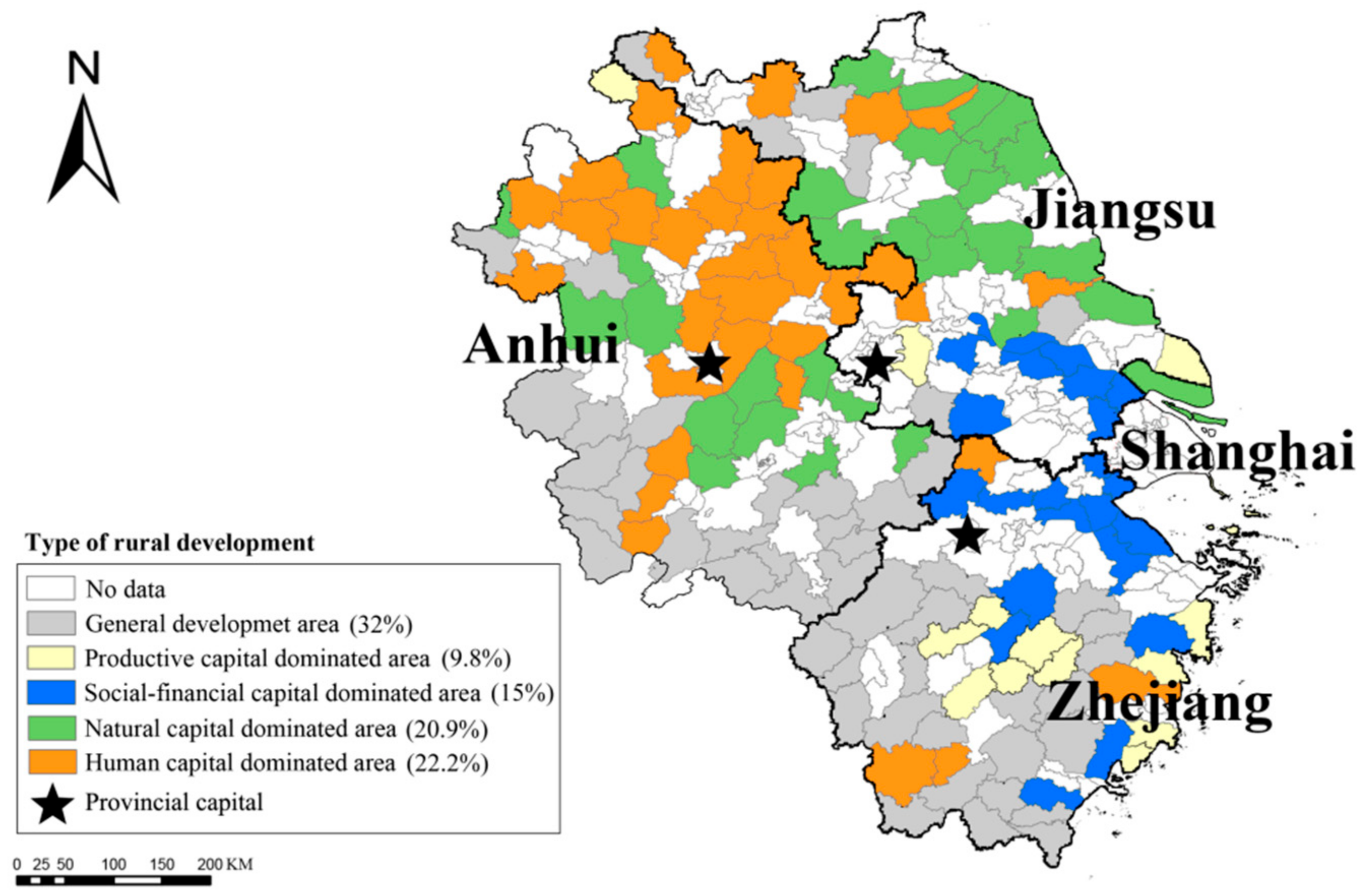
Table 4 shows the centers of each cluster in the five capital dimensions. Furthermore, the 153 research units could be categorized in terms of natural capital-dominated areas (U4), productive capital-dominated areas (U1), human capital-dominated areas (U5), social-financial capital-dominated areas (U3) and general development areas (U2). Finally, this was visualized as a map (Figure 7).

3.3.2. General Characteristics of Each Type of Rural Area

Table 5 shows the general characteristics of each cluster. Using this table, in preparation for the subsequent resilience promotion strategies, the advantages and disadvantages of various rural areas could be summarized.
Productive capital-dominated areas (U1) have superior agricultural modernization levels, and the proportion of facility agriculture (C22) in these areas is often the highest in the whole region, which reflects the emphasis on controlling the agricultural environment. However, the level of agricultural mechanization (C21) in such areas, while not low, is still not as high as that in social-financial capital-dominated areas, so there is a lot of room for improvement.
The characteristics of general development areas (U2) are not obvious. It should be noted that, compared with the beginning of the study period, this type of area improved significantly in terms of medical facilities (A12) and social welfare (A13) at the end of the study. However, at the same time, the level of agricultural mechanization in such areas is very weak (A21), which can be one of the focal points of industrial adjustment in the future.
Due to their economic prosperity and open society, the social-financial capital-dominated areas (U3) rank among the best in the whole region in many aspects. They have excellent agricultural mechanization levels (C21), high employment rates (C41), convenient social communication (C42) and efficient government administration (A11, A12, A13). However, the natural resource reserve (C11, C12) in such areas is small, so, while developing the economy, attention should be paid to ecological protection in order to maintain its rurality.
Natural capital-dominated areas (U4) are characterized by good natural resource endowments, which is reflected in sufficient cultivated land (C11) and forest land (C12). Unfortunately, agricultural production in such areas has not been modernized, which is reflected in the low level of mechanization (C21) and the small proportion of facility agriculture (C22). As a result, the profound potential of its natural resources cannot be brought into full play, which ultimately affects regional development.
As the name implies, human capital-dominated areas (U5) are extremely dependent on their human capital. Unfortunately, the level of basic education (C31) and vocational education (C32) in these areas are not outstanding, hindering the improvement of resilience and weakening the power of rural development. At the same time, the government effectiveness (A11, A12, A13) of such areas is also not ideal.

3.3.3. Resilience Promotion Strategy

Productive capital dominated areas (U1) only cover 9.8% of the Yangtze River Delta region and are mainly concentrated in the central region of Zhejiang. In these areas, productive capital is the main factor affecting rural resilience, indicating a high level of agricultural mechanization due to adequate investment in capital and equipment. Compared with natural capital-dominated areas, which are highly dependent on natural conditions, agricultural development in productive capital-dominated areas is more stable and the livelihood of their residents is more guaranteed. Thus, further investment in agricultural production, the improvement of the agricultural infrastructure and the extension of the modern agricultural industry chain can enhance the resilience of rural areas and contribute to the ultimate goal of high-quality development.
General development areas (U2) cover 32% of the whole region and are the most common type of rural development. They are mainly distributed in the southwest of the Yangtze River Delta region, that is, southern Anhui and central and southern Zhejiang. Differing from the above four rural types, general development areas do not have any significant leading factor affecting their rural resilience. However, this does not mean that any measure is ineffective in improving the rural resilience of these areas. On the contrary, this type of area has the typical characteristics of the less developed rural regions in the Yangtze River Delta region. Therefore, the key to improving resilience in these areas is to pay attention to local characteristics. For instance, to develop diversified rural characteristic industries and even build rural characteristic industry clusters, thus achieving the purpose of revitalizing the rural economy.
Social-financial capital-dominated areas (U3) cover 15% of the Yangtze River Delta region, which is mainly composed of county-level cities. These areas are mostly distributed in southern Jiangsu and northern Zhejiang, but also in other developed areas of Zhejiang Province. As the name implies, social capital and financial capital are the two main factors affecting rural resilience in this type of area, suggesting that the rural governance system is mature and that the rural economy is highly market-oriented. Therefore, for such areas, it is necessary to improve rural resilience from both a social and financial point of view, that is, to improve the social governance system and financial service system so as to optimize the social exchange atmosphere and stimulate the vitality of the rural market, thus achieving rural revitalization.
Natural capital-dominated areas (U4) cover 20.9% of the Yangtze River Delta region and are mainly composed of counties rather than county-level cities. In such areas, natural capital is the most important factor affecting rural resilience. In terms of geographical distribution (Figure 7), they are mainly distributed in Anhui and northern Jiangsu, which happen to be the less developed areas in the Yangtze River Delta region. The urbanization process in this type of area is also relatively slow, with weak infrastructures such as transportation, electricity and water conservancy. In addition, the rural development of this type of area is dominated by agriculture, However, due to economic constraints, the agricultural modernization process stagnates. So, agricultural development is largely restricted by natural conditions, resulting in a low efficiency in terms of production and operation. In short, under the joint influence of geographical location, natural conditions and economic foundations, rural resilience in these areas is determined by the power of nature. Therefore, maintaining rural ecological resources and developing the rural ecological economy are effective means of resilience promotion.
Human capital-dominated areas (U5) account for 22.2% of the Yangtze River Delta region, and are mainly distributed in Anhui, with them also being scattered in northern Jiangsu and southern Zhejiang. In this type of area, human capital is the most critical factor affecting rural resilience, indicating that human resources are the main driving force behind sustainable rural development. In human capital dominated areas, rural modernization is extremely dependent on human capital. Once human capital cannot meet the needs of rural development, the improvement of rural resilience in this type of area will also be hindered. For example, during the study period, the population outflow in Anhui was serious, which made the improvement of rural resilience relatively slow and made Anhui gradually become the coldspot of rural resilience. For such areas, training a large number of skilled rural individuals through various means of education such as basic education, vocational education, higher education and adult education can effectively improve the quality of human capital and, in turn, enhance rural resilience.

4. Discussion

Based on the comprehensive evaluation of rural resilience in the Yangtze River Delta region, the level of rural resilience from 2000–2019 undergoes a process from a low level of homogeneous development to a high level of heterogeneous development and then to a higher level of homogeneous development. This means that in the beginning, the rural resilience of the Yangtze River Delta region was generally low, and then some regions began to develop, which not only freed those regions from the state of low resilience, but also drove other areas to achieve high resilience [54]. Temporally, rural resilience in this region has been increasing year by year with increasing speed. This growth in resilience can be divided into two phases, a slow growth stage (from 2000 to 2010) and a sharp growth stage (from 2010 to 2019). This is because at around 2010, the Yangtze River Delta region took the lead in transforming its economy from an extensive development model to a high-quality and intensive one [55]. Thus, it broke through the original low efficiency of the development model. Spatially, the level of rural resilience is higher in the east and lower in the west, that is, the areas with higher rural resilience are concentrated in southern Jiangsu and northern Zhejiang, while the areas with lower resilience are located in southern Zhejiang and the whole of Anhui. First, from the perspective of natural resources, both southern Jiangsu and northern Zhejiang have good hydrogeological conditions, which provide a prerequisite for the healthy development of their primary industry [56]. Second, Nanjing and Hangzhou, as the capitals of Jiangsu and Zhejiang, were both the historical national capital cities. Therefore, driven by this historical status, southern Jiangsu and northern Zhejiang have prospered since ancient times [57], and the population densities of these two regions are also much higher than that of other regions in the Yangtze River Delta region, contributing to their higher resilience. Finally, as for location conditions, both southern Jiangsu and northern Zhejiang are influenced by the economy of Shanghai [58], the largest economic center city in China, and have good shipping or land transportation conditions, which are conducive to their industrial development. However, at the same time, the mountainous terrain of southern Zhejiang has caused a congenital shortage of traffic in this region [59]. In addition, the economic situation of Anhui has been poor, resulting in serious population losses since the reform and opening up [60]. These factors make the developmental power of southern Zhejiang and Anhui relatively insufficient, which has an adverse effect on the promotion of resilience.
According to the spatial correlation pattern of rural resilience in the Yangtze River Delta, the spatial agglomeration characteristics and the distribution of hotspots and coldspots are always changing. At the beginning of the study period, affected by geographical location, policy, history and other factors, the development of the Yangtze River Delta region was unbalanced [61], which meant that the rural resilience of the whole region demonstrated obvious spatial agglomeration. As time went by, during the decade from 2000 to 2010, some underdeveloped regions began to catch up, making the agglomeration of rural resilience weaker. However, from 2010 to 2019, as financial capital began to concentrate in the most developed cities or towns, the Matthew effect of regional development appeared again [62], and the spatial agglomeration of rural resilience reach its strongest level in 2019. The distribution of hotspots and coldspots of rural resilience has obvious continuity. In terms of the hotspots, as Zhejiang grasped the developmental opportunity in the new century [63], from 2000 to 2019, in general terms, the hotspots gradually shifted from Jiangsu to Zhejiang. But in this period, southern Jiangsu, the old hotspots area, still held onto its former status. In terms of coldspots, due to the lack of obvious development advantages [64], the coldspots gradually shifted from Zhejiang to Anhui. And at the end of the study period, the coldspots were only concentrated in the south and northwest of Anhui Province.
Through the use of the elbow method, the number of clusters could be determined to be five, and 153 research units were divided into natural capital-dominated areas (20.9%), productive capital-dominated areas (9.8%), human capital-dominated areas (22.2%), social-financial capital-dominated areas (15%) and general development areas (32%) based on the final clustering centers. The natural capital-dominated areas are mainly distributed in Anhui and northern Jiangsu. Rural resilience in these areas is controlled by the power of nature [65]. Therefore, maintaining rural ecological resources and developing the rural ecological economy are effective means for promoting resilience [66]. The productive capital-dominated areas are mainly concentrated in the central part of Zhejiang Province. To enhance rural resilience in these areas, measures such as further investment in agricultural production, the improvement of agricultural infrastructure and the extension of the modern agricultural industry chain need to be implemented [67]. The human capital-dominated areas are mainly distributed in Anhui. For this type of area, training a large number of skilled rural workers through various means of education can effectively enhance rural resilience [68]. The social-financial capital-dominated areas are mostly distributed in the most developed region of the Yangtze River Delta region. For this type of area, it is necessary to improve the social governance system and financial service system in order to optimize the social exchange atmosphere and stimulate the vitality of the rural market [69], thus achieving rural revitalization. The general development areas, which have the typical characteristics of the less developed rural regions, are mainly distributed in the southwest of the Yangtze River Delta region. Therefore, the key to improving resilience in these areas is to pay attention to local characteristics, such as developing diversified rural characteristic industries and building rural characteristic industry clusters [70].
Compared with previous studies on rural resilience, this study has two advantages. Firstly, from the perspective of research content, it makes up for the lack of macro-scale measurements of rural resilience and the evolution of spatial and temporal patterns. Secondly, from the perspective of differentiation strategy, the clustering algorithm was used to objectively and accurately propose highly targeted zoning optimization suggestions. However, there are some deficiencies in this study, as follows:
(1)
Considering the workload, this paper only selects 153 counties (including county-level cities) in the Yangtze River Delta region as research units. But in fact, the geographical scope of the study area at different times should be completely different. Although these 153 research units are typical to some extent, they cannot accurately represent the overall developmental state of rural areas in the whole region. Therefore, in future studies, scholars need to consider the differences in the study area at different times, so as to more accurately assess the regional rural resilience in different years.
(2)
The rationality of the evaluation index system needs further consideration. Firstly, objective indicators are only used to construct an index system of rural resilience, but subjective evaluation methods are not taken into account. Therefore, anthropological methods such as interviews and field investigations could be used in future research [71]. Secondly, the regional characteristics of the evaluation index system are insufficient. Future studies can highlight the uniqueness of the rural areas in the Yangtze River Delta region in terms of physical geography, hydrological and climatic environment and stages of social development.
(3)
Due to the limitation of time, this study only adopted a geographical research method from a macro perspective, and did not include planning and design, built environment and hardware facilities in the research scope [72,73]. Given this, future research could be combined with plan-level research methods to enhance the specificity and operability of the research conclusions.

5. Conclusions

This study measured the rural resilience of 153 research units in the Yangtze River Delta region from 2000–2019 using the weighted TOPSIS method. The results of this comprehensive evaluation of rural resilience in the Yangtze River Delta region show significant differences in temporal and spatial dimensions, with an overall state of improvement. The spatial agglomeration of rural resilience tends to move from strong to weak and becomes stronger over time. In addition, there is a significant continuity in the spatial distribution of hotspots and coldspots in terms of rural resilience. The hotspots gradually shift from Jiangsu to Zhejiang, while the coldspots shift from Zhejiang to Anhui. In the five clusters of natural capital dominated areas, productive capital dominated areas, human capital dominated areas, social-financial capital dominated areas and general development areas, the performance of each cluster on the five capital dimensions also provides a basis for the subsequent targeted enhancement of rural resilience.

Author Contributions

F.S. and J.L.: investigation, software, data curation; F.S., J.L. and L.T.: conceptualization, methodology; J.L., H.L. and Y.L.: writing—original draft preparation; F.S., J.L., H.L. and Y.L.: writing—review and editing, validation; F.S. and L.T.: supervision, project administration, funding acquisition. All authors have read and agreed to the published version of the manuscript.

Funding

This research was funded by the National Natural Science Foundation of China, grant number 42071159, 51908498, 41901202.

Institutional Review Board Statement

Not applicable.

Data Availability Statement

The data presented in this study are available on request from the corresponding author at ([email protected]).

Conflicts of Interest

The authors declared no conflict of interest.

References

  1. Martin, R. Regional economic resilience, hysteresis and recessionary shocks. J. Econ. Geogr. 2012, 12, 1–32. [Google Scholar] [CrossRef]
  2. Ahmed, S. Collaborative resilience: Moving through crisis to opportunity. Community Dev. 2013, 44, 395–397. [Google Scholar] [CrossRef]
  3. McManus, P.; Walmsley, J.; Argent, N.; Baum, S.; Bourke, L.; Martin, J.; Pritchard, B.; Sorensen, T. Rural community and rural resilience: What is important to farmers in keeping their country towns alive. J. Rural. Stud. 2012, 28, 20–29. [Google Scholar] [CrossRef]
  4. Meng, G.; Gebhardt, H. Rural Development and Transformation in the Federal Republic of Germany since the 1950s. Acta Geogr. Sin. 2011, 66, 1644–1656. [Google Scholar]
  5. Zhao, W. 1950–2010: The Overview of Rural Development and Planning Strategy in Post-War Europe. Dev. Small Cities Towns 2019, 37, 5–11. [Google Scholar]
  6. Yang, X. The Exploration of Values in the Rural Revitalization in Japan: A Case Study of Noto’s Satoyama and Satoumi. Urban Plan. Int. 2016, 31, 115–120. [Google Scholar] [CrossRef] [Green Version]
  7. Li, Q.; Zander, P. Resilience building of rural livelihoods in PES programmes: A case study in China’s Loess Hills. Ambio 2020, 49, 962–985. [Google Scholar] [CrossRef]
  8. Wilson, G.A.; Hu, Z.; Rahman, S. Community resilience in rural China: The case of Hu Village, Sichuan Province. J. Rural. Stud. 2018, 60, 130–140. [Google Scholar] [CrossRef] [Green Version]
  9. Cutter, S.L.; Ash, K.D.; Emrich, C.T. Urban-rural differences in disaster resilience. Ann. Am. Assoc. Geogr. 2016, 106, 1236–1252. [Google Scholar] [CrossRef]
  10. Freshwater, D. Vulnerability and resilience: Two dimensions of rurality. Sociol. Rural. 2015, 55, 497–515. [Google Scholar] [CrossRef] [Green Version]
  11. Tolossa, D. Rural Livelihoods, Poverty and Food Insecurity in Ethiopia. Ph.D. Thesis, Norwegian University of Science and Technology, Trondheim, Norway, 2005. [Google Scholar]
  12. Yuan, J. Essays on New Village Architecture in Hong Kong. Archit. J. 1987, 6, 50–56. [Google Scholar]
  13. Zhang, J. Prospects for coordinated development of urban and rural communities. Truth Seek. 2006, S2, 192–193. [Google Scholar]
  14. Wang, X.; Zhang, Q. Rural settlements and economical land use. Jiangsu Economic News, 19 January 2006; p. A01. [Google Scholar]
  15. Wang, H.; Xu, Y.; Lu, S.; Ren, Y.; Xiang, W. A Comparative Study of Chinese Translation of Resilience Terminology in Socio-Ecological System and Its Related Research Fields. Urban Plan. Int. 2017, 32, 29–39. [Google Scholar] [CrossRef] [Green Version]
  16. Zautra, A.; Hall, J.; Murray, K. Community development and community resilience: An integrative approach. Community Dev. 2008, 39, 130–147. [Google Scholar] [CrossRef]
  17. Maguire, B.; Hagan, P. Disasters and communities: Understanding social resilience. Aust. J. Emerg. Manag. 2007, 22, 16–20. [Google Scholar]
  18. Kelly, C.; Ferrara, A.; Wilson, G.A.; Ripullone, F.; Nolè, A.; Harmer, N.; Salvati, L. Community resilience and land degradation in forest and shrubland socio-ecological systems: Evidence from Gorgoglione, Basilicata, Italy. Land Use Policy 2015, 46, 11–20. [Google Scholar] [CrossRef] [Green Version]
  19. Li, T. New Progress in Study on Resilience Cities. Urban Plan. Int. 2017, 32, 15–25. [Google Scholar] [CrossRef]
  20. Cai, J.; Guo, H.; Wang, D. Review on the Resilience City Research Overseas. Prog. Geogr. 2012, 31, 1245–1255. [Google Scholar]
  21. Rudiarto, I.; Handayani, W.; Wijaya, H.B.; Insani, T.D. Rural livelihood resilience: An assessment of social, economic, environment, and physical dimensions. In Proceedings of the 5th International Conference on Sustainable Built Environment (ICSBE 2018), Banjarmasin, Indonesia, 11–13 October 2018; pp. 1–12. [Google Scholar]
  22. Wang, T. Research on the Resilience of Rural Development under the Background of Modernization. Master’s Thesis, Zhejiang Normal University, Jinhua, China, 2019. [Google Scholar]
  23. Li, H. Rural Settlements Research from the Perspective of Resilience Theory. Sci. Geogr. Sin. 2020, 40, 556–562. [Google Scholar]
  24. Rose, A. Defining and measuring economic resilience to disasters. Disaster Prev. Manag. 2004, 13, 307–314. [Google Scholar] [CrossRef]
  25. Heijman, W.; Hagelaar, G.; Heide, M. Rural Resilience as a New Development Concept. In EU Bioeconomy Economics and Policies: Volume II. Palgrave Advances in Bioeconomy: Economics and Policies; Dries, L., Heijman, W., Jongeneel, R., Purnhagen, K., Wesseler, J., Eds.; Palgrave Macmillan: Cham, Switzerland, 2019; pp. 195–211. [Google Scholar]
  26. Colding, J. ‘Ecological land-use complementation’ for building resilience in urban ecosystems. Landsc. Urban Plan. 2007, 81, 46–55. [Google Scholar] [CrossRef]
  27. Zhao, R.; Fang, C.; Liu, H. Progress and propect of Urban resilience research. Prog. Geogr. 2020, 39, 1717–1731. [Google Scholar] [CrossRef]
  28. Li, Y.; Chen, W.; Sun, Y. New reflections on the analysis of regional resilience in geographical sciences from a relational-dynamic perspective. Geogr. Res. 2019, 38, 1694–1704. [Google Scholar]
  29. Young, R.C.; MacCannell, D. Predicting the quality of life in the United States. Soc. Indic. Res. 1979, 6, 23–40. [Google Scholar] [CrossRef]
  30. Cox, R.S.; Hamlen, M. Community disaster resilience and the rural resilience index. Am. Behav. Sci. 2015, 59, 220–237. [Google Scholar] [CrossRef]
  31. Jurjonas, M.D. A Framework for Rural Coastal Community Resilience: Assessing Diverse Perceptions of Adaptive Capacity for Climate Change. Ph.D. Thesis, North Carolina State University, Raleigh, NC, USA, 2018. [Google Scholar]
  32. Khatibi, S.A.; Golkarian, A.; Mosaedi, A.; Hamdollah, S.Q. Assessment of resilience to drought of rural communities in Iran. J. Soc. Serv. Res. 2019, 45, 151–165. [Google Scholar] [CrossRef]
  33. Tang, D.; Mao, M.; Shi, J.; Hua, W. The Spatio-Temporal Analysis of Urban-Rural Coordinated Development and Its Driving Forces in Yangtze River Delta. Land 2021, 10, 495. [Google Scholar] [CrossRef]
  34. Zhao, W.; Liu, X.; Deng, Q.; Li, D.; Xu, J.; Li, M.; Cui, Y. Spatial Association of Urbanization in the Yangtze River Delta, China. Int. J. Environ. Res. Public Health 2020, 17, 7276. [Google Scholar] [CrossRef]
  35. Xu, W.; Ming, X.; Ma, Y.; Zhang, X.; Shi, P.; Zhuo, L.; Lu, B. Quantitative Multi-Hazard Risk Assessment of Crop Loss in the Yangtze River Delta Region of China. Sustainability 2019, 11, 922. [Google Scholar] [CrossRef] [Green Version]
  36. Wu, H.; Huang, A.; Huang, X. Variation Characteristics of Seasons in the Yangtze River Delta during the Past 50 Years. Chin. J. Agrometeorol. 2012, 33, 317–324. [Google Scholar]
  37. Yue, L. Research on the Development Mode of Yangtze River Delta Region under the Background of Urban-Rural Integration. Urban Transp. Constr. 2021, 7, 32–35. [Google Scholar]
  38. Yue, L.; Xu, K.; Shi, G. Property Analysis and Method Selection of the Indexes Being Dimensionless. J. Stat. Inf. 2020, 35, 3–9. [Google Scholar]
  39. Yan, J. Study on the Rural Territorial System Differentiation and Its Regulation in Beijing-Tianjin-Hebei Region. Master’s Thesis, University of Chinese Academy of Sciences, Beijing, China, 2020. [Google Scholar]
  40. Gebrekidan, G.G. Resilience of Rural Households to Food Insecurity in Ahferom Wereda, Central Zone of Tigray National Regional State, Ethiopia. Ph.D. Thesis, Addis Ababa University, Addis Ababa, Ethiopia, 2019. [Google Scholar]
  41. Zhang, C.; Jiang, Z.; Han, B.; Tan, D. Review on natural capital valuation. Acta Ecol. Sin. 2021, 41, 9174–9185. [Google Scholar] [CrossRef]
  42. Ge, D.; Yu, S.; Liu, B. Research on Social, Production Capital and the New-Types Farmers’Willingness to Professional Train. J. Xinyang Agric. For. Univ. 2021, 31, 40–45. [Google Scholar]
  43. Liu, R. Study on the Influence of Rural Human Capital on Agricultural Economic Growth in Heilongjiang Province. Master’s Thesis, Heilongjiang Bayi Agricultural University, Daqing, China, 2021. [Google Scholar]
  44. Bian, Y. Source and Functions of Urbanites’ Social Capital: A Network Approach. Soc. Sci. China 2004, 3, 137–145. [Google Scholar]
  45. Guo, L. Characteristics, problems and operational risks of rural social governance system in developed areas: A case study of rural areas in Yangtze River Delta region. Huxiang Forum 2021, 34, 37–46. [Google Scholar]
  46. Zhang, H.; Li, X. Dicussion on the livelihood framework design of returning fishermen from the perspective of sustainable livelihood theory. Chin. Fish. Econ. 2022, 40, 102–110. [Google Scholar]
  47. Krantz, L. The Sustainable Livelihood Approach to Poverty Reduction; Swedish International Development Cooperation Agency: Stockholm, Sweden, 2001; pp. 1–27. [Google Scholar]
  48. Javed, A.M.; Bill, P. Financial capital as a shaper of households’ adaptive capabilities to flood risk in northern Bangladesh. Ecol. Econ. 2022, 195, 107381. [Google Scholar]
  49. Huang, Y. Research on Local Government Effectiveness Evaluation. Master’s Thesis, Nanjing Normal University, Nanjing, China, 2021. [Google Scholar]
  50. Yang, Y. Evaluation and Analysis of Weight Assignment Method in Multi-index Comprehensive Evaluation. Stat. Decis. 2006, 13, 17–19. [Google Scholar]
  51. Hwang, C.L.; Yoon, K.S. Multiple Attribute Decision Making; Springer: Berlin/Heidelberg, Germany, 1981. [Google Scholar]
  52. Li, Z.; Wang, R.; Shen, X. Cultivated Land Protection Zoning Based on Quality Index and Spatial Autocorrelation. Chin. J. Soil Sci. 2021, 52, 785–792. [Google Scholar]
  53. Wu, G.; Zhang, J.; Yuan, D. Automatically Obtaining K Value Based on K-means Elbow Method. Comput. Eng. Softw. 2019, 40, 167–170. [Google Scholar]
  54. Zhou, L.; Sun, N.; Miao, H. Polarization Effect and Spread Effect: The Role of the Yangtze River Delta in Regional Balanced Development: Evidence from Urban Agglomerations in the Yangtze River Delta and the Middle Reaches of the Yangtze River. Resour. Environ. Yangtze Basin 2021, 30, 782–795. [Google Scholar]
  55. Hou, S.; Zhen, Y.; Cao, X. Evaluation Index System of Urban Agglomeration Governance Under the Background of High-quality Development: A Case of the Yangtze River Delta. Econ. Geogr. 2022, 42, 35–44. [Google Scholar]
  56. Wang, W. Comparative Study on County Economic Development Paths between South Jiangsu and North Zhejiang. J. Commer. Econ. 2012, 15, 137–139. [Google Scholar]
  57. Chen, W. Discussion Once More on the Methodologies Applied in Protect the Historic Cities that a Strong Backbone to Well Proportioned: Two Cases of Protecting Roads Heritages in Historic Cities, Nanjing and Hangzhou. Architect 2013, 5, 85–95. [Google Scholar]
  58. Wu, Y. Research on Financial Agglomeration and Radiation Effects of Urban Groups in the Yangtze River Delta. Ph.D. Thesis, Soochow University, Suzhou, China, 2019. [Google Scholar]
  59. Zhu, G. Analysis of Measures to Promote Rural Economic Development in South Zhejiang Mountainous Area. Rural. Econ. Sci. Technol. 2017, 28, 154–155. [Google Scholar]
  60. Duan, J. Rural Population Flow in Anhui after Reform and Opening up. Agric. Archaeol. 2017, 3, 249–254. [Google Scholar]
  61. Chen, Y. Research on the Influencing Factors and Solutions of Regional Economic Imbalance under the Background of Yangtze River Delta Regional Integration Development. Bus. Econ. 2022, 2, 14–16. [Google Scholar]
  62. Wei, W. Early Warning of ‘Matthew Effect’ of Beijing-Tianjin-Hebei Coordinated Development: Problems, Causes and Suggestions. Soc. Sci. Guangxi 2017, 3, 64–68. [Google Scholar]
  63. Yu, H. Preliminary Study on the Development Experience of Zhejiang Province in 40 Years of Reform and Opening Up. Obs. Ponder. 2019, 4, 98–103. [Google Scholar]
  64. Duan, J. Restrictive Factors and Suggestions of County Economy Development in Anhui Province. Bus. Econ. 2013, 23, 40–41. [Google Scholar]
  65. Lin, X.; Xing, L.; Liu, Z. The Conceptual Basis of Natural Capital. Product. Res. 2020, 12, 16–19. [Google Scholar]
  66. Wang, S.; Cui, Z.; Lin, J.; Xie, J.; Su, K. Coupling Relationship between Urbanization and Ecological Resilience in the Pearl River Delta. Acta Geogr. Sin. 2021, 76, 973–991. [Google Scholar] [CrossRef]
  67. Wang, Y.; Li, Y.; Pan, B. Resilient Development Strategies of Precise Industrial Poverty Alleviation, Henan Province. Planners 2018, 34, 39–45. [Google Scholar]
  68. Pu, S.; Sun, W. Policy Research on the Construction of Rural Talents in the Implementation of Rural Revitalization Strategy. Chin. Public Adm. 2018, 11, 90–93. [Google Scholar]
  69. Wang, S.; Wang, D. Financial Support for the Rural Revitalization Strategy. China Financ. 2018, 4, 69–70. [Google Scholar]
  70. Cui, C. Analysis on the Distinctive Path of the Rural Industry Prosperity. Acad. J. Zhongzhou 2018, 8, 47–52. [Google Scholar]
  71. Xu, X. On Anthropological Methods: Fieldwork, Observation, or Life Introspection. J. Lanzhou Univ. 2016, 44, 84–95. [Google Scholar]
  72. Pan, S.; Ma, C. Evaluation Indicators System for the City Infastructure Development Level. Syst. Eng. 2007, 7, 88–91. [Google Scholar]
  73. Wang, J. The Research onto Quantified Analysis of Urban Spatial Morphology. Master’s Thesis, Chongqing University, Chongqing, China, 2004. [Google Scholar]
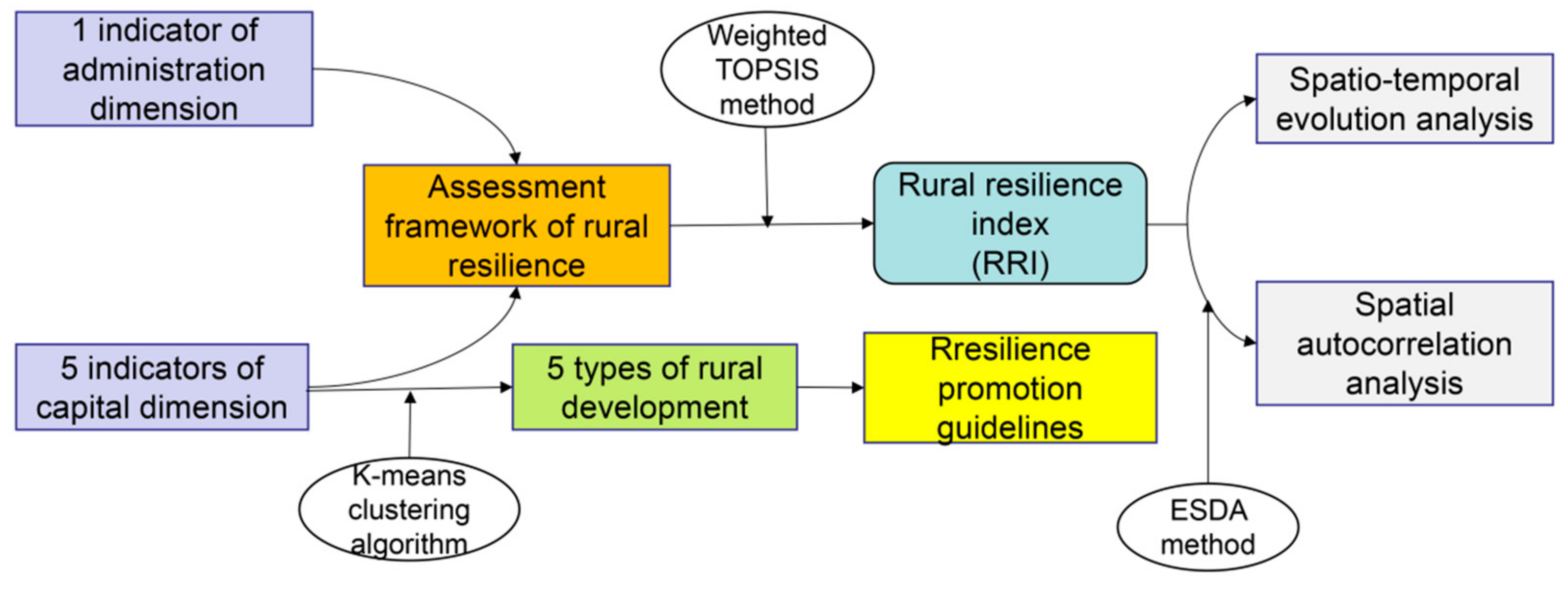
Figure 1. Study scheme.
Sustainability 14 05382 g001
Figure 2. The location of the Yangtze River Delta region and the distribution of 153 research units.
Sustainability 14 05382 g002
Figure 3. The average RRI of the four regions in the Yangtze River Delta region.
Sustainability 14 05382 g003
Figure 4. The average RRI of the four regions based on county and county-level city division: (a) The average RRI of Shanghai from 2000–2019; (b) The average RRI of Zhejiang from 2000–2019; (c) The average RRI of Jiangsu from 2000–2019; (d) The average RRI of Anhui from 2000–2019.
Sustainability 14 05382 g004
Figure 5. Rural resilience level of each research unit in the Yangtze River Delta region from 2000–2019: (a) Rural resilience in 2000; (b) Rural resilience in 2005; (c) Rural resilience in 2010; (d) Rural resilience in 2015; (e) Rural resilience in 2019.
Sustainability 14 05382 g005
Figure 6. The coldspots and hotspots of rural resilience in the Yangtze River Delta region from 2000–2019: (a) The coldspots and hotspots of rural resilience in 2000; (b) The coldspots and hotspots of rural resilience in 2005; (c) The coldspots and hotspots of rural resilience in 2010; (d) The coldspots and hotspots of rural resilience in 2015; (e) The coldspots and hotspots of rural resilience in 2019.
Sustainability 14 05382 g006
Figure 7. Classification of rural development types in the Yangtze River Delta region.
Sustainability 14 05382 g007
Table 1. Assessment framework of rural resilience in the Yangtze River Delta region.
DimensionMain FactorMeasured Indicator
CapitalNatural capital
(C1)
Per capita arable land area (C11)
Proportion of new afforestation area (C12)
Productive capital
(C2)
Total power of agricultural machinery per capita (C21)
Proportion of facility agriculture (C22)
Human capital
(C3)
Proportion of primary and middle school students (C31)
Proportion of secondary vocational school students (C32)
Social capital
(C4)
Employment rate (C41)
Fixed-line penetration (C42)
Financial capital
(C5)
Per capita gross regional product (C51)
Per capita disposable income of rural residents (C52)
AdministrationGovernment effectiveness
(A1)
Per capita public expenditure (A11)
Number of beds in medical institutions per 1000 population (A12)
Number of beds in welfare institutions per 1000 population (A13)
Table 2. Global spatial autocorrelation analysis by Moran’s I (2000–2019).
Year20002005201020152019
Moran’s I0.5450.5240.4700.6720.807
Expectations Index−0.007−0.007−0.007−0.007−0.007
Variance0.0060.0060.0060.0060.006
Z-score7.3857.1076.3969.15910.913
p<0.001<0.001<0.001<0.001<0.001
Table 3. Results of ANOVA.
ClusterErrorF-ValueSig.
MSDFMSDF
Natural capital24.13140.37514864.378<0.001
Productive capital23.34440.39614858.931<0.001
Human capital20.28840.47914842.380<0.001
Social capital22.83140.41014855.689<0.001
Financial capital24.40340.36714866.406<0.001
Table 4. Results of K-means algorithm.
Cluster
U1U2U3U4U5
Natural capital−0.833−0.606−0.6731.2180.549
Productive capital2.278−0.1890.188−0.428−0.457
Human capital−0.445−0.2130.369−0.9441.142
Social capital0.328−0.3651.763−0.466−0.372
Financial capital0.457−0.3871.794−0.374−0.505
Table 5. Characteristics of five types of rural areas in the Yangtze River Delta region (2000–2019).
Year Measured Indicator
ClusterC11C12C21C22C31C32C41C42C51C52A11A12A13
2000U10.050.34%13.761.93%14.78%0.91%44.77%58.08%3.202629.350.241.690.89
U20.040.33%12.531.80%14.81%0.92%45.33%58.33%3.162669.110.241.660.89
U30.020.26%24.871.56%13.45%0.96%44.91%78.95%4.923417.000.301.971.11
U40.040.35%12.821.81%14.79%0.93%45.11%57.46%3.092605.680.241.680.85
U50.040.34%13.441.86%14.88%0.93%44.72%56.65%3.072557.260.231.660.86
2005 Measured Indicator
ClusterC11C12C21C22C31C32C41C42C51C52A11A12A13
U10.040.32%19.192.17%13.80%0.91%47.73%63.71%3.204403.150.361.861.54
U20.040.31%17.482.05%13.95%0.92%48.25%63.77%3.164456.570.351.841.56
U30.020.32%35.032.10%12.38%0.96%49.09%75.23%4.925702.890.452.242.23
U40.040.33%17.872.07%15.02%0.86%46.79%57.20%1.883463.840.281.571.03
U50.040.31%18.732.06%13.98%0.92%47.57%62.95%3.074284.220.351.811.48
2010 Measured Indicator
ClusterC11C12C21C22C31C32C41C42C51C52A11A12A13
U10.040.34%9.831.82%11.04%0.88%48.01%60.92%3.207886.740.532.423.62
U20.040.34%9.091.73%11.16%0.88%48.00%61.40%3.167970.650.522.363.62
U30.020.25%17.401.81%10.82%0.93%49.08%73.25%4.9210,183.670.672.623.76
U40.040.35%9.241.71%11.07%0.88%47.89%60.24%3.097804.630.522.393.62
U50.030.34%9.551.71%11.13%0.89%47.72%59.92%3.077687.420.522.373.56
2015 Measured Indicator
ClusterC11C12C21C22C31C32C41C42C51C52A11A12A13
U10.040.36%10.391.96%10.07%0.88%57.21%49.89%5.3115,513.140.803.615.55
U20.040.37%9.651.86%10.19%0.89%57.35%50.14%5.2415,631.590.783.585.61
U30.020.18%18.252.15%10.35%0.92%63.54%66.43%7.8019,877.380.994.156.54
U40.040.38%9.811.84%10.11%0.89%57.00%49.27%5.1515,352.090.793.585.58
U50.030.38%10.041.79%10.08%0.89%56.51%48.29%5.1315,157.200.783.565.45
2019 Measured Indicator
ClusterC11C12C21C22C31C32C41C42C51C52A11A12A13
U10.040.34%11.972.79%10.84%0.87%57.54%40.67%7.4122,229.791.184.456.58
U20.030.35%11.102.71%10.83%0.89%58.68%41.85%7.3522,454.021.154.446.60
U30.020.29%20.883.80%11.22%0.93%65.88%52.59%10.4828,424.771.535.067.95
U40.040.37%11.272.64%10.84%0.89%58.31%41.29%7.2022,083.581.174.426.58
U50.030.34%11.542.41%10.86%0.88%56.92%39.34%7.1721,731.501.154.396.47
Publisher’s Note: MDPI stays neutral with regard to jurisdictional claims in published maps and institutional affiliations.