1. Introduction
As urbanization accelerates, the ecological services (ESs) that ecosystems can provide are gradually becoming more and more homogeneous, and ecological security is under serious threat [
1]. Building ecological security patterns (ESPs) is an important way to maintain the structure and function of ecosystems, ensure ecological security, and balance the relationship between economic and social development and ecological protection [
2,
3,
4].
The traditional methodology of constructing ESPs can be divided into three steps: identifying ecological sources, constructing ecological resistance surface, and determining elements, such as ecological corridors and ecological strategic nodes [
5]. Ecological sources are the basis of ESPs, which can provide multiple ecosystem services. [
6,
7,
8]. Ecosystems provide services to humans through the transmission of ecosystem services and are a prerequisite for ecological security [
9,
10]. Therefore, the ability of a region to provide ecosystem services is one of the basis for identifying ecological sources. There are three main methods that have been applied to assess ESs: the emergy method, InVEST models, and economic methods [
11,
12]. In addition to ecosystem service assessment, ecological risk assessment is also considered to be one of the bases for identifying ecological sources and is often included in the assessment of ecosystem services. Jian Peng et al. used degradation risk assessment and ecological importance assessment as secondary indicators of ecosystem services to identify ecological sources, which ensures that ecological sources identified are of low ecological risk [
13]. However, areas that provide ecosystem services and are at high ecological risk will not be identified as ecological sources, which can lead to potential ecological sources being neglected. Gong et al. were the first to use ecosystem service assessment and landscape risk assessment as two independent indicators and apply them to the zoning and management of ecosystem service functions [
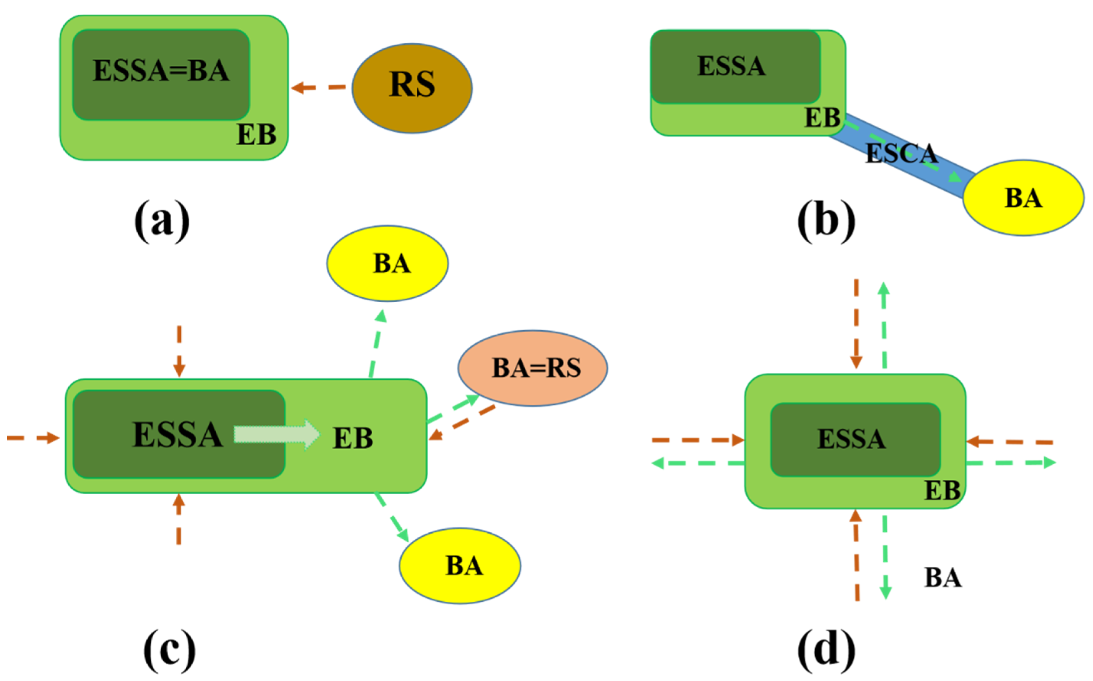
14]. This approach not only identifies ecological functional areas, but also classifies them into risk classes based on risk assessment, providing a scientific basis for regional differentiated ecological management. In the construction of ESPs, the classification of ecological risk levels of ecological sources and the development of adaptive management strategies will contribute to the stability of the structure and function of ESPs. Therefore, assessing the ecological risks of ecological source sites is key to achieving differentiated ecological management in the process of building ecological security patterns.
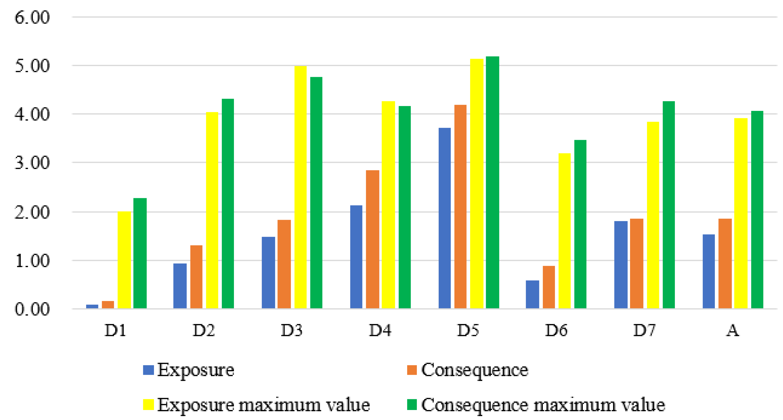
The InVEST Habitat Risk Assessment (HRA) model is used to assess the risk of stressors related to human activities to habitats [
15]. Using the HRA model to evaluate the ecological risk of ecological sources cannot only divide the ecological sources according to the risk, but also make a differential analysis on the risk of ecological sources by using exposure and sensitivity indicators to provide the basis for the adaptive management of ecological sources. HRA takes exposure and sensitivity as the framework to identify the spatial differences of risks by assessing the cumulative risks of multiple human activities to the region [
16,
17]. The HRA model flexibly incorporates the original literature and expert opinions and has been applied to the division of habitat, the risk analysis of human activities on habitat, and the analysis of landscape connectivity under the human influence [
16,
18,
19,
20]. Zhai et al. use the HRA model to evaluate the risks caused by human activities in China’s coastal provinces and provide a reference for large-scale territorial spatial planning and ecosystem protection [
21].
The ecological corridor is an exchange channel of ecological service functions between regional ecological sources [
22,
23]. Ecological corridors are spatial types of ecosystems that are linear or ribbon-like in layout and can connect spatially isolated and dispersed ecological units, allowing for the dispersal, migration, and exchange of species and are an important component in building a complete regional ecosystem [
7]. The ecological corridor in ESPs is usually determined by the lowest cost path analysis or circuit theory based on the ecological resistance surface [
24,
25,
26,
27]. The land use type, DEM, night light, and impervious surface are usually regarded as the ecological resistance coefficient [
24,
28]. Ecological strategic nodes are areas that play a decisive role in the connectivity of the regional landscape [
29]. They include both areas that play a key linking role for ecosystem services and functions, as well as areas on ecological corridors that are functionally weak and areas on ecological corridors that are most vulnerable to disturbance [
28].
Based on the risk zoning of ecological sources, the construction of an ecological barrier area is an effective way to realize the adaptive management of ecological sources. The term ecological barrier first appeared in 1999 and originated from the production practices of Chinese society [
30]. As a vague or controversial term, ecological barriers play an important role in China’s ecological protection. Outside of China, ecological barrier is equated with “ecosystem restoration” or “the restoration of protective ecosystem functions” [
30]. For twenty years, scholars continued to enrich the basic concept and scientific connotation of ecological barriers. However, an agreement concerning the corresponding scientific questions, including the content of the ecological barrier, the planning scope, and the value evaluation after construction, has not yet been achieved [
31]. In this thesis, based on the views of previous studies, an ecological barrier is defined as a complex ecosystem with benign ecological functions that are naturally or artificially modified, has clear protection and defense objects, and is in a specific area, which is a regional ecological security or ecological defense system [
32,
33]. An ecological barrier has a clear protection target, i.e., an area capable of providing ecological services, and a defense target, i.e., various environmental disturbances and damages caused by human activities. Existing studies have carried out research on the construction of ecological barriers using different methods, such as land use pattern assessment [
34], landscape ecological risk assessment [
35], and resource and environment carrying capacity index system assessment [
36]. In the identification of ESPs, the construction of ecological barriers in the ecological source disturbed by human activities can buffer the adverse impact of human activities and improve the transmission capacity of ESs in the ecological sources.
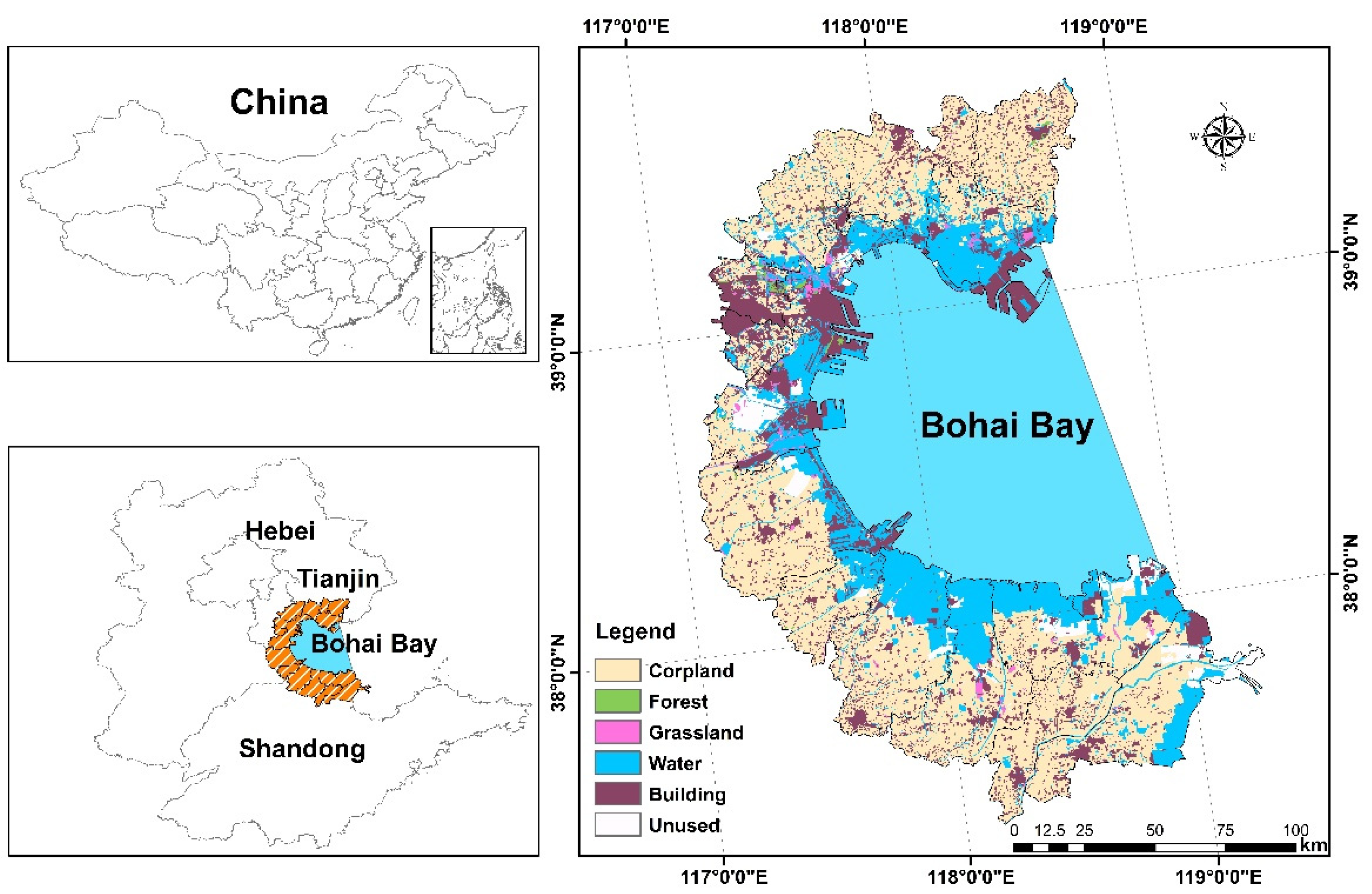
With the expansion of global human activities from land to sea, the urbanization process of the Bay area rich in natural resources has accelerated, and more than 40% of the population is concentrated in the area less than 100 km away from the coastline [
37,
38]. The problem of ecological security in the Bay land area is significant [
39,
40]. Bohai Bay is a densely populated area in China and includes many heavy industrial cities [
21]. Reclamation activities are frequent, and the contradiction between economic development and ecological protection is prominent [
41]. The construction of ESPs in the land area of Bohai Bay can connect regional ecological patches and promote the maintenance and transmission of regional ESs. It is an important way to realize regional ecological security and promote social sustainable development.
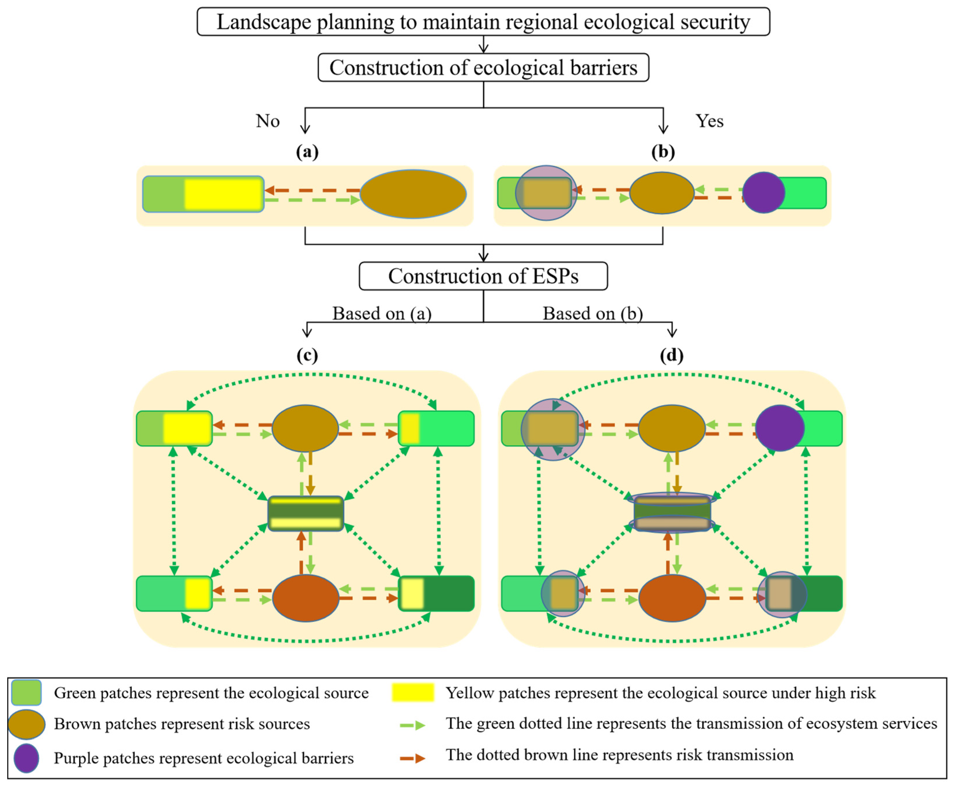
Constructing regional ESPs is an effective measure to maintain regional ecological security [
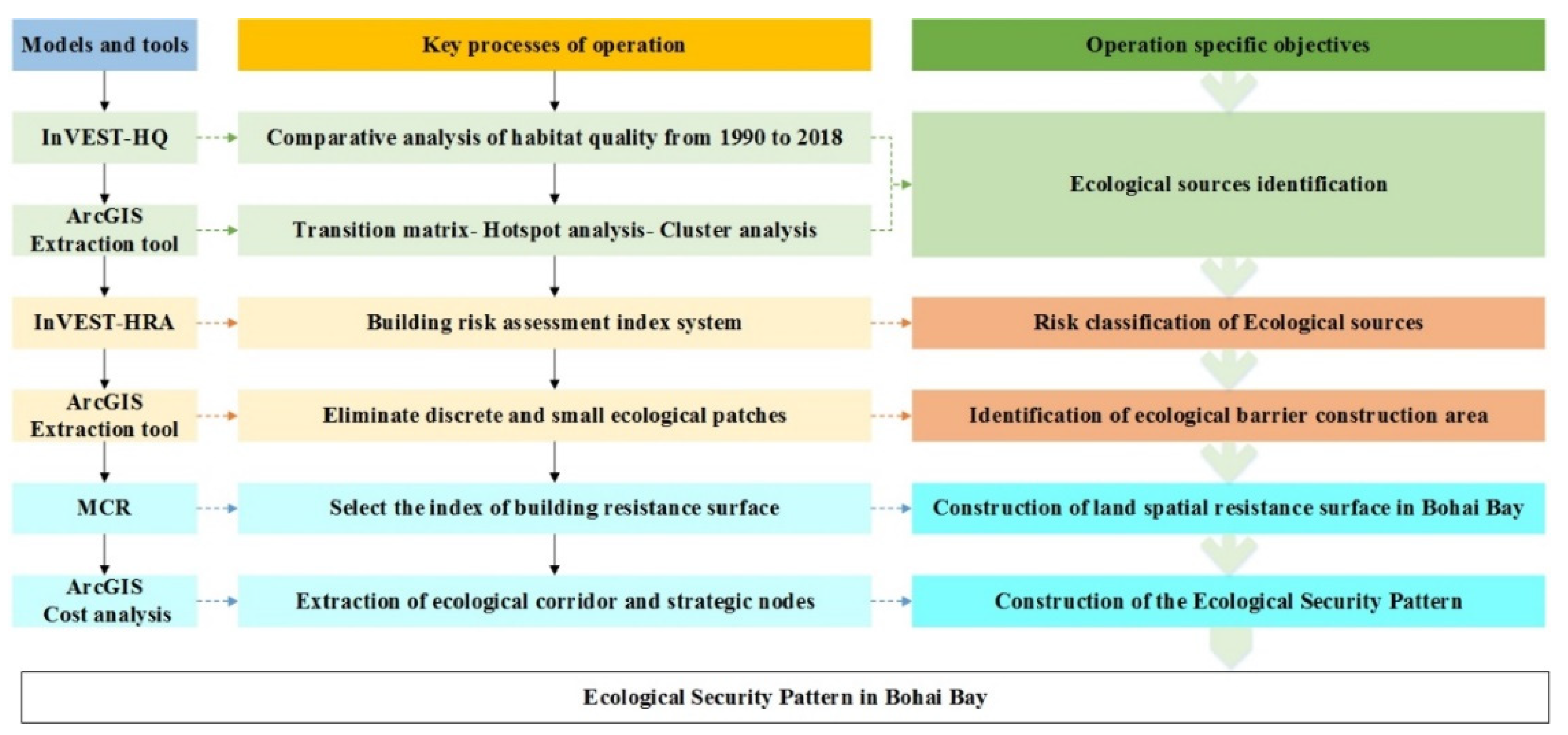
42]. How to optimize the current ESPs to maintain the long-term stability of ecosystem structure and function in the Bay area is an important problem. Therefore, this study used the InVEST-HQ model to analyze the changes of habitat quality in the land area of Bohai Bay over the past 30 years, and selected the ecological sources according to the habitat quality. Considering the instability of ecological source structure and function caused by human activities, the risk of ecological sources was evaluated and graded by the HRA model. And through the identification of ecological barrier zones, ecological source sites are managed differently to guarantee their long-term potential to provide ESs. Ecological sources and ecological barriers are defined as an ecological service supply area. The MCR model was used to extract the regional ecological corridors and ecological strategic nodes to combine with the ecological service supply area to form the optimized ESPs. In order to meet the needs of sustainable human development in the coastal area, this study has theoretical and practical significance for optimizing the process of ecological source identification and establishing ESPs.
Thus, the main objectives of this paper were to: (1) analyze the changes of habitat quality in the terrestrial ecosystem of Bohai Bay over the past 30 years; (2) integrate a risk assessment with an ecosystem service function assessment, modifying ecological source identification and zoning methods and identifying ecological barriers to achieve adaptive an ecological management of ecological sources; (3) build an ESP based on the collection of ecological source selection: ecological barrier identification, ecological resistance surface construction, and ecological corridor extraction; (4) analyze the relationship between ecological barriers and ESPs.
5. Conclusions
In rapidly urbanizing developing countries, where economic development and resource conservation are in conflict, ecological barriers and ESPs in regional landscape planning are both practical ways of guarding regional ecological resources and maintaining regional ecological security using ecological bottom-line thinking. In China, the construction of ecological barriers as a vague concept has played a remarkable role in the protection and restoration of ecosystem structure and function. However, most of the existing ecological barrier construction takes megaregions as the research scale, equating areas with the excellent ecological environments as ecological barriers and focusing on the maintenance of ecological security of the whole region. The overly large research object, combined with the complexity of the ecosystem itself, makes the analysis of ecological barrier structures and functions complicated. This study identifies ecological barriers at the scale of ecological patches using habitat quality and habitat risk assessment, focusing on the maintenance of ecological patches and the transmission of ESs by ecological barriers. At the same time, ecological barriers are integrated into the ESPs, and the framework of “ecological sources—ecological barriers—ecological resistance surface—ecological corridors” was used to construct the ESPs.
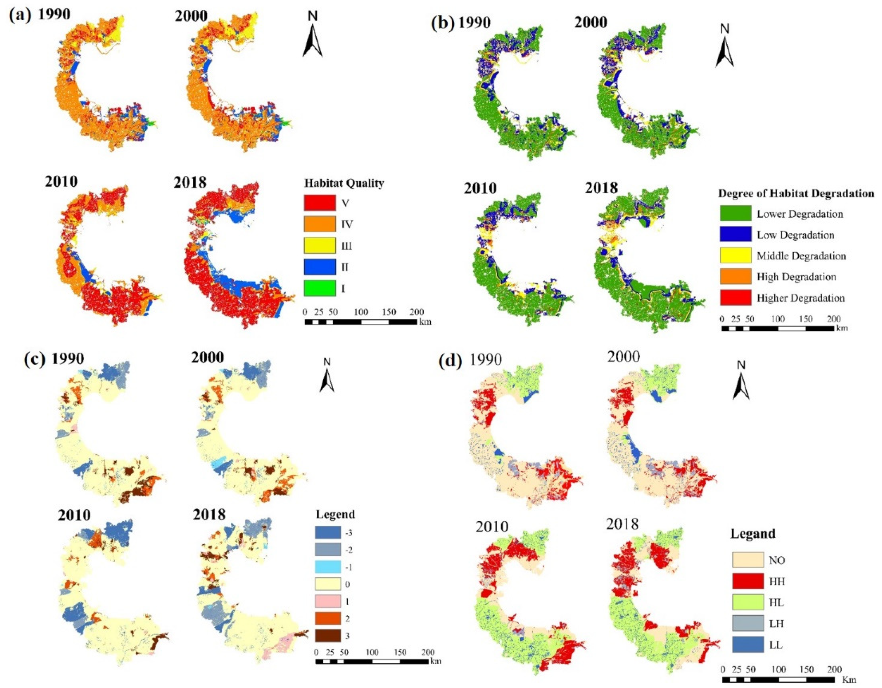
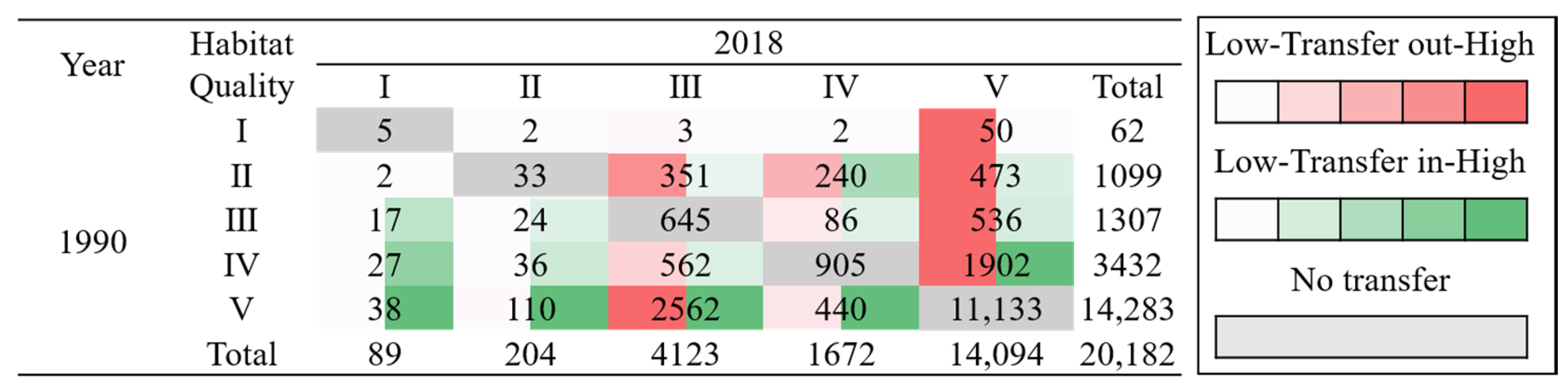
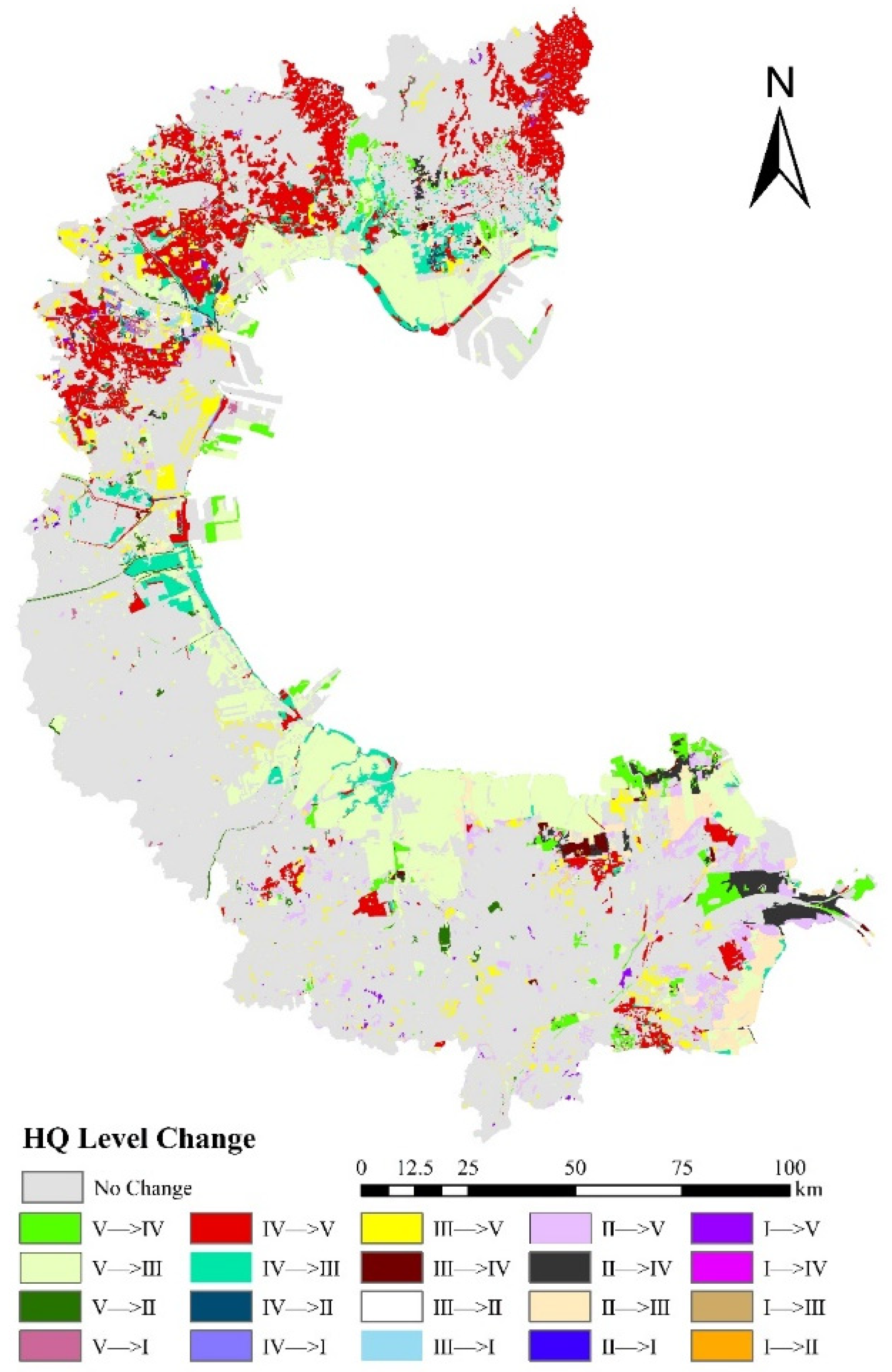
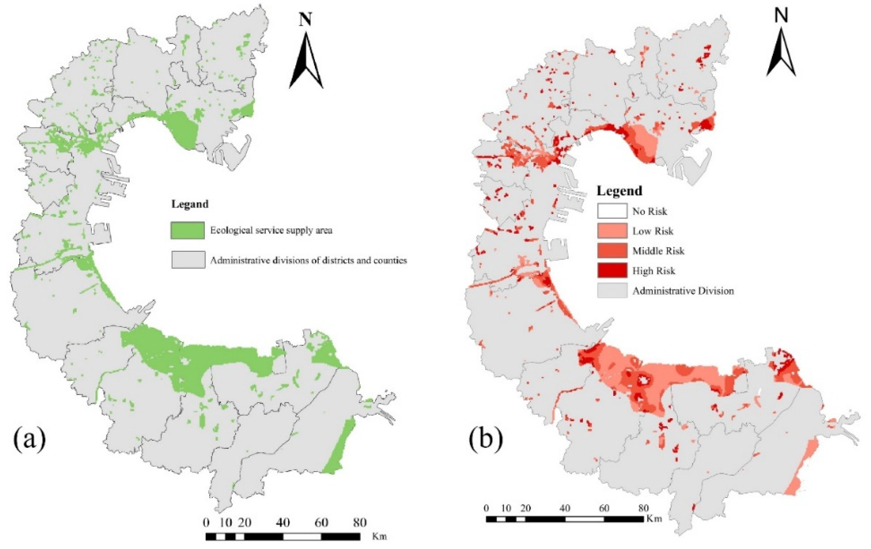
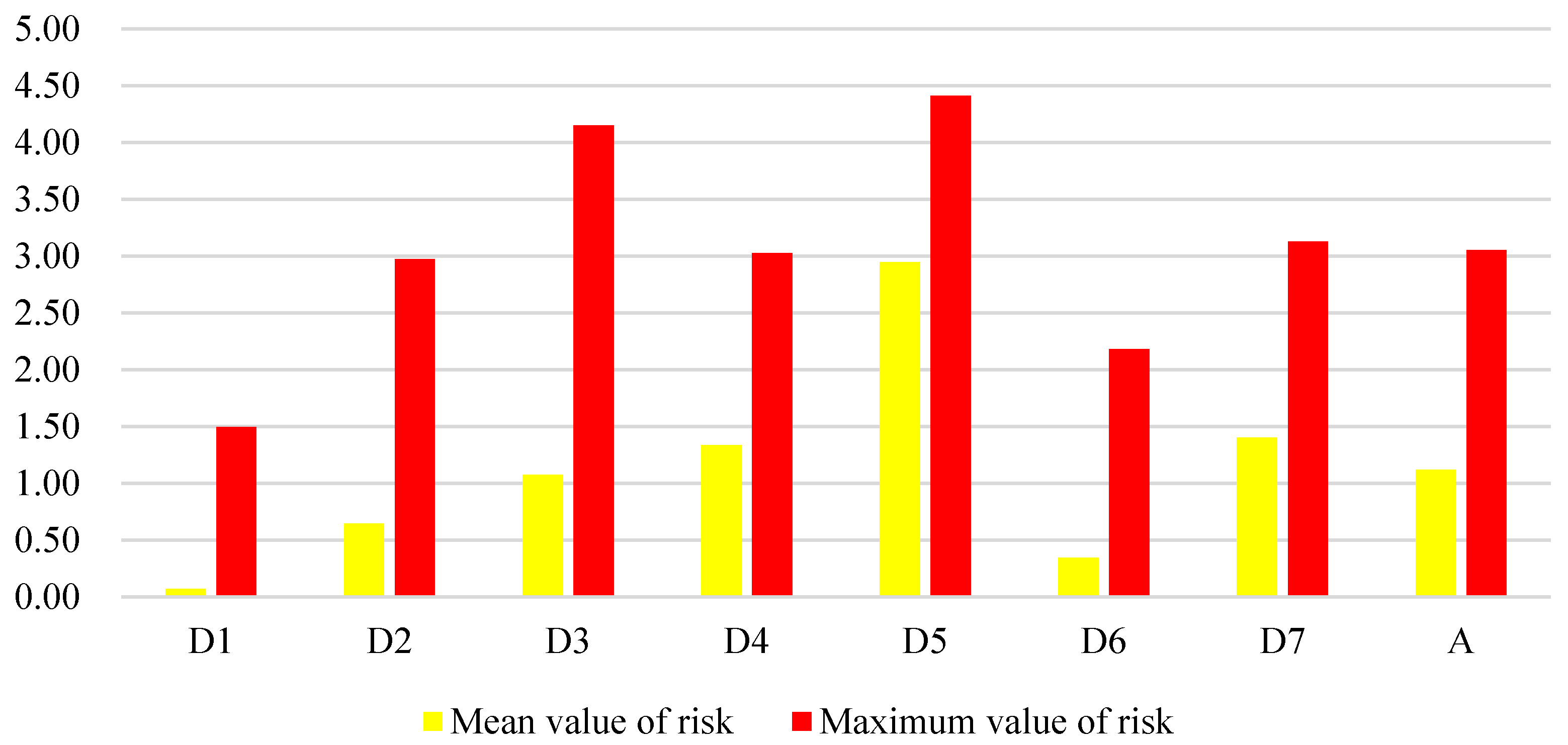
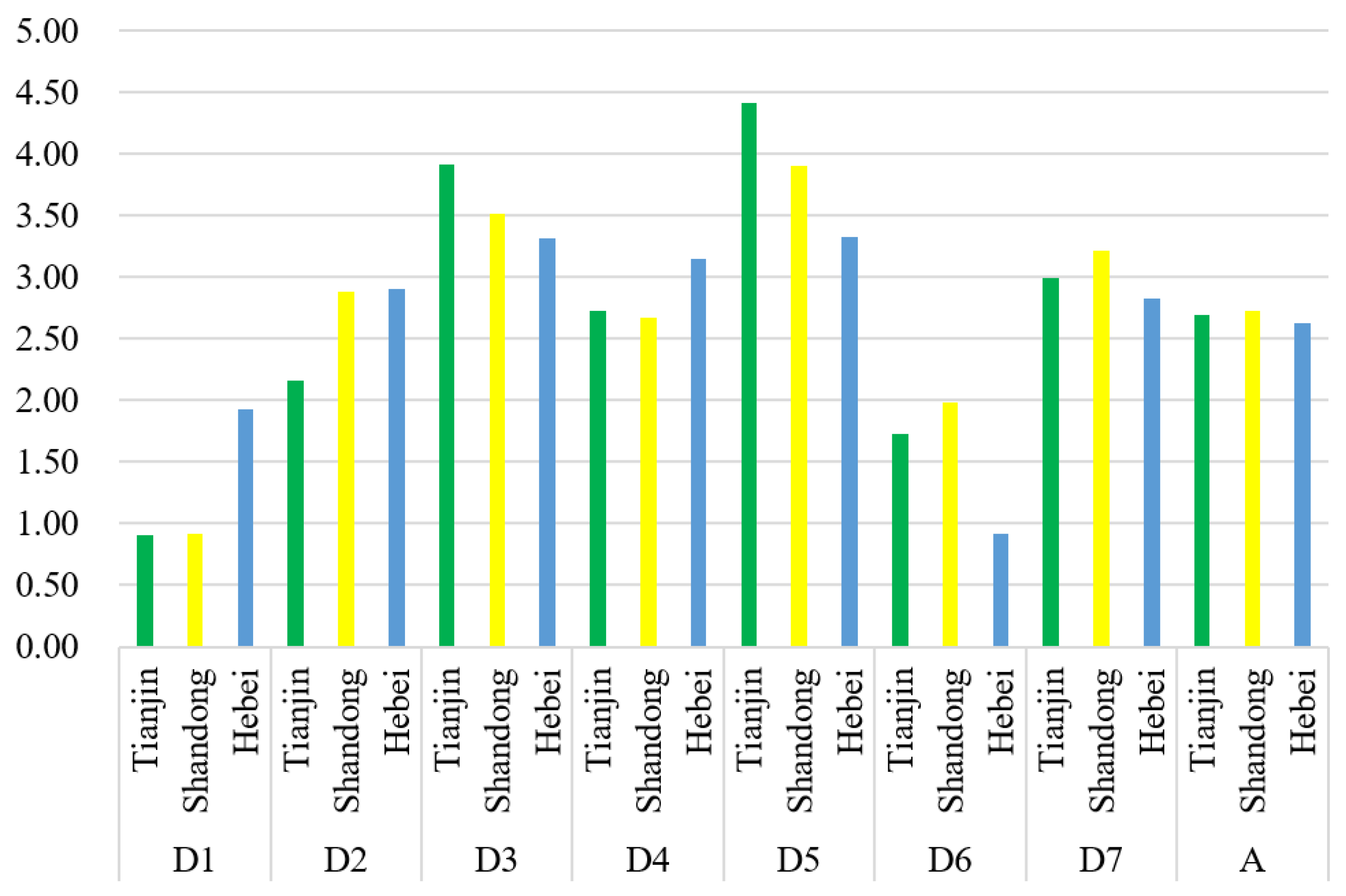
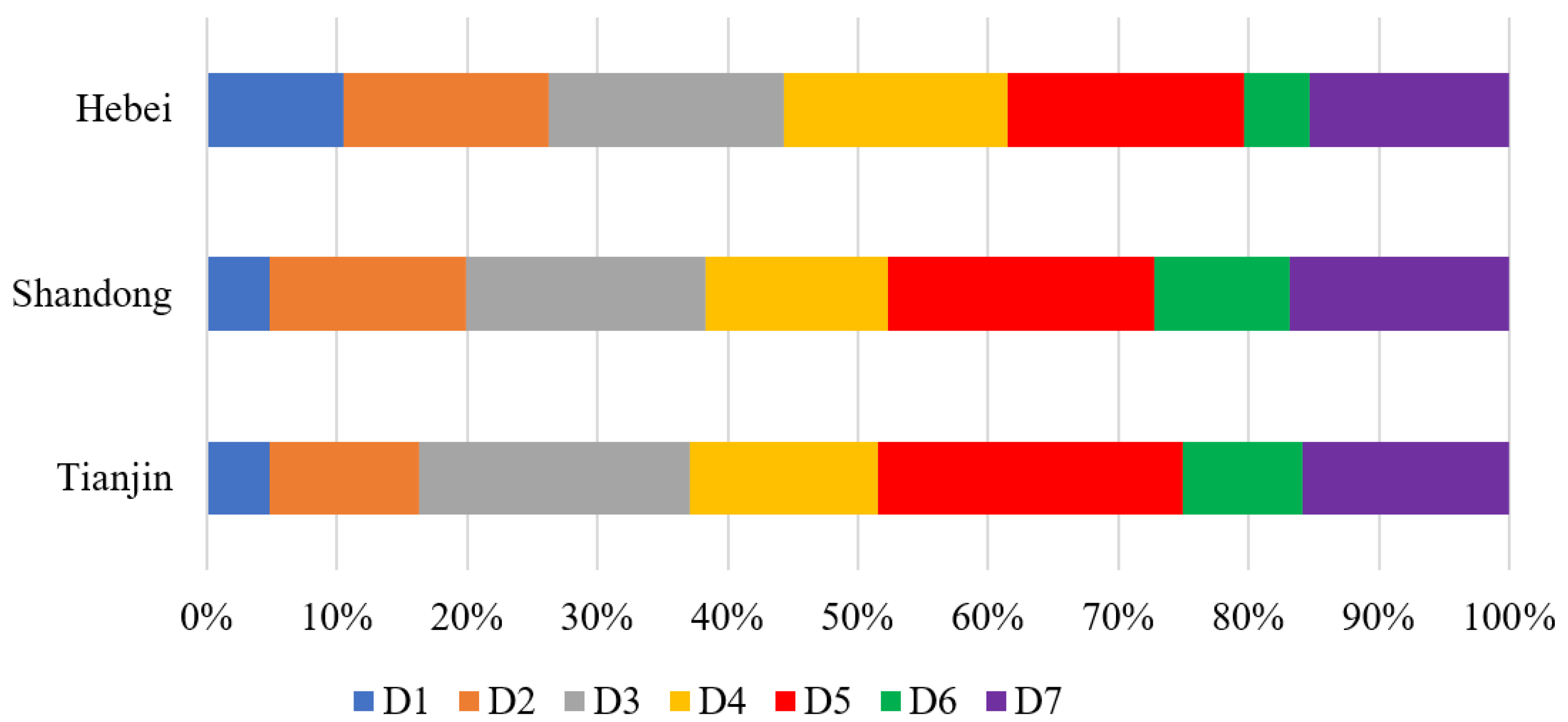
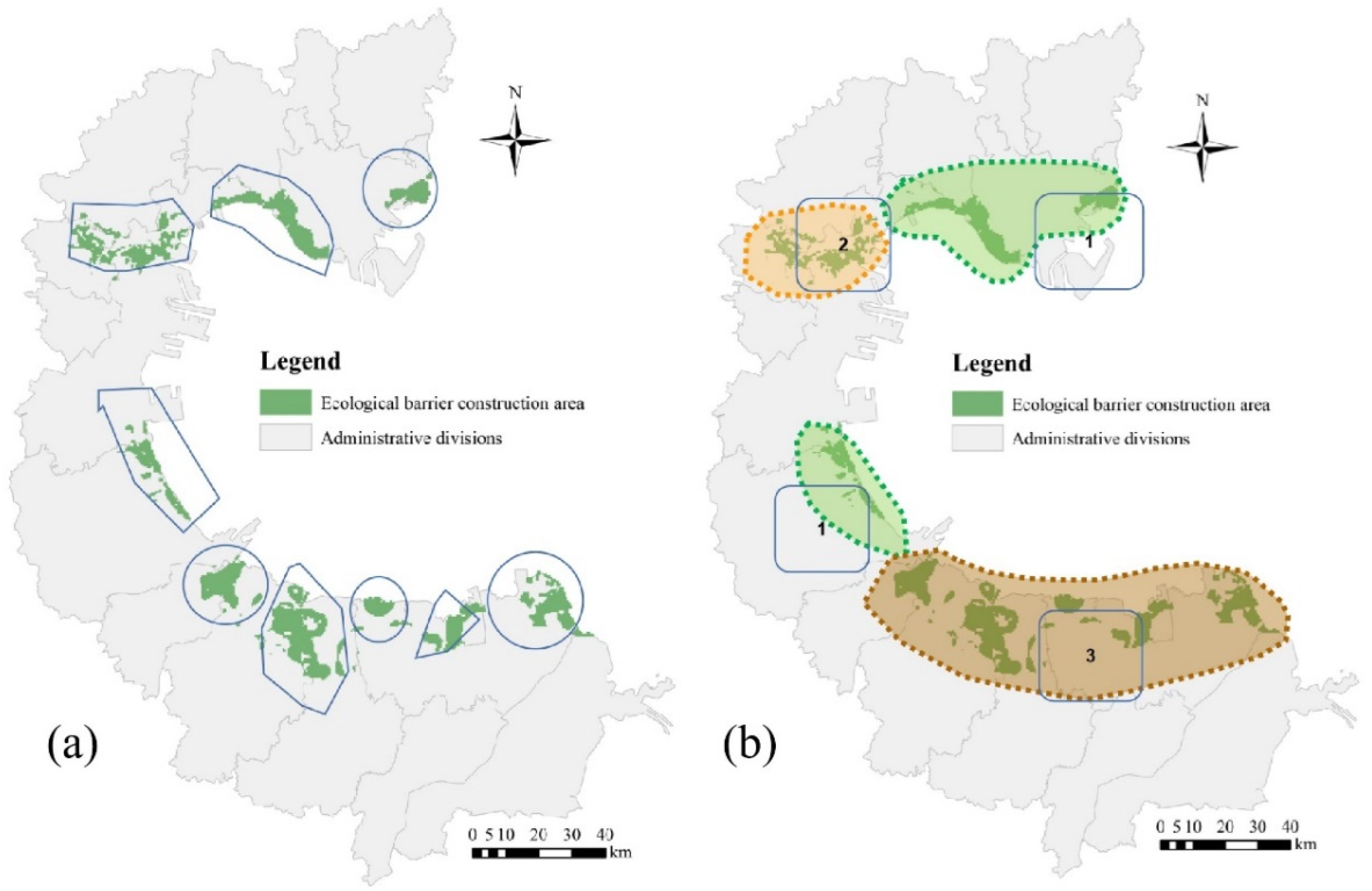
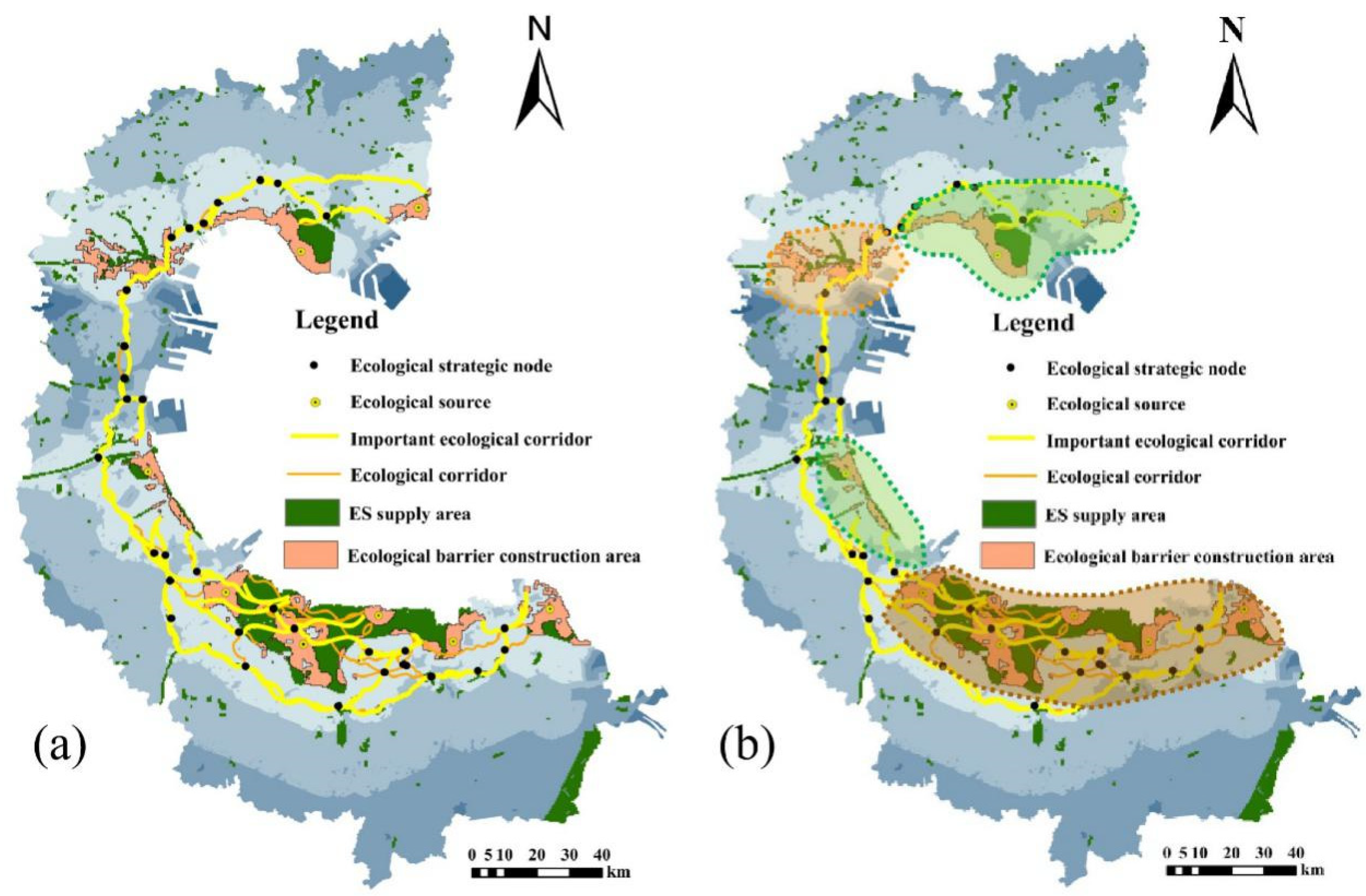
The results of the habitat quality analysis show that the overall habitat quality of the Bohai Bay land area is at a low level, and the spatial distribution is polarized. The area of ecological sources is decreasing in the Bohai Bay land area. The results of the habitat risk analysis show that the ecological sources in the Bohai Bay land area are mainly of medium-risk and low-risk, and the risk mainly comes from the vulnerability of the ecosystem itself. The ecological sources in the Bohai Bay land area are mainly located in the land–sea interface, and the land use types are mainly woodlands, rivers, and grasslands, accounting for 14.3% of the entire area. A total of nine ecological barrier construction cells were identified, accounting for 40.8% of the ecological sources and were divided into three major zones according to the provinces they belonged to. A total of 35 ecological corridors and 32 ecological strategic nodes with rivers and woodlands as the main land types were obtained, including 16 important ecological corridors and 19 general ecological corridors.
However, there are still many problems in the study of ESPs. Although land use is a comprehensive indicator of the structure and function of regional ecosystems and has been used as the basis for most studies on ESs, the link between land cover and ESs behind land use has not been fully resolved. This study focuses on the specific scope and relative capacity of the study area to provide ESs, but does not consider the types of ESs that can be provided in the ecosystem service supply area. Moreover, there is a lack of evaluation on the effectiveness of ecological barriers and ESPs. Therefore, more research is needed to deal with these problems.


