Abstract
This research deals with the problem of the accessibility of urban forests and parks for people with disabilities in wheelchairs. Through an analysis of spatial data, trails were categorized on the basis of the measurements of the independent movements of eight subjects on six trails. The critical longitudinal slopes were determined for independent movement in wheelchairs, complex independent movement with certain risk, and categories of trails that are not suitable for wheelchair movement. The results indicate that a slope of 5.50% was the tipping point, after which all respondents experienced some uncertainty. In addition, a gradient of more than 9.01% was almost impassable for people in wheelchairs, with respect to the gravel trails examined in this study. Modern measurement technology was used in the field, including the mobile apps GAIA GPS and GNSS GPS, and a total (geodetic) station; the subjects’ heart rates were measured using a Garmin Fenix 6 Pro watch. In addition, people with disabilities were included in the implementation of the research through the Croatian Association of Paraplegics and Tetraplegics (HUPT). The results indicate the zones/trails that disabled people in wheelchairs can pass independently, the zones that can be accessed with a certain risk, and those that are not accessible, all according to the defined longitudinal slope zones using measurements of the movement of people in a wheelchair, their heart rate loads, and personal communication with the subjects regarding the insecurity they felt.
1. Introduction
Kept inside by the coronavirus pandemic, which changed previous lifestyles, a significant number of people turned toward nature. People with disabilities experienced this situation much worse because, due to their handicaps, they remained even more imprisoned and limited in their movement in nature. People with disabilities are also looking for their place in nature, but these places are significantly limited for them compared to other people who can reach their desired destination on their own feet. The way people use urban green spaces has drastically changed due to governmental restrictions on social behavior and concerns about infection. These areas provide a full range of ecosystem services [1], including recreation, physical activity, encounter spaces, heat and noise mitigation, air filtration, social networking, and inclusion promotion [2,3,4], which have good effects on people’s general health [5], mental health [6,7,8], wellbeing [9], and physical activity [10,11,12,13].
Access for people with disabilities is often prevented by poorly designed access points to green areas, such as curbs at sidewalk crossings, slopes of the paths, and ramps that prevent passage. With such an approach to planning and construction, we often suggest that wheelchair users and their caregivers should learn the wheelchair skills needed to overcome such accessibility barriers [14]. A good approach to alleviating this problem is the creation of applications that would provide users with information about the possibility of accessing certain locations and the conditions of the infrastructure necessary for wheelchair movement. Accordingly, some applications [15] were created to improve the data and services in the field of mobility for people with disabilities [16]. Similar studies were conducted by [17,18,19,20,21,22,23,24]. However, in addition to marking inaccessible areas and informing users via maps or mobile applications, it is undoubtedly necessary to make local authorities aware of and improve the existing infrastructure to enable unhindered independent movement for people in wheelchairs, as well as to adequately define the standards for the construction of infrastructure suitable for people with disabilities.
The literature does not provide enough quality sources to define the proper construction of trails and other infrastructure for adapted activity. Some EU member states have clear laws on equality for persons with disabilities and guidelines for planning infrastructure adapted to the movement of persons with disabilities [25,26,27], which is not the case in Croatia. The bylaw that ensures the accessibility of buildings to persons with disabilities and reduced mobility [28] regulates precise technical specifications and obligations for designers and building owners; however, there is very poor regulation for trails in terms of width. Working premises are regulated only by general accessibility regulations from the bylaws on the safety at work regarding working and auxiliary premises and facilities [29]. Moreover, by researching this issue, it was observed that no complete park in Croatia has an adequately developed development strategy for people with disabilities or defined parameters for the construction of the entire infrastructure necessary for the movement of people with disabilities in wheelchairs. Neither the law nor the legal regulations for parks and urban forests and strategies for sustainable management have been adapted for all users of grasslands in Croatia.
The literature lists predominantly longitudinal slopes that should be followed when constructing buildings and access ramps for disabled people, and these slopes are usually of different values; some state that the slope should not exceed 1:12 or 4.76° on built ramps and entrances [30]. Kim et al. [31] and Gagnon et al. [32] noted that, in the US, slopes may be steeper than 1:12 for existing buildings and where space is limited, but they should never be steeper than 1:8 (7.13°); however, the latter study also stated that a slope of 0–2.7° (4.7%) was independently mastered by 100% of respondents [32]. Hashizume et al. [33] stated that, according to the law for promoting barrier-free transport and facilities for elderly and the disabled in Japan, the longitudinal slope of the pavement must not exceed 5%, while a slope of up to 8% is allowed in places where this is impossible. Among the types of paths investigated in this paper, there are very little concrete data on the boundary slopes of unbound pavement construction in green areas.
The European accessibility act, a directive that aims to improve the functioning of the internal market for accessible products and services by removing barriers created by divergent rules in the member states, has been promulgated [34]. Although the EAA states what needs to become more accessible, the act does not impose detailed technical solutions or requirements. They do this to allow room for innovation. As a result, small enterprises are released from some obligations. However, by leaving the law open for interpretation, the question persists regarding whether things will change. Only time will tell, but there remains hope that there will be changes in the European Union member states.
The existing longitudinal slopes and macadam surfaces of the paths in Maksimir Park (Zagreb) were assessed and taken into account in this research, as these factors significantly influence the accessibility of the paths for people with disabilities. Through this research, an attempt was made to define the limited longitudinal slopes on the paths in Maksimir Park (Zagreb) for independent movement and to define the slopes where there is a certain amount of risk for the independent activity of people in wheelchairs, as well as threshold slope values that almost no users exceed can master independently. This research topic is only one segment of the obstacles that disabled people in wheelchairs face daily, but it may be one of the most important. The goal is to make those who should care for the walking infrastructure aware of how even small obstacles observed by the “ordinary” eye make it impossible for a person in a wheelchair to move and make use of some of the natural benefits of urban forests and parks. Accessibility for disabled people in wheelchairs includes the conditions that enable them to fully participate in all areas of social life, live independently, and exercise their rights. Therefore, it is necessary to provide access to the physical environment, transportation, information and communication (including information and communication technologies), and other facilities and services open to the public for disabled people in the same way as for other members of society so that they can independently maintain a life suitable for human dignity [35].
2. Materials and Methods
2.1. Research Area
Maksimir Park, a monument of park design architecture, was chosen as the research area (coordinates from 45°49′08″ N, 16°00′46″ E to 45°50′18″ N, 16°01′40″ E) (Figure 1). Maksimir Park is the largest park in the city of Zagreb. The surface area is 316 ha, the elevation of the park ranges from 120 to 167 m above sea level, the average annual temperature is 11 °C, and the annual precipitation is 870 mm, with the most frequent winds coming from the north and northeast [36].
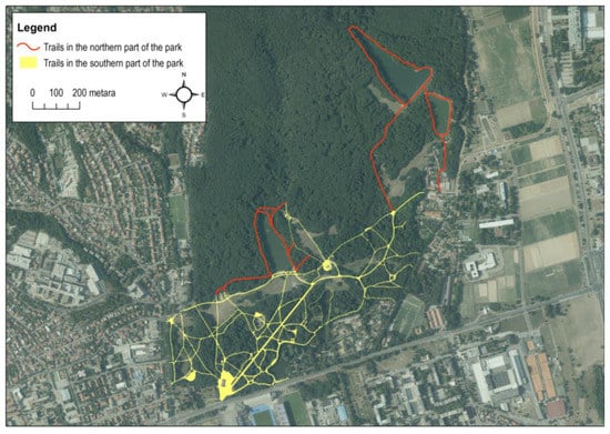
Figure 1.
Research area: Maksimir Park (a monument of park design architecture).
Maksimir Park, one of Croatia’s most important, most significant, and most visited parks, must be accessible by everyone, especially people with special needs and special aids. This research and field survey detected many defects in the researched paths, which need to be changed and adapted for people in wheelchairs. Therefore, the southern part, along with some of the northern part of the park, was selected for the detailed survey. The criteria for selecting routes for wheelchair accessibility research were the longitudinal slope and surface composition. The range of slopes along the route was considered, from almost negligible to extremely steep, as this affects the ease of movement for people in wheelchairs. A gentle slope may be tolerable, while a steeper slope may make it difficult or even impossible to navigate. The selected paths along the route had strictly macadam surfaces without any protrusions or potholes that could cause problems for wheelchair users. The research was conducted on built and maintained paths and paths that lead to areas of high interest (cultural assets, monuments, lakes, children’s playgrounds, cafés, etc.). The southern part is generally more accessible than the northern part for wheelchairs. Nevertheless, even in the southern region (which is of much greater interest to visitors), access to many sights and green areas is blocked.
2.2. Goals and Hypotheses
The goal of this research was to identify the areas available for the independent movement of people in wheelchairs. The results can also be a guideline for the future arrangement of park paths so that they are best suited for people with disabilities who move with the help of wheelchairs. To determine as accurately as possible which routes are best suited for people in wheelchairs, our goal was to determine the mobility on longitudinal slopes by conducting tests on test subjects. This analysis can enable the creation of a map with categorized trails and give suggestions for creating new paths and transition ramps, which will also increase people’s ability to move and access the currently inaccessible park areas. People with disabilities were included in this research through the Croatian Association of Paraplegics and Tetraplegics (HUPT) so that their ability to overcome specific slopes on the macadam surface of the trails could be measured.
The mobility of people in wheelchairs was determined through several stages:
- The surfaces (trails) for independent movement were determined and categorized according to their longitudinal slope, and separate border paths for detailed measurements were determined;
- The longitudinal slopes of all separated trails were recorded using precise modern methods;
- Movement on a longitudinal slope was determined according to the macadam trail construction base;
- A GIS mobility map for Maksimir Park was designed according to the defined categories based on the longitudinal slopes of the trails.
The research hypothesizes that the accessibility of outdoor areas for people with disabilities is a multistage process that involves categorizing surfaces, measuring longitudinal slopes, and designing GIS mobility maps. The design of a GIS mobility map can aid in improving mobility for people with disabilities in outdoor spaces by separating trails for independent movement and categorizing them according to longitudinal slope, which can facilitate better accessibility for people with disabilities.
Precise modern methods can be used to record longitudinal slopes of outdoor trails to improve accessibility for people in wheelchairs. The longitudinal slope is a critical factor in determining the mobility of people in wheelchairs in outdoor areas.
2.3. Field Measurements
Most of the field survey was carried out in 2021. The field measurements of the tracks were carried out in three phases of field work:
Phase 1: Measurement of the paths with the GAIA GPS mobile application, and formation of a GIS database for detailed measurement.
Phase 2: Detailed measurement of the trails with geodetic instruments for the proper categorization of the trail sections, and formation and determination of the parts of the tracks to measure for persons in a wheelchair.
Phase 3: Measurement of the mobility of disabled people in wheelchairs on inclined trails of different slopes concerning the macadam surface of the trails and recording the load via their heart rate.
At the beginning of the study, in Phase 1, a GIS database was formed, which was measured and confirmed by the Maksimir Public Institution. Then, the GAIA mobile app on an Android mobile phone was used to measure and check the accuracy of the database of all trails and observe possible defects or changes. Gaia GPS is an offroad travel app that provides GPS navigation tools to help record movement positions, record referenced points of interest, take geotagged photos, and prepare a digital database for further processing in a GIS program or some other type of software [37]. In doing so, the categories of all existing trails were determined, recording the trails (Figure 2) for the independent movement of persons with disabilities in a wheelchair (green lines), trails that are seasonally available when there is no rain or other precipitation (blue lines), and two categories (yellow and red lines) that needed to be measured in detail to determine the real longitudinal slope and on which to carry out tests with persons in a wheelchair. In addition to recording the trails and their categorization, the positions of all places that were not functioning correctly and potentially obstacles to wheelchair driving were photographed and recorded through the application. Further processing of the data was carried out in the ArcMap 10.8. program, and the local projection HTRS96 in Croatian was used for the complete data mapping.
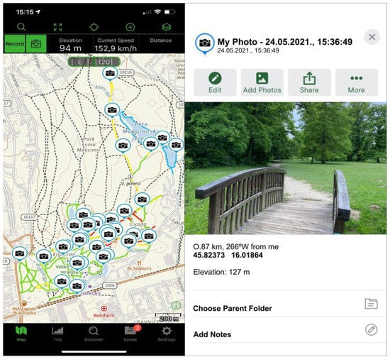
Figure 2.
Measurements using the GAIA mobile app; final database of researched and surveyed trails in the park, with photographs of significant obstacles (application screenshots from a mobile device).
In Phase 2, measurement of the elevation points was performed to maintain the same conditions for all types of measurements regarding the layout of the satellites, the quality of the internet signal, and the weather conditions. Only trails defined by yellow and red colors in the first phase were measured, i.e., the trails that had significant slopes and could be a problem for the movement of people in a wheelchair. All of the fractures in the level of the paths and any changes in the longitudinal slope were measured. The field data were collected using a GNSS device and a total (geodetic) station (Figure 3). Each field data point was collected with a specific device to achieve maximum data accuracy considering the different canopy patterns above the tracks. The GNSS device was the Stonex S900A model (manufacturer Stonex, Milan, Italy), which was equipped with a high-performance 800-channel GNSS board and could support all satellite constellations: GPS, GLONASS, BEIDOU, GALILEO, QZSS, and IRNSS, including L-band–Atlas correction. An integrated E-Bubble sensor allows measuring inaccessible points with an inclined stick. It has an optional IMU sensor with a tilt of up to 60° [30,31,32,33,34,35,36,37,38]. The Stonex S40 controller with Android Cube 4.0 software was used to control the receiver. The total station used was the Stonex R35L (software SurvCE 6.0), with a variable prism height of 2.0–4.6 m.
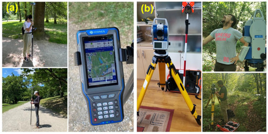
Figure 3.
Measuring devices for recording position points with elevation information: (a) GNSS Stonex S900A receiver with Android Cube 4.0 software on Stonex S40 controller; (b) Stonex R35 total station with TK10 circular prism and a sighting badge, working on SurvCE software.
For research purposes, we needed centimeter accuracy to obtain sufficiently precise longitudinal slopes of the tracks and to determine the border slopes accurately. However, as the research was carried out in an overgrown park, there were parts where the canopy pattern was more pronounced, which affected the accuracy of the GNSS receiver [39]. Other factors, such as the terrain configuration [40], acquisition time (i.e., ensuring enough position fixes per point), and satellite geometry, can also influence the accuracy of GNSS instruments [41]. Therefore, to ensure the necessary higher spatial accuracy, it was required to provide certain preconditions, which, in our case, were enabled by connecting to the Croatian Positioning System (CROPOS) network with the presence of a high-quality Internet signal (4G speed). This allowed us to obtain horizontal accuracy within ±0–2 cm and vertical accuracy within ±0–4 cm. The GNSS receiver was switched on outside the forest to avoid cold-start problems [42] and configured to store data only in FIX mode. Where the canopy interference was more significant, and a sufficiently good satellite or Internet signal was not obtained, a total station was used for the measurement.
The final measurement (Phase 3) occurred at six selected locations (trail parts) of various longitudinal slopes. Eight respondents, who tested six different trails, participated in this measurement. The study involved four female and four male participants of various ages and with different spinal injuries. The severity of each injury was not taken into account in the study, and a minimum threshold was defined for all participants to ensure that trail adjustments and GIS mapping were suitable for all participants and end-users. Their ability to overcome a particular slope and the length of the trail on a specific slope was measured. In addition, a field survey and movement observations were conducted on a slightly sloped trail, where they needed help or moved at a certain risk, and where no independent access to persons in a wheelchair was possible. During the tests, the participants wore a Garmin Fenix 6 smartwatch, which provided valuable information, such as their pulse measurement and warnings for high heart rates (Figure 4). As they traversed a designated trail, their heart rates were monitored at the start and end of each slope segment. The arithmetic mean was calculated from these two data, which were used to create the regression graph. These data should help define the threshold slope. The point of significant effort was a heart rate above 100 bpm, considered in many studies in the literature as the threshold rate of beats at rest or low effort. The data were further processed in Office 2016 with data transfer from the Garmin Express program. The data of the movement of all respondents on each trail were displayed on a graph with the longitudinal trail profiles and the points of reach of each individual participant.
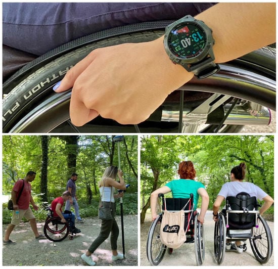
Figure 4.
Heart rate measurement by Garmin Fenix 6 Pro watch; measuring segments of change of longitudinal slope on the trails.
Additionally, direct communication with participants was used to gather immediate feedback on their sense of security while traversing certain steep slopes. A scale of 1–5 was designed to create a survey about the feeling of insecurity when moving along sections of certain inclines, for which each respondent expressed the level of insecurity felt. The scale represents five categories, with 1 representing a feeling of complete safety for independent movement, and 5 representing a very high level of uncertainty for independent movement, or even the physical impossibility of overcoming such slopes:
- No insecurity when moving independently.
- Extremely small feeling of insecurity when moving independently.
- Average uncertainty during independent movement.
- Significant uncertainty when moving independently.
- Very high uncertainty, or no possibility of overcoming the slope.
The participants in the research study evaluated trails while they rode on them, and their evaluations were recorded on a mobile device to create a database for all participants and individual sections of the longitudinal slopes. This methodology allowed a detailed analysis of the participants’ opinions on the trails, as well as their mobility and insecurity level.
2.4. Data Flow Diagram and Proposals of Solutions for Availability of All Contents of the Park
For a more transparent presentation of the data, a data flow diagram was created (Figure 5), showing all steps from forming the initial base of the tracks to using the GAIA application for quickly recording and updating the tracks. At the latter stage, a decision was made about the paths that needed to be measured in more detail to determine their longitudinal slope precisely. Lastly, accurate longitudinal slopes were obtained through further measurement with geodetic instruments, which were the basis for later measures of the mobility of people with disabilities in wheelchairs. Considering that no one person is the same, It was challenging to determine the threshold slopes for independent movement; hence, it was necessary to decide on the threshold slopes by measuring the pulse, gathering the opinions of the respondents themselves, and obtaining the final result in the form of a GIS map of the researched area.
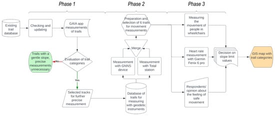
Figure 5.
Diagram of the flow of data until reaching the goal in terms of defining the mobility categories of people with disabilities in wheelchairs.
3. Results
Before going out into the field, all potential applications with which we could record and display all of the trails of interest were investigated, and the GAIA GPS application was selected. As a result, all of the trails that lead to all facilities that visitors can see in Maksimir Park were recorded. This updated the database taken from the Maksimir Public Institution and defined four categories of trails for further analysis.
The recorded trails were divided into four categories: (1) green trails, which did not need to be recorded in detail due to their slight longitudinal slope; (2) yellow trails, which have a moderate slope and needed to be recorded in detail with geodetic instruments; (3) red trails, which are steep and were recorded in detail with geodetic instruments; (4) blue trails, which are potential driving lanes with a change in the pavement structure.
Along with recording the tracks and their categorization, over 30 photos were recorded of the locations where the infrastructure was not built correctly and was a potential obstacle for wheelchairs. These images were also made using the GAIA GPS application, and these places’ positions were recorded with coordinates in the WGS84 projection. After the end of Phase 1, the data of the preliminary categorization of the paths were obtained on the basis of the assessment, and the total length of the trails was obtained, which needed to be measured in more detail using geodetic devices. Then, all of the yellow- and red-marked trails were measured.
A total of 15,232 m of trails were recorded by the field assessment and the GAIA application (Figure 6); the evaluation assigned a total of 66.39% of the total length to Category 1, 16.84% to Category 2, 13.79% to Category 3, and 2.98% to Category 4, which included the unmaintained trails that are only mobile during dry weather. With this, the categories for further detailed measurement (yellow and red trails) were selected, which totaled 4666 m, or 30.63% of the total surveyed trails.
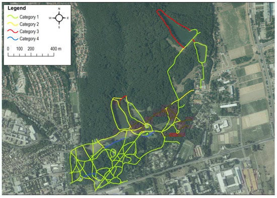
Figure 6.
Categorization of trails based on assessment and recording with the GAIA GPS application (Phase 1).
The subsequent research phase measured the trails obtained in the previous step. Using the Stonex S900A GNSS device with the application of the Cube 4.0 program on the Stonex S40 controller, the trails were measured in the middle, and the vertical profiles of all calculated trails were defined. A different number of points were selected on each track, recorded with the GNSS device, and their numbers varied due to the breaks in the longitudinal slopes (changes in the slopes) of the individual trail. Due to the assumption that the GNSS device would not accurately record the points under the denser canopy, a geodetic measuring station was also used, but only on two tracks because, during the field survey, it turned out that the GNSS device managed to record the points with high precision with a low position dilution of precision (PDOP) value even under the canopy, which enabled faster and high-quality measurement. On the trails measured in detail, the maximum longitudinal slope reached a value of 32%.
With the completed detailed survey, six tracks were selected for measuring the mobility of people with disabilities in wheelchairs. This test was carried out with the cooperation of the HUPT association and included eight people: four women and four men of different ages. It tested how long people in wheelchairs could travel on different slopes. The six selected tracks had different slopes ranging from a minimum of 1.92% to a maximum of 18.81%. During the testing, the subjects wore a GARMIN Fenix 6 smartwatch, which contributed better information, such as heart rate measurements and warnings for a high heart rate while a particular person was moving along one of the listed paths. In addition, the heart rate was monitored at the beginning and end of each section of the longitudinal slope. Accordingly, the results of this research are analyzed in the graphs below.
The first graph (Figure 7) shows the first tested trail. Most of the participants could cover the entire 100 m trail. It should be mentioned here that all respondents reported insecurity on the second section of the track at a slope of 6.84%. Six out of the eight subjects finished the whole or almost the whole course with certain risk, while two traveled only 40 m before they felt unsafe with independent movement.
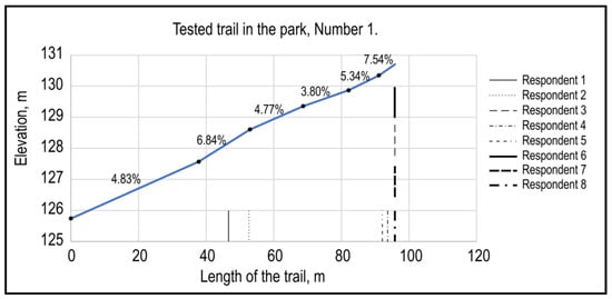
Figure 7.
The results of the successful movement of people with disabilities in wheelchairs on Track 1; the test was carried out by eight respondents.
The second trail (Figure 8) was quite different and only had three key slope points, with the highest grade in the middle of the trail, at 7.51%. However, 50% of the participants managed to complete the entire trail. On the other hand, the other 50% of the participants finished halfway, stopping at approximately the highest point of the slope. The feeling of insecurity stopped 50% of the respondents, while the remainder continued with conscious risk and overcame the 7.51% slope section with difficulty.
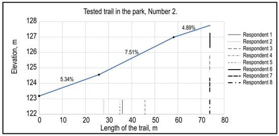
Figure 8.
The results of the successful movement of people with disabilities in wheelchairs on Track 2; the test was carried out by eight respondents.
Track 3 (Figure 9) was 75 m long and was measured with four participants. The highest point of the slope was at the trail’s end, at 6.45%. This trail can be described as the one with the greatest success for the participants with disabilities, as all four participants completed the entire course. Nevertheless, in the last part of the trail, they all declared they felt a certain amount of uncertainty and risk.

Figure 9.
The results of the successful movement of people with disabilities in wheelchairs on Track 3; the test was carried out by four respondents.
The fourth track (Figure 10) was the longest (140 m), with two sections with a large longitudinal slope. However, only three participants managed to complete the entire course. We observed that the two participants had almost identical results and stopped at the top of the steepest slope of 8.42%. Two stopped at the beginning of the steepest slope due to uncertainty and risk in continuing to move along the trail.
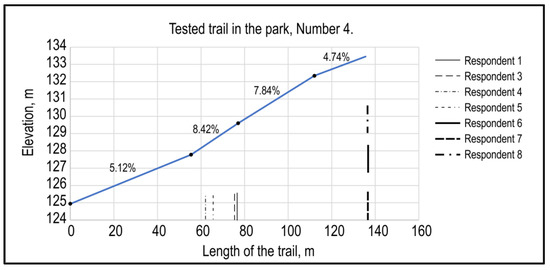
Figure 10.
The results of the successful movement of people with disabilities in wheelchairs on Track 4; the test was carried out by seven respondents.
Graph number 5 (Figure 11) shows the path that can be characterized as that with the shortest length (30 m) of all included in this study. However, this track had an extreme longitudinal gradient, with a minimum of 9.01% to a maximum of 18.81%. Five subjects were involved in the examination of this path. Two participants completed the first 10 m of the course and stopped at the beginning of the highest point of the slope. The last two participants managed to finish a few meters before the end of the 9.01% section but stopped due to their inability to move.
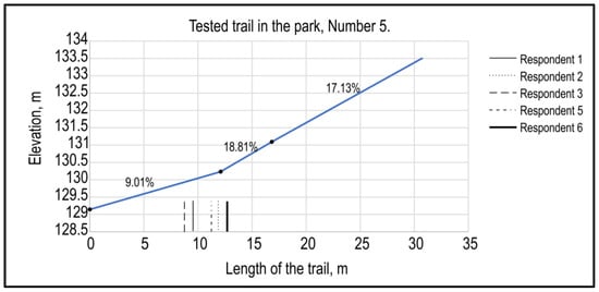
Figure 11.
The results of the successful movement of people with disabilities in wheelchairs on Track 5; the test was carried out by five respondents.
Figure 12 shows the last trail in which there were only two participants. This trail was one of the shortest in terms of length and the easiest in terms of slope, as it had a gentle slope of up to 4.75%. Accordingly, both participants managed to complete the entire course.
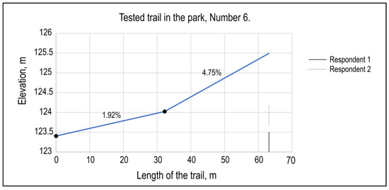
Figure 12.
The results of the successful movement of people with disabilities in wheelchairs on Track 6; the test was carried out by two respondents.
All subjects did not access all longitudinal slopes of the trails because they did not manage to reach the end of all the tested trails. In addition, for Trail 6, only the respondent with the worst results on the previous five trails took the test because Trail 6 had the mildest longitudinal slope. To better define the border categories of slopes, a survey of the candidates was also conducted on their feeling of safety when crossing a certain longitudinal slope.
Through the survey, we obtained results showing that not a single respondent had a feeling of insecurity up to a slope of 5.34% (Table 1), regardless of the length of the section that needed to be covered up to the value of that slope. Likewise, above a slope of 9.01%, no candidate who took part in the test could overcome the track with such a large longitudinal slope. Moreover, no single candidate dared to start on such a steep slope. It can be observed in the average scores of the respondents that the average values ranged from 2.07 to 2.50 for respondent numbers 1, 2, 3, and 5. Moreover, these respondents were female, while the other respondents were male; thus, we can say that the female respondents felt more insecure when overcoming steeper slopes.

Table 1.
Results of a poll of participants about the feeling of safety when moving along a particular longitudinal slope.
The heart rate was measured in all subjects for each section of the longitudinal slopes, and the arithmetic mean was determined for each section. Of course, these data varied from person to person due to their physical fitness, health condition, and the level of spinal injury of the respondent. Therefore, these data may not be relevant, but they can help us when determining the threshold slope for the independent movement of disabled people in wheelchairs. A power trendline was used in the regression analysis (Figure 13); a curved line is best used with datasets that compare measurements that increase at a specific rate [43].
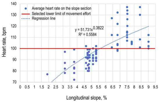
Figure 13.
Heart rate measurement results on specific sections of the longitudinal slope along each measured trail for all respondents.
The R2 in the analysis was over 50%, which was more than expected because people of different fitness levels and, in this case, health conditions had more significant variations. In most cases, the R2 was less than 50%. People are more complex to predict than physical processes [44].
Following all the analyses carried out, the maximum longitudinal slope for Category 1 trails allowing independent movement was defined as 5.50%, while a 9.01% slope was determined as the maximum longitudinal slope above which independent movement is not enabled for people with disabilities in wheelchairs, and which creates a very high feeling of insecurity in the case of forced movement along such a trail. On the basis of these defined categories, we obtained a final result, and a GIS map was created for all the researched trails (Figure 14). We determined the impassable surfaces for people in wheelchairs; thus, we could conclude which facilities are inaccessible and where certain work needs to be carried out to enable access to all of the park’s facilities.
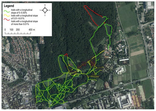
Figure 14.
GIS map of all researched trails according to defined categories of longitudinal slope.
Following precise field measurements with geodetic instruments and the formation of categories based on the measurement of the mobility of people in wheelchairs, we arrived at different results than the assessment in the first phase of work. The first category (0–5.50%) included a total of 83.43% of the length of the paths, the second category (5.01–9.01%) included 4.71%, and the third category (>9.01%) included 11.86%. The tracks without an upper macadam layer, registered as Category 4 in this analysis phase, were eliminated and are not reported in the results.
4. Discussion
Some studies have indicated that, after the first COVID-19 lockdown, everything returned to normal, and the drastic increase in (urban) forest visits at the start of the lockdown was a temporary effect [45]. However, for people with disabilities in wheelchairs, the feeling of impossibility continues due to the often-inaccessible locations of high interest. What should be mentioned is that many people with disabilities want to move independently in green areas, primarily for recreation and health reasons. Many authors have stated that regular physical activity and exercise can reduce the risk of certain diseases, such as diabetes, hypertension, cardiovascular diseases, and respiratory diseases [46,47,48]. It can be stated that the conditions of movement have not changed from those before and during COVID-19. Nevertheless, we cannot ignore the statements of respondents who claimed that, at the moment of lockdown, all the locations they frequented such as cafés, restaurants, small fenced parks, public toilets, and shopping centers, had restricted access. Thus, during the lockdown due to COVID-19, they, like other people, were forced to look for their place in nature, turning toward places such as parks that offer oases of peace. This ordeal also affected people with disabilities in wheelchairs. Only then did all the possible field obstacles that were often ignored by the companies that manage such parks and protected areas come to the surface.
During this research and field survey, numerous deficiencies were identified that require modification and adaptation to facilitate the movement of individuals with disabilities who use wheelchairs within the park. The southwestern area of the park is mostly accessible to wheelchair users; however, in the eastern section, several trails do not meet the slope limit defined by this study. The primary issue is that most of these trails are short with a steep longitudinal slope, hindering access to the various attractions that Maksimir Park offers.
By comparing the data of the assessment and the detailed measurement, significant differences are visible in Categories 1 and 2 (Figure 15), which tells us that, without a precise instrument and a proper methodology for determining the boundary slopes, it is challenging to decide between easily passable trails and those with a very steep slope. The obtained results indicate that the limit of a slope for independent movement on a macadam surface of a trail is 5.50%; in this slope zone, there is almost no sense of insecurity or risk for people with disabilities in wheelchairs. On the other hand, above a 9.01% slope, the test subjects did not even dare to move on such a track surface due to the high level of uncertainty and risk that such movement entailed. Similar categories were mentioned by Zeller et al. [49], who defined slopes by category for hard-paved surfaces as follows: easy—slopes of ≤5%, mobility with little or no assistance; moderate—slopes of 5–8%, mobility may require assistance; difficult—slopes of 8–10%, mobility may require assistance; most difficult—slopes of ≥10%, mobility will require assistance. Likewise, the basic design parameters of paths for people with disabilities in Sweden were stated by Lundell [50].
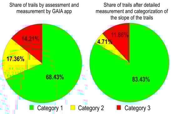
Figure 15.
Comparison of the share of individual categories of trails according to the method of personal assessment and detailed measurement, based on the definition of slope categories concerning the mobility of people in wheelchairs.
One of the most crucial factors, along with longitudinal slopes, is undoubtedly the surface on which people with disabilities move. These surfaces should be compact and have good adhesion. However, the surface studied in this research was unbound crushed stone (macadam). Janeczko et al. [51] reported that 77.2% of respondents in Slovakia found this surface to be the least friendly for wheelchair movement, while, in the Czech Republic, the number was 68.2%, and, in Poland, it was 42.3%. It is assumed that future research on solid surfaces will yield results indicating that independent movement on such surfaces with greater longitudinal slopes is possible due to better grip and a greater sense of safety while moving.
Modern measurement technologies, such as geodetic instruments, especially the GNSS device that worked perfectly under the canopy assembly in the park, enabled quick, simple, and precise data collection for further processing and analysis. The GNSS recorded locations on the basis of the information received from the satellites (independent of the location of other points). As the research area was sparsely forested land with good GPS signal coverage and an Internet signal for connecting to CROPOS, we can conclude that the GNSS generally provided precise and reasonable measurements under this forest canopy condition [52]. Working with the GAIA GPS mobile application also proved to be a good and fast way to collect basic information, form a database, and update existing databases. Moreover, due to the ability to create georeferenced photos, the situation on the ground (visualization) was very easily connected with the spatial positioning in GIS programs.
An analysis of the respondents based on their heart rate measurements is not a reliable method, especially using a smaller sample, because it is difficult to compare people (especially people with different degrees of disability). Nevertheless, this information can help in the final decision. Such research is common; for example, in the research of hiking trails, heart rate measurements are used to determine the possibility of passing the trail and to set a certain number of rest stops for groups of people who are in poor condition and of older age [53].
The mobility of disabled individuals necessitates a considerable amount of information regarding the trail elements. Unfortunately, in numerous instances, such information is entirely absent or unavailable in appropriate data models that can assist routing services [16]. Therefore, physical maps should be placed in visible places at the entrances of all green areas, and today’s increasingly popular mobile applications should be developed to be able to access databases on the state of trails and participate in supplementing them as a user. The World Health Organization’s World Report on Disability [54] emphasizes the importance of ensuring that individuals with disabilities have access to physical and social environments that enable their full participation in society. The development of a GIS mobility map, such as the one proposed in the present study, has the potential to increase the accessibility of public spaces for individuals with spinal cord injuries. However, in order to ensure that these maps are truly inclusive, it is important to consider the diverse experiences and needs of individuals with disabilities.
In the future, for more sustainable access to parks, the construction of paths composed entirely of aggregate material should certainly be considered. When tracks are built in this way, according to the given parameters, it is possible to maintain the original condition for an extended period with less maintenance [49]. To solve this problem, thorough, ergonomic, and sustainable planning of open urban spaces, considering the needs of people with disabilities, is essential. Furthermore, the design and applications of these spaces must be shaped according to accessibility standards for people with disabilities to create an environment that is accessible and adapted to their needs [55]. This implies the application of various accessible solutions, such as wide trails that allow for the easy movement of wheelchairs, built-in gentle trails instead of stairs, the accessibility of public areas for people with disabilities, and the use of sound signals and other aids for orientation for blind or partially sighted people. It is also important that, when planning open urban spaces, different types of disabilities are considered, and an environment adapted to everyone is designed. When it comes to public spaces, the concept of universal design has gained significant attention in recent years. Universal design aims to create spaces and products that are accessible to all people, regardless of their abilities. This approach involves designing with the needs of disabled people in mind, while also recognizing that accessibility benefits everyone. In the words of Steinfeld and Maisel [56], “designing for accessibility is designing for all”. The concept of universal design emphasizes the importance of creating both functional and aesthetically pleasing spaces that do not stigmatize disabled people by labeling them as different or in need of special treatment.
Accessibility is a key aspect of designing inclusive and accommodating spaces for all people, regardless of their physical abilities. Environmental barriers can be just as disabling as impairment itself, and designing spaces with accessibility can help to reduce these barriers [57]. Therefore, it is important to consider accessibility when designing public spaces. Research issues highlight the importance of considering the social model of disability, which recognizes that disability is not solely the result of an individual’s impairment but is also shaped by environmental barriers [58]. Inclusive design principles, such as those outlined in Inclusive Design: Designing and Developing Accessible Environments [59], are based on this model and emphasize the need to create environments that are accessible to all individuals, regardless of their abilities.
Study Limitations
This study presented limitations that need to be considered when interpreting the results. The results should be interpreted with caution owing to the convenience sample, including a relatively small number of participants (n = 8) and its potential effect on statistical power. The present study investigated the mobility of individuals with spinal cord injuries and aimed to develop a GIS mobility map for Maksimir Park based on defined categories concerning the longitudinal slope of the trails. The study had several shortcomings, including not considering the injury’s severity; moreover, the average heart rate was taken, and the value of crossing over 100 beats per minute was observed, which could also have been determined otherwise, but the authors decided on a value representative of average load. The authors’ focus was on developing a methodology in order to avoid some problems with measurement and data processing in research, as well as determine the limit slopes on different movement surfaces in the future.
It should be noted that there was a visible difference among the subjects. Some stopped on most of the tracks due to movement, while one subject managed to overcome all tracks with varying degrees of risk. Future research should consider the subjects’ physical condition and their participation in specific sports. The subject who overcame all the trails was an active recreationist and athlete. Additionally, in comparison categories, males and females should be analyzed separately. This research demonstrated that men found it easier to overcome critical slopes, but this statement requires confirmation based on a larger sample.
5. Conclusions
Through this work, quality communication was achieved between people with disabilities in wheelchairs and the professionals that should ensure the availability of all contents in parks and protected areas of high interest for visitors. With a proper and gradual approach to this type of research, it is possible to determine the actual movement possibilities of people with disabilities in wheelchairs using the presented methodology. Modern methods and instruments make measurements more accessible, digital field data can be obtained more quickly and with less possibility of error during processing and analysis, and the final results undoubtedly provide a concrete application.
Certainly, further research should also investigate other surfaces because, through communication with the respondents, data were obtained on how bound materials in the construction of paths facilitate movement and provide greater safety, whereby it is easier to stop while moving down a slope, etc. The values of different types of surfaces would give different results for the categorization of slopes for independent mobility, thus also providing guidelines for better-quality, safer, and ultimately, more sustainable ways of managing parks and other green areas while considering a more vulnerable group of people.
In conclusion, while our study had some limitations, we believe that our findings are important for improving the accessibility and mobility of people with disabilities in public spaces. Our results suggest that precise geodetic measurements are necessary for designing accessible trails and identifying suitable surfaces for independent movement. Researchers should seek to include people with disabilities in the research process, as they are in the best position to understand their own experiences and needs, as considered in this research. We hope that our study can contribute to future research in this area and help to inform policymakers and designers on how to create more accessible and inclusive public green spaces for people with disabilities.
Author Contributions
Conceptualization, K.L.; methodology, K.L.; software, K.L.; formal analysis, H.N.; investigation, O.P., A.R. and V.L.; resources, K.L.; data curation, H.N. and K.L.; writing—original draft preparation, K.L.; writing—review and editing, H.N.; visualization, O.P.; supervision, K.L.; project administration, K.L.; funding acquisition, O.P. All authors have read and agreed to the published version of the manuscript.
Funding
This research received no external funding.
Institutional Review Board Statement
The study was conducted in accordance with the Declaration of Helsinki and approved by the Ethics Committee of the Faculty of Forestry and Wood Technology, University of Zagreb (EP04-22/23, 21 May 2023) for studies involving humans. The opinion document and the Decision of the Ethics Committee are available in Croatian language.
Informed Consent Statement
Informed consent was obtained from all subjects involved in the study.
Data Availability Statement
The data for this research can be shared upon request to the authors.
Acknowledgments
The authors acknowledge with deep gratitude the support of the Faculty of Forestry and Wood Technology, University of Zagreb, through the student project “Go Wheel the Park” (GO WTP). The authors also wish to thank the Maksimir Public Institution and the Croatian Association of Paraplegics and Tetraplegics for all their support during this research.
Conflicts of Interest
The authors declare no conflict of interest.
References
- Haase, D.; Larondelle, N.; Andersson, E.; Artmann, M.; Borgström, S.; Breuste, J.; Gomez-Baggethun, E.; Gren, Å.; Hamstead, Z.; Hansen, R.; et al. A quantitative review of urban ecosystem service assessments: Concepts, models, and implementation. Ambio 2014, 43, 413–433. [Google Scholar] [CrossRef] [PubMed]
- Kaplan, R.; Kaplan, S. Well-being, reasonableness, and the natural environment. Appl. Psychol. Health Well. 2011, 3, 304–321. [Google Scholar] [CrossRef]
- European Commission (EC). Green Infrastructure (GI)—Enhancing Europe’s Natural Capital COM (2013) 249 Final; European Commission (EC): Brussels, Belgium, 2013. [Google Scholar]
- Wei, F. Greener urbanization? Changing accessibility to parks in China. Landsc. Urban Plan. 2017, 157, 542–552. [Google Scholar] [CrossRef]
- Maas, J.; Verheij, R.A.; Groenewegen, P.P.; De Vries, S.; Spreeuwenberg, P. Green space, urbanity, and health: How strong is the relation? J. Epidemiol. Community Health 2006, 60, 587–592. [Google Scholar] [CrossRef] [PubMed]
- Astell-Burt, T.; Mitchell, R.; Hartig, T. The association between green space and mental health varies across the lifecourse. A longitudinal study. J. Epidemiol. Community Health 2014, 68, 578–583. [Google Scholar] [CrossRef]
- Hartig, T.; Mitchell, R.; De Vries, S.; Frumkin, H. Nature and health. Annu. Rev. Public Health 2014, 35, 207–228. [Google Scholar] [CrossRef]
- Qin, B.; Zhu, W.; Wang, J.; Peng, Y. Understanding the relationship between neighbourhood green space and mental wellbeing: A case study of Beijing, China. Cities 2021, 109, 103039. [Google Scholar] [CrossRef]
- Ward Thompson, C.; Roe, J.; Aspinall, P.; Mitchell, R.; Clow, A.; Miller, D. More green space is linked to less stress in deprived communities: Evidence from salivary cortisol patterns. Landsc. Urban Plan. 2012, 105, 221–229. [Google Scholar] [CrossRef]
- Ord, K.; Mitchell, R.; Pearce, J. Is level of neighbourhood green space associated with physical activity in green space? Int. J. Behav. Nutr. Phys. Act. 2013, 10, 127. [Google Scholar] [CrossRef]
- Schipperijn, J.; Bentsen, P.; Troelsen, J.; Toftager, M.; Stigsdotter, U.K. Associations between physical activity and characteristics of urban green space. Urban For. Urban Green. 2013, 12, 109–116. [Google Scholar] [CrossRef]
- Sugiyama, T.; Francis, J.; Middleton, N.J.; Owen, N.; Giles-Corti, B. Associations between recreational walking and attractiveness, size, and proximity of neighborhood open spaces. Am. J. Public Health 2010, 100, 1752. [Google Scholar] [CrossRef] [PubMed]
- Da Schio, N.; Phillips, A.; Fransen, K.; Wolff, M.; Haase, D.; Ostoić, S.K.; Živojinović, I.; Vuletić, D.; Derks, J.; Davies, C. The impact of the COVID-19 pandemic on the use of and attitudes towards urban forests and green spaces: Exploring the instigators of change in Belgium. Urban For. Urban Green. 2021, 65, 127305. [Google Scholar] [CrossRef] [PubMed]
- Bennett, S.; Lee Kirby, R.; Macdonald, B. Wheelchair accessibility: Descriptive survey of curb ramps in an urban area. Disabil. Rehabil. Assist. Technol. 2009, 4, 17–23. [Google Scholar] [CrossRef] [PubMed]
- Prandi, C.; Salomoni, P.; Mirri, S. MPASS: Integrating people sensing and crowdsourcing to map urban accessibility. In Proceedings of the 2014 IEEE 11th Consumer Communications and Networking Conference (CCNC), Las Vegas, NV, USA, 10–13 January 2014; pp. 591–595. [Google Scholar]
- Prandi, F.; Soave, M.; Devigili, F.; De Amicis, R.; Astyakopoulos, A. Collaboratively collected geodata to support routing service for disabled people. In Proceedings of the 11th international Symposium on Location-Based Services, Vienna, Austria, 26–29 November 2014. [Google Scholar] [CrossRef]
- Duvall, J.A.; Pearlman, J.L.; Karimi, H.A. Development of route accessibility index to support wayfinding for people with disabilities. In Smart City 360°; Springer International Publishing: Berlin/Heidelberg, Germany, 2016; pp. 104–112. [Google Scholar]
- Prandi, C.; Salomoni, P.; Roccetti, M.; Nisi, V.; Nunes, N.J. Walking with geo-zombie: A pervasive game to engage people in urban crowdsourcing. In Proceedings of the 2016 International Conference on Computing, Networking and Communications (ICNC), Kauai, HI, USA, 15–18 February 2016; pp. 1–5. [Google Scholar]
- Benner, J.G. Diffusion of Collaborative Maps about Accessibility. IConference 2016 Proceedings. 2016. Available online: http://hdl.handle.net/2142/89420 (accessed on 3 April 2023).
- Mostafavi, M.A. MobiliSIG, Development of a Geospatial Assistive Technology for Navigation of People with Motor Disabilities. Conference Paper. 2015, pp. 1–6. Available online: https://www.researchgate.net/publication/273576075_MobiliSIG_Development_of_a_Geospatial_assistive_technology_for_navigation_of_people_with_motor_disabilities (accessed on 3 April 2023).
- Mirri, S.; Prandi, C.; Salomoni, P. Personalizing pedestrian accessible way-finding with mPASS. In Proceedings of the 2016 13th IEEE Annual Consumer Communications & Networking Conference (CCNC), Las Vegas, NV, USA, 9–12 January 2016; pp. 1119–1124. [Google Scholar]
- Salomoni, P.; Prandi, C.; Roccetti, M.; Nisi, V.; Nunes, N.J. Crowdsourcing urban accessibility: Some preliminary experiences with results. In Proceedings of the 11th Biannual Conference on Italian SIGCHI Chapter, Rome, Italy, 28–30 September 2015; pp. 130–133. [Google Scholar]
- Karimi, H.A.; Zhang, L.; Benner, J.G. Personalized accessibility map (PAM): A novel assisted wayfinding approach for people with disabilities. Ann. GIS 2014, 20, 99–108. [Google Scholar] [CrossRef]
- Zipf, A.; Mobasheri, A.; Rousell, A.; Hahmann, S. Crowdsourcing for individual needs–the case of routing and navigation for mobility-impaired persons. Eur. Handb. Crowdsourced Geogr. Inf. 2016, 325–338. [Google Scholar] [CrossRef]
- Office for Disability Issues. Equality Act 2010: Guidance on Matters to Be Taken into Account in Determining Questions Relating to the Definition of Disability; Office for Disability Issues: London, UK, 2011; pp. 1–218. [Google Scholar]
- Anonymous; Allgemeines Gleichbehandlungsgesetz (AGG); Servicebüro der Antidiskriminierungsstelle des Bundes, Deutschland. 2023, pp. 1–40. Available online: https://www.antidiskriminierungsstelle.de/SharedDocs/downloads/DE/publikationen/AGG/agg_gleichbehandlungsgesetz.pdf?__blob=publicationFile (accessed on 3 April 2023).
- Anonymous. La Loi L’égalité des Droits et Des Chances. France. 2005, pp. 1–53. Available online: https://www.cnsa.fr/documentation/loi-2005-102-du-11-fev-05.pdf (accessed on 3 April 2023).
- Anonymous. (Croatian Ministry of Construction and Spatial Planning). By-Law on Ensuring Accessibility of Buildings to Persons with Disabilities and Reduced Mobility. (Official Gazette 151/2005 and 61/2007). Available online: https://narodne-novine.nn.hr/clanci/sluzbeni/2013_06_78_1615.html (accessed on 3 March 2023).
- Anonymous. (Croatian Ministry of Economy, Labor and Entrepreneurship). By-Law on the Safety on Work Regarding Working and Auxiliary Premises and Facilities (Official gazette 6/84, 42/05). Available online: https://narodne-novine.nn.hr/clanci/sluzbeni/2005_04_42_819.html (accessed on 3 March 2023).
- Flemmer, C.L. Improving the built environment for manual wheelchair users: A review. In IOP Conference Series: Earth and Environmental Science; Knowledge and Learning; IOP Publishing Ltd.: Bristol, UK, 2022; Volume 1101. [Google Scholar] [CrossRef]
- Kim, C.S.; Lee, D.; Lee, J.; Kwon, S.; Chung, M.K. Effects of ramp slope, ramp height and users’ pushing force on performance, muscular activity and subjective ratings during wheelchair driving on a ramp. Int. J. Ind. Ergon. 2014, 44, 636–646. [Google Scholar] [CrossRef]
- Gagnon, D.H.; Babineau, A.C.; Champagne, A.; Desroches, G.; Aissaoui, R. Pushrim biomechanical changes with progressive increases in slope during motorized treadmill manual wheelchair propulsion in individuals with spinal cord injury. J. Rehabil. Res. Dev. 2014, 51, 789–802. [Google Scholar] [CrossRef]
- Hashizume, T.; Kitagawa, H.; Lee, H.; Ueda, H.; Miyamoto, T.; Yoneda, I.; Fujisawa, S. Evaluation of physical load while propelling manual wheelchair on cross slope road and wave road. Assist. Technol. Res. Pract. AAATE 2013, 33, 183–189. [Google Scholar] [CrossRef]
- European Accessibility Act. Brussels, COM (2015) 615 Final. Available online: https://disabledaccessibletravel.com/european-accessibility-act-is-it-really-happening/ (accessed on 3 March 2023).
- Chi, Y. The design analysis for parks for disabled. Shanxi Archit. 2009, 12, 98–107. [Google Scholar]
- Maksimir Park Public Institution. Available online: https://park-maksimir.hr/o-parku/#povijest (accessed on 3 March 2023).
- Gaia GPS: Mobile Trail Maps. Available online: https://apps.apple.com/us/app/gaia-gps-mobile-trail-maps/id1201979492 (accessed on 3 March 2023).
- Stonex Geosustavi. Available online: http://stonex.hr/product/s900a-gnss-artk-prijemnik/ (accessed on 20 February 2023).
- Abdi, O.; Uusitalo, J.; Pietarinen, J.; Lajunen, A. Evaluation of Forest Features Determining GNSS Positioning Accuracy of a Novel Low-Cost, Mobile RTK System Using LiDAR and TreeNet. Remote Sens. 2022, 14, 2856. [Google Scholar] [CrossRef]
- Næsset, E.; Jonmeister, T. Assessing Point Accuracy of DGPS Under Forest Canopy Before Data Acquisition, in the Field and after Postprocessing. Scand. J. For. Res. 2002, 17, 351–358. [Google Scholar] [CrossRef]
- Deckert, C.; Bolstad, P. V Forest Canopy, Terrain, and Distance Effects on Global Positioning System Point Accuracy. Photogramm. Eng. Remote Sens. 1996, 62, 317–321. [Google Scholar]
- Narayana, S.; Prasad, R.V.; Rao, V.; Mottola, L.; Prabhakar, T.V. Hummingbird: Energy Efficient GPS Receiver for Small Satellites. In Proceedings of the 26th Annual International Conference on Mobile Computing and Networking, London, UK, 16 April 2020; ACM: New York, NY, USA, 2020; pp. 1–13. [Google Scholar]
- Fauquet-Alekhine, P.; Rouillac, L.; Bertoni, J.; Granry, J.C. Heart rate vs stress indicator for short term mental stress. Br. J. Med. Med. Res. 2016, 17, 1–11. [Google Scholar] [CrossRef] [PubMed]
- Regression Analysis: How Do I Interpret R-squared and Assess the Goodness-of-Fit? Available online: https://blog.minitab.com/en/adventures-in-statistics-2/regression-analysis-how-do-i-interpret-r-squared-and-assess-the-goodness-of-fit (accessed on 18 February 2023).
- Derks, J.; Giessen, L.; Winkel, G. COVID-19-induced visitor boom reveals the importance of forests as critical infrastructure. For. Policy Econ. 2020, 118, 102253. [Google Scholar] [CrossRef]
- Haskell, W.L.; Blair, S.N.; Hill, J.O. Physical activity: Health outcomes and importance for public health policy. Prev. Med. 2009, 49, 280–282. [Google Scholar] [CrossRef]
- Warburton, D.E.R.; Nicol, C.W.; Bredin, S.S.D. Health benefits of physical activity: The evidence. Can. Med. Assoc. J. 2006, 174, 801. [Google Scholar] [CrossRef] [PubMed]
- Kokkinos, P. Physical activity, health benefits, and mortality risk. Int. Sch. Res. Not. 2012, 2012, 718789. [Google Scholar] [CrossRef] [PubMed]
- Zeller, J.; Doyle, R.; Snodgrass, K. Accessibility Guidebook for Outdoor Recreation and Trails; USDA Forest Service; Missoula Technology and Development Center: Missoula, MT, USA, 2012; pp. 1–133.
- Lundell, Y. Access to the Forests for Disabled People; Rapport; National Board of Forestry: Jönköping, Sweden, 2005; pp. 1–87. ISSN 1100-0295. [Google Scholar]
- Janeczko, E.; Jakubisová, M.; Woźnicka, M.; Fialova, J.; Kotásková, P. Preferences of people with disabilities on wheelchairs in relation to forest trails for recreational in selected European countries. Folia For. Pol. Ser. A For. 2016, 58, 116–122. [Google Scholar] [CrossRef]
- Stancioiu, P.T.; Dutca, I.; Florea, S.C.; Paraschiv, M. Measuring Distances and Areas under Forest Canopy Conditions—A Comparison of Handheld Mobile Laser Scanner and Handheld Global Navigation Satellite System. Forests 2022, 13, 1893. [Google Scholar] [CrossRef]
- Landekić, M.; Martinić, I.; Bakarić, M. Upravljanje rizicima prilikom posjećivanja Nacionalnog parka “Krka“—ispitivanje sigurnosti pješačkih staza. In Proceedings of the Scientific-Professional Symposium “Vision and Challenges of Management of Nature Protected Areas in the Republic of Croatia”, Active Protection and Sustainable Management, Šibenik, Croatia, 28 September–3 October 2015; Available online: https://www.bib.irb.hr/798981 (accessed on 5 March 2023).
- World Health Organization; World Bank. World Report on Disability 2011. World Health Organization. Available online: https://apps.who.int/iris/handle/10665/44575 (accessed on 3 March 2023).
- Sahin, H. Dissability and Accessibility Turkish Sample. Acad. J. Interdiscip. Stud. 2014, 3, 238–243. [Google Scholar]
- Steinfeld, E.; Meisel, J. Universal Design: Creating Inclusive Environments, 1st ed.; Wiley: Hoboken, NJ, USA, 2012; pp. 1–408. [Google Scholar]
- Oliver, M. Understanding Disability. From Theory to Practice; Macmillan Publishers Limited: New York, NY, USA, 1996; pp. 1–192. [Google Scholar] [CrossRef]
- Oliver, M. The Politics of Disablement—New Social Movements. In The Politics of Disablement; Critical Texts in Social Work and the Welfare State; Palgrave: London, UK, 1990. [Google Scholar] [CrossRef]
- Imrie, R.; Hall, P. Inclusive Design: Designing and Developing Accessible Environments; Spon Press: London, UK, 2001; pp. 1–186. [Google Scholar]


Disclaimer/Publisher’s Note: The statements, opinions and data contained in all publications are solely those of the individual author(s) and contributor(s) and not of MDPI and/or the editor(s). MDPI and/or the editor(s) disclaim responsibility for any injury to people or property resulting from any ideas, methods, instructions or products referred to in the content. |
© 2023 by the authors. Licensee MDPI, Basel, Switzerland. This article is an open access article distributed under the terms and conditions of the Creative Commons Attribution (CC BY) license (https://creativecommons.org/licenses/by/4.0/).