
The Transition of Land Use and Road Safety Studies: A Systematic Literature Review (2000–2021)


Abstract
:1. Introduction
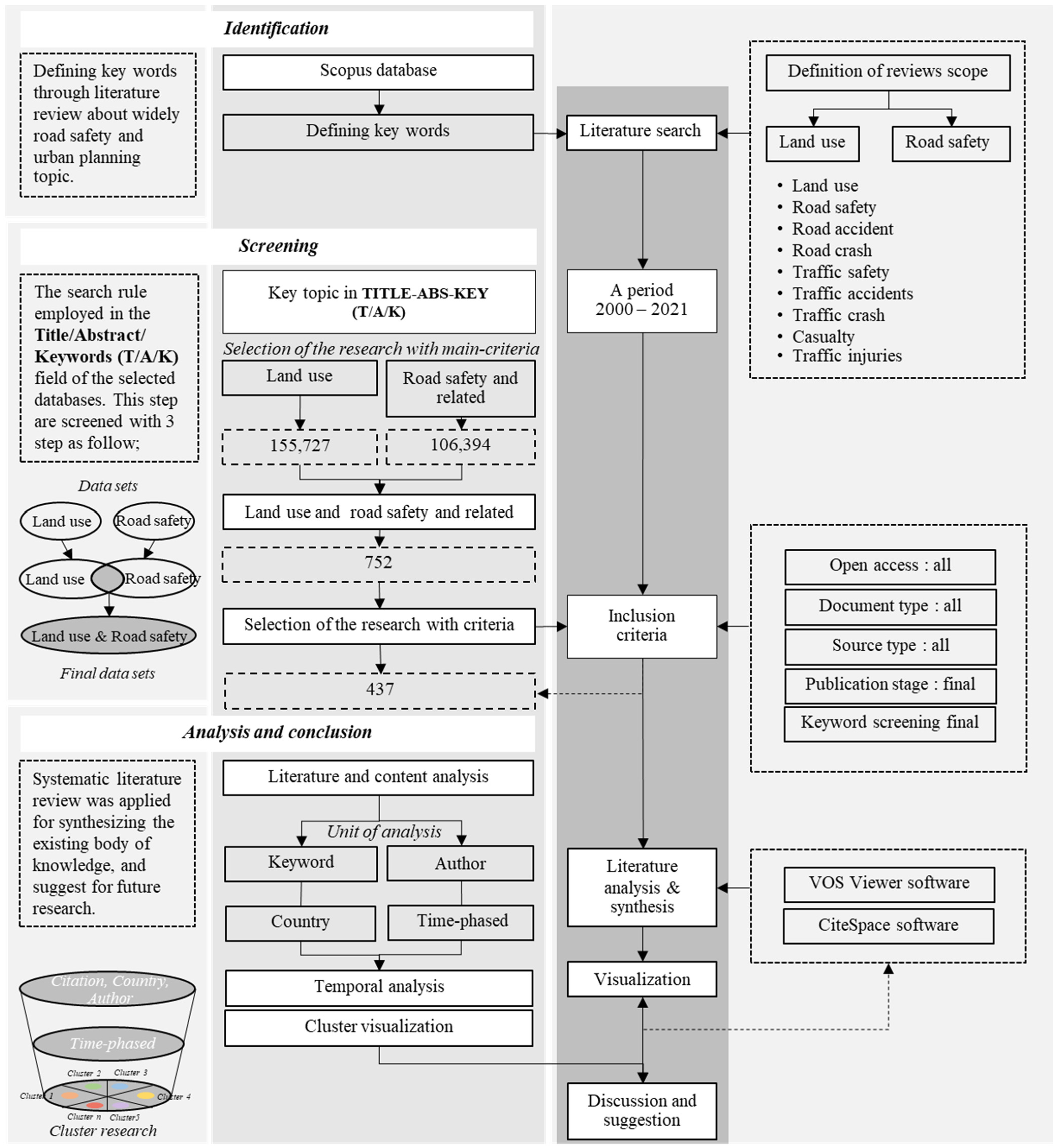
2. Methodology
2.1. Literature Review
2.2. Data Source and Research Process
2.3. Analytical Tool and Visual Examination
3. Results
3.1. Annual Publication Trend and Country of Study (Co-Authorship)
3.2. Term Co-Occurrence Map Based on Text Data (Abstract Field)
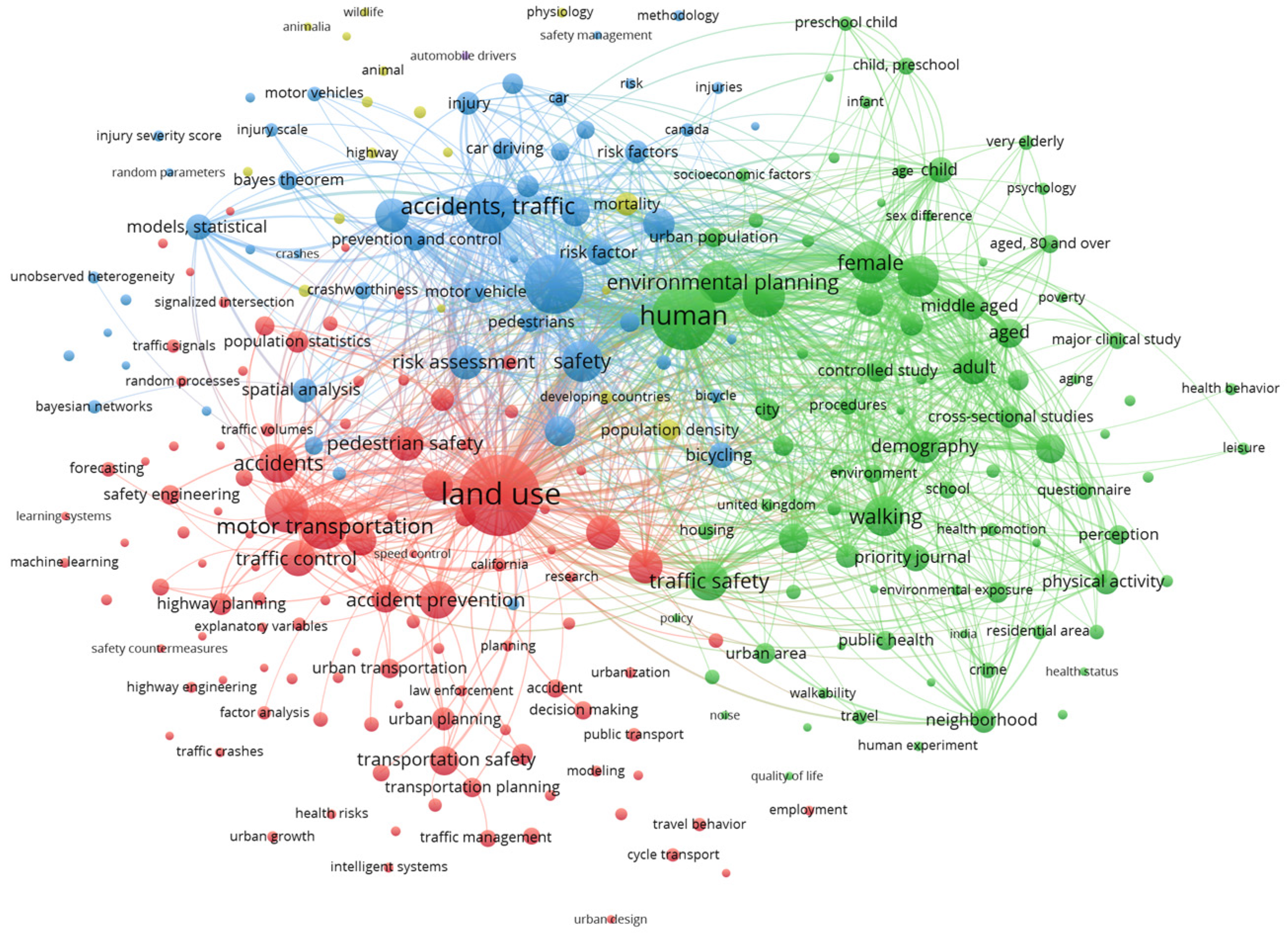
3.3. Publication Performance Analysis with the Keyword Co-Occurrence
- -
- Cluster 1 is about “non-human related accidents” and relates to transportation planning such as animal, environmental, wildlife, etc.
- -
- Cluster 2 relates to “road and environment dimensions” and is described in terms of road and environment factors such as motor transportation, street traffic control, accessibility, safety engineering, spatial analysis, etc.
- -
- Cluster 3 is about “human and vehicle factors (vulnerable group)” and relates to human factors such as people vulnerable (female, children, elderly), vehicle vulnerable (pedestrians, bicycles, motorcycles), etc.
- -
- Cluster 4 is about “land use and transportation planning and approach” and relates to human factors such as land use, urban and rural area, built environment, cluster analysis, decision tree, forecasting, and intelligent system etc.

4. Discussion
5. Conclusions
Author Contributions
Funding
Institutional Review Board Statement
Informed Consent Statement
Data Availability Statement
Acknowledgments
Conflicts of Interest
References
- Statista. Share of Urban Population Worldwide in 2021, by Continent. 2022. Available online: https://www.statista.com/statistics/270860/urbanization-by-continent/ (accessed on 2 April 2022).
- Iamtrakul, P.; Hokao, K. The study of urbanization patterns and their impacts on road safety. Lowl. Technol. Int. 2012, 14, 60–69. [Google Scholar]
- Ammapa, J.; Visuttiporn, P.; Klaylee, J.; Chayphong, S.; Iamtrakul, P. Using GIS-Based Spatial Analysis: Comparing Pattern of Urbanization and Transportation Networks. In Proceedings of the 10th International Conference on Traffic and Logistic Engineering (ICTLE), Macau, China, 12–14 August 2022; pp. 17–21. [Google Scholar] [CrossRef]
- Iamtrakul, P.; Chayphong, S.; Kantavat, P.; Hayashi, Y.; Kijsirikul, B.; Iwahori, Y. Exploring the Spatial Effects of Built Environment on Quality of Life Related Transportation by Integrating GIS and Deep Learning Approaches. Sustainability 2023, 15, 2785. [Google Scholar] [CrossRef]
- Padon, A.; Iamtrakul, P.; Thanapirom, C. The Study of Urbanization Effect on the Land Use Changes and Urban Infrastructures Development in the Metropolitan Areas, Thailand. IOP Conf. Ser. Earth Environ. Sci. 2021, 738, 012077. [Google Scholar] [CrossRef]
- Iamtrakul, P.; Padon, A.; Klaylee, J. Measuring spatializing inequalities of transport accessibility and urban development patterns: Focus on megacity urbanization, Thailand. J. Reg. City Plan. 2022, 33, 345–366. [Google Scholar] [CrossRef]
- Malamis, S.; Katsou, E.; Inglezakis, V.J.; Kershaw, S.; Venetis, D.; Folini, S. Chapter 5—Urban Environment. In Environment and Development; Poulopoulos, S.G., Inglezakis, V.J., Eds.; Elsevier: Amsterdam, The Netherlands, 2016. [Google Scholar] [CrossRef]
- Giuliano, G.; Agarwal, A. Land Use Impacts of Transportation Investments. In The Geography of Urban Transportation, 4th ed.; Giuliano, G., Hanson, S., Eds.; The Guilford Press: New York, NY, USA, 2017. [Google Scholar]
- Åstrøm, A.N.; Moshiro, C.; Hemed, Y.; Heuch, I.; Kvåle, G. Perceived susceptibility to and perceived causes of road traffic injuries in an urban and rural area of Tanzania. Accid. Anal. Prev. 2006, 38, 54–62. [Google Scholar] [CrossRef]
- Liu, T.; Xu, M. Chapter One—Integrated Multilevel Measures for the Transformation to a Transit Metropolis: The Successful and Unsuccessful Practices in Beijing. In Advances in Transport Policy and Planning; Academic Press: Cambridge, MA, USA, 2018; pp. 1–34. [Google Scholar] [CrossRef]
- World Health Organization. World Road Safety Situation Report 2018. 2018. Available online: http://www.who.int/violence_injury_prevention/road_safety_status/2018/GSRRS2018_Summary_Thai.pdf (accessed on 21 March 2022).
- ITF. Road Safety Annual Report 2017; OECD Publishing: Paris, France, 2017.
- Iamtrakul, P.; Chayphong, S.; Makó, E.; Phetoudom, S. Analysis of Road Users’ Risk Behaviors in Different Travel Modes: The Bangkok Metropolitan Region, Thailand. Infrastructures 2023, 8, 79. [Google Scholar] [CrossRef]
- Iamtrakul, P.; Tanaboriboon, Y.; Hokao, K. Analysis of Motorcycle Accidents in Developing Countries: A Case Study of Khon Kaen. Thail. J. East. Asia Soc. Transp. Stud. 2003, 5, 147–162. [Google Scholar]
- Iamtrakul, P.; Chayphong, S. The study of risk behavior factors affecting road accidents. NRRU Community Res. J. 2021, 15, 30–42. [Google Scholar]
- Cantisani, G.; Loprencipe, G.; Primieri, F. The integrated design of urban road intersections: A case study. In Proceedings of the 2012 International Conference on Sustainable Design and Construction, Kansas City, MO, USA, 23–25 March 2012; pp. 722–728. [Google Scholar]
- Chayphong, S.; Iamtrakul, P. Effects of age on urban road traffic accident using GIS: A case study of Bangkok Metropolitan area, Thailand. In Proceedings of the 2nd International Civil Engineering and Architecture Conference, CEAC 2022, Singapore, 11–14 March 2022; Lecture Notes in Civil Engineering. Springer: Singapore. [Google Scholar]
- Iamtrakul, P.; Pimonsathean, P. Impact of urban factors on road accident in Bangkok, Thailand. Lowl. Technol. Int. 2010, 12, 30–40. [Google Scholar]
- Persson, A. Road traffic accidents in Ethiopia: Magnitude, causes and possible interventions. Adv. Transp. Stud. 2008, 15, 5–16. [Google Scholar]
- Bener, A.; Burgut, H.R.; Sidahmed, H.; AlBuz, R.; Sanya, R.; Khan, W.A. Road traffic injuries and risk factors. Calif. J. Health Promot. 2009, 7, 92–101. [Google Scholar] [CrossRef]
- Waseela, M.; Laosee, O. Determinants of Road Traffic Injury Among Adult Motorcyclists in Malé, Maldives. Asia Pac. J. Public Health 2015, 27, 277–285. [Google Scholar] [CrossRef] [PubMed]
- Mooren, L.; Grzebieta, R.; Job, S. Safe system–comparisons of this approach in Australia. In Proceedings of the Australasian College of Road Safety National Conference, Melbourne, Australia, 1–2 September 2011. [Google Scholar]
- IRAP. Forgiving Roads Concept. 2022. Available online: https://toolkit.irap.org/safer-road-treatments/forgiving-roads-concept/ (accessed on 31 March 2022).
- Hummel, T. Land Use Planning in Safer Transportation Network Planning; SWOV: Leidschendam, The Netherlands, 2001. [Google Scholar]
- Levine, N.; Kim, K.; Nitz, L.H. Spatial analysis of Honolulu motor vehicle crashes: II. Zonal generators. Accid. Anal. Prev. 1995, 27, 675–685. [Google Scholar] [CrossRef] [PubMed]
- Ziakopoulos, A.; Yannis, G. A review of spatial approaches in road safety. Accid. Anal. Prev. 2020, 135, 105323. [Google Scholar] [CrossRef] [PubMed]
- Zou, X.; Yue, W.L.; Le Vu, H. Visualization and analysis of mapping knowledge domain of road safety studies. Accid. Anal. Prev. 2018, 118, 131–145. [Google Scholar] [CrossRef]
- Davis, J.; Mengersen, K.; Bennett, S.; Mazerolle, L. Viewing systematic reviews and meta-analysis in social research through different lenses. Springerplus 2014, 3, 511. [Google Scholar] [CrossRef]
- Moher, D.; Liberati, A.; Tetzlaff, J.; Altman, D.G.; PRISMA Group. Preferred Reporting Items for Systematic Reviews and Meta-Analyses: The PRISMA Statement. Ann. Intern. Med. 2009, 151, 264–269. [Google Scholar] [CrossRef]
- PIARC. Land Use and Safety: An Introduction to Understanding How Land Use Decisions Impact Safety of the Transportation System. 2017. Available online: https://www.piarc.org/en/order-library/27270-en-Land%20use%20and%20safety:%20an%20introduction%20to%20understanding%20how%20land%20use%20decisions%20impact%20safety%20of%20the%20transportation%20system (accessed on 27 March 2022).
- Pljakić, M.; Jovanović, D.; Matović, B. The influence of traffic-infrastructure factors on pedestrian accidents at the macro-level: The geographically weighted regression approach. J. Saf. Res. 2022, 83, 248–259. [Google Scholar] [CrossRef]
- Kim, K.; Yamashita, E. Motor Vehicle Crashes and Land Use: Empirical Analysis from Hawaii. Transp. Res. Rec. J. Transp. Res. Board 2002, 1784, 73–79. [Google Scholar] [CrossRef]
- Kim, K.; Brunner, I.M.; Yamashita, E.Y. Influence of land use, population, employment, and economic activity on accidents. Transp. Res. Rec. 2006, 1953, 56–64. [Google Scholar] [CrossRef]
- Kaygisiz, Ö.; Senbil, M.; Yildiz, A. Influence of urban built environment on traffic accidents: The case of Eskisehir (Turkey). Case Stud. Transp. Policy 2017, 5, 306–313. [Google Scholar] [CrossRef]
- Musa, I.J.; Moses, A.O. An analysis of the effect of land use on road traffic accidents in Zaria. Int. J. Dev. Sustain. 2014, 3, 520–529. [Google Scholar]
- Cai, Q.; Abdel-Aty, M.; Sun, Y.; Lee, J.; Yuan, J. Applying a deep learning approach for transportation safety planning by using high-resolution transportation and land use data. Transp. Res. Part A Policy Pract. 2019, 127, 71–85. [Google Scholar] [CrossRef]
- Elias, W.; Shiftan, Y. The safety impact of land use changes resulting from bypass road constructions. J. Transp. Geogr. 2011, 19, 1120–1129. [Google Scholar] [CrossRef]
- Mukherjee, D.; Mitra, S. Impact of Road Infrastructure Land Use and Traffic Operational Characteristics on Pedestrian Fatality Risk: A Case Study of Kolkata, India. Transp. Dev. Econ. 2019, 5, 6. [Google Scholar] [CrossRef]
- Mukoko, K.K.; Pulugurtha, S.S. Examining the influence of network, land use, and demographic characteristics to estimate the number of bicycle-vehicle crashes on urban roads. IATSS Res. 2020, 44, 8–16. [Google Scholar] [CrossRef]
- Effati, M.; Saheli, M.V. Examining the influence of rural land uses and accessibility-related factors to estimate pedestrian safety: The use of GIS and machine learning techniques. Int. J. Transp. Sci. Technol. 2022, 11, 144–157. [Google Scholar] [CrossRef]
- Zhang, Z.; Akinci, B.; Qian, S. Inferring the causal effect of work zones on crashes: Methodology and a case study. Anal. Methods Accid. Res. 2022, 33, 100203. [Google Scholar] [CrossRef]
- Chung, H.; Duan, Q.; Chen, Z.; Yang, Y. Investigating the effects of POI-based land use on traffic accidents in Suzhou Industrial Park, China. Case Stud. Transp. Policy 2023, 12, 100933. [Google Scholar] [CrossRef]
- Goniewicz, K.; Pawłowski, W.; Fiedor, P. Road accident rates: Strategies and programmes for improving road traffic safety. Eur. J. Trauma Emerg. Surg. 2015, 42, 433–438. [Google Scholar] [CrossRef]
- Mendoza, A.E.; Wybourn, C.A.; Mendoza, M.A.; Cruz, M.J.; Juillard, C.J.; Dicker, R.A. The Worldwide Approach to Vision Zero: Implementing Road Safety Strategies to Eliminate Traffic-Related Fatalities. Curr. Trauma Rep. 2017, 3, 104–110. [Google Scholar] [CrossRef]
- Marshall, W.E. Understanding international road safety disparities: Why is Australia so much safer than the United States? Accid. Anal. Prev. 2018, 111, 251–265. [Google Scholar] [CrossRef]
- Crocco, F.; De Marco, S.; Mongelli, D.W.E. An integrated approach for studying the safety of road networks: Logistic regression models between traffic accident occurrence and behavioural, environmental and infrastructure parameters. WIT Trans. Ecol. Environ. 2010, 142, 525–536. [Google Scholar] [CrossRef]
- Safarpour, H.; Khorasani-Zavareh, D.; Mohammadi, R. The common road safety approaches: A scoping review and thematic analysis. Chin. J. Traumatol. 2020, 23, 113–121. [Google Scholar] [CrossRef]
- Goniewicz, K.; Lasota, D. Editorial: Advances in Road Safety Planning. Front. Sustain. Cities 2021, 3, 652953. [Google Scholar] [CrossRef]
- Rey-Martí, A.; Ribeiro-Soriano, D.; Palacios-Marqués, D. A bibliometric analysis of social entrepreneurship. J. Bus. Res. 2016, 69, 1651–1655. [Google Scholar] [CrossRef]
- Small, H. Co-citation in the scientific literature: A new measure of the relationship between two documents. J. Am. Soc. Inf. Sci. 1973, 24, 265–269. [Google Scholar] [CrossRef]
- Albort-Morant, G.; Ribeiro-Soriano, D. A bibliometric analysis of international impact of business incubators. J. Bus. Res. 2016, 69, 1775–1779. [Google Scholar] [CrossRef]
- Xie, L.; Chen, Z.; Wang, H.; Zheng, C.; Jiang, J. Bibliometric and Visualized Analysis of Scientific Publications on Atlantoaxial Spine Surgery Based on Web of Science and VOSviewer. World Neurosurg. 2020, 137, 435–442. [Google Scholar] [CrossRef]
- Ye, Z.; Zhang, B.; Liu, Y.; Zhang, J.; Wang, Z.; Bi, H. A bibliometric investigation of research trends on sulfate removal. Desalination Water Treat. 2014, 52, 6040–6049. [Google Scholar] [CrossRef]
- Sabour, M.R.; Derhamjani, G.; Akbari, M.; Hatami, A.M. Global trends and status in waste foundry sand management research during the years 1971–2020: A systematic analysis. Environ. Sci. Pollut. Res. 2021, 28, 37312–37321. [Google Scholar] [CrossRef] [PubMed]
- Donthu, N.; Kumar, S.; Mukherjee, D.; Pandey, N.; Lim, W.M. How to conduct a bibliometric analysis: An overview and guidelines. J. Bus. Res. 2021, 133, 285–296. [Google Scholar] [CrossRef]
- Zhao, X.; Zuo, J.; Wu, G.; Huang, C. A bibliometric review of green building research 2000–2016. Archit. Sci. Rev. 2019, 62, 74–88. [Google Scholar] [CrossRef]
- Abdullah; Khan, M.N. Determining mobile payment adoption: A systematic literature search and bibliometric analysis. Cogent Bus. Manag. 2021, 8, 1893245. [Google Scholar] [CrossRef]
- Kirby, A. Exploratory Bibliometrics: Using VOSviewer as a Preliminary Research Tool. Publications 2023, 11, 10. [Google Scholar] [CrossRef]
- Nobanee, H.; Al Hamadi, F.Y.; Abdulaziz, F.A.; Abukarsh, L.S.; Alqahtani, A.F.; AlSubaey, S.K.; Alqahtani, S.M.; Almansoori, H.A. A Bibliometric Analysis of Sustainability and Risk Management. Sustainability 2021, 13, 3277. [Google Scholar] [CrossRef]
- Van Eck, N.J.; Waltman, L. Software survey: VOSviewer, a computer program for bibliometric mapping. Scientometrics 2010, 84, 523–538. [Google Scholar] [CrossRef]
- Garcia, I. E-Leadership: A Bibliometric Analysis. Int. J. Adv. Corp. Learn. 2020, 13, 19–34. [Google Scholar] [CrossRef]
- Si, H.; Shi, J.-G.; Wu, G.; Chen, J.; Zhao, X. Mapping the bike sharing research published from 2010 to 2018: A scientometric review. J. Clean. Prod. 2018, 213, 415–427. [Google Scholar]
- Chen, C. CiteSpace II: Detecting and visualizing emerging trends and transient patterns in scientific literature. J. Am. Soc. Inf. Sci. Technol. 2006, 57, 359–377. [Google Scholar] [CrossRef]
- Wei, F.; Grubesic, T.; Bishop, B.W. Exploring the GIS Knowledge Domain Using CiteSpace. Prof. Geogr. 2015, 67, 374–384. [Google Scholar] [CrossRef]
- VOSviewer. Welcome to VOSviewer. 2022. Available online: https://www.vosviewer.com/ (accessed on 25 March 2022).
- Homrich, A.S.; Galvão, G.; Abadia, L.G.; Carvalho, M.M. The circular economy umbrella: Trends and gaps on integrating pathways. J. Clean. Prod. 2018, 175, 525–543. [Google Scholar] [CrossRef]
- Hosseini, M.R.; Martek, I.; Zavadskas, E.K.; Aibinu, A.A.; Arashpour, M.; Chileshe, N. Critical evaluation of off-site construction research: A Scientometric analysis. Autom. Constr. 2018, 87, 235–247. [Google Scholar] [CrossRef]
- Waltman, L.; van Eck, N.J.; Noyons, E.C.M. A unified approach to mapping and clustering of bibliometric networks. J. Informetr. 2010, 4, 629–635. [Google Scholar] [CrossRef]
- Baier-Fuentes, H.; Merigó, J.M.; Amorós, J.E.; Gaviria-Marín, M. International entrepreneurship: A bibliometric overview. Int. Entrep. Manag. J. 2019, 15, 385–429. [Google Scholar] [CrossRef]
- Hudha, M.N.; Hamidah, I.; Permanasari, A.; Abdullah, A.G.; Rachman, I.; Matsumoto, T. Low Carbon Education: A Review and Bibliometric Analysis. Eur. J. Educ. Res. 2020, 9, 319–329. [Google Scholar] [CrossRef]
- Meng, L.; Wen, K.-H.; Brewin, R.; Wu, Q. Knowledge Atlas on the Relationship between Urban Street Space and Residents’ Health—A Bibliometric Analysis Based on VOSviewer and CiteSpace. Sustainability 2020, 12, 2384. [Google Scholar] [CrossRef]
- Cardona, G.; Sanz, J. Publication Analysis of the Contact Lens Field: What are the Current Topics of Interest? J. Optom. 2015, 8, 33–39. [Google Scholar]
- Acedo, F.J.; Barroso, C.; Casanueva, C.; Galan, J.L. Co-Authorship in Management and Organizational Studies: An Empirical and Network Analysis. J. Manag. Stud. 2006, 43, 957–983. [Google Scholar] [CrossRef]
- Cisneros, L.; Ibanescu, M.; Keen, C.; Lobato-Calleros, O.; Niebla-Zatarain, J. Bibliometric study of family business succession between 1939 and 2017: Mapping and analyzing authors’ networks. Scientometrics 2018, 117, 919–951. [Google Scholar] [CrossRef]
- World Health Organizations. Road Traffic Injuries. 2022. Available online: https://www.who.int/health-topics/road-safety#tab=tab_1 (accessed on 2 April 2022).
- Jaarsma, C.F. Rural low-traffic roads (LTRs): The challenge for improvement of traffic safety for all road users. In Proceedings of the 27th ISATA, Dedicated Conference on Road and Vehicle Safety, Aachen, Germany, 31 October–4 November 1994; pp. 177–183. [Google Scholar]
- World Health Organizations. The Decade of Action for Road Safety 2021–2030. 2021. Available online: https://www.who.int/teams/social-determinants-of-health/safety-and-mobility/decade-of-action-for-road-safety-2021–2030 (accessed on 2 April 2022).
- World Road Association (PIARC). Road Safety Manual: A Manual for Practitioners and Decision Makers on Implementing Safe System Infrastructure; World Road Association (PIARC): London, UK, 2015. [Google Scholar]
- Organisation for Economic Co-Operation and Development (OECD). Towards Zero. Ambitious Road Safety Targets and the Safe System Approach; Organisation for Economic Co-Operation and Development: Paris, France, 2008; 242p.
- Mateo-Babiano, I.; Ieda, H. Theoretical discourse on sustainable space design: Towards creating and sustaining effective sidewalks. Bus. Strat. Environ. 2005, 14, 300–314. [Google Scholar] [CrossRef]
- Mateo-Babiano, I. Pedestrian’s needs matter: Examining Manila’s walking environment. Transp. Policy 2016, 45, 107–115. [Google Scholar] [CrossRef]
- Stevenson, M.; Thompson, J.; de Sá, T.H.; Ewing, R.; Mohan, D.; McClure, R.; Roberts, I.; Tiwari, G.; Giles-Corti, B.; Sun, X.; et al. Land use, transport, and population health: Estimating the health benefits of compact cities. Lancet 2016, 388, 2925–2935. [Google Scholar] [CrossRef] [PubMed]
- Iamtrakul, P.; Chayphong, S.; Klaylee, J. Foreign tourist behavior and perception of motorcycle accident risk in Chiang Mai, Thailand. Lowl. Technol. Int. 2019, 21, 187–196. [Google Scholar]
- Glendon, A.I.; McNally, B.; Jarvis, A.; Chalmers, S.L.; Salisbury, R.L. Evaluating a novice driver and pre-driver road safety intervention. Accid. Anal. Prev. 2014, 64, 100–110. [Google Scholar] [CrossRef]
- Useche, S.A.; Montoro, L.; Alonso, F.; Tortosa, F.M. Does gender really matter? A structural equation model to explain risky and positive cycling behaviors. Accid. Anal. Prev. 2018, 118, 86–95. [Google Scholar] [CrossRef]
- Kelley-Baker, T.; Romano, E. Female involvement in U.S. nonfatal crashes under a three-level hierarchical crash model. Accid. Anal. Prev. 2010, 42, 2007–2012. [Google Scholar] [CrossRef]
- Cordellieri, P.; Baralla, F.; Ferlazzo, F.; Sgalla, R.; Piccardi, L.; Giannini, A.M. Gender Effects in Young Road Users on Road Safety Attitudes, Behaviors and Risk Perception. Front. Psychol. 2016, 7, 1412. [Google Scholar] [CrossRef]
- Yilmaz, V.; Çelik, H.E. Risky Driving Attitudes and Self-Reported Traffic Violations among Turkish Drivers: The Case of Eskişehir. 2006. Available online: http://openaccess.dogus.edu.tr/bitstream/handle/11376/427/yilmaz.pdf?sequence= (accessed on 1 April 2022).
- Varmazyar, S.; Mortazavi, S.B.; Hajizadeh, E.; Arghami, S. The Relationship Between Driving Aberrant Behavior and Self-Reported Accidents Involvement Amongst Professional Bus Drivers in the Public Transportation Company. Health Scope 2013, 2, 110–115. [Google Scholar] [CrossRef]
- National Road Safety Strategy, 2021. Fact Sheet: Vulnerable Road Users. Available online: https://www.roadsafety.gov.au/nrss/fact-sheets/vulnerable-road-users (accessed on 5 April 2022).
- Khayesi, M. Vulnerable Road Users or Vulnerable Transport Planning? Front. Sustain. Cities 2020, 2, 25. [Google Scholar] [CrossRef]
- Mohan, D. Vulnerable road users: An era of neglect. Traffic Med. 1992, 20, 121–128. [Google Scholar]
- OECD. Safety of Vulnerable Road Users; Organisation for Economic Co-Operation and Development: Paris, France, 1998. [Google Scholar]
- PIARC. Safety of Vulnerable Road Users. 2020. Available online: https://rnoits.piarc.org/en/network-operations-its-road-safety/vulnerable-road-users (accessed on 5 April 2022).
- Tiwari, G. Safety of ‘the vulnerable road users’: Current challenges and need for a new approach. Int. J. Inj. Control. Saf. Promot. 2018, 25, 1429211. [Google Scholar] [CrossRef]
- European Transport Safety Council. How Safe is Walking and Cycling in Europe? PIN Flash Report 38; European Transport Safety Council: Brussels, Belgium, 2020. [Google Scholar]
- Tomaszewska, E.J.; Florea, A. Urban smart mobility in the scientific literature—Bibliometric analysis. Eng. Manag. Prod. Serv. 2018, 10, 41–56. [Google Scholar] [CrossRef]
- Bitam, S.; Mellouk, A. ITS-cloud: Cloud computing for Intelligent transportation system. In Proceedings of the 2012 IEEE Global Communications Conference (GLOBECOM), Anaheim, CA, USA, 3–7 December 2012; pp. 2054–2059. [Google Scholar] [CrossRef]
- Haddon, W. The changing approach to the epidemiology, prevention, and amelioration of trauma: The transition to approaches etiologically rather than descriptively based. Inj. Prev. 1999, 5, 231–235. [Google Scholar] [CrossRef]
- Santacreu, A. Safer City Streets Global Benchmarking for Urban Road Safety; International Transport Forum Working Document; OECD Publishing: Paris, France, 2018. [Google Scholar]
- Minister of Transport. Traffic in Towns: A Study of the Long Term Problems of Traffic in Urban Areas; Buchanan report; HMSO: London, UK, 1963.
- Shen, L.; Sun, W.; Parida, V. Consolidating digital servitization research: A systematic review, integrative framework, and future research directions. Technol. Forecast. Soc. Change 2023, 191, 122478. [Google Scholar] [CrossRef]
- Berthod, C. Land use planning measures promoting road safety. In New Research and Developments in Road Safety Session of the 2016 Conference of the Transportation Association of Canada, Toronto; Transportation Association of Canada (TAC): Ottawa, ON, Canada, 2016. [Google Scholar]


| Rank | Country | Documents (Quantity) | Percentage | Total Link Strength |
|---|---|---|---|---|
| 1 | United States | 163 | 26.46 | 126 |
| 2 | China | 63 | 10.23 | 43 |
| 3 | Canada | 47 | 7.63 | 37 |
| 4 | Australia | 38 | 6.17 | 78 |
| 5 | United Kingdom | 34 | 5.52 | 27 |
| 6 | India | 18 | 2.92 | 23 |
| 7 | Hong kong | 17 | 2.76 | 61 |
| 8 | Germany | 12 | 1.95 | 8 |
| 9 | Japan | 11 | 1.79 | 55 |
| 10 | Netherlands | 11 | 1.79 | 19 |
| Citations | Title | Authors | Year |
|---|---|---|---|
| 307 | Residents’ perceptions of walkability attributes in objectively different neighborhoods: A pilot study | Leslie E., Saelens B., Frank L., Owen N., Bauman A., Coffee N., Hugo G. | 2005 |
| 295 | Land use, transport, and population health: estimating the health benefits of compact cities | Stevenson M., Thompson J., de Sá T.H., Ewing R., Mohan D., McClure R., Roberts I., Tiwari G., Giles-Corti B., Sun X., Wallace M., Woodcock J. | 2016 |
| 259 | An area-level model of vehicle-pedestrian injury collisions with implications for land use and transportation planning | Wier M., Weintraub J., Humphreys E.H., Seto E., Bhatia R. | 2009 |
| 248 | Toward safer highways, application of XGBoost and SHAP for real-time accident detection and feature analysis | Parsa A.B., Movahedi A., Taghipour H., Derrible S., Mohammadian A.K. | 2020 |
| 221 | The urban built environment and mobility in older adults: A comprehensive review | Rosso A.L., Auchincloss A.H., Michael Y.L. | 2011 |
| 220 | Neighborhood Environment Walkability Scale for Youth (NEWS-Y): Reliability and relationship with physical activity | Rosenberg D., Ding D., Sallis J.F., Kerr J., Norman G.J., Durant N., Harris S.K., Saelens B.E. | 2009 |
| 199 | The link between the built environment, pedestrian activity and pedestrian-vehicle collision occurrence at signalized intersections | Miranda-Moreno L.F., Morency P., El-Geneidy A.M. | 2011 |
| 198 | A spatially disaggregate analysis of road casualties in England | Noland R.B., Quddus M.A. | 2004 |
| 177 | GIS measured environmental correlates of active school transport: A systematic review of 14 studies | Wong B.Y.-M., Faulkner G., Buliung R. | 2011 |
| 177 | Walkability and safety around elementary schools: Economic and ethnic disparities | Zhu X., Lee C. | 2008 |
| Rank | Index Keyword | Occurrences | Total Link Strength | Author Keyword | Occurrences | Total Link Strength |
|---|---|---|---|---|---|---|
| 1 | Land use | 251 | 3940 | Built environment | 47 | 47 |
| 2 | Human | 168 | 3755 | Land use | 33 | 28 |
| 3 | Traffic accident | 141 | 3019 | Road safety | 29 | 15 |
| 4 | Accidents, traffic | 113 | 2500 | Traffic safety | 24 | 18 |
| 5 | Motor transportation | 95 | 1262 | Physical activity | 18 | 22 |
| 6 | Roads and streets | 81 | 1127 | GIS | 15 | 20 |
| 7 | Environment design | 80 | 1953 | Safety | 15 | 22 |
| 8 | Environmental planning | 79 | 1888 | Walkability | 15 | 22 |
| 9 | Safety | 74 | 1681 | Pedestrian safety | 12 | 12 |
| 10 | Walking | 71 | 1649 | Spatial analysis | 10 | 10 |
Disclaimer/Publisher’s Note: The statements, opinions and data contained in all publications are solely those of the individual author(s) and contributor(s) and not of MDPI and/or the editor(s). MDPI and/or the editor(s) disclaim responsibility for any injury to people or property resulting from any ideas, methods, instructions or products referred to in the content. |
© 2023 by the authors. Licensee MDPI, Basel, Switzerland. This article is an open access article distributed under the terms and conditions of the Creative Commons Attribution (CC BY) license (https://creativecommons.org/licenses/by/4.0/).
Share and Cite
Iamtrakul, P.; Chayphong, S.; Mateo-Babiano, D. The Transition of Land Use and Road Safety Studies: A Systematic Literature Review (2000–2021). Sustainability 2023, 15, 8894. https://doi.org/10.3390/su15118894
Iamtrakul P, Chayphong S, Mateo-Babiano D. The Transition of Land Use and Road Safety Studies: A Systematic Literature Review (2000–2021). Sustainability. 2023; 15(11):8894. https://doi.org/10.3390/su15118894
Chicago/Turabian StyleIamtrakul, Pawinee, Sararad Chayphong, and Derlie Mateo-Babiano. 2023. "The Transition of Land Use and Road Safety Studies: A Systematic Literature Review (2000–2021)" Sustainability 15, no. 11: 8894. https://doi.org/10.3390/su15118894