Article

Potential of an Area in Terms of Pro-Climate Solutions in a Land Consolidation Project

1
Faculty of Geoengineering, University of Warmia and Mazury in Olsztyn, 10-719 Olsztyn, Poland
2
Department of Land Surveying, University of Agriculture in Krakow, 31-120 Krakow, Poland
3
Faculty of Geodesy and Geotechnics, Rzeszow University of Technology, 35-959 Rzeszów, Poland
4
Faculty of Civil and Transport Engineering, Poznan University of Technology, 60-965 Poznań, Poland
*
Author to whom correspondence should be addressed.
Sustainability 2023, 15(12), 9306; https://doi.org/10.3390/su15129306
Submission received: 1 April 2023 / Revised: 29 May 2023 / Accepted: 5 June 2023 / Published: 8 June 2023

Abstract

:
Land consolidation plays an important role in promoting changes in agricultural land use and ensuring national food security. Moreover, it allows the land structure in rural areas to be built anew. By changing the spatial structure of the countryside, it is also possible to implement water and drainage measures as well as ecological and landscape measures aimed at improving farming conditions. At the same time, they have an impact on the climate. This study analysed the potential for the implementation of pro-climate solutions that can be applied when implementing a land consolidation project in terms of reducing wind speed, increasing humidity, and affecting carbon dioxide reduction. The analyses used an indicator of the potential for implementing pro-climate solutions based on an overall synthetic index taking into account 11 attributes. The results show that the micro-location potential in the context of the possibility of applying pro-climate solutions is not homogenous. It is affected, e.g., by the soil quality, the state of farming culture of the land in agricultural use, the resource and advancement of natural landscape components, and the local needs of agricultural producers to introduce environmental solutions that will simultaneously have a positive impact on farming conditions. According to research, peri-tree land can cluster, meaning that its character represents a spatial continuity. During the land consolidation process, this continuity should be preserved, especially in areas with inferior soil quality.

1. Introduction

The rapid progress of urbanisation that took place in the last century has resulted in the conversion of natural and semi-natural land to non-agricultural use and soil degradation. These processes are most probably among the factors suspected of affecting the climate. The climate challenge is currently a major civilisational challenge facing humanity [1]. The implementation of mitigation and adaptation measures has become the highest priority, as they pose a challenge to a wide range of human activities. The major sources of greenhouse gas emissions, which are mainly responsible for climate change, include the combustion of fossil fuels and changes in land use [2,3], the conversion of forests into agricultural land, and the conversion of semi-natural land into urbanised (built-up, paved, etc.) land [4]. According to Boatenga et al. [5], the change in land use from forest to agricultural land is responsible for more than 30% of all greenhouse gas emissions.
By managing ecosystems (primarily terrestrial ones), we can have a significant impact on the climate. Anthropogenic mitigation measures concerning climate should involve reducing the emissions of greenhouse gases generated during agricultural production, as well as limiting land use changes and enhancing carbon sequestration in ecosystems. Nature-based actions also include adaptation, i.e., reducing the vulnerability of ecosystems, including the anthroposphere, e.g., through shaping water retention and local water circulation and changing the agricultural and forestry cultivation practices [6,7,8].
The creation of conditions favouring the implementation of climate protection measures can be applied during the land consolidation process. The term “land consolidation” first appeared in Germany in 1343 and was subsequently used in the Netherlands, Russia, and other countries [9,10,11,12]. Different countries or regions have different terms for this concept, e.g., “land improvement” in Japan and “agricultural land redrawing” in China, but their essence and the main content are more or less the same [12,13]. Land consolidation is traditionally defined as a planned correction and reorganisation of land parcels and their ownership, to solve the land fragmentation problem [10,11,12,13,14]. The objectives, tasks, requirements, and models of land consolidation have changed with the development of the economy and society. Currently, land consolidation is no longer a simple redesign of parcel boundaries to eliminate the effects of land fragmentation but is closely linked to socio-economic changes. The headline target of land consolidation has changed. This evolution has mainly involved a shift from the quantitative conversion of agricultural land, aimed at increasing the area under cultivation and enhancing food security, to comprehensive management of the ecological environment and village culture [11,15,16]. Therefore, land consolidation has become a tool for shaping the space of rural areas, as it has enabled their comprehensive modification, which is impossible achieve using a buy-out, expropriation, or other legal and technical interventions [17,18,19,20]. As a result of land consolidation, agricultural producers gain a modern space for working and living [21,22]. The space is shaped in such a manner that, with its impact on the biological, ecological [23], and climatic environment (in terms of reducing wind speed, increasing humidity, and affecting carbon dioxide reduction), it can comprehensively solve water-related problems, particularly those associated with periodic water scarcity or excess, as well as problems with contaminated and degraded land [24,25,26,27], and wind and erosion protection facilities for agricultural land [28,29]. This can be achieved through (a) the renaturalisation of water courses; (b) establishing shelter belts, planting trees in fields and along roads, and creating buffer vegetation strips between rivers and fields under cultivation; (c) establishing the field–forest boundary and the so-called field margins; (d) supporting the establishment of ecological corridors using afforestation, land reclamation, and the establishment of woodlots; (e) introducing land turfing to effectively prevent soil erosion; (f) restoring drainage ditches and constructing storage reservoirs; and (g) improving the course and technical quality of agricultural transport roads (the so-called rural roads).
This study aims to assess the potential of the area for the application of pro-climate solutions in ten villages (Brochocin, Grodziec, Jadwisin, Łukaszów, Modlikowice, Olszanica, Radziechów, Uniejowice, Wojciechów, Zagrodno) located in commune Zagrodno, Dolnośląskie Voivodeship, Poland. The implementation of the main research objective was based on three detailed hypotheses objectives: (1) in the land consolidation project, it is possible to implement solutions that affect the climate in terms of reducing wind speed, reducing carbon dioxide, and improving air humidity; (2) pro-climate solutions increase the landscape values of the consolidation area; and (3) micro-locations have a diverse potential for the application of pro-climate solutions.
The valuation was carried out based on a field inventory and the maps published on the national geoportal, which provides maps in the OGC (Open Geospatial Consortium) standard.

2. Literature Review

2.1. Renaturalisation of Watercourses

During land consolidation, zones are established to restore the natural course of water courses and the retention of water in wetland and marshy areas [30]. They enable a reduction in the water runoff rate, contribute to prolonging water circulation in the landscape, and prevent deformative changes in river hydrography and hydrology. Scientific research provides ample evidence that global warming will probably be linked to a rapid increase in flood risk [31]. Rivers are complex socio-economic systems, as humans interact with rivers in different ways [32,33]. River engineering adversely affects both ecology and the environment, which is due to the impermeable materials used, which reduce stormwater resistance in riparian zones and require the construction of infrastructure to increase rainwater flow capacity. Physical changes to river banks and riverside land can exacerbate structural changes in ecological regimes (these include, e.g., hydrogeological environment’s source capacity, hydrostatic pressure, the chemical composition of water, and its physical properties) [34]. Artificial modification of hydrological systems also significantly reduces the resilience of natural water bodies to anthropogenic pollution [35]. Renaturalisation of rivers improves the natural values and riverside ecological conditions, promotes a high-quality environment, and, above all, builds resilience to climate change [33,36,37,38].
The establishment of natural floodplain areas along water courses, renaturalisation of rivers, and irrigation and drainage measures directly contribute to the improvement of moisture conditions on fields under cultivation and meadows in wet years, extend the growing season by accelerating field work by 2–3 weeks (quicker drying of the ground after spring snowmelt), provide plants with water during periods of its shortage, support the restoration of natural plant–soil retention, and contribute to raising the groundwater level [31,32,33,34,35,36,37,38,39,40,41,42].

2.2. Shelter Belts, Woodlots, Afforestation, Roadside Tree Clumps, Buffer Vegetation Strips between a River and a Field under Cultivation

The design of spaces intended for shelter belts, hedgerows [43,44], buffer vegetation strips between a river and a field under cultivation [27,28], and woodlots with canopy vegetation (see Figure 1) represent further pro-environmental and pro-climate measures implemented in the land consolidation project. These natural objects retain water, provide habitats for biodiversity, maintain landscape continuity, and reduce wind speed, thus minimising wind erosion. Shelter belts help control erosion and snowstorms, improve the health and survival of animals in winter conditions, reduce the energy intensity of a farm unit (including buildings), and increase the diversity of habitats to provide shelter for birds of prey and insects. At the macro-scale, shelter belts provide habitats for various wild animal and plant species and have the potential to bring significant benefits to the carbon balance equation, thus reducing the economic burden associated with climate change [45,46,47,48,49,50,51,52,53]. Moreover, shelter belts reduce wind speed and change wind turbulence, thus altering the microclimate in the sheltered zone [54,55,56,57,58,59,60].

2.3. Field–Forest Boundary, Field Margin

Marginal habitats found on the forest–field boundary and field edges contribute to the maintenance of biodiversity in agricultural landscapes and provide habitats for numerous plant species [61,62,63,64,65,66] (see Figure 1). This affects the microclimatic and soil conditions for trees, bushes, and other species of plants growing nearby at the field level [67,68,69,70,71,72]. Therefore, such zones are being incorporated into the land consolidation project.

2.4. Ecological Corridors, Afforestation, and Land Reclamation

The establishment of ecological corridors is a strategy for adapting biodiversity to climate change [69,73,74,75]. Ecological corridors are areas that allow plants and animals to migrate between habitats (see Figure 1). Thanks to these spaces, many species can exist despite adverse environmental changes. As a result, European habitats are characterised by high biodiversity. During land consolidation, the functioning of ecological corridors is supported by the creation of natural environmental components, including artificial afforestation, woodlots, or turfing, and also land reclamation, thus enabling the smooth, natural flow of genes between habitats. It is particularly important to prevent the conversion of grassland into arable land under plough tillage, as this results in the landscape becoming fragmented, which hinders interspecies migration. Moreover, these objects positively support the planet’s carbon budget [76,77,78].

2.5. Anti-Erosion Turfing

The impact of erosion in agroecosystems is manifested by an adverse transformation of natural conditions. These changes are often permanent and affect the topography, soil, water relations, natural vegetation, technical infrastructure, and ecological and landscape assets (see Figure 1). This multi-faceted impact of erosion often results in biological imbalance and, consequently, reduced soil fertility. The damage potential of erosion also involves a reduction in the water retention of soils, i.e., the ability to store water and minerals. In addition to reducing the leaching of soil particles and nutrients, the protection of soils against erosion also promotes the protection of waters against other nutrients, e.g., nitrogen and phosphorus [79]. The impact of this phenomenon can be significantly reduced by the introduction of turfing into the agricultural space. The root system of plants is complex, and understanding the interactions between the soil and the roots is difficult [80]. According to Gyssels et al. [81], the decrease in water erosion rate increases exponentially following the introduction of grasses. The roots serve as the main interface between the plant and different biotic and abiotic factors in the soil environment [82,83,84,85]. Grassland management practices have a broad anti-erosion effect. Lucerne-containing permanent grassland and temporary swards protect hillsides against water by preventing or reducing erosion. In addition, turfing contributes to the cooling of heat islands, water storage, increasing biodiversity, and enhancing carbon dioxide sequestration.

2.6. Drainage Ditches, Storage Reservoirs

Drainage ditches can drain excess water from the soil and can also be used for irrigation. When implementing a land consolidation project, this infrastructural object is subject to analysis in terms of interaction with agroecosystems (see Figure 1). Drainage ditches are subject to expansion, closure, or blockage removal. In the context of climate change occurring in the environment, a network of drainage ditches can support the removal of rainwater from the field, thus allowing tractors to enter the field earlier to carry out fieldwork. However, in peat areas, the expansion of ditches or blockage removal may contribute to their excessive drying, which consequently makes them vulnerable to fires (particularly in forests). Therefore, each decision to expand or close drainage ditches or to remove their blockages should be taken based on a detailed assessment of the local hydrographic situation.
Storage reservoirs [86,87,88], similar to drainage ditches, serve a key role in a period of extremely dynamic climate change. On the one hand, they are able to store water and slow down its runoff. On the other hand, they help avoid flooding in the event of increased precipitation, thus preventing multi-million financial losses. The water stored in the reservoirs can be used for irrigation in times of drought and also for recreation, as in the case of natural water bodies [86,87,88,89,90,91]. Storage reservoirs also improve the aesthetic value of urbanised areas and have a beneficial effect on the local microclimate and biodiversity.

2.7. Agricultural Transport Roads

Agricultural transport roads (rural roads) include the entire infrastructure used to move between fields under cultivation or between the farm premises and a field under cultivation. These include access roads, tertiary roads, low-capacity rural roads, local roads, and lower-class roads [92,93,94]. In Poland, the roads on which agricultural machines move are referred to as agricultural transport roads. These can be roads classified as district roads (owned by local district (poviat) government), local roads (owned by local commune government), and internal roads (classified in none of these categories) or private roads. Despite the diverse classification of rural roads, depending on the context, they all share common characteristics: limited traffic volumes [95], low travel speeds [96], and limited engineering levels (sealing and drainage) [96]. Moving on such roads affects the climate, but also the climate and its changes affect the technical condition of rural roads; in particular, their quality in terms of pavement durability. The selection of the location of roads that should be subject to pavement improvement through the use of suitable materials contributes to the prevention of land marginalisation as well as the quality of life of the rural communities using these roads (see Figure 1). Poorly surfaced roads contribute to increased exhaust emissions, vibrations, and noise (agricultural machines move more slowly, and the operator has to perform more manoeuvres) and are also involved in the formation of land erosion on fields under cultivation adjacent to the road, in the absence of water drainage from the road [83,84,85,97].

2.8. Land Consolidation in Poland

The history of land consolidation of Polish lands dates back to the beginning of the 19th century. It was carried out first in the Prussian sector of the formerly partitioned Poland (according to the Land Consolidation Laws of 1821 and 1823), along with the enfranchisement of peasant farms [98,99,100,101,102]. According to data from 1921, during the interwar period in Poland (between the First and the Second World War), the patchwork of the land concerned approximately 1.5 million farms with a total area of 10–11 million ha [100]. In the following period, how land consolidation was implemented was governed by the (repeatedly amended) Act of 1923. In the years 1919–1938, land consolidation covered 859,000 farms with an area of 5.4 million ha [98,99,100,101,102]. After the Second World War, land consolidation was subordinated to the needs of farms nationalised by the Decree of 1949 [101,102]. After the liberation of Poland, until 1948, 372,800 ha of land in the areas not completed in the interwar period were consolidated [101,102]. The Act of 1968 provided more favourable conditions for land consolidation in peasant farms, but individual farms were not consolidated at that time. In the years 1968–1980, land consolidation covered approximately 750,000 farms with an area of 4.5 million ha. However, numerous irregularities in its implementation triggered negative attitudes among rural inhabitants [98,99,100,101,102]. The liberalised Act of 1982 failed to bring about the desired changes, and the land consolidation rates in the years 1982–1988 slowed down considerably. Based on the act, 42,529 ha of land were consolidated in 1983 [98,99,100,101,102]. From 1992 onwards, there was a sharp decrease in land consolidation projects being implemented, continuing in subsequent years. It was only after Poland’s accession to the European Union structures that the urgent need for land consolidation was again recognised, although the extent of its implementation was not as impressive as it was in the 1960s.
There are various types of land consolidation. For example, land consolidation that eliminates checkerboard land, drainage-road consolidation to improve transportation in the consolidation area, anti-erosion land consolidation, landscape land consolidation, or infrastructure land consolidation that repairs the use structure after highway construction. Nowadays, the predominant objective of land consolidation is to separate new parcels in such a manner as to eliminate their excessive dispersion and improve their technical parameters [9,10,11]. The construction of a functional network of access roads to agricultural and forest land, the performance of tasks affecting the regulation of water relations in the area subject to consolidation, and the adaptation of parcels to the topography [18,103,104] became equivalent objectives two decades ago, after Poland’s accession to the European Union structures. Over the years, the prevailing technical objectives have evolved towards a greater emphasis on taking environmental determinants into account when separating new parcels and carrying out agricultural production by local conditions. This new concept of land consolidation has provided conditions for searching for equilibrium between human needs associated with food production and interference with the natural environment.
Land consolidation works in Poland are much needed and are increasingly popular in rural communities, especially those which have become familiar with the effects of land consolidation works completed in other locations. Dissemination of the multi-faceted benefits of land consolidation can contribute to the spread and application of pro-environmental measures in Polish villages as well as initiatives favouring climate change adaptation.
Previous research into land consolidation mainly focused on the effects of land consolidation on crop productivity, technical efficiency, arable land layout, and landscape types [105,106,107,108,109,110], the effects of land consolidation policy, reforms, and land fragmentation [18,105,107,110] on ecosystem services through land use change in the context of accelerated urbanisation [107,111], and the assessment of the benefits of land consolidation in economic, social, and ecological terms [107]. Environmental quality in land consolidation projects is a very important research trend. Authors of the studies use various indicators, criteria, and scales to assess ecological environmental quality, including the Analytic Hierarchy Process (AHP) [112,113], the environmental index (EI) [113], and remote sensing data [4,114,115,116]. Moreover, an analysis of ecological sensitivity in land consolidation projects was also proposed [117]. Most of the analysed studies focused on the environmental impact of land consolidation projects. Few studies have addressed the problem of the possibility/potential of an area/spatial unit for implementing pro-environmental/pro-climate solutions. The location where a new land consolidation project should be implemented can have strictly spatial and organisational problems (e.g., related to the inappropriate distribution of agricultural parcels, too small parcels, inability to access a parcel using a public/internal road or to move on the section of the field in agricultural use, or inability to develop other functions than the agricultural one due to parcels being excessively elongated so that buildings are built along the road, inability to arrange the second and third row of buildings), or environmental and spatial problems (apart from defects of the land in terms of work organisation, there are objects/natural spaces left without human supervision, which has affected their development). The projects assessed by representatives of environmental agencies have the task of verifying whether the object (in its new solution) will have a beneficial/adverse impact on the natural environment. The compensations planned in land consolidation projects are expected to reduce the adverse effects of the newly designed parcel boundaries, roads, drainage ditches, etc. However, each area/space has a different potential for the implementation of new pro-climate solutions. Locations vary in terms of the type and surface area of the natural landscape and environmental elements. The free meandering of rivers, the formation of depressions and isolated still water bodies, etc., do not always have the possibility of being formed as the owners/users/agricultural producers preemptively act to prevent their formation.

3. Materials and Methods

3.1. Study Area

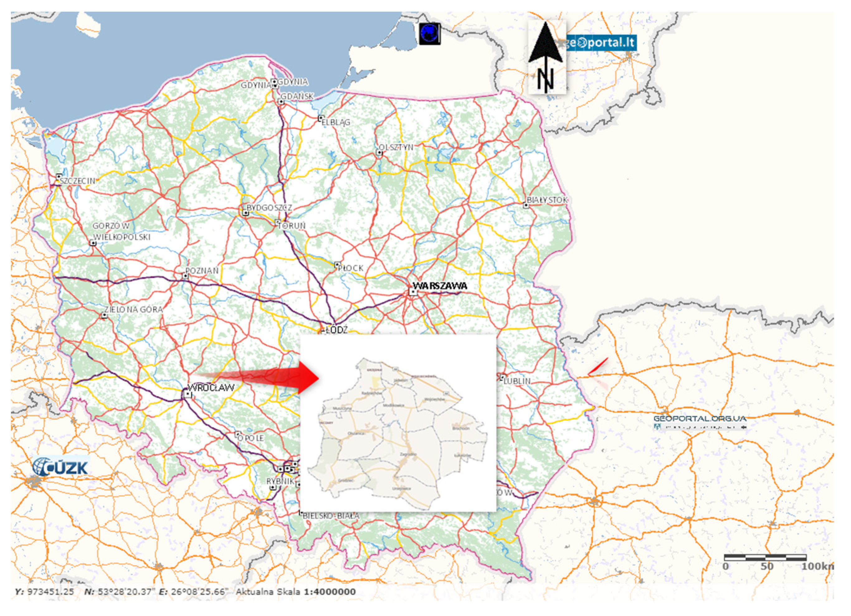
Studies and analyses were carried out for villages located in the commune of Zagrodno, Dolnośląskie Voivodeship, Poland. The commune of Zagrodno is located approximately 90 km north of Wrocław, in the immediate vicinity of the commune of Złotoryja, and is part of the Złotoryjski Poviat. It covers an area of 122.34 km2 [117]. Agricultural land occupies 83% of the area, while forested land occupies 9%. The population is 5695, and the population density is 44 inhabitants per km2. The commune area accounts for 21.22% of the poviat area. There are ten villages located within the administrative boundaries of the commune: Brochocin (A), Grodziec (B), Jadwisin (C), Łukaszów (D), Modlikowice (E), Olszanica (F), Radziechów (G), Uniejowice (H), Wojciechów (I), and Zagrodno (J). The area of the commune is crossed by the A4 motorway, a national road, a regional road, and a railway line.
The commune of Zagrodno is a commune with high agricultural productivity. It is a typically agricultural commune and has a large economic potential in this regard. The total length of the river network in the commune is 37.58 km. Flowing waters, along with drainage ditches, cover an area of 76.38 ha, which accounts for 0.6% of the commune area. The Skora River, which flows meridionally through the central part of the commune, divides its area into eastern and western parts. It is mountainous in character and is distinguished by large changes in water levels depending on the amount of precipitation, which results in periodic flooding of adjacent areas. Figure 2 shows the location of the land under analysis.

3.2. Methodology

3.2.1. Construction of Pro-climatic Index

This study analysed the potential of the area for the implementation of pro-climate solutions in the objects to be subjected to the land consolidation process. To this end, an overall synthetic index was used [119,120]. The variables were considered equivalent. For the calculations of Eij, Formula (1) was applied:
E i j = 100 m j = 1 m α j K i j
where:
E i j index of the potential climate solutionsunder analysis;
α j —the weight of the attribute/variable X (the following standardisation).
The collected data formed a matrix of variables Xij with the following form (2):
X i j = X 11 X 12 X 1 m X 21 X 22 X 2 m X n 1 X n 2 X n m
where:
n—number of objects;
m—number of variables.
The standardisation was carried out using Formulas (3) and (4) [121,122]:
- for stimulants (3)
K i j = m a x   x i j x i j max x i j m i n   x i j
- for destimulants (4)
K i j = x i j m i n   x i j max x i j m i n   x i j

3.2.2. Data

Data for the study were acquired from several sources, e.g., from the field inventory, surveys taken in the field and on the maps in OGC standard and made available on the geoportal [123]. Moreover, the guidelines indicated in study [124] were followed. The inventory consisted of a field inspection and a survey of the surface area/length of objects. This information will facilitate the implementation of pro-climate measures outlined in the study. The following areas were surveyed: the technical parameters of drainage ditches and the surface area of ponds; possibilities for adapting land use to natural conditions and maintaining grassland; areas where the process of natural tree succession can be supplemented with tree lines; set-aside land with potential for agricultural or forestry development; and locations where wasteland reclamation and reconstruction or construction of agricultural transport roads should take place.
Table 1 summarises the basic parameters of the selected attributes along with the basic parameters of the attributes under analysis. For the selection of tasks to be implemented, two principles were followed. Firstly, the process has already started in the field in a natural way (natural succession of tree stands, naturally formed field depressions filled with water, etc.); secondly, natural processes in the field have reached a level that hinders the proper functioning of an agricultural producer (roads in the poor technical condition that hinder the movement of agricultural machines, resulting in emitting more exhaust fumes to the atmosphere) or the use of agricultural land (drainage ditches that do not fulfil their drainage and irrigation function). All of the analysed variables received the same validity. Depending on their effect on the index under analysis, they were divided into stimulants and destimulants. A stimulant is a feature whose increase in value indicates an increase in the level of a complex phenomenon, while a decrease in value indicates a decrease in the level of a complex phenomenon [125]. A destimulant is a feature whose increase in value decreases the value of the dependent variable [125].

3.2.3. Spatial Analysis

To assess the spatial variability of important indicators, it was determined to use the spatial autocorrelation test statistic [126]. It evaluates the correlation of a variable concerning spatial location (a measure of the match between attribute similarity and location similarity). Global Moran’s index (I) indicates if a spatial correlation exists in the areas of the analysed field [127]. It provides a way to determine the heterogeneity of the analysed indicators using Formulas (5) and (6) [128,129]:
I = n S 0 i = 1 n j = 1 , j i n w i j z i z j i = 1 n z i 2
where:
I—global Moran’s index;
zi, zj—represent deviations of attributes for objects i, j from the average (i.e., x i x ¯ , x j x ¯ ) ;
wij—elements of the spatial matrix of weights;
S0—the value of aggregate weights calculated from the formula:
S 0 = i = 1 n j = 1 n w i j
Significance testing of the Moran’s I statistic is performed using a test that verifies the following hypotheses:
H0. 
spatial autocorrelation does not exist.
H1. 
spatial autocorrelation exists.
Z I = I E I V a r I
where:
E I = 1 n 1
V a r I = 1 w 0 2 n 2 1 n 2 w 1 n w 2 + 3 w 0 2 E 2 I
w 0 = i = 1 n j = 1 n w i j
w 1 = 0.5 i = 1 n j = 1 n w i j + w j i 2
w 2 = i = 1 n w i + w i 2
w i —sum of weights in the row and in the weight matrix;
w i —sum of the weights in the column and in the weight matrix.
The study used a threshold of 1.96 (calculated based on (3)) to test the significance level of the Z (I) statistic. If the obtained value is greater than 1.96 or less than 1.96, it means that the spatial autocorrelation is significant [130,131,132]. The significance level of the study was p < 0.05.

4. Results

For the assessment of the micro-location in terms of the implementation of pro-climate solutions in the areas where there is demand for the implementation of a land consolidation project, three aspects of the possibility of carrying out climate-friendly measures were used: hydrography, afforestation, and transport (movement of agricultural machines). In particular, during land consolidation, it is possible to improve the technical parameters of drainage ditches (K1) or restore them (K2); ponds are being reconstructed (K3); land use is being adapted to the natural conditions (e.g., topography); (K4); grassland, i.e., meadows and pastures, is maintained and restored (K5); local afforestation is planned (K6); where natural succession has occurred, woodlots and trees in line are planned (K7) near the roads or in places where erosion takes place; set-aside land is developed for agricultural (K8) or forestry (K9) purposes; wasteland is reclaimed (K10); and agricultural transport roads are reconstructed/constructed (K11). Table 1 summarises the basic parameters of the analysed attributes in the villages under analysis (the commune of Zagrodno),

4.1. Variability of the Studied Attributes Affecting the Index of the Potential for Pro-Climate Solutions

Brochocin (A), Grodziec (B), Jadwisin (C), Łukaszów (D), Modlikowice (E), Olszanica (F), Radziechów (G), Uniejowice (H), Wojciechów (I), Zagrodno (J).
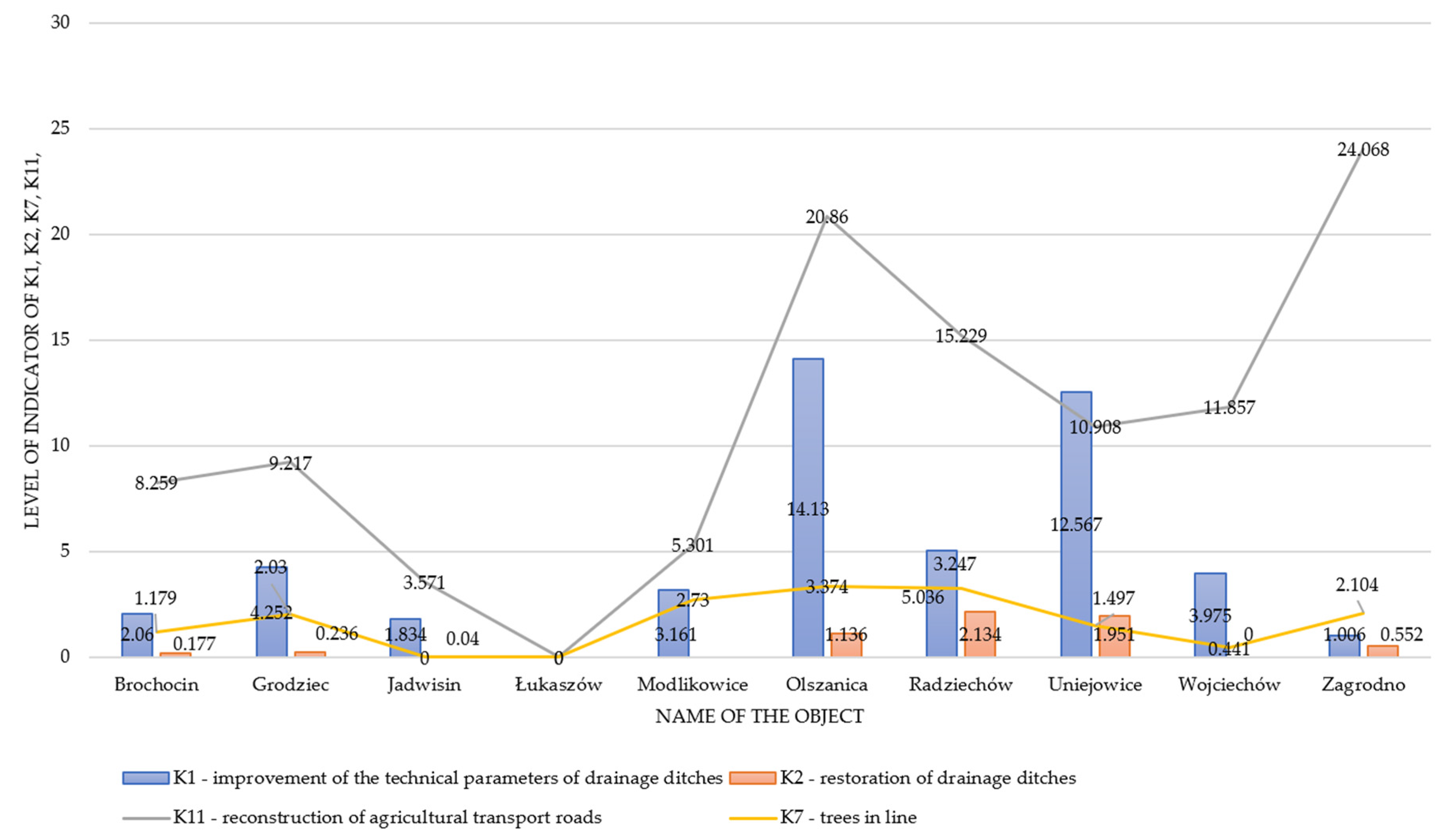
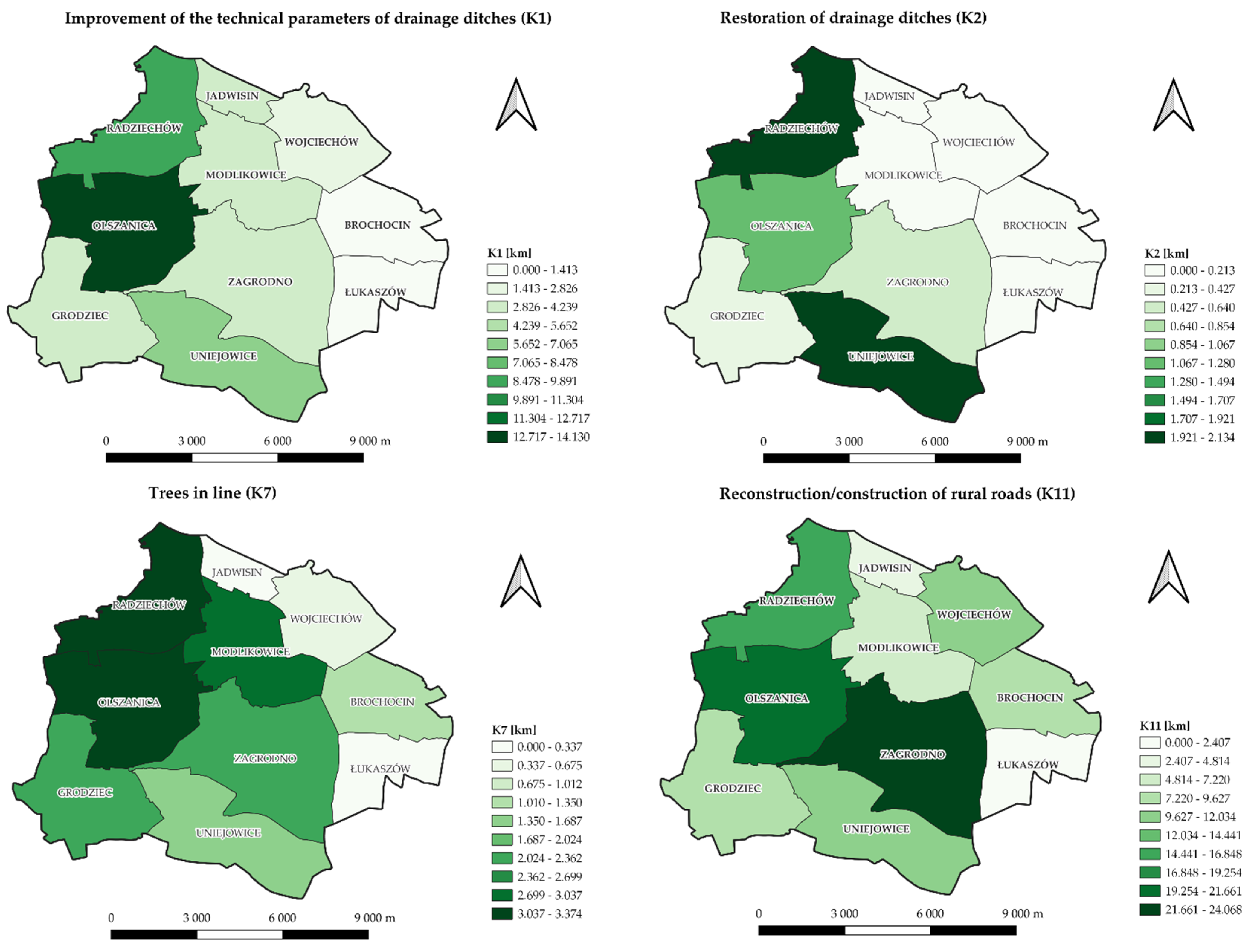
The graph shown in Figure 3 and Figure 4 reveals that most works related to the improvement of the technical parameters of drainage ditches (K1) can be planned in the Olszanica (F)—14.13 km, and in Uniejowice (H)—12.56 km. Restoration of drainage ditches (K2) should be carried out in Radziechów (G)—2.13 km, and in Uniejowice (H)—0.44 km. Reconstruction of agricultural transport roads (K11) was planned in each of the villages under analysis except Łukaszów (D), of which the most was in Olszanica (F)—20.86 km, and in Zagrodno (J)—24.07 km. Trees in line (K7) were planned in eight out of ten villages under analysis, most of them in the villages of Olszanica (F) and Radziechów (G).
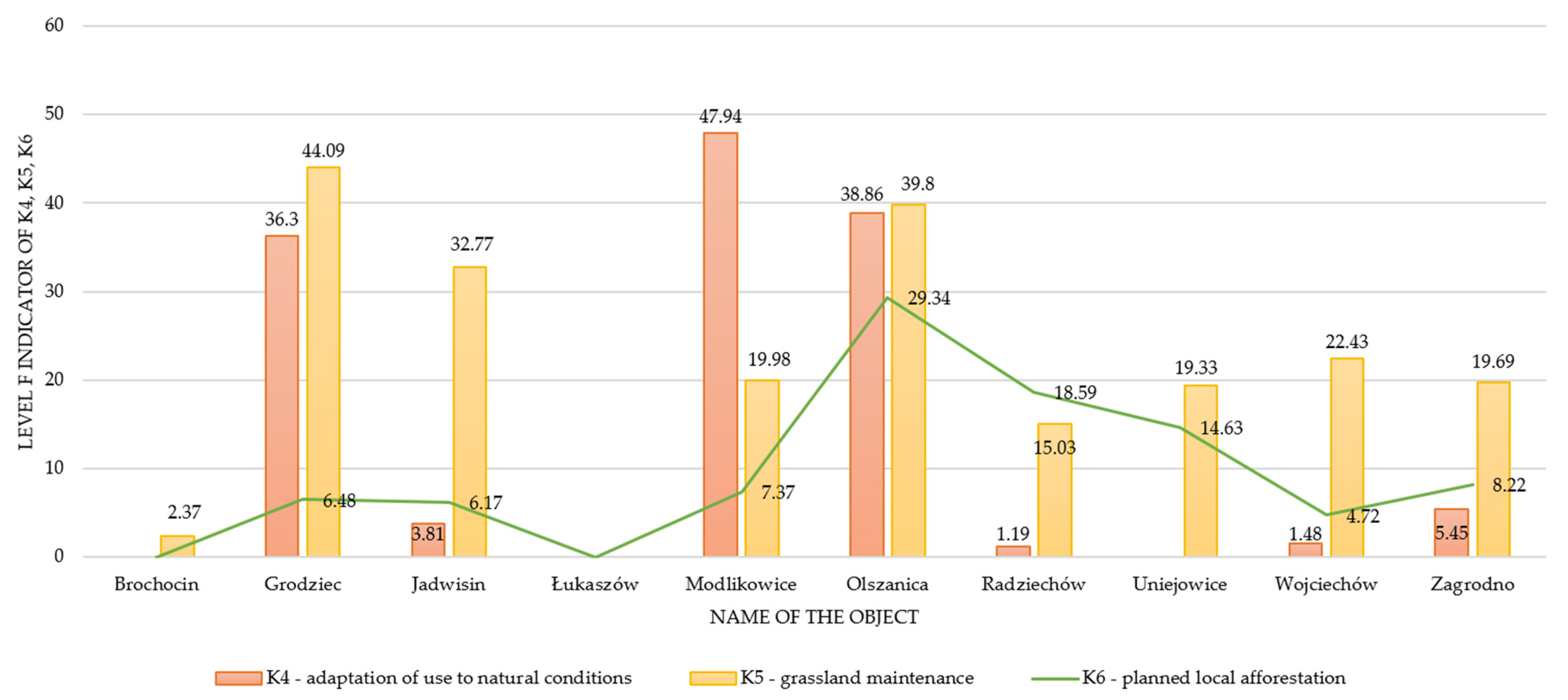
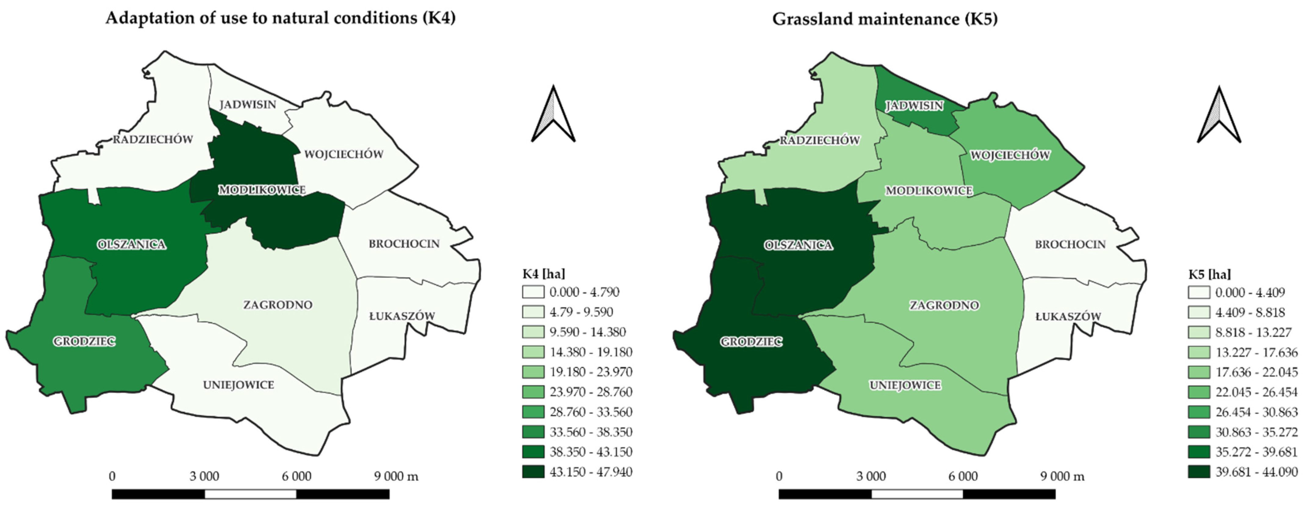
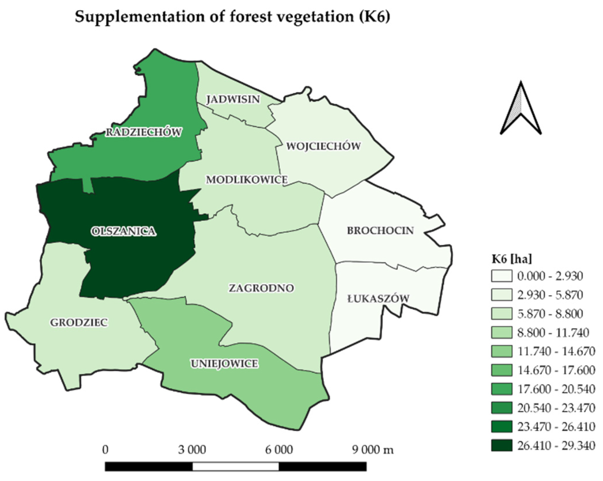
Figure 5 and Figure 6 shows the indicators associated with the adaptation of land use to natural conditions (K4). Most of these works can be planned in the village of Modlikowice (E)—47.94 ha, and in the village of Olszanica (F)—38.86 ha. Grassland maintenance (K5) can be planned in the village of Modlikowice (E)—49.98 ha, and the village of Grodziec (B)—44.09 ha. Local afforestation (K6) is also planned, as the natural forest vegetation succession process has already started. Most such possibilities are found in the village of Olszanica (F)—29.34 ha and in Radziechów (G)—18.59 ha.
The development of set-aside land (see Figure 7 and Figure 8) for agricultural purposes (K8) or for forestry purposes (K9) is planned in eight villages. Most of this land is found in the village of Grodziec, where the development of an area of 3.52 ha for agricultural purposes and of an area of 9.18 ha for forestry purposes is planned, while in the village of Radziechów (G), an area of 1.63 ha is planned to be developed for agricultural purposes, and an area of 2.47 ha is planned to be developed for forestry purposes. The largest area to be developed for forestry purposes is found in the village of Olszanica (F)—9.88 ha, and in the village of Grodziec (B)—9.18 ha. Wasteland reclamation (K10) has been planned in almost all villages except Jadwisin (C). The largest area possibly reclaimed will be in the villages of Modlikowice (4.35 ha) and Zagrodno (J)—3.69 ha. The reconstruction of ponds (K3) is planned in the villages Modlikowice (E), Radziechów (G), Wojciechów (I), and Zagrodno (J). Their surface area ranges from 0.35 to 0.72 ha.

4.2. Standardisation of Indicators

The indicators were standardised according to Formulas (3) and (4) using the so-called unitisation with zero minimum. Standardisation is aimed at converting the values of the variables expressed in different units (ha/km) to make them mutually comparable [126,127]. The application of Formulas (1)–(4) results in all the variables taking values from the interval [0, 1]. After this conversion, the object with the lowest feature value will have a value of 0, while the object with the highest value will have a value of 1. As a result of the application of methods based on quotient transformation, the standardised variable retains the variation in the output variable [127]. Table 2 summarises the indicators standardised according to Formulas (2) and (3).

4.3. The Hierarchy of Objects in Terms of the Potential for Pro-climate Solutions

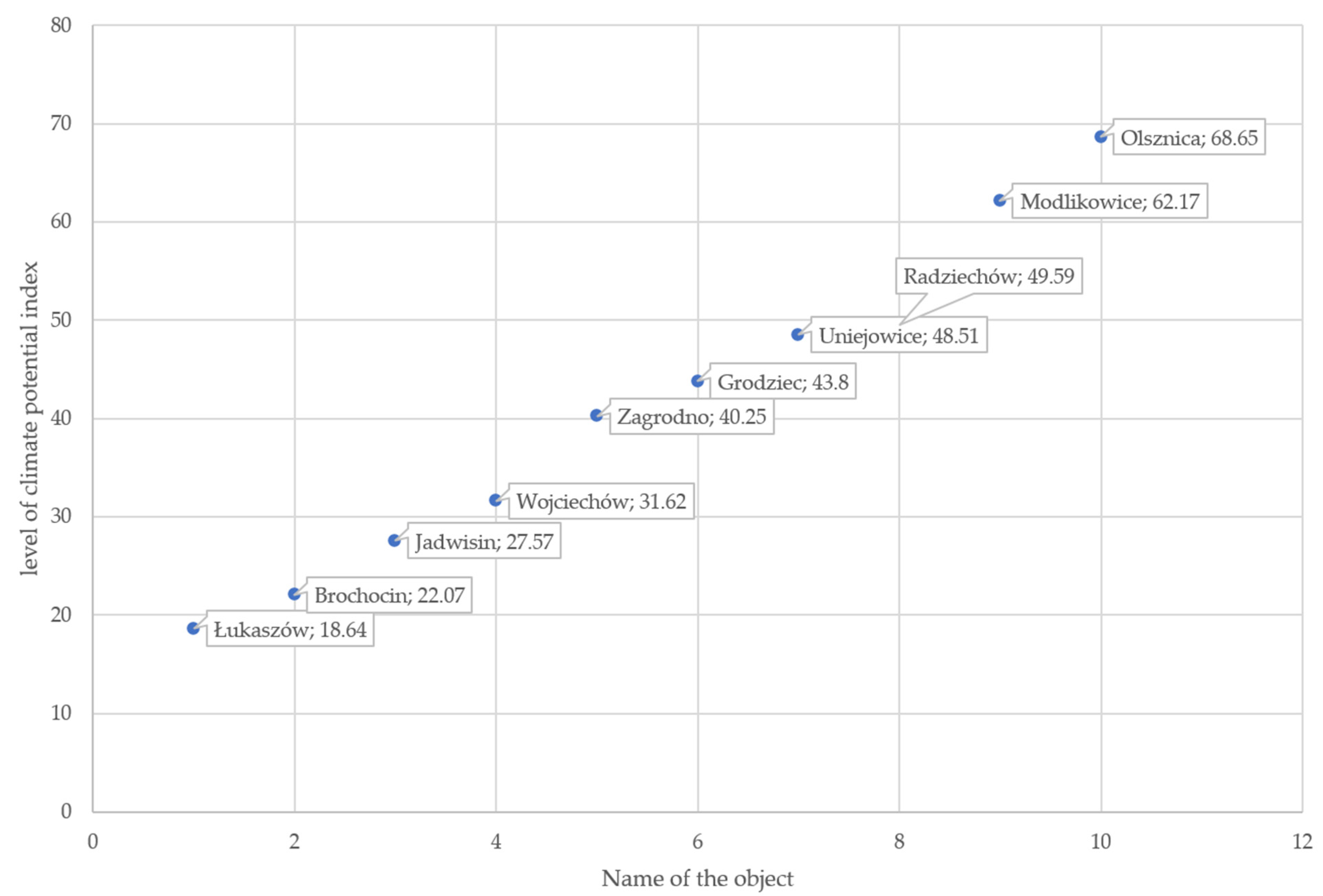
The final form of the variation in the Eij index of the potential for pro-climate solutions is presented in Figure 9.
The conditions prevailing in the villages under analysis are diverse. The potential for applying pro-climate solutions in object D (Łukaszów) and object A (Brochocin) is the lowest. The Eij index in object D is at a level of 18.64, while in object A it is at a level of 22.07. The field inspection revealed that in the area of village D, land reclamation for agricultural/forestry purposes is required. In village A, the following are inter alia required: the improvement and restoration of drainage ditches, grassland maintenance, the introduction of trees in a line, wasteland reclamation, the development of set-aside land for forestry purposes, and the reconstruction of agricultural transport roads. All of these measures are taken on a small scale relative to other objects. Two objects with the greatest potential for the application of pro-climate solutions, namely object F (Olszanica) and object E (Modlikowice), have several times greater possibility and need the application of different solutions. In object F (Olszanica), pro-climate solutions must be applied in all the categories under analysis, except the reconstruction of ponds. This is also the case for object E (Modlikowice), except for the restoration of drainage ditches. Some of the proposed tasks should be implemented over large areas, e.g., in the Modlikowice and Olszanica objects, the adaptation of use to the natural conditions should be implemented over a surface of almost 40 ha (in the object Olszanica), and almost 50 ha (in the object Modlikowice). Both villages are characterised by a wealth of nature in environmental and landscape terms.

4.4. Spatial Analysis

Global Moran’s index I was calculated using the free and open-source software tool PQSTAT (1.8.6 Trial). The spatial distribution of the K1 indicator and peri-aquatic (K1, K2, K3) and peri-trees indicators (K6, K7, K9) characterizing each village was verified based on contiguity edges corners. The results are shown in Table 3.
The results of computing the K1 and peri-aquatic (K1 + K2 + K3) indicators show a negative value of Moran’s index I and a value close to 0. This indicates that the spatial effect of agglomeration does not occur. The studied spatial units (villages) do not merge into clusters but occur as so-called hot spots (see Figure 10). The test statistic for the significance of Moran’s autocorrelation coefficient (z-score) and the p-value pt level confirm that the null hypothesis of a random distribution of index K1 should be accepted.
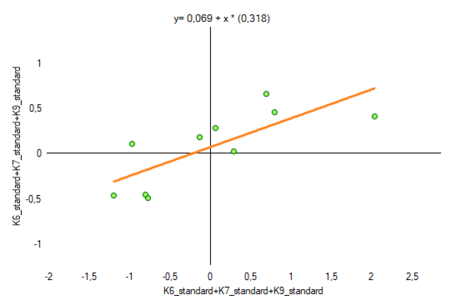
The results of computing the trees-related (K6 + K7 + K9) indicators show a positive value of Moran’s index I. This indicates that the spatial effect of agglomeration occurs. The studied spatial units (villages) merge into clusters (see Figure 11). The test statistic for the significance of Moran’s autocorrelation coefficient (z-score) and the p-value pt level confirm that the null hypothesis of a random distribution of index K1 should be accepted.

5. Discussion

5.1. Pro-Climatic Solution

The impact of climate change on society’s everyday life is becoming increasingly evident, and there is, therefore, a growing need to take measures to counteract the adverse effects. Global greenhouse gas emissions come from five key activity sectors: energy generation and use (73%), industrial processes (6%), agriculture (12%), land use, land use change, and forestry 6%), and waste management (3.2%). Therefore, climate action in rural areas is essential for achieving climate and energy policy objectives. All stakeholders involved in the development of rural areas have a very important role to play in mitigating climate change. Enterprises, institutional contractors, and rural communities serve a crucial role in contributing to the implementation of climate action. This is being achieved through three main pathways: by replacing fossil and carbon-intensive resources, reducing greenhouse gas emissions, and sequestering carbon dioxide in the soil and biomass [133]. Options and opportunities for land (forests and agricultural land) management practices to sequester carbon dioxide and reduce greenhouse gas emissions vary depending on the agricultural or livestock production type, and the tasks carried out by forestry sector enterprises. This is also determined by local conditions, for example, soil type and climatic conditions. Forests and agricultural land serve a significant land function in climate protection, as they cover 80% of the EU’s territory and 88.6% of Poland. In the EU, the European CO2 emission level is negative because sequestration exceeds emissions [133]. Despite Europe’s fairly stable position in terms of CO2 sequestration, EU policy is targeted towards increasing the areas that enable carbon dioxide sequestration in the soil and biomass. Land management practices that contribute to increasing carbon (organic matter) resources involve proper meadow and pasture management, avoiding excessive moisture content in soils, as rotting processes and CH4 emissions occur under anaerobic conditions, the cultivation of cover crops, i.e., catch crops that prevent soil erosion, and the introduction/supplementation of arborescent and shrub vegetation in the landscape. In addition to the current condition analysis, planning, design, and construction of road structures (e.g., road culverts, agricultural transport roads, etc.), environmental and climate protection measures are implemented under land consolidation projects. These include, e.g., the adaptation of land use to natural conditions (e.g., topography) so that erosion can be reduced; the maintenance and restoration of grassland (meadows and pastures); carrying out afforestation works where natural succession has occurred, and restoration of trees planted in line along roads and in places where wind erosion occurs; the development of set-aside land for agricultural/forestry purposes; wasteland reclamation; and the reconstruction/construction of agricultural transport roads, which meet the pro-climate policy objectives set.
This study shows that opportunities to implement pro-climate solutions in spatial units/villages are mixed. The highest indicator (Eij) was achieved in the village/object Olszanica characterized by the need for improving the technical parameters of drainage ditches (K1), planned reforestation due to the already advanced process of natural succession (K6), the need for linear afforestation (K7), and the development of set-aside land into forestry (K9). A similarly high indicator was achieved in the village/site of Modlikowice, where there is a need for the reconstruction of ponds (K3), an adaptation of land use of natural conditions (K4), the development of set-aside land for agricultural purposes (K8), and the reclamation of wasteland (K10). According to the results, peri-aquatic (K1, K2, K3) and peri-trees (K6, K7, K9) zones have the greatest expansiveness in the creation of natural surfaces in the research area. The peri-aquatic areas in the various villages surveyed did not form clusters. Their location is spatially random (see Figure 10). Peri-trees were conditioned differently as they tend to cluster (see Figure 11).
Moreover, the process of developing natural surfaces is facilitated by poorer soil quality, types of land use, the direction of agricultural production, the soil condition/culture, the technical dimensions and shape of parcels in agricultural use (the length, width, and the relation between these two measurements), the advancement of natural succession processes, the need for land drainage and the introduction of shelter belts, and the technical condition of access roads to agricultural land as well as their spatial distribution. Considering ecological management, land consolidation performers should pay particular attention to soil quality. In the area with poor quality soils in respect of agricultural use, the naturally developing natural forms of peri-water and peri-forest should be maintained, while on the site with very good quality soils, efforts should be directed to plan only as many facilities/plots of pro-climate importance as necessary to improve crop quality and climate. Ecological management of the land in consolidation projects in that manner will enable optimum utilization of the potential of the owned space.
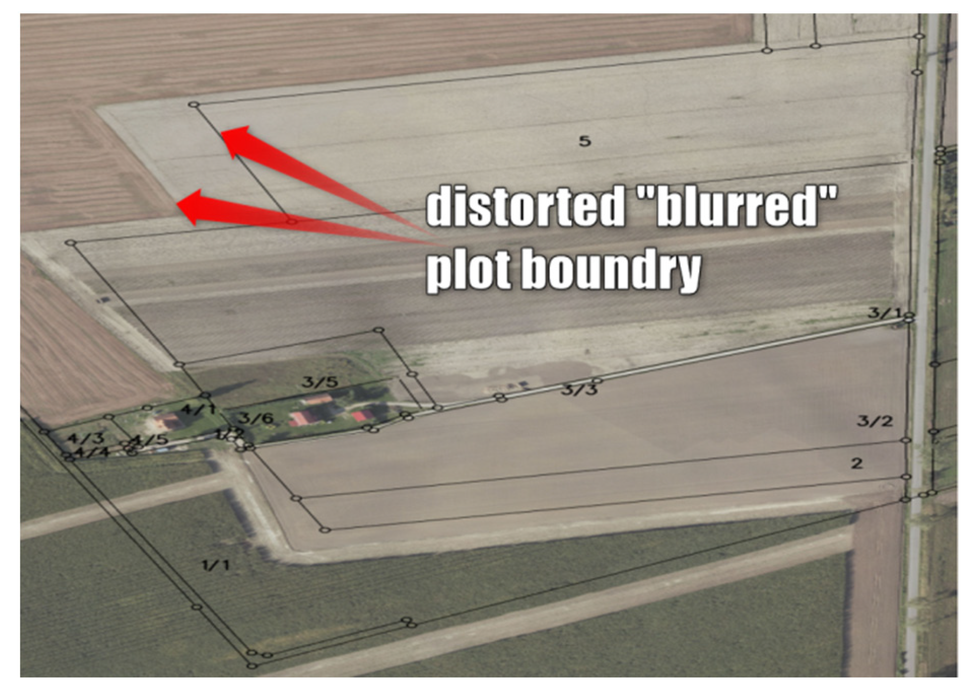
What is also of significant importance is the status of agricultural land holding and the land users’ knowledge of the actual spatial extent of agricultural parcels and, thus, the location of boundaries of the parcels in agricultural use. This is inextricably linked to the validity of the survey and cartographic documentation of the area under analysis. An owner/farmer/land user, being aware of the course of the boundaries of the property on which they carry out agricultural production, uses land within the boundaries known to them and indicated by the owner/legal predecessor. The lack of surveying and cartographic documentation update processes results in the “blurring” of these boundaries if they are not based on natural and artificial objects that are permanent and distinct in the field. In many cases, the land is used within boundaries that are incorrect or inconsistent with the actual situation (see Figure 12, the boundary of the actual agricultural land use and the legal extent of the ownership/holding before the Land and Property Register modernisation process), which may have a stimulating or destimulating effect on the development of natural landforms such as the field margin, the field–forest boundary, vegetation near water bodies and drainage ditches, etc.
The analysed potential (the higher the index, the greater the potential) of the area for the implementation of pro-climate solutions in individual micro-locations shows that it is not identical. When implementing a land consolidation project and focusing only on the technical and spatial factors, only the problems existing in this regard are solved. Meanwhile, we should strive not to deteriorate the environment to meet basic human needs but to direct the process in a manner that improves the current and future state of the environment.
Nowadays, considering the significance of the new climate change challenges, we need to keep a close eye on the possibilities existing in rural areas while striking a balance between the needs of the food sector, the natural potential of a location, and the needs of the planet. According to research results, society, i.e., the population, has contributed considerably to climate change, and being aware of the opportunities to mitigate this contribution should become a priority. The proposed potential assessment index may also have the function of supporting decision-making processes when selecting an object for the obligatory implementation of a land consolidation project.

5.2. Limitations of the Research

The construction of the index used in this report was based on data obtained from third parties and their measurements. Their quality cannot be guaranteed, although the data were acquired from renowned sources. The resulting data sets were reviewed and evaluated in detail for any inconsistencies. The estimated and analysed pro-climatic index does not differentiate increases and decreases relative to the base parameters, but rather it measures the degree of the potential of the natural environment at the moment.
The pro-climatic solution can be examined on the local level, and the indices reflecting the local features focus on the environment and landscape. It aims to show the individual condition and capabilities of the specific location.

6. Conclusions and Implications for Land Policy

Since Poland’s accession to the European Union structures, land consolidation has acquired new objectives: to protect natural environmental determinants and to consolidate and involve the local community in the accomplishment of objectives concerning their place of residence, workplace, and surroundings (the environment). Making the most of the local natural potential boosts agricultural development, promotes ecology, and benefits the rural population. The proper solution to local land cultivation problems not only correlates with the patchwork of parcels, the elimination of which is the headline target of land consolidation, but also with the richness of the natural environment found in the micro-location under study. Therefore, the state government should reinforce tools for supporting such land use that takes into account ecology, environmental protection, and the safety of rural populations while emphasising the crucial importance of these measures in climate protection.
According to research, peri-tree land can cluster, meaning that its character represents a spatial continuity. During the land consolidation process, this continuity should be preserved, especially in areas with inferior soil quality. A combination of public awareness, ecological management, and the ability to effectively use the maximum land area for agricultural purposes, during the land consolidation process, can effectively solve the problems of regional agriculture and support climate change adaptation and mitigation activities.

Author Contributions

Conceptualization, K.K.-B., J.R., M.S. and P.L.; methodology, K.K.-B. and J.R.; software, K.K.-B. and J.R.; validation, K.K.-B., J.R., P.L. and M.S.; formal analysis, K.K.-B. and A.M.; investigation, K.K.-B. and P.L.; resources, K.K.-B. and J.R.; data curation, K.K.-B. and J.R.; writing—original draft preparation, K.K.-B.; writing—review and editing, K.K.-B. visualization, K.K.-B., J.R. and A.M.; supervision, M.S. and P.L.; project administration, K.K.-B.; funding acquisition, K.K.-B. All authors have read and agreed to the published version of the manuscript.

Funding

This research received no external funding.

Institutional Review Board Statement

Not applicable.

Informed Consent Statement

Not applicable.

Data Availability Statement

All data used for research are included in the content of the article and in Table 1, Table 2 and Table 3.

Conflicts of Interest

The authors declare no conflict of interest.

Nomenclature

SymbolFeature
j value of weight of jth variable
i n d e x x i j value of the jth variable for ith spatial unit
m a x   x i j the maximum value of the jth variable for ith spatial unit
m i n   x i j the minimum value of the jth variable for ith spatial unit
Ikthe global Moran’s index for the kth index
nthe total number of spatial units
x i j ,   x i j the values of jth variable for ith and i’th compared spatial units
x ¯ j the mean value of the variable for all jth spatial units
w i i elements of the spatial matrix of weights for ith and i’th spatial units
S 0 k the value of aggregate weights in k index
Z(I)kthe number of standard deviations of Moran’s I about the mean in the kth index
E(I)kthe expected value of Moran’s I in the kth index
Var(I)kthe variance value of Moran’s I in the kth index
w i i elements of the spatial matrix of weights for i’th and ith spatial units
w j quantity of sum of weights in the column of jth variable
w j quantity of sum of the weights in the row of jth variable

References

  1. O’Neill, B.C.; Oppenheimer, M.; Warren, R.; Hallegatte, S.; Kopp, R.E.; Pörtner, H.O.; Scholes, R.; Birkmann, J.; Foden, W.; Licker, R.; et al. IPCC reasons for concern regarding climate change risks. Nat. Clim. Chang. 2017, 7, 28–37. [Google Scholar] [CrossRef] [Green Version]
  2. Ružbarský, J. Soil carbon stocks and land use change: A meta-analysis. Glob. Change Biol. 2002, 8, 345–360. [Google Scholar] [CrossRef]
  3. Li, X.; Hui, N.; Yang, Y.; Ma, J.; Luo, Z.; Chen, F. Short-term effects of land consolidation of dryland-to-paddy conversion on soil CO2 flux. J. Environ. Manag. 2021, 292, 112691. [Google Scholar] [CrossRef] [PubMed]
  4. Guo, B.; Fang, Y.; Jin, X.; Zhou, Y. Monitoring the effects of land consolidation on the ecological environmental quality based on remote sensing: A case study of Chaohu Lake Basin, China. Land Use Policy 2020, 95, 104569. [Google Scholar] [CrossRef]
  5. Boateng, I.; Dalyot, S.; Enemark, S.; Friesecke, F.; Mitchell, D.; van der Molen, P.; Pearse, M.; Sutherland, M.; Vranken, M. The Surveyors’ Role in Monitoring, Mitigating, and Adapting to Climate Change; International Federation of Surveyors: Copenhagen, Denmark, 2014. [Google Scholar]
  6. Budziszewska, M.; Kardaś, A.; Bohdanowicz, Z.; Klimatyczne, A.B.C. Interdyscyplinarne Podstawy Współczesnej Wiedzy o Zmianie Klimatu; Wydawnictwa Uniwersytetu: Warszawskiego, Poland, 2021. [Google Scholar]
  7. Wilson, E.O. Half-Earth: Our Planet’s Fight for Life; WW Norton & Company: New York, NY, USA, 2016. [Google Scholar]
  8. Ritchie, H.; Roser, M. Land Use. 2013. Available online: https://ourworldindata.org/land-use (accessed on 26 October 2022).
  9. Vitikainen, A. An Overview of Land Consolidation in Europe. Nord. J. Surv. Real Estate Res. 2004, 1, 25–43. [Google Scholar]
  10. Pašakarnis, G.; Maliene, V. Towards sustainable rural development in Central and Eastern Europe: Applying land consolida-tion. Land Use Policy 2010, 27, 545–549. [Google Scholar] [CrossRef]
  11. Demetriou, D.; Stillwell, J.; See, L. Land consolidation in Cyprus: Why is an integrated planning and decision support system required? Land Use Policy 2012, 29, 131–142. [Google Scholar] [CrossRef]
  12. Zhou, Y.; Li, Y.; Xu, C. Land consolidation and rural revitalization in China: Mechanisms and paths. Land Use Policy 2020, 91, 104379. [Google Scholar] [CrossRef]
  13. Wei, X.; Liu, Y.; Wang, N. Spatial disparity pattern of land consolidation projects in Hubei province. Trans. Chin. Soc. Agric. Eng. 2014, 30, 195–203. [Google Scholar]
  14. Uyan, M.; Cay, T.; Inceyol, Y.; Hakli, H. Comparison of designed different land reallocation models in land consolidation: A case study in Konya/Turkey. Comput. Electron. Agric. 2015, 110, 249–258. [Google Scholar] [CrossRef]
  15. Shi, Y.; Cao, X.; Fu, D.; Wang, Y. Comprehensive Value Discovery of Land Consolidation Projects: An Empirical Analysis of Shanghai, China. Sustainability 2018, 10, 2039. [Google Scholar] [CrossRef] [Green Version]
  16. Du, H. Application of vetiver grass in slope retaining and consolidation project in suide test area. J. Discret. Math. Sci. Cryptogr. 2017, 20, 1321–1326. [Google Scholar] [CrossRef]
  17. Van Dijk, T. Dealing with Land Fragmentation in Central Europe: A Critical Assessment on the Use of Western Instruments; Eburon: Delft, The Netherlands, 2003; p. 228. [Google Scholar]
  18. Van Dijk, T. Complications for traditional land consolidation in Central Europe. Geoforum 2007, 38, 505–511. [Google Scholar] [CrossRef]
  19. Hartvigsen, M. Land Consolidation in Central and Eastern European Countries. In Proceedings of the Shaping the Change, XXIII FIG Congress, Munich, Germany, 8–13 October 2006. [Google Scholar]
  20. Bonadonna, A.; Rostagno, A.; Beltramo, R. Improving the Landscape and Tourism in Marginal Areas: The Case of Land Consolidation Associations in the North-West of Italy. Land 2020, 9, 175. [Google Scholar] [CrossRef]
  21. Jin, X.; Zhang, Z.; Wu, X.; Xiang, X.; Sun, W.; Bai, Q.; Zhou, Y. Co-ordination of land exploitation, exploitable farmland reserves and national planning in China. Land Use Policy 2016, 57, 682–693. [Google Scholar] [CrossRef]
  22. Ntihinyurwa, P.D.; de Vries, W.T.; Chigbu, U.E.; Dukwiyimpuhwe, P.A. The positive impacts of farm land fragmentation in Rwanda. Land Use Policy 2018, 81, 565–581. [Google Scholar] [CrossRef]
  23. Tang, X.; Pan, Y.; Liu, Y. Analysis and demonstration of investment implementation model and paths for China’s cultivated land consolidation. Appl. Geogr. 2017, 82, 24–34. [Google Scholar] [CrossRef]
  24. Wójcik-Leń, J.; Sobolewska-Mikulska, K.; Sajnóg, N.; Leń, P. The idea of rational management of problematic agricultural areas in the course of land consolidation. Land Use Policy 2018, 78, 36–45. [Google Scholar] [CrossRef]
  25. Qu, Y.; Jiang, G.-h.; Li, Z.; Tian, Y.; Wei, S. Understanding rural land use transition and regional consolidation implications in China. Land Use Policy 2019, 82, 742–753. [Google Scholar] [CrossRef]
  26. Li, Y.; Liu, Y.; Long, H.; Cui, W. Community-based rural residential land consolidation and allocation can help to revitalize hollowed villages in traditional agricultural areas of China: Evidence from Dancheng County, Henan Province. Land Use Policy 2014, 39, 188–198. [Google Scholar] [CrossRef]
  27. Jabłońska, E.; Wiśniewska, M.; Marcinkowski, P.; Grygoruk, M.; Walton, C.R.; Zak, D.; Hoffmann, C.C.; Larsen, S.E.; Trepel, M.; Kotowski, W. Catchment-Scale Analysis Reveals High Cost-Effectiveness of Wetland Buffer Zones as a Remedy to Non-Point Nutrient Pollution in North-Eastern Poland. Water 2020, 12, 629. [Google Scholar] [CrossRef] [Green Version]
  28. Lovell, S.T.; Sullivan, W.C. Environmental benefits of conservation buffers in the United States: Evidence, promise, and open questions. Agric. Ecosyst. Environ. 2006, 112, 249–260. [Google Scholar] [CrossRef]
  29. Pijanowski, J.M.; Bogdał, A.; Książek, L.; Wojewodzic, T.; Kowalik, T.; Wałęga, A.; Zarzycki, J.; Zadrożny, P.; Nicia, P.; Strużyński, A.; et al. Środowiskowe i Społeczne Efekty Scaleń Gruntów; Wydawnictwo Uniwersytetu Rolniczego w Krakowie: Wydawnictwo, Poland, 2021. [Google Scholar]
  30. Kundzewicz, Z.; Banasik, K.; Błażejewski, R.; Januchta-Szostak, A.; Jokiel, P.; Kochanek, K.; Kutek, K.; Konieczny, R.; Majewski, W.; Nachlik, E.; et al. Alert wodny 2. Konieczna Jest Redukcja Ryzyka Powodzi i Suszy; Open Eyes Economy: Kraków, Poland, 2020. [Google Scholar]
  31. Alfieri, L.; Feyen, L.; Di Baldassarre, G. Increasing flood risk under climate change: A pan-European assessment of the benefits of four adaptation strategies. Clim. Chang. 2016, 136, 507–521. [Google Scholar] [CrossRef] [Green Version]
  32. Duan, H.; Lu, X.; Talamini, G. The Impacts of Environmentally Mitigated River Channelization on Agriculture in Hong Kong. Urbannie Urbanus J. 2022, 7, 145–156. [Google Scholar]
  33. Verbrugge, L.; Born, R.V.D. The role of place attachment in public perceptions of a re-landscaping intervention in the river Waal (The Netherlands). Landsc. Urban Plan. 2018, 177, 241–250. [Google Scholar] [CrossRef] [Green Version]
  34. Juan, A.; Gori, A.; Sebastian, A. Comparing flood plain evolution in channelized and unchannelized urban watersheds in Houston, Texas. J. Flood Risk Manag. 2020, 13, e12604. [Google Scholar] [CrossRef] [Green Version]
  35. Duh, J.-D.; Shandas, V.; Chang, H.; George, L.A. Rates of urbanisation and the resiliency of air and water quality. Sci. Total Environ. 2008, 400, 238–256. [Google Scholar] [CrossRef]
  36. Palmer, M.A.; Bernhardt, E.S.; Allan, J.D.; Lake, P.S.; Alexander, G.; Brooks, S.; Carr, J.; Clayton, S.; Dahm, C.N.; Follstad Shah, J.; et al. Standards for ecologically successful river restoration. J. Appl. Ecol. 2005, 42, 208–217. [Google Scholar] [CrossRef]
  37. Talamini, G.; Zhang, Q.; Viganò, P. The condition of urban agriculture in a Chinese global city: Evidence from the field. Environ. Urban. 2022, 34, 99–121. [Google Scholar] [CrossRef]
  38. Jacobs, M.H.; Buijs, A.E.; 2011. Understanding stakeholders’ attitudes toward water management interventions: Role of place meanings. Water Resour. Res. 2011, 47, 1–11. [Google Scholar] [CrossRef]
  39. Dixon, A.B.; Hailu, A.; Wood, A.P. The role and importance of wetlands in Ethiopia. In Proceedings of the Wetland Awareness Creation and Activity Identification Workshop in Amhara National Regional State, Bahar Dar, Ethiopia, 23 January 2001; pp. 8–13. [Google Scholar]
  40. Mioduszewski, W.; Okruszko, H.; Łoś, M. Rola Melioracji W Środowisku Przyrodniczym; Wydawnictwo Komitetu Melioracji i Inżynierii Środowiska Rolniczego PAN: Warszawa, Poland, 1990. [Google Scholar]
  41. Józefaciuk, A.; Józefaciuk, C. Ochrona Gruntów Przed Erozją; Wydawnictwo IUNG: Puławy, Poland, 1999. [Google Scholar]
  42. Strazzera, E.; Atzori, R.; Meleddu, D.; Statzu, V. Assessment of renaturation measures for improvements in ecosystem services and flood risk mitigation. J. Environ. Manag. 2021, 292, 112743. [Google Scholar] [CrossRef] [PubMed]
  43. Odjugo, P.A.-A.O. Quantifying the Cost of Climate Change Impact in Nigeria: Emphasis on Wind and Rainstorms. J. Hum. Ecol. 2009, 28, 93–101. [Google Scholar] [CrossRef]
  44. Zajączkowski, J. Zadrzewienia—Narzędzie kształtowania środowiska na terenach rolniczych. In Proceedings of the XIX Konferencja Naukowa Nowe Tendencje W Teorii I Praktyce Urządzania Obszarów Wiejskich, Szczytno, Poland, 4–5 September 2014. [Google Scholar]
  45. Thaler, S.; Eitzinger, J.; Trnka, M.; Dubrovsky, M. Impacts of climate change and alternative adaptation options on winter wheat yield and water productivity in a dry climate in Central Europe. J. Agric. Sci. 2012, 150, 537–555. [Google Scholar] [CrossRef]
  46. Review on Windbreaks Agroforestry as a Climate Smart Agriculture Practices. Am. J. Agric. For. 2021, 9, 342. [CrossRef]
  47. Doelman, J.C.; Stehfest, E.; van Vuuren, D.P.; Tabeau, A.; Hof, A.F.; Braakhekke, M.C.; Gernaat, D.E.H.J.; Berg, M.v.D.; van Zeist, W.; Daioglou, V.; et al. Afforestation for climate change mitigation: Potentials, risks and trade-offs. Glob. Chang. Biol. 2019, 26, 1576–1591. [Google Scholar] [CrossRef] [PubMed]
  48. Liu, H.; Xu, C.; Allen, C.D.; Hartmann, H.; Wei, X.; Yakir, D.; Wu, X.; Yu, P. Nature-based framework for sustainable afforestation in global drylands under changing climate. Glob. Chang. Biol. 2022, 28, 2202–2220. [Google Scholar] [CrossRef]
  49. Forster, E.J.; Healey, J.R.; Dymond, C.; Styles, D. Commercial afforestation can deliver effective climate change mitigation under multiple decarbonisation pathways. Nat. Commun. 2021, 12, 3831. [Google Scholar] [CrossRef]
  50. Strandberg, G.; Kjellström, E. Climate Impacts from Afforestation and Deforestation in Europe. Earth Interact. 2019, 23, 1–27. [Google Scholar] [CrossRef]
  51. Chen, Z.; Yu, G.; Wang, Q. Effects of climate and forest age on the ecosystem carbon exchange of afforestation. J. For. Res. 2020, 31, 365–374. [Google Scholar] [CrossRef] [Green Version]
  52. Tamang, B.; Pala, N.A.; Shukla, G.; Rashid, M.; Rather, M.M.; Bhat, J.A.; Masoodi, T.; Chakravarty, S. Trees outside forest (TOFs) aids in mitigating global climatic change through carbon sequestration: Example from academic institutional landscapes. Acta Ecol. Sin. 2021, 41, 351–357. [Google Scholar] [CrossRef]
  53. Zaki, S.A.; Toh, H.J.; Yakub, F.; Saudi, A.S.M.; Ardila-Rey, J.A.; Muhammad-Sukki, F. Effects of Roadside Trees and Road Orientation on Thermal Environment in a Tropical City. Sustainability 2020, 12, 1053. [Google Scholar] [CrossRef] [Green Version]
  54. Brandle, J.R.; Hodges, L.; Zhou, X.H. Windbreaks in North American Agricultural Systems. Agronomy and Horticulture. Fac. Publ. 2004, 389, 65–78. Available online: https://digitalcommons.unl.edu/agronomyfacpub/389 (accessed on 20 February 2023).
  55. Mcnaughton, K. Effects of Windbreaks on Turbulent Transport and Microclimate. Agric. Ecosyst. Environ. 1988, 22, 17–39. [Google Scholar] [CrossRef]
  56. Cleugh, H.A. Field measurements of windbreak effects on airflow, turbulent exchanges and microclimates. Aust. J. Exp. Agric. 2002, 42, 665–677. [Google Scholar] [CrossRef]
  57. Cleugh, H.A.; Hughes, D.E. Impact of shelter on crop microclimates: A synthesis of results from wind tunnel and field experiments. Aust. J. Exp. Agric. 2002, 42, 679–701. [Google Scholar] [CrossRef]
  58. Chendev, Y.G.; Sauer, T.J.; Ramirez, G.H.; Burras, C.L. History of East European Chernozem Soil Degradation; Protection and Restoration by Tree Windbreaks in the Russian Steppe. Sustainability 2015, 7, 705–724. [Google Scholar] [CrossRef] [Green Version]
  59. Mander, Ü.; Tournebize, J.; Tonderski, K.; Verhoeven, J.T.; Mitsch, W.J. Planning and establishment principles for constructed wetlands and riparian buffer zones in agricultural catchments. Ecol. Eng. 2017, 103, 296–300. [Google Scholar] [CrossRef]
  60. Mander, Ü.; Tournebize, J.; Sauvage, S.; Sánchez-Perez, J.M. Wetlands and buffer zones in watershed management. Ecol. Eng. 2017, 103, 289–295. [Google Scholar] [CrossRef]
  61. Chabrerie, O.; Jamoneau, A.; Gallet-Moron, E.; Decocq, G. Maturation of forest edges are constrained by neighbouring agricultural land management. J. Veg. Sci. 2013, 24, 58–69. [Google Scholar] [CrossRef]
  62. Moreno, G.; Gonzalez-Bornay, G.; Pulido, F.; Lopez-Diaz, M.L.; Bertomeu, M.; Juarez, E.; Diaz, M. Exploring the causes of high biodiversity of Iberian dehesas: The importance of wood pastures and marginal habitats. Agrofor. Syst. 2016, 90, 87–105. [Google Scholar] [CrossRef]
  63. Paul, C.; Weber, M.; Knoke, T. Agroforestry versus farm mosaic systems—Comparing land-use efficiency, economic returns and risks under climate change effects. Sci. Total. Environ. 2017, 587–588, 22–35. [Google Scholar] [CrossRef] [PubMed]
  64. Fried, G.; Villers, A.; Porcher, E. Assessing non-intended effects of farming practices on field margin vegetation with a functional approach. Agric. Ecosyst. Environ. 2018, 261, 33–44. [Google Scholar] [CrossRef] [Green Version]
  65. Stein-Bachinger, K.; Gottwald, F.; Haub, A.; Schmidt, E. To what extent does organic farming promote species richness and abundance in temperate climates? A review. Org. Agric. 2020, 11, 1–12. [Google Scholar] [CrossRef] [Green Version]
  66. Visscher, A.M.; Vanek, S.; Meza, K.; de Goede, R.G.; Valverde, A.A.; Ccanto, R.; Olivera, E.; Scurrah, M.; Fonte, S.J. Eucalyptus and alder field margins differ in their impact on ecosystem services and biodiversity within cropping fields of the Peruvian Andes. Agric. Ecosyst. Environ. 2020, 303, 107107. [Google Scholar] [CrossRef]
  67. Wiström, B.; Nielsen, A.B. Decisive environmental characteristics for woody regrowth in forest edges—Patterns along complex environmental gradients in Southern Sweden. For. Ecol. Manag. 2016, 363, 47–62. [Google Scholar] [CrossRef]
  68. Sabatini, F.M.; Burrascano, S.; Tuomisto, H.; Blasi, C. Ground layer plant species turnover and beta diversity in Southern-European old-growth forests. PLoS ONE 2014, 9, e95244. [Google Scholar] [CrossRef]
  69. Beier, P. Conceptualizing and Designing Corridors for Climate Chang. Ecol. Restor. 2012, 4, 30. Available online: https://www.jstor.org/stable/43441504 (accessed on 20 October 2022).
  70. Błońska, E.; Lasota, J.; Vasconcelos da Silva, G.R.; Vanguelova, E.; Ashwood, F.; Tibbett, M.; Watts, K.; Lukac, M. Soil organic matter stabilization and carbon-cycling enzyme activity are affected by land management. Ann. For. Res. 2020, 63, 71–86. [Google Scholar] [CrossRef]
  71. Lindgren, J.; Kimberley, A.; Cousins, S.A.O. The complexity of forest borders determines the understorey vegetation. Appl. Veg. Sci. 2018, 21, 85–93. [Google Scholar] [CrossRef]
  72. Woch, F.; Borek, R. The Role Of Management Of The Field-Forest Boundary In Poland’s Process Of Agricultural Restructuring. Pap. Glob. Chang. IGBP 2015, 22, 83–100. [Google Scholar] [CrossRef] [Green Version]
  73. Beita, C.M.; Murillo, L.F.S.; Alvarado, L.D.A. Ecological corridors in Costa Rica: An evaluation applying landscape structure, fragmentation-connectivity process, and climate adaptation. Conserv. Sci. Pract. 2021, 3, e475. [Google Scholar] [CrossRef]
  74. Heller, N.E.; Zavaleta, E.S. Biodiversity management in the face of climate change: A review of 22 years of recommendations. Biol. Conserv. 2009, 142, 14–32. [Google Scholar] [CrossRef]
  75. Krosby, M.; Tewksbury, J.; Haddad, N.M.; Hoekstra, J. Ecological Connectivity for a Changing Climate. Conserv. Biol. 2010, 24, 1686–1689. [Google Scholar] [CrossRef] [PubMed]
  76. Watson, R.T.; Noble, I.R.; Bolin, B.; Ravindranath, N.H.; Verardo, D.J.; Dokken, D.J. (Eds.) Land Use, Land-Use Change, and Forestry; Cambridge University Press: Cambridge, UK, 2000. [Google Scholar]
  77. Munasinghe, M.; Swart, R. Primer on Climate Change and Sustainable Development; Cambridge University Press: Cambridge, UK, 2005. [Google Scholar]
  78. Harris, J.A.; Hobbs, R.J.; Higgs, E.; Aronson, J. Ecological Restoration and Global Climate Change. Restor. Ecol. 2006, 14, 170–176. [Google Scholar] [CrossRef]
  79. Jończyk, K. Ochrona Gruntów Przed Erozją; Ministerstwo Rolnictwa i Rozwoju Wsi: Warszawa, Poland, 2003. [Google Scholar]
  80. Reubens, B.; Poesen, J.; Danjon, F.; Geudens, G.; Muys, B. The role of fine and coarse roots in shallow slope stability and soil erosion control with a focus on root system architecture: A review. Trees 2007, 21, 385–402. [Google Scholar] [CrossRef]
  81. Gyssels, G.; Poesen, J.; Bochet, E.; Li, Y. Impact of plant roots on the resistance of soils to erosion by water: A review. Prog. Phys. Geogr. 2005, 29, 189–217. [Google Scholar] [CrossRef] [Green Version]
  82. Smith, S.; De Smet, I. Root system architecture: Insights from Arabidopsis and cereal crops. Philos. Trans. R. Soc. B Biol. Sci. 2012, 367, 1441–1452. [Google Scholar] [CrossRef] [Green Version]
  83. Skuodienė, R.; Kinderienė, I.; Tomchuk, D.; Šlepetys, J.; Karčauskienė, D. Root development of temporary and permanent grasslands and their anti-erosion significance on a hilly terrain. Zemdirb. Agric. 2020, 107, 209–216. [Google Scholar] [CrossRef]
  84. Wang, J.; Wang, K.; Zhang, M.; Zhang, C. Impacts of climate change and human activities on vegetation cover in hilly southern China. Ecol. Eng. 2015, 81, 451–461. [Google Scholar] [CrossRef]
  85. Xu, Y.; Yan, R.; Linqiang, T.; Kang, C.; Li, L. Experimental Study of Erosion on Expansive Soil Slope Strengthened by HPTRM System. In New Developments in Soil Characterization and Soil Stability. GeoChina, 2019. Sustainable Civil Infrastructures; Frikha, W., Kawamura, S., Liao, W.C., Eds.; Springer: Cham, Switzerland, 2019. [Google Scholar] [CrossRef]
  86. Stańczuk-Gałwiaczek, M.; Sobolewska-Mikulska, K.; Ritzema, H.; van Loon-Steensma, J.M. Integration of water management and land consolidation in rural areas to adapt to climate change: Experiences from Poland and the Netherlands. Land Use Policy 2018, 77, 498–511. [Google Scholar] [CrossRef]
  87. Wang, H.; Yang, Z.; Saito, Y.; Liu, J.P.; Sun, X.; Wang, Y. Stepwise decreases of the Huanghe (Yellow River) sediment load (1950–2005): Impacts of climate change and human activities. Glob. Planet. Chang. 2007, 57, 331–354. [Google Scholar] [CrossRef]
  88. Lu, X.; Ran, L.; Liu, S.; Jiang, T.; Zhang, S.; Wang, J. Sediment loads response to climate change: A preliminary study of eight large Chinese rivers. Int. J. Sediment Res. 2013, 28, 1–14. [Google Scholar] [CrossRef]
  89. Semadeni-Davies, A.; Hernebring, C.; Svensson, G.; Gustafsson, L.-G. The impacts of climate change and urbanisation on drainage in Helsingborg, Sweden: Suburban stormwater. J. Hydrol. 2008, 350, 114–125. [Google Scholar] [CrossRef]
  90. Stričević, R.; Srdjević, Z.; Lipovac, A.; Prodanović, S.; Petrović-Obradović, O.; Ćosić, M.; Djurović, N. Synergy of experts’ and farmers’ responses in climate-change adaptation planning in Serbia. Ecol. Indic. 2020, 116, 106481. [Google Scholar] [CrossRef]
  91. Radojevic, B.D.; Breil, P.; Chocat, B. Assessing impact of global change on flood regimes. Int. J. Clim. Chang. Strat. Manag. 2010, 2, 167–179. [Google Scholar] [CrossRef]
  92. Kaiser, N.; Barstow, C.K. Rural Transportation Infrastructure in Low-and Middle-Income Countries: A Review of Impacts, Implications, and Interventions. Sustainability 2022, 14, 2149. [Google Scholar] [CrossRef]
  93. Shamdasani, Y. Rural road infrastructure & agricultural production: Evidence from India. J. Dev. Econ. 2021, 152, 102686. [Google Scholar] [CrossRef]
  94. Rosman, P. Social Networks and Rural Feeder Roads: Livelihood Effects of Social Networks in Rural Remote Communities in the Context of Increasing Mobility-Evidence from Tigray Region, Ethiopia. 2015. Available online: http://roadsforwater.org/wp-content/uploads/2015/10/MSc-IDS-Pieter-Rosman-Feeder-road-development.pdf (accessed on 20 October 2022).
  95. Bhandari, S. Ranking rural road projects: Weighting different evaluation criteria with a focus on the case of Nepal. Int. J. Eng. Res. Sci. Technol. 2016, 5, 49–69. [Google Scholar]
  96. Ampadu, S.I.K.; Addison, F.K. A comparison between the life cycle cost of gravel and of bituminous surfacing options for feeder roads in Ghana. Int. J. Pavement Eng. 2015, 18, 1–8. [Google Scholar] [CrossRef]
  97. Rattanachot, W.; Wang, Y.; Chong, D.; Suwansawas, S. Adaptation strategies of transport infrastructures to global climate change. Transp. Policy 2015, 41, 159–166. [Google Scholar] [CrossRef]
  98. Siuta, J.; Żukowski, B. Społeczno-Gospodarcze I Prawne Uwarunkowania Oraz Efekty Scalania Gruntów W Polsce Począwszy Od 1918 Roku; IOŚPIB: Warszawa, Poland, 2015; p. 210. [Google Scholar]
  99. Siuta, J.; Żukowski, B. Polskie dylematy scalania gruntów i urządzania terenów wiejskich. Ecol. Eng. 2018, 19, 1–16. [Google Scholar] [CrossRef]
  100. Antoniak, W. Komasacja Gruntów Jako Czynnik Rozwoju Rolnictwa na Przykładzie Województwa Białostockiego; Polska Akademia Nauk: Warszawa, Poland, 1983; p. 100. [Google Scholar]
  101. Taszakowski, J. Scalenia gruntów w ujęciu historycznym. Scalenia kiedyś i dziś. Hist. Wojewódzkich Biur Geod. I Teren. Rol. W Polsce Cd 2019, 1, 24–27. [Google Scholar] [CrossRef]
  102. Kozłowski, J. Scalanie Gruntów-Historia, Teraźniejszość, Perspektywa. Scalanie Gruntów-Szansa na Rozwój Wsi. 2014, Ministerstwo Rolnictwa i Rozwoju Wsi. Available online: https://wbglubelskie.pl/wp-content/uploads/2015/04/1-scalanie-grunt%C3%B3w-historia-perspektywa-tera%C5%BAniejszo%C5%9B%C4%87.pdf (accessed on 9 February 2023).
  103. Ministerstwo Rolnictwa i Rozwoju Wsi. Scalanie gruntów (PROW 2014–2020). Available online: https://www.gov.pl/web/rolnictwo/scalanie-gruntow (accessed on 20 February 2023).
  104. Pijanowski, J.M.; Bogdał, A.; Książek, L.; Wojewodzic, T.; Kowalik, T.; Wałęga, A.; Zarzycki, J.; Zadrożny, P.; Nicia, P.; Strużyński, A.; et al. Opracowanie Metodyki i Zakresu Oceny Wkładu prac Urządzeniowo-Rolnych w Realizację Celów Środowiskowych i Społecznych na Obszarach Wiejskich w Polsce. Opracowanie Wykonane w Ramach Operacji: Środowiskowe i Społeczne efekty prac Urządzeniowo-Rolnych, Umowa nr: KSOW/4/2020/060. 2020. Available online: https://wbglubelskie.pl/wp-content/uploads/2021/01/Ekspertyza_I.pdf (accessed on 20 February 2023).
  105. Sklenicka, P. Applying evaluation criteria for the land consolidation effect to three contrasting study areas in the Czech Republic. Land Use Policy 2006, 23, 502–510. [Google Scholar] [CrossRef]
  106. Zeng, S.; Zhu, F.; Chen, F.; Yu, M.; Zhang, S.; Yang, Y. Assessing the Impacts of Land Consolidation on Agricultural Technical Efficiency of Producers: A Survey from Jiangsu Province, China. Sustainability 2018, 10, 2490. [Google Scholar] [CrossRef] [Green Version]
  107. Xu, X.; Chen, Q.; Zhu, Z. Evolutionary Overview of Land Consolidation Based on Bibliometric Analysis in Web of Science from 2000 to 2020. Int. J. Environ. Res. Public Health 2022, 19, 3218. [Google Scholar] [CrossRef] [PubMed]
  108. Wang, J.; Li, J.; Jan, S.; Guo, Y.; Sun, G. The effects of land consolidation on the ecological connectivity based on ecosystem service value: A case study of Da’an land consolidation project in Jilin province. J. Geogr. Sci. 2015, 25, 603–616. [Google Scholar] [CrossRef]
  109. Jürgenson, E. Land reform, land fragmentation and perspectives for future land consolidation in Estonia. Land Use Policy 2016, 57, 34–43. [Google Scholar] [CrossRef]
  110. Liu, J.; Jin, X.; Xu, W.; Sun, R.; Han, B.; Yang, X.; Gu, Z.; Xu, C. Influential factors and classification of cultivated land fragmentation, and implications for future land consolidation: A case study of Jiangsu Province in eastern China. Land Use Policy 2019, 88, 104185. [Google Scholar] [CrossRef]
  111. Hao, F.; Lai, X.; Wei, O.; Xu, Y.; Wei, X.; Song, K. Effects of land use changes on the ecosystem service values of a reclamation farm in Northeast China. Environ. Manag. 2012, 50, 888–899. [Google Scholar] [CrossRef]
  112. Sun, S.; Fang, C. Water use trend analysis: A non-parametric method for the environmental Kuznets curve detection. J. Clean. Prod. 2018, 172, 497–507. [Google Scholar] [CrossRef]
  113. Shan, W.; Jin, X.; Ren, J.; Wang, Y.; Xu, Z.; Fan, Y.; Gu, Z.; Hong, C.; Lin, J.; Zhou, Y. Ecological environment quality assessment based on remote sensing data for land consolidation. J. Clean. Prod. 2019, 239, 118126. [Google Scholar] [CrossRef]
  114. Zhang, M.; He, T.; Wu, C.; Li, G. The Spatiotemporal Changes in Ecological–Environmental Quality Caused by Farmland Consolidation Using Google Earth Engine: A Case Study from Liaoning Province in China. Remote. Sens. 2022, 14, 3646. [Google Scholar] [CrossRef]
  115. De Keersmaecker, W.; Lhermitte, S.; Honnay, O.; Farifteh, J.; Somers, B.; Coppin, P. How to measure ecosystem stability? An evaluation of the reliability of stability metrics based on remote sensing time series across the major global ecosystems. Glob. Chang. Biol. 2014, 20, 2149–2161. [Google Scholar] [CrossRef] [PubMed]
  116. Zhang, Q.; Zhang, T. Land Consolidation Design Based on an Evaluation of Ecological Sensitivity. Sustainability 2018, 10, 3736. [Google Scholar] [CrossRef] [Green Version]
  117. Gmina Zagrodno w Liczbach. Available online: https://www.polskawliczbach.pl/gmina_Zagrodno (accessed on 20 February 2023).
  118. Geoportal Krajowy. Available online: https://mapy.geoportal.gov.pl/imap/Imgp_2.html (accessed on 26 November 2021).
  119. Stec, M.; Janas, A.; Kuliński, A. Grouping the Countries of European Union with Regard to the Human Capital Resources. Nierówności Społeczne A Wzrost Gospod. 2005, 6, 135–146. [Google Scholar]
  120. Sokołowski, A. Analizy Wielowymiarowe; Materiały Szkoleniowe StatSoft: Krakow, Polska, 2014. [Google Scholar]
  121. Nowakowski, J.; Borowski, K. Normalizacja wskaźników analizy technicznej. Stud. I Pr. Kol. Zarządzania I Finans. 2003, 29, 58–68. [Google Scholar]
  122. Rogowski, W. Rachunek Efektywności Przedsięwzięć Inwestycyjnych; Oficyna Ekonomiczna: Kraków, Poland, 2004; p. 195. [Google Scholar]
  123. Geoportal Infrastruktury Informacji Przestrzennej. Available online: www.geoportal.gov.pl (accessed on 20 November 2022).
  124. Bittner, M. Praktyczne Założenia Planowania Urządzeniowo-Rolnego w Aspekcie Przygotowania Obiektu do Scalenia Gruntów na Przykładzie Doświadczeń Dolnośląskich. 2019. Available online: https://jeziory.home.amu.edu.pl/szreniawa_2019/M_Bittner.pdf (accessed on 20 October 2022).
  125. Pojęcia Stosowane w Statystyce Publicznej. Available online: https://stat.gov.pl/metainformacje/slownik-pojec/pojecia-stosowane-w-statystyce-publicznej/2717,pojecie.html (accessed on 20 February 2023).
  126. Malina, A. Wielowymiarowa Analiza Przestrzennego Zróżnicowania Struktury Gospodarki Polski Według Województw; Wydawnictwo Akademii Ekonomicznej w Krakowie: Kraków, Poland, 2004. [Google Scholar]
  127. Wieczorek, P.; Frejtag-Mika, E. Normalizacja zmiennych a porządkowanie krajów Unii Europejskiej pod względem stopnia wykorzystania technologii ICT w przedsiębiorstwach. Soc. Inequalities Econ. Growth 2021, 65, 74–89. [Google Scholar] [CrossRef]
  128. Cliff, A.D.; Ord, J.K. Spatial Autocorrelation; Pion: London, UK, 1973; p. 178. [Google Scholar]
  129. Cliff, A.D.; Ord, J.K. Spatial Processes: Models and Applications; Pion: London, UK, 1981. [Google Scholar]
  130. Mollalo, A.; Mao, L.; Rashidi, P.; Glass, G.E. A GIS-Based Artificial Neural Network Model for Spatial Distribution of Tuberculosis across the Continental United States. Int. J. Environ. Res. Public Health 2019, 16, 157. [Google Scholar] [CrossRef] [Green Version]
  131. Kocur-Bera, K.; Czyża, S. Socio-Economic Vulnerability to Climate Change in Rural Areas in the Context of Green Energy Development—A Study of the Great Masurian Lakes Mesoregion. Int. J. Environ. Res. Public Health 2023, 20, 2689. [Google Scholar] [CrossRef]
  132. Huo, X.-N.; Li, H.; Sun, D.-F.; Zhou, L.-D.; Li, B.-G. Combining Geostatistics with Moran’s I Analysis for Mapping Soil Heavy Metals in Beijing, China. Int. J. Environ. Res. Public Health 2012, 9, 995–1017. [Google Scholar] [CrossRef] [Green Version]
  133. Skakelja, N. Działania W Dziedzinie klimatu na Obszarach Wiejskich; Przegląd Obszarów Wiejskich UE 30, 2021; Urząd Publikacji Unii Europejskiej: Luxembourg, 2021. [Google Scholar]
  134. Kocur-Bera, K.; Grzelka, I. Impact of Modern Technologies on the Organization of the Cadastral Data Modernization Process. Sustainability 2022, 14, 16649. [Google Scholar] [CrossRef]
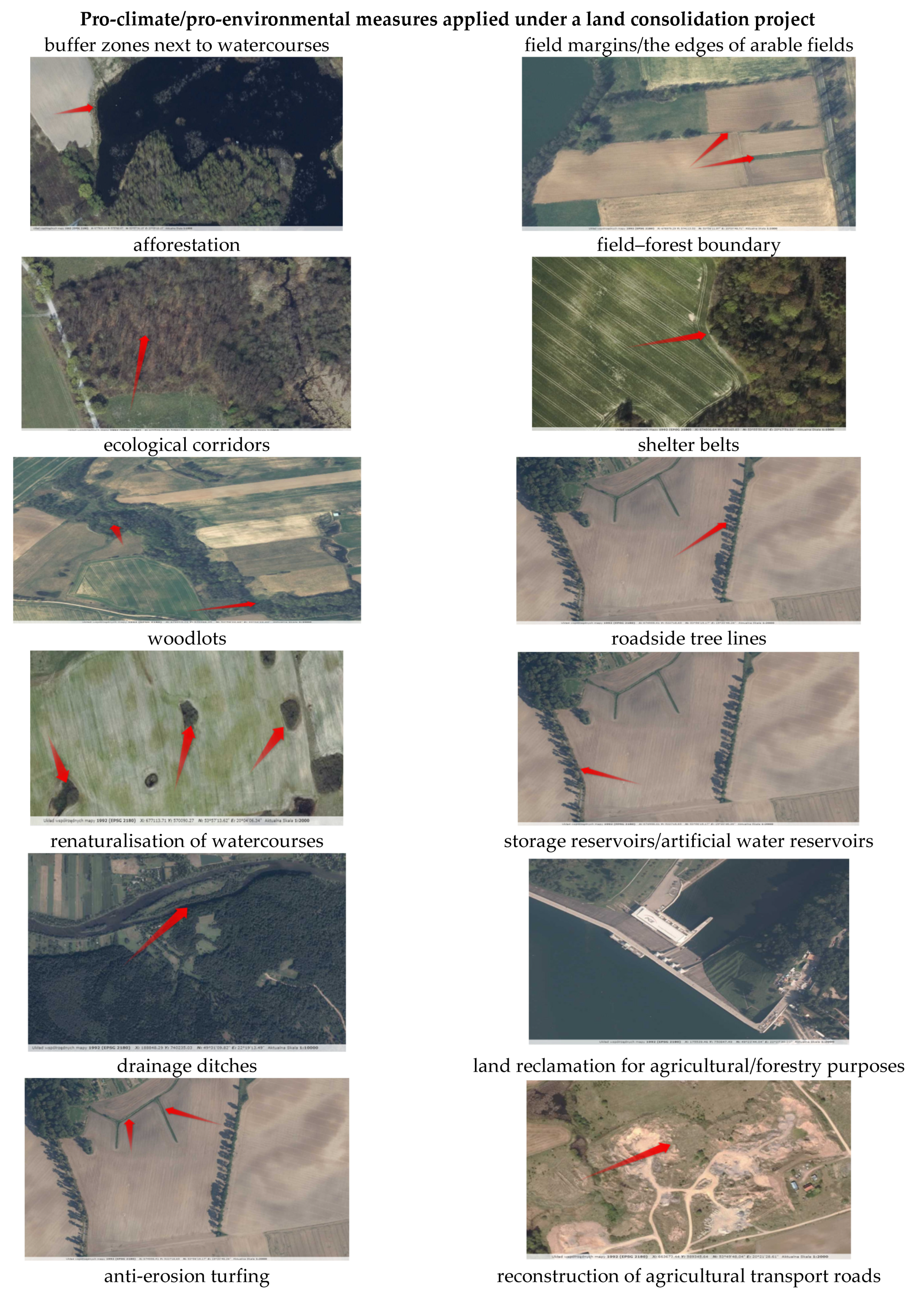
Figure 1. Components of pro-climate solutions implemented under land consolidation projects (the red arrow indicates the location of the pro-climate area). Source: authors’ study.
Sustainability 15 09306 g001aSustainability 15 09306 g001b
Figure 2. Research area. Source: [118].
Sustainability 15 09306 g002
Figure 3. The course of variation in indicators K1–K2, K7, K11.
Sustainability 15 09306 g003
Figure 4. Spatial distribution of K1, K2, K11, K7. Source: authors’ study.
Sustainability 15 09306 g004
Figure 5. The course of variation in indicators K4–K6.
Sustainability 15 09306 g005
Figure 6. Spatial distribution of K4, K5, K6. Source: authors’ study.
Sustainability 15 09306 g006aSustainability 15 09306 g006b
Figure 7. The course of variation in indicators K3, K8–K10.
Sustainability 15 09306 g007
Figure 8. Spatial distribution of K8, K9, K3, K10. Source: authors’ study.
Sustainability 15 09306 g008
Figure 9. The Eij index of the potential of a micro-location in terms of the implementation of a pro-climate solution in the objects where there is demand for land consolidation works. Source: authors’ study.
Sustainability 15 09306 g009
Figure 10. Spot chart of the global Moran’s for K1 and water-related (K1 + K2 + K3) indexes. Green points mark analyzed objects. Source: authors’ study.
Sustainability 15 09306 g010
Figure 11. Spot chart of the global Moran’s for trees-related (K6 + K7 + K9) indicators. Green points mark analyzed objects. Source: authors’ study.
Sustainability 15 09306 g011
Figure 12. Agricultural land use status before the Land and Property Register modernisation process [134].
Sustainability 15 09306 g012
Table 1. Basic parameters of the indicators under analysis.
ItemName of IndicatorSymbolUnitAver.Min.Max.Coefficient of Variation
1Improvement of the technical parameters of drainage ditchesK1km4.800.0014.1399.346
2Restoration of drainage ditchesK2km0.620.002.13132.965
3Reconstruction of pondsK3ha0.230.000.72134.989
4Adaptation of use to natural conditionsK4ha13.500.0047.94142.891
5Grassland maintenanceK5ha21.550.0044.0966.594
6Supplementation of forest vegetation in areas where the natural succession process has started—planned local afforestationK6ha9.550.0029.3494.433
7Trees in lineK7km1.660.003.3775.634
8Development of set-aside land for agricultural purposesK8ha0.700.003.52159.207
9Development of set-aside land for forestry purposesK9ha2.890.009.88126.778
10Wasteland reclamationK10ha1.610.004.3592.928
11Reconstruction/construction of agricultural transport roadsK11km10.930.0024.0768.615
Source: authors’ study.
Table 2. Summary of standardised K indicators.
ItemName of the ObjectSymbol of the ObjectFeatures
K1K2K3K4K5K6K7K8K9K10K11
1BrochocinA0.1460.0830.0000.0000.0540.0000.3491.0000.0190.1200.657
2GrodziecB0.3010.1110.0000.7571.0000.2210.6020.0000.9290.2800.617
3JadwisinC0.1300.0190.0000.0790.7430.2100.0001.0000.0000.0000.852
4ŁukaszówD0.0000.0000.0000.0000.0000.0000.0001.0000.0000.0511.000
5ModlikowiceE0.2240.0001.0001.0000.4530.2510.8091.0000.3221.0000.780
6OlszanicaF1.0000.5320.0000.8110.9031.0001.0000.8211.0000.3520.133
7RadziechówG0.3561.0000.5280.0250.3410.6340.6340.5370.2500.4550.367
8UniejowiceH0.8890.9140.0000.0000.4380.4990.4990.8520.2310.5220.547
9WojciechówI0.2810.0000.6940.0310.5090.1610.1611.0000.0990.0640.507
10ZagrodnoJ0.0710.2590.9170.1140.4470.2800.2800.7900.0790.8480.000
Source: authors’ study.
Table 3. Global Moran’s I for K1, K1-K2-K3, K6-K7-K9.
IndexesK1K1 + K2 + K3K6 + K7 + K9
Moran’s I Index−0.04553−0.075980.31791
Expected Index−0.11111−0.11111−0.11111
Variance0.034510.039820.03329
z-score−0.353860.176012.35126
p-value0.723440.860280.01871
Disclaimer/Publisher’s Note: The statements, opinions and data contained in all publications are solely those of the individual author(s) and contributor(s) and not of MDPI and/or the editor(s). MDPI and/or the editor(s) disclaim responsibility for any injury to people or property resulting from any ideas, methods, instructions or products referred to in the content.