Article

Smart(phone)-Monitoring (SPM): An Efficient and Accessible Method for Tracking Alien Plant Species

by
Lorenzo Pinzani
1,2,* and
Simona Ceschin
1,2
1
Department of Science, University of Roma Tre, Viale G. Marconi 446, 00146 Rome, Italy
2
NBFC—National Biodiversity Future Center, 90133 Palermo, Italy
*
Author to whom correspondence should be addressed.
Sustainability 2023, 15(12), 9814; https://doi.org/10.3390/su15129814
Submission received: 24 May 2023 / Revised: 16 June 2023 / Accepted: 18 June 2023 / Published: 20 June 2023
(This article belongs to the Special Issue Sustainable Urban Planning: Biodiversity, Greening, and Forestry)

Abstract

:
The invasion of alien plant species outside of their home range constitutes an emerging problem threatening native plant diversity. The expansion of alien species is often favored in anthropogenic habitats, such as roads and urbanized areas, which allow the rapid colonization of new sites by these species. The development of suitable monitoring methods is fundamental both to keep pace with the fast expansion dynamics of these species and to enable appropriate and prompt control strategies. In this work, an efficient, accessible, and cost-effective method for monitoring alien plants using a smartphone is proposed (smartphone-monitoring—SPM). Using smartphones with a geolocation system, geographic coordinates of images matched to single plant records can be easily acquired and structured into exportable databases in a few steps. We tested the SPM method on three black-listed alien plants, Ailanthus altissima (Mill.) Swingle, Arundo donax L., and Robinia pseudoacacia L., along the road network and in major urban centers of the Tuscany region (central Italy).

1. Introduction

Alien plant species are those species whose presence outside of their home range is attributable to human actions, deliberate or inadvertent, that enabled them to overcome biogeographical barriers [1,2]. A subset of these, which spread rapidly over considerable distances from their introduction sites, are defined as invasive alien species (IAS) [3,4].
IAS have been identified as a growing threat to ecosystem conservation, environmental quality, and native biodiversity [5,6]. According to the Intergovernmental Science-Policy Platform on Biodiversity and Ecosystem Services [7], about one-fifth of the earth’s surface is threatened by biological invaders. Moreover, high-income countries record 30 times greater number of IAS in comparison to low-income ones [8]. This trend can be attributed to a denser network of communication, trade, and transport routes (by sea, air, land) in countries with high-level urbanization.
Transportation lines, such as roads, railways and hiking paths, can be critical dispersal routes for invasive alien plant species (IAPS). Indeed, they can act as preferential corridors for the dispersion of seeds and propagules that can be transported even over long distances [9] via drainage channels [10] or transit vehicles [11]. In addition, roadsides, and more generally urbanized environments characterized by recurrent anthropic disturbance, promote the establishment of alien invasive plants, through environmental alteration and instability [12,13]. For example, a study performed at the county level throughout China [14] showed that major human-related vectors (i.e., railways roads and general human activities) are among the biggest contributors to the spread of the worst IAPS in the country.
High-quality monitoring and data collection activities are crucial for effective IAPS management and control [15]. Existing approaches for plant data collection require time and resources, and the results of such surveys are often obtained too slowly [16], not allowing for the timely control of target alien species [17]. In fact, they often arrive too late after the alien plants have already spread assuming the nature of invasive species. In this context, monitoring should require the development of methodologies capable of keeping pace with the rapid colonization of new sites by alien species.
Therefore, an efficient, accessible, and cost-effective monitoring for IAPS would represent an important advance toward the mitigation of the negative effects exerted by these species on ecosystems.
Remote sensing is an emerging method for detecting invasive plant species [18,19]. In particular, drones and other unmanned aerial vehicles (UAVs) offer valuable solutions in monitoring local areas with a high spatial and temporal resolution [20,21]. However, alien species that are distributed along roads are impractical to monitor using UAVs due to regulations that prevent aerial transit over roads, as well as fuel restrictions.
Car surveying along roads is a successful approach for monitoring IAPS [22,23,24,25,26]. One of the main advantages of this approach, when compared to traditional on-foot floristic surveys, is that it allows records of plant species covering larger areas in shorter periods and with few resources [26,27,28]. However, the techniques adopted are diverse, and there is no reference method for data acquisition. Moreover, for example, McDougall et al. [24] sampled twenty locations along the roads of seven different regions worldwide recording alien plants visible from a moving vehicle every 5 km interval without thus being able to provide a complete mapping of the road section traveled. In contrast, Abella et al. [22] sampled along 0.16 km increments using a GPS system but while having to stop their car frequently along the road. McAvoy et al. [23] sampled continuously along incremental stretches of 1.6 km but using odometer and roadside markers, and not GPS, for record positioning, thus providing a potentially inaccurate or biased estimate of the location.
Recently, Dyrmann et al. [29] proposed a method to automate the registration of IAPS along roads using high-resolution images processed automatically through deep learning algorithms. Although this approach looks promising, it requires specialized equipment, high computational power, and an adequate level of expertise from the operator for data acquisition and processing. These aspects may constitute potential limitations for the application of these approaches on a broader scale.
In this context, the availability of a method that is accessible, intuitive, but also sufficiently accurate could be a step forward for the dissemination of IAPS-monitoring systems along roads and in urbanized areas.
In recent years, smartphones have become supporting tools for scientific data collection, in particular as a result of “citizen science” initiatives, which is “the engagement of non-professionals in scientific investigations” [30]. Although citizen science exists from time, it has seen a recent surge in popularity due to advances in information and communications technology (ICT) [30], including smartphones equipped with cameras, GPS, and internet connectivity. The use of ICT has made it much easier for citizen volunteers to interact with professional scientists and to generate data, e.g., through web interfaces or mobile applications [30,31,32]. The data collected through these initiatives have been recognized as having great potential to contribute to biodiversity research due to the high number of species observations that can be collected by the public [33,34,35].
The positioning accuracy of modern smartphones is very promising. Menard et al. [36] compared three different types of smartphones, finding an accuracy of GPS positioning within 10 m in 98% of cases. Merry and Bettinger [37] tested the positioning accuracy of a modern smartphone in an urban environment, finding a positioning error between 7 and 13 m, consistent with the observed general accuracy levels of recreation-grade GPS receivers in potential high-multipath environments (i.e., urban areas).
Moreover, modern smartphones normally incorporate GPS and Wi-Fi receivers plus a wide variety of digital sensors that may include, for example, microphones, touch and image sensors, three-axis MEMS (micro-electromechanical systems) accelerometers, tilt sensors, gyroscopes, digital compasses, barometric sensors, and proximity sensors [38].
Compared with conventional GPS data loggers for tracking and trip recording, the additional sensors of smartphones can be employed to bridge the loss of lock of GPS signals, providing a more reliable and continuous positioning solution, especially in urban environments [39].
Here, we propose a method of roadside monitoring of IAPS, which combines the rapidity offered by car surveying with the accessibility and spatial accuracy of GPS systems integrated into modern smartphones, to produce exportable geo-datasets of plant species occurrences (smartphone-monitoring method—SPM). This method aims to (i) locate the onset of new IAPS nuclei (promoting their timely management) and (ii) map the distribution of IAPS in anthropogenic environments, identifying the most critical invasion areas to help define priorities for management interventions.
The SPM method was tested on three widely known IAPS, Ailanthus altissima (Mill.) Swingle, Arundo donax L., and Robinia pseudoacacia L., detected for 10 months along the road network and in major urban centers of the Tuscany region (central Italy). Results relating to these three IAPS are presented to illustrate the effectiveness of this method as a useful tool in tracking the invasion pathways of alien species along the road network of a wide territory.

2. Materials and Methods

2.1. Device Technical Specification
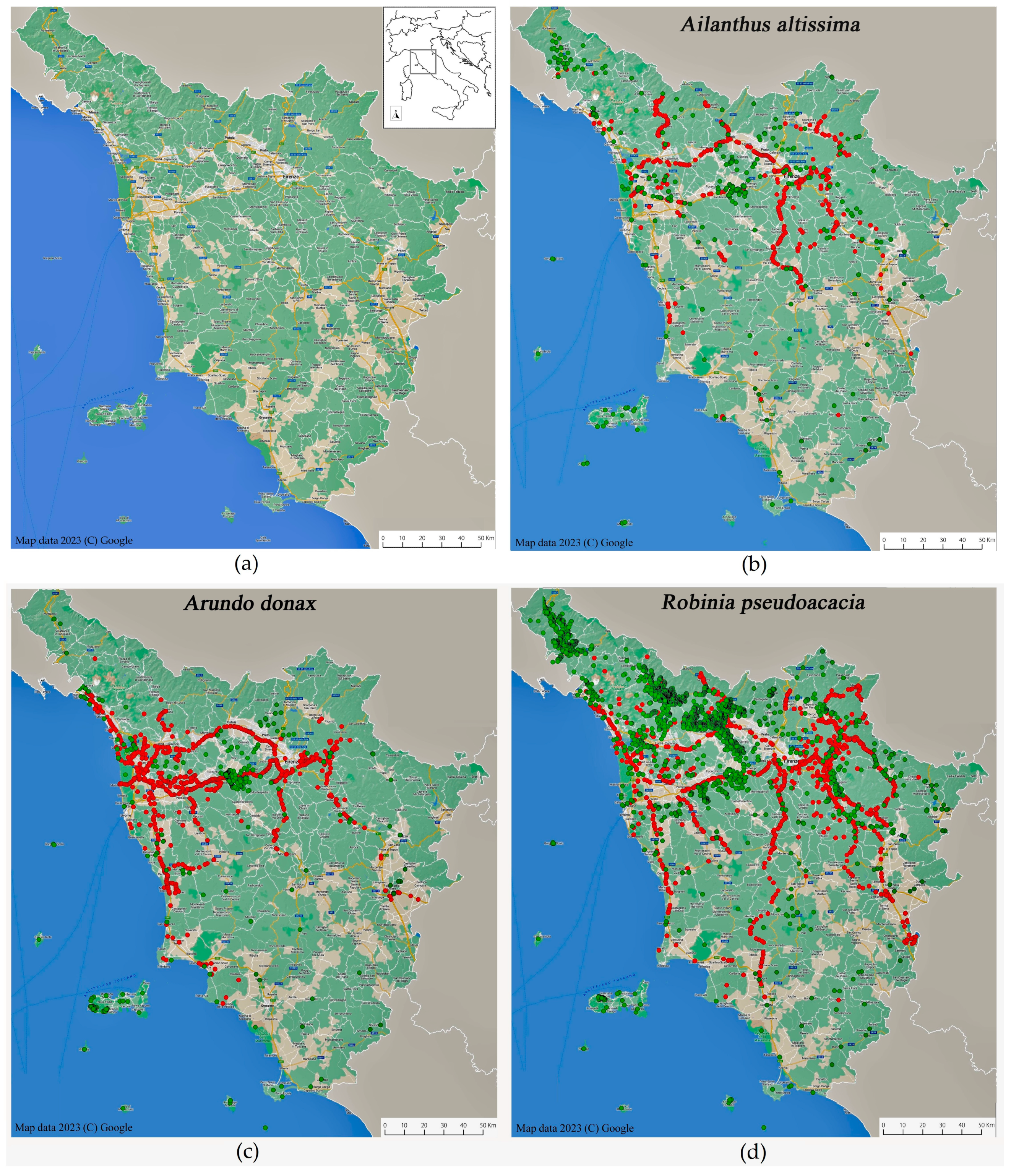
The SPM method is applicable for all smartphones equipped with photo geotagging. In the present study, an iOS-based smartphone device (iPhone SE, Model A2296, iOS 16.4.1; Apple) was used. The relevant technical specifications include GPS (Global Positioning System), GLONASS (Global Navigation Satellite System), Galileo, QZSS (Quasi-Zenith Satellite System), BDS (BeiDou location systems), Wi-Fi (Wireless Fidelity), accelerometer, barometer, digital compass, iBeacon micro-location, 12MP main camera, and photo geotagging.

2.2. Study Area

The region of Tuscany (central Italy) represents an ideal study area for testing the SPM method because it combines a rich road and urban network with a good prior floristic knowledge, allowing to evaluate the effectiveness of the SPM method in obtaining new data of alien species in a floristically well-known area.
Tuscany is the fifth largest region in Italy (about 23,000 km2) with about 3.6 million inhabitants [40]. The population is concentrated in the major urban centers distributed in the northern flat portions. The regional surface is covered by a dense road network comprising 2800 km of roads (400 km of highways, 900 km of main roads, and 1.450 km of local roads) fully covering the regional area (Figure 1a) [41]. Highways are about 24 m wide and have paved banks at the edges subjected to periodical mowing. Main roads are about 14 m wide and have often unpaved banks subjected to periodical mowing. Local roads can be about 7 m wide or less, and they can or cannot be equipped with banks.
The Tuscany region has a long floristic tradition, testified by the numerous contributions published over the years for the entire territory [42]. The floristic information of the region is currently stored in “Wikiplantbase#Toscana” [43], an online platform collecting and continuously updating the full set of georeferenced floristic records for Tuscany. This platform is part of a larger project to create a freely accessible online national floristic database [44]. Known records of the selected alien species were downloaded from Wikiplantbase#Toscana on 15 December 2022.

2.3. Case Study

Data collection was performed over 10 months between January and October 2022 along about 1000 km of Tuscan roads (approx. 35% of the entire regional road network) including the most urbanized areas. The survey consisted of the georeferenced image acquisition of three alien plant species: Ailanthus altissima, Arundo donax, and Robinia pseudoacacia. These alien species were selected because they have a high ecosystem impact and are conspicuous, easily identifiable, and are known to be capable of quickly expanding in anthropogenic environments. In addition, their wide and known distribution across Tuscany [43] allows for adequate comparison with data acquired by the method proposed here. Nevertheless, there are currently no floristic studies for these species targeted upon the Tuscan road network, given the poor accessibility (often lack of sidewalks) and riskiness of this context for traditional sampling. Therefore, prior distributional data for the selected species cannot be used to test the accuracy of the new data nor to determine geographic or temporal trends of the species investigated but rather are used to highlight and fill distributional gaps and to test the effectiveness of the method in acquiring spatially accurate occurrence points in a relatively short time.

2.3.1. Ailanthus altissima

Ailanthus altissima (tree of heaven), a tree native to Southeast Asia, is considered one of the worst invasive plant species in the world [45]. In Europe, A. altissima was introduced in the 1740s [46] and currently is widely established [45]. Seeds, included in a typically winged fruit (samara), are dispersed long distances from the parent plant, especially by wind but also by water and road traffic that are used as secondary dispersal mechanisms [47]. Ailanthus altissima is native to subtropical/warm temperate climates but is also able to invade cool temperate and tropical climates. In Europe, it colonizes disturbed sites along roads and ditches, particularly in the Mediterranean region, including Italy. It negatively impacts the environment by altering the local vegetation structure and severely compromising ecosystem stability [48]. In Tuscany, A. altissima is highly widespread and considered a serious alien invasive plant [49].

2.3.2. Arundo donax

Arundo donax (giant reed) is listed as one of the world’s 100 worst invasive alien species [50]. It is probably native to the tropical and temperate regions of Eurasia, but due to the ancient cultivation of the species in many areas of the world, its home range is not yet clearly known [51]. It has been introduced in several warm countries worldwide but is considered an invasive species mainly in subtropical or Mediterranean climates [51]. A species strongly competitive with native plants, especially for access to water in the soil, it drastically alters ecosystem balances and functions, often producing extensive, compact, monospecific populations up to 8 m high. Since A. donax is highly flammable, it can also alter fire regimes in invaded areas, especially in the warm zones of the Mediterranean area [52]. In the Mediterranean Basin, including Italy and the study area, this species is considered as an archaeophyte invasive species (i.e., species introduced before 1500 AD) [49,53].

2.3.3. Robinia pseudoacacia

The American Robinia pseudoacacia (black locust) is listed among the 40 most invasive woody plants globally [54], and it was introduced into Europe at the beginning of the 17th century for ornamental purposes [55]. Here, it has assumed a highly invasive nature in several countries [56], making it included on national blacklists across Europe, e.g., [49,57,58]. It propagates easily by seed and root suckers, and in its North American home range invades disturbed woodlands and rural and urban landscapes [59]. Robinia pseudoacacia competes successfully with native species for natural resources and produces extensive monospecific populations [60,61]. In Tuscany, R. pseudoacacia is widespread and considered an alien invasive plant species to be controlled [49].

2.4. SPM Method Workflow

The data collection protocol of the SPM method consisted of two main steps: (i) the acquisition using smartphones of georeferenced images corresponding to alien plant occurrence along roads, (ii) metadata extraction, data filtering, and data mapping.

2.4.1. Georeferenced Image Acquisition

Two operators (driver and recorder) were required to perform image acquisition. The images were acquired from the car in all three categories of roadway (highways, main roads, and local roads) through both urban and rural environments at a speed between 30 and 90 km/h depending on the road category traveled. Image acquisition was not aimed at photographing the target species along the road sections but was rather necessary for the acquisition of geographic coordinates connected to the image and consequently to plant species occurrence. For the georeferencing of the acquired images, smartphone geotagging was required. Images were taken while driving whenever the target species was observed, keeping the camera active.
The identification of the target species was carried out in real time by the recorder. This activity requires a good knowledge of the target species to allow its reliable identification in real time while the car is moving. To minimize misidentification and geographic positioning errors, the presence of the selected species was detected within a range of approximately 10 m on each side of the road.
Each time an image was acquired, the smartphone recorded a set of information as metadata. To facilitate image acquisition, an economical Bluetooth remote control was used to take pictures without the need to frequently handle the smartphone. To ensure optimal monitoring on wide roads with two-way traffic (e.g., highways), it is recommended to drive along the road section in both directions, as the roadside furthest from the car is generally difficult to monitor well. Where the target species occurred very frequently along the investigated road section, images were acquired at high frequency, without leaving any undetected road stretches. Then, all acquired data were filtered and analyzed in the next phase by checking for position accuracy and setting minimum distances between the records to be considered.

2.4.2. Metadata Extraction and Data Filtering

Once the image acquisition phase was completed, the images were transferred to a computer for metadata extraction. Metadata extraction was performed using the read_exif() function of the ‘exifr’ package [62] in the R statistical environment [63]. This function reads EXIF data and returns results as a data frame. For the specific case study, the minimum appropriate information for the complete georeferencing of images was selected (Table 1).
Subsequently, the acquired data were filtered according to two spatial criteria: (1) by eliminating records for which a GPS positioning error greater than 100 m was associated to the metadata of the correspondent acquired image, and (2) by inspecting the spatial correspondence between records and the road network traveled, excluding the records located outside the road route.
Species records were filtered considering a minimum distance between consecutive records of approximately 100 m; this distance was considered as an appropriate compromise between the GPS positioning accuracy of the device used and the need to accurately monitor the species along the road section. When two consecutive records are closer than 100 m, the second one was not considered.

3. Results

The SPM of the three target alien species resulted in a total of 2687 species records, of which about 500 were discarded because they did not meet the selection criteria (371 records discarded by minimum distance criterion and 131 by positioning error). A final dataset of 2185 records was produced from the 10-month floristic monitoring activity. In particular, there were 413 occurrences recorded for A. altissima (Figure 1b), 730 for A. donax (Figure 1c), and 1042 for R. pseudoacacia (Figure 1d) (Table S1).
Comparing the total number of records collected in the study area for these three alien species through SPM with those known from the literature [43], the overall regional number of records available for these three alien species increases significantly by 67%; specifically, this increase is 138% for A. altissima, 295% for A. donax, and 39% for R. pseudoacacia (Table 2).
Table 2. Number of occurrences known for the study area based on Wikiplantbase#Toscana [43] and collected through the SPM method for the three target alien species.
Alien SpeciesWikiplantbase#ToscanaSPM
Ailanthus altissima298413
Arundo donax247730
Robinia pseudoacacia27021042
Figure 1. The road network of Tuscany including highways and main roads (yellow), and local roads (white) (a); distribution of Ailanthus altissima (b), Arundo donax (c), and Robinia pseudoacacia (d) in Tuscany along the road network. Green dots represent species occurrence based on known records downloaded from Wikiplantbase#Toscana [39] on 15 December 2022; red dots represent new species occurrence collected by the SPM method between January and October 2022.
Sustainability 15 09814 g001

4. Discussion

The potential of the SPM method is evident when comparing the amount of floristic data collected by traditional monitoring methods and the proposed one. Thus, compared to the total number of records reported for the study area for A. altissima, A. donax, and R. pseudoacacia [43], the use of the SPM method significantly increases the total number of occurrence records for these three alien species in the study area with new spatially and temporally accurate data. It should be noted that many of the SPM data collected do not overlap with the already large amount of previous known data for the three selected species, underlining how insufficient floristic exploration along roads and in urban areas has been to date in Tuscany despite the good floristic knowledge of the region [42]. This knowledge gap becomes even more relevant in the context of biological invasions, considering that anthropogenic habitats such as roads are known to be preferential biological corridors for the spread of alien plants [9,10,64].
On one hand, this floristic gap could be a result of the poor accessibility and danger of many roads (not having sidewalks) inhibiting traditional floristic surveys carried out by foot. On the other hand, floristic studies have usually focused on small-scale natural systems generating “islands” of knowledge separated by heavily neglected areas. In the context of invasive alien species, a small-scale approach rarely provides comprehensive insight into the complexities of biological invasions at the macroscale [65]. Unlike traditional floristic monitoring, the SPM method can overcome these limitations by quickly and safely collecting data over extensive continuous geographic areas. The SPM method is therefore useful for filling distribution gaps of alien species in poorly accessible, disturbed, and neglected contexts, such as roadsides.
In comparison with more advanced integrated monitoring systems with automatic image recognition, i.e., [29], the SPM method does not rely on the image of the monitored plant species, and therefore, it requires neither the use of an advanced instrumentation for acquiring high-definition images during vehicle movement nor powerful software to process the collected data. On the other hand, the reliability of species identification is left to the botanical expertise of the operator.
A major strength of the method is the combination of the intuitiveness of the smartphone and the excellent performance provided by its technology that can be exploited for the purpose of floristic monitoring, especially in urban and street environments. In fact, modern smartphones are common tools, now integrated into most people’s daily lives, that do not require a high technical skill from the user and are endowed with high spatial accuracy and good satellite coverage. Conversely, the use of professional Global Positioning System (GPS) devices requires greater technical expertise as well as an additional expense for the acquisition of the device for monitoring purposes.
Concerning the data spatial accuracy of smartphones, it should be noted that from the original dataset (2700 records), only less than 5% of the records showed a GPS positioning error greater than 100 m, while about 90% of the records reported a positioning error of less than 10 m.This would support the high accuracy of smartphones already reported in previous studies, e.g., [36,37,39], showing a positioning accuracy around 10 m, consistent with recreation-grade GPS receivers.
An important limitation of traditional car survey monitoring systems is that often using them it is not possible to distinguish between undetected areas and true absences at the time of survey [35]. Thus, the absence of a species from an area could be because that area was not monitored at all, as well as the actual absence of the species in that area. According to the method presented, this problem is solved indirectly because along the entire road stretch studied, the records were systematically acquired and indicated the presence of the species. For this reason, road stretches where the species was not recorded can be considered areas of true absence.
Using the SPM method, while punctually signaling the record of a target species, neither its phenological state nor its local abundance can be recorded. This means that when the single occurrence of a species is recorded, from that record taken, it is not possible to distinguish whether that species presents with an early or mature phenological stage, and with single individuals or more nuclei that are extensive. Nevertheless, it is possible to obtain an indirect estimate of the abundance of a species by determining the density of records along the stretch of road traveled during monitoring.
Compared to the use of GPS devices for georeferencing data, the prolonged use of the camera limits the autonomy of the smartphone battery in the absence of recharging sources, whereas in professional GPS devices, the battery is more durable as they are optimized for prolonged use.
Finally, it is worth noting that the SPM method is effectively applicable on plant species that are easily identifiable from a moving car and are therefore conspicuous and easily visible.

5. Conclusions

The proposed method proves to be a valuable and innovative monitoring tool in the context of biological invasions by tracking the occurrence of highly invasive plant species along the road and urban network of a vast territory, such as the one investigated. Reproducibility, accessibility, and expeditiousness make the SPM method easily exportable, widely usable, and adaptable to different environmental contexts and geographical areas.

Supplementary Materials

The following supporting information can be downloaded at https://www.mdpi.com/article/10.3390/su15129814/s1, Table S1: table of occurrences.

Author Contributions

Conceptualization, L.P.; methodology, L.P.; validation, S.C.; formal analysis, L.P.; investigation, L.P.; resources, L.P.; data curation, L.P.; writing—original draft preparation, L.P.; writing—review and editing, L.P. and S.C.; visualization, L.P. and S.C.; supervision, S.C. All authors have read and agreed to the published version of the manuscript.

Funding

This research did not receive any specific external funding.

Institutional Review Board Statement

Not applicable.

Informed Consent Statement

Not applicable.

Data Availability Statement

Not applicable.

Acknowledgments

The authors acknowledge the support of NBFC to Department of Science—University of Roma Tre, funded by the Italian Ministry of University and Research, PNRR, Missione 4 Componente 2, “Dalla Ricerca all’Impresa”, Investimento 1.4, Project CN00000033.

Conflicts of Interest

The authors declare no conflict of interest. The funders had no role in the design of the study; in the collection, analysis, or interpretation of data; in the writing of the manuscript; or in the decision to publish the results.

References

  1. Richardson, D.M.; Pyšek, P.; Carlton, J.T. A compendium of essential concepts and terminology in biological invasions. In Fifty Years of Invasion Ecology: The Legacy of Charles Elton; Richardson, D.M., Ed.; Blackwell Publishing: Oxford, UK, 2011; pp. 409–420. [Google Scholar]
  2. Essl, F.; Bacher, S.; Genovesi, P.; Hulme, P.E.; Jeschke, J.M.; Katsanevakis, S.; Kowarik, I.; Kühn, I.; Pyšek, P.; Rabitsch, W.; et al. Which taxa are alien? Criteria, applications, and uncertainties. BioScience 2018, 68, 496–509. [Google Scholar] [CrossRef] [Green Version]
  3. Occhipinti-Ambrogi, A.; Galil, B.S. A uniform terminology on bioinvasions: A chimera or an operative tool? Mar. Pollut. Bull. 2004, 49, 688–694. [Google Scholar] [CrossRef] [PubMed]
  4. Blackburn, T.M.; Pyšek, P.; Bacher, S.; Carlton, J.T.; Duncan, R.P.; Jarošík, V.; Wilson, J.R.U.; Richardson, D.M. A proposed unified framework for biological invasions. Trends Ecol. Evol. 2011, 26, 333–339. [Google Scholar] [CrossRef] [Green Version]
  5. Bartz, R.; Kowarik, I. Assessing the environmental impacts of invasive alien plants: A review of assessment approaches. NeoBiota 2019, 43, 69–99. [Google Scholar] [CrossRef] [Green Version]
  6. Rai, P.K.; Singh, J.S. Invasive alien plant species: Their impact on environment, ecosystem services and human health. Ecol. Indic. 2020, 111, 106020. [Google Scholar] [CrossRef]
  7. IPBES. Global Assessment Report on Biodiversity and Ecosystem Services of the Intergovernmental Science-Policy Platform on Biodiversity and Ecosystem Services; Brondizio, E.S., Settele, J., Díaz, S., Ngo, H.T., Eds.; IPBES Secretariat: Bonn, Germany, 2019; 1148p. [Google Scholar] [CrossRef]
  8. Seebens, H.; Blackburn, T.M.; Dyer, E.E.; Genovesi, P.; Hulme, P.E.; Jeschke, J.M.; Pagad, S.; Pyšek, P.; van Kleunen, M.; Winter, M.; et al. Global rise in emerging alien species results from increased accessibility of new source pools. Proc. Natl. Acad. Sci. USA 2018, 115, E2264–E2273. [Google Scholar] [CrossRef] [Green Version]
  9. Dar, P.A.; Reshi, Z.A.; Shah, M.A. Roads act as corridors for the spread of alien plant species in the mountainous regions: A case study of Kashmir Valley, India. Trop. Ecol. 2015, 56, 183–190. [Google Scholar]
  10. Wilcox Douglas, A. Migration and control of purple loosestrife (Lythrum salicaria L.) along highway corridors. Environ. Manag. 1989, 13, 365–370. [Google Scholar] [CrossRef]
  11. Lemke, A.; Kowarik, I.; Von der Lippe, M. How traffic facilitates population expansion of invasive species along roads: The case of common ragweed in Germany. J. Appl. Ecol. 2019, 56, 413–422. [Google Scholar] [CrossRef]
  12. Hansen, M.J.; Clevenger, A.P. The influence of disturbance and habitat on the presence of non-native plant species along transport corridors. Biol. Conserv. 2005, 125, 249–259. [Google Scholar] [CrossRef]
  13. Christen, D.C.; Matlack, G.R. The habitat and conduit functions of roads in the spread of three invasive plant species. Biol. Invasions 2009, 11, 453–465. [Google Scholar] [CrossRef]
  14. Horvitz, N.; Wang, R.; Wan, F.H.; Nathan, R. Pervasive human-mediated large-scale invasion: Analysis of spread patterns and their underlying mechanisms in 17 of China’s worst invasive plants. J. Ecol. 2017, 105, 85–94. [Google Scholar] [CrossRef]
  15. Groom, Q.J.; Adriaens, T.; Desmet, P.; Simpson, A.; De Wever, A.; Bazos, I.; Cardoso, A.C.; Charles, L.; Christopoulou, A.; Gazda, A.; et al. Recommendations to make your invasive alien species data more useful. Front. Appl. Math. Stat. 2017, 3, 13. [Google Scholar] [CrossRef] [Green Version]
  16. Adriaens, T.; Sutton-Croft, M.; Owen, K.; Brosens, D.; van Valkenburg, J.; Kilbey, D.; Groom, Q.; Ehmig, C.; Thürkow, F.; Van Hende, P.; et al. Trying to engage the crowd in recording invasive alien species in Europe: Experiences from two smartphone applications in northwest Europe. Manag. Biol. Invasions 2015, 6, 215. [Google Scholar] [CrossRef] [Green Version]
  17. Groom, Q.J.; Desmet, P.; Vanderhoeven, S.; Adriaens, T. The importance of open data for invasive alien species research, policy and management. Manag. Biol. Invasions 2015, 6, 119–125. [Google Scholar] [CrossRef] [Green Version]
  18. Niphadkar, M.; Nagendra, H. Remote sensing of invasive plants: Incorporating functional traits into the picture. Int. J. Remote Sens. 2016, 37, 3074–3085. [Google Scholar] [CrossRef]
  19. James, K.; Bradshaw, K. Detecting plant species in the field with deep learning and drone technology. Methods Ecol. Evol. 2020, 11, 1509–1519. [Google Scholar] [CrossRef]
  20. Dvořák, P.; Müllerová, J.; Bartaloš, T.; Brůna, J. Unmanned aerial vehicles for alien plant species detection and monitoring. Int. Arch. Photogramm. Remote Sens. Spat. Inf. Sci.—ISPRS Arch. 2015, 41, 83–90. [Google Scholar] [CrossRef] [Green Version]
  21. Dash, J.P.; Watt, M.S.; Paul, T.S.; Morgenroth, J.; Hartley, R. Taking a closer look at invasive alien plant research: A review of the current state, opportunities, and future directions for UAVs. Methods Ecol. Evol. 2019, 10, 2020–2033. [Google Scholar] [CrossRef] [Green Version]
  22. Abella, S.R.; Spencer, J.E.; Hoines, J.; Nazarchyk, C. Assessing an exotic plant surveying program in the Mojave Desert, Clark County, Nevada, USA. Environ. Monit. Assess. 2009, 151, 221–230. [Google Scholar] [CrossRef]
  23. McAvoy, T.; Snyder, A.; Johnson, N.; Salom, S.; Kok, L. Road survey of the invasive tree-of-heaven (Ailanthus altissima) in Virginia. Invasive Plant Sci. Manag. 2012, 5, 506–512. [Google Scholar] [CrossRef]
  24. McDougall, K.L.; Lembrechts, J.; Rew, L.J.; Haider, S.; Cavieres, L.A.; Kueffer, C.; Milbau, A.; Naylor, B.J.; Nuñez, M.A.; Pauchard, A.; et al. Running off the road: Roadside non-native plants invading mountain vegetation. Biol. Invasions 2018, 20, 3461–3473. [Google Scholar] [CrossRef] [Green Version]
  25. Kraaij, T.; Baard, J.A. Use of a rapid roadside survey to detect potentially invasive plant species along the Garden Route, South Africa. Koedoe 2019, 61, 10. [Google Scholar]
  26. Barone, G.; Domina, G.; Di Gristina, E. Comparison of different methods to assess the distribution of alien plants along the road network and use of Google Street View panoramas interpretation in Sicily (Italy) as a case study. Biodivers. Data J. 2021, 9, e66013. [Google Scholar] [CrossRef] [PubMed]
  27. Shuster, W.D.; Herms, C.P.; Frey, M.N.; Doohan, D.J.; Cardina, J. Comparison of survey methods for an invasive plant at the subwatershed level. Biol. Invasions 2005, 7, 393–403. [Google Scholar] [CrossRef]
  28. Catry, F.X.; Moreira, F.; Deus, E.; Silva, J.S.; Águas, A. Assessing the extent and the environmental drivers of Eucalyptus globulus wildling establishment in Portugal: Results from a countrywide survey. Biol. Invasions 2015, 17, 3163–3181. [Google Scholar] [CrossRef]
  29. Dyrmann, M.; Mortensen, A.K.; Linneberg, L.; Høye, T.T.; Bjerge, K. Camera assisted roadside monitoring for invasive alien plant species using deep learning. Sensors 2021, 21, 6126. [Google Scholar] [CrossRef] [PubMed]
  30. Miller-Rushing, A.; Primack, R.; Bonney, R. The history of public participation in ecological research. Front. Ecol. Environ. 2012, 10, 285–290. [Google Scholar] [CrossRef]
  31. Goodchild, M.F. Citizens as sensors: The world of volunteered geography. GeoJournal 2007, 69, 211–221. [Google Scholar] [CrossRef] [Green Version]
  32. Kobori, H.; Dickinson, J.L.; Washitani, I.; Sakurai, R.; Amano, T.; Komatsu, N.; Kitamura, W.; Takagawa, S.; Koyama, K.; Ogawara, T.; et al. Citizen science: A new approach to advance ecology, education, and conservation. Ecol. Res. 2016, 31, 1–19. [Google Scholar] [CrossRef] [Green Version]
  33. Chandler, M.; See, L.; Copas, K.; Bonde, A.M.; López, B.C.; Danielsen, F.; Legind, J.K.; Masinde, S.; Miller-Rushing, A.J.; Newman, G.; et al. Contribution of citizen science towards international biodiversity monitoring. Biol. Conserv. 2017, 213, 280–294. [Google Scholar] [CrossRef] [Green Version]
  34. Klemann-Junior, L.; Villegas Vallejos, M.A.; Scherer-Neto, P.; Vitule, J.R.S. Traditional scientific data vs. uncoordinated citizen science effort: A review of the current status and comparison of data on avifauna in Southern Brazil. PLoS ONE 2017, 12, e0188819. [Google Scholar] [CrossRef] [PubMed] [Green Version]
  35. Bradter, U.; Mair, L.; Jönsson, M.; Knape, J.; Singer, A.; Snäll, T. Can opportunistically collected Citizen Science data fill a data gap for habitat suitability models of less common species? Methods Ecol. Evol. 2018, 9, 1667–1678. [Google Scholar] [CrossRef]
  36. Menard, T.; Miller, J.; Nowak, M.; Norris, D. Comparing the GPS capabilities of the Samsung Galaxy S, Motorola Droid X, and the Apple iPhone for vehicle tracking using FreeSim_Mobile. In Proceedings of the 14th International IEEE Conference on Intelligent Transportation Systems (ITSC), Washington, DC, USA, 5–7 October 2011. [Google Scholar] [CrossRef]
  37. Merry, K.; Bettinger, P. Smartphone GPS accuracy study in an urban environment. PLoS ONE 2019, 14, e0219890. [Google Scholar] [CrossRef] [PubMed] [Green Version]
  38. Premier Farnell UK Limited. Sensors for Smartphone and Tablet. 2022. Available online: http://uk.farnell.com/smartphonetechnology-applications (accessed on 15 December 2022).
  39. Mok, E.; Retscher, G.; Wen, C. Initial test on the use of GPS and sensor data of modern smartphones for vehicle tracking in dense high rise environments. In Proceedings of the Ubiquitous Positioning, Indoor Navigation, and Location Based Service (UPINLBS), Helsinki, Finland, 3–4 October 2012. [Google Scholar] [CrossRef]
  40. ISTAT (Italian National Institute of Statistics). Population in Italy. Available online: http://www.demo.istat.it (accessed on 12 February 2023).
  41. ANAS (Azienda Nazionale Autonoma delle Strade Statali). Available online: https://www.stradeanas.it/it/le-strade/anas-regione (accessed on 15 December 2022).
  42. Angiolini, C.; Arrigoni, P.V.; Selvi, F. Stato attuale e progressi delle conoscenze floristiche in Toscana dal 1978 a oggi. In Stato delle Conoscenze della Flora Vascolare d’Italia; Scoppola, A., Blasi, C., Eds.; Palombi: Roma, Italy, 2005; pp. 141–145. [Google Scholar]
  43. Peruzzi, L.; Bedini, G. (Eds.) Wikiplantbase #Toscana. 2013. Available online: http://bot.biologia.unipi.it/wpb/toscana/index.html (accessed on 12 February 2023).
  44. Peruzzi, L.; Roma-Marzio, F.; Pinzani, L.; Bedini, G. (Eds.) Wikiplantbase #Italia. 2019. Available online: http://bot.biologia.unipi.it/wpb/italia (accessed on 12 February 2023).
  45. GBIF. Ailanthus altissima (Mill.) Swingle in GBIF Secretariat. GBIF Backbone Taxonomy. Checklist Dataset. 2022. Available online: https://www.gbif.org/species/7615579 (accessed on 12 February 2023).
  46. Hu, S.Y. Ailanthus. Arnoldia 1979, 39, 29–50. [Google Scholar]
  47. Kaproth, M.A.; McGraw, J.B. Seed viability and dispersal of the wind-dispersed invasive Ailanthus altissima in aqueous environments. For. Sci. 2008, 54, 490–496. [Google Scholar]
  48. Constán-Nava, S.; Bonet, A. Genetic variability modulates the effect of habitat type and environmental conditions on early invasion success of Ailanthus altissima in Mediterranean ecosystems. Biol. Invasions 2012, 14, 2379–2392. [Google Scholar] [CrossRef]
  49. Celesti-Grapow, L.; Alessandrini, A.; Arrigoni, P.V.; Banfi, E.; Bernardo, L.; Bovio, M.; Brundu, G.; Cagiotti, M.R.; Camarda, I.; Carli, E.; et al. Inventory of the non-native flora of Italy. Plant Biosyst. 2009, 143, 386–430. [Google Scholar] [CrossRef]
  50. Rojas-Sandoval, J.; Acevedo-Rodríguez, P. Arundo donax (giant reed), CABI Compendium. CABI International. 2014. Available online: https://www.cabidigitallibrary.org/doi/10.1079/cabicompendium.1940 (accessed on 15 December 2022).
  51. Jiménez-Ruiz, J.; Hardion, L.; Del Monte, J.P.; Vila, B.; Santín-Montanyá, M.I. Monographs on invasive plants in Europe: Arundo donax L. Bot. Lett. 2021, 168, 131–151. [Google Scholar] [CrossRef]
  52. USDA-ARS. Germplasm Resources Information Network (GRIN). Online Database. Beltsville, Maryland, USA: National Germplasm Resources Laboratory. 2014. Available online: https://npgsweb.ars-grin.gov/gringlobal/taxon/taxonomysearch.aspx (accessed on 15 December 2022).
  53. Hardion, L.; Verlaque, R.; Saltonstall, K.; Leriche, A.; Vila, B. Origin of the invasive Arundo donax (Poaceae): A trans-Asian expedition in herbaria. Ann. Bot. 2014, 114, 455–462. [Google Scholar] [CrossRef] [Green Version]
  54. Richardson, D.M.; Rejmánek, M. Trees and shrubs as invasive alien species—A global review. Divers. Distrib. 2011, 17, 788–809. [Google Scholar] [CrossRef]
  55. Kolbek, J.; Vítková, M.; Větvička, V.Z. Historie středoevropských akátin a jejich společenstev (From History of Central European Robinia Growths and Its Communities). Zprávy Èes. Bot. Spoleè 2004, 39, 287–298. (In Czech) [Google Scholar]
  56. GBIF. Robinia pseudacacia L. in GBIF Secretariat. GBIF Backbone Taxonomy. Checklist Dataset. 2022. Available online: https://www.gbif.org/species/5352251 (accessed on 12 February 2023).
  57. Pyšek, P.; Danihelka, J.; Sádlo, J.; Chrtek, J.J.; Chytrý, M.; Jarošík, V.; Kaplan, Z.; Krahulec, F.; Moravcová, L.; Pergl, J.; et al. Catalogue of alien plants of the Czech Republic (2nd ed.): Checklist update, taxonomic diversity and invasion patterns. Preslia 2012, 84, 155–255. [Google Scholar]
  58. Pergl, J.; Sádlo, J.; Petrusek, A.; Laštůvka, Z.; Musil, J.; Perglová, I.; Šanda, R.; Šefrová, H.; Šíma, J.; Vohralík, V.; et al. Black, grey and watch lists of alien species in the Czech Republic based on environmental impacts and management strategy. NeoBiota 2016, 28, 1–37. [Google Scholar] [CrossRef]
  59. Westbrooks, R.G. Invasive Plants: Changing the Landscape of America, Federal Interagency Committee for the Management of Noxious and Exotic Weeds, All U.S. Government Documents, 1998, Washington DC, 490. Available online: https://digitalcommons.usu.edu/govdocs/490 (accessed on 15 December 2022).
  60. Sabo, A.E. Robinia pseudoacacia invasions and control in North America and Europe. Rest. Reclam. Rev. 2000, 6, 1–9. [Google Scholar]
  61. Benesperi, R.; Giuliani, C.; Zanetti, S.; Gennai, M.; Lippi, M.M.; Guidi, T.; Nascimbene, J.; Foggi, B. Forest plant diversity is threatened by Robinia pseudoacacia (black-locust) invasion. Biodivers. Conserv. 2012, 21, 3555–3568. [Google Scholar] [CrossRef]
  62. Dunnington, D.H.; Harvey, P. exifr: EXIF Image Data in R; R Package Version 0.3.2. 2021. Available online: https://cran.r-project.org/web/packages/exifr/exifr.pdf (accessed on 12 February 2023).
  63. Team RC 2022. A Language and Environment for Statistical Computing. R Foundation for Statistical Computing, Vienna, Austria. Available online: www.r-project.org (accessed on 12 February 2023).
  64. Von der Lippe, M.; Bullock, J.M.; Kowarik, I.; Knopp, T.; Wichmann, M. Human-mediated dispersal of seeds by the airflow of vehicles. PLoS ONE 2013, 8, e52733. [Google Scholar] [CrossRef]
  65. Pauchard, A.; Shea, K. Integrating the study of non-native plant invasions across spatial scales. Biol. Invasions 2006, 8, 399–413. [Google Scholar] [CrossRef]
Table 1. Example of the metadata extracted from smartphone images. Asterisk indicates an occurrence that did not meet the selection criteria and was therefore discarded.
Source FileGPS LatitudeGPS LongitudeGPS Error (m)Date
Image_0144°02′25.5″ N11°29′51.7″ E4.85 June 2022
Image_0244°02′00.7″ N11°27′55.8″ E3.35 June 2022
Image_0344°02′18.2″ N11°30′07.7″ E7.55 June 2022
Image_0444°01′31.5″ N11°27′30.0″ E120.4 *5 June 2022
Disclaimer/Publisher’s Note: The statements, opinions and data contained in all publications are solely those of the individual author(s) and contributor(s) and not of MDPI and/or the editor(s). MDPI and/or the editor(s) disclaim responsibility for any injury to people or property resulting from any ideas, methods, instructions or products referred to in the content.

