Article

Spatial Distribution Characteristics and Influential Factors of Major Towns in Guizhou Province Analyzed with ArcGIS

1
College of Tourism and Culture Industry, Guizhou University, Guiyang 550025, China
2
College of History and Ethnic Culture, Guizhou University, Guiyang 550025, China
*
Author to whom correspondence should be addressed.
Sustainability 2023, 15(14), 10764; https://doi.org/10.3390/su151410764
Submission received: 5 June 2023 / Revised: 6 July 2023 / Accepted: 7 July 2023 / Published: 9 July 2023

Abstract

:
The spatial arrangement of towns and cities reflects comprehensively on their economic, social, and cultural aspects, constituting the foundation of regional economic and social development and exerting a significant driving effect on the surrounding rural areas. In light of consolidating and expanding the achievements of poverty eradication and rural revitalization in Guizhou Province, it is crucial to clarify the spatial distribution and influencing factors of major towns in the province to effectively realize rural revitalization. Using the ArcGIS tool for spatial analysis combined with mathematical statistics, this article explores the spatial distribution characteristics and influencing factors of 97 major towns identified in the Guizhou Provincial Urban System Plan (2015–2030). The geographical concentration index of these major towns is first calculated in this study, followed by the kernel density method used to visualize their physical distribution and the usage of the closest index to reflect the spatial concentration of the studied elements. This study concludes that the major towns in Guizhou Province are concentrated yet unevenly distributed in various states and cities, forming a spatial pattern of towns with “one core, one group, two circles, six groups, and multiple points” as the main body. Additionally, the spatial structure of major towns in Guizhou Province follows a point-axis distribution highly correlated with the traffic road network. Endowment and distribution of natural environmental conditions and human tourism resources, as well as policy support, also significantly affect the distribution and development of major towns in Guizhou Province. This study on the spatial distribution characteristics and influencing factors of major towns in the province provides valuable insights for optimizing future urban planning and achieving rural revitalization in Guizhou Province.

1. Introduction

Beginning in 2010, Guizhou’s urbanization has experienced rapid development. Despite this, problematic issues have arisen during the process, including unbalanced regional development and an unequal focus on the extension of urbanization and its depth. In response, the 2020 State Council Government Work Report has proposed heightened efforts in the construction of new, innovative urbanization. Given this context, it is paramount to examine both the spatial distribution of major towns within Guizhou Province and the influencing factors behind them in alignment with the implementation of new urbanization construction and the strategy for rural revitalization.
The benefits of urban development are closely tied to the economic and social progress of its corresponding region. Establishing a rational urban system can enable the efficient allocation of resources, optimal industrial adjustment, and promote the well-being of cities and towns. Scholars have long discussed this concept, with John W. Web analyzing small cities as early as 1959 [1]. Berry, B. J. L. also contributed to researching urban systems, studying the relationship between urban structure and the economic size of a city [2,3,4]. From there, scholars explored aspects such as city scale and urban spatial structure planning [5,6,7,8] and analyzed urban structure from a geographical perspective [9]. Some scholars began to scrutinize historical and wartime urban space changes [10], with Thilagam, N. L, for example, analyzing the morphology of medieval temple towns, which assisted in studying historical town space [11]. Wars, colonization, and disasters have caused damage to urban spaces, and the re-planning of damaged urban areas has significant implications for city recovery and trade expansion [12,13,14]. Recently, urban space planning has also incorporated tourism factors [15], with some scholars constructing theoretical hypotheses from aesthetics [16], land use [17,18], and climate change [19] to further the development of urban territorial space theories. Current analyses of urban structure mainly focus on understanding the impact of information [20] and air networks [21,22] on town system structure from a global perspective while exploring the urban spatial structure from landscape science and sustainable development [23].
Academic investigation into the spatial construction of Chinese cities and ancient settlements enriches the theory and practice of arranging space, playing an essential role. Chinese academics devote their research on spatial structure to the state [24], urbanization [25], the scrutiny of variations in metropolitan spatial functionalities [26,27,28,29,30,31], tourism [32], and the developmental evolution of ancient towns [33,34,35], for the purpose of transforming urban functions and sustainability. Numerous research findings exist regarding the spatial allocation of Chinese cities. For instance, analyzing the construction of 391 national garden cities in China and their drivers provides a reference for decision-making on urban environments worldwide [36]. As rural tourism has emerged as an important national strategy to promote rural revitalization, academics have shown increasing interest in examining the relationship between rural tourism and urban spatial growth in China. Zhan Zirui, for example, carried out an analysis of the spatial structure, influencing factors, and relevant correlations with rural tourism development based on Chinese national rural tourism towns. Their study aimed to provide a reference for the construction of rural tourism towns in diverse countries and regions [37]. Xie Yuchen delved into the distribution features and influencing factors of 1470 villages that were listed as beautiful leisure villages nationally in China from 2010 to 2021, utilizing mathematical statistics and spatial analysis of ArcGIS. Their study was intended to provide a theoretical reference for promoting the development of rural leisure agriculture and rural tourism [38]. Beyond research on the spatial distribution of major national towns, some scholars have specifically focused on the relationship between tourism and space in Guizhou province. For instance, Yang Chunyu led a research team in conducting the first empirical study of 18 tourist towns in Guizhou province using the symbiotic system approach and its model, which supplied new insights into the development of tourist towns [39]. Furthermore, in addition to examining tourist towns throughout the province, studies into the spatial planning of counties have also been conducted [40]. The outputs of these studies create valuable guidance and reference for researching this thesis.
The above analysis shows that recent academic research on town space has mainly focused on analyzing the development of large and medium-sized urban systems, along with their functions, while also examining regional structures from a geographical and economic perspective. However, interest in the spatial arrangement and functional classification of towns and cities in minority areas remains limited. Thus, this survey aims to investigate the 97 most important towns identified in the Guizhou Provincial Town System Plan (2015-2030). By conducting an analysis of town types, this study will quantitatively evaluate the spatial distribution characteristics of towns in Guizhou Province, using methods such as ArcGIS, and clarify the factors influencing this distribution. The survey will further identify the overall distribution characteristics and regional distinctions of towns and cities, thereby contributing to the advancement of the Guizhou Provincial Town System Plan and Guizhou Provincial Urban Planning in the future.

2. Overview of the Study Area and Data Sources

2.1. Study Area Overview

Guizhou Province, located in the inland hinterland of Southwest China, is a well-known tourism province with diverse types of tourism resources. Comprising 9 prefectures and cities and encompassing a total area of 176,200 square kilometers, Guizhou is situated in the transition zone from the second to the third terrace, characterized by undulating terrain and a myriad of topography that includes highland mountains, hills, and basins (Figure 1). These unique features not only provide nourishment for the survival and development of rich biological and cultural resources, but also provide favorable conditions for the diversified growth of towns and cities in Guizhou’s province. Guizhou is the only province in China without plains, and most towns are located in mountainous areas, which historically made it one of the most underdeveloped provinces in China due to transportation constraints. However, with the rapid development of infrastructure in recent years, Guizhou has established county-to-county highway access and particularly constructed high-speed railways, positioning itself as an important transportation hub in Southwest China. Together with air and waterway traffic, Guizhou has formed a comprehensive and convenient transportation network, providing favorable transportation conditions for cities and towns to fully utilize resources, capitalize on unique advantages, and achieve specific town function objectives. Furthermore, Guizhou is also one of the provinces with the largest number of ethnic groups and the most well-preserved ethnic cultures in China, which presents an ideal human environment for Guizhou cities and towns to realize the goals of cultural and tourism integration.

2.2. Data Sources

This study selected 97 major towns identified in the Guizhou Province Town System Plan (2015–2030) as the research objects, employing map data of Guizhou Province sourced from the National Basic Geographic Information System database, scenic spot data from Baidu Maps, and traffic road data from the National Basic Geographic Information Center in 2021.

3. Examination of the Spatial Distribution Attributes of Leading Towns in Guizhou Province

The distribution pattern of major towns in Guizhou Province is shaped by a multitude of both natural and human factors, including topography, transportation road network, endowment of tourism resources and human resources, and policy conditions. Below is a detailed analysis.

3.1. Overview of Spatial Distribution

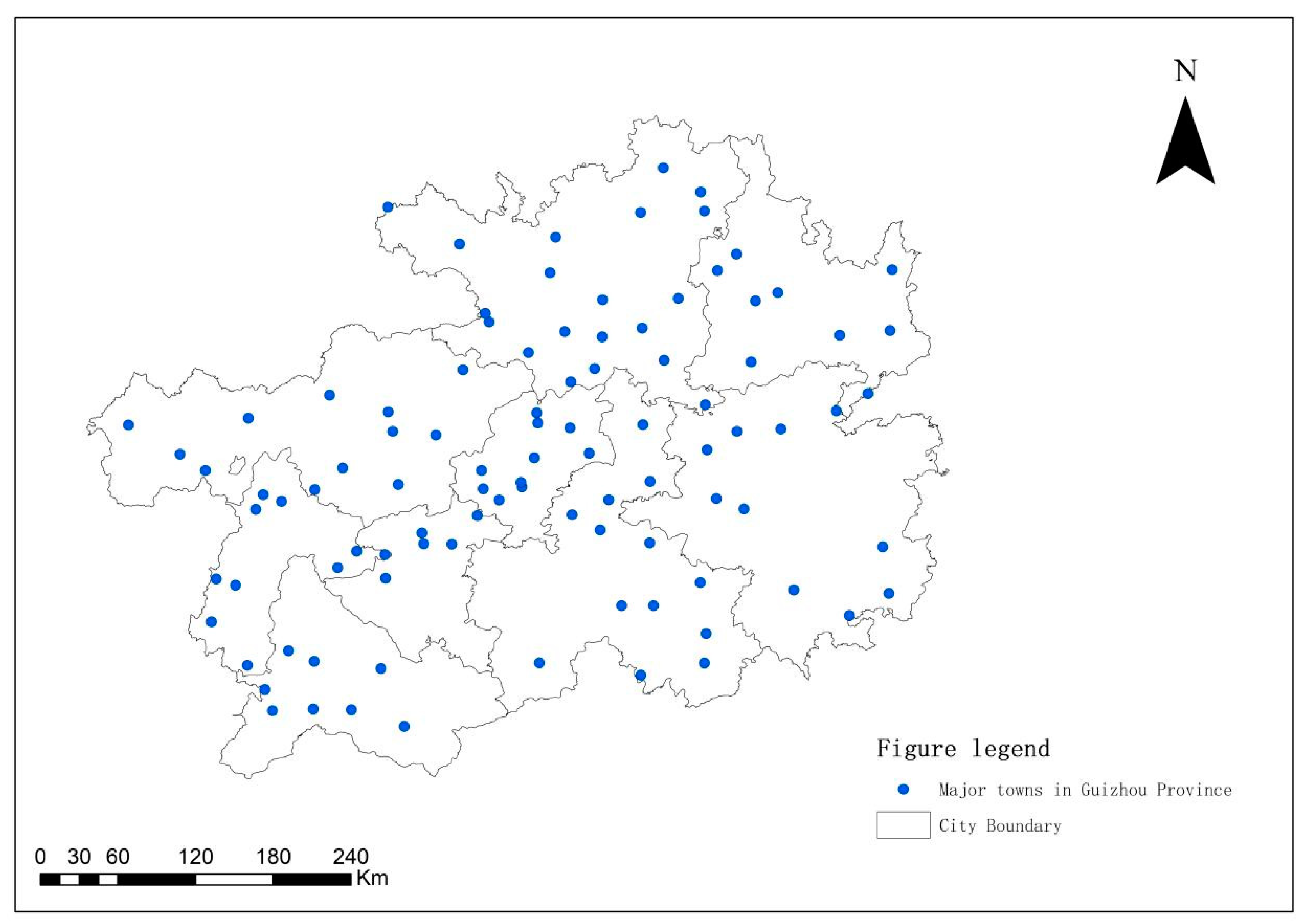
To visualize the distribution of major towns in Guizhou Province, the study selected 97 major towns as samples, obtained the specific latitude and longitude coordinate through Baidu API, transformed the coordinates of the relevant towns into point data via ArcGIS10.8 software, and superimposed them on the map of Guizhou Province to create a visual distribution map (Figure 2). Macroscopically, the number of cities and towns are not uniformly distributed among each state and city, but they are clustered in specific regions, forming an urban spatial pattern whereby “one core, one group, two circles, six groups, and multiple points” constitute the primary structure. Guiyang central city cluster serves as the core of Guizhou Province, powered by two metropolitan areas in the central region—Guiyang-Ansun and Zunyi—that radiate Liupanshui, Bijie, Tongren, Kaili, Duyun, and Xinyi, among other regional central and essential node cities. All these cities together form six town clusters in the east and west wings, as well as other characteristic town belts.

3.2. Categories of Major Towns

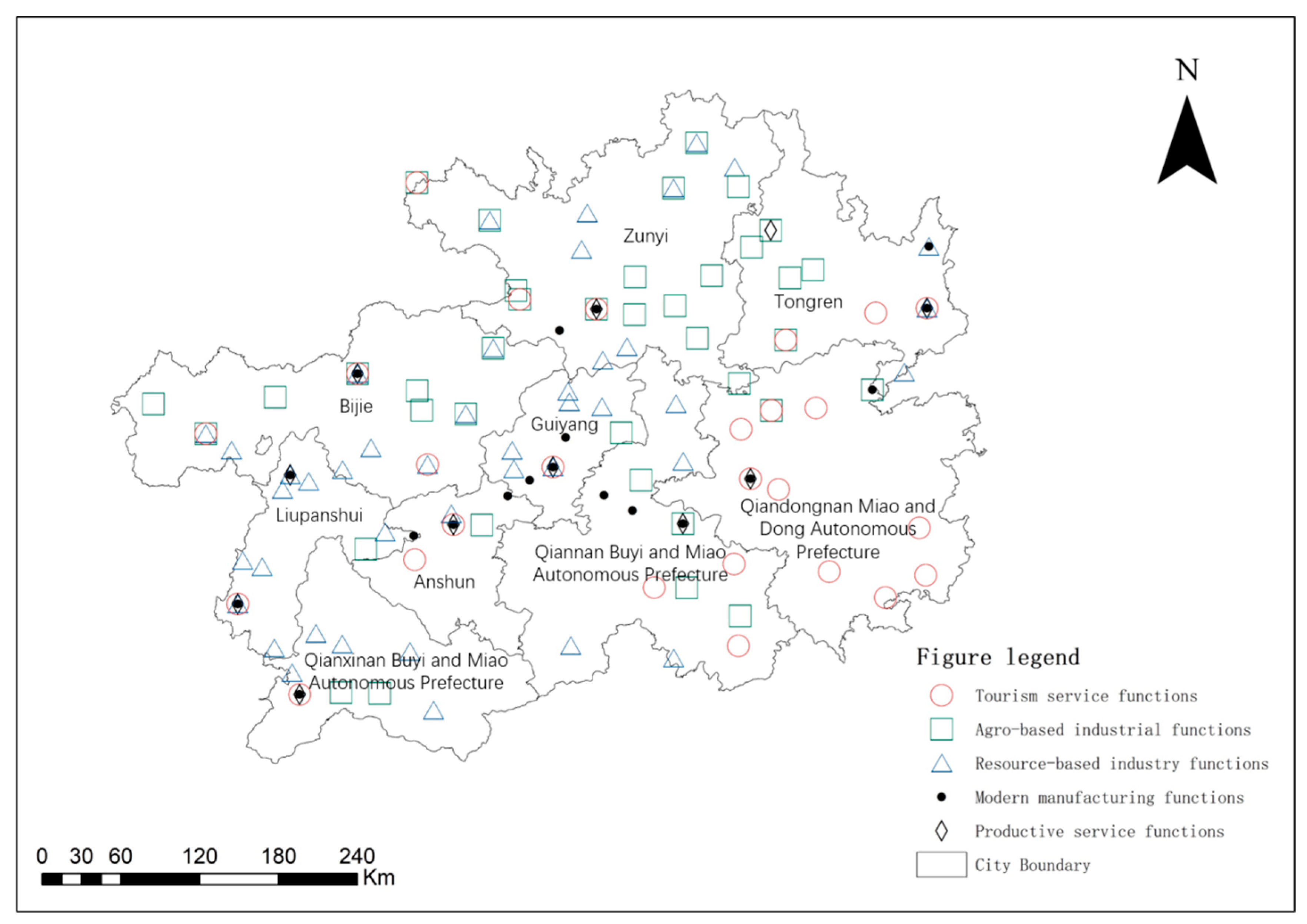
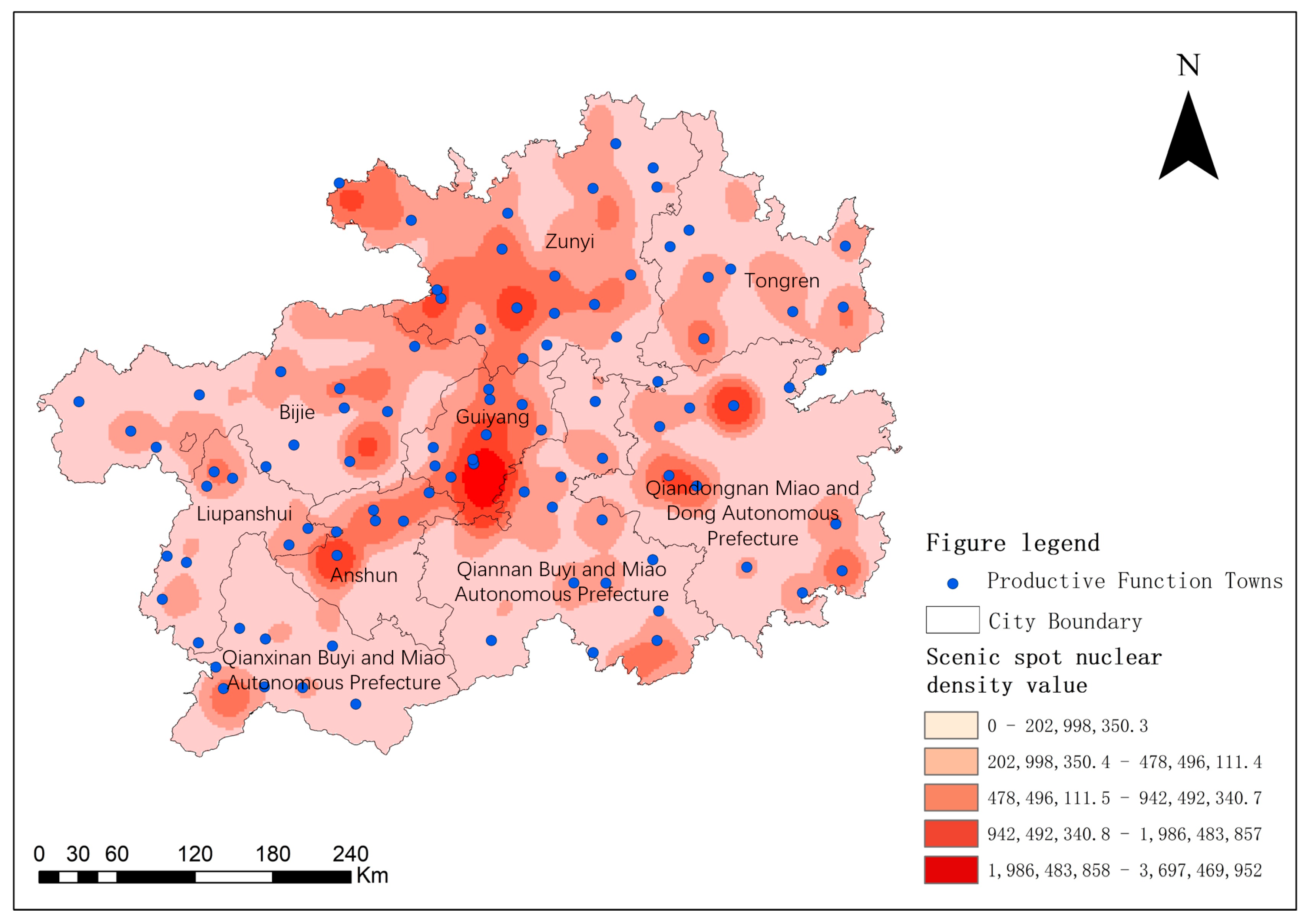
To tackle the significant differences in economic development and the diversification of urban development tasks in various regions of Guizhou Province, the spatial distribution of major towns (Figure 3) has been recognized as a pivotal factor in guiding economic and industrial growth in the area. Regarding the major towns in Guizhou Province, classification by function delineates five categories: production service towns, modern manufacturing function towns, resource-based industrial function towns, agricultural specialty industry function towns, and tourism service function towns. Production service towns are towns in which important functions, such as financial business, trade and logistics, scientific and technological research and development, and information services, contribute significantly to production organization while simultaneously exerting a dynamic effect on the regional economy. The term modern manufacturing functional town refers to the prioritization of constructing the province’s modern industrial system, especially in electronics, automobiles, new energy, new materials, new building materials, and other related areas of regional agglomeration. Resource-based industry functional towns pertain to the processing of energy and mineral resources along with the concentration of related industries derived from that concentration. The agricultural specialty industry functional town is aimed at the collection of specialty agricultural products for deep processing and the corresponding trade circulation activities, among other related areas. Lastly, tourism service functional towns are conducive to tourism organization and information consultation, catering, accommodation, and related service areas.

3.3. Concentration of Spatial Distribution

To ascertain the concentration of major towns’ spatial distribution in Guizhou province, this study borrows from Zhao Liming’s proposed geographic concentration index method [41] as follows:
Z = 100 % * i = 1 m ( X i T ) 2
The geographic concentration index ( Z ) is defined as X i , the number of major towns distributed in city i , divided by T , the total number of major towns in Guizhou province, and expressed as a ratio of m , the total number of cities and towns in Guizhou province. If the resulting geographic concentration index surpasses the geographic concentration index computed when major towns are distributed among the different states and cities in Guizhou Province on average, it suggests that major towns in Guizhou Province are concentrated. Conversely, if the result is lower, then they are dispersed. According to Formula (1), the geographic concentration index obtained when major towns are distributed in each state and city of Guizhou Province on average is 33.33%, whereas the actual geographic concentration index of major towns in Guizhou Province is 35.46%. Hence, it can be concluded that major towns in Guizhou province are indeed concentrated since their actual geographic concentration index excels the geographic concentration index computed when they are distributed in each state and city on average.

3.4. Spatial Distribution Density

The kernel density analysis method is employed to assess the spatial distribution density of point elements, enabling the research objects’ spatial distribution and clustering traits to be visually portrayed [42,43]. As the kernel density value rises, the point density also augments, and the probability of occurrence of events in the area increases. Using the kernel density method to visually depict the spatially dispersed and clustering characteristics of major towns in Guizhou province adequately compensates for the limitations of relying solely on mathematical analysis to describe the degree of geographical elements’ spatial concentration [43,44,45]. The kernel density formula is used in this method:
n ( x ) = 1 n h i = 1 n k x x i h
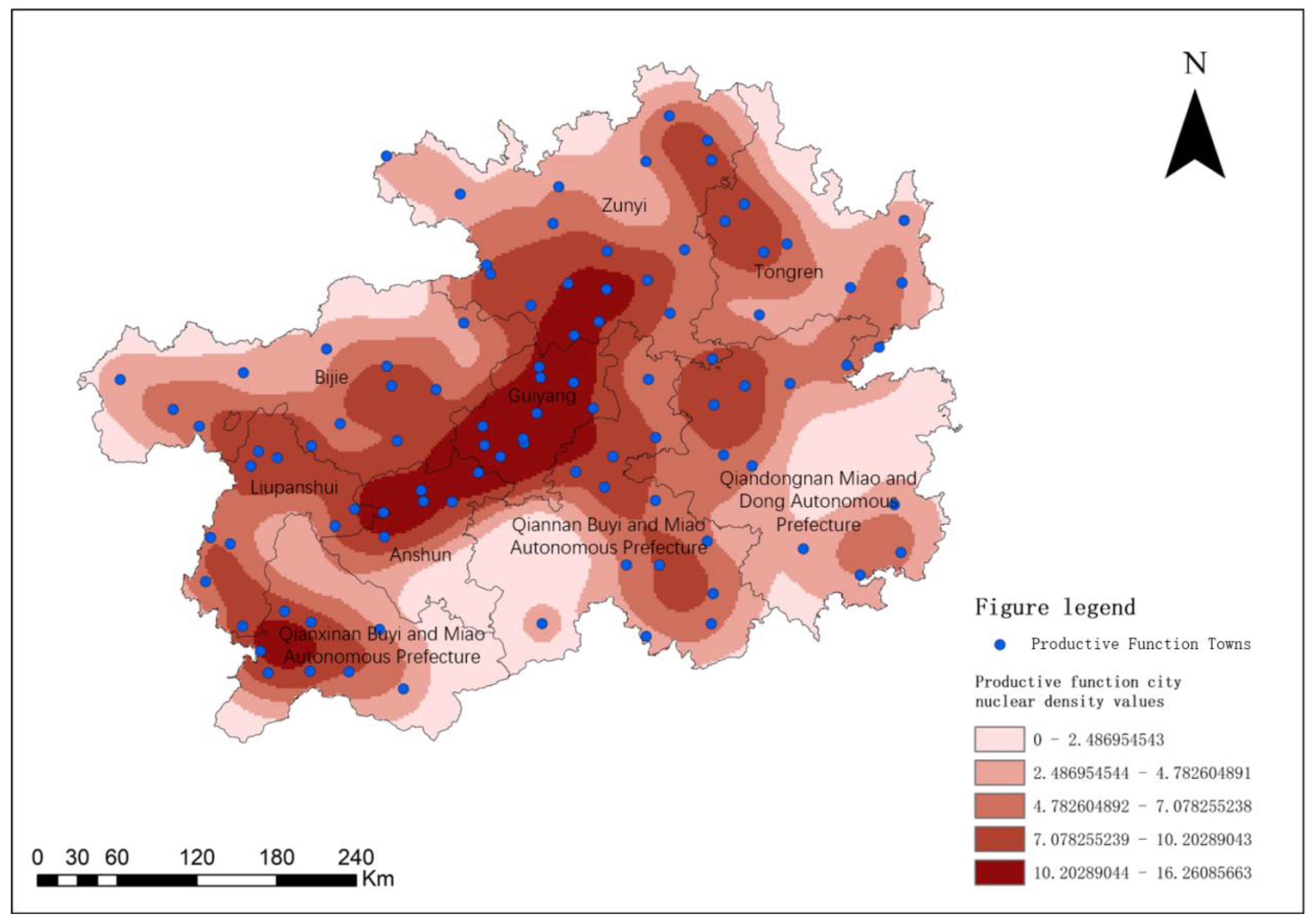
Here, k(x) represents the search radius, which influences the kernel density estimate, while xxi denotes the distance from the valuation point x to event xi. Additionally, h > 0 is the bandwidth. The Kernel Density tool of ArcGIS10.8 software is employed to produce a carefully crafted kernel density map of major towns in Guizhou Province, using different weights and applying smoothing after multiple experiments to enhance the precision of visualization. Consequently, the analysis indicates that major towns in Guizhou province exhibit conspicuous clustering characteristics (see Figure 4). Productive, functional towns are greatly concentrated in the northeast-southwest belt area surrounding “Guiyang-Anshun” and the central regions of Xinyi-Panxian in western Qianyinan and southern Liupanshui. Furthermore, secondary core areas are located in northwestern Qiandongnan, eastern Qianyinan, northwestern Tongren, eastern Zunyi, and northern Liupanshui.

3.5. Type of Spatial Distribution

The nearest neighbor index is a geographical index that characterizes the spatial proximity of point-like elements, enabling the clustering pattern of studied elements to be accurately determined [46]. The spatial distribution of major towns in Guizhou is point-like, and by computing the nearest neighbor index R, one can express the spatial proximity of major towns and assess their spatial distribution types [47,48]. The formula for calculating this index is as follows.
R = r ¯ 1 r ¯ E = 2 D
r ¯ E = 1 2 n / A = 1 2 D
where R represents the nearest proximity distance; r 1 stands for the average nearest neighbor distance; r E denotes the theoretical nearest neighbor distance; n corresponds to the number of major towns; A symbolizes the area of Guizhou province; and D signifies the density of major towns. When R equals 1, points exhibit a random spatial distribution pattern, while cohesive distribution is observed when R is less than 1. Conversely, uniform distribution tendencies are observed when R exceeds 1. By using the mean nearest neighbor tool of ArcGIS10.8 software to measure, we obtained r 1 = 0.24, r 1 = 0.22, and R = 1.10, indicating discrete patterns of major towns in macro space upon analyzing R > 1. Therefore, combined with the aforementioned assessment, it becomes apparent that major towns in Guizhou province showcase clustering patterns in specific areas and a discrete pattern at the macro level, implying that major towns take on the form of urban clusters in each state and city.

4. Analysis of the Factors Influencing the Spatial Distribution of Major Towns in Guizhou Province

The spatial distribution of cities and towns is influenced by a range of factors, including the state of the road network, natural environmental conditions, the endowment of human resources, and policy conditions. We shall further explain these factors in detail below.

4.1. Road Network

The road network serves as one of the key urban infrastructures, exerting a profound influence on the distribution and development of cities and towns. The complex terrain in Guizhou Province presents a significant challenge in constructing the road network. In recent years, with the improvement of engineering technology, the total length of transportation road network in Guizhou Province has risen by leaps and bounds and has basically formed a transportation road network.Some cities and towns have developed rapidly due to the improvement in traffic conditions, such as Zunyi City. The social and economic development of Zunyi City is second only to Guiyang City, which is inseparable from the construction of transportation. By overlaying data on transportation networks and major town points in Guizhou province, this study displays the impact of traffic factors on the spatial distribution of towns in a compelling visual manner. The analysis confirms that traffic arteries in Guizhou province cover virtually all major towns (Figure 5), while expressways and railroads portray a radial pattern emanating from Guiyang city, distributed in a pointing axis. Most major towns are intertwined with the traffic axes, with several towns being proximate to either railroads or highways, indicating the vital role that the transportation road network plays in the distribution of different genres of major towns in Guizhou Province.

4.2. Natural Environmental Conditions

4.2.1. Terrain and Topography

The terrain is a key factor in the choice of settlements and an important factor in the formation and development of towns. Different terrain and topography give birth to different natural landscapes, represent different natural resource endowments, and determine the development direction of towns to a certain extent. By overlaying point data of major towns in Guizhou Province with elevated topographic maps via ArcGIS10.8, a compelling visualization effect is achieved (see Figure 6). The analysis confirms that the eastern section of Guizhou Province is characterized by hilly and mountainous terrain, with mountain plains and plateaus largely prevailing in the central regions, and mountainous terrain dominating the western and southern parts. Main towns are predominantly distributed in mountainous areas and plateaus that boast relatively flat topography, as well as hilly and mountainous terrain. The western part of Guizhou Province has abundant mineral resources, and due to the prevalence of mountains in this area, towns with resource-based industrial functions are mainly situated in Qianxinan’s western region and the western and northern mountainous regions of Liupanshui. As the central and northern parts of Guizhou Province comprise the Yunnan–Guizhou Plateau, the terrain here is relatively flat and elevated, and hence, most towns concentrated on production service functions are located in this region. Broadly speaking, the distribution characteristics of major towns in Guizhou Province are closely linked to the region’s diverse topography. For instance, towns located in mountainous areas center on mineral resource exploitation, towns located in plain areas prioritize agriculture, processing and manufacturing, and logistics, while towns located in plateau areas are primarily associated with agricultural cultivation. This topography plays a crucial role in determining the industrial composition and development pathways of towns and cities.

4.2.2. Endowment of Tourism Resources

Guizhou, located in the eastern region of the Yunnan–Guizhou plateau, boasts a diverse and intricate topography that has nurtured a wide range of natural landscapes. The region comprises a cultural melting pot and is inhabited by an array of ethnic minorities, making it an ideal destination for tourists seeking to explore diverse natural and human landscapes in Guizhou. Over the past decade, with the continuous improvements made to Guizhou’s infrastructure, the tourism industry in Guizhou has flourished and now serves as a key force driving economic growth in the region. The renowned 4A-level scenic spots in Guizhou Province span a range of national/provincial scenic areas, national/provincial historical and cultural cities, towns, and villages that offer diverse, unique vistas. They attract an increasing number of visitors and generate substantial tourism revenue, thereby providing a clear indicator of the status of tourism resource endowment in Guizhou Province.
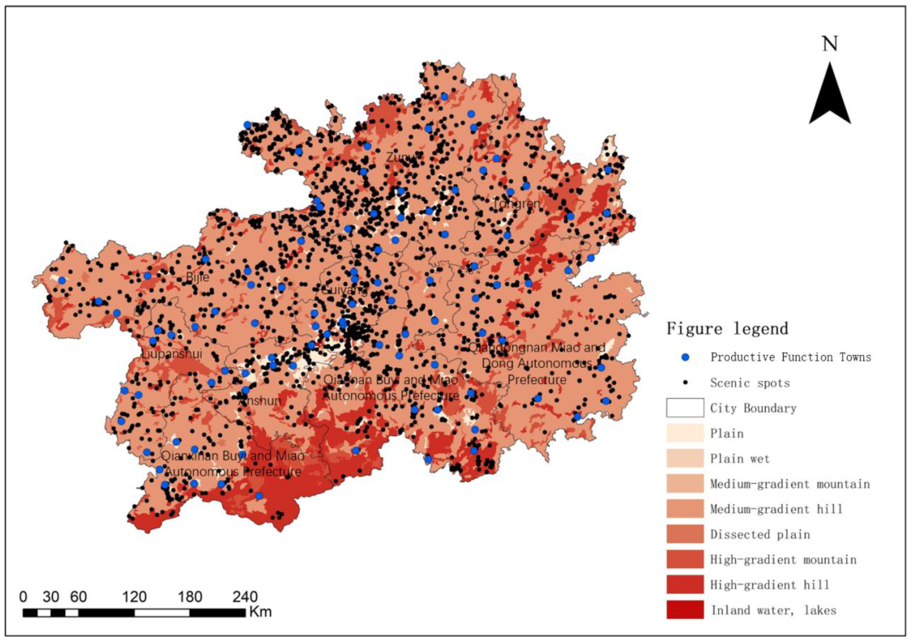
As of 2023, the Guizhou Provincial Department of Culture and Tourism list of class-A tourist attractions reports nine 5A-level and 143 4A-level tourist attractions, reflecting the abundance and superiority of Guizhou province’s tourism resources(see Figure 7). Generally speaking, the 5A-level scenic spots in Guizhou Province are mainly concentrated in the Bijie-Zhenyuan line, and 4A-level tourist attractions are evenly distributed in various prefectures and cities. It should be noted here that the development of tourism services will strengthen the agglomeration of town spaces and form urban clusters with more agglomeration effect, because Guizhou province has very rich tourism resources, and tourism is an important industry that needs to strengthen its services to enhance urbanization. Guiyang ‘s rich tourism resources have made great contributions to the urbanization of Guiyang. The development of tourism has made the urbanization level of Huaxi District of Guiyang gradually keep up with the pace of Guiyang City, and the regional development is more coordinated.

4.2.3. Endowment of Humanistic Resources

Culture is a potential resource for local development. The distribution and development of major towns in Guizhou Province are not only closely related to natural resources, but also cultural factors. As such, when laying out major towns in Guizhou Province, it is essential to consider cultural elements and combine them with development in order to generate positive momentum, foster vitality, and facilitate local economic growth. Guizhou possesses abundant human resources. As a multi-ethnic province, Guizhou is home to 18 ethnic groups, including the Miao, Dong, Shui, and Gelao ethnic groups, which boast a diverse range of cultural resources.
Apart from the vibrant ethnic culture, Guizhou’s red culture boasts profundity, with its unique resources spanning all revolutionary periods and many national patriotic education demonstration bases. Such resources constitute a distinctive asset for the new endeavor of constructing a modern socialist state. And it is also an important resource for Guizhou Province to realize new urbanization and develop characteristic towns in the new era.
Throughout Guizhou’s long history, several renowned historical and cultural cities, towns, villages, and traditional villages with exceptional regional characteristics have been established, offering high-quality cultural resources that cities and towns can employ to achieve different development objectives.

4.3. Government Policy Support

Following the 18th Party Congress, the Party Central Committee has fundamentally prioritized the work of new urbanization, putting forth the strategy of new urbanization with people at the core and quality enhancement as the guiding principle. This approach has provided a clear orientation and basic guiding principles for the work of new urbanization, enabling China’s urbanization to enter a new phase of improvement in quality and efficiency, yielding historic achievements. In 2015, the Guizhou Provincial People’s Government led the approval of the Guizhou Provincial Urban System Plan (2015–2030) by the State Council. This plan emphasizes Guizhou Province’s cohesive adherence to the strategic urbanization policy, acceleration of the Qianzhong Urban Cluster’s development, with Guiyang as its core nucleus, and the building of an “Anshan-One Guiyang” urban area, creating two urban areas, namely, “Guiyang-Anshun” and Zunyi. It involves the development of regional central cities, including Liupanshui, Bijie, Tongren, Kaili, Duyun, Xinyi, and several critical nodal cities, constructing a “one technology, one group, two circles, six groups, multi-point” spatial pattern of towns. In 2022, the provincial government was slated to devise a plan for the new urbanization development in Guizhou Province within the framework of the 14th Five-Year Plan, including the Guiyang-Guizhou urban area development plan and the Guiyang-Anshun urban area development plan. The process of urbanization in Guizhou has highlighted the approval of the Anshun metropolitan area and Zunyi metropolitan area development plan that it is necessary to adhere to the guidance of Xi Jinping’s thought of socialism with Chinese characteristics in the new era, thoroughly implement the spirit of the important speech of General Secretary Xi Jinping’s inspection of Guizhou, embracing high-quality development as an overarching concept, we must fully execute the “one, two, three, four” comprehensive notion, which seeks to streamline spatial layouts, enhance the quality of towns, strengthen their economies, and augment the level of governance. Of great importance are the expedited construction of the Guiyang-Gui’an-Anshun metropolitan area and Zunyi metropolitan area, thereby accelerating the new urbanization process and providing strategic support for constructing a vibrant Guizhou, replete with prosperous people and ecological beauty. Thus, the several national and Guizhou provincial documents relating to urbanization have a crucial role to play in furthering the layout, development, and research of major towns in Guizhou Province.

5. Conclusions and Future Work

5.1. Conclusion

Having scrutinized the major town categories in Guizhou Province, this investigation employed a range of techniques, including ArcGIS to quantitatively analyze the distributional characteristics. Furthermore, this study decomposed the factors influencing the distributional patterns and identified regional distributional differences to propose an overall distributional pattern. Consequently, the following conclusions were drawn.
(1)
The number and distribution of major cities and towns within each city and state in Guizhou Province are not substantially disparate, yet certain regions reveal agglomerative tendencies, generating an urban spatial order characterized by a “one core, one group, two circles, six groups, and multiple points”;
(2)
The geographic concentration index (z = 33.33% per state and city in Guizhou Province, and z = 35.46% for major towns in Guizhou Province) reflects that the factual geographic concentration index for major towns in Guizhou Province exceeds both the average distribution of major towns and the geographic concentration index of each state and city. As a result, it indicates that major towns within Guizhou Province are centralized and dispersed;
(3)
The road transportation system exerts a substantial influence on the distribution and evolution of diverse functional towns within Guizhou Province, and the spatial structure of towns is disseminated along a point-axis distribution, with a high degree of spatial coincidence with the transportation axis. The natural environmental conditions, human-tourism resource endowments, and their respective distributions serve as the conditions and basis for the development of major towns in Guizhou Province. Moreover, policy incentives exert a significant impact on the distribution and progression of major towns in Guizhou Province.

5.2. Future Work

This paper examines the spatial distribution and determining factors of key towns in Guizhou Province. By utilizing Arc GIS and other cutting-edge technologies, we conduct a quantitative analysis of the spatial distribution characteristics and examine the factors that influence this distribution. Additionally, we reveal the overall distribution pattern and regional disparities. The findings hold significant implications for new urbanization, coordinated urban-rural development, and rural revitalization in the region. Moreover, the research outcomes can serve as a valuable reference for future enhancements in the urban layout optimization of Guizhou Province. Moving forward, we can refine the urban data and further enrich our investigation into the evolution of spatial structure and industrial layout. To foster the development of major towns in Guizhou Province, the following measures can be implemented in the future:
(1)
The government must meticulously plan out the layout of major towns to foster the unique growth of prominent core urban clusters and prevent redundant construction;
(2)
Enhancing transportation and infrastructure, leveraging existing transportation conditions to promote the development of varied functional towns, and strengthening their linkage to neighboring cities to cultivate a driving development pattern;
(3)
Culture is the heart and soul of town development, especially within the tourism service town sector. Planning must harness the influence of culture, highlight distinctiveness, and balance historical and contemporary aspects;
(4)
Embracing the principle of integrated development of “distinctiveness”, “environmental sustainability”, and “harmonious coexistence”, fully exploiting the “distinctiveness” of diverse functional towns, and capitalizing on regional resource advantages to guarantee the sustainable and wholesome advancement of towns.

Author Contributions

Conceptualization, C.L. and Y.W.; data curation, H.P. and C.L.; funding acquisition, H.P.; methodology, C.L., H.P. and Y.W.; visualization, H.P. and Y.W.; writing—original draft, C.L. and H.P.; writing—review & editing, C.L. and Y.W. All authors have read and agreed to the published version of the manuscript.

Funding

This research was funded by Ministry of Education’s Youth Project(No. 19YJC850004); The National Natural Science Foundation of China (No. 42261035); Guizhou University’s Youth Project (No. GDQN2018013).

Institutional Review Board Statement

Not applicable.

Informed Consent Statement

Not applicable.

Data Availability Statement

The data that support the findings of this study are available from the corresponding author (Caiqing Liu) upon justifiable request.

Conflicts of Interest

The authors declare no conflict of interest.

References

  1. Webb, J.W. Basic concepts in the analysis of small urban centers of minnesota. Ann. Assoc. Am. Geogr. 1959, 49, 55–72. [Google Scholar] [CrossRef]
  2. Berry, B.J.L. City Size Distribution and Economic Development. Econ. Dev. Cult. Chang. 1961, 9, 573–588. [Google Scholar]
  3. Berry, B.J.L. Cities as systems within systems of cities. Pap. Reg. Sci. 1964, 13, 147–163. [Google Scholar] [CrossRef]
  4. Berry, B.J.L.; Okulicz-Kozaryn, A. The city size distribution debate: Resolution for US urban regions and megalopolitan areas. Cities 2012, 29, S17–S23. [Google Scholar] [CrossRef]
  5. Alperovich, G. The size distribution of cities: On the empirical validity of the rank-size rule. J. Urban Econ. 1984, 16, 232–239. [Google Scholar] [CrossRef]
  6. Svensson, M.K.; Thorsson, S.; Lindqvist, S. A geographical information system model for creating bioclimatic maps—Examples from a high, mid-latitude city. Int. J. Biometeorol. 2003, 47, 102–112. [Google Scholar] [CrossRef]
  7. Deng, C.F.; Ji, J.J. The Flexible Spatial Structure Planning of Cities under Uncertainty Development. AMM 2012, 209, 526–530. [Google Scholar] [CrossRef]
  8. Zagroba, M.; Pawlewicz, K.; Senetra, A. Analysis and Evaluation of the Spatial Structure of Cittaslow Towns on the Example of Selected Regions in Central Italy and North-Eastern Poland. Land 2021, 10, 780. [Google Scholar] [CrossRef]
  9. Gould, P. Review of Locational Analysis in Human Geography. Geogr. Rev. 1967, 57, 292–294. [Google Scholar] [CrossRef]
  10. Kusnierz-Krupa, D. Issue of Protecting Historic Urban Layouts of Small Towns in South-Eastern Poland—On Selected Examples. IOP Conf. Ser. Mater. Sci. Eng. 2019, 471, 082034. [Google Scholar] [CrossRef]
  11. Thilagam, N.L.; Banerjee, U.K. The morphological characteristics of medieval temple towns of Tamilnadu. Environ. Plan. B Plan. Des. 2016, 43, 7–33. [Google Scholar] [CrossRef]
  12. Musiaka, Ł.; Sudra, P.; Spórna, T. Spatial Chaos as a Result of War Damage and Post-War Transformations. Example of the Small Town of Węgorzewo. Land 2021, 10, 541. [Google Scholar] [CrossRef]
  13. Baumanova, M.; Smejda, L.; Rüther, H. Pre-Colonial Origins of Urban Spaces in the West African Sahel: Street Networks, Trade, and Spatial Plurality. J. Urban Hist. 2019, 45, 500–516. [Google Scholar] [CrossRef]
  14. Nie, R.; Zeng, J.; Zhao, X.P. Spatial Design Research for Urban Mitigation to Strength Urban Resilience. Adv. Mater. Res. 2011, 368, 3388–3391. [Google Scholar] [CrossRef]
  15. Xu, Y.; Rollo, J.; Jones, D.S.; Esteban, Y.; Tong, H.; Mu, Q. Towards Sustainable Heritage Tourism: A Space Syntax-Based Analysis Method to Improve Tourists’ Spatial Cognition in Chinese Historic Districts. Buildings 2020, 10, 29. [Google Scholar] [CrossRef] [Green Version]
  16. Lin, C.; Cheng, H. Renaissance of the Old Town District in Tainan: Research on Aesthetic Zoning in Historic Districts. J. Asian Archit. Build. Eng. 2008, 7, 317–324. [Google Scholar] [CrossRef]
  17. Niu, S.; Hu, A.; Shen, Z.; Lau, S.S.Y.; Gan, X. Study on land use characteristics of rail transit TOD sites in new towns—Taking Singapore as an example. J. Asian Archit. Build. Eng. 2019, 18, 16–27. [Google Scholar] [CrossRef] [Green Version]
  18. Zagroba, M.; Pawlowicz, J. Selected Aspects of Revitalisation in the Land Development of the City Moat in Jeziorany. IOP Conf. Ser. Mater. Sci. Eng. 2019, 603, 052073. [Google Scholar] [CrossRef]
  19. Hwang, R.-L.; Lin, C.-Y.; Huang, K.-T. Spatial and temporal analysis of urban heat island and global warming on residential thermal comfort and cooling energy in Taiwan. Energy Build. 2017, 152, 804–812. [Google Scholar] [CrossRef]
  20. Wang, F.; Liu, X.; Jiang, B.; Zhuo, H.; Chen, W.; Chen, Y.; Li, X. Low-loading Pt nanoparticles combined with the atomically dispersed FeN4 sites supported by FeSA-N-C for improved activity and stability towards oxygen reduction reaction/hydrogen evolution reaction in acid and alkaline media. J. Colloid Interface Sci. 2023, 635, 514–523. [Google Scholar] [CrossRef]
  21. Li, Q.; Zhao, D.; Yin, J.; Zhou, X.; Li, Y.; Chi, P.; Han, Y.; Ansari, U.; Cheng, Y. Sediment Instability Caused by Gas Production from Hydrate-bearing Sediment in Northern South China Sea by Horizontal Wellbore: Evolution and Mechanism. Nat. Resour. Res. 2023, 32, 1595–1620. [Google Scholar] [CrossRef]
  22. Li, Q.; Zhang, C.; Yang, Y.; Ansari, U.; Han, Y.; Li, X.; Cheng, Y. Preliminary experimental investigation on long-term fracture conductivity for evaluating the feasibility and efficiency of fracturing operation in offshore hydrate-bearing sediments. Ocean Eng. 2023, 281, 114949. [Google Scholar] [CrossRef]
  23. Kwak, Y.; Park, C.; Deal, B. Discerning the Success of Sustainable Planning: A Comparative Analysis of Urban Heat Island Dynamics in Korean New Towns. Sustain. Cities Soc. 2020, 61, 102341. [Google Scholar] [CrossRef]
  24. Wang, L. China’s new town movements since 1949: A state/space perspective. Prog. Plan. 2020, 155, 100514. [Google Scholar] [CrossRef]
  25. Zou, Y. Capital switching, spatial fix, and the paradigm shifts of China’s urbanization. Urban Geogr. 2021, 43, 1662–1682. [Google Scholar] [CrossRef]
  26. Chen, Y.; Bing, H.; Zhang, L.G. The Marshlands Degradation and the Urban Spatial Transformation: A Case Study of “Town” and “Market” in Jingzhou City. Adv. Mater. Res. 2012, 599, 943–949. [Google Scholar] [CrossRef]
  27. Gu, X.; Tao, S.; Dai, B. Spatial Accessibility of Country Parks in Shanghai, China. Urban For. Urban Green. 2017, 27, 373–382. [Google Scholar] [CrossRef]
  28. Jing, C. Quantitative Evaluation of Spatial Differentiation for Public Open Spaces in Urban Built-Up Areas by Assessing SDG 11.7: A Case of Deqing County. ISPRS Int. J. Geo-Inf. 2020, 9, 575. [Google Scholar]
  29. Geng, H.; Qiao, J. Assessment of Small Towns’ Fitness around China’s Major Cities: A Case Study in Wuhan City. Sustainability 2018, 10, 2154. [Google Scholar] [CrossRef] [Green Version]
  30. Dai, J.; Fan, B.; Wang, J.; Wang, Y. Interference of Urban Spatial Evolution to Wetland Ecosystem; Spin-Int Soc Optical Engineering: Cairo, Egypt, 2011; p. 82852F. [Google Scholar]
  31. Li, J.; Chiu, R.L.H. State rescaling and large-scale urban development projects in China: The case of Lingang New Town, Shanghai. Urban Stud. 2020, 57, 2564–2581. [Google Scholar] [CrossRef]
  32. Wei, K. Analyzing Hierarchy Spatial Structure of Chinese Ancient Town. In Proceedings of the International Conference on Civil Engineering, Architecture and Building Materials, Kunming, China, 26–28 July 2011. [Google Scholar]
  33. Tao, H.; Huang, Z.; Ran, F. Rural Tourism Spatial Reconstruction Model from the Perspective of ATV: A Case Study of Mufu Township, Hubei Province, China. Sustainability 2018, 10, 2675. [Google Scholar] [CrossRef] [Green Version]
  34. Zhou, H.; Li, B.H.; Xiao, Q. A Study on Spatial Forms Characteristic of the Historic Towns in Yuan River Basin. Appl. Mech. Mater. 2011, 71, 3639–3642. [Google Scholar] [CrossRef]
  35. Wang, L.; Yao, P. Analysis of the Landscape Space Evolution Characteristics in Sichuan Qijiang Historical Town. In Proceedings of the International Conference on Civil Engineering, Architecture and Building Materials, Yantai, China, 25–27 May 2012. [Google Scholar]
  36. Ding, A.; Cenci, J.; Zhang, J. Links between the pandemic and urban green spaces, a perspective on spatial indices of landscape garden cities in China. Sustain. Cities Soc. 2022, 85, 104046. [Google Scholar] [CrossRef] [PubMed]
  37. Zhan, Z.; Cenci, J.; Zhang, J. Frontier of Rural Revitalization in China: A Spatial Analysis of National Rural Tourist Towns. Land 2022, 11, 812. [Google Scholar] [CrossRef]
  38. Xie, Y.; Meng, X.; Cenci, J.; Zhang, J. Spatial Pattern and Formation Mechanism of Rural Tourism Resources in China: Evidence from 1470 National Leisure Villages. IJGI 2022, 11, 455. [Google Scholar] [CrossRef]
  39. Yang, C.; Huang, J.; Lin, Z.; Zhang, D.; Zhu, Y.; Xu, X.; Chen, M. Evaluating the symbiosis status of tourist towns: The case of Guizhou Province, China. Ann. Tour. Res. 2018, 72, 109–125. [Google Scholar] [CrossRef]
  40. Gao, S.; Yang, L.; Jiao, H. Changes in and Patterns of the Tradeoffs and Synergies of Production-Living-Ecological Space: A Case Study of Longli County, Guizhou Province, China. Sustainability 2022, 14, 8910. [Google Scholar] [CrossRef]
  41. Li-Ming, Z.; Hong-Bo, C. On Tourism Destination Concentration Based on Space Lorenz Curve—Taking Korean Tourists as an Example. J. Xiangtan Univ. (Philos. Soc. Sci.) 2009, 33, 147–151. [Google Scholar]
  42. Yang, R.; Xu, Q.; Long, H. Spatial distribution characteristics and optimized reconstruction analysis of China’s rural settlements during the process of rapid urbanization. J. Rural Stud. 2016, 47, 413–424. [Google Scholar] [CrossRef]
  43. Wang, X.; Xi, J.; Yang, D.; Chen, T. Spatial Differentiation of Rural Touristization and Its Determinants in China: A Geo-Detector-Based Case Study of Yesanpo Scenic Area. J. Resour. Ecol. 2016, 7, 464–471. [Google Scholar]
  44. Shen, J.; Zhang, N.; Gexigeduren; He, B.; Liu, C.-Y.; Li, Y.; Zhang, H.-Y.; Chen, X.-Y.; Lin, H. Construction of a GeogDetector-based model system to indicate the potential occurrence of grasshoppers in Inner Mongolia steppe habitats. Bull. Entomol. Res. 2015, 105, 335–346. [Google Scholar] [CrossRef] [Green Version]
  45. Zhang, N.; Jing, Y.-C.; Liu, C.-Y.; Li, Y.; Shen, J. A cellular automaton model for grasshopper population dynamics in Inner Mongolia steppe habitats. Ecol. Model. 2016, 329, 5–17. [Google Scholar] [CrossRef]
  46. Johnson, S.C. Hierarchical clustering schemes. Psychometrika 1967, 32, 241–254. [Google Scholar] [CrossRef] [PubMed]
  47. King, L.J. Statistical Analysis in Geography; Prentice-Hall: Hoboken, NJ, USA, 1969. [Google Scholar]
  48. Clark, P.J.; Evans, F.C. Distance to Nearest Neighbor as a Measure of Spatial Relationships in Populations. Ecology 1954, 35, 445–453. [Google Scholar] [CrossRef]
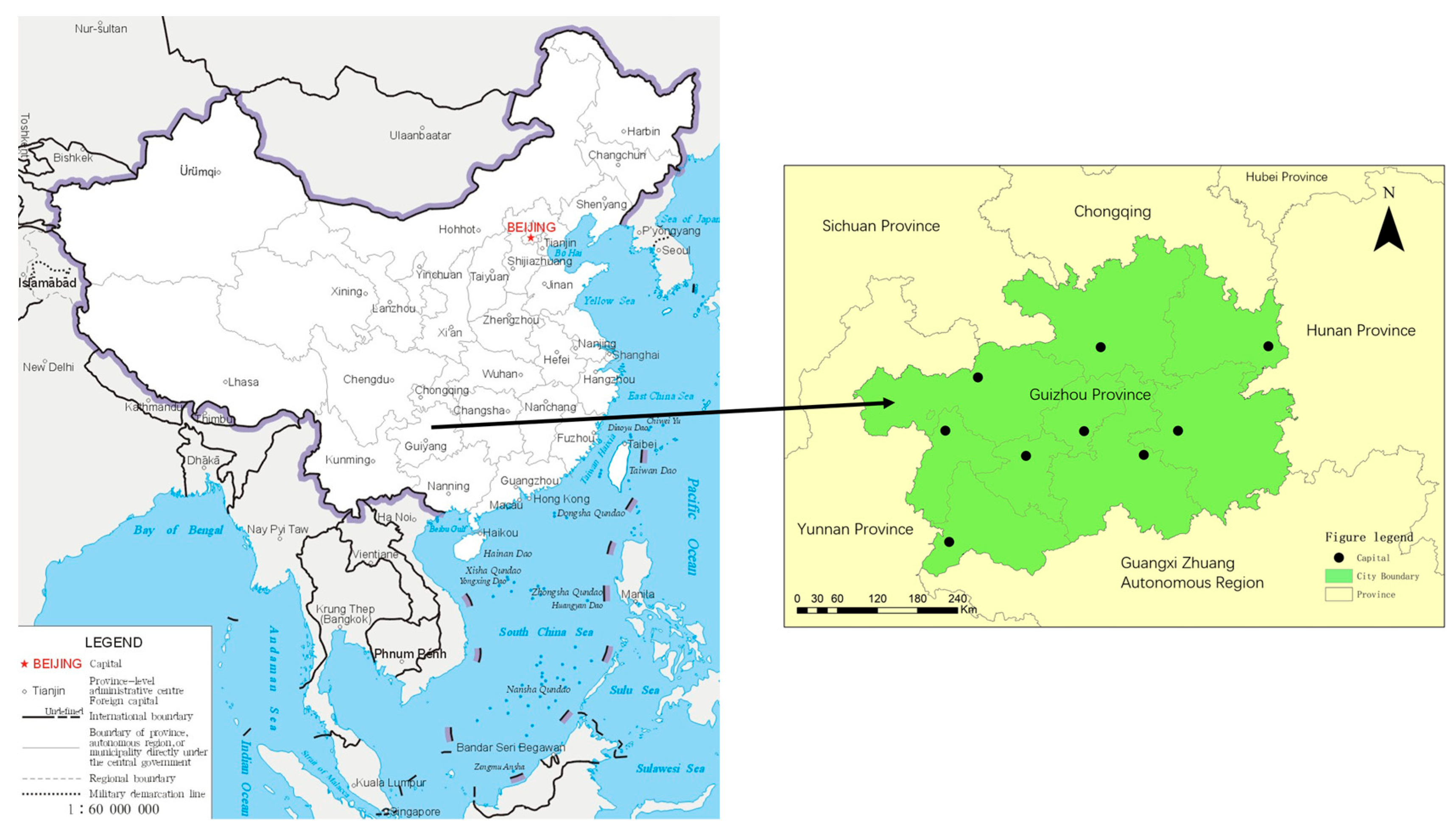
Figure 1. Location map of Guizhou Province.
Sustainability 15 10764 g001
Figure 2. Major towns distribution in Guizhou Province.
Sustainability 15 10764 g002
Figure 3. Diverse distribution of major town types.
Sustainability 15 10764 g003
Figure 4. Displays the nuclear density map of major towns in Guizhou Province.
Sustainability 15 10764 g004
Figure 5. Overlay of major towns and transportation routes in Guizhou Province.
Sustainability 15 10764 g005
Figure 6. Overlay map of major towns and topography in Guizhou Province.
Sustainability 15 10764 g006
Figure 7. Overlay Map of Towns and Scenic Spots of Tourism Service Functions in Guizhou Province.
Sustainability 15 10764 g007
Disclaimer/Publisher’s Note: The statements, opinions and data contained in all publications are solely those of the individual author(s) and contributor(s) and not of MDPI and/or the editor(s). MDPI and/or the editor(s) disclaim responsibility for any injury to people or property resulting from any ideas, methods, instructions or products referred to in the content.