Article

Quantification of Agricultural Terrace Degradation in the Loess Plateau Using UAV-Based Digital Elevation Model and Imagery

1
School of Urban Construction, Changzhou University, Changzhou 213164, China
2
Pearl River Water Resources Research Institute, Pearl River Water Resources Commission, Guangzhou 510610, China
3
School of Environment Science, Nanjing Xiaozhuang University, Nanjing 211171, China
*
Author to whom correspondence should be addressed.
Sustainability 2023, 15(14), 10800; https://doi.org/10.3390/su151410800
Submission received: 9 June 2023 / Revised: 4 July 2023 / Accepted: 6 July 2023 / Published: 10 July 2023

Abstract

:
Agricultural terraces are important artificial landforms on the Loess Plateau of China and have many ecosystem services (e.g., agricultural production, soil and water conservation). Due to the loss of rural labor, a large number of agricultural terraces have been abandoned and then the degradation of terraces, caused by rainstorm and lack of management, threatens the sustainability of ecological services on terraces. Our previous study has found its geomorphological evidence (sinkhole and collapse). However, no quantitative indicators of terrace degradation are identified from the perspective of microtopography change. A framework for quantifying terrace degradation was established in this study based on unmanned aerial vehicle photogrammetry and digital topographic analysis. The Pujiawa terraces in the Loess Plateau were selected as study areas. Firstly, the terrace ridges were extracted by a Canny edge detector based on high-resolution digital elevation model (DEM) data. The adaptive method was used to calculate the low and high thresholds automatically. This method ensures the low complexity and high-edge continuity and accuracy of the Canny edge detector, which is superior to the manual setting and maximum inter-class variance (Otsu) method. Secondly, the DEMs of the terrace slope before degradation were rebuilt through the terrain analysis method based on the extracted terrace ridges and current DEM data. Finally, the degradation of terraces was quantified by the index series in the line, surface and volume aspects, which are the damage degrees of the terrace ridges, terrace surface and whole terrace. The damage degrees of the terrace ridges were calculated according to the extracted and generalised terrace ridges. The damage degrees of the terrace surface and whole terrace were calculated based on the differences of DEMs before and after degradation. The proposed indices and quantitative methods for evaluating agricultural terrace degradation reflect the erosion status of the terraces in topography. This work provides data and references for loess terrace landscape protection and its sustainable management.

1. Introduction

Terracing increases the arable land in mountainous areas [1,2,3]. It can conserve soil and water by reducing hydrological connectivity [4,5], lengthening rainfall concentration time and controlling the overland flow velocity [6]. Terracing can also enhance soil fertility and quality and improve crop yield [1,7,8,9,10,11,12]. In addition, terraces are cultural and historical heritages in certain areas (e.g., China, Italy and Peru) [3,13,14,15], providing aesthetic landscapes and recreational options [10]. Therefore, terrace protection is of great significance for the sustainable development of agriculture, ecological security, and historical and cultural protection in mountainous areas.
Over the past few decades, the widespread abandonment of terraces has increased in many regions worldwide, such as Mediterranean countries, the Loess Plateau of China and the mountainous areas in Europe, because of the changes in social and economic perspective, national policy, migration to urban areas, increasing costs of labour and loss of productivity [2,3,6,16,17,18,19]. Many studies reported that abandoned terraces are degraded because of adverse climate [20], inadequate design and construction [2,8,21,22,23] and lack of maintenance [24,25,26]. This phenomenon is manifested by the changes in the topography of the terrace area and the destruction of terraced ridges and surfaces. The lack of cultivation and sparse vegetation cover increases surface runoff and the risks of gully and landslide development [17,27], which subsequently enhances the connectivity of natural flow pathways over the abandoned terraces [20,26]. The walls of terraces had been gradually destroyed over time after they were abandoned, eventually damaging the surface structure of the terraces [27]. Monitoring and evaluating the degradation status of terraced fields are thereby important for slope disaster prevention [28]. Moreover, some studies focus on the relationship between the degradation process of terraces and the abandonment time [26,29]. The terraces abandoned for a short time experienced severe soil erosion because of the absence of maintenance and unrestored vegetation cover. The erosion rates of terraces abandoned for less than 25–30 years are approximately two to three times higher than those abandoned for more than 25–30 years [26]. The vegetation recolonisation in abandoned terraces took 20 to 60 years, and the soil erosion on terraces abandoned for approximately 20 years decreased with vegetation restoration [29]. In addition to the time of being abandoned, the slope gradient affects the degree of soil erosion in abandoned terraces [30]. These studies showed that the degradation process of terraced fields is related to many factors, including abandonment time, slope and vegetation cover. Therefore, quantifying the degradation is useful for accurately recording the process of terrace degradation, which is necessary for exploring the topography evolution laws and mechanisms of the degraded terrace slope.
Terrace degradation means the change of micro-topography at slope scale, exploring the changes in microtopography, thereby requiring high-resolution data. Unmanned aerial vehicle (UAV) photogrammetry provides a high-precision digital elevation model (DEM), and images for monitoring, mapping and exploring various surface landscapes and processes [31,32]. Many studies investigated the distribution of terrace degradation through surveys and UAV monitoring [33,34]. The UAV-based DEM has been successfully used to simulate the hydrological process on abandoned terraces slopes for detecting the occurrence of terraces damage [35]. Soil erosion on the degraded terraces can be calculated using the DEMs at different periods [17]. A method for automatically extracting damaged terraces using UAV data has been proposed [36]. However, no indicators and methods are available for quantifying the degradation of terraces.
The Loess Plateau of China is the most developed region of loess in the world in terms of extent and thickness [37]. It is also one of the most severe soil-eroded areas on Earth because its surface soils are soft and loose [38]. Agricultural terraces have a long history on the plateau [39]. In the late 1990s, the grain for green (GFG) programme converting cultivated land into grassland or forest land for soil and water conservation was implemented to restore the steep slopes [40,41]. With the development of social economy and urbanisation, a considerable rural labour force has flown to cities [42,43]. Under the urbanisation and the GFG programme, many terraces have been abandoned. The loess terrace degradation has been confirmed, and collapse and sink are important geomorphologic features during loess terrace degradation [36]. However, research on loess’ terraces mainly focused on the mapping of the spatial distribution of terraces [44,45,46,47,48,49] and the effects of soil and water conservation [50,51,52,53,54,55,56]. The degradation of loess’ terraces needs further quantitative research. Quantifying the damage degree of terraces from the perspective of geomorphology can lay a foundation for revealing the laws and mechanisms of terrain evolution during terrace degradation.
Inspired by the above considerations, this study focuses on assessing the degradation of loess’ terraces. This study aims to propose a framework for quantifying the degradation of terraces from the perspective of topography with the help of UAV-based DEMs and images. The quantitative indicators of terrace degradation are established from three aspects, namely: terrace ridge, terrace surface and terrace volume. The quantitative process and method are proposed based on digital terrain analysis.

2. Materials and Methods

2.1. Study Area

The research was conducted with three sample areas in Pujiawa (110°21′21′ E–110°21′32′ E, 37°34′18′ N–36°34′32′ N), which is situated in the Jiuyuangou watershed, Suide County, Shaanxi Province, China (Figure 1). Jiuyuangou watershed is in the hilly and gully region of the Loess Plateau in northern Shaanxi. In 1952, Jiuyuangou was designated as a location for soil and water conservation experiments, observation and demonstration basins. Afterwards, many terraces on the slopes of Liang and Mao were built. The area’s climate is semi-humid, with an annual average temperature of 8 °C, and the annual average precipitation is 475.1 mm [57]. Most of the precipitation occurs from July to September with the highest precipitation in July. The soil type of the area is loose loess soil with good permeability and high erosion.
The degradation process and characteristics of terraces are related to abandonment time, slope, and vegetation cover [26,29,30]. In order to apply the proposed method to different degradation situations, the sample areas require different conditions. Three experimental sample areas S1, S2, and S3 are selected, as shown in Figure 1d,f,h, respectively. The slope in different directions of the S1 area is roughly the same, less than 30°. Some plots were abandoned for half a year to two; some plots were planted without management and others had old apple trees left. The average slope of S2 is greater than 35 degrees, steeper than S1. The slope gradient is inconsistent. The upper slope of S2 is gentle, and the slope of east and west slopes is steep. The vegetation coverage of S2 is similar to that of S1. The S3 area was abandoned for about 20 years in response to the GFG policy. At first, alfalfa was planted as a vegetation for conversion to farmland, and then the area was in natural recovery without maintenance. Terraces in S3 can be divided into two types, which are narrow terraces with low ridges built by manpower in the northeast and middle and wide terraces with high ridges in the rest. Table 1 lists the basic topographic information and terrace parameters of the three study areas.

2.2. Data Acquisition

High-resolution DEMs and imagery were used to quantify the degradation of terraces. These data were obtained through UAV photogrammetry in August 2020. Firstly, a DIJ Phantom 4 RTK drone was used to take optical aerial photographs of the sample areas. A total of 320 images of the sample areas were obtained with a flight overlapping rate larger than 70% and a side overlapping rate larger than 50%. The horizontal and vertical accuracies were controlled by the checkpoints measured through GPS equipment. The numbers of the checkpoints of the S1, S2 and S3 area were 8, 12 and 8, respectively. Secondly, the data of the sample areas were generated via Pixel4D Mapper software. Three-dimensional key points were obtained by aerial triangulation and then matched with overlapping images. The dense point cloud was generated by a 3D triangulation network. The images and DSMs (Digital surface models), with 0.03 m resolution of the sample areas, were rasterised from point clouds. Finally, vegetation points were removed through some proposed filtering algorithms in Cloud Compare software [58], and the DEMs with 0.2 m resolution were generated.

2.3. Evaluation of Terrace Degradation

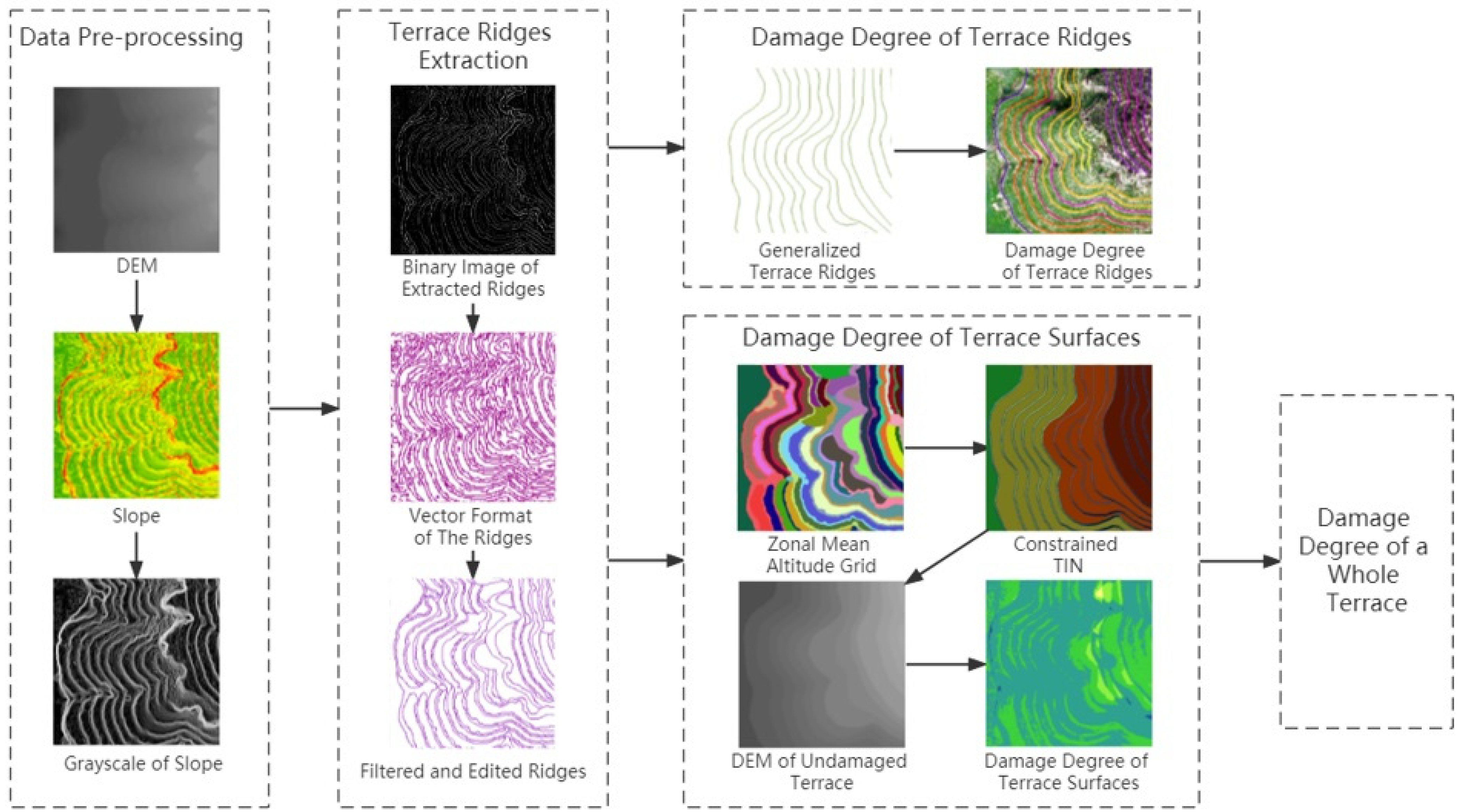
This study quantified and evaluated the degree of terrace degradation from terrace ridge, terrace surface and terrace volume. It then proposed three indicators, that are, damage degree of terrace ridges, damage degree of terrace surface and damage degree of a whole terrace. The ridge line is an important topographic feature line of terrace, which is also the key to quantify the degradation of terrace. For this reason, the experimental process started from the data preprocessing for extraction of the ridge line. The key data are the grayscale of slope, which is generated from the DEM of degraded terrace. Secondly, the extraction experiment of ridge line was carried out by Canny algorithm with adaptive thresholds. The extraction method is detailed in Section 2.3.1. Then, based on the extraction of the ridge line, the damage degree of the terrace ridge line was calculated. The calculation method is presented in Section 2.3.3. Finally, the damage degree of the terrace surface and the whole terrace were calculated, as shown in Section 2.3.3. This calculation required DEM before and after the degradation of terraces. The later DEMs were obtained by UAV photogrammetry. The DEM of undamaged terraces before degradation was constructed based on TINs generated by the ridge lines, which were generalised through the extracted ridge lines in the second step as the constraint line, with the specific process shown in Section 2.3.2. Figure 2 illustrates the entire workflow of this study.

2.3.1. Extraction of Terrace Ridges

Terrace ridges (i.e., top and bottom edges of terrace walls) forming the main characteristics of terraces are essential data for constructing terrace DEMs before the fields were damaged. Although the damaged terraces suffered soil erosion and collapse, most terrace ridges are still distinct. The terrace ridges can be extracted through the existing edge detection methods because they show the linear features in high-resolution images clearly [59]. However, the extracted results have a lot of noise. Dai et al. (2019) supposed a method that extracts terrace ridges from remote-sensing images by combining the edge detection method of the Canny operator and the contour direction derived from DEM. This method is suitable, however, the terrace images in that study almost have no vegetation cover, and the shape of those terraces is nearly circular. Therefore, this method cannot be directly used in the present study.
Edge detection is the basic content of feature extraction and image processing for computer visualisation. It can identify and locate sharp discontinuities of images, which are abrupt changes in pixel intensity [60,61]. Various edge detection techniques exist, such as Sobel operator, Robert’s cross operator, Prewitt’s operator, Laplacian of Gaussian and Canny algorithm. The Canny edge detector achieves the best results by defining three criteria to ensure that the detector responds only once to a single edge [61,62]. It is insensitive to noise in an image because the Gaussian filter is conducted prior to the other steps. However, the adjustable parameter σ, which is the standard deviation of the Gaussian filter and the threshold values, affects the performance of the Canny algorithm [61,62].
In the present study, the resolution of the DEM data obtained from UAV photogrammetry is so high that even tiny fluctuations of terrain are visible. Terraces have clear feature lines, however, small disturbances can affect the final extraction results. Therefore, the parameter σ should have a large value, increasing the size of the Gaussian filter. Then, the image is blurred because the noise is filtered as much as possible. The size of the Gaussian filter finally takes five, and the parameter σ can be calculated according to the size in the present study.
The Canny algorithm has two thresholds: high and low. The smaller the thresholds are, the more image details can be obtained. The thresholds are usually determined via the Otsu method or by setting a fixed ratio between the high and low thresholds. The former can obtain the high threshold to extract strong edges, and then the low threshold is set to a fixed multiple of the high threshold, which is not adaptive to various images. Moreover, the latter has no universality. Therefore, an adaptive method to obtain the thresholds is used.
The steps of extracting terrace ridges are as follows:
Step 1.
The DEMs of the study areas are filled with depressions. The slope values of the DEMs are mapped with grayscale values ranging from 0 to 255. The generated images are smoothed by a Gaussian filter with the size of 5.
Step 2.
The gradients in the x and y directions, Gradx(x, y) and Grady(x, y), are calculated by Sobel operations. Then, the image gradient Grad(x, y) and gradient direction θ are calculated.
Step 3.
Nonmaximum suppression should be applied based on the gradient direction. If the gradient value of the pixel is less than that of two adjacent pixels in the gradient direction, the value of this pixel is set to 0, indicating that this pixel is not on the edges.
Step 4.
The high and low thresholds are calculated adaptively. The calculation formula of the high threshold is as follows:
T = G p + ( i = 0 N ( G i G p ) n / N ) 1 / n
where Gp is the gradient corresponding to the peak value of histogram obtained by the statistics of the gradient in Step 3, Gi is the gradient value of pixel I, N is the total number of pixels, and n is usually 2 or 3. In this study, n equals 3. After the high threshold is calculated, the pixels higher than the high threshold are removed from the gradient graph, and the low threshold is calculated through the same method.
Step 5.
The strong and weak edges are connected. The pixels with a gradient greater than the high threshold Th form strong edges. The pixels with a gradient between the high threshold Th and the low threshold Tl form weak edges. The pixels with a gradient lower than Tl form the background. If the weak edge is connected to the strong edge, the weak edge is identified as the edge; otherwise, the weak edge is converted into the background.
The process of extracting the terrace ridges by the Canny algorithm with adaptive thresholds is realised with Python programming.

2.3.2. Reconstruction of Undamaged Terrace DEM

The DEM data was unavailable before the terraces were abandoned. Thus, the method of digital terrain analysis is adopted to recover the terrace DEM before terrace abandonment, according to the terrace construction criterion.
The ridges of the terraces extracted in the previous step were tracked and converted into vector lines by ArcScan and edited manually. The average altitude per terrace platform was calculated through zonal statistics, based on the DEM and polygons of terrace platforms generated from the ridges and boundaries of research areas. The top edges of the terrace walls were restored according to the current morphology of the terrace. Before being damaged, the bottom edges of the terrace walls shifted the copy of the top edges by the distances, which were calculated based on the slope of the terrace walls from the construction criteria of terraces and the altitude differences of the adjacent terrace platforms. The distances were calculated as follows:
d = e d tan α ,
where e d is the average altitude differences of adjacent terrace platforms (i.e., the average height of terrace walls), and α is the inclination angle of the terrace walls. The average altitude per terrace platform was assigned to the edges of platforms, which were also the edges of the terrace walls. The undamaged grid DEMs of the terraces were interpolated via the constrained triangular irregular network (TIN) constructed from the edges of the terrace walls with altitude.

2.3.3. Calculation of Damage Degree of Terraces

The damage degree of terraces is reflected in the line, surface and volume aspects. According to the extracted terrace ridges, the edges of sinkholes on the terrace rims were removed, and the remaining ridges were generalised to reproduce the undamaged ridges. The damage degree of terrace ridges can be calculated as follows:
D l = ( L a / L b 1 ) × 100 ,
where L a is the length of current terrace ridges, and L b is the length of undamaged terrace ridges. The starting and ending points of current and undamaged terrace ridges are identical. The damage degree of a cell of the terrace surfaces can be calculated as follows:
D s i , j = ( 1 E a i , j / E b i , j ) × 100 ,
where E a is the altitude of the current terrace DEM, and E b is the altitude of undamaged terrace DEM, i is the row index of E a or E b , and j is the column index of E a or E b . The damage degree of a whole terrace can be calculated as follows:
D v = i = 1 r j = 1 c | E b i , j E a i , j | i = 1 r j = 1 c E b i , j × 100 ,
where r is the total row number of terrace DEM, and c is the total column number of terrace DEM.

3. Results

3.1. Extraction Results of Terrace Ridges

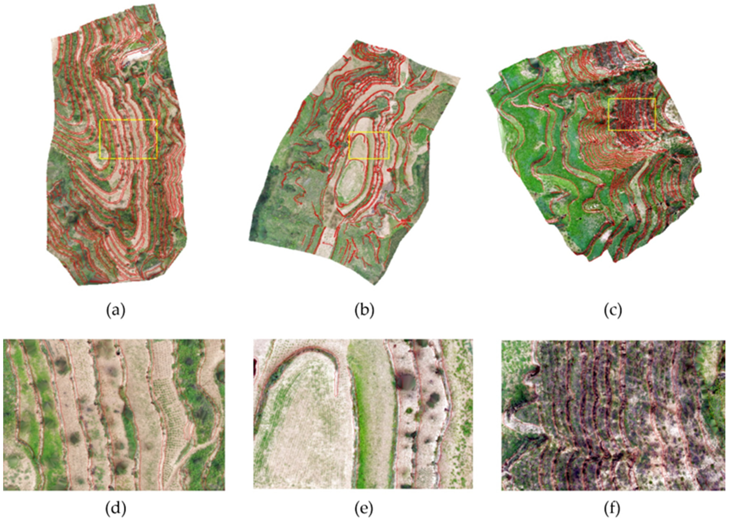
The terrace ridges were extracted from the slope pictures of the terrace DEMs with 0.2 m resolution. The DOM pictures of the terraces have too many colours, vegetation cover and other ground features. The ridges are clearer in the slope pictures than in the DOM pictures of terraces. These slope pictures are grayscale pictures converted from slope grids. The ridges were extracted by a Canny edge detector (Figure 3) and tracked by ArcScan. The terrace platforms have many short lines. These short lines are not the ridges of terraces. The length thresholds were used to filter out the false positives in this process [41]. The lines longer than 10 m were extracted (Figure 4).
The accuracy indices, namely, completeness, correctness and quality [59], were calculated to assess the linear features extracted from the slope pictures (Table 2). The reference terrace ridges were obtained through visual interpretation, and the buffer zone around each reference ridge was constructed. The extracted ridges falling within the buffer zones were considered as correct detection. The completeness indices of the three study areas were more than 100% because the reference ridges were obtained from the DOM pictures via visual interpretation. Moreover, the extracted ridges were obtained from the slope pictures. Some topographic reliefs were not visible from the DOM pictures. In addition, the extracted ridges were tracked through the pixels in the Canny edge detector results with 0.2 m resolution. The reference ridges are more generalised than the extracted ridges because of the view scale of visual interpretation. Therefore, the completeness index is less reliable than the correctness and quality indices in the present study.
Table 2 shows that the correctness and the quality indices of the S1 and S3 areas are better than those of the S2 area. The erosion of the S2 area is the most serious because this region has many gullies and collapses. The Canny edge detector can extract all the edges, including the ridges and edges of the gully and collapse in the study areas. The ridges extracted from the S2 area have the lowest percentage amongst all the extracted edges. The edges of the gully and collapse were not filtered out well. The two reasons above contribute to the lowest correctness index of the S2 area. However, the position and shape of the extracted ridges reaches high accuracy, which can be used for the subsequent DEM reconstruction and the evaluation of the damage degree of terrace ridges.

3.2. DEM Reconstruction Results

The undamaged terrace ridges were restored from the extracted results. The bottom edges of terrace walls were formed by parallel shifting the copy of the top edges by some distances. The angle of the terrace wall declination is 80°, which is from the construction criteria of terraces. The distances of the S1 and S2 areas are 0.56 and 0.62 m, respectively. The shifted distances of the terrace top edges in the S3 area are different because this area combines mechanical and artificial terraces. The distance of the artificial terraces in the S3 area is 0.53 m. The altitude differences of the adjacent terrace platforms in the mechanical terrace area are between 8 and 12 m, and the declination angle of the terrace walls in this area is 85°. Therefore, the distances are between 0.7 and 1.05 m.
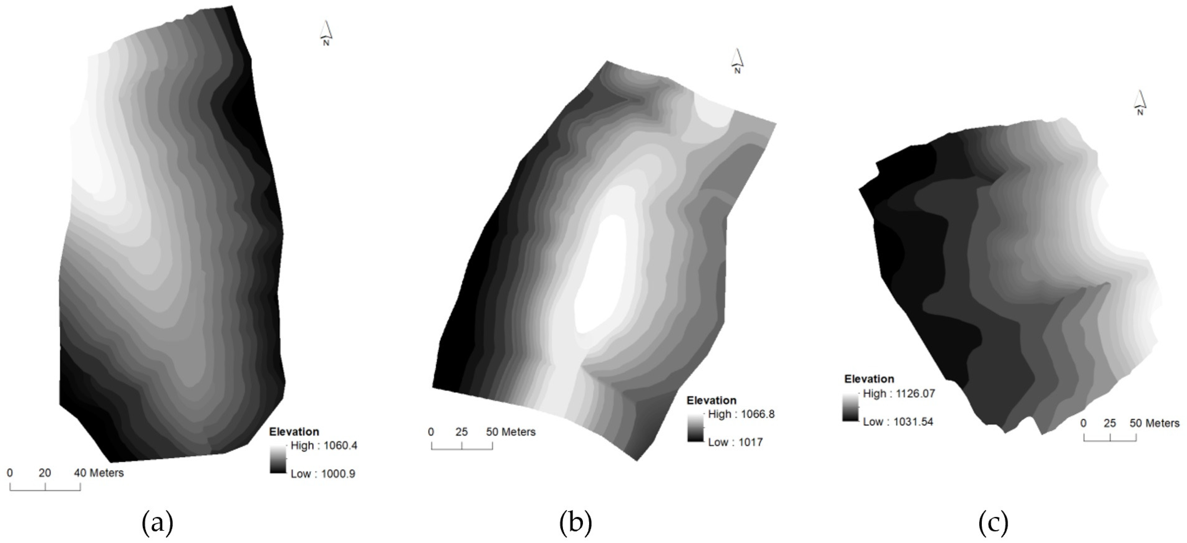
The altitude of each terrace platform in the restored DEM is the average altitude of each terrace platform in the damaged DEM, which is the result of the zonal mean statistics on the values of the damaged DEM within the terrace platform zones enclosed by the extracted edges. The restored DEMs with 0.2 m resolution were interpolated from the constrained TINs, which were constructed by the generated ridges with altitude (Figure 5).

3.3. Damage Degree of Terraces

3.3.1. Damage Degree of Terrace Ridges

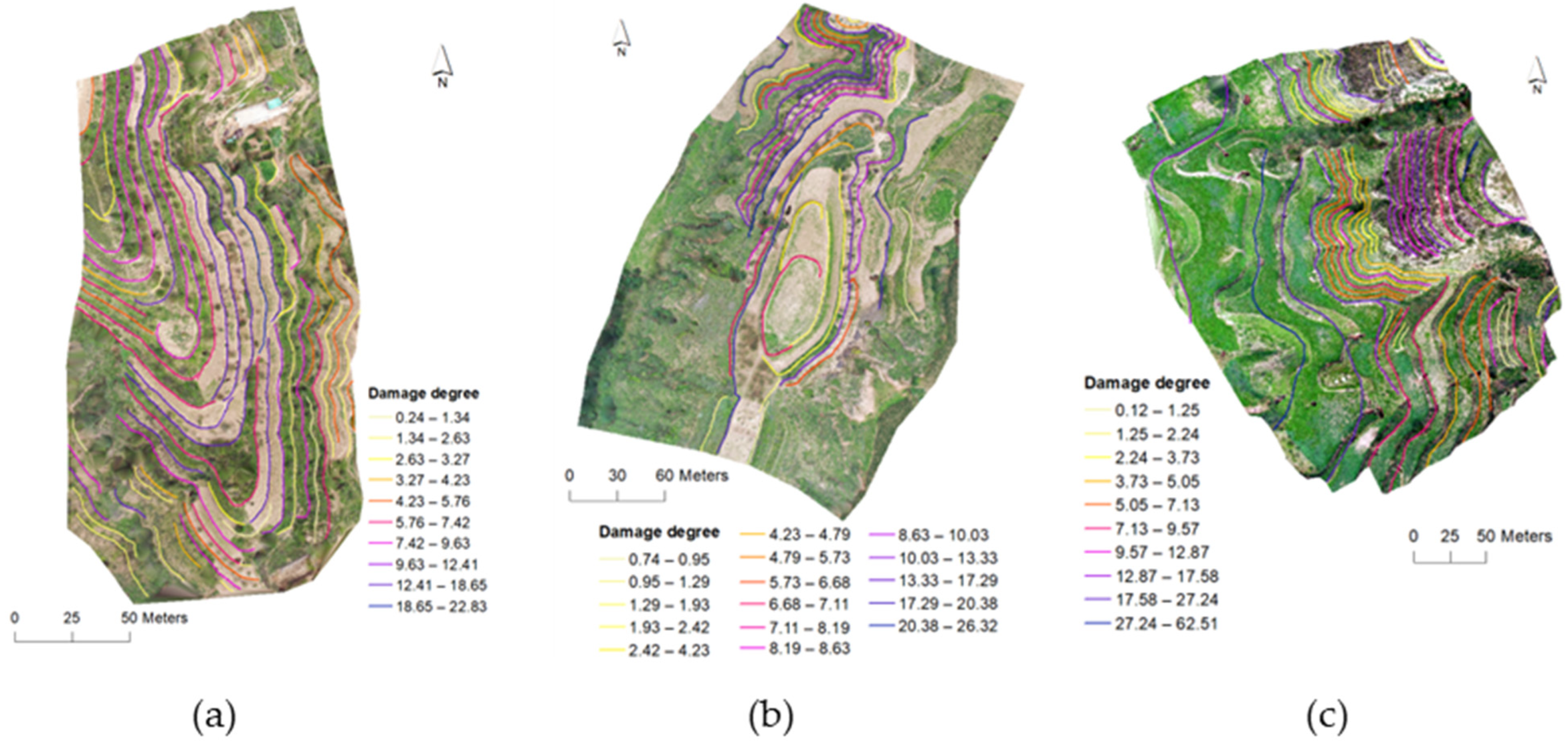
The damage degree of the terrace ridges was calculated according to the lengths of the extracted edges and the undamaged edges (Figure 6). The larger the value is, the more serious the terrace ridge damages are. The average values of the damage degree of the terrace ridges in S1, S2 and S3 areas are 7.05, 8.44 and 10.07, respectively. According to the average values, the terrace ridges of the S3 area were most seriously eroded. Based on the statistics of the damage degree of terrace ridges, the percentages of terrace ridges of which damage degree is greater than 10 in the three study areas are 21.74%, 29.73% and 39.68%, respectively (Table 3).

3.3.2. Damage Degree of Terrace Surfaces

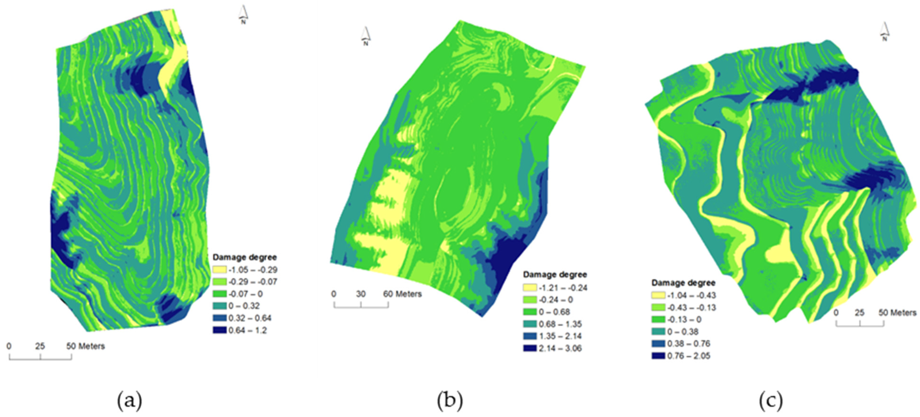
The damage degree of terrace surfaces was calculated based on the differences between undamaged and damaged DEMs (Figure 7). Therefore, the damage degree values of grids represent the damage degrees of cells on terrace surfaces. The negative values for the terrace cells indicate sediment accumulation; conversely, positive values indicate erosion. The minimum and maximum damage degree values of terrace surfaces in the S1 area are −1.05 and 1.2. The minimum and maximum values in the S2 area are −1.21 and 3.06. The minimum and maximum values in the S3 area are −1.04 and 2.05. According to the statistical result of damage degree of terrace surfaces, the percentages of erosion in three study areas are 51.53%, 74.25% and 52.47%, respectively (Table 4).

3.3.3. Damage Degree of a Whole Terrace

The damage degrees of the whole terraces in the S1, S2 and S3 areas are 0.12, 0.38 and 0.18, respectively. The damage degree of the S2 area is the largest, followed by the S3 and S1 areas. This finding is aligned with reality. The damage to the terrace in the S1 area is mainly described as terrace ridge damage. Moreover, few gullies and collapses exist, and the main structure of the terrace in the S1 area is relatively complete. Most of the S2 area, particularly in the middle and bottom, has formed gullies and collapses. Only the top retained the morphology of the terrace. In the S3 area, the main damage to the terrace includes the gullies formed at the large bend of the artificial terrace walls and the few collapses and accumulation in the low mechanical terrace. The damage degree of terraces indicates that the S2 area is the most severe, the S3 area is the second, and the S1 area is the least serious.

4. Discussion

4.1. Rationality of the Proposed Method

The degradation of terraces in many parts of the world has received attention, including Nepal [63], Spain [33,64], Peru [14], Tunisia [33] and Italy [15,26]. In the case study of three terraces located in northern, central and southern Italy, cracks, pipeline flow traces, small collapses and landslides were found on the slope of abandoned terraces [6]. A study of terraced landscapes in Spain found topographic evidence of large-scale soil movement [26]. The investigation of degraded terraced fields on the Loess Plateau showed that the collapse of ridges is common [36]. These studies showed that the surface microtopography of terraced fields is important evidence of terrace degradation, indicating that evaluating the degradation status of terraced fields from a topographic perspective is reasonable. UAVs have been widely applied in the research of terrace degradation worldwide because of their high accuracy and flexibility in acquisition [17,33,34,35,36]. The study cases from Spain [64] and Italy [26] confirmed that DEMs are reliable in exploring the spatial distribution of terrace degradation from different periods. The damage degrees of the terrace, which are quantitative indices for the terrace degradation assessment, were obtained from the changes in terrain morphology and characteristics. The increasing age of terrace abandonment results in the gradual destruction of the terrace walls because of the possible water concentration, high-soil saturation, soil crusts, macropore flux of runoff, piping and consequent terrace wall collapse and gully erosion [17,27,31]. In terms of topographic changes, terrace degradation is mainly reflected in the damage to terrace edges and the collapse of terrace platforms. Thus, the degradation of terraces can be quantified from the damage to terrace edges, the damage to terrace surface and the damage to terrace volume. In terms of the damage degree of the terrace surface, the erosion is severe in the middle and at the bottom of the abandoned terraces; this finding is aligned with the published literature [5,20,26,27].

4.2. Influence of DEM Resolution on Extracting Terrace Ridges

The extraction of terrace ridges is the basis of the present study. The Canny edge detector is well known for its simplicity and good performance. However, the low and high thresholds of the Canny are often obtained through an artificial setting or Otsu; these thresholds are not adaptive to various images [59,61]. In this study, the low and high thresholds are automatically calculated via the adaptive method, which ensures the low complexity of the Canny edge detector and the high-edge continuity and accuracy. Nevertheless, the results of terrace ridge extraction are still affected by DEM resolution (Figure 8). The position of the extracted edges is very accurate when the DEM with 0.1 m resolution is used; however, the extracted edges are discontinuous, and some parts of the edges are lost after filtering. The decrease in DEM resolution results in a decrease in the position accuracy of the extracted edges, reduction of details and an increase in continuity. Given the morphology, position accuracy and continuity of the extracted terrace ridges, the DEM with 0.2 m resolution is the best choice. As a result, a proper DEM resolution is crucial.
Because the high-resolution DEM can depict the microrelief of the terrace surface, many edges on the terrace platform, which are unnecessary, have also been extracted. Therefore, the filter process of extracted edges is required. The filter threshold is 6 m when the DEM resolution is 0.1 m, indicating that the length of the extracted edge longer than 6 m is reserved. Some parts of terrace ridges are filtered out, but the edges on terrace platforms are preserved. The filter threshold is 10 m when the DEM resolution is 0.2, 0.3, 0.4 and 0.5 m. The extraction edges on the terrace platform are reduced with the decrease in the DEM resolution because the gradient jump caused by the microrelief on the terrace platform decreases.

5. Conclusions

As an artificial landform, terraces are common around the world. They can increase grain yield and conserve water and soil. The abandonment of agricultural terraces in the Loess Plateau has increased over the past few decades in many regions. This scenario leads to serious soil erosion in degrading terraces because of the lacking maintenance and vegetation cover and heavy rainfall, which has drawn increasing attention. The high-resolution DTM data obtained by UAV photogrammetry technology support the quantification of terrace degradation. In this study, the terrace ridges were extracted by a Canny edge detector from the high-resolution DEM. On this basis, the DEM before terrace degradation was restored through digital terrain analysis methods. A DEM with appropriate resolution must be selected to ensure the extraction accuracy of terrace ridges. Then, the damage degree of terraces can be described from the line, surface, and volume aspects. The proposed indices can accurately reflect the degradation degrees of terraces and the soil erosion status of the terraces in topography. This work is helpful to reveal the terrain evolution patterns during terrace degradation and could provide references for terrace landscape protection and its sustainable management.

Author Contributions

Conceptualization, X.F.; methodology, X.F. and Y.Z.; software, X.F. and Y.Z.; validation, X.F. and Z.G.; formal analysis, X.F. and Z.G.; investigation, X.F.; resources, X.F.; writing—original draft preparation, X.F. and Y.Z.; writing—review and editing, X.F., Y.Z; funding acquisition, X.F., Z.G. and Y.Z. All authors have read and agreed to the published version of the manuscript.

Funding

This research was funded by the Natural Science Foundation of China (Nos. 41871313, 41401441 and 41501487), the Natural Science Foundation of Jiangsu Province (No. BK20161118), the Hydrology and Water Resources Survey Bureau of Jiangsu Province, Wuxi Branch Research Project (No. JSJGWXCG2022-08) and the Major Science and Technology Project of the Ministry of Water Resources (No. SKR-2022037).

Data Availability Statement

The data presented in this study are available on request from the corresponding author.

Acknowledgments

We are grateful for Mingguo Peng and Erdeng Du’s help with revising the manuscript.

Conflicts of Interest

The authors declare no conflict of interest.

References

  1. Capolupo, A.; Kooistra, L.; Boccia, L. A novel approach for detecting agricultural terraced landscapes from historical and contemporaneous photogrammetric aerial photos. Int. J. Appl. Earth Obs. Geoinf. 2018, 73, 800–810. [Google Scholar] [CrossRef]
  2. Wen, Y.; Kasielke, T.; Li, H.; Zhang, B.; Zepp, H. May agricultural terraces induce gully erosion? A case study from the Black Soil Region of Northeast China. Sci. Total Environ. 2021, 750, 141715. [Google Scholar] [CrossRef] [PubMed]
  3. Yang, L.; Liu, M.; Lun, F.; Min, Q.; Zhang, C.; Li, H. Livelihood assets and strategies among rural households: Comparative analysis of rice and dryland terrace systems in China. Sustainability 2018, 10, 2525. [Google Scholar] [CrossRef] [Green Version]
  4. Lasanta, T.; Arnáez, J.; Oserín, M.; Ortigosa, L.M. Marginal lands and erosion in terraced fields in the Mediterranean mountains. Mt. Res. Dev. 2001, 21, 69–76. [Google Scholar] [CrossRef] [Green Version]
  5. Cammeraat, E.L. Scale dependent thresholds in hydrological and erosion response of a semi-arid catchment in southeast Spain. Agric. Ecosyst. Environ. 2004, 104, 317–332. [Google Scholar] [CrossRef]
  6. Tarolli, P.; Preti, F.; Romano, N. Terraced landscapes: From an old best practice to a potential hazard for soil degradation due to land abandonment. Anthropocene 2014, 6, 10–25. [Google Scholar] [CrossRef]
  7. Dorren, L.; Rey, F. A Review of the Effect of Terracing on Erosion; Briefing Papers of the 2nd SCAPE Workshop; Citeseer: Cinque Terre, Italy, 2004; pp. 97–108. [Google Scholar]
  8. Li, L.; Tonts, M. The impacts of temporary labour migration on farming systems of the Loess Plateau, Gansu Province, China. Popul. Space Place 2014, 20, 316–332. [Google Scholar] [CrossRef]
  9. Camera, C.; Djuma, H.; Bruggeman, A.A.; Zoumides, C.; Eliades, M.; Charalambous, K.; Abate, D.; Faka, M. Quantifying the effectiveness of mountain terraces on soil erosion protection with sediment traps and dry-stone wall laser scans. Catena 2018, 171, 251–264. [Google Scholar] [CrossRef]
  10. Socci, P.; Errico, A.; Castelli, G.; Penna, D.; Preti, F. Terracing: From agriculture to multiple ecosystem services. In Oxford Research Encyclopedia of Environmental Science; Oxford University Press: New York, NY, USA, 2019. [Google Scholar]
  11. Stavi, I.; Gusarov, Y.; Halbac-Cotoara-Zamfir, R. Collapse and failure of ancient agricultural stone terraces: On-site geomorphic processes, pedogenic mechanisms, and soil quality. Geoderma 2019, 344, 144–152. [Google Scholar] [CrossRef]
  12. Cicinelli, E.; Caneva, G.; Savo, V. A review on management strategies of the terraced agricultural systems and conservation actions to maintain cultural landscapes around the Mediterranean Area. Sustainability 2021, 13, 4475. [Google Scholar] [CrossRef]
  13. Sáez, E.; Canziani, J. Vernacular architecture and cultural landscapes in the Sondondo valley (Peru). Int. Arch. Photogramm. Remote Sens. Spat. Inf. Sci. 2020, 44, 175–180. [Google Scholar] [CrossRef]
  14. Ishizawa, M. Landscape change in the terraces of Ollantaytambo, Peru: An emergent mountain landscape between the urban, rural and protected area. Landsc. Res. 2017, 42, 321–333. [Google Scholar] [CrossRef]
  15. Paliaga, G.; Luino, F.; Turconi, L.; De Graff, J.V.; Faccini, F. Terraced landscapes on portofino promontory (Italy): Identification, geo-hydrological hazard and management. Water 2020, 12, 435. [Google Scholar] [CrossRef] [Green Version]
  16. Díaz, A.R.; Sanleandro, P.M.; Soriano, A.S.; Serrato, F.B.; Faulkner, H. The causes of piping in a set of abandoned agricultural terraces in southeast Spain. Catena 2007, 69, 282–293. [Google Scholar] [CrossRef]
  17. Lesschen, J.; Cammeraat, L.; Nieman, T. Erosion and terrace failure due to agricultural land abandonment in a semi-arid environment. Earth Surf. Process. Landf. J. Br. Geomorphol. Res. Group 2008, 33, 1574–1584. [Google Scholar] [CrossRef]
  18. Kizos, T.; Dalaka, A.; Petanidou, T. Farmers’ attitudes and landscape change: Evidence from the abandonment of terraced cultivations on Lesvos, Greece. Agric. Hum. Values 2010, 27, 199–212. [Google Scholar] [CrossRef] [Green Version]
  19. Gravagnuolo, A.; Varotto, M. Terraced Landscapes Regeneration in the Perspective of the Circular Economy. Sustainability 2021, 13, 4347. [Google Scholar] [CrossRef]
  20. Moreno-de-las-Heras, M.; Lindenberger, F.; Latron, J.; Lana-Renault, N.; Llorens, P.; Arnáez, J.; Romero-Díaz, A.; Gallart, F. Hydro-geomorphological consequences of the abandonment of agricultural terraces in the Mediterranean region: Key controlling factors and landscape stability patterns. Geomorphology 2019, 333, 73–91. [Google Scholar] [CrossRef]
  21. Tarolli, P.; Rizzo, D.; Brancucci, G. Terraced Landscapes: Land Abandonment, Soil Degradation, and Suitable Management. In World Terraced Landscapes: History, Environment, Quality of Life; Springer: Berlin/Heidelberg, Germany, 2019; pp. 195–210. [Google Scholar]
  22. Sidle, R.C.; Ziegler, A.D.; Negishi, J.N.; Nik, A.R.; Siew, R.; Turkelboom, F. Erosion processes in steep terrain—Truths, myths, and uncertainties related to forest management in Southeast Asia. For. Ecol. Manag. 2006, 224, 199–225. [Google Scholar] [CrossRef]
  23. Bazzoffi, P.; Gardin, L. Effectiveness of the GAEC standard of cross compliance retain terraces on soil erosion control. Ital. J. Agron. 2011, 6, e6. [Google Scholar] [CrossRef] [Green Version]
  24. Wickama, J.; Okoba, B.; Sterk, G. Effectiveness of sustainable land management measures in West Usambara highlands, Tanzania. Catena 2014, 118, 91–102. [Google Scholar] [CrossRef]
  25. Gallart, F.; Llorens, P.; Latron, J. Studying the role of old agricultural terraces on runoff generation in a small Mediterranean mountainous basin. J. Hydrol. 1994, 159, 291–303. [Google Scholar] [CrossRef]
  26. Brandolini, P.; Cevasco, A.; Capolongo, D.; Pepe, G.; Lovergine, F.; Del Monte, M. Response of terraced slopes to a very intense rainfall event and relationships with land abandonment: A case study from Cinque Terre (Italy). Land Degrad. Dev. 2018, 29, 630–642. [Google Scholar] [CrossRef]
  27. Sabir, M. The terraces of the anti-atlas: From abandonment to the risk of degradation of a landscape heritage. Water 2021, 13, 510. [Google Scholar] [CrossRef]
  28. Agnoletti, M.; Errico, A.; Santoro, A.; Dani, A.; Preti, F. Terraced landscapes and hydrogeological risk. Effects of land abandonment in Cinque Terre (Italy) during severe rainfall events. Sustainability 2019, 11, 235. [Google Scholar] [CrossRef] [Green Version]
  29. Palmer, C.; Colledge, S.; Bevan, A.; Conolly, J. Vegetation recolonisation of abandoned agricultural terraces on Antikythera, Greece. Environ. Archaeol. 2010, 15, 64–80. [Google Scholar] [CrossRef] [Green Version]
  30. Koulouri, M.; Giourga, C. Land abandonment and slope gradient as key factors of soil erosion in Mediterranean terraced lands. Catena 2007, 69, 274–281. [Google Scholar] [CrossRef]
  31. Christiansen, M.P.; Laursen, M.S.; Jørgensen, R.N.; Skovsen, S.; Gislum, R. Designing and testing a UAV mapping system for agricultural field surveying. Sensors 2017, 17, 2703. [Google Scholar] [CrossRef] [Green Version]
  32. Chidi, C.L.; Zhao, W.; Chaudhary, S.; Xiong, D.H.; Wu, Y.H. Sensitivity assessment of spatial resolution difference in DEM for soil erosion estimation based on UAV observations: An experiment on agriculture terraces in the middle hill of Nepal. ISPRS Int. J. Geo-Inf. 2021, 10, 28. [Google Scholar] [CrossRef]
  33. Schönbrodt-Stitt, S.; Behrens, T.; Schmidt, K.; Shi, X.; Scholten, T. Degradation of cultivated bench terraces in the Three Gorges Area: Field mapping and data mining. Ecol. Indic. 2013, 34, 478–493. [Google Scholar] [CrossRef]
  34. Cucchiaro, S.; Fallu, D.J.; Zhang, H.; Walsh, K.; Van Oost, K.; Brown, A.G.; Tarolli, P. Multiplatform-SfM and TLS data fusion for monitoring agricultural terraces in complex topographic and landcover conditions. Remote Sens. 2020, 12, 1946. [Google Scholar] [CrossRef]
  35. Pijl, A.; Quarella, E.; Vogel, T.A.; D’Agostino, V.; Tarolli, P. Remote sensing vs. field-based monitoring of agricultural terrace degradation. Int. Soil Water Conserv. Res. 2021, 9, 1–10. [Google Scholar] [CrossRef]
  36. Fang, X.; Li, J.; Zhu, Y.; Cao, J.; Na, J.; Jiang, S.; Ding, H. OBIA-Based Extraction of Artificial Terrace Damages in the Loess Plateau of China from UAV Photogrammetry. ISPRS Int. J. Geo-Inf. 2021, 10, 805. [Google Scholar] [CrossRef]
  37. Fu, B. Soil erosion and its control in the Loess Plateau of China. Soil Use Manag. 1989, 5, 76–82. [Google Scholar] [CrossRef]
  38. Fu, B.; Wang, S.; Liu, Y.; Liu, J.; Liang, W.; Miao, C. Hydrogeomorphic ecosystem responses to natural and anthropogenic changes in the Loess Plateau of China. Annu. Rev. Earth Planet. Sci. 2017, 45, 223–243. [Google Scholar] [CrossRef]
  39. An, P.; Inoue, T.; Zheng, M.; Eneji, A.E.; Inanaga, S. Agriculture on the loess plateau. In Restoration and Development of the Degraded Loess Plateau, China; Springer: Berlin/Heidelberg, Germany, 2014; pp. 61–74. [Google Scholar]
  40. Cao, S.; Xu, C.; Chen, L.; Wang, X. Attitudes of farmers in China’s northern Shaanxi Province towards the land-use changes required under the Grain for Green Project, and implications for the project’s success. Land Use Policy 2009, 26, 1182–1194. [Google Scholar] [CrossRef]
  41. Delang, C.O.; Yuan, Z. China’s Grain for Green Program; Springer: Berlin/Heidelberg, Germany, 2016. [Google Scholar]
  42. Feng, Z.; Yang, Y.; Zhang, Y.; Zhang, P.; Li, Y. Grain-for-green policy and its impacts on grain supply in West China. Land Use Policy 2005, 22, 301–312. [Google Scholar] [CrossRef]
  43. Wei, J.-Z.; Zheng, K.; Zhang, F.; Fang, C.; Zhou, Y.-Y.; Li, X.-C.; Li, F.-M.; Ye, J.-S. Migration of rural residents to urban areas drives grassland vegetation increase in China’s Loess Plateau. Sustainability 2019, 11, 6764. [Google Scholar] [CrossRef] [Green Version]
  44. Zhao, H.; Fang, X.; Ding, H.; Strobl, J.; Xiong, L.; Na, J.; Tang, G. Extraction of terraces on the Loess Plateau from high-resolution DEMs and imagery utilizing object-based image analysis. ISPRS Int. J. Geo-Inf. 2017, 6, 157. [Google Scholar] [CrossRef] [Green Version]
  45. Dai, W.; Na, J.; Huang, N.; Hu, G.; Yang, X.; Tang, G.; Xiong, L.; Li, F. Integrated edge detection and terrain analysis for agricultural terrace delineation from remote sensing images. Int. J. Geogr. Inf. Sci. 2020, 34, 484–503. [Google Scholar] [CrossRef]
  46. Luo, L.; Li, F.; Dai, Z.; Yang, X.; Liu, W.; Fang, X. Terrace extraction based on remote sensing images and digital elevation model in the loess plateau, China. Earth Sci. Inform. 2020, 13, 433–446. [Google Scholar] [CrossRef]
  47. Ding, H.; Na, J.; Jiang, S.; Zhu, J.; Liu, K.; Fu, Y.; Li, F. Evaluation of three different machine learning methods for object-based artificial terrace mapping—A case study of the loess plateau, China. Remote Sens. 2021, 13, 1021. [Google Scholar] [CrossRef]
  48. Na, J.; Ding, H.; Zhao, W.; Liu, K.; Tang, G.; Pfeifer, N. Object-based large-scale terrain classification combined with segmentation optimization and terrain features: A case study in China. Trans. GIS 2021, 25, 2939–2962. [Google Scholar] [CrossRef]
  49. Zhao, F.; Xiong, L.Y.; Wang, C.; Wang, H.R.; Wei, H.; Tang, G.A. Terraces mapping by using deep learning approach from remote sensing images and digital elevation models. Trans. GIS 2021, 25, 2438–2454. [Google Scholar] [CrossRef]
  50. Lü, H.; Zhu, Y.; Skaggs, T.H.; Yu, Z. Comparison of measured and simulated water storage in dryland terraces of the Loess Plateau, China. Agric. Water Manag. 2009, 96, 299–306. [Google Scholar] [CrossRef]
  51. Liu, X.; He, B.; Li, Z.; Zhang, J.; Wang, L.; Wang, Z. Influence of land terracing on agricultural and ecological environment in the loess plateau regions of China. Environ. Earth Sci. 2011, 62, 797–807. [Google Scholar] [CrossRef]
  52. Xu, G.; Zhang, T.; Li, Z.; Li, P.; Cheng, Y.; Cheng, S. Temporal and spatial characteristics of soil water content in diverse soil layers on land terraces of the Loess Plateau, China. Catena 2017, 158, 20–29. [Google Scholar] [CrossRef]
  53. Bai, J.; Yang, S.; Zhang, Y.; Liu, X.; Guan, Y. Assessing the impact of terraces and vegetation on runoff and sediment routing using the time-area method in the Chinese Loess Plateau. Water 2019, 11, 803. [Google Scholar] [CrossRef] [Green Version]
  54. Ran, Q.; Chen, X.; Hong, Y.; Ye, S.; Gao, J. Impacts of terracing on hydrological processes: A case study from the Loess Plateau of China. J. Hydrol. 2020, 588, 125045. [Google Scholar] [CrossRef]
  55. Xu, Q.; Li, W.-L.; Ju, Y.-Z.; Dong, X.-J.; Peng, D.-L. Multitemporal UAV-based photogrammetry for landslide detection and monitoring in a large area: A case study in the Heifangtai terrace in the Loess Plateau of China. J. Mt. Sci. 2020, 17, 1826–1839. [Google Scholar] [CrossRef]
  56. Xu, Y.; Zhu, G.; Wan, Q.; Yong, L.; Ma, H.; Sun, Z.; Zhang, Z.; Qiu, D. Effect of terrace construction on soil moisture in rain-fed farming area of Loess Plateau. J. Hydrol. Reg. Stud. 2021, 37, 100889. [Google Scholar] [CrossRef]
  57. Huang, C.; Yang, Q.; Cao, X.; Li, Y. Assessment of the soil erosion response to land use and slope in the loess plateau—A case study of jiuyuangou. Water 2020, 12, 529. [Google Scholar] [CrossRef] [Green Version]
  58. Pijl, A.; Bailly, J.-S.; Feurer, D.; El Maaoui, M.A.; Boussema, M.R.; Tarolli, P. TERRA: Terrain extraction from elevation rasters through repetitive anisotropic filtering. Int. J. Appl. Earth Obs. Geoinf. 2020, 84, 101977. [Google Scholar] [CrossRef]
  59. Dai, W.; Hu, G.; Huang, N.; Zhang, P.; Yang, X.; Tang, G. A contour-directional detection for deriving terrace ridge from open source images and digital elevation models. IEEE Access 2019, 7, 129215–129224. [Google Scholar] [CrossRef]
  60. Ziou, D.; Tabbone, S. Edge detection techniques-an overview. Pattern Recognit. Image Anal. C/C Raspoznavaniye Obraz. I Anal. Izobr. 1998, 8, 537–559. [Google Scholar]
  61. Maini, R.; Aggarwal, H. Study and comparison of various image edge detection techniques. Int. J. Image Process. 2009, 3, 1–11. [Google Scholar]
  62. Canny, J. A computational approach to edge detection. In IEEE Transactions on Pattern Analysis and Machine Intelligence; IEEE: Los Alamitos, CA, USA, 1986; pp. 679–698. [Google Scholar]
  63. Khanal, N.R.; Watanabe, T. Abandonment of agricultural land and its consequences: A case study in the Sikles area, Gandaki Basin, Nepal Himalaya. Mt. Res. Dev. 2006, 26, 32. [Google Scholar] [CrossRef] [Green Version]
  64. Martínez-Casasnovas, J.A.; Ramos, M.C.; Cots-Folch, R. Influence of the EU CAP on terrain morphology and vineyard cultivation in the Priorat region of NE Spain. Land Use Policy 2010, 27, 11–21. [Google Scholar] [CrossRef]
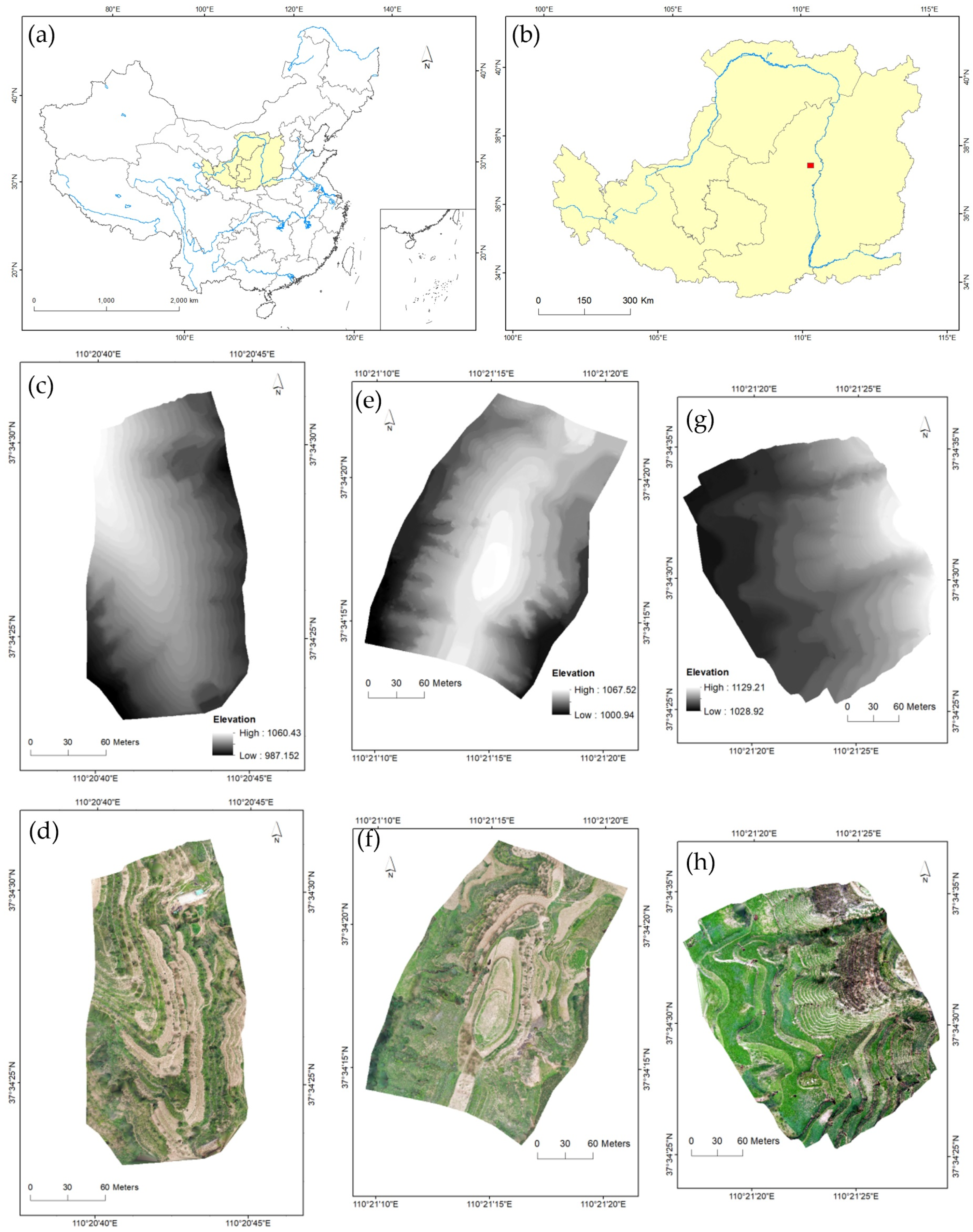
Figure 1. The study areas and data. (a) Location of Loess Plateau, China. (b) Location of the study area. (c,e,g) The DEMs of the S1, S2 and S3 area, respectively. (d,f,h) The Digital Orthograph Models (DOM) obtained from UAV photogrammetry of the S1, S2 and S3 area, respectively.
Sustainability 15 10800 g001
Figure 2. Workflow of this study.
Sustainability 15 10800 g002
Figure 3. The results of Canny edge detector in the three study areas. (ac) The results of the S1, S2 and S3 area, respectively. (df) The enlarged parts of the results in the S1, S2 and S3 area, respectively.
Sustainability 15 10800 g003
Figure 4. The vector lines of extracted ridges. (ac) The results of the S1, S2 and S3 area, respectively. (df) The enlarged parts of the results in the S1, S2 and S3 area, respectively.
Sustainability 15 10800 g004
Figure 5. Reconstructed DEMs of the three study areas. (ac) The results of the S1, S2, S3 area, respectively.
Sustainability 15 10800 g005
Figure 6. The damage degree of terrace ridges. (ac) The results of the S1, S2, S3 area, respectively.
Sustainability 15 10800 g006
Figure 7. The damage degree of terrace surfaces. (ac) The results of the S1, S2 and S3 area, respectively.
Sustainability 15 10800 g007
Figure 8. Terrace ridges extracted from the DEM with a different resolution in the S1 area. (a,c,e,g,i) The results extracted by the Canny edge detector are based on the DEM with 0.1 m, 0.2 m, 0.3 m, 0.4 m and 0.5 m resolution, respectively. (b,d,f,h,j) The terrace ridges in vector format are tracked and filtered based on Canny results.
Sustainability 15 10800 g008
Table 1. The topographic information and terrace parameters of the three study areas.
Study AreaS1S2S3
Average Altitude (m)1026.131042.781068.50
Average Slope (°)28.735.5225.9
Average Wall Height (m)3.193.53.79
Average Platform Width (m)4.864.996.36
Area (ha)2.825.446.45
Table 2. The accuracy indices of extracted ridges in the three study areas.
Study AreasS1S2S3
Completeness103.01%121.47%127.88%
Correctness93.54%50.68%71.63%
Quality96.17%55.67%85.03%
Table 3. The statistical result of damage degree of terrace ridges in the three study areas.
Damage Degree of Terrace RidgesPercentage in First Study Area (%)Percentage in Second Study Area (%)Percentage in Third Study Area (%)
0–15.85.417.94
1–320.2918.9219.05
3–514.498.1112.7
5–1037.6837.8420.63
10–2020.2921.6231.75
20–301.458.114.76
>30003.17
Table 4. The statistical result of damage degree of terrace surfaces in the three study areas.
Damage Degree of Terrace SurfacesPercentage in First Study Area (%)Percentage in Second Study Area (%)Percentage in Third Study Area (%)
<−100.080
−1~−0.50.572.666.77
−0.5~047.8923.0140.77
0~0.546.250.6446.77
0.5~15.0413.614.44
1~1.50.294.381.21
1.5~202.470.05
2~2.501.920
>2.501.230
Disclaimer/Publisher’s Note: The statements, opinions and data contained in all publications are solely those of the individual author(s) and contributor(s) and not of MDPI and/or the editor(s). MDPI and/or the editor(s) disclaim responsibility for any injury to people or property resulting from any ideas, methods, instructions or products referred to in the content.