Article

Heritage-Based Spatial Form Consideration: Western Urban Planning Concepts Used in Chinese Urban (Dalian) Development

School of Architecture and Urban Planning, Suzhou University of Science and Technology, Suzhou 215011, China
*
Author to whom correspondence should be addressed.
Sustainability 2023, 15(14), 10899; https://doi.org/10.3390/su151410899
Submission received: 23 March 2023 / Revised: 29 May 2023 / Accepted: 30 June 2023 / Published: 12 July 2023
(This article belongs to the Special Issue Sustainable Conservation of Urban and Cultural Heritage)

Abstract

:
Dalian, a typical modern colonial city, originated in the late 19th century and was planned and built by Russian architects. Academics have traditionally focused on the unique qualities of the spatial form from the early stages of urban development, but due to a lack of urban history archives, the formation of the spatial form and the planning ideology of this time have not been examined. For this study, we visited the Russian State Historical Archives to search for relevant materials to restore the process of forming Dalian’s spatial form. Based on this, the heritage value and attributes of Dalian’s modern urban spatial form are discussed. The results show that, although Dalian was always under the control of Russian political power at the early stage of its urban construction, the urban planning ideas were integrated with modern Western urban planning ideas. Secondly, under the influence of modern Western urban planning ideas, including “classicalism” and the “garden city”, the modern Dalian urban space gradually formed a unique form and appearance, bearing the brand of the times and urban memory in a special context. Moreover, this study finds that the evolution of urban space is not simply a cumulative development of itself but the result of the influence of external ideas implanted with unique heritage values and attributes.

1. Introduction

1.1. Chinese Urban Spatial Form in the Modern Era and Colonial Planning

Politics and economics, as important gravitational forces for urban development [1], have guided changes and alterations in urban productivity and production methods [2] and bred new urban spatial layouts and planning ideas, and the resulting spatial forms bear the imprints of changing times, technological progress, and major events. Looking back at the history of China’s urban development, the Opium War impacted the natural economic development model and feudal autocracy and promoted the modernization of Chinese cities [3], from which the Western powers began colonial planning and regional construction in China.
The existing studies often rely on the existing urban history archives in China and adopt comparative analysis, typological methods, and field survey methods, focusing on describing and summarizing the characteristics of modern urban spatial forms and interpreting the differences in spatial forms and their causes in terms of social culture, productivity product development, and political system, which have made positive contributions to the knowledge of modern urban spatial forms in China. However, a comprehensive survey of planning history has been neglected, and the process of spatial form formation has not been systematically analyzed from the perspective of urban planning history, taking into account the lineage, dissemination, and practice of modern urban planning ideas. As a result, it is not possible to deeply realize the heritage properties of spatial form, which is important evidence of spatial form as cultural heritage and reflects the unique heritage value of spatial form in terms of humanistic thought, technological development, and political system.
After the mid-19th century, foreign powers began to continuously invade China in a vain attempt to control modern Chinese cities using colonial planning, from which unique spatial forms emerged. Shanghai was first transformed into a commercial port in 1843, and the Western powers established concessions there one after another, creating the unique space of “lanes” within the concessions. The “lane” in Shanghai is similar to a Western neighborhood, and the “lane” is a pathway within the neighborhood. By dividing and arranging the “main lane” and the “branch lane” within the neighborhood, the two are connected and diverted to each household to ensure the relative seclusion and quietness of the living space [4]. This checkerboard grid-like layout and simple unit development model is borrowed from the New York urban spatial layout in the United States and Birmingham townhouses in the United Kingdom [5]. The “lane” space was born out of the need for concentrated housing due to the rapid growth of the tenement and the population explosion and was able to balance the internal needs of the neighborhood with the external commercial trade [6].
Scholars have studied the spatial forms and types of “lanes” in detail in terms of spatial composition, structure, scale and boundaries, general layout and road network characteristics, and the history of Western urban planning [7]. At the same time, some scholars analyze the spatial utilization patterns and community perception boundaries of the “lane” from the perspective of social de-construction, arguing that the “lane” spatial form is a fast and convenient method of urban construction, which can provide living space for a large number of laborers while maintaining a low construction cost, catering to the requirements of colonial expansion and capital for profit [8] (see Figure 1).
After 1860, nine Western countries successively set up concessions in Tianjin, the total area of which was approximately ten times the size of Tianjin Wei Cheng (Old Tianjin City) [10]. By combining the spatial development of the Tianjin tenement, it is found that its space was influenced by the development of foreign industry and commerce in modern times, and its spatial form conformed to the technological innovation and productivity transformation of the time [11]. At the same time, when comparing the spatial patterns of the Tianjin Concession, it is easy to see the strong contrast between the four-sided layout of the Tianjin Acropolis and the concessions of various countries in terms of both street design and neighborhood scale, showing a heterogeneous collage of features in the old city area, the colonial concessions, and the suburban periphery of the city [12] (see Figure 2). In addition, the spatial pattern of Tianjin’s acropolis formed a square road network pattern of “acropolis in the middle”, which influenced the morphological development of the adjacent space (Tianjin Concession) to a certain extent [13].
Wuhan has been forcibly established as a leased territory by five Western countries since 1861, and its leased area is second only to Shanghai and Tianjin. The modern Wuhan urban space was influenced by multiple influences of colonial planning, industrial civilization, and Western culture, resulting in a new urban spatial form [15]. Unlike the fishbone street layout of “streets and alleys”, the streets of the leasehold were wide and neat, and the buildings were arranged in layers, showing a typical grid layout [16] (see Figure 3).
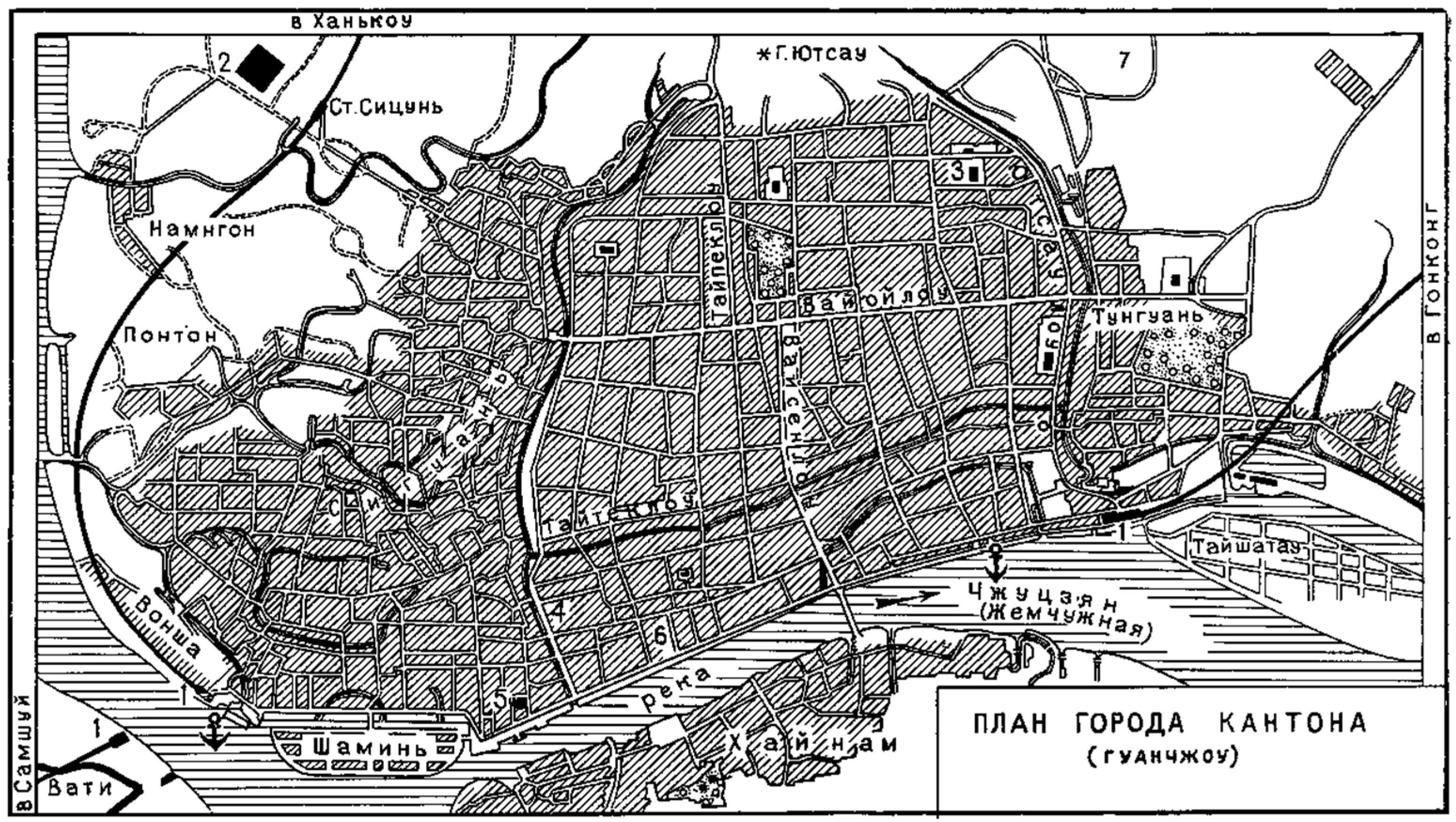
Compared to Shanghai, Tianjin, and Wuhan, the urban space of Qingdao was planned and built under the exclusive colonial rule of one country. In 1898, Germany established the privilege of ruling Tsingtao and invested nearly 200 million marks in its construction, trying to make it the largest commercial and industrial center of itself in the Far East, and the spatial form of the city showed a typical Baroque style [18]. In this way, it fulfilled the colonizer’s authoritarian tastes and expressive needs, manifested its power and status, and emphasized the core power of the colonizer. As a result, the spatial form of Qingdao exhibits similar characteristics to the urban planning in Versailles, France, and Washington, DC, USA [19]. In the layout of the neighborhood grid, the “neighborhood-radial” model is adopted, in which straight radial lines are crossed, cut, and interspersed in a square grid, and open spaces such as squares, parks, and monuments are arranged on top of the intersections [20] (see Figure 4).
Whether in terms of the spatial scale of the concessions or the geographical span of the concessions, the Chinese Eastern Railway Annex is a typical example of modern Chinese colonial planning. The Chinese Eastern Railway spans across Inner Mongolia, Heilongjiang, Jilin, and Liaoning provinces, with more than a hundred stations along the route, and a large number of railroad annexes have been created [22]. The influence of political forces on the control of urban spatial patterns in the Chinese Eastern railway dependencies has been discussed from a geopolitical perspective [23]. Meanwhile, some scholars took Harbin, a first-class station of the Chinese Eastern Railway, as an example, and explored the preservation and continuation of the spatial structure and form of “ring square, radial road, and central square” in the modern urban spatial form by mining the urban construction archives [24].

1.2. Chinese Eastern Railway and Modern Dalian Urban Spatial Form

Since the time of Peter the Great, Tsarist Russia advocated for the incorporation of European experience in urban planning and construction and established Russian cities such as St. Petersburg. A review of the history of Russian urban development found that a boom in urban construction occurred in Russia in the 18th century, continuing into the 19th and early 20th centuries [25]. An interpretation of Russian urban planning schemes from the late 19th century argued that for the urban planning schemes prepared during the early or mid-19th century, the influence of modern Western urban planning ideas had not yet been felt, and only the foreign urban planning schemes prepared during the 19th and 20th centuries (Russian colonies) appeared to be more substantial and high-quality changes [26]. The most influential innovations appeared in the Far East, where more than a hundred annexed towns, such as Lushun, Harbin, and Dalian, were established along the Chinese Eastern Railway in just a few years.
According to the Russian State Historical Archives [27], the Russian fleet occupied Lushun (also called “Port Arthur”) at the end of 1897. On 15 March of the following year, representatives of the Russian and Chinese sides signed an agreement on the lease of land for the construction of the Chinese Eastern Railway (25 years) in Beijing [28]. During the subsequent construction of the railroad, emphasis was placed on the creation of three nodal cities of the line: two seaport cities, namely, the military port of Lushun and the commercial port of Dalian, both of which were exits of the railroad to the Pacific Ocean and were located next to the beautiful and comfortable Liaodong Bay; and the third city, which was the commercial center and the largest hub of the entire Chinese Eastern Railway line, Harbin, which was located in the Songhua River. A comparative analysis revealed that the three cities born of the railroad are similar to each other in terms of urban vision, architectural style, and spatial design [29]. Some scholars argue that Dalian urban planning has avoided as much as possible the present unattractive and unreasonable tessellated spatial layout via “functional zoning” to avoid the above problems [30]. In addition, a comparative analysis of the spatial construction of towns along the Chinese Eastern Railway revealed that the architectural design features, public utility construction, and land use practices derived from Dalian’s urban construction and planning were applied to the construction of later railroad towns [31].
From the perspective of urban imagery, an examination of modern Dalian urban planning reveals that the city square is the most characteristic element of Dalian urban imagery [32]. In terms of spatial organization, façade form, and interior design, the modern Dalian residential class architectural design features and practices have had an important influence on the development of Dalian’s urban architectural form [33]. From the perspective of urban functions and development patterns, the development of modern urbanization in Dalian relied mainly on port trade as a means to promote modern urban spatial development [34]. Some scholars analyze the characteristics of the modern Dalian city blocks from the perspective of plot division and argue that its plot division has flexibility and elasticity to adapt to modern building types and scales, indicating that the role of the modern Dalian urban spatial structure has continued to this day [35]. Although urban planning studies of modern Dalian have been conducted for a long time, most of the existing studies have interpreted its urban characteristics and colonization development from a historical perspective. The studies on the space of modern Dalian have focused on the interpretation of architectural features, the impact of colonial construction, the summary of spatial characteristics, and the partial interpretation of planning schemes. On the whole, the urban planning of modern Dalian has not been systematically examined, and the process of forming the urban spatial form of modern Dalian has not been comprehensively interpreted.
In addition, studies have been conducted to demonstrate the similarities between the existing urban pattern of Dalian and the historical planning pattern in terms of architectural layout, urban characteristics, traffic features, and landscaping. For example, the existing urban pattern of Dalian retains the characteristics of the architectural construction and spatial layout of the Russian colonial period [36], while a part of the urban space retains intact the characteristics of the urban space formed during the Russian colonial period [37]. Second, the road network structure [38] and park system [39] formed during the Russian planning period are used to this day.
According to the Report on Port and City Construction of Dalian (1898–1904) [40], the city plan of Dalian was prepared in 1899 and went through several rounds of revisions by the architect K.G. Skolimovsky (К.Г. Скoлимoвский). This study finds that Dalian, as the first railroad town to develop a planning scheme, was influenced by both tsarist and Western planning ideas in its urban planning and is a typical case for studying modern urban planning ideas. However, due to the incompleteness of domestic urban history archives, the study of the urban spatial form of modern Dalian has not been carried out systematically. Therefore, for this study, we visited the Russian State Historical Archives to search for the archives of modern Dalian city construction. Through the interpretation of historical archives and analysis of planning cases, the process of the formation of the spatial form of the city is systematically and comprehensively restored. At the same time, the heritage attributes and values of its modern spatial form are discussed, which provide an important basis for the future conservation of urban spatial form and coordinated spatial development.
In addition, it must be stated that in the collection of Russian historical archives, although some planning drawings, as well as construction materials of the early period of Dalian city construction, were obtained, no direct written information was obtained to show the planning intentions of architects or planners. The significance of the study of the urban spatial form of Dalian during the Russian colonial period, including the preserved urban features, culture, spatial characteristics, etc., has been demonstrated by combining relevant documents, as mentioned above. However, the existing studies have not addressed the following: what planning ideas influenced the urban spatial form in the Russian colonial period? And how was it formed? This paper answers these research questions with the help of historical planning drawings, some construction materials, and relevant cases. Therefore, this study does not contradict the existing research but is a continuation and deepening of it.
At the same time, although academics have paid attention to the value of Dalian’s modern urban space, they have limited it to a single aspect, such as architectural layout, plot division, park system, and urban origin, etc., but have not examined the important value of Dalian’s modern urban space form from a planning perspective. In the current stage of China’s urbanization development, the pattern and form of the historical urban areas have not been effectively protected and given sufficient attention and have been damaged to different degrees. The above-mentioned spatial patterns are an important basis for urban cultural heritage protection and urban renewal. Through the study of Dalian’s modern urban spatial form, this paper tries to clarify its heritage attributes and unique values so that it can be properly handled and preserved continuously and completely in the future developments of the city.

2. Materials and Methods

2.1. Technique for Extracting Spatial Morphology

Spatial morphology is the crystallization of urban planning and construction ideas in different periods. Dhanani [41] analyzed the influencing factors of spatial morphology using historical geographic data reconstruction techniques and considered it a spatial representation of civilization developed in the same geographic unit in the context of different times. Xu et al. [42] used spatial syntax to analyze the evolutionary characteristics of spatial morphology and showed that, in terms of temporal attributes, spatial morphology has obvious continuity, but, at the same time, it also has the typical characteristics of progressive development and presents the stage pattern of urban development in a specific period. This study argues that spatial forms carry historical memories and cultural attributes of a specific period and are the most valuable heritage resources unique to each city, which cannot be replicated. Meanwhile, based on the consideration of temporal attributes, this study systematically integrates the components and relevant information of spatial forms in a specific period, using methods such as city historical map illustration [43], archival literature reading, archaeological information collection, and heritage information collection [44] to explore historical information and heritage attributes and realize the translation and presentation of spatial forms. In addition, the research materials include urban planning drawings, urban historical maps, urban construction archives, remote sensing images, and photographs of the current situation.

2.2. Tracing Spatial Morphology

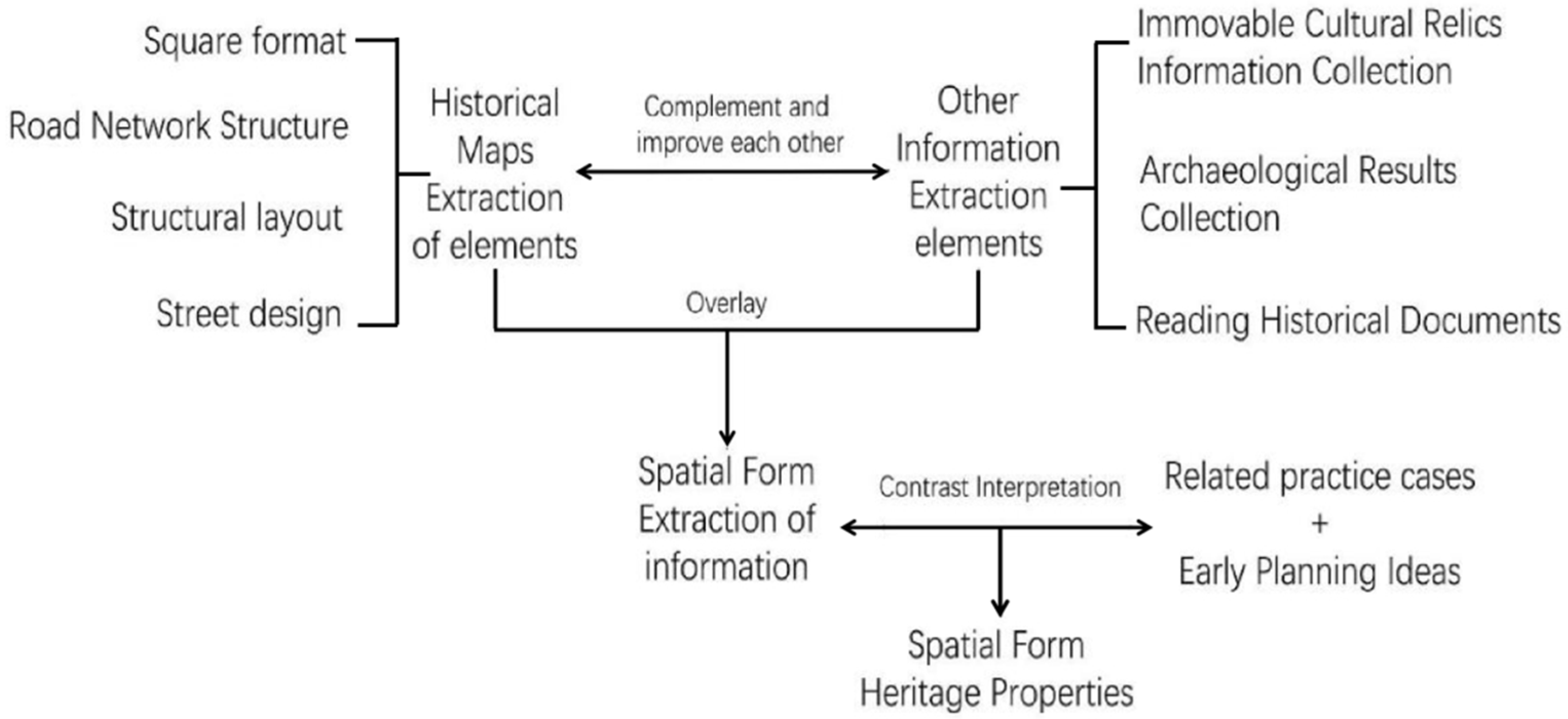
Van et al. [45] discussed the relationship between urban streets and social culture, showing that, on the one hand, the formation of spatial forms is influenced by the culture, similar to the “urban planning ideology”; on the other hand, spatial forms have both practical characteristics and their characteristics depending on the natural and human environments they are located in. Therefore, this study was explored via a case study, comparative analysis, and inductive-deductive methods. Firstly, based on the main body of planning, relevant cases of planning practice in the same period were collected, and their spatial forms and characteristics under the influence of modern Western urban planning ideas were analyzed, including square forms, road network structures, street designs, and structural layouts, by combining relevant information such as immovable cultural relics, archaeological results, and historical documents. Secondly, a comparative analysis was conducted to explore the unity of the spatial forms of different cases and to restore the process and path of spatial forms under the influence of modern Western urban planning ideas in the context of the dissemination of early planning ideas. Finally, the unique spatial forms and characteristics were summarized in the context of the historical information of the construction and planning of this study case, and then its unique heritage attributes were elucidated (see Figure 5).

2.3. Selection of Research Cases

Dalian was chosen as a case study for a couple of reasons. Firstly, among more than 100 railroad towns, Dalian was the first to draw up an urban planning scheme, and it was a pioneer in the planning and construction of railroad towns on the entire line, serving as a model for town planning, as verified in the Letter of the Russian Foreign Minister to Tsar Nicholas II dated 11 November 1897 [46]. Secondly, most of the railway town plans started with the planning of station areas and gradually transitioned to town planning, according to the records of the city construction archives in 1899 [47]. Dalian was considered a large city (with 9 square miles of land, which could accommodate more than 100,000 people) when the city plan was drawn up, and it was a relatively complete case of city planning. Thirdly, Dalian, as a stage for Russian engineers, continued the ideas of tsarist city planning and incorporated modern Western urban planning.
For the selection of comparative cases, first, based on the urban planners, the planning schemes created by Russian engineers were selected to extract the Tsarist Russian urban planning ideas and experiences more accurately; second, based on the characteristics of Dalian city (e.g., coastal city), similar Russian urban planning cases were selected to explain the connotation and characteristics of the Tsarist Russian urban planning ideas more deeply; finally, prominent examples of modern Western urban planning thought (e.g., Paris) were chosen for comparative analysis based on the spatial characteristics of Dalian, which can help clarify the extensive influence of modern Western urban planning thought on the spatial form of Dalian city. Additionally, the Russian State Historical Archives (based in St. Petersburg) provided the majority of the research resources described above, including city construction archives, historical maps, and design drawings.

3. Results

3.1. Chinese Eastern Railway Towns’ Spatial Form: The Influence of Modern Tsarist and European Planning Thought

When Dalian’s first urban master plan was created, it was thought of as a whole organism made up of autonomous neighborhoods surrounding the city center, each with its distinct spatial structure, yet being spatially connected. Due to the widespread usage of spatial design techniques such as “radial, ray-shaped, and diagonal”, “curved” streets are common in urban areas. Additionally, strict adherence to the unity of planning and construction is maintained, and when drafting planning schemes, architects take into account the practical situation (construction). Additionally, it is crucial to thoroughly evaluate the relevance of these spaces in the planning framework, the overall appearance, and the relationship with the surrounding environment when choosing a residential, public, administrative, or another spatial arrangement.
The complexity of the composition provides a way to achieve a unique urban landscape (planning and design development), with a strong focus on the use of topography in plan development and even the development of matching uses or spatial layouts for some unique sites. Based on the notion that “Topography was an influential factor in spatial planning in the ancient Rus period”, a distinctive road network was developed during the process of urban formation in the Far East [48]. The residential structures are dispersed around the green space, including both official private dwellings and other types of neighborhood residences. The small-scale multi-story structures, low building density, and abundant vegetation in Dalian produce cozy places that are essential.
There is little question that Howard’s concept of the “garden city” and the new Russian city are similar since both have created vast parks with public buildings in the middle of Dalian, which are consistent with the idea of the “garden city” and are distinctive features of the new Russian city [49]. A healing town’s central park is comparable to the concept of a “garden city”, and the two appear to share similar ideas in terms of “building and planning” as well as similar content in terms of the local area. Both were conceived as a means of “providing the public with a more pleasant, convenient and beautiful atmosphere to live in an idyllic area, improving the visual and spiritual experience of the occupants, with a heavy focus on personal experience [50]”.
Although it was strategically necessary to build towns along the Chinese Eastern Railway for Tsarist Russia to invade Northeast Asia, the architects in charge of the planning and construction of the towns did not abandon the pursuit of idealism or romanticism and made every effort to create a lovely and peaceful town environment as a way to increase the happiness of the residents.

3.2. The Characteristics of the Tsarist Urban Planning Ideology as It Influenced the Morphology of the Land

3.2.1. Regional Division Method

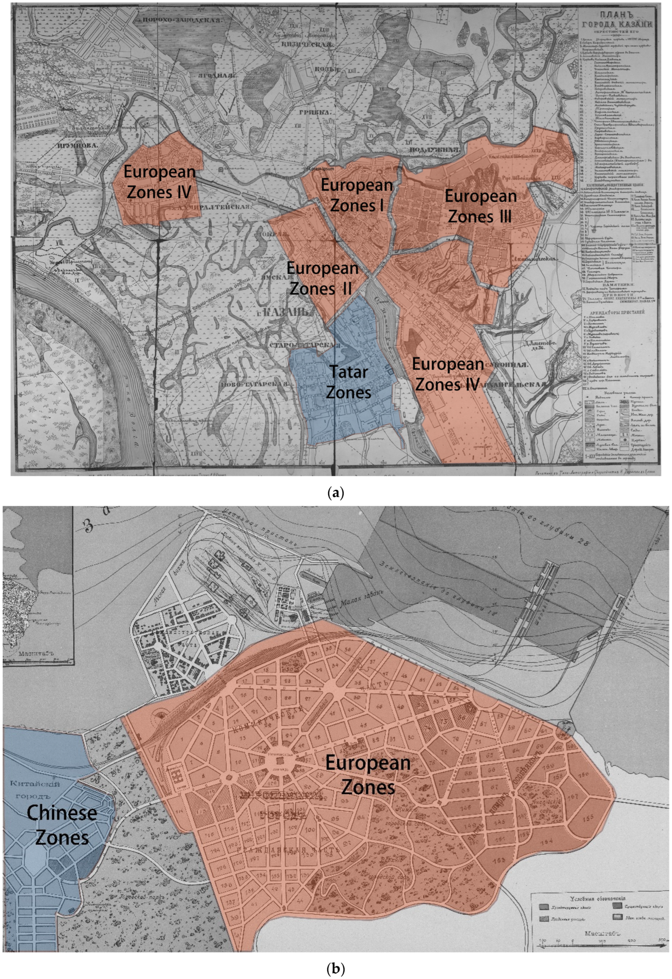
Dalian’s urban spatial organization shows how similar it is to the typical tsarist city type. This covers not only how the territory is divided but also how the space is organized and how the shoreline is built. The city of Dalian is divided into three basic zones that are independent of each other: the Chinese Zones, the European Zones, and the Administrative Zones. A moat “1.2 s.f. wide and 3.5 s.f. deep” separates the European Zones from the Administrative Zones, and a viaduct connects the two [51]. According to their characteristics, the commercial, residential, and villa zones make up the European Zones. The Chinese Zones were created using conventional Chinese planning techniques and are situated in the eastern portion of the European Zones. To be more precise, the entire city is separated into two districts, one of which is planned and developed according to European standards and the other according to traditional Chinese design principles mixed with elements of Russian regional culture. The Kazan city plan of 1887 [52], which separated the city into “Tatar Zones” and “European Zones”, for example, reproduced such a split of the city into zones in the earlier tsarist urban planning practice. There were “administrative districts”, “commercial districts”, “villa districts”, etc., within the “European Zones”. The primary basis for this classification is residential areas. This division is based on the various ethnic characteristics of the settlements and the differentiation of regional functions, which will facilitate the differentiation of different regions (ethnic-specific spatial organization, architectural forms, and regional functions). And in this process, geographical elements such as mountains and rivers naturally become the natural boundaries that divide the region (see Figure 6). But the early urban pattern of Dalian presents a basic structure that is not an exception compared to colonial planning around the world. However, it is relatively unique for modern Chinese cities and is a typical example of an early Chinese urban case in which foreign urban planning ideas were put into action, and its spaces were built intact according to the established plan. At the same time, this urban planning idea was introduced by Russian architects or planners.

3.2.2. Spatial Layout Characteristics

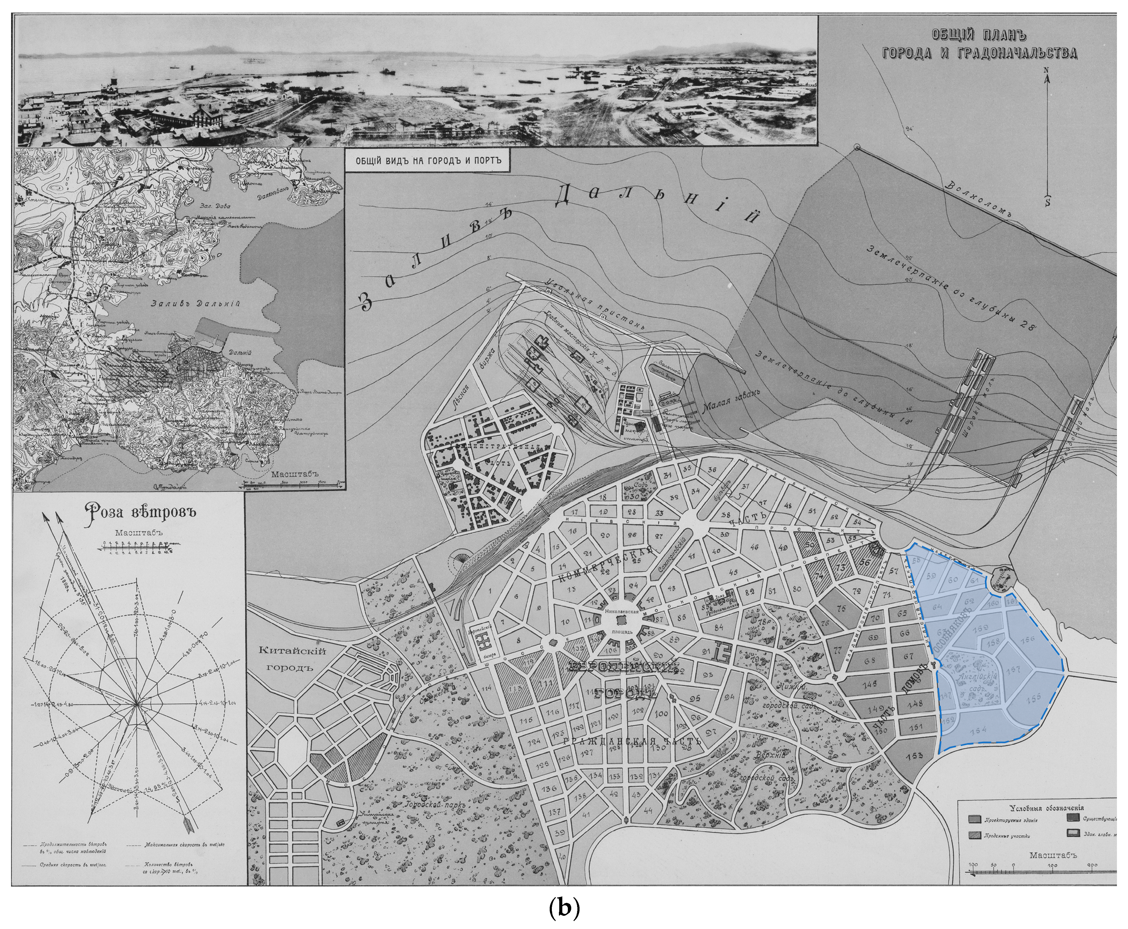
Dalian is situated in a mountainous region with numerous gorges and mountains. To make the most of such a complicated urban structure, the architect planned a variety of urban functions, preserved the complicated landscape of gullies and ravines, built the shortest and most comfortable routes between each area and the port and railway station, fully utilized its potential for spatial utilization, and produced a compact spatial layout. To simplify the development of broad, straight streets with room for the construction of administrative, shop, and bank buildings, for example, along the streets, the commercial area was developed in the plain region that was closest to both the residential area and the villa area. The residential areas in the European Zones, in contrast, are situated in hilly regions far from the mountains, where there are numerous washouts, the streets are frequently short and uneven, and the neighborhoods are divided into small pieces for the staff to build homes. The European villa neighborhood is found in the district’s eastern, undulating area, where there is a 1.2 s.f.long eroded gully. Even though the area is separated into huge plots for the construction of private mansions for the wealthy, the streets are modest and have an overall curved appearance. Numerous (Russian) architects’ design concepts exhibit this common spatial trait, which is commonly present in the design of relatively small urban places. The spatial layout of the Black Sea coastal resort in the Caucasus casts a shadow on Dalian’s urban area. For instance, the 1870s urban design of Gelendzhik [53] has such a compact spatial arrangement that it produces a somewhat enclosed space and is more suited to protecting against wind and moisture in the coastal area as well as improving the capacity for spatial exploitation (see Figure 7).

3.2.3. Typical Beachfront Development

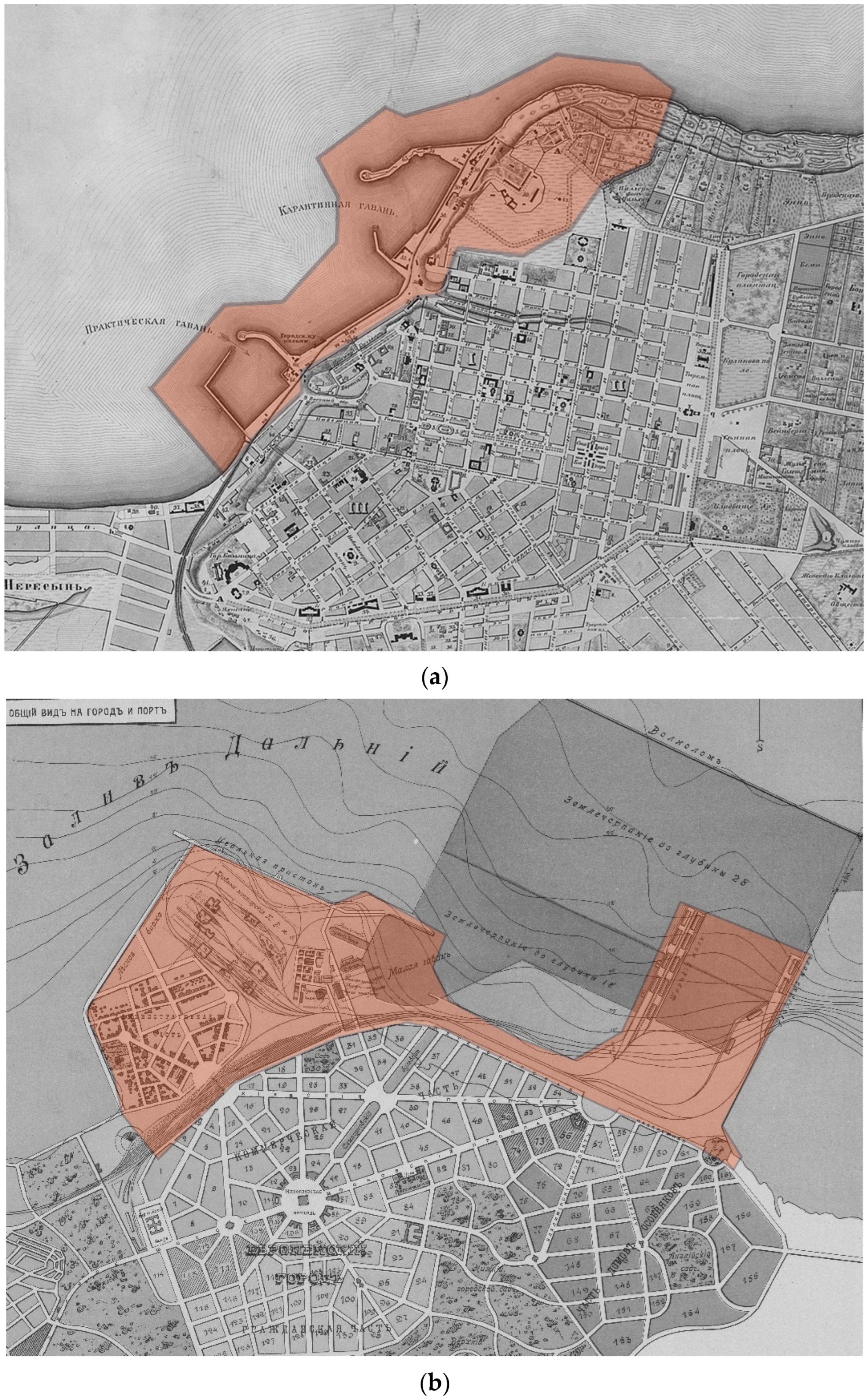
Dalian is bounded to the east by the Yellow Sea, to the west by the Bohai Sea, and to the south by the Shandong Peninsula. The lime brick factory and the pig iron foundry, which provided a significant amount of storage equipment and pipes for the construction of the Manchurian Railroad, were the first industrial buildings to be built in the port because of their advantageous location. The architect also created a beautiful urban landscape with the space near the bay and the railroad line as the area for future industrial construction. In the southern region of the Liaodong Peninsula, villa communities and seaside baths have been built close to the mountains. More importantly, the “St. Petersburg” shore, an open region in the middle of the coastline where people can enjoy stunning views of the sea, has been developed as a public space for amusement and relaxation. In actuality, such a strategy is based on the design of the coastal boulevard in Odessa [54]. In terms of shoreline design, both use a convex dock, which follows the topography well. Meanwhile, the outer side of the convex dock on the eastern side of the shoreline is used as a breakwater to block the waves coming from the east. Furthermore, all low, unwelcoming, or unhealthy areas that negatively impact the quality of life in the European Zone have been converted into gardens, ponds, or landscaped erosion prevention strips, becoming significant landscapes that are “landscaping, recreational, scenic, and symbolic of the city” (see Figure 8).

3.3. Heritage Spatial Form Traits Influenced by European Urban Planning Concepts

3.3.1. Baroque Axis Structure

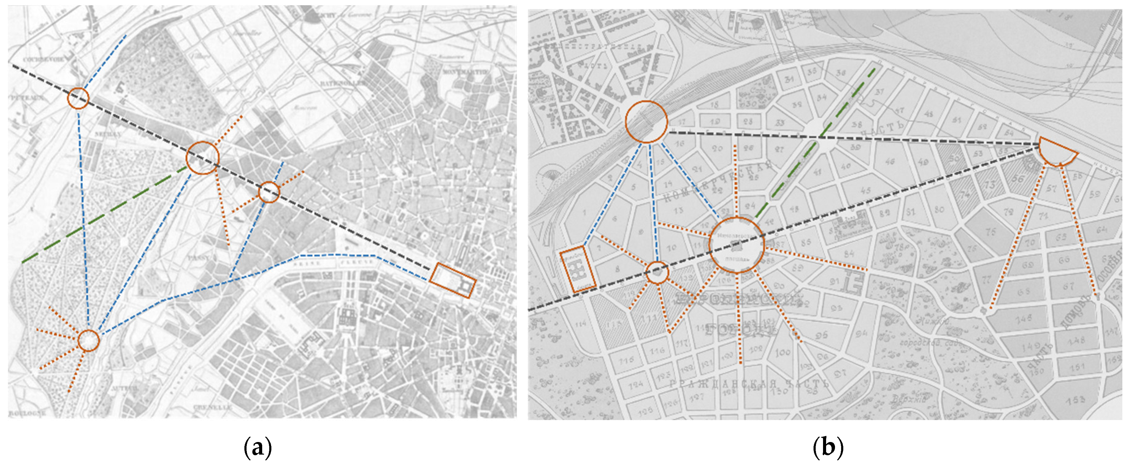
The architect K.G. Skolimovsky distinguished the purposes of the various zones when constructing Dalian’s urban structure and achieved the organic integration of the largest independent zones by creating squares with radial roads in the zones’ cores and connecting the other cores with streets that passed through them. In essence, the polycentric character of the urban form reflects the city’s multipurpose goal. The spatial form of a ray-shaped road network connecting the cores of various locations is a crucial Baroque planning and architectural strategy. A spatial node serves as the basis of the branch road system, which was developed at the start of the Renaissance to connect urban regions with various features. The 1899 Dalian plan is analogous to the Paris transformation example or a shattered recreation of the Ottoman Paris urban plan of the same period [55]. The entire structural design of the metropolitan area shares many similarities with the change in Paris, and this borrowing is not just restricted to Star Square itself (see Figure 9). Such an urban form was quite common in European cities, but it was indeed very rare in China at that time. At the same time, Dalian, as the city where this planning layout was implemented in its entirety, belongs to the typical examples of modern China.

3.3.2. Plaza Type

To visually emphasize the iconic nature of the buildings and improve the spatial guidance of iconic buildings, the architect built the square on higher ground in an area with breathtaking views and surrounded it with public buildings, which are frequently placed on undulating terrain. Public spaces are also scattered fairly evenly across the city to balance the overall expression of the urban landscape. For instance, 11 plazas have been constructed in the European Zones, and they can be categorized into four different types: plazas in front of grand buildings, plazas in front of stations, traffic-oriented plazas, and plazas with street gardens. These squares generally adhere to the design philosophy of traditional Western spatial esthetics and share many similarities with traditional European public squares in terms of shape.
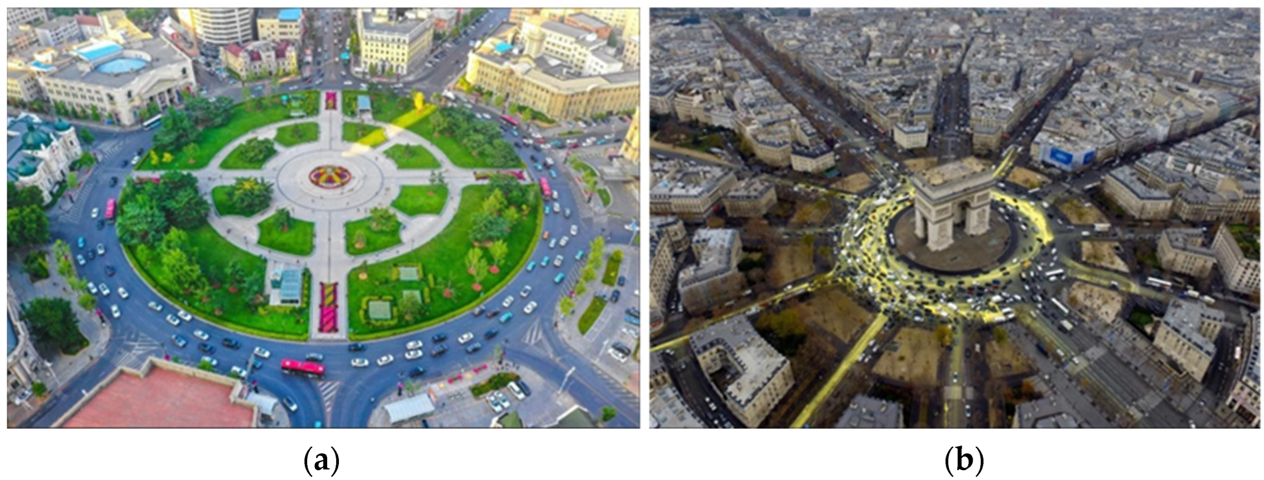
The center of the city is the enormous Nicholas Square, which is situated in the European Zones’ business sector and has the shortest connections to the other parts of the city via ten rayed streets. The court, police administration, and city council buildings are positioned around the church, which is situated in the middle of the square. The City Club, which is situated on Moscow Street in the business center, is widely used as a location for meetings, negotiations, and local business trips. Nicholas Square has a shape similar to the main square of “Paul Zakir’s five types of squares”. The spatial center of gravity of Zakir’s five different types of plazas is in the middle of the space rather than on one side. The layout of the buildings surrounding the plaza is generally balanced, with no particularly notable structures and no overt enclosure of the square by the buildings, which nevertheless serve as locations for people’s activities. Additionally, statues or monuments predominate in the square’s center to command attention. As a result, such a square shows a generally dispersed space and unifies the space via a collection of iconic or guiding aspects, creating a spatial tension to bring the space’s various components together, as in the instance of Place Charles de Gaulle in Paris (see Figure 10).
Numerous more squares that have an impact on the spatial shape have been built in addition to Nicholas Square. Site Square is situated near significant organizations such as the Railway Administration, while Exchange Square and Red Square are situated near vital nodes such as railroad stations and ports. The roadways that connect Kyiv Street to Red Square’s canal shore area run through those two squares. The combination of the large boulevard, the Samson mountains along the ocean, and Samsoniowski Street creates a view that is evocative of the Vesuvius landscape in Naples, Italy. It closely resembles the “dominant square” stated by Paul Zakel, which develops a vision while emphasizing a sense of order. To highlight the city’s significant structures, similar to the instance of Rome’s “Piazza Della Civica”, the plaza is dominated by a core of buildings on one side that are frequently vital transportation centers or administrative institutions of the city.

3.3.3. Design of Street

Dalian is the first example of urban planning in Russia in which the width of streets is divided according to different zones. The city has 1.2 s.f. wide streets, 9 s.f. wide streets and 6 s.f. wide alleys in rough areas, and 42 s.f. wide street Самсoниевский, which leads to the city’s street garden. In actuality, the design of the streets considers both the view from a distance and the view from up close. Examples include the street’s extension from Nicholas Square to the picturesque hills, the lovely interaction between the roadway and the buildings, and the cohesive area of “administrative space–traffic network–Catholic church”. This type of spatial design is a result of “Baroque planning”, which emphasizes the beautiful impact of wide, straight streets on the one hand and the coherence of squares, streets, and buildings on the other. In actuality, the opposing view is frequently placed at the end of the street, and a continuous architectural interface is made on both sides of the street using the same method. In keeping with the typical construction method of tsarist cities, the end of the street is used as the starting point for the construction of the “manor-style” gardens, and the boulevards and paths are laid out in the space leading to the buildings. In the distance, the unique and beautiful landscape and park recreational facilities are visible. The most expressive components of Dalian’s landscape are not by chance found in the city. Additionally, the Russian Orthodox Church has the most attractive location in the area of the city with the highest concentration of private residences. This church was built strictly in the manner of traditional Russian churches from the 19th century, giving the area its most Russian spatial icon.

4. Discussion and Perspectives

4.1. The Primary Legacy of Dalian City Is Contemporary Urban Spatial Form

Dalian is an example of a port-based growing metropolis that was impacted by colonial planning to create a distinctive urban spatial form during the contemporary railroad economic boom. By visiting the Russian State Historical Archives to gather pertinent urban construction archives and extracting pertinent information from a significant amount of Russian materials, this study closes the knowledge gap in the study of the spatial form of Dalian at the early stage of urban construction. Looking back on the process of development, it can be seen that Dalian’s modern urban spatial form emerged during a specific historical development process, was created via the combined action of the political environment, regional development, social economy, and humanistic thought, and has the unique heritage characteristics of a geographical unit (see Table 1). The colonization and railroad economy introduced modern Western planning ideas to Dalian urban space, in contrast to the traditional Chinese spatial form of the Li-Fang unit system and unfettered development, and the spatial forms under their influence frequently embraced the Baroque axis structure. Dalian’s urban planning and residents’ lives also have undergone significant changes as a result of the intensification of capitalism and the transformation of production techniques. These changes have had a significant impact on the evolution of spatial forms and have nurtured heritage traits such as “multiple patchwork, fusion, and openness” that make up the city’s core heritage.

4.2. Spatial Forms Document the Transformation of China’s Modern Urban Development

Dalian has recently actively reacted to the central government’s resolve to improve “historical and cultural preservation and inheritance” and energetically carried out urban heritage conservation methods. Dalian is a well-known historical and cultural city in China. However, conservation strategies, research on the status quo, and value assessments make up the majority of conservation practices and related studies [58,59,60,61], which rarely explore the implications of Dalian’s urban heritage composition and ignore the significant value and unique significance of spatial forms. When looking back at the history of Chinese cities, it can be seen that the feudal system, which was characterized by a natural economy and small-scale trade as the major mode of urban development, limited the early urban construction and left out broad urban planning concepts and design layouts. Following the Opium War, colonialists imported modern Western urban planning concepts and began urban construction, planning, and transformation, creating successive modern railway-style, industrial, and commercial urban development models that incorporated zoning construction in urban areas. Urban space started to transition from “slow and active” spontaneous evolution to “quick and passive” integration and renewal under the influence of colonial planning concepts. This trend promoted the adoption and disintegration of Western urban planning concepts in China. A significant physical example of the aforementioned planning concepts is the spatial form of Dalian city, which has been kept to this day. This form maps the heritage value of modern Western urban planning concepts. In addition, Dalian’s modern urban landscape and colonial remnants have gradually grown and taken root on Chinese soil after decades or even centuries of colonial rule and development, creating a distinctive East-meets-West history.

4.3. Spatial Form Is an Important Medium for Preserving the History of Urban Development

The conflict between urban modernity and historical and cultural heritage is becoming more and more evident as cities continue to grow, seriously and badly affecting historical space and the buildings that are related to it. Dalian’s current urban spatial form is a significant repository of the history of urban development and serves as a vital link between the past and present [62]. It makes sense to enhance awareness of the importance of spatial form and recognize that it has heritage qualities under the combined influence of old city rehabilitation and historical preservation. In contrast to other periods in Chinese history, modern China was in the midst of a period of significant internal and foreign change, during which colonial and local cultures frequently clashed and interacted, resulting in a distinctive pattern of urban growth. The “square + radial road network” that symbolizes Dalian’s spatial form is a result of contemporary Western planning theory. It exhibits high density, large scale, and multi-functional spatial characteristics that meet the needs of production and daily life at the time. The resulting sense of spatial belonging and era has been preserved to this day and is a singular memory of modern Chinese urban development history. A unique recollection of modern Chinese urban development history, the ensuing feeling of place and time has been preserved to this day. Such a space is the result of how urban forms developed and came together throughout the colonial era when various architectural styles coexisted and a distinct way of life developed (see Table 2). In other words, the urban area of modern China had to accommodate the production and habitation needs of the local populace as well as the living and cultural requirements of the Western colonial powers. As a result, a space with a diverse cultural character and a special heritage memory was produced.

5. Conclusions

This paper makes the case that both Tsarist Russian and Western modern urban planning concepts had an impact on the contemporary urban environment of Dalian. To design Dalian’s urban transportation and create a hierarchical road system, Russian architect K.G. Skolimovsky employed the Baroque planning concept. He did this by drawing on the knowledge of Parisian urban planning. At the same time, the city’s topographic features are enhanced by placing squares on higher ground, arranging radial roads around them, and connecting the squares with straight roads to form a multi-layered ring road with the square as its core. In terms of neighborhoods, the city’s roads are primarily radial, interlocking with one another to form numerous irregular wedge-shaped plots, which are influenced by the Baroque pattern. The circular roadways also cut across these plots, creating a variety of tiny polygonal plots that barely all have the same shape. In addition, under the influence of the aforementioned urban spatial layout, the urban street outline is relatively small, and the typical street outline depth of the commercial area is 80–120 m. In terms of public buildings, the architects draw from the classical design concept and arrange a significant number of public buildings (such as businesses, hospitals, places of worship, etc.) around the city square to better direct and dominate the urban space. Buildings in the classical, eclectic, and neoclassical styles were constructed at the same time under the influence of modern architectural thought. In terms of public open space, the architects incorporated the idea of garden city planning and the knowledge of tsarist city planning and paid attention to the creation of urban landscape greenery, leaving wide green areas on both sides of the roads. At the same time, city parks and boulevards are constructed using the topography and forestry of the surrounding area, such as the shoreline scenery where locals and visitors can take in the picturesque view of the pier.
Today, more than a hundred years later, the modern urban space of Dalian has developed into a dominant central area in the modern city, and Nicholas Square (now Zhongshan Square) is the core of the whole of Dalian, surrounded by historical buildings used by government departments and large enterprises, with strong advantages in commerce, finance, and offices, and still has a strong environmental atmosphere and landscape appearance of the Western colonial city, with Zhongshan Square as the core. The resident population of Dalian’s old city has exceeded 5 million [63]. This study examined the formation process of urban spatial form in modern Dalian from the perspective of urban planning ideas, and the main contributions are as follows: first, a search for relevant materials in the Russian State Historical Archives was conducted to make up for the lack of archival materials on urban construction in modern Dalian; second, a comprehensive survey of the history of urban planning in modern Dalian was conducted to restore the formation process of urban spatial form in modern Dalian; third, in conjunction with the dissemination of urban planning, the heritage attributes of the urban spatial form of modern Dalian were discussed in the context of the dissemination of urban planning ideas. In addition, this paper, as a fundamental study of modern Dalian urban space, provides support and a basis for the historical continuity, heritage protection, and spatial renewal of Dalian city.
Dalian’s modern urban space is the result of the development of a specific period, which was influenced by the socio-economic level, the spread of humanistic ideas, and the geographical and environmental conditions of this period, and its urban space form contains many reasonable factors. On the other hand, Dalian’s modern urban space has evolved into the core area of the city and still maintains its dominant role and status. Therefore, for the future renewal and transformation of the area, it is important to understand its spatial form formed in a specific period to guide the development of future urban space.

Author Contributions

Conceptualization, B.Z., and Q.W.; methodology, B.Z.; writing—original draft preparation, B.Z.; writing—review and editing, Q.W.; project administration, B.Z. All authors have read and agreed to the published version of the manuscript.

Funding

The third phase project of the superior discipline construction project of Jiangsu universities and the «14th Five-Year Plan» Jiangsu Province key (cultivation) discipline funding. Study on construction and planning of railway town in Manchuria (Helongjiang Federation of Social Sciences, No. 22323).

Institutional Review Board Statement

Not applicable.

Informed Consent Statement

Not applicable.

Data Availability Statement

Not applicable.

Conflicts of Interest

The authors declare no conflict of interest.

References

  1. Weaver, T.P.R. Charting Change in the City: Urban Political Orders and Urban Political Development. Urban Aff. Rev. 2022, 2, 319–355. [Google Scholar] [CrossRef]
  2. Yang, Y.C.; Zhang, Y.K.; Huang, S. Urban Agriculture Oriented Community Planning and Spatial Modeling in Chinese Cities. Sustainability 2020, 12, 8735. [Google Scholar] [CrossRef]
  3. Lin, R.J.V. Eastward Expansion of Western Learning: A study of Westernisation of China’s modern education by Chinese government overseas-study scholarships. Educ. Philos. Theory 2016, 12, 1203–1217. [Google Scholar] [CrossRef]
  4. Feng, Z.T.; Wang, X.H.; Xiang, X.W. The Study on the Living Function of Lane Block—Guided by Alleviating the Issue of “Defamiliarization” in the First and Second Tier Urban Residential Areas. Chin. Overseas Archit. 2020, 8, 86–89. [Google Scholar]
  5. Liu, G. Reflection on Shanghai Shikumen Lilong Rehabilitation. Herit. Archit. 2016, 4, 1–11. [Google Scholar]
  6. Nie, L.F. Research on the Overall Layout and Road Network Form of Linong Building in Nanjing during the Period of Repubilc of China. Chin. Overseas Archit. 2018, 11, 86–88. [Google Scholar]
  7. Zhou, X.; Kubota, A. Between Family and State: Discussion on the Segmentation and Unification of Daily Living Space within Shanghai Historic Lane Neighborhood. Landsc. Archit. 2018, 4, 34–40. [Google Scholar]
  8. Fan, W. The development and changes of Shanghai linong: The example of Deqingli, Rongkangli and Zhenxingli. Constr. Mater. Decor. 2019, 17, 65–66. [Google Scholar]
  9. Master Plan of Shanghai in 1904. Available online: https://www.virtualshanghai.net/Asset/Preview/vcMap_ID-76_No-1.jpeg (accessed on 13 September 2022).
  10. Aoki, N.; Wang, R.R.; Xu, S.B. Production and Evolution of Everyday Space in Modern Concession Cities: A Case Study of the Leisure Space in the Former British Concession in Tianjin. Time Archit. 2021, 5, 24–31. [Google Scholar]
  11. Chen, G.D.; Aoki, N.B.; Xu, S.B. The Beginning of East Asian Modern Cities: Comparative Study on Colonial Planning and Management of British Concessions and Settlements. Architect 2019, 3, 51–69. [Google Scholar]
  12. Chen, Y.L. A Study of the Urban Infrastructure of the Japanese Concession in Tianjin. China Anc. City 2020, 4, 66–75. [Google Scholar]
  13. Geng, M.Y.; Hong, L.; Ma, K.X.; Wang, K. Evolution of Urban Public Space Landscape in Tianjin Port City. J. Coast. Res. 2020, 104, 142–146. [Google Scholar] [CrossRef]
  14. Map of Tianjin City Road Network in the Early 19th Century. Available online: https://paris1814.com/wp-content/uploads/plan1t-1536x937.jpg (accessed on 13 September 2022).
  15. Law, A.M.; Qin, Q.Q. Searching for Economic and Cosmopolitan Roots: The Historical Discourse of “Hankou Merchant Port Nostalgia” in the Central Chinese City of Wuhan(SIC). Metu J. Fac. Archit. 2018, 2, 173–195. [Google Scholar]
  16. Zhang, T.J.; Li, B.H.; Li, Z. Dong Xiujia and City Planning in Modern Wuhan. New Archit. 2012, 3, 138–143. [Google Scholar]
  17. Plan of the Hankou Area of Wuhan in the Early 19th century. Available online: http://tehne.com/assets/i/upload/event/T11-Arhitektura-kapitalisticheskikh-stran-XX-v-1973-0780.png (accessed on 13 September 2022).
  18. Steinmetz, G. The colonial state as a social field: Ethnographic capital and native policy in the German overseas empire before 1914. Am. Sociol. Rev. 2008, 4, 589–612. [Google Scholar] [CrossRef] [Green Version]
  19. Coco, O. German Imperialism in China: The Leasehold of Kiaochow Bay (1897–1914). Chin. Hist. Rev. 2019, 2, 156–174. [Google Scholar] [CrossRef]
  20. Becker, J.L. ‘To Grab, When the Grabbing Begins’ German Foreign and Colonial Policy during the Sino-Japanese War of 1894/95 and the Triple Intervention of 1895. Int. Hist. Rev. 2021, 1, 1–20. [Google Scholar] [CrossRef]
  21. Master Plan of Qingdao in 1924. Available online: https://www.geographicus.com/mm5/graphics/00000001/L/TsingTau-japgovtrail-1924.jpg (accessed on 13 September 2022).
  22. Zhang, B.C.; Zhao, Z.Q.; Sun, Y.Z.; Khodakovsky, E.V. Study on the Town Planning Model of Chinese Modern Railway Stations—Taking the Second-Class Stations of the Chinese Eastern Railway as an Example. Bylye Gody 2020, 1, 272–286. [Google Scholar]
  23. Zhang, B.C.; Zhao, Z.Q.; Sun, Y.Z. Urban planning and construction of Harbin in 1898–1903. Vopr. Istor. 2020, 7, 206–214. [Google Scholar]
  24. Zhang, B.C.; Wang, Q.L.; Zhao, Z.Q.; Dong, Y.; Dong, W. Research on urbanization under the influence of regional war (on the example of Harbin city). Vopr. Istor. 2022, 1, 166–175. [Google Scholar]
  25. Obertreis, J.; Malinova-Tziafeta, O. Urban History and Water Infrastructures in the Russian Empire and the Soviet Union. Mod. Hist. Russ. 2020, 1, 173–201. [Google Scholar]
  26. Agafonova, A.B. Water Supply to the Small Cities in the Northern Region o the Russian Empire, 1890–1910s (Vologda, Staraya Russa and Cherepovets). Mesto A Dej.—City Hist. 2020, 1, 45–68. [Google Scholar] [CrossRef]
  27. Russian National Historical Archives. China Eastern Railway Administration; Volume 1, No. 716, p. 1.
  28. Russian National Historical Archives. China Eastern Railway Administration; Volume 1, No. 21, pp. 1–2.
  29. Wang, Q.L.; Zhang, B.C.; Li, P.L.; Yi, X.X.; Xu, H.P. Exploration of the cognitive model of urban history in a theoretical perspective. Vopr. Istor. 2022, 1, 210–217. [Google Scholar]
  30. Samoilov, H.A. Russian plans for organizing the management of the city of Dalian in the 19th and 20th centuries. J. St. Petersburg State Univ. 2008, 4, 144–150. [Google Scholar]
  31. Corchagina, O.A. A garden city in the east at the beginning of the 20th century. Curr. Probl. Art Theory Hist. 2016, 6, 668–675. [Google Scholar] [CrossRef]
  32. Shen, Y. A Brief Discussion on the Emergence of Modern Dalian City. Hist. Res. Teach. 1992, 1, 12–14+4. [Google Scholar]
  33. Jiang, L.T. Colonial residential building of Dalian. J. Shenyang Jianzhu Univ. (Nat. Sci.) 1999, 2, 100–105. [Google Scholar]
  34. Shen, Y. A Comparative Study of Modern Dalian and Chinese and Foreign Cities. J. Liaoning Univ. (Philos. Soc. Sci. Ed.) 1993, 5, 44–47. [Google Scholar]
  35. Liu, Q.; Li, S.F. Property Division Characteristics and Its Illumination in Modern Urban Planning in Dalian. Planners 2008, 6, 75–78. [Google Scholar]
  36. Liu, J. Study on the Evaluation System of Modern Architectural Heritage Value in Lushun Taiyanggou. Master’s Thesis, Dalian University of Technology, Dalian, China, 2022. [Google Scholar]
  37. Wang, C.M.; Dan, Q.R. Urban characteristics shaping and building protection and reuse in Dalian. J. Jilin Jianzhu Univ. 2020, 4, 76–80. [Google Scholar]
  38. Wang, Q.M. Research On the Characteristics of Dalian’s Urban ‘Transportation Development in Modern’ Tines. Master’s Thesis, Liaoning Normal University, Dalian, China, 2019. [Google Scholar]
  39. Zhang, D. Study on the Construction, Transition and Landscape Characteristics of Laodong Park of Dalian in Modern Times. Decorate 2022, 10, 124–126. [Google Scholar]
  40. Jing, H.L.; Wang, F.J. Urban characteristics of Dalian during the modern Russian invasion. Hist. Res. Teach. 2010, 4, 95–99. [Google Scholar]
  41. Fan, W.B. Analysis of modern urban planning in Dalian. Shanxi Archit. 2015, 15, 5–6. [Google Scholar]
  42. Jing, H.L. An Examination of the Causes of Dalian’s Urban Development and Cultural Transformation in Modern Times. Knowledge 2015, 6, 90–94. [Google Scholar]
  43. Russian National Historical Archives. China Eastern Railway Administration; Volume 28, No. 104, p. 1.
  44. Dhanani, A. Suburban built form and street network development in London, 1880–2013: An application of quantitative historical methods. Hist. Methods 2016, 4, 230–243. [Google Scholar] [CrossRef] [Green Version]
  45. Xu, Y.B.; Rollo, J.; Jones, D.S.; Esteban, Y.; Tong, H.; Mu, Q.P. Towards Sustainable Heritage Tourism: A Space Syntax-Based Analysis Method to Improve Tourists’ Spatial Cognition in Chinese Historic Districts. Buildings 2020, 2, 29. [Google Scholar] [CrossRef] [Green Version]
  46. Lilley, K.; Lloyd, C.; Trick, S.; Graham, C. Mapping and analysing medieval built form using GPS and GIS. Urban Morphol. 2005, 1, 5–15. [Google Scholar] [CrossRef]
  47. Gorbenkova, E.; Shcherbina, E. Historical-Genetic Features in Rural Settlement System: A Case Study from Mogilev District (Mogilev Oblast, Belarus). Land 2020, 5, 165. [Google Scholar] [CrossRef]
  48. Yang, B.D. A Study on the the Modernization Course of Chinese Modern City. Huazhong Archit. 2010, 9, 5–8. [Google Scholar]
  49. Yan, J.H.; Wan, Y.C. Literature review of urban planning in the period of Dalian from Russia and Japan colonization. J. Dalian Univ. 2016, 5, 6–10. [Google Scholar]
  50. Lin, L. Research on the Composition Model of Dalian Urban Color Image. Ph.D. Thesis, Dalian University of Technology, Dalian, China, 2020. [Google Scholar]
  51. Li, T.X. Research of The Urban Cultural Characteristics of Dalian During the Russian and Japanese Colonial Days. Master’s Thesis, Liaoning Normal University, Dalian, China, 2015. [Google Scholar]
  52. Russian National Historical Archives. China Eastern Railway Administration; Volume 1, No. 127, p. 11.
  53. Russian National Historical Archives. China Eastern Railway Administration; Volume 1, No. 32, p. 1.
  54. Russian National Historical Archives. China Eastern Railway Administration; Volume 1, No 1164, pp. 1–2.
  55. Liu, Q. The Study on the Urban Form of the Modern City Planning in Northeastern China. Master’s Thesis, Dalian University of Technology, Dalian, China, 2008. [Google Scholar]
  56. People’s Daily, China on Twitter. Available online: https://pbs.twimg.com/media/D-ho79tW4AEVjeT.jpg:large (accessed on 23 July 2022).
  57. Place Charles de Gaulle in Paris. Available online: https://timetraveling.ru/images/to_site/na_zametku/piazza-st-petra.jpg (accessed on 13 September 2022).
  58. Wu, Y.H.; Li, L.; Xiao, Y. Research on the Protection Strategy of Historic Districts Based on Urban Spatial Structure—A Case of Dalian. Urban. Archit. 2021, 18, 96–98. [Google Scholar]
  59. Yu, N.; Cui, Y. Protection and Reuse of Historical Buildings in Dalian: Taking the Restoration of Zhoushuizi Old Railway Station as an Example. Archit. Tech. 2020, 26, 112–115. [Google Scholar]
  60. Wang, S.Y.; Liu, P.P.; Xu, W.X.; Liu, J.J. Study on the Value Evaluation of Modern Historic Buildings—A Case of Zhongshan District in Dalian. Urban. Archit. 2020, 17, 170–174. [Google Scholar]
  61. Hu, W.H.; Wang, S.; Zhao, C. Place-making and Micro-renewal Conservation in Urban Historic Districts: The Case of Dong Guan Street in Dalian. China Anc. City 2018, 1, 64–68. [Google Scholar]
  62. Birer, E.; Adem, P.C. Role of public space design on the perception of historical environment: A pilot study in Amasya. Front. Archit. Res. 2022, 11, 13–30. [Google Scholar] [CrossRef]
  63. Dalian Statistical Yearbook. Available online: https://data.cnki.net/yearbook/Single/N2022070138 (accessed on 20 December 2022).
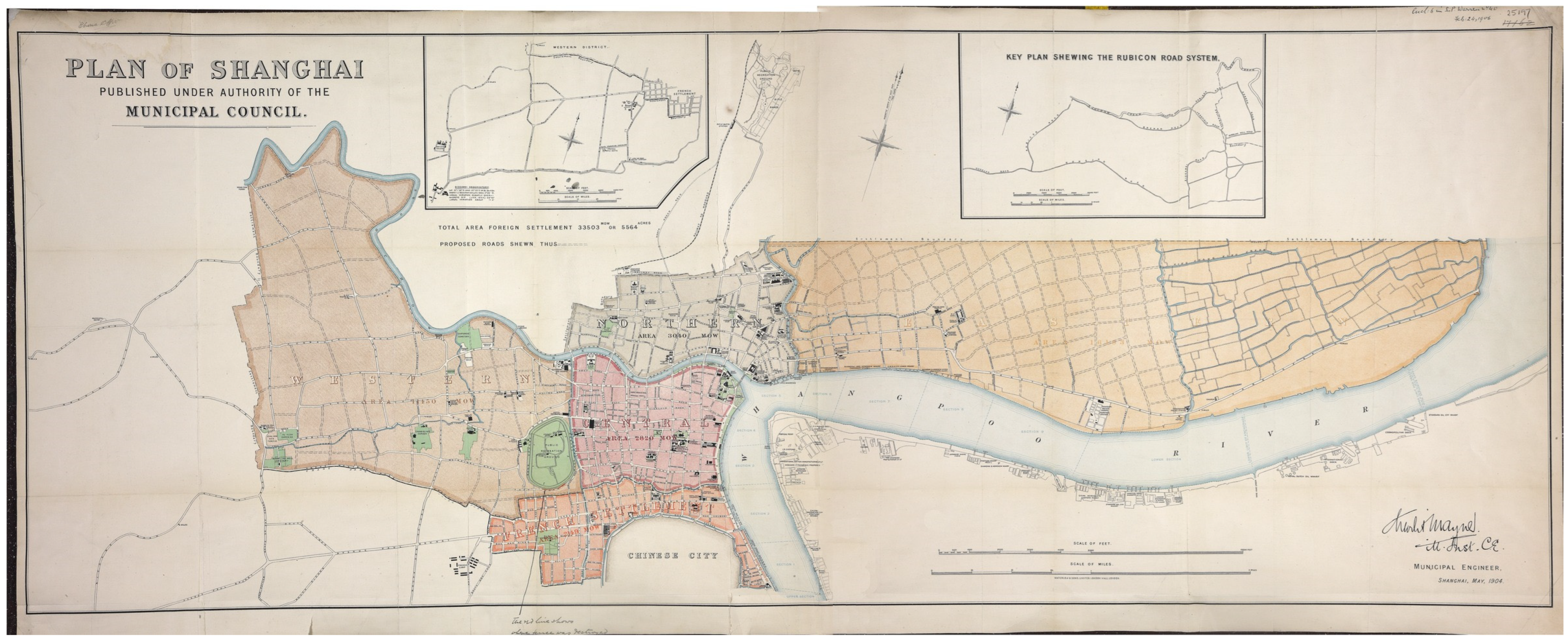
Figure 1. Master plan of Shanghai in 1904 [9].
Sustainability 15 10899 g001
Figure 2. Map of Tianjin city road network in the early 19th century [14].
Sustainability 15 10899 g002
Figure 3. Plan of the Hankou area of Wuhan in the early 19th century [17].
Sustainability 15 10899 g003
Figure 4. Master plan of Qingdao in 1924 [21].
Sustainability 15 10899 g004
Figure 5. Technical route of spatial morphological heritage attribute analysis.
Sustainability 15 10899 g005
Figure 6. Regional division based on ethnic affiliation: (a) Kazan master plan (1887)—learning from regional division models; (b) the unique zoning of the Dalian master plan (1899).
Sustainability 15 10899 g006
Figure 7. Construction of shoreline with emphasis on scenery creation and rest for people: (a) Gelendzhik master plan (1870s)—learning from a compact spatial layout; (b) Dalian master plan (1899)—compact spatial layout. (The blue area shows the compact space layout).
Sustainability 15 10899 g007aSustainability 15 10899 g007b
Figure 8. Spatial layout for climate adaptation and potential enhancement: (a) Odessa master plan (1892)—learning from shoreline construction; (b) Dalian master plan (1899)—typical coastline construction. (The red area shows the coastline construction).
Sustainability 15 10899 g008
Figure 9. The “Baroque axis structure” in Dalian: (a) Paris city structure; (b) Dalian city structure.
Sustainability 15 10899 g009
Figure 10. Iconic plaza that leads to the convergence of spatial elements: (a) Nicholas Square (now Zhongshan Square) in Dalian; (b) Place Charles de Gaulle in Paris [56,57].
Sustainability 15 10899 g010
Table 1. Evolution of Dalian urban planning in modern times.
Colonial CountriesPresents PeriodsEstablished TimeProgram Name/Planning RegulationsDesign Purposes/OutcomesFormulatorRemark
Tsarist Russia1898–1904
Laying the foundation of modern urban space form
1899Dalian Commercial Port Regional Planning (not implemented)Adopt a checkerboard road system with a focus on port construction to create a commercial trade portSakharov
(Mayor and Chief Engineer of Dalian)
Forced to abandon because of the difficulty of construction
1899Dalian Master Urban PlanAdopt a Baroque road system, focus on the relationship between port and city, and build a livable port cityK.G. Skolimovsky
(Chinese Eastern Railway Architect)
Laying the basic contours of urban space
1900Dalian Master City Plan (Revised Edition)Classify road classes and refine the road networkDeepening the planning content of the European region
1901Dalian Master City Plan (Revised Edition)Additional train station, commercial land, and garden green space-
1903Dalian Master City Plan (Revised Edition)Control the number of train stations and churches-
1904Dalian Master Urban Plan (Final Version)Planning a Baroque road system for the Chinese regionBaroque space becomes the target of urban construction
Japanese Government1905–1931
Gradual construction of modern urban space form
1905Dalian special management area set rulesContinuation of the master urban plan of Dalian during the Tsarist periodMitsuhide Kamio
(Director of Dalian Military Administration)
Japan’s first city street planning regulations in Dalian
Dalian City residential building management temporary rulesDevelopment of temporary and permanent building construction rules to promote urban construction in DalianRyozo Kuratsuka;
Matsuyun Maeda
(Japanese engineer)
Improve inner city construction
1911Xiaogangzi Regional Planning
Lijiatun Regional Planning
Promoting urban expansion to the west and developing residential space for the Japanese diasporaCivil Engineering Division, Kanto Governor’s Office, Japan-
1913Shahekou Regional PlanningPromote urban expansion to the east and develop industrial area constructionCivil Engineering Division, Kanto Governor’s Office, Japan-
1919Dalian Master Urban PlanExpansion of downtown area, city center planned to move westDalian Metropolitan Planning Commission (set up by the Kanto Agency of Japan)-
By 1931, Japan had realized the urban planning vision of the Tsarist period while expanding the original city area.
Table 2. Influence of modern Dalian urban culture and its significance.
Different AspectsThe Historical Environment in Which Modern Dalian Urban Culture Emerged (Heritage)Significance
HousingThe architectural form is expressed as a concentrated composition with coarse scale, solid and thick shape, rich architectural outline, and gorgeous skyline generated by the dome, spire, and steep slope roof. This is the distinctive style of the modern building complex.These international architectural traditions and styles introduced classical and eclectic architectural designs, resulting in the distinctive modern Dalian architectural style, which is the city of Dalian’s unique historical architectural legacy.
TransportationBaroque road network structure: with Nicholas Square (now Zhongshan Square) as the center, then streets radiating outward to the surrounding area. These streets radiate to the surrounding area with a number of arterial roads and connect each center, forming the main traffic corridor. Finally, each center is connected with multiple loops and radial roads outward, forming a spider web road structure.To provide favorable travel circumstances and ensure flexible and convenient urban transportation, modern Dalian transportation organically mixes natural landscapes with urban buildings. It still contributes to contemporary urban mobility.
Utilities (water/sewage)The first urban water supply facility was built, along with a 15,000 m water pipeline network and an average daily water supply of 1000 cubic meters. The majority of households must receive water from the water distribution station on their own, and the drainage typically uses the geography and terrain to drop into the intended pond or discharge naturally. Just a few of the officials’ homes have running water for bathing and flushing the toilets.It has fostered Dalian city’s modernization, documented the evolution of Dalian city’s past, and significantly enhanced the current state of the city’s public utilities.
Public Space (parks/greenways/public recreation)1. Green spaces and parks: North Park, now known as Beihai Park, was the first urban park to be created. Additional parks, like West Park, Upper Park, and Lower Park, were made by changing areas like the green barrier, hills, cemeteries, and erosion ditches. To add more green space, the reserved development property on both sides of the city road was changed at the same time.
2. Public recreation: Western views of life and foreign expatriates introduced new pastimes like horse racing, dance, ice skating, tennis, billiards, golf, and movie watching. Drama and other forms of entertainment are appearing at the same time that traditional entertainment is trying to get better.
The physical surroundings and social life of the modern city of Dalian have produced distinctive public spaces, and these components (parks and green spaces, etc.) echo one another, reflecting the characteristics of the contemporary urban landscape and acting as physical representatives of the mood and personality of the contemporary city.
Disclaimer/Publisher’s Note: The statements, opinions and data contained in all publications are solely those of the individual author(s) and contributor(s) and not of MDPI and/or the editor(s). MDPI and/or the editor(s) disclaim responsibility for any injury to people or property resulting from any ideas, methods, instructions or products referred to in the content.