Article

Comprehensive Ecological Planning and Evaluation of Towns from the Perspective of Sustainable Development

1
College of Literature, Tonghua Normal University, Tonghua 134000, China
2
College of Physical Education, Jilin University, Changchun 130012, China
3
School of Civil Engineering, Shaoxing University, Shaoxing 312000, China
*
Authors to whom correspondence should be addressed.
Sustainability 2023, 15(14), 11153; https://doi.org/10.3390/su151411153
Submission received: 8 June 2023 / Revised: 5 July 2023 / Accepted: 11 July 2023 / Published: 17 July 2023

Abstract

:
On 22 December 2000, the State Council of China officially released the National Outline for Ecological and Environmental Protection. In order to further implement the concept of the Outline, the State Environmental Protection Administration of China proposed to comprehensively promote the creation of ecological demonstration areas. As the most basic independent administrative unit in China, township administrative regions are a key bridge connecting cities and rural areas. The comprehensive ecological planning of townships is an important means to promote rural urbanization and promote rural environmental protection work. It is also a concrete manifestation of the scientific development concept and sustainable development (SD) concept in rural work. The research focused on Yuntai Town, Changshou District, Chongqing as the research object and analyzed the physical geography information and socio-economic situation of Yuntai Town. Then, based on the reference of previous achievements, a comprehensive ecological environment evaluation index system was constructed, and an analytic hierarchy process (AHP) was used to evaluate the evaluation indicators. In order to improve the objectivity of AHP, a fuzzy analysis method was used in the experiment to improve the process. On the basis of studying the actual situation of Yuntai Town and based on the established evaluation index system, this study offers targeted suggestions for the deficiencies in the comprehensive ecological planning of Yuntai Town. The establishment of a comprehensive ecological planning and evaluation index system in Yuntai Town has theoretical and practical significance for the SD of the town.

1. Introduction

Urban development is an important means of developing the national economy. In the process of urbanization, township development is related to urban development in China [1,2]. Under the sustainable development (SD) concept, comprehensive ecological planning and evaluation of townships have become an important reference for township development [3,4]. Although the existing evaluation index system can also measure the development level of townships, the differentiated townships development is an important influencing factor related to their SD [5,6]. Therefore, it is also necessary to develop a more appropriate comprehensive ecological planning system from the actual perspective of each township [7,8,9]. Additionally, corresponding comprehensive evaluations are conducted based on one’s own development conditions and level. This is conducive to promoting the comprehensive development of townships, promoting environmental protection work in townships, and improving the economic development level of townships [10,11]. These development changes can further promote the implementation of comprehensive development policies and improve township development [12,13]. When conducting comprehensive ecological planning and evaluation of townships, an analytic hierarchy process (AHP) is often used to construct indicators. AHP can perform qualitative and quantitative analyses on indicators, and has a higher quantification in practical applications. However, when AHP selects too many indicators, it can make it difficult for relevant statistical data to determine the weight value [14]. Fuzzy AHP is a method established on the basis of AHP that improves the objectivity of weights in indicator system development [15,16]. Fuzzy AHP can improve the overall objectivity of the evaluation index system. Researchers have proposed using fuzzy AHP to construct an evaluation index system based on expert opinions [17]. They evaluate the risks they face and their ability to handle disasters based on AHP and triangular fuzzy numbers. Additionally, support vector machine technology was utilized to improve the method for flood prevention and control [18]. When carrying out comprehensive ecological planning for townships, AHP can be used to construct the indicator system. Further, to improve the objectivity of this method, fuzzy AHP can be introduced to improve the method. Yuntai Town is one of the important township administrative regions in China. It is a necessary path for the northeast region of Chongqing to enter the main urban area of Chongqing, and it has high geographical importance. At the same time, this town is a demonstration town for small town development in Chongqing, and its economic functions can radiate to several surrounding towns. Its development and planning have important reference significance for the development and planning of other regions. Therefore, Yuntai Town was selected as the research object in this study. However, in the development research of other townships, attention should be paid to making corresponding adjustments based on local actual conditions. Therefore, in this study, taking Yuntai Town in Chongqing as an example, an improved AHP method was used to establish a comprehensive development evaluation index system for Yuntai Town. It is hoped to promote the SD of Yuntai Town through specific analysis of its comprehensive planning indicators.

2. Basic Information of Yuntai Town

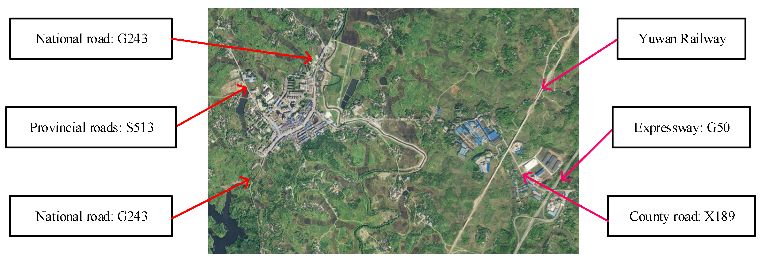
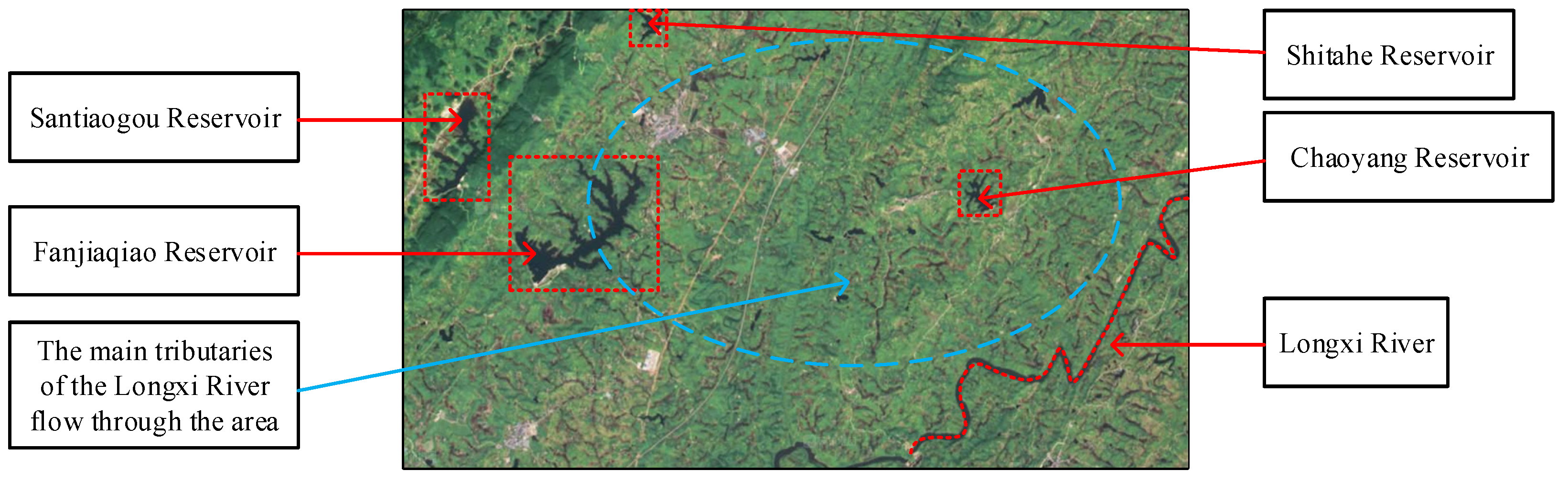
2.1. Overview of Physical Geography of Yuntai Town

Yuntai Town was under the jurisdiction of Yuntai Village during the Ming Dynasty. It was originally Yuntai Township and was renamed Yuntai Town in 2002. It belongs to Changshou District in Chongqing, located at the border between Chongqing and Sichuan Province. Yuntai Town has one community and 13 administrative villages under its jurisdiction. Yuntai Town is a necessary road for the northeast region of Chongqing to enter the main urban area of Chongqing. Additionally, there are also entrances and exits for the Shanghai Chongqing Expressway and Chongqing Wanzhou Railway.
Yuntai Town is located in the north of Changshou District, Chongqing, adjacent to Dianjiang County to the east and Linshui County to the west. It is approximately 35 km away from the district government and has a total area of 89 square kilometers. Yuntai Town is mainly located in the valley area, with a geographical trend of high altitude in the northwest region and low altitude in the southeast region. The average slope of the entire Yuntai Town is 22°, with its highest point being Mount Wuhua at the junction of Yuntai Town and Shiyan Town, with an elevation of 1009.6 m. The subtropical monsoon climate keeps the average temperature in Yuntai Town at about 18 °C. May to September is the concentrated rainfall period in Yuntai Town, with an average annual precipitation of approximately 1067 milliliters. Floods, droughts, and wind disasters are the main natural disasters that occur in Yuntai Town.

2.2. Social and Economic Overview of Yuntai Town

The registered resident population of Yuntai Town is more than 50,000, and its urban permanent population is about 11,000. This town is a demonstration town for the development of small towns in Chongqing, with active commerce and trade. It is also a material distribution center in the northern part of Changshou District. Yuntai Town has an industrial concentration area, which is a street industrial demonstration area in Changshou District. Its economic functions can radiate to several surrounding townships. Agriculture, industry, commerce and finance are the main development directions of Yuntai Town. Rice and corn are its main food crops, and rape is its main cash crop. The development focus of the Yuntai Town Government includes education, technology, culture and sports, medical and health care, social security, and infrastructure development.

2.3. Biological Information of Yuntai Town

The survey results show that Chongqing has recorded 4715 species of insects in 26 orders (23 suborders), 319 families, and 2566 genera. Through systematic faunal analysis, it is found that the known insect species in Chongqing belong to the Dongyang region in the world zoogeographical flora, with 63.49% of them being co-distributed with the Palearctic realm, and relatively few being co-distributed with other faunas. Of the species, 1.59% are globally distributed. In the area where Yuntai Town belongs, there are currently 28 vegetation types, ethnic groups, and species groups among 10 ecological formations recorded, and 56 independent ecological formations. Among them, there are over 1800 species of plants belonging to 187 families and 748 genera, and over 260 species of animals belonging to 4 classes, 25 orders, 69 families, and 186 genera. There are abundant species and resources of wild animals in this area. According to the preliminary survey, there are 748 species in 211 families of 65 orders, including invertebrates and vertebrates. There are 430 species of invertebrates in 129 families of 38 orders, including 55 species of zooplankton in 21 families of 11 orders. Vertebrates, including amphibians, fish, reptiles, mammals, birds, etc., comprise a total of 27 orders, 82 families, and 318 species.

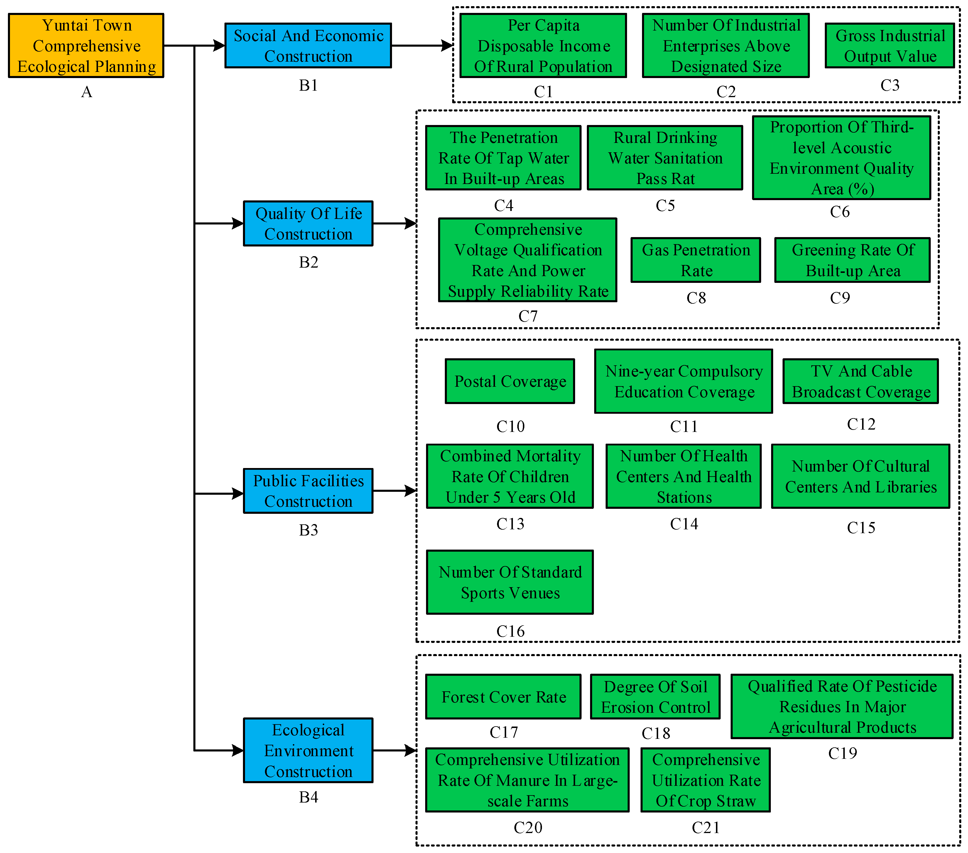
3. Development of Comprehensive Ecological Planning Indicator System

3.1. Comprehensive Ecological Township Development Evaluation Index System

Creating ecological townships is an important measure to achieve a “win-win” situation for economic development and environmental improvement in rural areas. It is also an important form of promoting environmental development in townships and improving the level of ecological civilization [19]. On 2 July 2002, the Ministry of Ecology and Environment of the People’s Republic of China proposed the “National Regulations on Assessment and Acceptance of Environmentally Beautiful Towns and Towns (Trial)” (hereinafter referred to as the “Regulations”). It has preliminarily determined the Chinese government’s ecological town development direction from three perspectives: natural environment, public facilities, and economic development. It is necessary to increase the income of rural populations while seeking a balance between economic development and environmental protection.
Due to the fact that the Regulations are over 20 years old, many standards are no longer suitable. Based on the “regulations” and related research, combined with the convenience of data acquisition and the actual situation of Yuntai Town, four categories of indicators have been developed. These indicators are for socio-economic development, quality of life development, public facility construction, and ecological environment development [20,21,22]. Additionally, by using the assessment indicators of Chongqing as the standard, the compliance of various indicators in Yuntai Town was compared, as shown in Table 1.

3.2. Key Planning Points for Comprehensive Ecological Townships

From Table 1, among the four major indicators of socio-economic development, quality of life development, public facility development, and ecological environment development, several indicators did not meet the indicator requirements of Chongqing. They include the number of industrial enterprises above designated size, total industrial output value, proportion of third level acoustic environment quality areas, gas permeability, greening rate in built-up areas, soil erosion control degree, and qualified rate of pesticide residues in major agricultural products. Due to the focus on social and economic development in the development planning of Yuntai Town, this indicator will significantly affect other indicators, accounting for a large proportion in the overall development plan. In order to be consistent with the development plan of Yuntai Town, priority has been given to socio-economic development in this study. Therefore, in Yuntai Town’s subsequent development, it needs to pay special attention to these indicator requirements and prioritize social and economic development in the planning. However, while developing the economy, life quality development, public facility development, and ecological environment development indicators cannot be lowered. To achieve the SD of Yuntai Town, according to the new indicator requirements of Chongqing, a comprehensive ecological plan for Yuntai Town has been formulated in the following study.

4. Comprehensive Ecological Development Evaluation of Yuntai Town

Due to different types of indicators and significant numerical differences in ecological development, a combination of qualitative and quantitative AHP was chosen for analysis [23,24,25]. By decomposing complex problems into several levels and factors, and performing simple comparisons and calculations between each factor, different scheme weights can be obtained [26,27].

4.1. Hierarchical Model Development for Evaluation Indicators and Weights Confirmation

According to Table 1, a comprehensive ecological planning evaluation model for Yuntai Town was established, which is divided into target layer (A), criterion layer (B), and indicator layer (C). The target layer is the comprehensive ecological planning of Yuntai Town. The criterion layer includes socio-economic development, quality of life development, public facility development, and ecological environment development. There are a total of 21 indicators in the indicator layer, as shown in Figure 1.
In Figure 1, there are four factors in the criterion layer, namely socio-economic development, quality of life development, public facility development, and ecological environment development. A judgment matrix was constructed for the criterion layer, and the importance of each factor was confirmed using expert scoring combined with literature analysis [28,29,30]. A consistency check of the judgment matrix shows that the consistency ratio is less than 0.1, indicating that the judgment matrix has acceptable consistency. Based on the weight calculation results, the final weights of each factor in the indicator layer were obtained, as shown in Table 2.

4.2. Single Factor Evaluation Method and Comprehensive Evaluation Results

The single factor evaluation method was used in the experiment to calculate the single factor index values of each factor. Equation (1) is the formula for calculating positive indicators.
P i * 1 = A i * / B i *
In Equation (1), P i * 1 is the single factor index value of indicator i * , A i * is the current value of indicator i * , and B i * is the standard value of indicator i * . When P i * 1 > 1 , it does not interfere with the evaluation result, with a value of 1. Equation (2) is negative indicators’ calculation formula.
P i * 2 = max A i * / A i * min
In Equation (2), P i * 2 is the single factor index value of indicator i * , max is the maximum value of indicator i * , and min is the minimum value of indicator i * . When P i * 2 > 1 , it does not interfere with the evaluation results, with a value of 1. Table 3 shows single factor evaluation scores of various indicators in Yuntai Town.
In Table 3, standard values are taken as average values of each township in Changshou District, Chongqing City, and China in 2020. Due to some data being non-public, some data will not be displayed. County-level data were taken as the standard value first. When county-level data were incomplete, provincial data were used (Chongqing is a municipality directly under the central government). When both county-level and provincial-level data were incomplete, national level data were used as the standard value.
According to Table 3, there are several indicators in Yuntai Town that do not meet the regional or national standard values. They include the number of industrial enterprises above designated size, total industrial output value, proportion of tertiary acoustic environment quality areas, gas coverage rate, soil erosion control degree, and qualified rate of pesticide residues in major agricultural products. Among them, the difference between gas coverage rate as well as qualified rate of pesticide residues in major agricultural products and the standard values is relatively small. However, there are significant gaps between the standard values and the number of industrial enterprises above designated size as well as total industrial output value.
The above single factor evaluation method can be used to obtain scores of different indicators. Results of comprehensive single factor evaluation can be calculated by using Equation (3) for comprehensive score of Yuntai Town.
E I = i * = 1 n W i * × P i *
In Equation (3), E I means index, n represents indicator number, W i * is indicator weight, and P i * refers to single factor index value.
Indicator weight calculations are influenced by subjective factors. To improve the objectivity of comprehensive scores and weight parameter accuracy, an improved fuzzy clustering algorithm was used for weight calculation. On the basis of dimensionality reduction of original data, σ 2 covariance matrix was introduced. It is the sample vector’s average value, which is used to describe the data matrix’s compactness, and it can improve clustering effectiveness. Additionally, after optimizing parameters of Possible C-Means (PCM), it is combined with Fuzzy C-Means (FCM) to obtain Possible Fuzzy C-Means (PFCM) [31,32]. The optimal number of clusters c was determined by improved PFCM. Then, the best clustering center matrix was obtained by fuzzy linear discriminant analysis (FLDA) [33]. In PFCM, it is necessary to measure the issue of increased operational costs caused by FCM parameters. Firstly, it is necessary to improve the objective function JPCM by using Equations (4) and (5).
J P C M = i = 1 c j = 1 n t i j m d i j 2 σ 2 m 2 i = 1 c j = 1 n ( 1 t i j m ) 2
σ 2 = 1 n j = 1 n x j x ¯ 2 , x ¯ = 1 n j = 1 n x j
In Equations (4) and (5), c is cluster number. m is fuzzy weighting number. d i j is Euclidean distance from sample x j to cluster center V i . t i j m is typical value of j -th sample point for class i. Formula (6) is the improved PFCM algorithm’s objective function JPFCM.
J P F C M = i = 1 c j = 1 n ( a u i j m + b t i j p ) d i j 2 + σ 2 m 2 c i = 1 c j = 1 n ( 1 t i j m ) p
In Equation (6), uij is the membership degree of the j -th sample point belonging to class i . a ,   b ,   p represent parameters. Equation (7) is the calculation of sample typical value t i j .
t i j ( γ + 1 ) = 1 1 + σ 2 m 2 c ( ( d i j γ ) 2 ) 1 p 1
In Equation (7), γ is the iteration number. Equation (8) is the calculation of class central matrix v i j .
v i j ( γ + 1 ) = j = 1 n ( a ( u i j γ ) m + b ( t i j γ ) p ) x j j = 1 n ( a ( u i j γ ) m + b ( t i j γ ) p )
Equation (9) is the calculation of fuzzy membership matrix u i j .
u i j ( γ + 1 ) = 1 k = 1 c ( d i j γ d k j γ ) 2 m 1 , 1 i c , 1 j n
Equation (10) is the calculation of fuzzy inter class dispersion matrix S f B .
S f B = i = 1 c j = 1 n ( a u i j γ + b t i j γ ) m × ( v i γ x ¯ ) ( v i γ x ¯ ) T
Equation (11) is the calculation of fuzzy total dispersion matrix S f T .
S f T = i = 1 c j = 1 n ( a u i j γ + b t i j γ ) m × ( x i x ¯ ) ( x j x ¯ ) T
In Equation (11), v i is the cluster center vector of class i . The combination of FLDA and fuzzy clustering algorithm can improve its clustering accuracy [34]. After combining FLDA with improved PFCM, the following parameters’ calculation methods can be obtained. Wherein, Equation (12) is the calculation of cluster center matrix v i .
v i γ = ω T v i γ
In Equation (12), λ is the eigenvalue and ω is the eigenvector. Equation (13) represents the calculation of Euclidean distance d i j from sample to cluster center.
d i j γ = y i v i γ
Equation (14) is the calculation of fuzzy membership function value u i j .
u i j ( γ + 1 ) = 1 k = 1 c ( d i j γ d k j γ ) 2 m 1 , 1 i c , 1 j n
Equation (15) is the calculation of typical value t i j .
t i j ( γ + 1 ) = 1 1 + σ 2 m 2 c ( ( d i j γ ) 2 ) 1 p 1
Equation (16) is the calculation of cluster center matrix v i j .
v i j ( γ + 1 ) = j = 1 n ( a ( u i j γ ) m + b ( t i j γ ) p ) x j j = 1 n ( a ( u i j γ ) m + b ( t i j γ ) p )
Figure 2 shows specific steps of combining FLDA with the improved PFCM algorithm.
To evaluate the performance of the evaluation model proposed in this experiment, the subjective weight, objective weight, mean method, and weight value changes of the method proposed in this experiment were compared. As seen in Figure 3, there was a significant difference in weight changes between the subjective weight method and objective weight method. If either method is used separately, there may be subjective arbitrariness, or the calculation results of objective data may not match the actual situation. Therefore, this study adopted a subjective and objective integrated weight optimization algorithm for weight calculation.
To verify the effectiveness of the fuzzy clustering method proposed in this experiment, simulation analysis was conducted in Matlab to determine the execution efficiency of the improved fuzzy clustering method. Six sets of data points with a sample size of 120 were randomly generated in Matlab software. Figure 4a shows the distribution of generated data. Then, an improved fuzzy clustering method was used to analyze these data, and Figure 4b shows the results. By comparing Figure 4a,b, which categories each data point belongs to can be accurately seen. Moreover, the data distribution of the clustering results is tight and without crossover, achieving a clustering accuracy of 100%. This indicates that the improved fuzzy clustering method has good clustering performance.
Box graphs can be used for comparing the performance of clustering methods. If the box position is higher and its size is smaller, the algorithm performance is better. In Figure 5, method 1 is FCM [35], method 2 is KFCM [36], method 3 is IFCM [37], and method 4 is the improved fuzzy clustering method proposed in this experiment. KFCM is an improved fuzzy c-means clustering algorithm based on kernel. It maps points in the original space to the feature space through a kernel function. Considering that the points in the original space cannot be divided by a linear function, they are transformed into a higher dimensional space. KFCM can find a linear function in this high-dimensional space, which is easy to partition the original data. The IFCM algorithm introduces intuitive fuzzy membership on the basis of the FCM algorithm. Fuzzy clustering defined by an intuitionistic fuzzy set can converge to a more ideal cluster center. From Figure 5, the results for four methods in dataset 1 are consistent. In datasets 2 and 3, the optimization algorithm in this experiment is significantly superior to other algorithms.
The convergence and accuracy of different methods were compared in the experiment, as shown in Figure 6. From the figure, the improved method has a fast convergence speed, and its final loss function value is the lowest among all methods. Moreover, its accuracy is the highest among all compared methods. The results show that this method has better performance.

4.3. Analysis of the Advantages of Yuntai Town

Yuntai Town has superior geographical conditions. It has convenient road and railway transportation, as shown in Figure 7.
In Figure 7, G243 runs through Yuntai Town. It connects Haitang Town to the north and directly leads to Dianjiang County, and connects Shiyan Town and Gelan Town to the south and directly leads to Changshou District. S513 connects the Wuhua Mountain Scenic Area to the west and turns toward Changshou District. Chongqing Wanzhou Railway passes through the industrial zone of Yuntai Town and is the main artery for bulk commodity trading in Yuntai Town. G50 passes north through Haitang Town and Chenxi Town and directly leads to Dianjiang County. Additionally, it passes south through Changshou District and directly leads to Chongqing City. X189 connects Yantai Town and Baojia Town.
For the ecological environment, Yuntai Town’s forest coverage rate is as high as 72%, and its air quality is good. There are abundant water resources, including Sandiaogou Reservoir, Chaoyang Reservoir, Shitahe Reservoir, Hongqi Reservoir, Jumudong Reservoir, etc. The main river, Longxi River, has a drainage area of 23 square kilometers, accounting for 25.84% of the total area, as shown in Figure 8.
For hydraulic resources, Yuntai Town has a vast water area and a large difference in terrain height, making it rich in hydropower resources. Currently, hydropower development is in its infancy and has high development potential.
For mineral resources, Yuntai Town’s resources mainly consist of natural gas and sandstone. Its proven natural gas reserves total 2.9 billion cubic meters, accounting for 0.67% of the total natural gas reserves in Chongqing.
For tourism resources, Yuntai Town mainly has cultural tourism resources such as ancient ancestral halls, Yuntai Temple, and Shengshui Temple. Yuntai Town itself does not have famous natural tourism resources. But, it is adjacent to the Wuhua Mountain Scenic Area and Changshou Lake Scenic Area, and can develop the homestay industry or other tourism supporting industries.
For characteristic industries, as early as the 1990s, Yuntai Town actively carried out the fruit cooperative project and became an important fruit production base in Changshou District. In recent years, Yuntai Town has been committed to creating ecological agriculture and constructing comprehensive projects represented by Qingmai Agriculture Tourism Experience Area. The main tourism resources and characteristic industries are shown in Figure 9.
In terms of economy, Yuntai Town is a national key development town in China, supported by relevant supporting policies. At the same time, it is also a provincial-level central town, a municipal pilot small town, a municipal small and medium-sized enterprise entrepreneurship base, and a strong town in China’s agricultural development. In terms of the ecological environment, Chongqing has been implementing the project of returning farmland to forests in its townships since 2002. As of 2018, the total area of farmland returned to forests in Yuntai Town exceeded 10 square kilometers, accounting for 12.20% of the total area under the jurisdiction. The town government has established a special group for river governance to carry out regular dredging, garbage removal, and dam reinforcement projects for the main tributaries of the Longxi River passing through Yuntai Town.

4.4. Analysis of Restrictive Factors in Yuntai Town

Firstly, the urbanization level of Yuntai Town is relatively low. As a central township in the northeastern region of Chongqing, as of 2020, the urbanization level of Yuntai Town was less than 50%. The lagging level of urbanization leads to incomplete functions of market towns and a lack of driving force for regional socio-economic development.
And there are two main labor problems in Yuntai Town. One is the serious loss of young and middle-aged labor. According to the statistics in 2020, the registered residents of Yuntai Town totaled 50,300, and the permanent population was only 20,900, mostly the elderly and children. Secondly, the quality of labor is relatively low. As of 2020, the population with bachelor’s degrees in Yuntai Town was less than 1%, and the illiteracy rate exceeded 5%.
Thirdly, the comprehensive environmental governance capacity of Yuntai Town is relatively weak. As early as 2013, Yuntai Town had built a 2000 ton sewage treatment plant and a 100 ton garbage treatment plant to achieve centralized treatment of municipal waste. However, in the vast rural areas under its jurisdiction, due to limitations in terrain, transportation, funding, and environmental awareness, pollution from shaping, batteries, pesticides, and other factors is relatively severe. Due to the G243 highway running through the entire built-up area of Yuntai Town, and because the early planning did not reserve space for soundproofing facilities, traffic pollution during the day is severe.

5. Comprehensive Ecological Planning Analysis of Yuntai Town

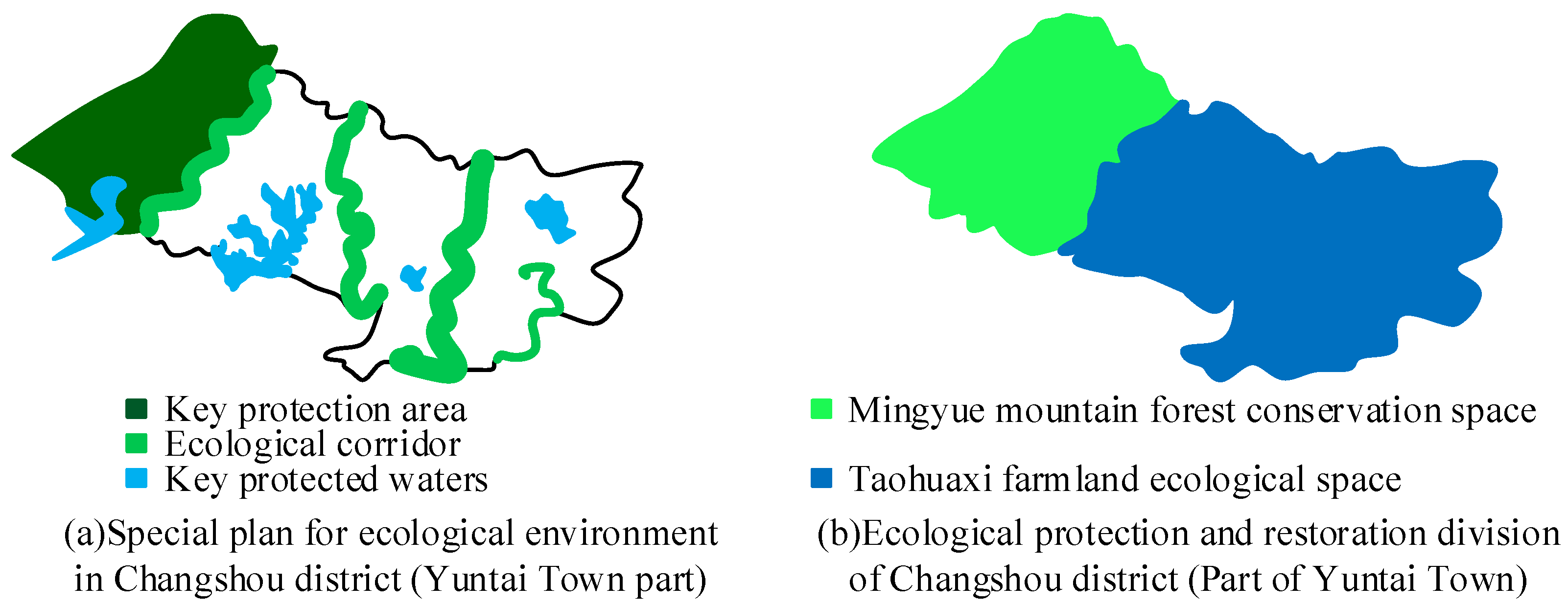
5.1. Planning of Ecological Environment Functional Zone in Yuntai Town

Yuntai Town is a transportation hub connecting the counties in Northeast Chongqing and the central area of Chongqing. It is also an important cargo distribution center in Changshou District. Yuntai Town can radiate several neighboring towns and the vast rural hinterland of Northeast Chongqing. In the ecological comprehensive evaluation of Yuntai Town, the number of industrial enterprises above designated size, the total industrial output value, the proportion of areas with three-level acoustic environment quality, the gas permeability, the greening rate of built-up areas, the degree of soil erosion control, and the qualified rate of pesticide residues of major agricultural products in the four categories of indicators did not meet the requirements of Chongqing. Therefore, in the ecological comprehensive planning of Yuntai Town, a key analysis was conducted on the indicators that did not meet the requirements based on the above comprehensive evaluation results. The research prioritized and targeted these non-compliant projects in the comprehensive planning. At the same time, combined with the development plan of the Yuntai Town government, comprehensive ecological planning was carried out for Yuntai Town. In the study, comprehensive ecological planning was carried out using soil erosion control and the qualified rate of pesticide residues in major crops as examples. According to the overall planning of Changshou District and the actual situation of Yuntai Town, the ecological environment functional area of Yuntai Town is divided into ecological environment functional area and ecological economy functional area.
In March 2022, Changshou District officially launched the “Changshou District Land Space Ecological Protection and Restoration Special Plan (2021–2035)” (hereinafter referred to as the “Plan”), coordinating the integrated protection and restoration of mountains, rivers, forests, fields, lakes, and grasslands throughout the region. The plan proposes four types of ecological spaces and nine major ecological protection and restoration zones, with Yuntai Town as shown in Figure 10.
According to Figure 10a, the ecological environment protection focus in Yuntai Town is on the western mountainous area, central hilly area, eastern Longxi River mainstream area, and main reservoirs. According to Figure 10b, ecological protection and restoration zones in Yuntai Town mainly include forest conservation space and farmland ecological space. It can confirm the two indicators in Table 1 that Yuntai Town did not meet the regional standard values. These two indicators are soil erosion control and qualified rate of pesticide residues in major crops. Based on the overall planning of Changshou District and the actual situation of Yuntai Town, ecological environment functional zones of Yuntai Town are divided into ecological environment functional zones and ecological economy functional zones.
Most villages in Yuntai Town are located in hilly areas, and a few are located in river valleys and alluvial plain. The soil quality in hilly areas is relatively loose, and the soil layer is thin, resulting in limited soil and water conservation capacity. In addition, in recent years, the planning for returning farmland to forests has not been scientific. Additionally, eucalyptus trees have been planted on a large scale to save costs, resulting in severe soil erosion. Although the Taohua River in the built-up areas has been renovated in recent years, the overall ecological environment quality has not improved significantly. In addition, the development of environmental protection infrastructure in Yuntai Town is average, and disposal of domestic waste in built-up area relies on the Gelan Town garbage dump 10 km away. These result in some domestic waste being unable to be disposed of in a timely manner. Moreover, there are no waste treatment facilities for industrial areas, and industrial waste is casually dumped, resulting in a decrease in the quality of land sources near the industrial areas. The ecological environment functional area planning of Yuntai Town is shown in Figure 11.
In Figure 11, a total of one forest ecological environment functional area and three soil and water conservation ecological functional areas have been planned. The forest ecological environment functional zone is the Mingyue Mountain Forest Conservation and Restoration Zone in Changshou District. Area A is a traditional fruit planting area in Yuntai Town, mainly producing fruits such as grapes, pears, and plums. Due to the long-term use of pesticides, the nearby land and water sources have been degraded. Region B is a hilly area upstream of the Fanjiaqiao Reservoir, with developed terraced agriculture and severe agricultural pollution. There are few rivers in Region C, and the main crops planted are drought-resistant crops such as pepper and sorghum. In recent years, a large number of eucalyptus trees have further damaged the already fragile soil and water environment.
The planned industrial waste treatment facility is located near the entrance of the G50 highway in the southeast of the industrial zone, with relatively flat terrain and few surrounding farms and residents. The domestic waste treatment facilities are located along the provincial road S513, between the ecological corridor and the built-up area of Yuntai Town, which has less environmental pollution in Yuntai Town.

5.2. Planning of Ecological and Economic Functional Zones in Yuntai Town

Yuntai Town is adjacent to Changshou District and Dianjiang County. On the one hand, it bears the urban pressure from urban leakage. On the other hand, it also bears the rural pressure generated during the transfer of vast rural areas in Northeast Chongqing to the main urban area of Chongqing. For Yuntai Town, its main agricultural products, industrial products, and service-oriented goods not only need to be used by residents in the built-up area and rural areas within the jurisdiction, but also to meet the needs of some outside the jurisdiction. The planning of the ecological and economic functional zones in Yuntai Town is shown in Figure 12.
In Figure 12a, Chengxi Town, Gaofeng Town, Baojia Town, and Youhe Town are all under the jurisdiction of Dianjiang County. Due to the distance from the urban area of Dianjiang County and the weak economic radiation capacity of Dianjiang County itself, towns near the jurisdiction of Changshou District will be affected by Yuntai Town. The ecological and economic functions of Yuntai Town were divided into agricultural production functional zones, industrial production functional zones, and commercial and service functional zones. The traditional fruit planting park in Yuntai Town has adopted a contract system, mainly planting varieties such as citrus and pear. In Figure 12b, combining the geographical location and characteristics of planting varieties, the fruit plantation in Area A has been renovated. Through analysis, different agricultural product planting areas, industrial product production areas, and economic and social service areas were identified.

5.3. Benefit Analysis of Comprehensive Ecological Planning in Yuntai Town

In terms of environmental benefits, Yuntai Town can further optimize the quality of the surface water environment through comprehensive ecological planning, improve the acoustic environment, and effectively control the noise of transportation arteries. The pollution caused by production and household waste in the environment will be reduced, and the degree of soil erosion and pollution in rural areas will be alleviated.
In terms of economic benefits, Yuntai Town has optimized the structure of the urban and rural economy through the adjustment of industrial structure. At the same time, Yuntai Town has increased the proportion of modern high-tech industries to the tertiary industry, further accelerating the process of urbanization. Yuntai Town has driven efforts to investment and promoted the development of related industries in the entire town through a point-to-point approach.
In terms of social benefits, Yuntai Town promotes environmental protection concepts through various media such as television, promoting the establishment of public environmental awareness. Moreover, the government vigorously supports the environmental protection industry, effectively improving the effectiveness of environmental protection. The significant improvement in the moral civilization level of residents has further promoted the development process of a harmonious society.
For SD, economic development and environmental protection are closely related. Yuntai Town strictly follows the SD principle for economic development through the promotion of environmental protection and economic policies. These measures have promoted the coordinated development of society and economy, humanity and nature, resources and environment, and economic development.
Yuntai Town has effectively ensured its environmental, economic, and social benefits by formulating reasonable economic and environmental protection measures. This has important practical significance for the SD of Yuntai Town and has further expanded the development space of Yuntai Town.

6. Discussion

The SD of townships is an important factor affecting the process of urbanization [38]. From the coordination of ecological niche theory, a scholar proposed the strategy of scientific planning and design of natural ecological niches. He proposed that urban and rural planning should follow the principles of ecological architecture design, coordinate urban and rural ecological service functions, and coordinate the planning of industrial, ecological and municipal layout [39]. The fragmentation of urban ecological spaces in China has aroused widespread interest among researchers due to the impact of early compressed urbanization. In order to avoid subjective randomness and single analysis of ecological space in urbanized areas, the researchers took the central urban area of Wuhan Center as the main research area and combined the analysis model to conduct a comprehensive evaluation of ecological network space [40]. The evaluation of rural tourism competitiveness at the township level is a necessary condition for planning and developing the tourism industry. A classification model for evaluating the competitiveness and development patterns of urban-level rural tourism was constructed using integrated multi-source data in the study. Taking township units as an example in the study, four different models were identified based on comprehensive scores and the level of internal balance within the industry, and corresponding policy recommendations for optimizing the rural tourism industry were provided [41]. From this, it can be seen that appropriate methods need to be adopted for analysis in the planning of township development. Research has shown that when conducting sustainable development research, AHP is often used to construct indicators [42]. When conducting comprehensive ecological planning for townships, the AHP method can be used to construct an indicator system. In order to improve the objectivity of this method, the fuzzy analytic hierarchy process can be introduced to improve the method [43].
The research focused on Yuntai Town, Changshou District, Chongqing as the research object, and analyzed the physical geography information and socio-economic situation of Yuntai Town. The urbanization level of Yuntai Town is relatively low, the labor force is insufficient, and the ability to comprehensively manage the environment is relatively weak. To achieve SD in Yuntai Town, further in-depth analysis of the township is needed [44]. The SD of townships is influenced by subjective factors and objective environment [45]. In the comprehensive planning process of constructing Yuntai Town, it is necessary to fully consider the influence of environmental factors and subjective human factors [46]. In this study, in order to reduce the impact of subjective factors on experts, a fuzzy evaluation method was introduced to improve AHP. On this basis, a comprehensive planning and evaluation index system for Yuntai Town was established. Finally, targeted suggestions were proposed for the deficiencies in the comprehensive ecological planning of Yuntai Town. In this study, the overall planning of Changshou District and the actual situation of Yuntai Town were combined to divide the ecological and environmental functional areas of Yuntai Town. This functional area was specifically divided into an ecological environment functional area and ecological economy functional area. In the divided ecological environment functional area, a total of one forest ecological environment functional area and three soil and water conservation ecological functional areas have been planned. The planned industrial waste treatment facility is located near the entrance of the G50 highway in the southeast of the industrial zone, with relatively flat terrain and few surrounding farms and residents. The domestic waste treatment facilities are located along the provincial road S513, between the ecological corridor and the built-up area of Yuntai Town, which has less environmental pollution in Yuntai Town. In the divided ecological and economic functional areas, different agricultural product planting areas, industrial product production areas, and economic and social service areas were identified through analysis. Yuntai Town has effectively ensured its environmental, economic, and social benefits by formulating reasonable economic and environmental protection measures, which has both theoretical and practical significance for the SD of Yuntai Town.

Author Contributions

Y.L. and J.P. conceived the research idea and designed the study. Y.L. and F.Z. visited the dairy farms and collected the data. J.P. and F.Z. performed data analysis. All authors discussed the results and wrote the manuscript. All authors have read and agreed to the published version of the manuscript.

Funding

This research received no external funding.

Institutional Review Board Statement

Not applicable.

Informed Consent Statement

Not applicable.

Data Availability Statement

The data used to support the findings of this study are available from the corresponding author upon request.

Conflicts of Interest

The authors declare no conflict of interest.

References

  1. Banerjee, S.; Khan, M.A.; Husnain, M. Searching appropriate system boundary for accounting india’s emission inventory for the responsibility to reduce carbon emissions. J. Environ. Manag. 2021, 295, 112907. [Google Scholar] [CrossRef]
  2. Moretti, S.; BErtoncini, E.I.; Abreujunior, C.H. Characterization of raw swine waste and effluents treated anaerobically: Parameters for Brazilian environmental regulation construction aiming agricultural use. J. Mater. Cycles Waste Manag. 2021, 23, 165–176. [Google Scholar] [CrossRef]
  3. Graafland, J.; BovenbErg, L. Government regulation, business leaders’ motivations and environmental performance of SMEs. J. Environ. Plan. Manag. 2020, 63, 1335–1355. [Google Scholar] [CrossRef]
  4. Bao, Q.; Shao, M.; Yang, D. Environmental regulation, local legislation and pollution control in China. Environ. Dev. Econ. 2021, 26, 321–339. [Google Scholar] [CrossRef]
  5. Hoang, T.; Nguyen, T.; Phan, T. Government environmental regulation, corporate social responsibility, ecosystem innovation strategy and sustainable development of Vietnamese seafood enterprises. Int. J. Data Netw. Sci. 2021, 5, 713–726. [Google Scholar] [CrossRef]
  6. Xu, X.; Cui, Y.; Zhong, Y. Impact of Environmental Regulation and FDI on Green Total Factor Productivity: Evidence from China. Environ. Eng. Manag. J. 2021, 20, 177–184. [Google Scholar] [CrossRef]
  7. Sun, H.; Gao, G. Research on the carbon emission regulation and optimal state of market structure: Based on the perspective of evolutionary game of different stages. RAIRO-Oper. Res. 2022, 56, 2351–2366. [Google Scholar] [CrossRef]
  8. Li, Z.; Zhang, J.; Sun, Q.; Shi, W.; Tao, T.; Fu, Y. Moxifloxacin detection based on fluorescence resonance energy transfer from carbon quantum dots to moxifloxacin using a ratiometric fluorescence probe. New J. Chem. 2022, 46, 4226–4232. [Google Scholar] [CrossRef]
  9. Li, Y.; Chiu, Y.H.; Liu, Y.; Lin, T.Y.; Chang, T.H. The Impact of the Media and Environmental Pollution on the Economy and Health Using a Modified Meta 2-Stage EBM Malmquist Model. INQUIRY J. Health Care Organ. Provis. Financ. 2020, 57, 105–116. [Google Scholar] [CrossRef]
  10. Yan, C.; Di, D.; Li, G.; Wang, J. Environmental regulation and the supply efficiency of environmental public services: Evidence from environmental decentralization of 289 cities in China. Growth Chang. 2022, 53, 515–535. [Google Scholar] [CrossRef]
  11. Ibrahim, R.L.; Al-mulali, U.; Ozturk, I.; Bello, A.K.; Raimi, L. On the criticality of renewable energy to sustainable development: Do green financial development, technological innovation, and economic complexity matter for China? Renew. Energy 2022, 199, 262–277. [Google Scholar] [CrossRef]
  12. Wang, X.; Wang, Q. Research on the impact of green finance on the upgrading of China’s regional industrial structure from the perspective of sustainable development. Resour. Policy 2021, 74, 102436. [Google Scholar] [CrossRef]
  13. Hsu, C.C.; Quang-Thanh, N.; Chien, F.S.; Li, L.; Mohsin, M. Evaluating green innovation and performance of financial development: Mediating concerns of environmental regulation. Environ. Sci. Pollut. Res. 2021, 28, 57386–57397. [Google Scholar] [CrossRef]
  14. Ebenuwa, A.U.; Tee, K.F.; Zhang, Y. Fuzzy-Based Multi-Objective Design Optimization of Buried Pipelines. Int. J. Uncertain. Fuzziness Knowl.-Based Syst. 2021, 29, 209–229. [Google Scholar] [CrossRef]
  15. Atanassov, K.T. New topological operator over intuitionistic fuzzy sets. J. Comput. Cogn. Eng. 2022, 1, 94–102. [Google Scholar] [CrossRef]
  16. Vasko, F.J.; Lu, Y.; McNally, B. A Simple Methodology that Efficiently Generates All Optimal Spanning Trees for the Cable-Trench Problem. J. Comput. Cogn. Eng. 2022, 1, 13–20. [Google Scholar] [CrossRef]
  17. Wang, Z.J. Eigenproblem driven triangular fuzzy analytic hierarchy process. Inf. Sci. 2021, 578, 795–816. [Google Scholar] [CrossRef]
  18. Duan, Y.; Xiong, J.; Cheng, W.; Wang, N.; Li, Y.; He, Y.; Liu, J.; He, W.; Yang, G. Flood vulnerability assessment using the triangular fuzzy number-based analytic hierarchy process and support vector machine model for the Belt and Road region. Nat. Hazards J. Int. Soc. Prev. Mitig. Nat. Hazards 2022, 110, 269–294. [Google Scholar] [CrossRef]
  19. Weng, G.; Pan, Y.; Li, J. Study on the Influencing Factors and Acting Path of the Sustainable Development of Rural Tourism Based on EEAM-ISM Model. Sustainability 2021, 13, 5682. [Google Scholar] [CrossRef]
  20. Liu, X.; Liu, H.; Wan, Z.; Wang, L.; Chen, Q. Study on evaluation index system of sustainable development of mine water resources based on PSO-AHP model and fuzzy comprehensive evaluation. J. Intell. Fuzzy Syst. Appl. Eng. Technol. 2021, 41, 4253–4264. [Google Scholar] [CrossRef]
  21. Meethom, W.; Koohathongsumrit, N. A decision support system for road freight transportation route selection with new fuzzy numbers. Foresight 2020, 22, 505–527. [Google Scholar] [CrossRef]
  22. Tafesse, S.; Girma, Y.E.; Dessalegn, E. Analysis of the socio-economic and environmental impacts of construction waste and management practices. Heliyon 2022, 8, e09169. [Google Scholar] [CrossRef] [PubMed]
  23. Cheemakurthy, H.; Garme, K. Fuzzy AHP-Based Design Performance Index for Evaluation of Ferries. Sustainability 2022, 14, 3680. [Google Scholar] [CrossRef]
  24. Pan, W.; Xu, X.; Ming, H.; Chang, C.K. Clustering Mashups by Integrating Structural and Semantic Similarities Using Fuzzy AHP. Int. J. Web Serv. Res. (IJWSR) 2021, 18, 34–57. [Google Scholar] [CrossRef]
  25. Noorollahi, Y.; Senani, A.G.; Fadaei, A.; Simaee, M.; Moltames, R. A framework for GIS-based site selection and technical potential evaluation of PV solar farm using Fuzzy-Boolean logic and AHP multi-criteria decision-making approach. Renew. Energy 2022, 186, 89–104. [Google Scholar] [CrossRef]
  26. Wang, H. Construction of a Near-Natural Estuarine Wetland Evaluation Index System Based on Analytical Hierarchy Process and Its Application. Water 2021, 13, 2116. [Google Scholar] [CrossRef]
  27. Othman, A.G.; Ali, K.H.; Wan, M. Application of Geographic Information System (GIS) and Analytic Hierarchy Process (AHP) Technology to Study Land Use Change in Pendang, Kedah. Plan. Malays. 2021, 19, 226–237. [Google Scholar]
  28. Hou, J.; Qiao, J.; Han, X. Energy-Saving Clustering Routing Protocol for Wireless Sensor Networks Using Fuzzy Inference. IEEE Sens. J. 2022, 22, 2845–2857. [Google Scholar] [CrossRef]
  29. John, C.A.; Tan, L.S.; Tan, J.; Kiew, P.L.; Shariff, A.M.; Abdul Halim, H.N. Selection of Renewable Energy in Rural Area Via Life Cycle Assessment-Analytical Hierarchy Process (LCA-AHP): A Case Study of Tatau, Sarawak. Sustainability 2021, 13, 11880. [Google Scholar] [CrossRef]
  30. Githinji, T.W.; Dindi, E.W.; Kuria, Z.N.; Olago, D.O. Application of analytical hierarchy process and integrated fuzzy-analytical hierarchy process for mapping potential groundwater recharge zone using GIS in the arid areas of Ewaso Ng’iro—Lagh Dera Basin, Kenya. HydroResearch 2022, 5, 22–34. [Google Scholar] [CrossRef]
  31. Azam, M.H.; Hasan, M.H.; Abdulkadir, S.J.; Hassan, S. Prediction of Sunspots using Fuzzy Logic: A Triangular Membership Function-based Fuzzy C-Means Approach. Int. J. Adv. Comput. Sci. Appl. 2021, 12, 357–362. [Google Scholar] [CrossRef]
  32. Arora, J.; Tushir, M. An Enhanced Spatial Intuitionistic Fuzzy C-means Clustering for Image Segmentation. Procedia Comput. Sci. 2020, 167, 646–655. [Google Scholar] [CrossRef]
  33. Rahimi, S.A.; Kolahdoozi, M.; Mitra, A.; Salmeron, J.L.; Navali, A.M.; Sadeghpour, A.; Mir Mohammadi, S.A. Quantum-Inspired Interpretable AI-Empowered Decision Support System for Detection of Early-Stage Rheumatoid Arthritis in Primary Care Using Scarce Dataset. Mathematics 2022, 10, 496. [Google Scholar] [CrossRef]
  34. Banerjee, R.; De, S.; Dey, S. A Novel Facial Expression Recognition System using BMCSA Based Adaptive Neuro-Fuzzy Inference System. Int. J. Uncertain. Fuzziness Knowl.-Based Syst. IJUFKS 2021, 29, 791–813. [Google Scholar] [CrossRef]
  35. Meng, F. Safety Warning Model of Coal Face Based on FCM Fuzzy Clustering and GA-BP Neural Network. Multidiscip. Digit. Publ. Inst. 2021, 13, 1082. [Google Scholar] [CrossRef]
  36. Zhong, Y.; Hao, J.; Liao, R.; Wang, X.; Wang, F. Mechanical defect identification for gas-nsulated switchgear equipment based on time-frequency vibration signal analysis. High Volt. 2020, 6, 531–542. [Google Scholar] [CrossRef]
  37. Dong, Z.; Lin, L.; Cao, H.; He, X.; Chen, P.; Gao, C. Distribution Network Dynamic Reconfiguration Based on Improved Fuzzy C-Means Clustering with Time Series Analysis. IEEJ Trans. Electr. Electron. Eng. 2022, 17, 174–182. [Google Scholar] [CrossRef]
  38. Jakovljevic, M.; Timofeyev, Y.; Ranabhat, C.L.; Fernandes, P.O.; Teixeira, J.P.; Rancic, N.; Reshetnikov, V. Real GDP growth rates and healthcare spending–comparison between the G7 and the EM7 countries. Glob. Health 2020, 16, 64–76. [Google Scholar] [CrossRef]
  39. Yao, Z. Coordinated Development Practice of Urban Architectural Design and Urban and Rural Planning Based on Ecological Niche Theory. Eng. Adv. 2023, 3, 89–92. [Google Scholar] [CrossRef]
  40. Hu, C.; Wang, Z.; Wang, Y.; Sun, D.; Zhang, J. Combining MSPA-MCR model to evaluate the ecological network in Wuhan, China. Land 2022, 11, 213. [Google Scholar] [CrossRef]
  41. Jia, Z.; Jiao, Y.; Zhang, W.; Chen, Z. Rural tourism competitiveness and development mode, a case study from chinese township scale using integrated multi-source data. Sustainability 2022, 14, 4147. [Google Scholar] [CrossRef]
  42. Abdallah, S.B.; Parra-López, C.; Elfkih, S.; Suárez-Rey, E.M.; Romero-Gámez, M. Sustainability assessment of traditional, intensive and highly-intensive olive growing systems in Tunisia by integrating Life Cycle and Multicriteria Decision analyses. Sustain. Prod. Consum. 2022, 33, 73–87. [Google Scholar] [CrossRef]
  43. Fatemi, M.; Rezaei-Moghaddam, K.; Karami, E.; Hayati, D.; Wackernagel, M. An integrated approach of Ecological Footprint (EF) and Analytical Hierarchy Process (AHP) in human ecology: A base for planning toward sustainability. PLoS ONE 2021, 16, e0250167. [Google Scholar] [CrossRef]
  44. Liu, W.; Du, M.; Bai, Y. Mechanisms of Environmental Regulation’s Impact on Green Technological Progress—Evidence from China’s Manufacturing Sector. Sustainability 2021, 13, 1600. [Google Scholar] [CrossRef]
  45. Chen, X.; Chen, Z. Can China’s environmental regulations effectively reduce pollution emissions? Int. J. Environ. Res. Public Health 2021, 18, 4658. [Google Scholar] [CrossRef] [PubMed]
  46. Barma, M.; Modibbo, U.M. Multiobjective mathematical optimization model for municipal solid waste management with economic analysis of reuse/recycling recovered waste materials. J. Comput. Cogn. Eng. 2022, 1, 122–137. [Google Scholar] [CrossRef]
Figure 1. Comprehensive ecological planning evaluation index system.
Sustainability 15 11153 g001
Figure 2. Steps for improving the algorithm.
Sustainability 15 11153 g002
Figure 3. Index weight change of different methods.
Sustainability 15 11153 g003
Figure 4. Clustering results of improved algorithm.
Sustainability 15 11153 g004
Figure 5. Comparison results of box diagrams of different methods.
Sustainability 15 11153 g005
Figure 6. Comparison of convergence and accuracy.
Sustainability 15 11153 g006
Figure 7. Road and railway traffic conditions in Yuntai Town.
Sustainability 15 11153 g007
Figure 8. Main water resources in Yuntai Town.
Sustainability 15 11153 g008
Figure 9. Main tourism resources and characteristic industries of Yuntai Town.
Sustainability 15 11153 g009
Figure 10. Special plan for ecological environment and ecological protection and restoration division.
Sustainability 15 11153 g010
Figure 11. Yuntai town ecological restoration functional area planning.
Sustainability 15 11153 g011
Figure 12. Yuntai town’s economic radiation range and planning of ecological and economic functional areas.
Sustainability 15 11153 g012
Table 1. Comprehensive ecological planning indicators of Yuntai Town.
Indicator TypeIndex Serial NumberIndex2020 DataCompliance Status (Yes/No)
Social and economic development1Per capita disposable income of rural population (CNY/year)20,104Yes
2Number of industrial enterprises above designated size7No
3Gross industrial output value (CNY billion/year)12.03No
Quality of life development4The penetration rate of tap water in built-up areas (%)100Yes
5Rural drinking water sanitation pass rate (%)99.7Yes
6Proportion of third-level acoustic environment quality area (%)3.07No
7Comprehensive voltage qualification rate and power supply reliability rate (%)100Yes
8Gas penetration rate (%)54.7No
9Greening rate of built-up area (%)43No
Public facilities development10Postal coverage (%)100Yes
11Nine-year compulsory education coverage (%)100Yes
12TV and cable broadcast coverage (%)100Yes
13Combined mortality rate of children under 5 years old (%)3.71Yes
14Number of health centers and health stations18Yes
15Number of cultural centers and libraries26Yes
16Number of standard sports venues11Yes
Ecological environment development17Forest cover rate (%)72Yes
18Degree of soil erosion control (%)>7No
19Qualified rate of pesticide residues in major agricultural products (%)>87No
20Comprehensive utilization rate of manure in large-scale farms (%)>92Yes
21Comprehensive utilization rate of crop straw (%)>97Yes
Table 2. Total weight of each factor in the township ecological comprehensive planning.
/B1B2B3B4Weights
C10.3181///0.1217
C20.2091///0.2481
C30.4728///0.0301
C4/0.2073//0.0598
C5/0.4172//0.0849
C6/0.0511//0.0462
C7/0.1038//0.0203
C8/0.1625//0.0281
C9/0.0581//0.0183
C10//0.3241/0.0699
C11//0.2236/0.0520
C12//0.0762/0.0403
C13//0.1382/0.0069
C14//0.0574/0.0108
C15//0.0403/0.0057
C16//0.1402/0.0371
C17///0.14190.0238
C18///0.08250.0078
C19///0.23670.0151
C20///0.33280.0053
C21///0.20610.0678
Table 3. Single factor evaluation of each index in Yuntai Town.
Indicator TypeIndex Serial NumberIndex2020 DataChinese AverageChongqing AverageChangshou District AverageSingle Factor Score
Social and economic development1Per capita disposable income of rural population (CNY/year)20,10417,10019,30011,659100
2Number of industrial enterprises above designated size7//16.1743.75
3Gross industrial output value (CNY billion/year)12.03//62.0619.38
Quality of life development4The penetration rate of tap water in built-up areas (%)100%83%85%93.8%100
5Rural drinking water sanitation pass rate (%)99.7%/52%86%100
6Proportion of third-level acoustic environment quality area (%)3.07%//5.30%57.92
7Comprehensive voltage qualification rate and power supply reliability rate (%)100%97.9%99.769%99.99%100
8Gas penetration rate (%)54.7%/65.8%64.63%84.64
9Greening rate of built-up area (%)38.7%42.6%42.9%34.9%100
Public facilities development10Postal coverage (%)100%81%86.91%92.8%100
11Nine-year compulsory education coverage (%)100%95.20%95.50%100%100
12TV and cable broadcast coverage (%)100%99.38%99.40%100%100
13Combined mortality rate of children under 5 years old (%)3.71%7.5%4.69%3.56%100
14Number of health centers and health stations18/6.4016.33100
15Number of cultural centers and libraries2613.820.7815.67100
16Number of standard sports venues118.97//100
Ecological environment development17Forest cover rate (%)72%23%43.1%47.5%100
18Degree of soil erosion control (%)>70%/>90%/63
19Qualified rate of pesticide residues in major agricultural products (%)>87%96.2%97.17%/89.53
20Comprehensive utilization rate of manure in large-scale farms (%)>92%>75%>90%>84%100
21Comprehensive utilization rate of crop straw (%)>97%>85%88.96%>87%100
Disclaimer/Publisher’s Note: The statements, opinions and data contained in all publications are solely those of the individual author(s) and contributor(s) and not of MDPI and/or the editor(s). MDPI and/or the editor(s) disclaim responsibility for any injury to people or property resulting from any ideas, methods, instructions or products referred to in the content.

