Article

Study of Centrality Measures in the Network of Green Spaces in the City of Krakow

by
Karolina Dudzic-Gyurkovich
Faculty of Architecture, Cracow University of Technology, 31-155 Krakow, Poland
Sustainability 2023, 15(18), 13458; https://doi.org/10.3390/su151813458
Submission received: 13 June 2023 / Revised: 23 August 2023 / Accepted: 5 September 2023 / Published: 8 September 2023
(This article belongs to the Special Issue Resilient Cultural Landscapes—Methods, Applications and Patterns)

Abstract

:
Access to and interaction with natural blue or green spaces is a critical factor in quality of life and overall well-being. Studies have shown that exposure to natural areas has health benefits for individuals and society. Incorporating interconnected natural ecosystems into the urban fabric is recognized as a means of building urban resilience and mitigating climate change. It is therefore essential to strengthen and expand existing networks. Mathematical measures of centrality provide a valuable approach to analyzing networks, based on the assumption that certain nodes are more central due to better connectivity. However, due to their complexity, centrality measures are not widely used in urban planning studies, and no research has been conducted in specific Polish conditions. This study aims to fill this gap by testing the usefulness of centrality measures in Krakow’s system of green spaces. The results show that there are few well-connected green areas and that the centrality measures vary. The information provided by this study can contribute to a better understanding of the spatial distribution of green spaces in Krakow and in future to better management and decision-making processes aimed at improving the accessibility of green spaces and the quality of life of residents.

1. Introduction

One of the key components of quality of life and overall well-being is access to and interaction with nature, especially blue or green spaces. This interaction can take place in a variety of ways, including active experiences such as walking, hiking, or picnicking, or passive experiences such as looking at nature through a window. A large body of research has shown that interacting with nature can have several positive effects on both physical and mental health across different social and age groups [1,2]. These benefits include reducing stress, improving mood, enhancing cognitive function, and promoting physical activity.
Furthermore, the presence of natural areas is an important factor in mitigating climate change, promoting biodiversity and building resilience in urbanized regions. The positive impact of green spaces can therefore be considered at many levels. The first is at the local level, where the presence of green spaces, such as neighborhood parks, gardens and green areas within housing estates, contributes to the creation of liveable, high-quality neighborhoods [3] and plays an important role in improving quality of life [4]. Secondly, at the city level, larger green areas serve as important recreational resources [5] and reduce heat island effects [6]. At the regional level, the natural areas are important elements of larger systems that improve the resilience of urban areas and attract tourists, thereby boosting the regional economy [7].
Providing residents with access to natural areas (green and blue) has become increasingly important in cities around the world, as there is a strong tendency for urban populations to grow [8]. Simultaneously, the growth of built-up areas often threatens existing natural areas and hinders the creation of new ones.
As a result, authorities are looking for ways to better understand and manage the relationship between urban development patterns and green spaces [9], in order to secure the fragile balance or correct the deficiencies. Accordingly, advances in academic research allow for the testing of new methods and tools that can be used, for example, to assess the amount of natural areas, gain deeper knowledge, gather information, and manage planning processes.
In this context, the network approach has the potential to reveal and describe different phenomena and activities that are difficult to capture in other ways. Initially used in the social sciences, a network approach assumes that societies are similar to biological systems and, in particular, that they are made up of interconnected units and that the reasons for their behavior are to be found in the network structure rather than in personal motivations [10]. In this case, the network approach refers to a theoretical and methodological framework that analyzes the complex web of relationships and interactions between different entities, such as individuals, organizations or communities. This approach views social systems as networks of nodes and edges, with nodes representing social entities and edges representing the links or relationships between them [11].
Following this, the networks can be applied to various systems, including spatial urban systems, such as cities. According to Batty, cities require a perspective that goes beyond considering them merely as objects and buildings in space. Instead, cities should be perceived as dynamic systems characterized by networks and flows [12]. Consequently, the network approach can provide an opportunity to obtain deeper knowledge on the city systems. In urban studies, networks are created based on the geographical space, where the entities such as roads, junctions, infrastructure lines, and facilities are located [13,14]. Through the process of network modelling, the entities can be transformed into nodes and edges of the network.
Although the networks can be very different, they share structural similarities that can be analyzed using mathematical methods such as centrality, which helps in determining the importance of nodes according to various criteria such as connectivity, distance, and flow [15]. There are several types of centralities that can be applied to the network and according to the research, this family is still growing. Centralities are highly useful, for example, in determining the position and influence of groups or individuals within social media such as Facebook, Twitter, or Instagram, as well as the flow of information [16]. They are also used, for example, in the detection of dangerous content [17] or unhealthy behavior [18]. Therefore, based on the universal properties of networks, the study of centralities can be utilized in numerous research and practical fields.
Despite its advantages, network analysis and centrality measures in particular are still relatively underrepresented in the field of urban planning and design. The existing research applying the network approach and centrality focuses mainly on street patterns, with little to no attention paid to other elements of city structure. Specifically, there is an urge to address the problem of green area management, as they play a vital role in the city’s overall performance in terms of sustainability, ecology, quality of life and visual qualities. In recent years, systems of green areas, often referred to as green networks, have gained attention, as they are perceived as capable of adapting to evolving and growing cities [19,20], and they may also help in the protection of nature, for example, by creating connections and corridors for wildlife [19]. Hence, studying green areas with the network and centrality tools may provide a different perspective of the existing systems, verify their connectivity, and identify weaknesses.
Therefore, in order to fill the identified knowledge gap, it was considered appropriate to explore the concept of centrality, its applicability, benefits, and potential limitations in the analysis of green spaces. This study was aimed at testing the potential of graphs and centrality measures to provide new information and improving the understanding of the spatial patterns of green spaces in the existing urban structure of Kraków. The specific research questions were as follows. Do centrality measures provide new insights and information on the existing system of green areas? If so, how can the centrality measures complement the traditional urban analysis? And finally, are certain parks and urban green spaces in Krakow more important due to their high centrality in the network? The main objective of the study is to explore and determine the usability of graphs and centrality measures in urban analysis using the example of the network of urban parks in Krakow in order to provide data-based evidence and possibly complement the design-based approach. The additional objectives include developing and testing the compound centrality index and indicating centrality-based properties of the studied network.
In the selected case, the existing green spaces, namely public parks and forests of Kraków, are analyzed in terms of their position in the network and relative importance. The methods used in the study include graph theory-based analysis and centrality measures, as well as GIS-based analysis of the urban space of Kraków. The results show that the methods based on graph theory provide deeper and unique knowledge about the characteristics of specific urban parks and the network as a whole, and also revealed the properties of the network and allowed us to indicate the areas for improvement and formulate practical recommendations that can be useful for municipalities and bodies responsible for green area management.
This article is structured as follows. The Section 1 reviews the existing evidence on topics related to the main areas of interest, namely green space management, graph theory, centrality measures, and their application in urban studies. Next, the materials and methods are described with a brief overview of the selected case study. The results are presented in the Section 4 and concluded and discussed in the Section 5 of this manuscript. The last, the Section 6 contains the study limitations and presents lines for further development of centrality research.

2. Literature Review

In this section, a brief summary of the relevant work developed by some researchers or working groups related to the study’s areas of interest is presented. The review covers the following topics: the benefits of natural spaces in the urban environment, the conceptualization of urban systems through networks, and finally, centrality measures in urban studies.

2.1. Benefits of Natural Space

The issue of urban green spaces, or more generally natural spaces, has been extensively studied in previous research. Much attention has been paid to the relationship between the presence of green spaces and positive health outcomes in society [3,21]. Improved mental health and reduced stress levels have also been linked to interaction with nature [22,23,24].
Other research focuses on the benefits for different age, social, or gender groups. For example, a study in the Netherlands found that older adults who lived in greener areas had a lower risk of developing chronic diseases such as cardiovascular disease and diabetes than those who lived in less green areas [25]. Another study by Wolch et al. found that children who had access to green spaces had lower body mass index (BMI) and were less likely to be overweight or obese [1].
In addition, the final years of the COVID-19 pandemic had a significant impact on patterns of green space use. As highlighted by Korpilo et al., people’s reasons for using green spaces changed during the pandemic, with exercise and mental health becoming more important than socializing [26]. Therefore, accessible, nearby green spaces of different sizes are essential for providing people with a place to cope with crisis and stressful situations. For example, when needed, people can escape from the dense and loud urban environment and experience the calming effect of nature, which is proven to lower stress markers [22]. When they have the opportunity and access to a park, they can engage in physical activity, which helps to reduce psychological stresses, anxiety, and depression [27]. Additionally, crisis situations often require individuals to make important decisions or navigate complex emotions. Green spaces offer a tranquil setting for reflection and introspection [28]. Time spent in these spaces allows people to gain perspective, think more clearly, and make better-informed choices.
The proportion of natural areas in the total urban area can vary widely, and in European conditions, the amount of green space per capita can reach values as high as 230 m2 in Helsinki, Finland, and as low as 4 m2 per capita in Athens, Greece [29]. In some cases, the high proportion of green space does not accurately reflect its availability to residents, for example, when a large part of the city’s administrative area is covered by forest, or when the urban development pattern is dispersed and extensive, with a high proportion of private green spaces or undeveloped land. In this case, the area of publicly available green space may be much smaller than the total area of green space in the city. There is a consensus that a higher proportion of green space in urban areas provides several benefits to residents, ranging from self-reported satisfaction and improved quality of life [30] to objective health benefits such as increased physical activity, reduced BMI [1,31], and improved cardiovascular capacity [32].
Accordingly, large areas of vegetation are clearly a positive phenomenon in terms of mitigating climate change and promoting biodiversity. They can reduce the heat island effect, prevent flooding, and improve air quality [33,34,35]. On the other hand, according to a study by Jarvis et al., for residents to derive maximum benefit, green spaces should be easily accessible and provide opportunities for recreational activities. Therefore, simply having green spaces is not enough; accessibility and functionality are also important factors to consider when creating and maintaining urban green spaces [36]. The results of having a low amount of greenery and insufficient accessibility generally include more exposure to stress [28]; children may suffer from behavioral problems as well as impaired cognitive development [37].
There is no doubt that access to nature is important for people’s health and well-being. However, maintaining green spaces can be expensive and space for creating new ones can be limited, especially in urban areas. It is therefore crucial to determine what constitutes sufficient access to nature in residential areas. Existing research varies widely as to what is the most useful way of assessing green space accessibility, and there is no one-size-fits-all solution. However, in attempting to summarize the literature, three main groups of measures can be identified: perception-based measures, distance-based measures, and density-based measures.
As perception-based measures rely on subjective judgements, their applicability in this research is limited. Depending on the focus of the study, the results showed significant differences in which factors were most important for certain groups of visitors. For example, Kaczynski et al. found that the number of facilities was the most important factor for physically active visitors [31], whereas proximity to the park was the most important factor for older people [38]. However, even within the focus groups, visitors’ needs and desires varied.
The distance-based and density-based measures are both objective measures that often use spatial data, maps, and geographic information systems (GIS) to assess green space provision and accessibility. Accessibility measures that use distance as a metric are based on the assumption that proximity to green space is associated with good accessibility [3], while density-based measures focus on the distribution of green space across population or area units. The distance-based measures can be evaluated, for example, by using a buffer zone established around a residential area [39]. The size of the evaluated buffer zones varies from approx. 50 m to 1000 m, and there is no agreement on the most relevant buffer size for assessing health effects associated with green space proximity. The most commonly used buffer distances are based on the assumption that shorter distances may be more conducive to walking and may be preferred by different age groups. For the nearest and most convenient walking distance, the 300 m buffer is often used as a measure of accessibility to green space. For example, a study conducted in several Polish voivodship capitals found that the majority of residents did not have access to a large green space (over 2 ha) within 300 m walking distance [40].
The last measure uses the density factor and takes into account the amount of green space per unit area or per capita. It can be calculated at different scales, such as the neighborhood or city level, and can be adjusted for factors such as population or building density. This approach is often used in large-scale studies, such as in cities or regions [41], but has also been found useful as an additional tool in more complex assessment methods [42]. The per capita measure provides an important overview of the relationship between vegetation and population size, and is therefore found in policy documents and strategies aimed at sustainable and green development [9].
The issue of green space metrics is not only important from a scientific point of view, but also from an urban policy point of view. As more and more people live in urban areas, regular interaction with nature may become increasingly difficult. As populations continue to grow and become more concentrated in urban areas, there is often a strong need for additional land to be made available for development purposes; therefore, the presence of natural areas can be threatened [43].
To overcome the negative trends and maximize the benefits of green spaces in the urban environment, there is a tendency in spatial policy to link them into longer sequences of walkways or tree-lined streets. Some cities have developed formal networks of green spaces, such as New York City’s Greenway network, which connects parks and other green spaces throughout the city, or London’s Green Grid, which provides a strategic framework for green infrastructure planning [44,45]. More generally, a green space network is a system of interconnected green spaces, parks, and gardens within a city or region.
Incorporating connected natural areas and corridors into the urban fabric is also recognized as a means of building urban resilience and mitigating climate change [20]. According to a study by Kong et al. [19], improving network connectivity through the new spaces also contributes significantly to biodiversity conservation by allowing the movement of species. The key aim of a green space network is to provide residents with better access to nature and to improve the quality of the urban environment, and this issue has been studied by many researchers. The review article by Zou and Wang [46] focuses on the morphology of urban green spaces, and according to the authors, there has been a significant shift in attitudes towards green space planning in recent years, and green space networks are currently perceived as the best way to shape the relationship between the city and nature.
Among the various components that make up networks of natural spaces, urban parks occupy a particularly important position. Urban parks are essential for the sustainable development of cities and play a key role in improving the quality of life of their inhabitants [47]. In terms of the provision of ecosystem services, as studied by Giedych and Maksymiuk [5], urban parks play a significant role in the categories related to climate regulation and cultural services. In addition, the size of a park was found to be a very influential variable in determining the level of services provided. In general, small parks, up to 5 ha, functioned mainly as a place of aesthetic appreciation, while medium and large parks (over 30 ha) had a better capacity in terms of regulatory and recreational services.
As noted by Kim and Jin [27] in the review article, the benefits of parks as open and well-maintained green spaces are particularly important for people living in urban areas, where access to green spaces may be limited due to the intensity of development or population pressure. The authors confirm that urban parks have a positive impact on various aspects of well-being, contributing to the overall health of society. Furthermore, according to a study by Wang et al., urban parks become areas for relaxation, contributing to stress reduction and mental rejuvenation, especially in urban areas where the environment may lead to increased stress levels [48]. In addition, urban parks serve as important social spaces that promote community building and provide a setting for a variety of events. They offer opportunities to meet and socialize, thereby enhancing social cohesion [49], and by providing well-designed, attractive, and well-maintained spaces, they contribute to the visual appeal of the city. Access to large parks with good aesthetic qualities can also encourage walking and thus promote active transport [50]. For this reason, it was considered important in this study to focus on urban parks as the most prominent elements of a network.

2.2. Network Approach in Urban Studies

From a mathematical point of view, a network is a collection of nodes or vertices connected by edges or links. This mathematical abstraction allows the study of the properties and characteristics of networks, such as their structure, dynamics, and behavior. The study of networks has applications in many fields, but has been used mainly in the social sciences to understand the position and importance of individuals or groups in society [51]. The network approach has been tested in the field of urban planning and design since the 1960s, but the breakthrough came in the 1980s with Hillier’s work on the operationalization of networks in urban analysis.
Hillier and Hanson believed that by examining the relationship between a city’s spatial structure and its social organization using a network approach, we could understand the social logic of space [52]. Building on this idea, Hillier developed configurational theories of architecture and urban environments that use network analysis to understand how spatial structures influence social behavior and the organization of cities [53]. Hillier’s work led to the creation of the Space Syntax method, which has been successfully used in urban analysis to predict and modulate the flow of people in architectural and urban spaces [54]. In other words, Hillier’s approach to network analysis continues to provide a powerful framework for understanding the relationship between the physical environment and social behavior in cities. In the process of network modelling, the streets are transformed into axial lines that serve as nodes, while the intersections create the edges of the network [55].
However, other studies that build on the network concept in the urban environment take a different perspective and do not rely on the space syntax tool. The primal approach to network modelling uses punctual geographic entities such as settlements, facilities, or street junctions as nodes and their connections—usually streets—as edges. For example, Porta et al. [15] and Louf and Barthelemy [56] applied this network approach to urban road networks and proposed a typology of road patterns based on their topological and geometric properties. Another study by Mehmood et al. used the street network to analyze the location of logistics delivery and pick-up points in order to improve the efficiency of transport [57], while He et al. examined the street network of a Chinese city for the presence and density of leisure entertainment activities [58].
Networks can be represented and analyzed using a variety of mathematical models to explore network properties, including graph-theoretic methods. In simple terms, graphs are mathematical models of networks. A graph contains a set of nodes N connected by a set of edges E (Figure 1). An edge connects one node to another, or a node to itself in the case of self loops. In a directed graph, each edge has a direction and points from one node to another. For example, an edge euv points from node u to node v, but not in the opposite direction from v to u. In an undirected graph, however, an edge points in both directions, connecting nodes [59].
Graphs can be used to represent a wide variety of networks in a standardized and unified way. Due to their highly visual nature, graphs are an effective means of presenting complex data and relationships in a clear and concise manner. The properties of graphs can be utilized in capturing and describing general network properties as well as the relations between objects forming the network. This helps in discovering otherwise hidden patterns and trends [60].

2.3. Centrality Concept and Its Application

The concept of centrality builds on graph properties and refers to the degree to which a particular node is central to a network, i.e., more important according to the specified criteria [55]. As stated by Rodrigues, “(…) since the structure of complex networks is very heterogeneous, it is expected that some nodes are more important than others (…). This importance can be quantified by the network centrality (…)” [60]. However, a more precise and uniform definition of centrality does not exist, and many measures of centrality have been developed and used.
The initial work on network centrality is by Freeman, who introduced some of the key centrality indices of degree, closeness, and betweenness [61]. These indices have since become widely used in the field and have been the subject of research and development. Further research has added, among other things, eigenvector centrality, page rank [62], hub centrality [63], or information centrality. To conceptualize the complex and growing family of centralities, Agryzkov [64], following the work of Porta [15], proposed a classification that accurately captures the problem. The first family of centralities considers the importance of an entity in terms of its proximity to others. It can be represented by closeness centrality, which determines the central position based on the length (number of successive links) between nodes in the graph. Being intermediate to other nodes is the operating principle for the second family of centralities. This is represented by betweenness centrality, for example. Another family of centralities measures the relative influence of nodes in the network. This includes, among other things, eigenvector centrality and Page Rank. Each of the centrality indices is calculated using different mathematical formulas and therefore has its strengths and weaknesses.
Utilizing the centrality concept in urban studies is a natural consequence of the network approach. In this context, the prominent contribution on the application of centrality measures in urban conditions was found in work by Porta and Crucitti with co-authors. In one of their studies, they presented a method for analyzing the structure of urban roads as a network [55]. They operated on large-scale networks consisting of thousands of nodes. The centrality measures used in the study proved to be useful for understanding the “keleton of the spatial structure” and finally for drawing conclusions on the typology of different cities. In another study, they used several centralities to diagnose the problem with car, pedestrian, and cycling paths in part of the city of Parma and test the scenarios for possible solutions [65].
Furthermore, Chen and Chang [66] found that centrality analysis can be an effective tool for evaluating and optimizing public transport systems in megacities to improve accessibility to urban green spaces. They identify key factors that influence accessibility, such as the location and quality of green spaces, the efficiency and coverage of public transportation systems, and the demographics and behavior of residents. This study touches on the problem of green area accessibility; however, it does not explain the nature of the studied network or the importance of particular green areas, which would be highly beneficial and helpful for the present study.
Conversely, Kong et al. use centrality analysis to develop an urban green space network for ecological purposes, such as biodiversity, habitat preservation, and dispersal routes [19]. In this study, a method based on graph theory and centrality measures was found to be helpful in identifying the most important green spaces in the city for biodiversity conservation and developing a network of green spaces based on these key areas.
Most of the known research on centrality in urban conditions focuses on the street patterns that form the connections of the network and determine the importance of the nodes [15,55,67]. Little attention has been paid to the other contexts or elements that form networks. For example, in a mentioned study conducted in Parma by Porta et al., several networks are constructed, with the “network of places” being just one of them [65]. According to the literature, the only study that focuses entirely on the open, unbuilt spaces and uses them as nodes of the network is a study by Pérez-Campaña et al. The authors identify the sites with high centrality measures that are currently abandoned and unused in order to guide the revitalization processes [68]. The results of this study have shown that it is useful and necessary to broaden the focus of research beyond the performance of transport systems, and that multiple centralities can be calculated for the same area in order to obtain a more balanced and detailed picture of the characteristics analyzed.

2.4. Research Contribution

The results of the pre-research literature review identified two main sets of problems: one related to network analysis, graph theory, and the use of centrality measures in urban studies, and the other related to green space management. However, there is little research that integrates these two issues. In addition, the graph-theoretic approach has never been implemented in studies concerning specific Polish conditions. Therefore, this study contributes to the literature in three main areas. Firstly, unlike many previous studies that focused on street patterns, it uses the existing public green spaces to construct and analyze the network. Secondly, it uses graph theory and centrality measures together with GIS tools to provide a simple and highly visual tool for comparing green spaces and their characteristics within the network. Finally, there is a serious knowledge gap in studies on spatial patterns of urban green spaces in Polish conditions, which this study aims to fill.
Furthermore, the practical implications of the study can be very useful for local government and municipal bodies responsible for the management of green areas, firstly by providing new information on the network of green areas, and secondly by allowing the identification of parks that are important in terms of high centrality and those with low centrality values that need to be integrated.

3. Materials and Methods

In this section, the methodology and study procedure will be explained, and the conditions of the selected case will be briefly presented. The study workflow is linear and divided into subsequent steps. Each step required specific information and data obtained at the previous stage and ended with the key outcome (Figure 2).
The first step was to collect basic information about the selected city and recognize the placement and amount of green areas, as well as the legal conditions of existing public parks. At this stage, different sources of data were used, including geospatial data and planning documents and strategies. Then, the selected criteria were applied, which resulted in the selection of green areas. GIS-based processes and analysis were used to transform geospatial data to the format needed for network modelling. Following this, graph visualization software (Gephi 0.10.1) was used to construct the graph and calculate its metrics. Four centrality measures, namely degree, betweenness, closeness, and eigenvector centralities (DC, BC, CC, EC), were chosen as metrics for investigation and the compound centrality index was proposed as a unified measure that can be utilized in urban analysis. Finally, the results of the measures were superimposed on the map of green areas in Krakow in order to further compare and discuss the applicability of the centrality measures.

3.1. Krakow as a Research Area

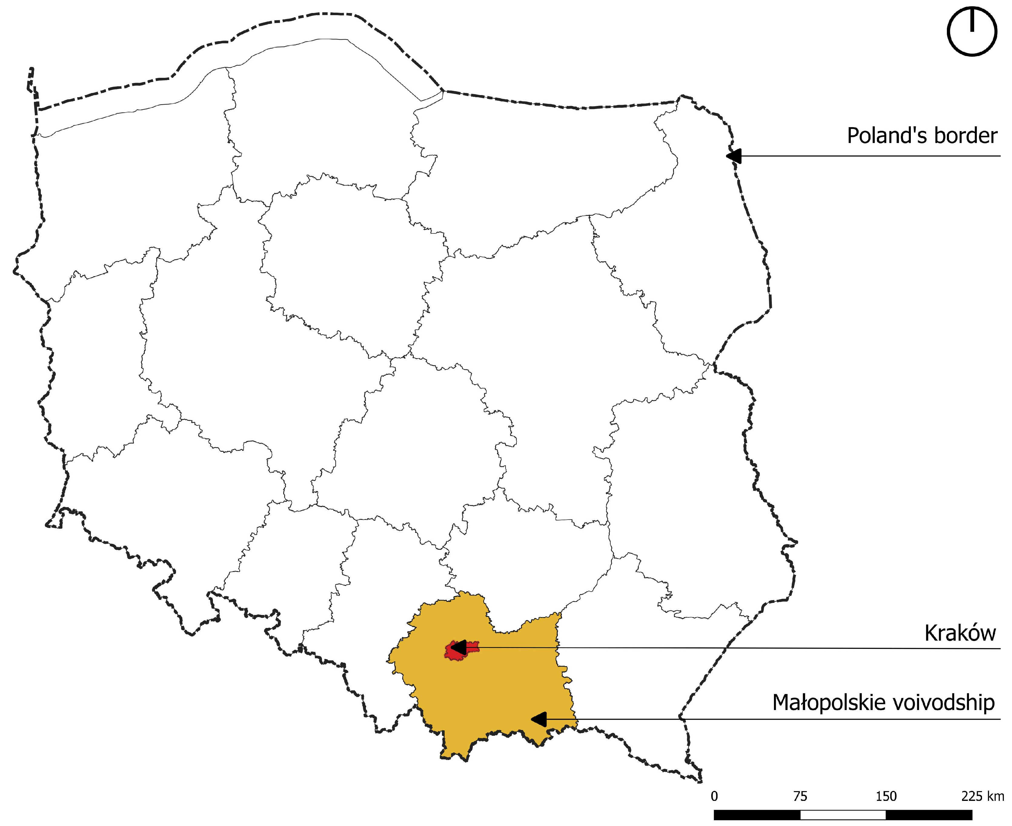
Krakow, with a population of over 800,000, is one of the largest cities in Poland. It is located in the southern part of the country, in the Lesser Poland Voivodship (Figure 3). Its area is 326.85 km2. In contrast to some of Poland’s large and medium-sized cities, the number of inhabitants is not declining; on the contrary, Krakow is still developing and its population is growing [69]. As the number of inhabitants increases, new development areas are identified and gradually built up, contributing to the overall urbanization of the city area. In this context, managing urban development in a way that does not endanger green areas is a major challenge that decision-makers need to address. According to the documents, Krakow has adopted a strategy for the development of green areas in order to improve their availability for residents, maximize ecological resilience, and promote biodiversity. The strategy is based on the city’s specific natural and functional conditions, such as its location in the Vistula River valley, its diverse topography, and different types of land cover. It aims to implement a mixed network model, which in this case means integrating existing green areas with green corridors and alleys. It is stated that the existing river parks, especially the Vistula River, play a crucial role in this model, serving as ecological corridors and recreational links between other green areas and parks, as well as between the city and the region [70].
According to the book by Zachariasz on the typology, history, and development of green spaces in Krakow [71], the interconnected green corridors, consisting of pedestrian and cycle paths and alleys, should form the core of the city’s green infrastructure. These linear green spaces are also important recreational spaces, providing opportunities for activities such as walking, cycling, and jogging. They also promote tourism by increasing the attractiveness of the city. In addition, in line with existing research on green space networks, the creation of a continuous system of green spaces in Krakow will provide significant ecological benefits, as these green corridors also serve as ecological corridors.
The contemporary system of green spaces in Krakow has been shaped over the centuries of the city’s urban development; therefore, it is complex and includes some elements of unique historical and cultural value, such as the Błonia public meadow, dating back to the Middle Ages, or Planty, one of the first public parks created in the 19th century on the site of the former medieval city walls [72]. Furthermore, greenery associated with military objects from the early 20th century, when Krakow served as an Austro-Hungarian fortress, plays an important role in the overall system [73,74]. It was carefully planned and positioned within and around the city to form a defense. Nowadays, the green spaces around former forts and smaller military buildings can be used and transformed into public parks, but this process is still ongoing and only a few forts have been revitalized.
This system is complex, not only in terms of historical heritage, composition, and landscape values, but also spatially and legally. There are several types of ownership, including private, municipal, state, or mixed, that can own green spaces, and some of the land may have an unregulated status. In order to efficiently manage and increase the amount of green space, the municipality needs to take steps to acquire the land and secure its future use [75]. In addition, there are several other challenges common to green space management in Poland, as noted by Feltynowski et al. These include inconsistent databases that operate with different measures, scales, types of green spaces, and sampling techniques, leading to inconsistent results of analyses and audits [76].
Consequently, a clear picture of the current situation in terms of the presence of green spaces and their formal status cannot be obtained from a single entity, and detailed studies and surveys need to be carried out for research purposes.

3.2. Selection of Parks and Green Areas

The study was carried out in the city of Krakow within its administrative boundaries; therefore, several institutions could provide data and information. Basic spatial data on the topography and green cover of Krakow were obtained from the Polish Geoportal website [77]. It is an online platform providing access to geospatial data and services related to the territory of Poland. The platform is operated by the Central Office of Geodesy and Cartography in Poland and provides various tools for searching, viewing, and analyzing geospatial data, including topographic maps, aerial photographs, land use, and administrative boundaries. Information on park status and management was taken from the Municipal Greenery. This is the local government body responsible for various tasks related to greenery, such as the maintenance of green areas, mostly parks and forests established on municipal land, and the management of their development. Finally, the Municipality of Krakow served as a source of additional information and geospatial data on the size and boundaries of the park.
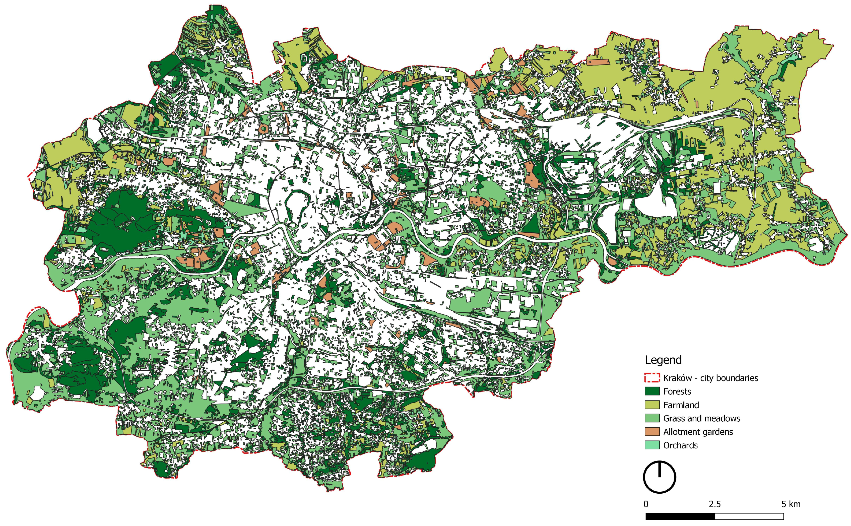
Initially, due to the lack of consistent data concerning the green areas, the area of the city was surveyed, and the total amount of existing green space was identified on the topographic map. The result of this assessment showed that there are several types and sizes of urban green spaces in Krakow, including forests, meadows, parks, allotments, and former and existing farmland, which contribute to the total amount of green space in the city (Figure 4). This, however, does not correspond fully with the amount of greenery that is accessible for residents and offers recreational opportunities or allows for socializing.
For this purpose, a selection of green areas had to be made. Firstly, based on previous research, it was assumed that in order to serve the community, green spaces must be open, accessible, and free of charge. Therefore, private green spaces such as allotments, orchards, and farmland were excluded from the dataset, as were green spaces owned by museums, monasteries, and churches. Next, the formal status of the green space was taken into account. This is an important factor, especially in post-socialist Poland, where there is a limited range of legal instruments to protect existing urban green spaces from development. According to Polish law, the most effective form of protection is through local land use plans, where land can be designated for public green space.
However, these plans are fragmented and do not cover the whole city, and hence cannot serve as a reliable and complete source of information. This is part of a wider problem of evasion of spatial planning law in Poland, which has consequences in many areas, such as a lack of spatial order, fragmentation of development areas, or excessive supply of building land [78]. Therefore, for the purpose of the research, a certain assumption had to be made that would allow for selecting the most appropriate green areas. It was assumed that most of the urban green spaces managed by the Municipal Greenery are considered public parks, and therefore their status is legally secured.
Finally, 55 public urban green spaces of different types were selected, all of which have the status of formal green space. The location and boundaries of each park were marked on the topographical map of Krakow (Figure 5). The areas range from less than 1 ha to almost 400 ha. The following table shows the basic parameters of the selected green spaces. Each of them has been assigned a random number (1–55), which serves as its symbol in the network and will be used further in the study (Table 1).

3.3. Network and Graph

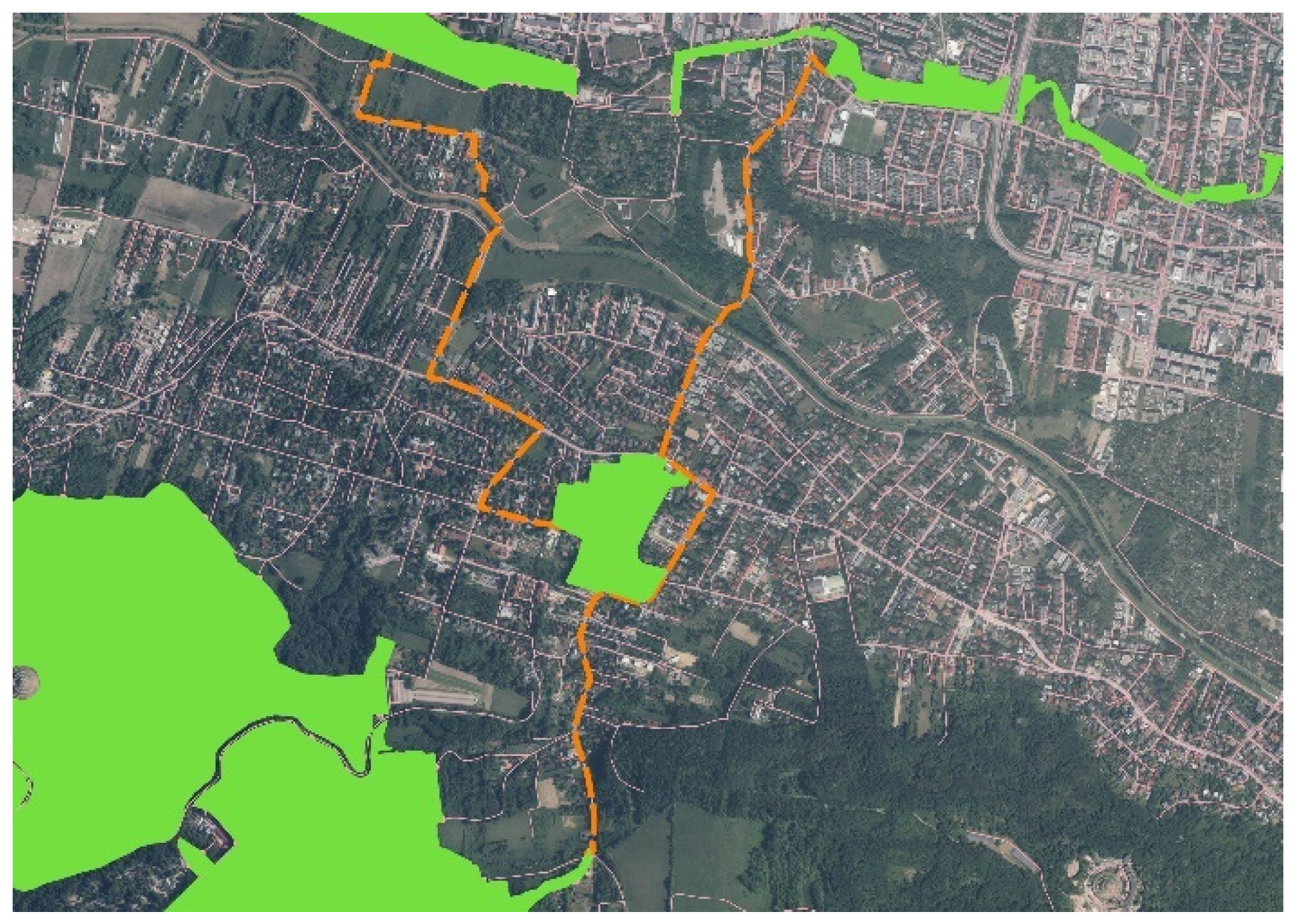
The process of network modelling and further network analysis required conversion of the spatial data into a format suitable for importing to the network visualization software. The selected 55 parks will act as nodes in the network that will be constructed later in the study. The next required step was to identify the links between the nodes (edges). The existing, real spatial connections between green spaces can be visualized as the lines of roads and footpaths that allow access from one green space to another (Figure 6). This is the most direct and straightforward way to measure connections within the existing road network and is commonly utilized in research and in the field of urban studies. As mentioned earlier, the roads are naturally treated as edges connecting intersections of the roads (nodes). However, this approach has its limitations, as it focuses only on the existing street pattern, ignoring its condition and congestion, which may limit its attractiveness for pedestrians [79]. As there are many tools to conceptualize accessibility, for example, through the size of catchment areas or potential accessibility zones, there is no agreement on which method provides the most reliable results [80]. For the purposes of the study, buffer zones were used as a simple proximity measure that allows the areas of good and very good accessibility around each park to be assessed.
First, a 100 m buffer was used, as it defines the threshold distance of closest proximity and allows us to identify the strongest spatial connections between green areas. The next buffer, 300 m, was used to assess the most convenient walking distance. It has been reported that the use of green spaces decreases after this distance [81]. However, other research shows that people are willing to travel longer distances to a selected park if the park meets their needs or provides recreational opportunities [82], so a 500 m buffer was used as the last buffer. This distance is still considered comfortable and the walking time at an average speed of 4 km/h is less than 8 min. Therefore, when constructing the network, it is assumed that it should be possible to move from one green space to another without exceeding the maximum distance of 500 m.
Next, the intersections of the buffers were determined and marked as points on the map (Figure 7). Each intersection between buffer lines was translated into an edge linking a pair of nodes. In cases where multiple intersections occurred, they were translated into an edge weight.
To visualize the network as a graph, the Gephi software (version 0.10.1) was used. The Force Atlas 2 algorithm in the Gephi software was used to calculate the spatial distribution of the nodes. The force-based algorithm starts with nodes randomly placed in the graph area and applies the forces of gravity and repulsion throughout the calculation process. This algorithm starts by placing nodes with stronger connections closer together and those with weaker connections further apart. When the graph is stabilized, edges tend to be of uniform length and nodes not connected by an edge are further apart, but the final position of nodes depends only on connections and no other variables are taken into account [83]. Graphs drawn using these algorithms tend to have aesthetically pleasing and symmetrical layouts that allow visual interpretation of different types of data [84], so it was reasonable to choose them for the purpose of network representation.

3.4. Centrality Measures

In this study, four main centrality measures were calculated for the network of green areas. These are degree, closeness, betweenness, and eigenvector centrality. The simplest is degree centrality (DC), which calculates the number of connections a particular location or node has to other nodes in the network. It is one of the easiest to calculate as it is simply the number of edges the node has. The higher the degree index, the more central the node is in the network. According to Golbeck, this can be a very useful metric, as nodes with high degrees tend to have high centrality scores based on other metrics as well [85]. In this case, weighted degree centrality, a variation of degree centrality, was used. According to recent findings in network research, it is useful to use edge weights when studying urban networks, as it allows us, for example, to capture the frequency of connections between locations [86].
The next basic measure is the closeness centrality (CC), which calculates the importance of nodes based on the average distance (expressed in terms of the number of connections, not geographical distance) between a given node and all other nodes in the network. Specifically, it is the inverse of the average shortest distance between the node and all other nodes in the network. The formula is 1/(average distance to all other nodes). The inverse is used so that a higher closeness centrality indicates a more desirable centrality score (i.e., a shorter average distance to other vertices). High closeness values indicate that nodes are close to other nodes in the graph [16,85].
The next measure is the betweenness centrality (BC), which calculates the number of times that a given location or node is located on the shortest path between other nodes. In other words, betweenness is a measure of the importance of a node in the flow of information or goods through the network. It can show different values from degree centrality, as nodes with very few connections can be positioned as ‘bridges’ between other nodes and have a high betweenness score [87].
Eigenvector centrality (EC) is used to measure the influence of a particular node based on the strength of its connections to other highly connected nodes. The eigenvector is calculated using complex formulae, but the operating principle is rather intuitive. As described by Hansen et al., it assumes that connections from nodes that are considered significant based on degree centrality measures carry more weight than connections from insignificant nodes [16].
Next, to assess the possible inequalities in the distribution of the centrality measures among the nodes of the network, the Gini coefficient is used to describe the trend. The Gini coefficient is a statistical measure commonly used to assess the distribution of a particular resource (such as income) among individuals in a given group. It ranges from a minimum of 0 (representing perfect equality) to a maximum of 1 (representing perfect inequality). In perfect inequality, resources or goods are concentrated in the hands of a few individuals or groups, while the rest have none, while in perfect equality.
The Gini coefficient is mostly used in the field of economics, but it can be used in different contexts to characterize the degree of equality in the distribution of resources and even centrality measures. This approach has been tested in studies by Crucitti et al. [55], who used the Gini coefficient to analyze street patterns and their centrality measures in 18 different cities, and by Kabisch and Haase [42], who assessed the spatial distribution of green spaces within urban clusters. In both cases, the Gini coefficient was found to be a valuable tool for assessing inequalities and helped to summarize the findings.
Finally, a compound centrality index was applied to the network in an attempt to test the usefulness and applicability of the single measure in the interpretation and comparison of the results with actual strategies towards green areas.

3.5. Mapping Centralities

Although centrality metrics provide new perspectives on the performance of the green network, it was necessary to present them in a spatial context, according to the aims of the study. Graphs are generated by mathematical algorithms and therefore have their own spatial logic, and the position of the node does not reflect the real geographical position of the park in the city. Therefore, the usability of the graphs as a tool for practitioners and urban planners may be limited by a lack of understanding of the nature of the network representation. To avoid that, the results of single centralities, as well as the results of the compound centrality index, were assigned to a green area network and presented on the map of Kraków.

4. Results

This section presents the results of the network and centrality analysis. First, the general properties of the graph are discussed, and four centrality measures are presented. In each case, the highest values for the nodes are presented in a table. Next, the results are transferred to the map of Krakow, and the parks with the highest and lowest centrality values are identified. Finally, the results of the centrality measures are compared and discussed with regards to the spatial context of studied parks.

4.1. Network and Graph Results

The network constructed in this study consists of 55 nodes and 78 edges. Each node represents one public park in Kraków, and the edges represent the intersections between the successive accessibility buffers of 100, 300, and 500 m. The edges are weighted, which means that the number of connections between two nodes is proportional to the width of the edge. When certain green areas are close together, their buffer zones may intersect many times, resulting in more connections being attached to them. Because of this characteristic, the edge weight is the most helpful in interpreting the degree centrality (DC), which is simply based on the number of links.
The results of each centrality calculation are presented in the graphs (Figure 8). The geometry of the graph is the same in each case. The basic parameters of the network are as follows. The network diameter is 12, which is the longest of all calculated shortest paths in a network. Next, the graph density was calculated, and this formula indicates how many edges are between nodes in relation to the largest possible number of edges. In other words, the graph density shows how connected the network currently is and how connected it could be. The values for a simple, undirected graph range from 0 for a graph with no edges to 1 for a graph with the maximum number of connections [85]. In this case, the graph density is 0.053, indicating a moderate level of overall connectivity.
This result can give us some initial information about the network properties. Based on the graph density, we can assume that either the network consists mostly of moderately connected nodes, or it consists of several well-connected nodes with the rest being poorly connected. However, to obtain more precise information, the several centrality measures need to be calculated and analyzed.
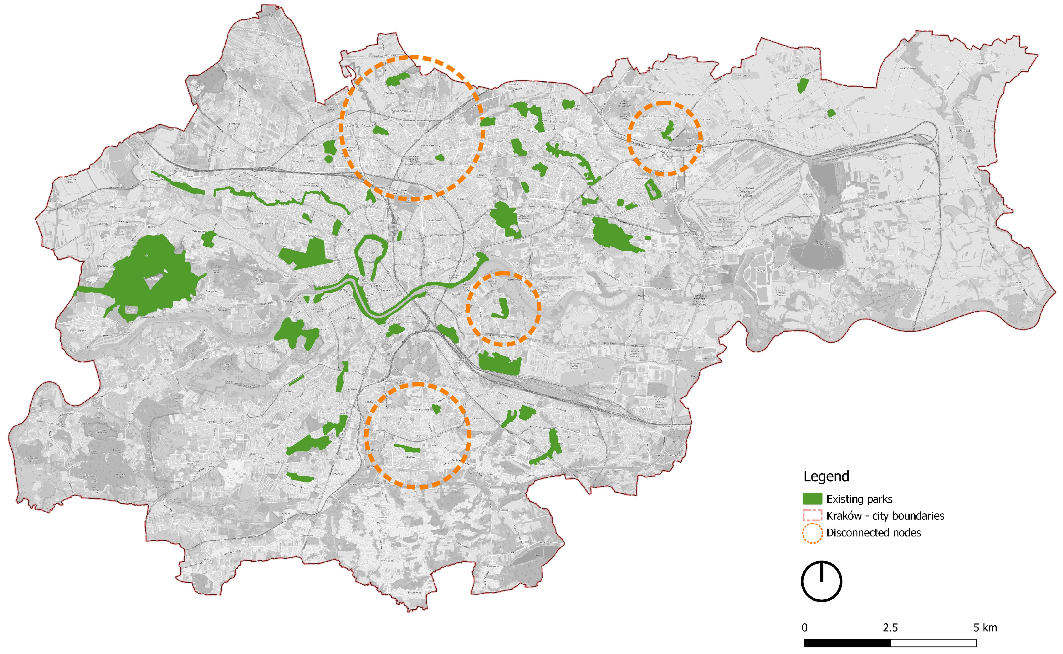
Therefore, the next step included calculating and visualizing the results of each centrality (DC, CC, BC, EC). The final graph shows that for each centrality, there are several nodes with high and very high measures, but their distribution varies between graphs (Figure 8). The size of the nodes in the graph represents the proportions of the centrality measures. The largest nodes represent the parks with the highest centralities. The graph also shows that several nodes are disconnected from the network, with zero edges attached to them. They have the smallest diameter and are located at the periphery of the graph. These nodes are 8 (Park Duchacki), 18 (Park Kurdwanów), 20 (Park Zaczarowanej Dorożki), 21 (Park Kościuszki), 31 (Park Witkowicki), 41 (Park Zielony Jar Wandy), and 52 (Park Ogród Płaszów). According to the adopted method of determining the edges, these parks do not have any other green areas within the maximum comfortable walking distance.
In the case of disconnected nodes, all of the following centrality metrics are equal to zero. In theory, as they do not contribute to the studied network, they can be removed. Nevertheless, it was considered useful not to exclude these parks from further analysis and not to remove them from the graph. The information on the disconnected nodes is important for obtaining the full picture of the analyzed network. The geographical position of the disconnected parks will be discussed further in the study when the results of the centrality calculations are placed in the spatial context of Kraków.

4.2. Centrality Results

The results of the centrality calculations are presented in two steps. First, the results of single centralities, namely degree (DC), closeness (CC), betweenness (BC), and eigenvector (EC), are discussed, and then the compound centrality index (DBE) is calculated as a key outcome at this stage of the research.

4.2.1. Single Centrality Measures

The results of the DC range from 0 for the unconnected nodes to over 240 for the most connected nodes, with the mean and standard deviation values indicating a rather high degree of variability. The highest value (248) in this case is given to node number 53 (Bulwary Wisły River Park), the next value is 148 for node number 38 (Łąki Nowohuckie), and 120 for node number 13 (Park Ratuszowy). The results indicate that these places have the largest number of potential connections within their buffer zones. Additionally, it can be assumed that they are in relatively close distances, as the furthest buffer zone is 500 m. Hence, the degree centrality can be interpreted as the reference value that shows the basic connectivity within the network nodes.
Next was the closeness centrality measure (CC), which ranges between 0 and 1 with mean value x ¯ = 0.27568 and standard deviation s = 0.25104. Again, the lowest value was for the unconnected nodes, but the highest values were observed in different nodes, not in those with the largest number of connections (highest DC values). In fact, it is the pairs or small clusters of nodes with a low degree of DC that have the highest values. The CC values show variability, with only four nodes reaching the highest value possible, and the majority of nodes ranging between 0.3 and 0.1. The highest values (1) were achieved by nodes number 12, 48, 25, 34, the next value of 0.75 was assigned to nodes number 54 and 49, and finally 0.5 was assigned to nodes number 4 and 47. Interestingly, the next highest value was for node number 53 (0.32), which shows its relative importance in this type of centrality. However, this interpretation is only a rough approximation based on the comparison of the top ten results. The existing studies on urban networks do not discuss the properties of proximity centrality, although they tend to use it together with other centralities [65,88]. Therefore, this measure requires more testing on the other types and sizes of networks.
The betweenness centrality (BC) results show 0 as the lowest value and over 500 as the highest, with a mean x ¯ = 54.52727 and a standard deviation s = 104.39270. In this case, the results showed significant differences. The 10 highest scores ranged from 517.87 to 110. In addition to the disconnected nodes, there are also 17 nodes that received a zero, meaning that they were never on the path connecting other nodes and are positioned on the edges of the network. These results suggest that nodes with the highest scores can act as ‘bridges’ between other nodes, allowing pedestrian flows. This means that people wishing to travel from one green space to another within a network may choose the shortest route through the parks with high BC values due to their convenient location. There is an open debate among researchers as to whether betweenness centrality can be used to predict pedestrian flows. Some argue that distance is not the most important factor when making route decisions, and that various factors such as facilities and shops need to be taken into account [89,90]. However, according to others, the betweenness centrality can give valuable information on the shortest paths within the network, especially when used together with other centrality measures [65].
And finally, the results of the eigenvector centrality (EC) were calculated and range between 0 and 1, with the majority of the results below 0.5, as indicated by the relatively low mean value ( x ¯ = 0.27188). The visual distribution of medium and high EC scores on the graph shows similarities when compared to the distribution of DC scores. The highest value (1) was assigned to node 53 (Bulwary Wisły River Park), and the next values are 0.96 for node 22 (Błonia Krakowskie) and 0.83 for node 42 (Planty Krakowskie). The following table shows the 10 highest values of each centrality (Table 2). It can be observed that nodes with high values of DC tend to have high values of EC as well. This can be explained based on the nature of eigenvector centrality, which calculates the direct connections, but also the indirect connections of every node. The main difference between eigenvector and degree centrality is that eigenvector weights contacts according to their degree centrality [62]. Therefore, it takes into account the connection of the whole network. According to Pearson’s correlation, the results of DC and EC show a strong positive correlation, r(53) = 0.8769, p < 0.05, which confirms the initial observations.
In the case of BC, this tendency to follow the DC results is not visible, and the calculated correlation is weak (r = 0.4647, p < 0.05), but the highest value for node 53 is consistent with the DC and EC results, which confirms the initial assumption that the basic centralities reach relatively high values for the well-connected (in terms of DC results) nodes. Finally, of the four centralities, the CC results show the least consistency with the other three centralities, with the highest values for nodes with low and very low DC values. The correlation of the results is r(53) = −0.0399, p = 0.78, meaning that there is no linear relationship between the DC and CC values.
As the results of the centrality calculations vary in each case, the Gini coefficient was used. Borrowed from the economic studies, the Gini coefficient can show the equity of distribution of a value within a certain group. The results of the Gini coefficient calculations indicate that there is an imbalance in the distribution of centrality scores between the parks, with the greatest inequality observed in BC scores (almost 0.8). Together with other parameters, the Gini coefficient quantitatively characterizes the degree of equality in the distribution of single centrality measures and indicates the presence of dominating nodes, with very high centrality values and nodes with very low results, which contribute to the uneven distribution (Table 3).
Of the four centralities studied, the degree centrality was the simplest and most intuitive measure. Accordingly, eigenvector and betweenness centralities provided interesting results; however, the closeness centrality in the case of the network studied produced counterintuitive results that were difficult to interpret, so it was excluded from further study. However, it is possible that the results may be different when considering a larger or more complex network, so the use of closeness centrality in urban geographical space requires further study.
Consequently, it was found that modelling and analyzing the network revealed data-based properties of the network of public parks and forests of Kraków. In addition, centrality measures applied to a network of green spaces can become a useful tool for identifying nodes of key importance and those that lack connectivity.

4.2.2. Compound Centrality Index

Results show that different nodes can become important elements of the network, depending on the applied criteria and centrality algorithms. Although single centrality measures provide valuable information on the importance of particular parks in terms of the connectivity, there is a need for a single, unified measure that can operationalize the centrality calculations for the purposes of urban analysis and provide comparable information about the position of each park.
For this purpose, the compound centrality index was introduced, and it was calculated as the mean value of the degree, betweenness, and eigenvector centralities (DBE). This index was used to indicate parks with high overall centrality as well as those with low centrality. At this point, the CC results were excluded from the formula, due to the contradictory results.
The DBE values also vary, with a maximum of 255.622 (node 53) and a minimum of 0 for the disconnected nodes (Table 4), with most of the results in the range between 1 and 50. The mean is 36.884 and the standard deviation is 44.545, indicating a relatively high degree of variation. In fact, the jump in values within the top 12 results is quite high (from 56 to almost 256), which, based on the graph properties alone, can be interpreted as a situation where a very strong and well-connected node dominates the network.
The Gini coefficient was also calculated for the DBE and the result is 0.55790, showing that the distribution of the compound index also varies according to the individual centralities (Table 5). In addition, the inequality of the distribution confirms the previous observation that this particular network, instead of having many nodes with average centrality, consists of several nodes with very high centrality, as well as a few nodes with very low centrality, and that the results are unevenly distributed.

4.3. Centrality Distribution in Krakow

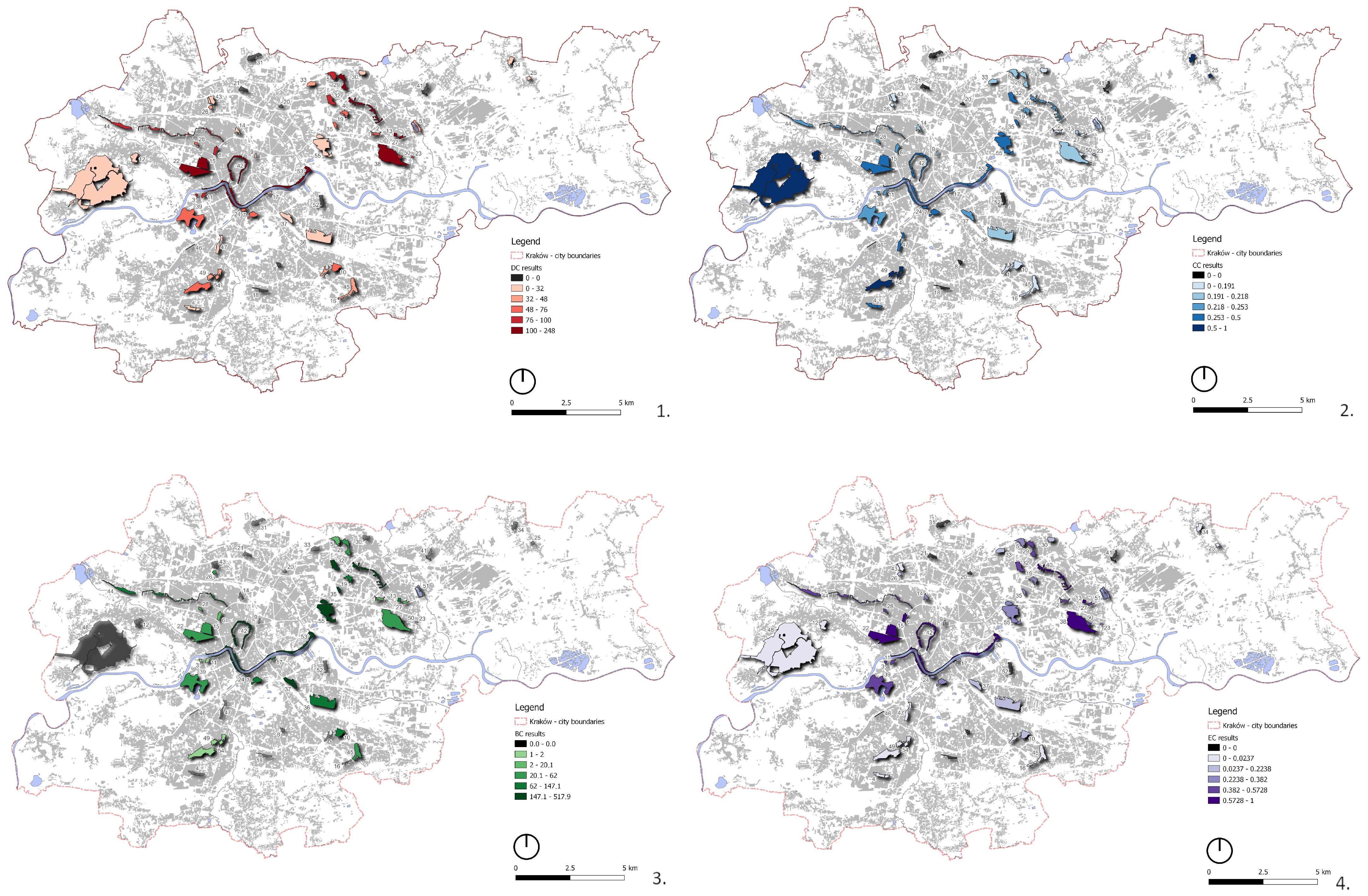
The centrality results were then transferred to the map of Krakow and assigned to the existing green areas (Figure 9). The equal number (quantile) classification method is used to describe the distribution according to the centrality values for each park.
In each case, the disconnected nodes (centrality values equal to zero) are marked in black. Figure 10 shows the geographical location of these parks in Kraków. They are located in different parts of the city, not necessarily in the most peripheral areas. However, they share the common characteristic of not being within walking distance of each other or of other green areas forming the network. According to the method adopted, based on the buffer zones of 100, 300, and 500 m, the maximum distance that guaranteed the connection between the nodes was 1000 m. In this case, the connection would be considered weak, as only the most distant buffer zones intersect. This distance exceeds the comfortable walking distance; however, there is no agreement on green area accessibility standards, so even the distances of 1 km up to 5 km are considered in the research [33].
Simple visual comparison of the results confirms that the centrality measures vary greatly between parks. First, the degree centrality (DC) was analyzed. It was found to be the most useful and easy to apply, as it allows for a quick evaluation of connections of each park. In this case, the connections between nodes are derived from the proximity buffers, so the DC can reflect the real spatial relationships and distances within the network. It was also the most intuitive measure, which may be important when incorporating this tool into decision-making processes, especially when it comes to green area management [75]. The DC displayed the highest values for the parks located in the central area of the city, including those located in the historical districts, for example, Bulwary Wisły, Planty Krakowskie, Park Jordana, and Błonia (nodes number 53, 42, 15, 22). At the same time, very high values were achieved by parks located in the northeastern part of the city, in the area dominated by socialist mass-housing estates. Parks with high connectivity include Łąki Nowohuckie, Park Ratuszowy, Planty Bieńczyckie, Park Szwedzki, and Planty Mistrzejowickie (nodes number 38, 13, 40, 27, 29).
The eigenvector centrality (EC) has the potential to support the degree centrality as it shows similar values. In addition, it allows us to identify the nodes that are well-connected not only locally, but also taking into account the connections of their neighbors, [62]. Again, a very high value was achieved by Bulwary Wisły, which is a linear river park going through the city center and well-connected with other centrally located green areas, such as Błonia or Park Krakowski.
The betweenness centrality (BC) shows a similar trend, but a large number of nodes have very low values. These are specifically parks on the periphery of the network, which, due to their geographical location, could not act as ‘bridges’ between other green areas, meaning that there are no other parks between them and the border of the city. For example, it is park Fort Mistrzejowice (node number 30) that is directly connected only to Planty Mistrzejowickie (node 29). It can be hypothesized that when considering a larger network, for example, including neighboring municipalities, these nodes may have different, more central values.
Conversely, closeness centrality (CC) did not provide the meaningful results expected at the beginning of the research. The highest CC measures were assigned to nodes with low or very low other metrics (DC, BC, EC). This result does not follow the general interpretation of the CC algorithm, which is supposed to produce high values for the well-connected nodes [85]. The explanation for this result can be found in a publication on network analysis by Wasserman and Faust. According to the authors, the closeness centrality reaches the highest values in the case of clusters of nodes that are strongly connected to each other and not connected or poorly connected to the rest of the nodes in the graph [91].
Following this explanation, the results of the CC calculation can be interpreted more precisely. The parks with high values form pairs or small clusters and are located relatively close to each other, but at the same time these clusters are not connected (too far away) to the rest of the network. Consequently, the network distances between nodes in clusters are calculated as being the strongest. This information is important for verifying the applicability of centralities, which is one of the aims of the study. It shows that closeness centrality must be used carefully and should not be used as a stand-alone indicator of network properties.
Finally, the DBE values were projected onto the map of the city (Figure 11). Parks with the highest DBE values (over 56) tend to be concentrated in the northern part of the city, forming a strip from west to east. The parks in the southern part of the city generally have lower values, and the lowest values were achieved by parks located further away from the main strip; however, in this case, no strong tendency is visible. The map also shows the elements of the current green space management strategy (KZiRTZ), with the green corridors designed to connect parks and other green spaces with pedestrian paths and green avenues supporting the system of connections. However, it is clear that these green avenues provide connections within areas that are already well-connected, with high centrality metrics, while the poorly connected areas still lack additional connections.
Furthermore, the mapping of centralities showed the position of the highest results of DBE index. It can be observed that these were achieved, among others, by linear river parks such as Bulwary Wisły and Młynówka Królewska. This finding directly supports the City Strategy for the Directions of Development and Management of Green Spaces in Krakow for 2019–2030 [70], where the river parks are mentioned as important connectors of the system of green areas.
In particular, the strongest position within the network is held by the Bulwary Wisły River Park (Node 53), which shows the best potential for multiple spatial connections within its buffer zones. In addition, its geographical location in the central part of the city and its length work to its advantage, as this park is surrounded by many other green areas within relatively short distances, which enhances its connectivity. Additionally, other linear structures, namely “Planty”, tend to have high DBE values. These are parks Planty Bieńczyckie (node 40) and Planty Krakowskie (node 42). It can therefore be assumed that the typology of the park plays a role in its connectivity and importance in the network, and that linear forms can be particularly valuable for the network of urban green spaces.
Parks with low DBE index values tend to be further away from the city center and other green areas; however, not all of them are located on peripheries of the city.
It may be interesting to note that parks in the eastern part of the city (Nowa Huta district) have relatively high DBE values. This part was planned and built during the socialist period, when the central government decided on the development of cities and districts [92]. Although the period of state socialism left Poland in a very poor economic condition, the mass-housing estates built during this period are recently attracting more attention due to their unique advantages such as urban composition, presence of social space, and other amenities that can meet contemporary needs. Housing planned and built between the 1950s and 1980s was accompanied by public roads, parks, and other forms of public greenery, which are still functioning today [93,94]. The plans included population projections for each housing unit, as well as the use of accessibility buffers for planned amenities, including green spaces. This phenomenon can explain the strong interconnections within the network of parks observed in the results.

5. Conclusions and Discussion

This was a pilot study to test the usefulness of centrality measures in the real geographical space of Krakow. Centralities were calculated for the network of existing public parks, which served as nodes, while connections were simulated using proximity buffers. The research that has been carried out has led to the formulation of several conclusions, which can be divided into two main areas. The first one considers the usefulness of the centrality measures that were put to the test in this study and the second one considers the characteristics of the particular network that was studied based on the public parks of Kraków.
The main questions that motivated the undertaking of the research considered the usefulness and potential for applicability of centrality measures, and the research allowed for formulating the answer. Indeed, testing the single centrality (degree, betweenness, closeness, and eigenvector) as well as compound centrality index in the real geographical space of Krakow provided interesting insights into the relationships, importance, and patterns of connectivity within the constructed network. In particular, this study confirmed that centralities can be applied to urban systems other than transport networks and demonstrated the importance of various green areas according to the centrality algorithm.
Having said that, it is possible to implement the centrality approach into various stages of managing the green areas. Firstly, the network centralities can provide additional information for the experts and professionals in the process of analysis. Secondly, it can be used as a tool for testing possible spatial scenarios. For example, when considering land acquisition for the purpose of public greenery, centralities can be used to optimize the location or size of the new park to improve the network parameters. This particular property of network analysis was also used in a study by Wu et al., who used it as a part of a workflow to simulate and analyze the urban spatial structure of Singapore according to different urban policy scenarios [95]. Although this study was of a theoretical nature, it proved that the network analysis and centrality approach can be implemented at various stages of managing urban development.
The results of single centralities provided meaningful results that could be further interpreted and compared; however, it is the compound centrality index that helped summarize the centralities and allowed for comparing the results with the current strategy towards green areas. According to this index, it was possible to indicate parks that are more important in the network due to the typology, location, and proximity of other green areas, and that those parks form a clear and well-connected core of the existing system.
Other advantages of the centrality identified throughout the study include the direct possibility of presenting the results on the graphs. This simplification was found particularly useful in determining the position of each analyzed park in relation to the rest of the network. This finding is consistent with other studies incorporating graph theory in the urban context. For example, Liu et al. states that it was found useful that graph theory simplified the complex real landscape and allows for quick comparison of metrics [13]. Butts concludes precisely that “its (…) the reductive nature of graphical structure that has facilitated its rich mathematical development and associated scientific applications (…)” [96]. Consequently, through simplification, graphs can be useful in conceptualizing various, not only spatial, relationships among green areas and potentially other elements of the city.
The ability to implement the results of the measures in GIS-based analysis is an additional advantage, as it can help to combine the data-driven approach with one based on design, composition, and visual qualities. GIS is often used in the early stages of research as it allows for accurate spatial data acquisition and preparation [41,97]. Yet, in this case, the use of GIS after the network analysis helped us to visualize the centrality results and the compound centrality index in relation to the size, shape, and location of each park in Kraków. Linking the abstract network model with georeferenced data is perceived as a challenge, but also an important component of research rooted in urban conditions, as stated, for example, by Agryzkov, who made the effort to incorporate the spatial data of points of interest (mainly shops and bars) into the proposed algorithm of eigenvector centrality [64]. In this study, mapping the results was also an important step towards the formulation of recommendations for improvements.
In addition, the presented workflow is relatively straightforward and therefore allows for quick application. This finding is particularly important for practical reasons. GIS tools and GIS-based spatial resources are commonly used by municipalities, and it is expected that the results of centrality calculations, in particular the compound centrality index, can be implemented in the urban analysis of green areas, leading to future improvements of this system in Kraków. This finding can be supported, for example, by the study by Wolff, who compared several methods of assessing green space accessibility in Halle, Germany, and suggests that network analysis has the potential to help in proper management and monitoring [98].
Finally, it should be noted that individual centralities and even the compound centrality index cannot serve as a stand-alone tool for urban policy, as it does not have the capacity for other types of variables and information, such as park quality, equipment, or precise location data. The results provided by either the centralities or the compound index need to be approached with consideration and respect for local conditions. In this context, centralities can be treated as a complementary tool for green space management and planning, used together with qualitative analysis, population data, and in situ observations. Similar observations can be found in a study by Pérez-Campaña et al., who used the multiple centralities to identify unused and abandoned places in the outskirts of Granda that could be further revitalized. They concluded “(…) centrality approach does not have to be considered as a definitive tool, rather a way of providing new information to be related to other factors with the aim of offering solution endurance (…)” [68].
The implications of the research include providing scientific evidence on the properties and connectivity of the network and particular nodes. It has the potential to guide policy and urban planning towards green areas that can be used in the urban analysis and planning process together with other types of analysis, thus complementing the traditional design-based approach.
Accordingly, recommendations for the future policy towards green areas can be formulated. The current strategy towards green areas does not undertake the problem of network connectivity; therefore, the existing and planned connecting elements (green corridors and avenues) tend to concentrate around areas with high centrality values and skip the poorly connected ones. To improve the current situation, either new public green areas should be created or the existing ones extended to allow for better accessibility. There is a strong need to integrate the parks that were indicated as disconnected into the system of public greenery. The presented approach can also help identify key locations for establishing new green spaces or optimizing the existing ones to maximize their positive impacts on the urban ecosystem and community health.

6. Study Limitations and Further Research

The value of this study lies in highlighting the concept of centrality measures as a tool for understanding and analyzing the importance of different nodes within an urban network; however, due to the exploratory nature of this study, several limitations can be identified, either due to the methodology used or the case selected. Firstly, the mathematical approach to the configuration of green spaces was of primary importance, with less attention paid to the other conditions of the parks. Although this was intentional, in order to focus on the results of the centrality calculations, it would be beneficial to incorporate more characteristics such as the design quality of the green space or its size. In the process of planning and managing green spaces, these characteristics also play an important role and should be taken into account [99,100].
There is also a need to consider the influence of topology, which strongly influences the possibility of creating pedestrian connections. For example, there might exist spatial obstacles of natural or man-made nature such as altitude differences, rivers, highways, railway lines, or different development types that hinder the accessibility and lower the connectivity of area [101]. Drawing from the present study, this issue can be addressed in the future by refining the method of assessing network connections and including more spatial data.
The inconsistency of spatial data on green spaces was another limitation to the accuracy of the results. The first steps of the study involved comparing data from different sources. It was found, for example, that the boundaries of parks varied widely between documents, and that determining formal status and management required multiple analyses. This is, however, a common problem reported by Polish researchers, particularly those working on green spaces. Feltynowski et al. provided an in-depth study of challenges and barriers in the management of urban green areas related to a lack of cooperation between institutions, and therefore a lack of coordination in the information provided [76]. At the same time, Wysmułek et al. suggested in their research that “the more consistent approach to green space qualification could prove helpful for reporting purposes across the European Union—in particularly the unification of green space terminology and the approach to private, semi-private and open spaces” [40].
Finally, the issue of boundaries needs to be addressed. For the best results, the network analysis could be carried out at different scales and the existing network of urban green spaces could be extended to peri-urban or even rural areas. The administrative boundaries of the city of Krakow were useful at this stage of the research when the method was tested. However, as shown by Gil, edges of the network can influence and alter the centrality results, for example, by positioning the node as the last one on the path [102]. Consequently, it would be of great social and environmental benefit to extend the studied network to neighboring municipalities. For example, in the present study, there were parks located at the edges of the network that achieved low values of betweenness and eigenvector centrality due to their marginal position in the city. By extending the network, these parks can be re-positioned within the network and achieve better centrality results. It is also possible to include areas other than public parks as potential nodes, thus creating a network with different characteristics.
Highlighting the role of a green space network is particularly important for urban green space system planning, and by implementing a data-driven approach to analyzing the existing network connections, we can better understand the current situation and provide decision-makers with a framework for future planning and development. The aim of the graph theory approach presented in this study was to provide new perspectives to consider when working towards sustainable urban development.

Funding

This research received no external funding.

Institutional Review Board Statement

Not applicable.

Informed Consent Statement

Not applicable.

Data Availability Statement

Data supporting this study are included within the article.

Conflicts of Interest

The author declares no conflict of interest.

References

  1. Wolch, J.R.; Byrne, J.; Newell, J.P. Urban green space, public health, and environmental justice: The challenge of making cities “just green enough”. Landsc. Urban Plan. 2014, 125, 234–244. [Google Scholar] [CrossRef]
  2. Madureira, H.; Nunes, F.; Oliveira, J.V.; Cormier, L.; Madureira, T. Urban residents’ beliefs concerning green space benefits in four cities in France and Portugal. Urban For. Urban Green. 2015, 14, 56–64. [Google Scholar] [CrossRef]
  3. Ekkel, E.D.; de Vries, S. Nearby green space and human health: Evaluating accessibility metrics. Landsc. Urban Plan. 2017, 157, 214–220. [Google Scholar] [CrossRef]
  4. Garau, C.; Pavan, V.M. Evaluating Urban Quality: Indicators and Assessment Tools for Smart Sustainable Cities. Sustainability 2018, 10, 575. [Google Scholar] [CrossRef]
  5. Giedych, R.; Maksymiuk, G. Specific features of parks and their impact on regulation and cultural ecosystem services provision in Warsaw, Poland. Sustainability 2017, 9, 792. [Google Scholar] [CrossRef]
  6. Hwang, Y.H.; Nasution, I.K.; Amonkar, D.; Hahs, A. Urban green space distribution related to land values in fast-growing megacities, Mumbai and Jakarta-unexploited opportunities to increase access to greenery for the poor. Sustainability 2020, 12, 4982. [Google Scholar] [CrossRef]
  7. Ying, J.; Zhang, X.; Zhang, Y.; Bilan, S. Green infrastructure: Systematic literature review. Econ. Res. Istraz. 2022, 35, 343–366. [Google Scholar] [CrossRef]
  8. United Nations (Habitat III). New Urban Agenda; United Nations: Quito, Ecuador, 2017. [Google Scholar]
  9. World Health Organization. Urban Green Spaces: A Brief for Action; WHO: Geneva, Switzerland, 2017. [Google Scholar]
  10. Durkheim, E. Suicide. A Study in Sociology; Free Press: New York, NY, USA, 1951. [Google Scholar]
  11. Borgatti, S.P.; Mehra, A.; Brass, D.J.; Labianca, G. Network analysis in the social sciences. Science 2009, 323, 892–895. [Google Scholar] [CrossRef] [PubMed]
  12. Batty, M. New Science of Cities; MIT Press: Cambridge, MA, USA, 2013. [Google Scholar]
  13. Liu, W.; Hou, Q.; Xie, Z.; Mai, X. Urban network and regions in China: An analysis of daily migration with complex networks model. Sustainability 2020, 12, 3208. [Google Scholar] [CrossRef]
  14. Sharma, S.; Ram, S. Investigation of Road Network Connectivity and Accessibility in Less Accessible Airport Regions: The Case of India. Sustainability 2023, 15, 5747. [Google Scholar] [CrossRef]
  15. Porta, S.; Crucitti, P.; Latora, V. The network analysis of urban streets: A primal approach. Environ. Plan. B Plan. Des. 2006, 33, 705–725. [Google Scholar] [CrossRef]
  16. Hansen, D.L.; Shneiderman, B.; Smith, M.A.; Himelboim, I. Calculating and Visualizing Network Metrics; Elsevier: Amsterdam, The Netherlands, 2019; ISBN 9780128177563. [Google Scholar]
  17. Gialampoukidis, I.; Kalpakis, G.; Tsikrika, T.; Papadopoulos, S.; Vrochidis, S.; Kompatsiaris, I. Detection of terrorism-related twitter communities using centrality scores. In Proceedings of the MFSec 2017—Proceedings of the 2nd International Workshop on Multimedia Forensics and Security, co-located with ICMR 2017, Bucharest, Romania, 6 June 2017; pp. 21–25. [Google Scholar] [CrossRef]
  18. Gu, J.; Abroms, L.C.; Broniatowski, D.A.; Evans, W.D. An Investigation of Influential Users in the Promotion and Marketing of Heated Tobacco Products on Instagram: A Social Network Analysis. Int. J. Environ. Res. Public Health 2022, 19, 1686. [Google Scholar] [CrossRef] [PubMed]
  19. Kong, F.; Yin, H.; Nakagoshi, N.; Zong, Y. Urban green space network development for biodiversity conservation: Identification based on graph theory and gravity modeling. Landsc. Urban Plan. 2010, 95, 16–27. [Google Scholar] [CrossRef]
  20. Maes, J.; Zulian, G.; Günther, S.; Martijn, T.; Raynal, J. Enhancing Resilience of Urban Ecosyxstems throug Green Infrastructure (EnRoute); Office of the European Union: Luxembourg, 2019; ISBN 9789276002710. [Google Scholar]
  21. Mears, M.; Brindley, P.; Jorgensen, A.; Maheswaran, R. Population-level linkages between urban greenspace and health inequality: The case for using multiple indicators of neighbourhood greenspace. Health Place 2020, 62, 102284. [Google Scholar] [CrossRef] [PubMed]
  22. Hunter, M.C.R.; Gillespie, B.W.; Chen, S.Y.P. Urban nature experiences reduce stress in the context of daily life based on salivary biomarkers. Front. Psychol. 2019, 10, 1–16. [Google Scholar] [CrossRef] [PubMed]
  23. Li, Q. Effect of forest bathing trips on human immune function. Environ. Health Prev. Med. 2010, 15, 9–17. [Google Scholar] [CrossRef]
  24. Wang, R.; Helbich, M.; Yao, Y.; Zhang, J.; Liu, P.; Yuan, Y.; Liu, Y. Urban greenery and mental wellbeing in adults: Cross-sectional mediation analyses on multiple pathways across different greenery measures. Environ. Res. 2019, 176, 108535. [Google Scholar] [CrossRef] [PubMed]
  25. Maas, J.; Verheij, R.A.; Groenewegen, P.P.; De Vries, S.; Spreeuwenberg, P. Green space, urbanity, and health: How strong is the relation? J. Epidemiol. Community Health 2006, 60, 587–592. [Google Scholar] [CrossRef] [PubMed]
  26. Korpilo, S.; Kajosaari, A.; Rinne, T.; Hasanzadeh, K.; Raymond, C.M.; Kyttä, M. Coping with Crisis: Green Space Use in Helsinki Before and During the COVID-19 Pandemic. Front. Sustain. Cities 2021, 3, 1–13. [Google Scholar] [CrossRef]
  27. Kim, D.; Jin, J. Does happiness data say urban parks are worth it? Landsc. Urban Plan. 2018, 178, 1–11. [Google Scholar] [CrossRef]
  28. van den Berg, A.E.; Maas, J.; Verheij, R.A.; Groenewegen, P.P. Green space as a buffer between stressful life events and health. Soc. Sci. Med. 2010, 70, 1203–1210. [Google Scholar] [CrossRef] [PubMed]
  29. European Environmental Agency. Urban Green Infrastructure—Interactive Map. Available online: https://eea.maps.arcgis.com/apps/MapSeries/index.html?appid=42bf8cc04ebd49908534efde04c4eec8 (accessed on 4 October 2020).
  30. Kothencz, G.; Kolcsár, R.; Cabrera-Barona, P.; Szilassi, P. Urban Green Space Perception and Its Contribution to Well-Being. Int. J. Environ. Res. Public Health 2017, 14, 766. [Google Scholar] [CrossRef] [PubMed]
  31. Kaczynski, A.T.; Potwarka, L.R.; Saelens P, B.E. Association of park size, distance, and features with physical activity in neighborhood parks. Am. J. Public Health 2008, 98, 1451–1456. [Google Scholar] [CrossRef] [PubMed]
  32. Pereira, G.; Foster, S.; Martin, K.; Christian, H.; Boruff, B.J.; Knuiman, M.; Giles-Corti, B. The association between neighborhood greenness and cardiovascular disease: An observational study. BMC Public Health 2012, 12, 466. [Google Scholar] [CrossRef] [PubMed]
  33. Markevych, I.; Schoierer, J.; Hartig, T.; Chudnovsky, A.; Hystad, P.; Dzhambov, A.M.; de Vries, S.; Triguero-Mas, M.; Brauer, M.; Nieuwenhuijsen, M.J.; et al. Exploring pathways linking greenspace to health: Theoretical and methodological guidance. Environ. Res. 2017, 158, 301–317. [Google Scholar] [CrossRef]
  34. Sturiale, L.; Scuderi, A. The role of green infrastructures in urban planning for climate change adaptation. Climate 2019, 7, 119. [Google Scholar] [CrossRef]
  35. Giannakis, E.; Bruggeman, A.; Poulou, D.; Zoumides, C.; Eliades, M. Linear Parks along Urban Rivers: Perceptions of Thermal Comfort and Climate Change Adaptation in Cyprus. Sustainability 2016, 8, 1023. [Google Scholar] [CrossRef]
  36. Jarvis, I.; Gergel, S.; Koehoorn, M.; van den Bosch, M. Greenspace access does not correspond to nature exposure: Measures of urban natural space with implications for health research. Landsc. Urban Plan. 2020, 194, 103686. [Google Scholar] [CrossRef]
  37. McCormick, R. Does Access to Green Space Impact the Mental Well-being of Children: A Systematic Review. J. Pediatr. Nurs. 2017, 37, 3–7. [Google Scholar] [CrossRef] [PubMed]
  38. Onose, D.A.; Iojă, I.C.; Niță, M.R.; Vânău, G.O.; Popa, A.M. Too Old for Recreation? How Friendly Are Urban Parks for Elderly People? Sustainability 2020, 12, 790. [Google Scholar] [CrossRef]
  39. Reid, C.E.; Kubzansky, L.D.; Li, J.; Shmool, J.L.; Clougherty, J.E. It’s not easy assessing greenness: A comparison of NDVI datasets and neighborhood types and their associations with self-rated health in New York City. Health Place 2018, 54, 92–101. [Google Scholar] [CrossRef]
  40. Wysmułek, J.; Hełdak, M.; Kucher, A. The Analysis of Green Areas’ Accessibility in Comparison with Statistical Data in Poland. Int. J. Environ. Res. Public Health 2020, 17, 4492. [Google Scholar] [CrossRef]
  41. Pouya, S.; Aghlmand, M. Evaluation of urban green space per capita with new remote sensing and geographic information system techniques and the importance of urban green space during the COVID-19 pandemic. Environ. Monit. Assess. 2022, 194, 633. [Google Scholar] [CrossRef] [PubMed]
  42. Kabisch, N.; Haase, D. Green justice or just green? Provision of urban green spaces in Berlin, Germany. Landsc. Urban Plan. 2014, 122, 129–139. [Google Scholar] [CrossRef]
  43. Haaland, C.; Konijnendijk van den Bosch, C. Challenges and strategies for urban green-space planning in cities undergoing densification: A review. Urban For. Urban Green. 2015, 14, 760–771. [Google Scholar] [CrossRef]
  44. ALGG. Available online: https://www.london.gov.uk/programmes-and-strategies/environment-and-climate-change/environment-publications/all-london-green-grid (accessed on 2 June 2023).
  45. Nycgovparks. Available online: https://www.nycgovparks.org/facilities/bikeways (accessed on 2 June 2023).
  46. Zou, H.; Wang, X. Progress and gaps in research on urban green space morphology: A review. Sustainability 2021, 13, 1202. [Google Scholar] [CrossRef]
  47. Lin, Y.; Zhou, Y.; Lin, M.; Wu, S.; Li, B. Exploring the disparities in park accessibility through mobile phone data: Evidence from Fuzhou of China. J. Environ. Manag. 2021, 281, 111849. [Google Scholar] [CrossRef] [PubMed]
  48. Wang, R.; Zhao, J.; Meitner, M.J.; Hu, Y.; Xu, X. Characteristics of urban green spaces in relation to aesthetic preference and stress recovery. Urban For. Urban Green. 2019, 41, 6–13. [Google Scholar] [CrossRef]
  49. Sun, Y.; Tan, S.; He, Q.; Shen, J. Influence Mechanisms of Community Sports Parks to Enhance Social Interaction: A Bayesian Belief Network Analysis. Int. J. Environ. Res. Public Health 2022, 19, 1466. [Google Scholar] [CrossRef] [PubMed]
  50. Giles-Corti, B.; Broomhall, M.H.; Knuiman, M.; Collins, C.; Douglas, K.; Ng, K.; Lange, A.; Donovan, R.J. Increasing walking: How important is distance to, attractiveness, and size of public open space? Am. J. Prev. Med. 2005, 28, 169–176. [Google Scholar] [CrossRef]
  51. Bedi, P.; Sharma, C. Community detection in social networks. Wiley Interdiscip. Rev. Data Min. Knowl. Discov. 2016, 6, 115–135. [Google Scholar] [CrossRef]
  52. Hillier, B.; Hanson, J. The Social Logic of Space 1984; Cambridge University Press: Cambridge, UK, 1989. [Google Scholar]
  53. Hillier, B. Space is the Machine—A Configurational Theory of Architecture; Space Syntax: London, UK, 2007; ISBN 978-0-9556224-0-3. [Google Scholar]
  54. Space Syntax. Available online: https://www.spacesyntax.org/ (accessed on 12 June 2023).
  55. Crucitti, P.; Latora, V.; Porta, S. Centrality in networks of urban streets. Chaos 2006, 16, 015113. [Google Scholar] [CrossRef]
  56. Louf, R.; Barthelemy, M. A typology of street patterns. J. R. Soc. Interface 2014, 11, 20140924. [Google Scholar] [CrossRef]
  57. Mehmood, M.S.; Li, G.; Jin, A.; Rehman, A.; Wijeratne, V.P.I.S.; Zafar, Z.; Khan, A.R.; Khan, F.A. The spatial coupling effect between urban street network’s centrality and collection & delivery points: A spatial design network analysis-based study. PLoS ONE 2021, 16, e0251093. [Google Scholar] [CrossRef]
  58. He, S.; Yu, S.; Wei, P.; Fang, C. A spatial design network analysis of street networks and the locations of leisure entertainment activities: A case study of Wuhan, China. Sustain. Cities Soc. 2019, 44, 880–887. [Google Scholar] [CrossRef]
  59. Newman, M.E.J. The Structure and Function of Complex Networks. SIAM Rev. 2006, 45, 167–256. [Google Scholar] [CrossRef]
  60. Rodrigues, F.A. Network Centrality: An Introduction; Springer International Publishing: Cham, Switzerland, 2019; pp. 177–196. [Google Scholar] [CrossRef]
  61. Freeman, L.C. Centrality in social networks. Soc. Netw. 1979, 1, 215–239. [Google Scholar] [CrossRef]
  62. Bonacich, P. Some unique properties of eigenvector centrality. Soc. Netw. 2007, 29, 555–564. [Google Scholar] [CrossRef]
  63. Jeong, W.; Yu, U. Critical phenomena and strategy ordering with hub centrality approach in the aspiration-based coordination game. Chaos 2021, 31, 093114. [Google Scholar] [CrossRef] [PubMed]
  64. Agryzkov, T.; Tortosa, L.; Vincent, J.F.; Wilson, R.; Vicent, J.F.; Wilson, R. A Centrality Measure for Urban Networks Based on the Eigenvector Centrality Concept. Environ. Plan. B Urban Anal. City Sci. 2017, 46, 668–689. [Google Scholar] [CrossRef]
  65. Porta, S.; Crucitti, P.; Latora, V. Multiple centrality assessment in Parma: A network analysis of paths and open spaces. Urban Des. Int. 2008, 13, 41–50. [Google Scholar] [CrossRef]
  66. Chen, J.; Chang, Z. Rethinking urban green space accessibility: Evaluating and optimizing public transportation system through social network analysis in megacities. Landsc. Urban Plan. 2015, 143, 150–159. [Google Scholar] [CrossRef]
  67. Boeing, G. Street Network Models and Measures for Every U.S. City, County, Urbanized Area, Census Tract, and Zillow-Defined Neighborhood. Urban Sci. 2019, 3, 28. [Google Scholar] [CrossRef]
  68. Pérez-Campaña, R.; Abarca-Álvarez, F.J.; Talavera-Garcia, R. Centralities in the city border: A method to identify strategic urban-rural interventions. Ri-Vista 2016, 14, 38–53. [Google Scholar] [CrossRef]
  69. GUS Biuletyn Statystyczny. 2022. Available online: https://stat.gov.pl/obszary-tematyczne/inne-opracowania/informacje-o-sytuacji-spoleczno-gospodarczej/biuletyn-statystyczny-nr-22022,4,123.html (accessed on 12 June 2023).
  70. UMK. Kierunki Rozwoju i Zarządzania Terenami Zieleni w Krakowie na lata 2019–2030; UMK: Kraków, Poland, 2019. (In Polish) [Google Scholar]
  71. Zachariasz, A. Zielony Kraków dla przyjemności i pożytku szanownej Publiczności; Wydawnictwo Politechniki Krakowskiej: Krakow, Poland, 2019. [Google Scholar]
  72. Hodor, K. Urban parks and their value: Cracow example. Tech. Trans. 2016, 2016, 253–274. [Google Scholar]
  73. Dudzic-Gyurkovich, K.; Suchoń, F.; Gyurkovich, J.; Stawiarski, G.; Boba-Dyga, B.; Olesiak, J. Conservation of 19th century defensive structure. The case of Fort Swoszowice in Cracow, Poland. Int. J. Conserv. Sci. 2022, 13, 417–430. [Google Scholar]
  74. Suchoń, F. Cracow—City—Fortress. In Kraków: Wybrane Problemy Ewolucji Struktury Miejskiej Cracow: Selected Problems of the Urban Structure Evolution; Gyurkovich, J., Matusik, A., Suchoń, F., Eds.; Wydawnictwo Politechniki Krakowskiej: Kraków, Poland, 2016; pp. 273–294. [Google Scholar]
  75. Kwartnik-Pruc, A.; Trembecka, A. Public green space policy implementation: A case study of Krakow, Poland. Sustainability 2021, 13, 538. [Google Scholar] [CrossRef]
  76. Feltynowski, M.; Kronenberg, J.; Bergier, T.; Kabisch, N.; Łaszkiewicz, E.; Strohbach, M.W. Challenges of urban green space management in the face of using inadequate data. Urban For. Urban Green. 2018, 31, 56–66. [Google Scholar] [CrossRef]
  77. Geoportal. Available online: https://www.geoportal.gov.pl/ (accessed on 12 June 2023).
  78. Lityński, P.; Hołuj, A. Urban sprawl risk delimitation: The concept for spatial planning policy in Poland. Sustainability 2020, 12, 2637. [Google Scholar] [CrossRef]
  79. Blečić, I.; Congiu, T.; Fancello, G.; Trunfio, G.A. Planning and design support tools for walkability: A guide for Urban analysts. Sustainability 2020, 12, 4405. [Google Scholar] [CrossRef]
  80. Rigolon, A. A complex landscape of inequity in access to urban parks: A literature review. Landsc. Urban Plan. 2016, 153, 160–169. [Google Scholar] [CrossRef]
  81. Schipperijn, J.; Ekholm, O.; Stigsdotter, U.K.; Toftager, M.; Bentsen, P.; Kamper-Jørgensen, F.; Randrup, T.B. Factors influencing the use of green space: Results from a Danish national representative survey. Landsc. Urban Plan. 2010, 95, 130–137. [Google Scholar] [CrossRef]
  82. Schindler, M.; Le Texier, M.; Caruso, G. How far do people travel to use urban green space? A comparison of three European cities. Appl. Geogr. 2022, 141, 102673. [Google Scholar] [CrossRef]
  83. Jacomy, M.; Venturini, T.; Heymann, S.; Bastian, M. ForceAtlas2, a continuous graph layout algorithm for handy network visualization designed for the Gephi software. PLoS ONE 2014, 9, e98679. [Google Scholar] [CrossRef]
  84. Sarvari, H.; Abozinadah, E.; Mbaziira, A.; McCoy, D. Constructing and analyzing criminal networks. In Proceedings of the 2014 IEEE Security and Privacy Workshops, San Jose, CA, USA, 17–18 May 2014; pp. 84–91. [Google Scholar] [CrossRef]
  85. Golbeck, J. Network Structure and Measures. Anal. Soc. Web 2013, 5, 25–44. [Google Scholar] [CrossRef]
  86. Singh, A.; Singh, R.R.; Iyengar, S.R.S. Node-weighted centrality: A new way of centrality hybridization. Comput. Soc. Netw. 2020, 7, 6. [Google Scholar] [CrossRef]
  87. Perez, C.; Germon, R. Graph Creation and Analysis for Linking Actors: Application to Social Data. In Automating Open Source Intelligence: Algorithms for OSINT; Elsevier B.V.: Amsterdam, The Netherlands, 2016; pp. 103–129. [Google Scholar] [CrossRef]
  88. Porta, S.; Latora, V.; Wang, F.; Rueda, S.; Strano, E.; Scellato, S.; Cardillo, A.; Belli, E.; Càrdenas, F.; Cormenzana, B.; et al. Street Centrality and the Location of Economic Activities in Barcelona. Urban Stud. 2012, 49, 1471–1488. [Google Scholar] [CrossRef]
  89. Agryzkov, T.; Tortosa, L.; Vicent, J.F. A variant of the current flow betweenness centrality and its application in urban networks. Appl. Math. Comput. 2019, 347, 600–615. [Google Scholar] [CrossRef]
  90. Kazerani, A.; Winter, S. Can betweenness centrality explain traffic flow. In Proceedings of the 12th AGILE International Conference on Geographic Information Science, Hannover, Germany, 2–5 June 2009; pp. 1–9. Available online: https://people.eng.unimelb.edu.au/winter/pubs/kazerani09centrality.pdf (accessed on 12 June 2023).
  91. Wasserman, S.; Faust, K. Social Network Analysis: Methods and Applications; Cambridge University Press: New York, NY, USA, 1994. [Google Scholar]
  92. Węcławowicz, G. Urban Development in Poland, from the Socialist City to the Post-Socialist and Neoliberal City. In Artificial Towns in the 21st Century. Social Polarisation in the New Town Regions of East-Central Europe; Institute for Sociology Centre for Social Sciences Hungarian Academy of Sciences: Budapest, Hungary, 2016; pp. 65–82. Available online: https://rcin.org.pl/igipz/Content/62816/PDF/WA51_81767_151633-r2016_Urban-Development-in.pdf (accessed on 12 June 2023).
  93. Gyurkovich, M.; Sotoca, A.; Szarata, A.; Matusik, A.; Poklewski-Koziełł, D.; Szczerek, E.; Suchoń, F. Housing estates from the second half of the twentieth century as urban heritage structures: Example of housing estates in mistrzejowice, cracow. Wiad. Konserw. 2021, 2021, 54–65. [Google Scholar] [CrossRef]
  94. Romańczyk, K. Pitfalls of revitalisation. A case study of Kraków. Stud. Reg. Lokal. 2018, 74, 5–25. [Google Scholar] [CrossRef]
  95. Wu, C.; Smith, D.; Wang, M. Simulating the urban spatial structure with spatial interaction: A case study of urban polycentricity under different scenarios. Comput. Environ. Urban Syst. 2021, 89, 101677. [Google Scholar] [CrossRef]
  96. Butts, C.T. Revisiting the foundations of network analysis. Science 2009, 325, 414–416. [Google Scholar] [CrossRef]
  97. Gupta, K.; Roy, A.; Luthra, K.; Maithani, S.; Mahavir. GIS based analysis for assessing the accessibility at hierarchical levels of urban green spaces. Urban For. Urban Green. 2016, 18, 198–211. [Google Scholar] [CrossRef]
  98. Wolff, M. Taking one step further—Advancing the measurement of green and blue area accessibility using spatial network analysis. Ecol. Indic. 2021, 126, 107665. [Google Scholar] [CrossRef]
  99. Tu, X.; Huang, G.; Wu, J.; Guo, X. How do travel distance and park size influence urban park visits? Urban For. Urban Green. 2020, 52, 126689. [Google Scholar] [CrossRef]
  100. Zhang, L.; Tan, P.Y.; Richards, D. Relative importance of quantitative and qualitative aspects of urban green spaces in promoting health. Landsc. Urban Plan. 2021, 213, 104131. [Google Scholar] [CrossRef]
  101. Dudzic-Gyurkovich, K. Public Space and Urban Barriers in Cracow. Analysis of Existing State. Tech. Trans/Czas. Tech. 2018, 2018, 19–34. [Google Scholar]
  102. Gil, J. Street network analysis “edge effects”: Examining the sensitivity of centrality measures to boundary conditions. Environ. Plan. B Urban Anal. City Sci. 2017, 44, 819–836. [Google Scholar] [CrossRef]
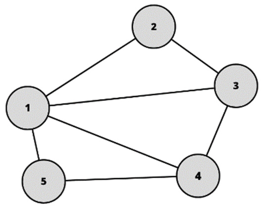
Figure 1. A simple undirected graph. Number of nodes N = 5, number of edges E = 7. Source: own elaboration.
Sustainability 15 13458 g001
Figure 2. Research workflow. Source: own elaboration.
Sustainability 15 13458 g002
Figure 3. Location of Krakow. Source: own elaboration.
Sustainability 15 13458 g003
Figure 4. The total amount of vegetation in Krakow. Source: own elaboration based on the available spatial data.
Sustainability 15 13458 g004
Figure 5. Location of selected urban parks in Krakow. Source: own elaboration based on the available data.
Sustainability 15 13458 g005
Figure 6. Example of existing routes linking urban parks.
Sustainability 15 13458 g006
Figure 7. The map showing the intersections of buffer lines. Source: own elaboration.
Sustainability 15 13458 g007
Figure 8. Force Atlas 2 graph visualizing results of DC (1), CC (2), BC (3), and EC (4) calculations for the network. Source: own elaboration.
Sustainability 15 13458 g008
Figure 9. Selected parks in Krakow with results of centralities metrics: DC (1), CC (2), BC (3), and EC (4). Source: own elaboration.
Sustainability 15 13458 g009
Figure 10. Location of disconnected parks. Source: own elaboration.
Sustainability 15 13458 g010
Figure 11. The map showing values of DBE index and the elements of the current green space management strategy (KZiRTZ).
Sustainability 15 13458 g011
Table 1. Basic parameters of selected parks.
NameNetwork IDArea (ha) 1Type
Błonia Krakowskie2241.18Public meadow
Bulwary Wisły5345.01Linear river park
Fort Batowice59.02Greenery connected with former military building
Fort Mistrzejowice305.73Greenery connected with former military building
Las Wolski48387.12Forest
Łąki Nowohuckie3863.80Public meadow
Park Aleksandry4514.79Park
Park Bednarskiego78.45Park
Park Borkowski5430.25Forest
Park Czyżyny353.11Park
Park Decjusza1210.29Park
Park Dębnicki A113.42Park
Park Dębnicki B31.32Park
Park Duchacki83.08Park
Park Jerzmanowskich15.93Park
Park Jordana1520.80Park
Park Klasztorna230.88Park
Park Kleparski143.85Park
Park Kościuszki215.26Park
Park Krakowski65.27Park
Park Krowoderski438.95Park
Park Kurdwanów185.02Park
Park Lilli Wenedy1011.01Park
Park Lotników Polskich5541.65Park
Park Łuczanowice346.69Park
Park Maćka i Doroty48.16Park
Park Miejski Bagry Wielkie3648.11Park connected with water reservoir
Park Młynówka Królewska4428.37Linear park
Park Ogród Płaszów529.07Park
Park Ratuszowy132.22Park
Park Reduta336.86Park
Park Re-Kreacja460.97Linear park
Park Rzeczny Wilga478.79River park
Park Rżąka163.60Park
Park Skalskiego196.08Park
Park Skałki Twardowskiego3953.09Park connected with water reservoir
Park Solvay4913.11Park
Park Strzelecki91.54Park
Park Szwedzki272.29Park
Park Tysiąclecia3210.15Park
Park Wadów252.37Park
Park Wincentego a’Paulo282.07Park
Park Wiśniowy Sad23.93Park
Park Witkowicki3110.41Forest
Park Wyspiańskiego262.43Park
Park Zabłocie—Stacja Wisła171.45Park
Park Zaczarowanej Dorożki202.11Park
Park Zielony Jar Wandy416.17Park
Park Żeromskiego504.12Park
Planty Bieńczyckie4017.26Park
Planty Floriana Nowackiego242.58Park
Planty Krakowskie4219.80Park
Planty Mistrzejowickie2911.15Park
Staw Płaszowski3712.63Park connected with water reservoir
Zalew Nowohucki517.68Park connected with water reservoir
1 The area was measured based on the GIS sources obtained from the Polish Geoportal website.
Table 2. The top 10 results of each centrality.
RankDCCCBCEC
Node Value Node Value Node Value Node Value
1.5324812153517.867531
2.3814848155360220.959
3.1312025135350420.831
4.4211634140224.333150.774
5.40116540.7532188.333400.701
6.27112490.7537170.560.688
7.1510840.542168.567380.636
8.22104470.536140130.621
9.29104530.3191913030.573
10.6100550.310110110.573
Table 3. Basic parameters of centrality measures and their distribution.
Centrality MeasureMeanStandard DeviationStandard ErrorGini Coefficient
Weighted Degree (DC)55.8545547.758436.380930.45313
Closeness (CC)0.2756760.251040.033850.41383
Betweenness (BC)54.52727104.392714.076310.78227
Eigenvector (EC)0.271880.283950.038290.56452
Table 4. The highest values of DBE index.
RankNodeNameDBE Value
1.53Bulwary Wisły255.622
2.35Park Czyżyny134.077
3.55Park Lotników Polskich129.414
4.40Planty Bieńczyckie113.678
5.42Planty Krakowskie95.132
6.32Park Tysiąclecia92.270
7.38Łąki Nowohuckie70.101
8.19Park Skalskiego68.794
9.37Staw Płaszowski63.539
10.13Park Ratuszowy60.985
11.7Park Bednarskiego58.425
12.44Park Młynówka Królewska56.157
Table 5. Basic parameters of DBE index.
Centrality MeasureMeanStandard DeviationStandard ErrorGini Coefficient
Compound centrality index
(DBE)
36.8845744.544996.006440.55790
Disclaimer/Publisher’s Note: The statements, opinions and data contained in all publications are solely those of the individual author(s) and contributor(s) and not of MDPI and/or the editor(s). MDPI and/or the editor(s) disclaim responsibility for any injury to people or property resulting from any ideas, methods, instructions or products referred to in the content.