Abstract
Submerged plant community construction is extensively used in the field of urban river ecological restoration, but it is sometimes difficult to establish a large area of survival or a stable community after restoration. Therefore, there is some uncertainty in determining the restoration effect. To verify the restoration effect of urban rivers replenished by reclaimed water through the application of a submerged plant community, this paper takes the typical urban rivers with reclaimed water in Beijing, the Liangshui River and the Dalong River, as the research objects and takes the Yongding River, a river replenished by natural water, as the comparison to establish a water eco-environment quality index and carry out the restoration effect evaluation of a submerged plant community based on field monitoring. In a comparison of the water eco-environment quality index of rivers and the coverage of submerged plants, the evaluation results indicate that the Yongding River and Liangshui River have the same number of submerged plant species, yet their plant coverage is different. The ecological environment quality condition of the Yongding River is superior to that of the Liangshui River and the Dalong River. The ecological environment quality of the reclaimed water river segment with an average coverage of submerged plants greater than or equal to 50% is relatively better, with relatively more sensitive species. This suggests that for rivers replenished by reclaimed water, the construction of submerged plant communities will improve the water ecological conditions on the premise of ensuring a certain degree of submerged plant species and coverage. By calculating the correlation coefficients relating to the coverage of submerged plants by 32 environmental factors including the indicators of water quality, hydrology and sediment, the paper initially screens out water depth, ammonia nitrogen, nitrite nitrogen, BOD, permanganate index, and total nitrogen and organic carbon in the sediment as the major environmental factors affecting the coverage status of submerged plants. It can provide a reference for the control of environmental factors in the construction and maintenance of submerged plants to guarantee a restoration effect in the future.
1. Introduction
Urban rivers have been closely related to the development of human society and can provide various services such as water supply, flood control, shipping, landscaping and recreation, and at the same time, they are under pressure from urban construction and development [1,2,3]. The ecosystem health of urban rivers has been more prominent in recent years and is receiving increasingly widespread attention. Due to insufficient water quantity, water contamination and channelization of rivers, the species and number of aquatic organisms in rivers have decreased, the community structure has changed, biodiversity has been lost and the water ecosystem has been severely degraded [4,5,6]. The deterioration of urban river health has threatened the immediate interests of the public, and there is an emerging demand from the public for the improvement of river ecological environment quality. As the most critical resource and environmental carrier, urban rivers are related to the development of human society, and it is an urgent issue at present to reconcile the contradiction between economic development and urban river ecosystem to achieve human-water harmony and coexistence [7].
As one of the important means to improve river health conditions and enhance the ecological service functions of rivers, water ecological restoration has received increasingly extensive attention both domestically and internationally [8]. Studies and practices on ecological restoration of rivers are more frequent in the United States, Japan and a number of countries in Europe [9,10,11], and the related studies mainly concentrate on the restoration strategies for river ecosystems and the restoration of water quality, water quantity, riparian zones and other elements in river ecosystems [12]. Recently, many cities have implemented the use of reclaimed water to replenish rivers, which has played a vital part in alleviating the contradiction between urban water supply and demand as well as improving the quality of the water environment. However, eutrophication is more likely to occur in landscape water bodies replenished by reclaimed water than in natural rivers [13]. To further purify the water quality of rivers, improve the habitat conditions of rivers and enhance the landscape effect, submerged plant community construction is gradually applied to urban river water ecological restoration [14]. Submerged plants refer to large aquatic plants whose plant bodies are all located below the water layer for survival in fixation, belonging to herbaceous plants, and most of the leaves of these plants are ribbonlike or filamentous; examples include vallisneria, hornwort, Myriophyllum verticillatum and Hydrilla verticillata. Submerged plants are not only significant primary producers of the water ecosystem, but also important regulators of the quality of the water environment; they occupy critical interfaces in the water ecosystem and have an important effect on the material and energy cycles in the water ecosystem. When submerged plant communities are constructed, the submerged plants can not only play a purifying role in water quality, but also provide appropriate habitats for fish, benthic animals and others and embellish the surrounding environment [15,16,17]. There are many examples of restoration for eutrophic water bodies with the application of submerged plants [18,19], and the application of submerged plants in urban river restoration has been reported to achieve more desirable outcomes, forming a “submerged forest” landscape in the river through reasonable planting of submerged plants and better artificial maintenance in later stages.
Despite the fact that submerged plant construction improves the ecological condition of the river in both laboratory experiments and examples of urban rivers with strong human intervention, there remains a certain degree of uncertainty about the effect of restoration with submerged plant communities in field practice. The growth process of submerged plants is affected by a combination of various factors [20,21], and when the dominant factors affecting submerged plants are not known and human intervention is lacking, it is sometimes difficult to establish a large area of survival or a stable population or community after restoration [22]. For example, according to experimental data, organic-rich sediment can hinder the absorption of nutrients by submerged plants and may also exacerbate the effects of other stress factors [23]. Meanwhile, the restoration effect often cannot be demonstrated for at least one year after the construction of submerged plants. In response to the drawbacks of water ecological restoration, follow-up monitoring and effect evaluation after river water ecological restoration have been carried out abroad [24,25,26,27,28]. For example, an effectiveness evaluation of Project River Recovery (PRR) was conducted in New Zealand to restore the habitat of rivers and wetlands in the Waitaki Basin. Monitoring and analysis of habitat improvements over the past decade of the PRR program yielded strengths and areas in need of improvement, making it an effective way to ensure restoration success. Therefore, it is considered that monitoring and evaluation after restoration is an effective method to ensure the successful completion of restoration [29,30]. A series of evaluations have also been conducted in China for the evaluation of river water ecological restoration effects [31,32,33].
As an international metropolis, Beijing is also a water-scarce city where human–water conflicts have always been prominent and the water ecological condition of rivers is not positive. In recent years, Beijing has carried out a series of river water ecological restoration projects, and the water quality, hydrology and riparian landscape of some rivers have been significantly improved. The construction of submerged plant communities as an important means of water ecological restoration has been gradually applied to improve the ecological conditions of urban rivers. To verify the ecological restoration effect and properly adjust and optimize the restoration measures, it is necessary to carry out water ecological monitoring and evaluation of the restoration effect for urban rivers that are restored by submerged plant communities.
Using site survey and field monitoring methods, in this study, we took the urban rivers replenished by reclaimed water in Beijing—Liangshui River and Dalong River as the research objects; carried out the monitoring of water ecological environment quality of the rivers; selected the appropriate water quality, aquatic biological indicators and habitat indicators; constructed the water eco-environment quality index; and took the Yongding River, which is replenished by natural water, as a comparison to evaluate the restoration effect of submerged plant communities. Meanwhile, in this study, we tentatively determined the major environmental factors affecting the submerged plant communities by calculating the correlation coefficients, providing a certain basis for further guiding the construction and maintenance of submerged plant communities.
2. Materials and Methods
2.1. Study Area and Data Sources
The main rivers replenished with reclaimed water in the urban area of Beijing were selected for the site survey in this study. According to the distribution, habitat characteristics, substrate features and sampling conditions of submerged plants in the rivers, we selected two rivers replenished by reclaimed water, namely the Liangshui River and the Dalong River, and selected the Shanxia segment of the Yongding River as a comparison for the restoration effect evaluation of submerged plant communities. The Liangshui River and Dalong River are located in the North Canal Basin (within Beijing), with a watershed area of 4348 km2, and many rivers in the basin are important components of the urban water system in Beijing, serving the functions of flood control and drainage, ecological landscaping and recreation of the urban water system. The climate of the North Canal Basin is a temperate continental monsoon climate, characterized by cold and dry winters, hot and rainy summers, and dry and windy springs, with large temperature variations in winter and summer. The wind in winter is mostly from the northwest, with an average wind speed of 3.0–3.5 m/s and a maximum wind speed of 22.0 m/s. The average annual evaporation on land is 400–500 mm, and the average annual evaporation on water is 1120 mm. Both the Liangshui River and the Dalong River are typical urban rivers sourced from the Xiaohongmen Reclaimed Water Plant. A series of near-naturalized water ecological restorations have been carried out in the rivers in recent years. According to the site survey, a large variety of submerged plants are distributed in the rivers, which is suitable for the study of the restoration effect of submerged plant communities.
The data of this study were mainly derived from the field monitoring of water quality and sediment, field sampling of aquatic organisms and field surveying of habitat conditions. According to the “Technical Guide for Monitoring and Evaluation of River Water Ecological Environment Quality” issued by the Ministry of Ecology and Environment and literature research, we determined the water and sediment quality parameters. All the indicators were monitored once. The water quality monitoring items included pH, dissolved oxygen (DO), permanganate index (CODMn), five-day biochemical oxygen demand (BOD5), ammonia nitrogen (NH3-N), total phosphorus (TP), total nitrogen (TN), arsenic (As), mercury (Hg), cadmium (Cd), chromium (hexavalent) (Cr), lead (Pb), cyanide, volatile phenols, petroleum, electrical conductivity, turbidity, nitrate nitrogen (NO3-N) and nitrite nitrogen (NO2-N). Water quality indicators were monitored in accordance with the “Technical Specification for Surface Water and Sewage Monitoring” (HJ/T91-2002). Sediment monitoring items mainly included total nitrogen (TN), total phosphorus (TP), mercury (Hg), arsenic (As), lead (Pb), cadmium (Cd) and organic carbon (OC). The monitoring methods were performed with reference to the relevant monitoring norms and standards for soil. The apparatus used for the collection of water was a 1 L plexiglass water sampler. A Peterson mud sampler with a sampling area of 1/16 m2 was used for sediment collection. The aquatic organisms were mainly investigated in terms of the species and quantity of macrobenthic invertebrates and submerged plants. The samples of benthic animals were collected with a D-type hand-operated net. The submerged plant community was surveyed using the quadrat method. Each sample plot was set up with 3–5 quadrats with an area of 1 m2. The importance value of submerged plants was expressed as the mean value of relative height, relative coverage and relative frequency. The coverage of submerged plants was characterized by the ratio of the area of submerged plants in the waters within 6 m depth to the water area.
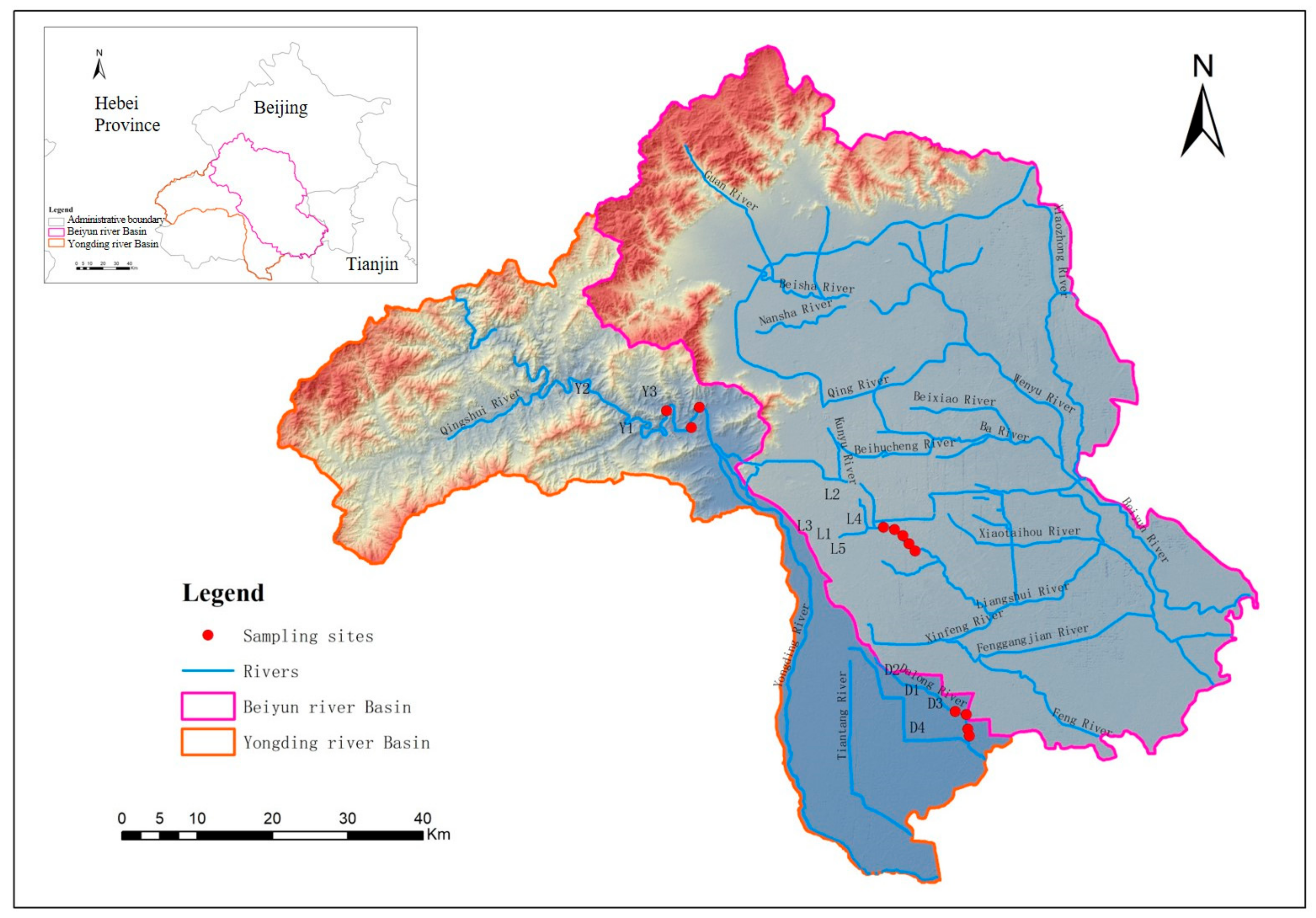
In October 2020, this study set a total of 12 sampling sites for field monitoring of the river water ecological environment for the Liangshui River (5 sampling sites), the Dalong River (4 sampling sites) and the comparison river Yongding River (Shanxia segment, 3 sampling sites), and the distribution of sampling sites is shown in Figure 1.

Figure 1.
Distribution of sampling sites for field monitoring of typical rivers.
2.2. Comprehensive Evaluation of River Water Ecological Environment Quality
This study included a comprehensive assessment of the water ecological environment quality of the river in which the submerged plant community was located, referring to the comprehensive index method in the “Technical Guide for Monitoring and Evaluation of River Water Ecological Environment Quality” issued by the Ministry of Ecology and Environment, combined with the condition of the study area, and the restoration effect of the submerged plant community was analyzed by comparison.
By weighting and summing the water chemistry index, aquatic organism index and habitat index, the water eco-environment quality index of the river (WEQIriver) was constructed. The water quality evaluation was carried out with reference to GB 3838 [34] for single-factor evaluation (water temperature and pH were not used as evaluation indicators). The classification of the water quality category level referred to the water quality evaluation method of the rivers in the “Surface Water Environmental Quality Evaluation Measures” (General Office of the Ministry of Environmental Protection of the People’s Republic of China [2011] No. 22) and finally assigned points according to the water quality category level. River habitat evaluation was performed in accordance with the wadeable river habitat survey data sheet to score each of the 10 parameters. Each parameter was scored in the range of 0 to 20 and divided into five evaluation levels. The total score of each monitoring section was calculated by adding up the scores of the 10 parameters.
For the selection of aquatic organism indices, we referred to the recommended indices in the Guide and took the macrobenthos, which had strong regional characteristics and generally had less ability to avoid external disturbance, as the indicator species, combined with the availability of actual measurement data, and selected the biological monitoring working party (BMWP) scoring system and the Shannon–Wiener diversity index from the perspectives of macrobenthos tolerance to pollutants and species diversity to evaluate the water eco-environmental quality, and the worst evaluation results were adopted to represent the evaluation results for aquatic organisms.
(1) BMWP scoring system
The BMWP scoring system used the macrobenthos as indicator organisms and was based on the evaluation principle that different macrobenthic species have different sensitivity/tolerance to organic pollution (e.g., eutrophication), and scores were assigned according to the tolerance level of each taxon. The water quality condition was evaluated according to the range of the score distribution. Larger BMWP scores indicated better water quality [14].
The BMWP scoring system was based on families, and the sum of the scoring values of each family in each sample was the BMWP score; families with only one or two individuals in the sample were not included in the scoring.
(2) Shannon–Wiener diversity index
The Shannon–Wiener diversity index reflected the complexity of the biological community structure. Its evaluation principle was established based on the following principles: normally, the greater the diversity index, the more complicated the community structure, the more stable the community, the better the eco-environmental condition; when the water body is polluted, certain species will die out, the diversity index decreases, and the community structure tends to be simple, indicating a decline in water quality.
The WEQIriver is calculated according to the following formula:
where WEQIriver—water eco-environment quality index of the river;
- Xi—the evaluation index score;
- Wi—the weight of the evaluation index.
According to the score of WEQIriver, the water eco-environmental quality condition was divided into five grades, which are excellent, good, average, poor and very poor, and the specific index score and quality condition grading are detailed in Table 1.

Table 1.
Water eco-environmental quality condition grading standards.
2.3. Statistical Analysis
Correlation analysis was applied to analyze the relationship between environmental factors and submerged plant coverage to identify the major environmental factors affecting the submerged plant coverage condition. The Pearson correlation coefficient was computed. IBM SPSS Statistics 22 software was used for the execution of correlation analysis.
3. Results and Discussion
3.1. Analysis of Submerged Plant Community Characteristics
In this study, a total of nine species of submerged plants, belonging to six genera, six families, five orders and three classes, were collected from the urban rivers replenished by reclaimed water, namely the Liangshui River and the Dalong River, and the comparison river, the Yongding River (Table 2). From the viewpoint of submerged plant species, the Liangshui River and Yongding River had the same richness, and the richness of the Dalong River was relatively lower. The average river submerged plant coverage varied significantly, with the Yongding River having a relatively high average submerged plant coverage of 78%, the Liangshui River being the second and the Dalong River having a relatively low submerged plant coverage.
Table 2.
Distribution and phenological observation of submerged plants in rivers.
The density and biomass of submerged plants differed significantly. Characteristic indicators of river submerged plant communities were showed in Table 3. In the Yongding River, Chara globularis was relatively denser, while Potamogeton pectinatus had a higher biomass; in the Liangshui River, Myriophyllum verticillatum was denser, while Potamogeton pectinatus had a higher biomass; in the Dalong River, Hydrilla verticillata was denser, while the biomass of Hornwort was larger. According to the importance values of submerged plants in the river, Myriophyllum verticillatum was predominant and Cladophora oligoclona was least predominant in the Liangshui River, Potamogeton lucens was predominant and Cladophora oligoclona was least predominant in the Dalong River, and Potamogeton pectinatus was predominant and Najas marina was least predominant in the Yongding River.
Table 3.
Characteristic indicators of river submerged plant communities.
It can be observed from the above-mentioned results that the abundance of submerged plant communities in the rivers replenished by reclaimed water was basically the same as that in the river replenished by natural water, and the species were basically common universal species; however, the coverage of submerged plants in the rivers replenished by reclaimed water was relatively low, and a small number of pollution-tolerant species such as Cladophora oligoclona existed. Meanwhile, the self-regulation capacity of urban rivers was limited after restoration due to the severe damage caused by human activities [31]. It could also be observed that for urban rivers, the stable presence of a variety of submerged plants could be achieved through artificial planting, yet a certain level of coverage was unable to be maintained, making it difficult for sensitive species to survive in urban rivers.
3.2. Comprehensive Evaluation of River Water Eco-Environmental Quality
The water quality monitoring results of each river were compared with “Environmental Quality Standards for Surface Water” (GB3838-2002), which is the national standard suitable for surface waters such as rivers, lakes, canals, channels and reservoirs within the territory of the People’s Republic of China. All monitoring indices of the monitoring sections did not exceed the V standard. Almost all of the test index values did not exceed the III standard, except for petroleum. The range of petroleum indices for various points was 0.09–0.17 mg/L. The III standard for petroleum was ≤0.05 mg/L, and the IV standard for petroleum was ≤0.5 mg/L. The petroleum monitoring results all exceeded the III standard but were less than the IV standard. Therefore, the petroleum indices of all points conformed to the IV water body standard, and all points were classified as IV water bodies according to the single-factor evaluation method, with a water quality score of 3. The data of main water and sediment quality parameters had been shown in Table 4.
Table 4.
The data of main water and sediment quality parameters.
For aquatic organisms, the Shannon–Wiener diversity index and the BMWP index for benthic animals were calculated in this study. The evaluation result of the BMWP index was selected as the final aquatic organism evaluation result due to its relatively poor evaluation result according to the score assigned to each index.
Table 5 showed the comprehensive evaluation results for eco-environmental quality of typical rivers. By combining water quality, aquatic organisms and habitat scores to calculate the WEQIriver, we carried out a comprehensive evaluation of river ecological conditions and obtained the comprehensive index and grades of each river segment of the Yongding River, Liangshui River and Dalong River. The evaluation results revealed that No. 1 and No. 2 of the Yongding River had a good grade, and No. 3 of the Yongding River had an average grade; the grade of each segment of the Liangshui River was average; No. 1 and No. 2 of the Dalong River had an average grade, and No. 3 and No. 4 of the Dalong River had a poor grade. As a whole, the average comprehensive index of the Yongding River is 3.3, representing a good grade; the average comprehensive index of the Liangshui River is 2.7, representing an average grade; and the average comprehensive index of the Dalong River is 2.2, representing an average grade.
Table 5.
Comprehensive evaluation results for eco-environmental quality of typical rivers.
3.3. Comparative Evaluation of the Restoration Effect of Submerged Plant Communities
This paper compares the health condition and distribution of the submerged plants in the rivers replenished by reclaimed water (Liangshui River and Dalong River) and the river replenished by natural water in the Shanxia segment (Yongding River). Figure 2 shows a comparison of the eco-environmental quality of different types of rivers. The histogram legend for submerged plant coverage presents data values referenced to the left Y-axis. The histogram legend for WEQIriver presents data values referenced to the right Y-axis. The ecological environment quality of the river replenished by natural water was superior to that of the rivers replenished by reclaimed water. In combination with the coverage of submerged plants, the average coverage of submerged plants in the river replenished by natural water was 78%, while that in the rivers replenished by reclaimed water was 43%, indicating that more submerged plant coverage would have a positive ecological effect on the improvement of water ecological health. Liu et al. [35] considered that in a certain range, the higher the biomass or coverage of submerged plants, the better the purification effect of nitrogen and phosphorus nutrients in eutrophic water. In this study, the ecological environment quality of the river segments with higher submerged plant coverage was better, which was consistent with the results of previous studies. Moreover, we found that the rivers replenished by reclaimed water were less likely to maintain high submerged plant coverage compared to the river replenished by natural water, indicating that more manual control is required for submerged plant maintenance.
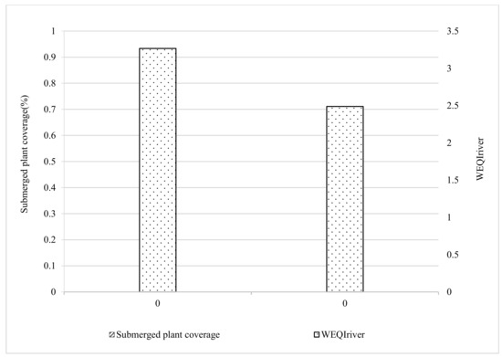
Figure 2.
Comparison of eco-environmental quality of different types of rivers.
This paper reflects the restoration effect of submerged plant communities by comparing the ecological conditions of rivers replenished by reclaimed water under different average submerged plant coverage (Figure 3). Specifically, we calculated the WEQIriver and BMWP of the river segments replenished by reclaimed water with the average submerged plant coverage of ≥50% and <50%, and the results showed that the WEQIriver of the river segments with different average submerged plant coverage levels were in the range of 2–3, which was in the general grade. However, the WEQIriver values of river segments replenished by reclaimed water with average submerged plant coverage ≥50% were still greater than those with average submerged plant coverage <50%, and the BMWP index of the benthic animals in river segments with higher average coverage was much greater than that in those with lower coverage, indicating that water bodies with higher submerged plant coverage have relatively more sensitive species and relatively better ecological environment quality. This indicated that for rivers replenished by reclaimed water, submerged plants would have some positive ecological effects on the improvement of water ecological conditions. Submerged plants can not only purify water quality, but also provide food, space and other necessary conditions for the growth of other organisms [36]. Therefore, maintaining a certain coverage of submerged plants played an important role in increasing the sensitive macrobenthic species and thus improving the ecological quality of the water.
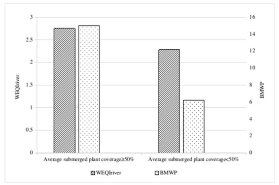
Figure 3.
Comparison of ecological conditions under different submerged plant coverage levels in rivers replenished by reclaimed water (Liangshui River and Dalong River).
3.4. Analysis of Influencing Factors of Submerged Plant Growth
The construction of submerged plant communities by means of artificial or natural propagation plays an important role in the improvement of the quality of the river water ecological environment [36,37]. The results of this study showed that there were some differences in the restoration effect of different river segments. The growth process of submerged plants is jointly affected by several environmental factors [38]. It is necessary to identify the major environmental factors affecting the growth of submerged plants under field conditions to ensure the effective restoration of submerged plants. For this paper, we combined field monitoring data with the calculation of correlation coefficients relating to submerged plant coverage for 32 environmental factors such as water quality, hydrology and sediment and initially analyzed the degree of the effect of each environmental factor on the submerged plant community and screened the major environmental factors affecting the submerged plant coverage condition.
The calculation of the correlation coefficients between environmental factors and submerged plant coverage (Table 6) indicated that hydrological, water quality and sediment factors had various degrees of effect on submerged plant coverage, among which the factors with greater effect (r > 0.5) were water depth (r = −0.534), ammonia nitrogen (r = −0.767), nitrite nitrogen (r = −0.751), BOD (r = 0.855), permanganate index (r = 0.869) in the water, and total nitrogen (r = 0.786) and organic carbon (r = 0.548) in the sediment.
Table 6.
Correlation coefficients of environmental factors and submerged plant coverage.
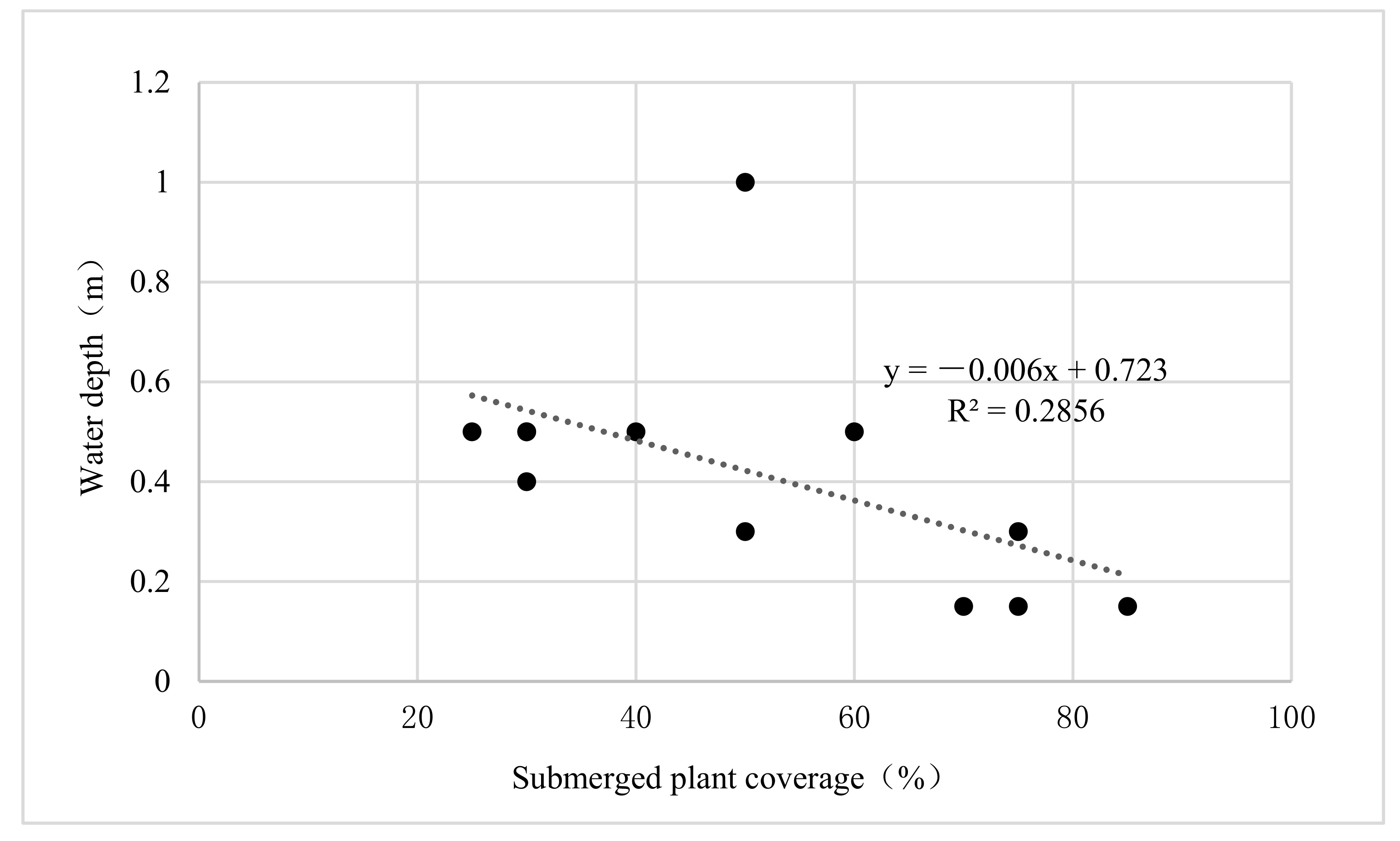
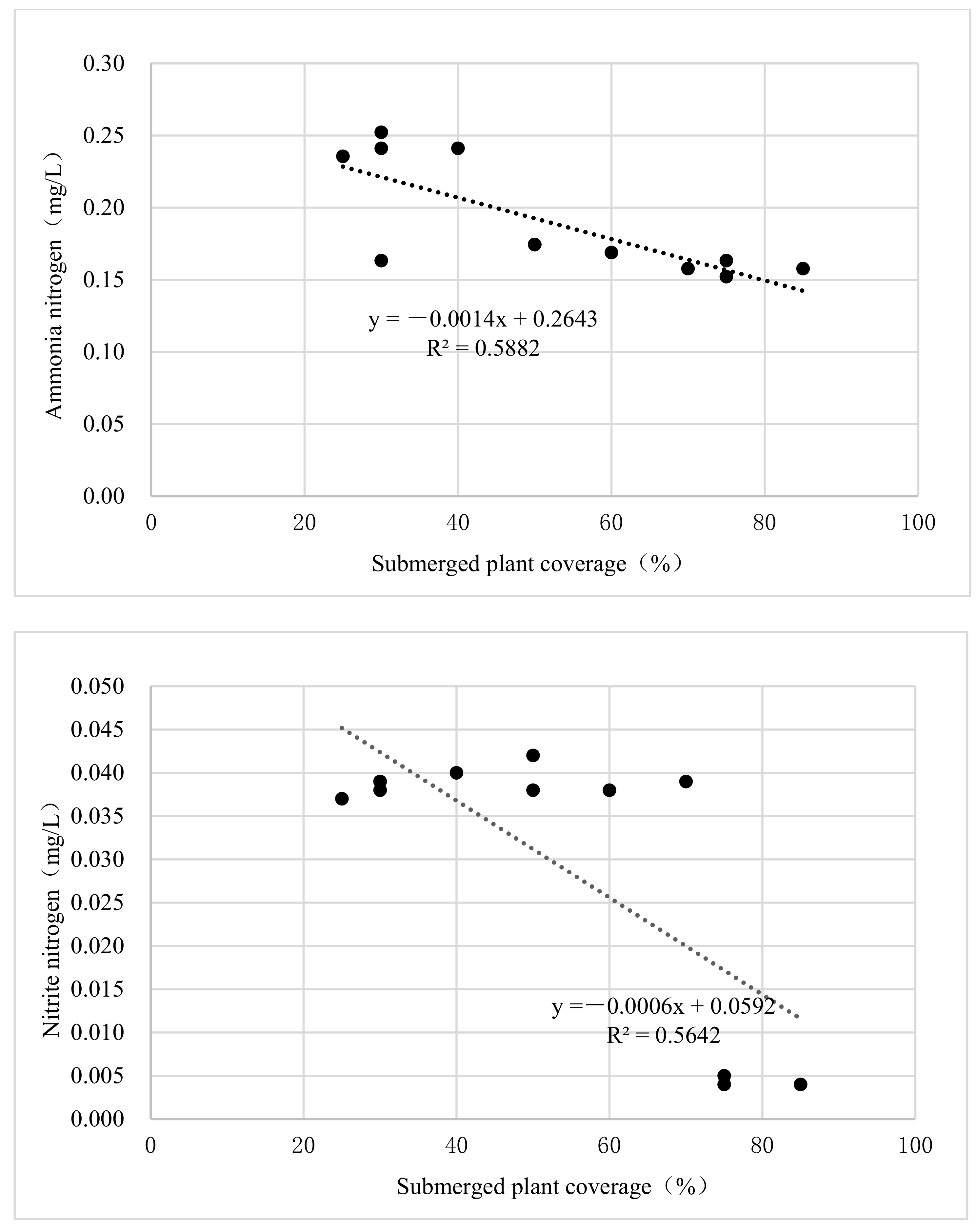
Based on the trends of the correlation between environmental factors with greater effects of hydrology, nutrients and submerged plant coverage (Figure 4), further analysis was carried out for this paper. With the increase in water depth and the concentration of ammonia nitrogen and nitrite nitrogen, the growth of submerged plants was suppressed to a certain extent, indicating that a certain range of water depth and nutrient concentration existed for the suitable growth of submerged plants.
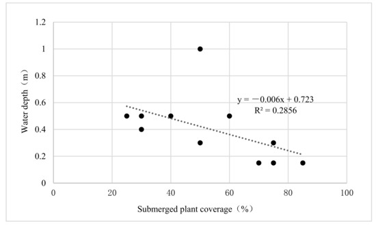
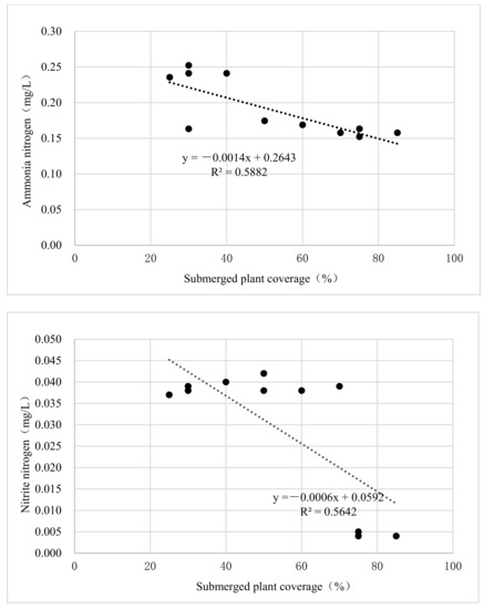
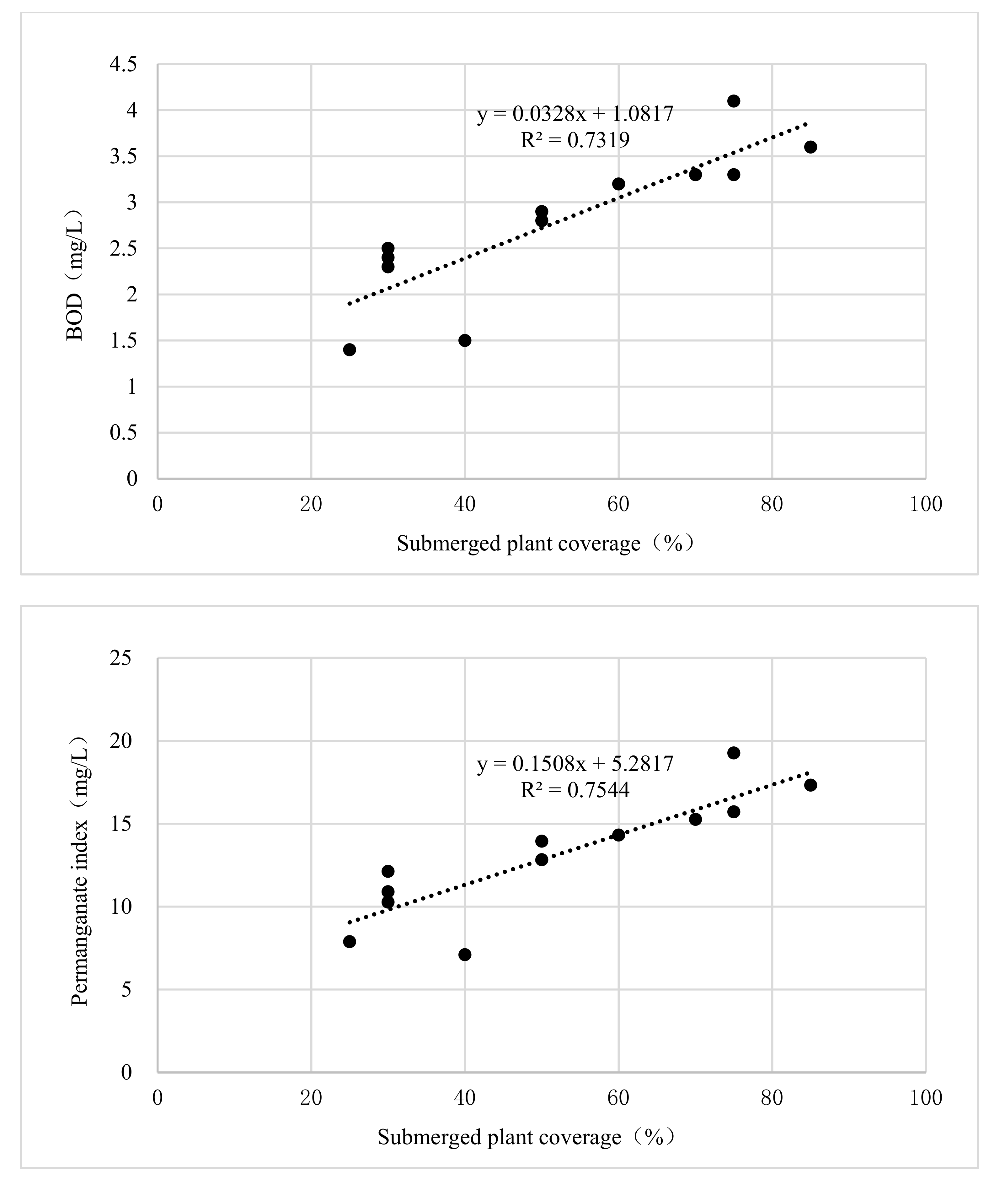
Figure 4.
Correlation analysis between major water quality and hydrological factors and submerged plant coverage.
According to the trend of the correlation between the environmental factors of organic pollutants with greater effect and the coverage of submerged plants (Figure 5), the coverage showed an increasing trend with the increase in BOD and permanganate concentration, indicating that the increase in organic pollutants to a certain extent can promote the growth of submerged plants, reflecting that the indication effect of submerged plants on the increase in organic pollutants to a certain extent was not significant.

Figure 5.
Correlation analysis between major organic pollutant factors and submerged plant coverage.
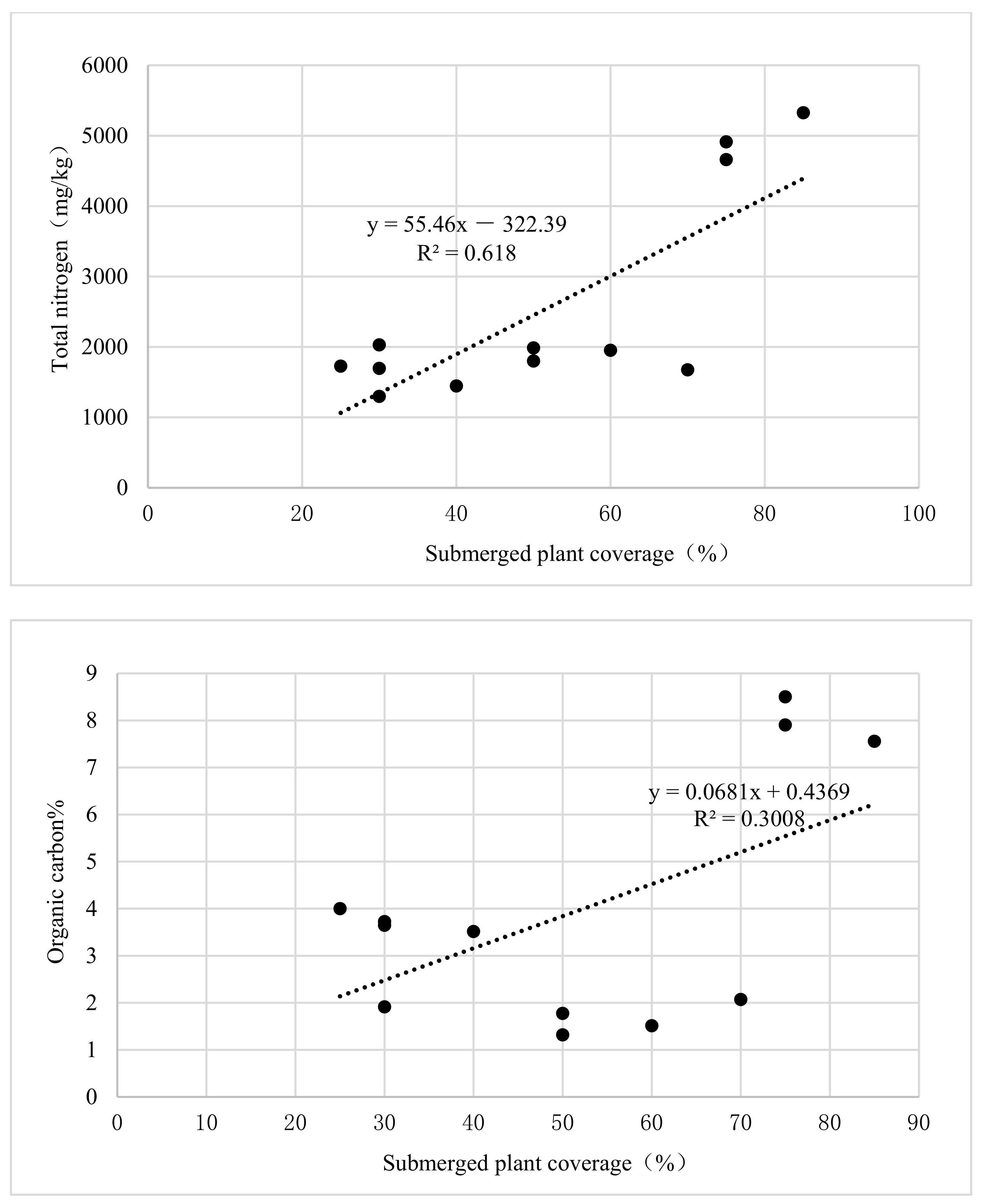
According to the trend of the correlation between sediment environmental factors with greater influence and submerged plant coverage (Figure 6), the increase in total nitrogen and organic carbon content in the sediment had a positive effect on the growth of submerged plants. The data points formed distinct clusters or groups of samples, especially for organic carbon content in the sediment, because the environment data from the same river had certain similarities, while data from different rivers were different. For example, the value of organic carbon in the Dalong River ranged from 3 to 4, the value of organic carbon in the Liangshui River ranged from 1 to 2 and the value of organic carbon in the Yongding River ranged from 7 to 9. Different value ranges formed the various data groups presented in the figure.
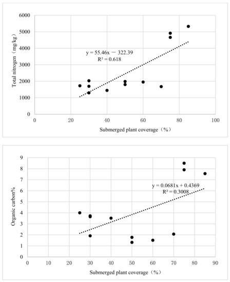
Figure 6.
Correlation analysis between major sediment environmental factors and submerged plant coverage.
The results indicated that the nutrients and organic matter in water and sediment were the main environmental factors affecting the growth of submerged plants, which was basically consistent with the research results in the literature [15]. Furthermore, we found that each factor had a certain range of values suitable for the optimal growth of submerged plants. It can be seen from the above findings that data experiments were necessary to determine the regulatory range of environmental factors.
4. Conclusions
Based on water ecological environment quality monitoring, in this study, we analyzed the community characteristics of submerged plants and applied a comprehensive method for evaluating the water eco-environmental quality of rivers to evaluate the restoration effect of submerged plant communities in the Liangshui River and the Dalong River, replenished by reclaimed water, in Beijing. The findings indicated that the richness of submerged plant communities in rivers replenished by reclaimed water was basically the same as that in rivers replenished by natural water, yet the average coverage of submerged plants was relatively low. For urban rivers, the stable presence of various submerged plants could be achieved through artificial planting. Maintaining a certain coverage required more manual control after restoration. Submerged plants would have some positive ecological effects on the improvement of water ecological conditions. The ecological environment quality of the river segments with higher submerged plant coverage was better. Due to the diversity of environmental factors, there were some differences in the restoration effect of various river segments. The results of correlation coefficients relating to submerged plant coverage for 32 environmental factors showed that the nutrients and organic matter in water and sediment were the main environmental factors affecting the growth of submerged plants. Each factor had a certain range of values suitable for the optimal growth of submerged plants. Limited by the amount of data, this study only preliminarily analyzed the relationship between environmental factors and submerged plant growth. Moreover, field experimental studies would be highly desirable in future research to determine the key factors affecting the growth of submerged plants and the regulatory range of environmental factors suitable for the growth of submerged plants, so as to achieve the ideal restoration effect by artificially regulating submerged plant communities.
Author Contributions
Methodology, X.W.; Formal analysis, Y.W.; Investigation, J.D.; Resources, C.S.; Writing—original draft, F.X.; Writing—review & editing, F.X.; Visualization, Y.L. All authors have read and agreed to the published version of the manuscript.
Funding
Fund of the Beijing Municipal Research Institute of Eco-Environmental Protection (Y2023-002).
Institutional Review Board Statement
Not applicable.
Informed Consent Statement
Not applicable.
Data Availability Statement
The data used in the study had been obtain from field monitoring. The study did not report any data.
Conflicts of Interest
The authors declare no conflict of interest.
References
- Karr, J.R.; Chu, E.W. Sustaining living rivers. Hydrobiologia 2000, 422, 1–14. [Google Scholar] [CrossRef]
- Yang, L.R.; Chen, L.D.; Sun, R.H. River ecosystems and their self-purification capability: Research status and challenges. Acta Ecol. Sin. 2009, 29, 5066–5075. [Google Scholar]
- Angela, J.D.; Angela, M.G.; Patrick, D.A. Habitat survey and classification of urban rivers. River Res. Appl. 2004, 20, 687–704. [Google Scholar]
- Ma, K.M.; Kong, H.M.; Guan, W.B.; Fu, B.J. Ecosystem health assessment: Methods and directions. Acta Ecol. Sin. 2001, 21, 2106–2114. [Google Scholar]
- Chovanec, A.; Schiemer, F.; Waidbacher, H.; Spolwind, R. Rehabilitation of a heavily modified river section of the Danube in Vienna (Austria): Biological assessment of landscape linkages on different scales. Int. Rev. Hydrobiol. 2002, 87, 183–195. [Google Scholar] [CrossRef]
- Poudevigne, I.; Alard, D.; Leuven, R.S.E.W.; Nienhuis, P.H. A systems approach to river restoration: A case study in the lower seine valley, France. River Res. Appl. 2002, 18, 239–247. [Google Scholar] [CrossRef]
- Zhao, Y.W.; Yang, Z.F. Brief discussion on ecosystem restoration of urban river. Bull. Soil Water Conserv. 2006, 26, 89–93. [Google Scholar]
- Chen, X.R. Progress of river restoration research at home and abroad. J. Hydroecol. 2011, 32, 122–128. [Google Scholar]
- Gore, J.A.; Shields, F.D. Can large rivers be restored? BioScience 1995, 45, 142–152. [Google Scholar] [CrossRef]
- Nienhuis, P.H.; Leuven, R.S.E.W. River restoration and flood protection: Controversy or synergism? Hydrobiologia 2001, 444, 85–99. [Google Scholar] [CrossRef]
- Wang, W.; Li, C.Q. River corridors and ecological restoration. Water Resour. Hydropower Eng. 2003, 34, 56–59. [Google Scholar]
- Yang, J.P.; Wang, T.L.; Fang, H.M.; Su, Z.L. Research progress of river ecological restoration. Res. Soil Water Conserv. 2012, 19, 209–304. [Google Scholar]
- Liu, K. Ecological and Environmental Effects of Reclaimed Water Replenishment from Typical Rivers and Lakes in Beijing; Capital Normal University: Beijing, China, 2012. [Google Scholar]
- Xie, Y. Study on Field Experiment and Mechanism of Eutrophic Landscape Water Restoration Using Plants; Xi’an University of Architecture and Technology: Xi’an, China, 2011. [Google Scholar]
- Wang, H.; Pang, Y.; Liu, S.B.; Ma, X. Research progress on influencing of environmental factors on the growth of submersed macrophytes. Acta Ecol. Sin. 2008, 28, 3958–3968. [Google Scholar]
- Shen, Y.S.; Zhang, Y.X.; Zhang, C.Y.; Liu, Z.N.; Zhang, M. Experimental study of the effects of 5 species of plant-mattress system on eutrophic water remediation. Environ. Prot. Sci. 2017, 43, 71–76. [Google Scholar]
- Guo, Y.Q.; Xue, J.H.; Wu, Y.B.; Zhou, Z.D.; Hua, J.F. Research progress on purification effects and restoration technologies of submerged macrophytes on eutrophic water. J. Plant Resour. Environ. 2020, 29, 58–68. [Google Scholar]
- Gao, J.Q.; Xiong, Z.T.; Zhang, W.H.; Deng, X.W.; Shang, L.Y.; Fu, C.Y. Removal efficiency of phosphorus in hypertrophic lake Donghu water by common submerged macrophytes. Resour. Environ. Yangtze Basin 2007, 16, 796–800. [Google Scholar]
- Huang, X.L.; Guo, Y.M.; Wan, B.; Hu, H.J.; Tong, L.; Li, X.P. Effect of submerged macrophytes restoration on the ecological environment of urban eutrophic lake. Environ. Eng. 2018, 36, 17–21. [Google Scholar]
- Han, B.; Zhang, S.H.; Wang, P.F.; Wang, C. Effects of water flow on submerged macrophyte-biofilm systems in constructed wetlands. Sci. Rep. 2018, 8, 2650. [Google Scholar] [CrossRef]
- Li, H.M.; Li, Q.; Luo, X.; Fu, J.; Zhang, J. Responses of the submerged macrophyte Vallisneria natans to a water depth gradient. Sci. Total Environ. 2020, 701, 134944. [Google Scholar] [CrossRef]
- Zuo, J.C.; He, F.; Chen, S.P.; Wu, J.; Wu, Z.B. Stresses of eutrophic lake sediment on submerged macrophytes I. Effects of acetic acid on germination and bud growth of Elodea nuttallii and Potamogeton crispus. J. Wuhan Bot. Res. 2006, 24, 424–428. [Google Scholar]
- Ni, L.Y. Stress of fertile sediment on the growth of submersed macrophytes in Eutrophic waters. Acta Hydrobiol. Sin. 2001, 25, 399–405. [Google Scholar]
- Nelson, E.A.; Dulohery, N.C.; Kolka, R.K.; McKee, W.H. Operational restoration of the Pen Branch bottomland hardwood and swamp wetlands—The research setting. Ecol. Eng. 2000, 15 (Suppl. 1), S23–S33. [Google Scholar] [CrossRef]
- Simons, J.H.E.J.; Bakker, C.; Schropp, M.H.I.; Jans, L.H.; Kok, F.R.; Grift, R.E. Man-made secondary channels along the river Rhine (The Netherlands); results of post-project monitoring. Regul. Rivers Res. Manag. 2001, 17, 473–491. [Google Scholar] [CrossRef]
- Ormerod, S.J. A golden age of river restoration science? Aquat. Conserv. Mar. Freshwater Ecosyst. 2004, 14, 543–549. [Google Scholar] [CrossRef]
- Mccormick, A.; Fisher, K.; Brierley, G. Quantitative assessment of the relationships among ecological, morphological and aesthetic values in a river rehabilitation initiative. J. Environ. Manag. 2015, 153, 60–67. [Google Scholar] [CrossRef] [PubMed]
- Saha, D.; Das, D.; Dasgupta, R.; Patel, P.P. Application of ecological and aesthetic parameters of riparian quality assessment of a small tropical river in eastern India. Ecol. Indic. 2020, 117, 106627. [Google Scholar] [CrossRef]
- Schiemer, F.; Baumgartner, C.; Tockner, K. Restoration of floodplain rivers: The ‘Danube restoration project’. Regul. Rivers Res. Manag. 1999, 15, 231–244. [Google Scholar] [CrossRef]
- Caruso, B.S. Effectiveness of braided, gravel-bed river restoration in the upper Waitaki Basin, New Zealand. River Res. Appl. 2006, 22, 905–922. [Google Scholar] [CrossRef]
- Liu, P.B.; Shen, L.X.; Liu, J.G.; Gao, X.W.; Wang, G.Q. Ecological restoration effect evaluation of Yongding River (Beijing Section) based on ecological service value. Water Resour. Hydropower Eng. 2016, 47, 9–13. [Google Scholar]
- Liu, X.Y. Ecological Landscape Management Model and Effect Evaluation of Mencheng Lake in Yongding River; Tsinghua University: Beijing, China, 2017. [Google Scholar]
- Yang, W.; Pei, J.; Li, X.X.; Sun, T.; Wang, W.Y. Effect evaluation and management strategies for freshwater restoration projects in Yellow River Delta wetlands. J. Beijing Norm. Univ. 2018, 54, 98–103. [Google Scholar]
- GB 3838-2002; Environmental Quality Standards for Surface Water. Standardization Administration of China: Beijing, China, 2020.
- Liu, L.; Guan, Y.T.; Qin, T.J.; Wang, Y.Y.; Li, H.L.; Zhi, Y.B. Effects of water regime on the growth of the submerged macrophyte Ceratophyllum demersum at different densities. J. Freshwater Ecol. 2018, 33, 45–56. [Google Scholar] [CrossRef]
- Shen, Y.L.; Wang, M.J.; Li, Y.; Zhang, W.J.; Fei, Z.M.; Luo, L.; Huang, Y. Research on purification efficiency of polluted water remediation by submerged macrophytes. J. Univ. Sci. Technol. Suzhou 2005, 18, 1–4. [Google Scholar]
- Zhong, Q.R.; Yu, F.Y. Study on water quality improvement by ecological restoration of Tianmei River in Guangzhou. Guangdong Water Res. Hydropower 2012, 7, 31–34. [Google Scholar]
- Irfanullah, H.M.; Moss, B. Factors influencing the return of submerged plants to a clear-water, shallow temperate lake. Aquat. Bot. 2004, 80, 177–191. [Google Scholar] [CrossRef]


Disclaimer/Publisher’s Note: The statements, opinions and data contained in all publications are solely those of the individual author(s) and contributor(s) and not of MDPI and/or the editor(s). MDPI and/or the editor(s) disclaim responsibility for any injury to people or property resulting from any ideas, methods, instructions or products referred to in the content. |
© 2023 by the authors. Licensee MDPI, Basel, Switzerland. This article is an open access article distributed under the terms and conditions of the Creative Commons Attribution (CC BY) license (https://creativecommons.org/licenses/by/4.0/).