
Radar Interferometry for Urban Infrastructure Stability Monitoring: From Techniques to Applications


Abstract
:1. Introduction
2. Radar Interferometry
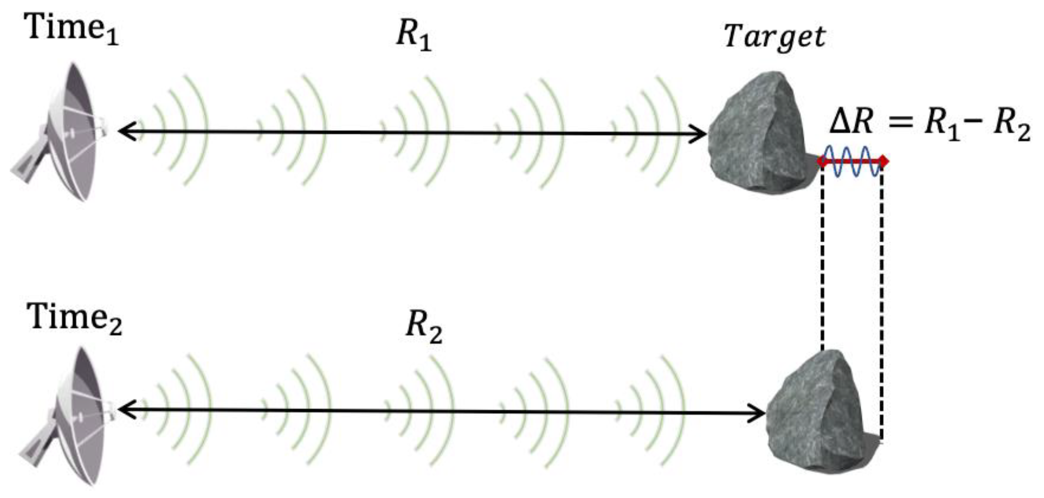
2.1. Principle
2.2. Development of Radar Interferometry Techniques
2.2.1. Spaceborne InSAR
2.2.2. GBRI Technique
2.3. Characteristics
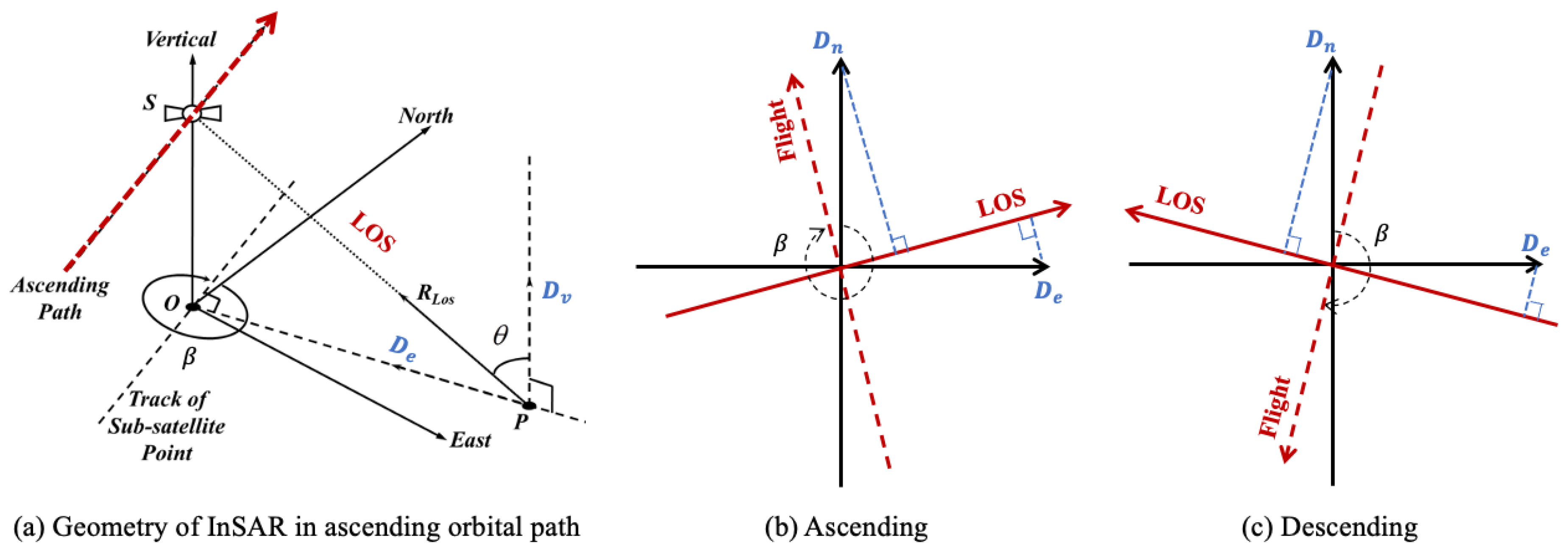
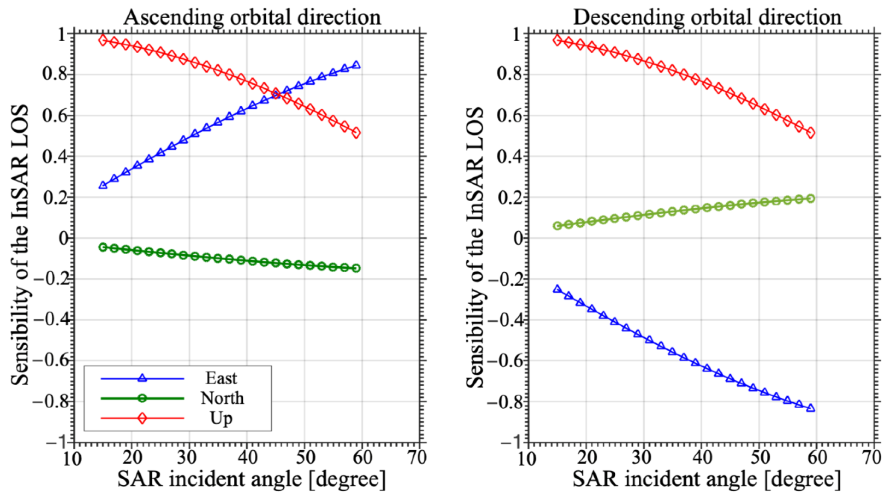
2.3.1. LOS Observation
2.3.2. Geometrical Distortions
2.3.3. Reference Datum
3. Bibliometric Analysis
4. Recent Advances and Applications
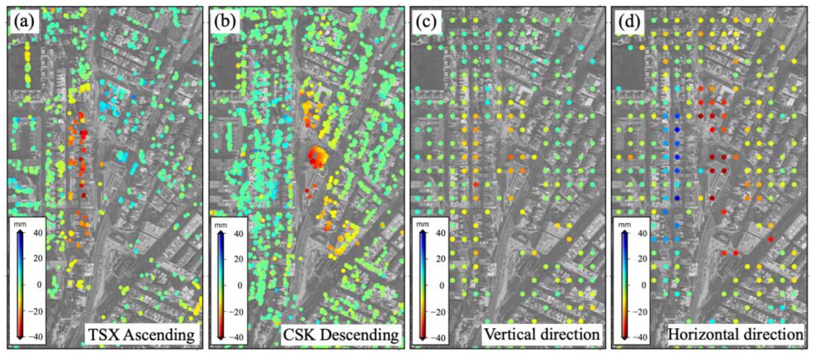
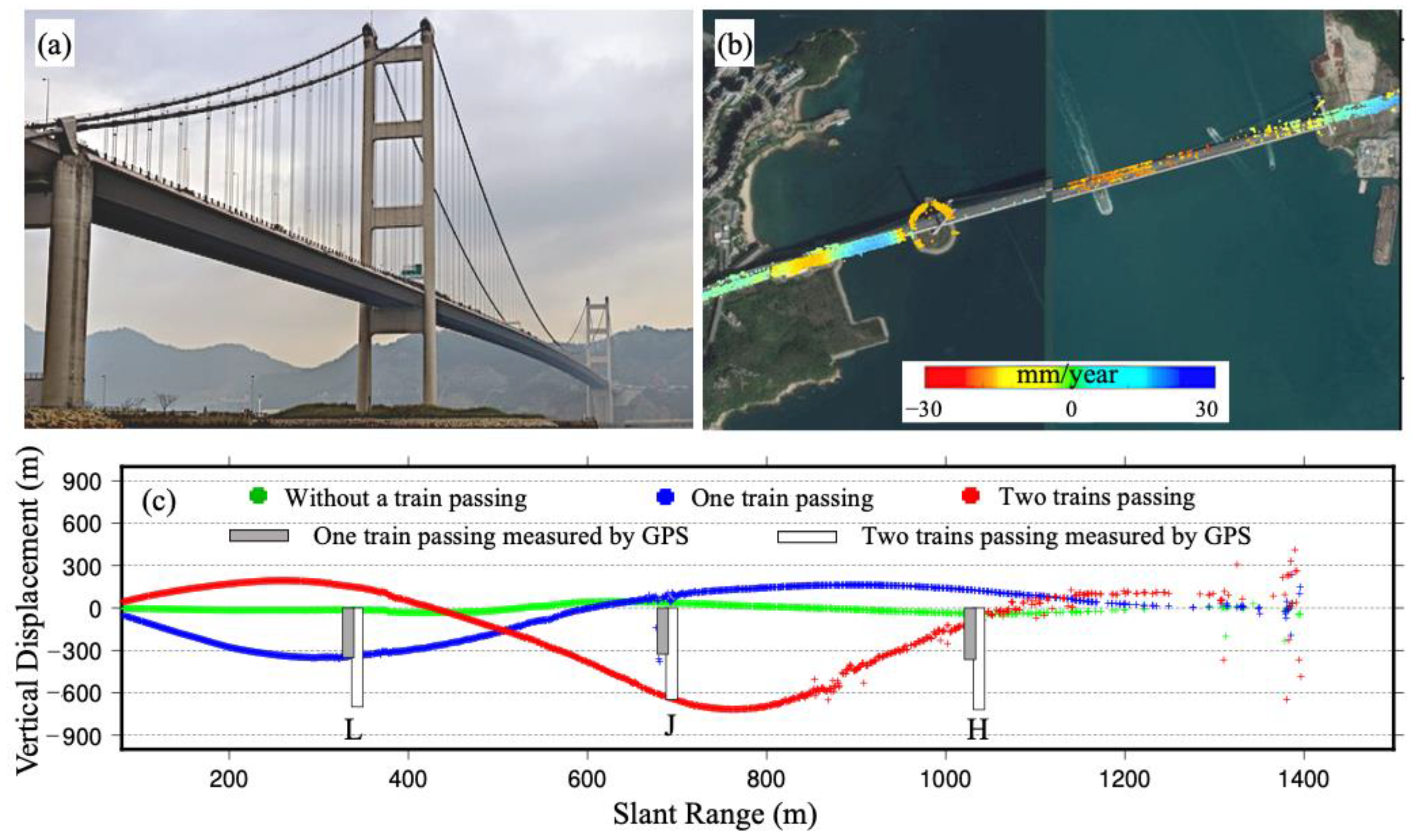
4.1. Monitoring of Multi-Dimensional Deformation of Infrastructure
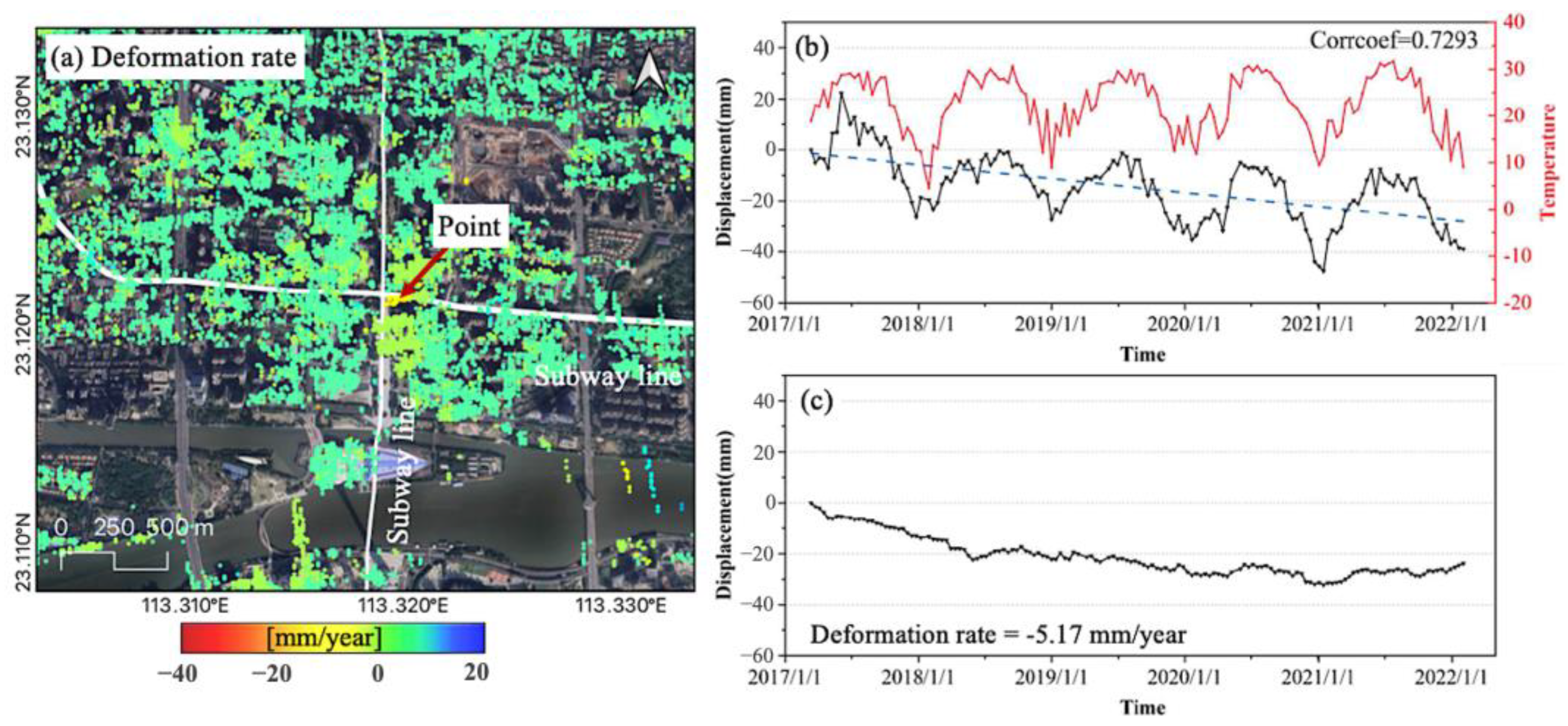
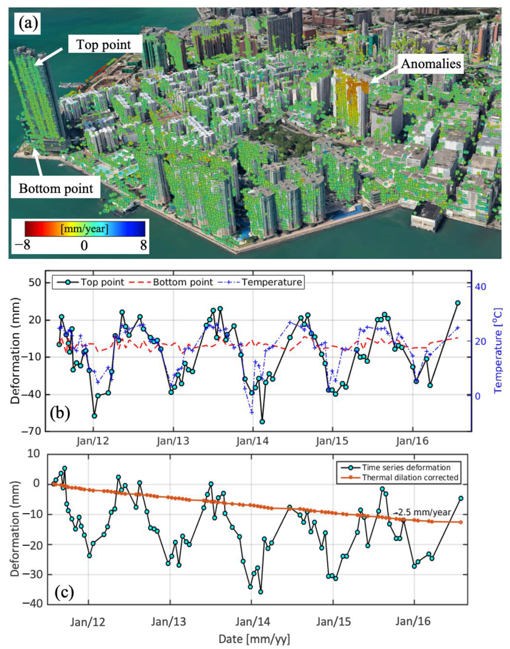
4.2. Detection of Anomalous Deformation of Infrastructures
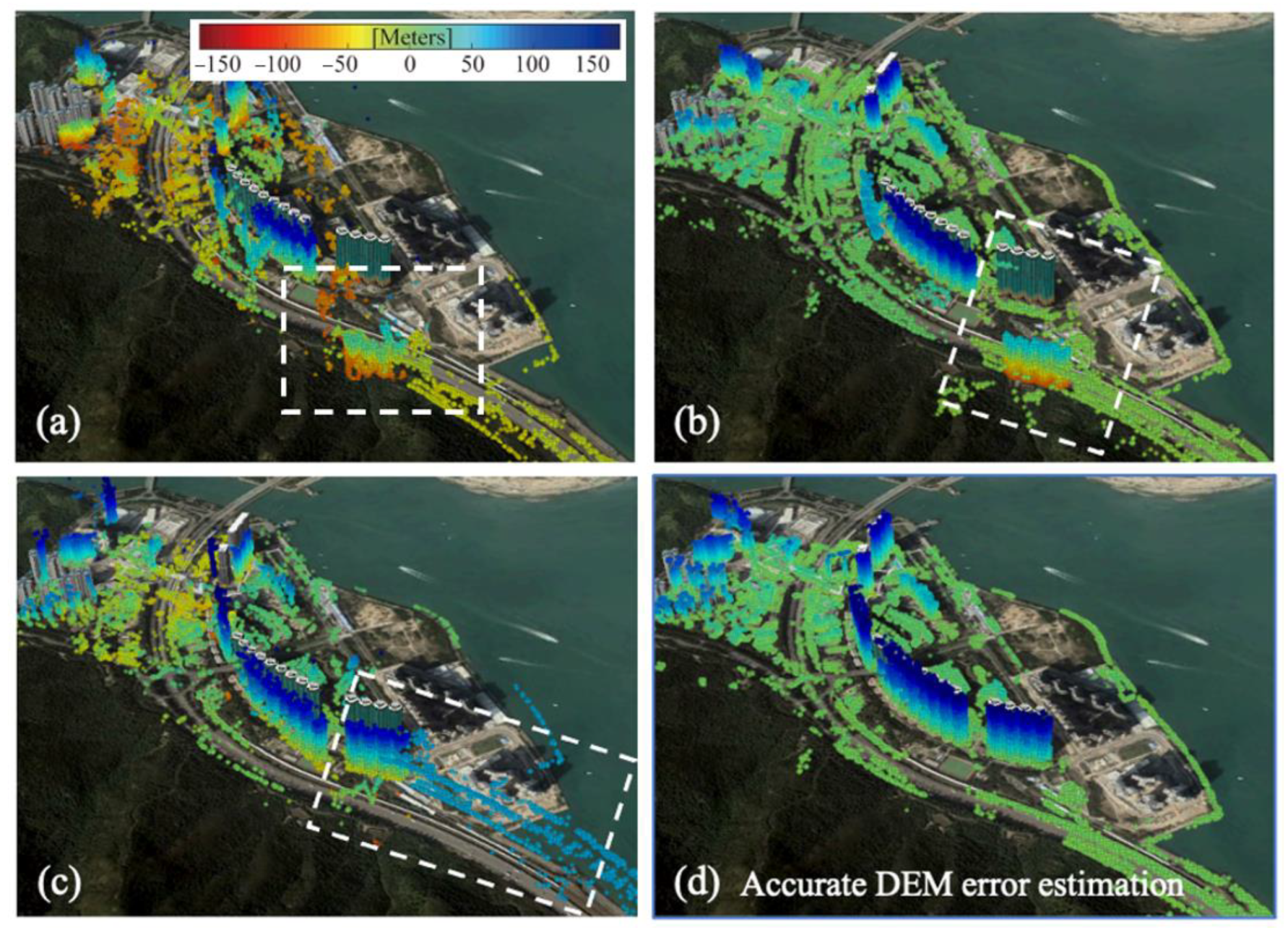
4.3. Accurate 3D Geolocation of Radar Measurements
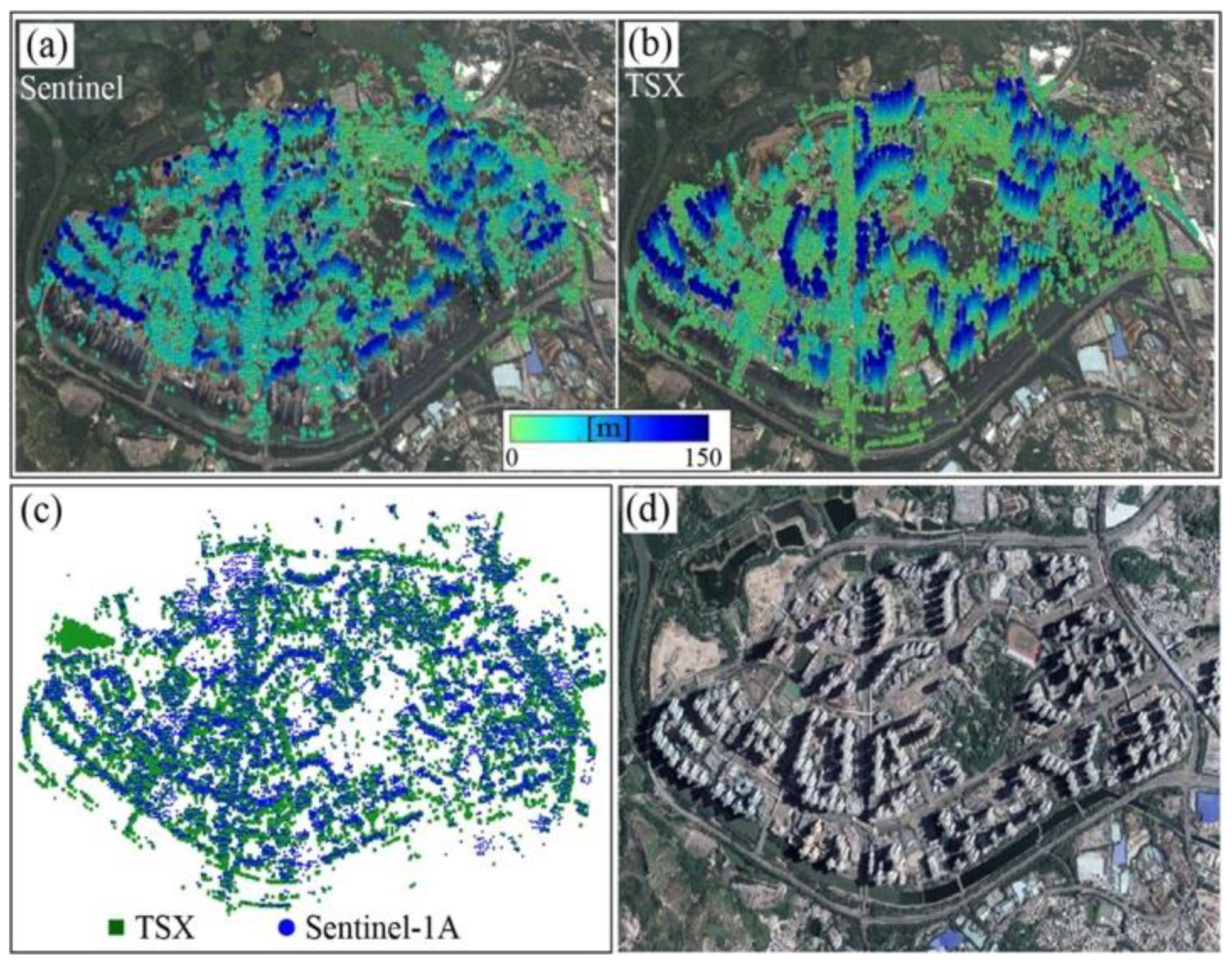
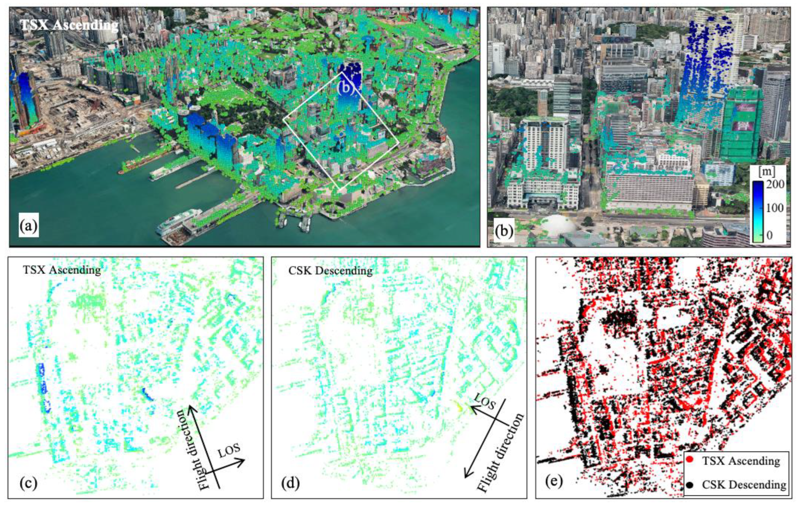
4.4. Utilization of Multi-Platform Radar Interferometric Datasets
4.5. General Survey of Urban Surface Deformation
4.6. Fine Surveillance of Infrastructure Stability
5. Challenges and Future Work
5.1. Challenges
5.1.1. Inconsistent Spatial Distributions of Selected Measurements
5.1.2. Difficulties in Phase Unwrapping
5.1.3. Areas of Rapid Urbanization
5.1.4. Geometric Distortions Caused by Urban Canyons
5.1.5. Appropriate Technology Selection for Structural Deformation Monitoring
5.2. Future Work
- Optimized strategy for radar measurements selection: To enhance the distribution of radar measurements and mitigate the reliance on specific thresholds (see Section 5.1.1), it is advisable to connect the final deformation product requirements with detectable measurement points. For example, monitoring ground deformation caused by activities such as groundwater pumping or engineering construction requires different monitoring accuracy requirements. Therefore, the distribution of usable or detectable measurements points in terms of radar observation quality will change accordingly. In addition, the combined use of multiple radar systems, spaceborne or ground-based, presents an opportunity to improve the integrity of radar measurements in dense urban built-up areas. The integration helps overcome geometric distortions and ensures more complete coverage of the target area.
- Deformation in a rapid urbanization area: The rapid processes of urbanization and urban renewal bring about substantial changes to ground features, resulting in fast decorrelation effects in radar interferometry techniques. It is difficult to maintain the radar interferometry coherence over time, and obtaining ground deformation over a long time in such areas presents significant challenges. It is crucial to develop techniques that can effectively capture ground deformations during the rapid decorrelation periods, as this would provide valuable information. Initial research has been carried out on the exploration of the temporary PS points in [217].
- Development of advanced models and methods: Developing advanced methods is crucial to accurately detect deformation characteristics in urban areas. Tailored techniques such as advanced phase unwrapping can improve measurement quality while compensating for atmospheric effects enhances deformation accuracy. Additionally, different infrastructures in urban areas have varying deformation characteristics. By combining engineering models, we can differentiate between normal deformation and anomalous deformation, leading to improved detection accuracy. Furthermore, integrating engineering models to interpret measurement results, such as establishing the normal range of deformation for a structure, is crucial.
- Efficient data processing strategies: Efficient data processing is crucial for long-term urban infrastructure monitoring. To achieve this, more efficient processing methods for both spaceborne and ground-based systems should be investigated and adopted, e.g., sequential estimators [211,218]. These methods should facilitate timely updates of interferometric measurements as new data become available. This is especially vital when dealing with extensive study areas with large SAR datasets. In addition, precise repositioning of the GBRI system is also essential for long-term deformation monitoring as discussed in Section 2 [105,106,219]. If the instrument pillar cannot be built to maintain a stable observation position, it is very important to develop repositioning error correction methods to ensure accuracy.
- Improved interpretation of deformation products: Radar interferometry provides valuable information about infrastructure deformation, but the interpretation of results can be nonintuitive, hindering its proper utilization, especially among non-experts. Enhancing the interpretation and data mining of deformation results with multidisciplinary knowledge can improve understanding. The development of artificial intelligence (AI) techniques for the automatic interpretation of deformation data can make them more accessible to a wider audience and facilitate effective utilization; similar research has been carried out in geohazard monitoring [220,221].
6. Conclusions
- (1)
- Both spaceborne InSAR and GBRI have been widely used for the urban infrastructure deformation monitoring. The applications have been increasing over the recent decades, in particular over the recent 10 years.
- (2)
- Recent advances and applications of both spaceborne InSAR and GBRI techniques in urban infrastructure deformation monitoring were discussed. These include multi-dimensional deformation monitoring, multi-platform SAR datasets, anomalous deformation detection, accurate 3D geolocation of measurements, general survey of urban surface deformation, and surveillance of infrastructure stability.
- (3)
- Several challenges in monitoring urban infrastructure deformation using radar interferometry were identified. These include the inconsistence in the distribution of selected measurements from different methods, difficulties in phase unwrapping in urban areas, rapid decorrelation, geometric distortions, and technology selection in monitoring highly dynamic infrastructures. The potential future research directions in both spaceborne InSAR and GBRI for infrastructure deformation monitoring were also discussed, including an optimization strategy for radar measurements selection, long-term deformation monitoring, monitoring deformation in areas of rapid urbanization and geometric distortions, efficient data processing strategies, and better interpretation of deformation measurement results.
Author Contributions
Funding
Institutional Review Board Statement
Informed Consent Statement
Data Availability Statement
Acknowledgments
Conflicts of Interest
References
- O’Neill, M.W.; Sarhan, H.A. Structural resistance factors for drilled shafts considering construction flaws. In Current Practices and Future Trends in Deep Foundations; ASCE Library: Lawrence, KS, USA, 2004; pp. 166–185. [Google Scholar]
- Khotamov, A.T. Influence of the Intensity of Physical Wear and Tear on the Durability of Multi-Apartment Residential Buildings. Ann. For. Res. 2022, 65, 9839–9848. [Google Scholar]
- McCall, G. Geohazards and the urban environment. Geol. Soc. Lond. Eng. Geol. Spec. Publ. 1998, 15, 309–318. [Google Scholar] [CrossRef]
- Bianchini, S.; Pratesi, F.; Nolesini, T.; Casagli, N. Building deformation assessment by means of persistent scatterer interferometry analysis on a landslide-affected area: The Volterra (Italy) case study. Remote Sens. 2015, 7, 4678–4701. [Google Scholar] [CrossRef]
- Brinkmann, R.; Parise, M.; Dye, D. Sinkhole distribution in a rapidly developing urban environment: Hillsborough County, Tampa Bay area, Florida. Eng. Geol. 2008, 99, 169–184. [Google Scholar] [CrossRef]
- Hunter, G.; Fell, R. The Deformation Behaviour of Embankment Dams; University of New South Wales, School of Civil and Environmental Engineering: Sydney, NSW, Australia, 2003. [Google Scholar]
- Sony, S.; Laventure, S.; Sadhu, A. A literature review of next-generation smart sensing technology in structural health monitoring. Struct. Control Health Monit. 2019, 26, e2321. [Google Scholar] [CrossRef]
- Ansari, F. Sensing Issues in Civil Structural Health Monitoring; Springer: Berlin/Heidelberg, Germany, 2005; Volume 1. [Google Scholar]
- Pratesi, F.; Tapete, D.; Terenzi, G.; Del Ventisette, C.; Moretti, S. Rating health and stability of engineering structures via classification indexes of InSAR Persistent Scatterers. Int. J. Appl. Earth Obs. Geoinf. 2015, 40, 81–90. [Google Scholar] [CrossRef]
- Giardina, G.; Milillo, P.; DeJong, M.J.; Perissin, D.; Milillo, G. Evaluation of InSAR monitoring data for post-tunnelling settlement damage assessment. Struct. Control Health Monit. 2019, 26, e2285. [Google Scholar] [CrossRef]
- Milillo, P.; Perissin, D.; Salzer, J.T.; Lundgren, P.; Lacava, G.; Milillo, G.; Serio, C. Monitoring dam structural health from space: Insights from novel InSAR techniques and multi-parametric modeling applied to the Pertusillo dam Basilicata, Italy. Int. J. Appl. Earth Obs. Geoinf. 2016, 52, 221–229. [Google Scholar] [CrossRef]
- Chang, L. Monitoring Civil Infrastructure Using Satellite Radar Interferometry. Ph.D. Thesis, Delft University of Technology, Delft, The Netherlands, 2015. [Google Scholar]
- Strozzi, T.; Wegmuller, U.; Werner, C.; Wiesmann, A. Measurement of slow uniform surface displacement with mm/year accuracy. In IGARSS 2000, Proceedings of the IEEE 2000 International Geoscience and Remote Sensing Symposium, Taking the Pulse of the Planet: The Role of Remote Sensing in Managing the Environment, Honolulu, HI, USA, 24–28 July 2000; Proceedings (Cat. No. 00CH37120); IEEE: Piscataway, NJ, USA; pp. 2239–2241.
- Ferretti, A.; Savio, G.; Barzaghi, R.; Borghi, A.; Musazzi, S.; Novali, F.; Prati, C.; Rocca, F. Submillimeter accuracy of InSAR time series: Experimental validation. IEEE Trans. Geosci. Remote Sens. 2007, 45, 1142–1153. [Google Scholar] [CrossRef]
- Ghuman, B.T.R.a.P. Automated generation of near realtime, optimum accuracy movement products with Sentinel-1A IW data. In Proceedings of the FRINGE 15 Meeting, Frascati, Italy, 23–27 March 2015. [Google Scholar]
- Wasowski, J.; Pisano, L. Long-term InSAR, borehole inclinometer, and rainfall records provide insight into the mechanism and activity patterns of an extremely slow urbanized landslide. Landslides 2020, 17, 445–457. [Google Scholar] [CrossRef]
- Bennett, A.; Blacknell, D. Infrastructure analysis from high resolution SAR and InSAR imagery. In Proceedings of the 2003 2nd GRSS/ISPRS Joint Workshop on Remote Sensing and Data Fusion over Urban Areas, Berlin, Germany, 22–23 May 2003; pp. 230–235. [Google Scholar]
- Lin, H.; Ma, P.; Wang, W. Urban Infrastructure Health Monitoring with Spaceborne Multi-temporal Synthetic Aperture Radar Interferometry. Acta Geod. Cartogr. Sin. 2017, 46, 1421–1433. [Google Scholar]
- Crosetto, M.; Monserrat, O.; Herrera, G. Urban applications of persistent scatterer interferometry. In Radar Remote Sensing of Urban Areas; Springer: Berlin/Heidelberg, Germany, 2010; pp. 233–248. [Google Scholar]
- Peduto, D.; Oricchio, L.; Nicodemo, G.; Crosetto, M.; Ripoll, J.; Buxó, P.; Janeras, M. Investigating the kinematics of the unstable slope of Barberà de la Conca (Catalonia, Spain) and the effects on the exposed facilities by GBSAR and multi-source conventional monitoring. Landslides 2021, 18, 457–469. [Google Scholar] [CrossRef]
- Noferini, L.; Pieraccini, M.; Mecatti, D.; Macaluso, G.; Atzeni, C.; Mantovani, M.; Marcato, G.; Pasuto, A.; Silvano, S.; Tagliavini, F. Using GB-SAR technique to monitor slow moving landslide. Eng. Geol. 2007, 95, 88–98. [Google Scholar] [CrossRef]
- Kuras, P.; Ortyl, Ł.; Owerko, T.; Salamak, M.; Łaziński, P. GB-SAR in the diagnosis of critical city infrastructure—A case study of a load test on the long tram extradosed bridge. Remote Sens. 2020, 12, 3361. [Google Scholar] [CrossRef]
- Ma, P.; Lin, H.; Wang, W.; Yu, H.; Chen, F.; Jiang, L.; Zhou, L.; Zhang, Z.; Shi, G.; Wang, J. Toward Fine Surveillance: A Review of Multitemporal Interferometric Synthetic Aperture Radar for Infrastructure Health Monitoring. IEEE Geosci. Remote Sens. Mag. 2021, 10, 207–230. [Google Scholar] [CrossRef]
- Monserrat, O.; Crosetto, M.; Luzi, G. A review of ground-based SAR interferometry for deformation measurement. ISPRS J. Photogramm. Remote Sens. 2014, 93, 40–48. [Google Scholar] [CrossRef]
- Skolnik, M.I. Introduction to Radar Systems; McGraw-Hill Education: New York, NY, USA, 1980. [Google Scholar]
- Bamler, R. Principles of synthetic aperture radar. Surv. Geophys. 2000, 21, 147–157. [Google Scholar] [CrossRef]
- Massonnet, D.; Souyris, J.-C. Imaging with Synthetic Aperture Radar; EPFL Press: Lausanne, Switzerland, 2008. [Google Scholar]
- Oliver, C.; Quegan, S. Understanding Synthetic Aperture Radar Images; SciTech Publishing: Chennai, India, 2004. [Google Scholar]
- Bamler, R.; Hartl, P. Synthetic aperture radar interferometry. Inverse Probl. 1998, 14, R1. [Google Scholar] [CrossRef]
- Massonnet, D.; Feigl, K.L. Radar interferometry and its application to changes in the Earth’s surface. Rev. Geophys. 1998, 36, 441–500. [Google Scholar] [CrossRef]
- Hanssen, R.F. Radar Interferometry: Data Interpretation and Error Analysis; Springer Science & Business Media: Berlin/Heidelberg, Germany, 2001; Volume 2. [Google Scholar]
- Hanssen, R.; Bamler, R. Evaluation of interpolation kernels for SAR interferometry. IEEE Trans. Geosci. Remote Sens. 1999, 37, 318–321. [Google Scholar] [CrossRef]
- Li, Z.; Bethel, J. Image coregistration in SAR interferometry. The International Archives of the Photogrammetry. Remote Sens. Spat. Inf. Sci. 2008, 37, 433–438. [Google Scholar]
- Pepe, A.; Solaro, G.; Calo, F.; Dema, C. A minimum acceleration approach for the retrieval of multiplatform InSAR deformation time series. IEEE J. Sel. Top. Appl. Earth Obs. Remote Sens. 2016, 9, 3883–3898. [Google Scholar] [CrossRef]
- Zebker, H.A.; Goldstein, R.M. Topographic mapping from interferometric synthetic aperture radar observations. J. Geophys. Res. Solid Earth 1986, 91, 4993–4999. [Google Scholar] [CrossRef]
- Goldstein, R.M.; Zebker, H.A.; Werner, C.L. Satellite radar interferometry: Two-dimensional phase unwrapping. Radio Sci. 1988, 23, 713–720. [Google Scholar] [CrossRef]
- Costantini, M. A novel phase unwrapping method based on network programming. IEEE Trans. Geosci. Remote Sens. 1998, 36, 813–821. [Google Scholar] [CrossRef]
- Bock, Y.; Williams, S. Integrated satellite interferometry in southern California. Eos Trans. Am. Geophys. Union 1997, 78, 293–300. [Google Scholar] [CrossRef]
- Klees, R.; Massonnet, D. Deformation measurements using SAR interferometry: Potential and limitations. Geol. Mijnb. 1999, 77, 161–176. [Google Scholar] [CrossRef]
- Beauducel, F.; Briole, P.; Froger, J.L. Volcano-wide fringes in ERS synthetic aperture radar interferograms of Etna (1992–1998): Deformation or tropospheric effect? J. Geophys. Res. Solid Earth 2000, 105, 16391–16402. [Google Scholar] [CrossRef]
- Hanssen, R.; Moisseev, D.; Businger, S. Resolving the acquisition ambiguity for atmospheric monitoring in multi-pass radar interferometry. In IGARSS 2003, Proceedings of the 2003 IEEE International Geoscience and Remote Sensing Symposium, Toulouse, France, 21–25 July 2003; Proceedings (IEEE Cat. No.03CH37477); IEEE: Piscataway, NJ, USA; pp. 1202–1205.
- Simons, M.; Fialko, Y.; Rivera, L. Coseismic deformation from the 1999 M w 7.1 Hector Mine, California, earthquake as inferred from InSAR and GPS observations. Bull. Seismol. Soc. Am. 2002, 92, 1390–1402. [Google Scholar] [CrossRef]
- Sandwell, D.T.; Price, E.J. Phase gradient approach to stacking interferograms. J. Geophys. Res. Solid Earth 1998, 103, 30183–30204. [Google Scholar] [CrossRef]
- Ferretti, A.; Prati, C.; Rocca, F. Nonlinear subsidence rate estimation using permanent scatterers in differential SAR interferometry. IEEE Trans. Geosci. Remote Sens. 2000, 38, 2202–2212. [Google Scholar] [CrossRef]
- Ferretti, A.; Prati, C.; Rocca, F. Permanent scatterers in SAR interferometry. IEEE Trans. Geosci. Remote Sens. 2001, 39, 8–20. [Google Scholar] [CrossRef]
- Berardino, P.; Fornaro, G.; Lanari, R.; Sansosti, E. A new algorithm for surface deformation monitoring based on small baseline differential SAR interferograms. IEEE Trans. Geosci. Remote Sens. 2002, 40, 2375–2383. [Google Scholar] [CrossRef]
- Hooper, A. A multi-temporal InSAR method incorporating both persistent scatterer and small baseline approaches. Geophys. Res. Lett. 2008, 35, L16302. [Google Scholar] [CrossRef]
- Ferretti, A.; Fumagalli, A.; Novali, F.; Prati, C.; Rocca, F.; Rucci, A. A new algorithm for processing interferometric data-stacks: SqueeSAR. IEEE Trans. Geosci. Remote Sens. 2011, 49, 3460–3470. [Google Scholar] [CrossRef]
- Werner, C.; Wegmuller, U.; Strozzi, T.; Wiesmann, A. Interferometric point target analysis for deformation mapping. In IGARSS 2003, Proceedings of the 2003 IEEE International Geoscience and Remote Sensing Symposium, Toulouse, France, 21–25 July 2003; Proceedings (IEEE Cat. No.03CH37477); IEEE: Piscataway, NJ, USA; pp. 4362–4364.
- Zhang, L.; Ding, X.; Lu, Z. Ground settlement monitoring based on temporarily coherent points between two SAR acquisitions. ISPRS J. Photogramm. Remote Sens. 2011, 66, 146–152. [Google Scholar] [CrossRef]
- Hooper, A.; Zebker, H.; Segall, P.; Kampes, B. A new method for measuring deformation on volcanoes and other natural terrains using InSAR persistent scatterers. Geophys. Res. Lett. 2004, 31, L23611. [Google Scholar] [CrossRef]
- Li, T.; Liu, G.; Lin, H.; Jia, H.; Zhang, R.; Yu, B.; Luo, Q. A hierarchical multi-temporal InSAR method for increasing the spatial density of deformation measurements. Remote Sens. 2014, 6, 3349–3368. [Google Scholar] [CrossRef]
- Ojha, C.; Manunta, M.; Lanari, R.; Pepe, A. The Constrained-Network Propagation (C-NetP) Technique to Improve SBAS-DInSAR Deformation Time Series Retrieval. IEEE J. Sel. Top. Appl. Earth Obs. Remote Sens. 2015, 8, 4910–4921. [Google Scholar] [CrossRef]
- Kampes, B.M. Radar Interferometry; Springer: Berlin/Heidelberg, Germany, 2006. [Google Scholar]
- Pepe, A.; Lanari, R. On the extension of the minimum cost flow algorithm for phase unwrapping of multitemporal differential SAR interferograms. IEEE Trans. Geosci. Remote Sens. 2006, 44, 2374–2383. [Google Scholar] [CrossRef]
- Zhang, L.; Ding, X.; Lu, Z. Modeling PSInSAR time series without phase unwrapping. IEEE Trans. Geosci. Remote Sens. 2011, 49, 547–556. [Google Scholar] [CrossRef]
- Flynn, T.J. Two-dimensional phase unwrapping with minimum weighted discontinuity. JOSA A 1997, 14, 2692–2701. [Google Scholar] [CrossRef]
- Ghiglia, D.C.; Romero, L.A. Robust two-dimensional weighted and unweighted phase unwrapping that uses fast transforms and iterative methods. JOSA A 1994, 11, 107–117. [Google Scholar] [CrossRef]
- Fattahi, H.; Amelung, F. DEM error correction in InSAR time series. IEEE Trans. Geosci. Remote Sens. 2013, 51, 4249–4259. [Google Scholar] [CrossRef]
- Chang, L.; Hanssen, R.F. A probabilistic approach for InSAR time-series postprocessing. IEEE Trans. Geosci. Remote Sens. 2015, 54, 421–430. [Google Scholar] [CrossRef]
- Baehr, H. Orbital Effects in Spaceborne Synthetic Aperture Radar Interferometry; KIT Scientific Publishing: Karlsruhe, Deutschand, 2013. [Google Scholar]
- Fattahi, H.; Amelung, F. InSAR uncertainty due to orbital errors. Geophys. J. Int. 2014, 199, 549–560. [Google Scholar] [CrossRef]
- Mancon, S.; Guarnieri, A.M.; Tebaldini, S.; Giudici, D. Orbital error estimation through multi-squint analysis. In EUSAR 2014, Proceedings of the 10th European Conference on Synthetic Aperture Radar, Berlin, Germany, 3–5 June 2014; IEEE: Piscataway, NJ, USA; pp. 1–4.
- Zhang, L.; Ding, X.; Lu, Z.; Jung, H.-S.; Hu, J.; Feng, G. A novel multitemporal InSAR model for joint estimation of deformation rates and orbital errors. IEEE Trans. Geosci. Remote Sens. 2014, 52, 3529–3540. [Google Scholar] [CrossRef]
- Cao, Y.; Li, Z.; Wei, J.; Hu, J.; Duan, M.; Feng, G. Stochastic modeling for time series InSAR: With emphasis on atmospheric effects. J. Geod. 2018, 92, 185–204. [Google Scholar] [CrossRef]
- Yu, C.; Li, Z.; Penna, N.T.; Crippa, P. Generic atmospheric correction model for Interferometric Synthetic Aperture Radar observations. J. Geophys. Res. Solid Earth 2018, 123, 9202–9222. [Google Scholar] [CrossRef]
- Liang, H.; Zhang, L.; Lu, Z.; Li, X. Correction of spatially varying stratified atmospheric delays in multitemporal InSAR. Remote Sens. Environ. 2023, 285, 113382. [Google Scholar] [CrossRef]
- Duan, M.; Xu, B.; Li, Z.; Wu, W.; Cao, Y.; Liu, J.; Wang, G.; Hou, J. A new weighting method by considering the physical characteristics of atmospheric turbulence and decorrelation noise in SBAS-InSAR. Remote Sens. 2020, 12, 2557. [Google Scholar] [CrossRef]
- Crosetto, M.; Devanthéry, N.; Monserrat, O.; Barra, A.; Cuevas-González, M.; Mróz, M.; Botey-Bassols, J.; Vázquez-Suñé, E.; Crippa, B. A persistent scatterer interferometry procedure based on stable areas to filter the atmospheric component. Remote Sens. 2018, 10, 1780. [Google Scholar] [CrossRef]
- Jung, H.-S.; Lee, D.-T.; Lu, Z.; Won, J.-S. Ionospheric correction of SAR interferograms by multiple-aperture interferometry. IEEE Trans. Geosci. Remote Sens. 2012, 51, 3191–3199. [Google Scholar] [CrossRef]
- Gomba, G.; Parizzi, A.; De Zan, F.; Eineder, M.; Bamler, R. Toward operational compensation of ionospheric effects in SAR interferograms: The split-spectrum method. IEEE Trans. Geosci. Remote Sens. 2015, 54, 1446–1461. [Google Scholar] [CrossRef]
- Zhang, B.; Wang, C.; Ding, X.; Zhu, W.; Wu, S. Correction of ionospheric artifacts in SAR data: Application to fault slip inversion of 2009 Southern Sumatra Earthquake. IEEE Geosci. Remote Sens. Lett. 2018, 15, 1327–1331. [Google Scholar] [CrossRef]
- Zhang, B.; Ding, X.; Amelung, F.; Wang, C.; Xu, W.; Zhu, W.; Shimada, M.; Zhang, Q.; Baba, T. Impact of ionosphere on InSAR observation and coseismic slip inversion: Improved slip model for the 2010 Maule, Chile, earthquake. Remote Sens. Environ. 2021, 267, 112733. [Google Scholar] [CrossRef]
- Liang, H.; Zhang, L.; Lu, Z.; Li, X. Nonparametric Estimation of DEM Error in Multitemporal InSAR. IEEE Trans. Geosci. Remote Sens. 2019, 57, 10004–10014. [Google Scholar] [CrossRef]
- Zhang, W.; Zhu, W.; Tian, X.; Zhang, Q.; Zhao, C.; Niu, Y.; Wang, C. Improved DEM Reconstruction Method Based on Multibaseline InSAR. IEEE Geosci. Remote Sens. Lett. 2021, 19, 4011505. [Google Scholar] [CrossRef]
- Wang, T.; Jónsson, S.; Hanssen, R.F. Improved SAR image coregistration using pixel-offset series. IEEE Geosci. Remote Sens. Lett. 2014, 11, 1465–1469. [Google Scholar] [CrossRef]
- Natsuaki, R.; Hirose, A. InSAR local co-registration method assisted by shape-from-shading. IEEE J. Sel. Top. Appl. Earth Obs. Remote Sens. 2012, 6, 953–959. [Google Scholar] [CrossRef]
- Refice, A.; Bovenga, F.; Nutricato, R. MST-based stepwise connection strategies for multipass radar data, with application to coregistration and equalization. IEEE Trans. Geosci. Remote Sens. 2006, 44, 2029–2040. [Google Scholar] [CrossRef]
- Xu, B.; Li, Z.; Zhu, Y.; Shi, J.; Feng, G. Kinematic coregistration of sentinel-1 TOPSAR images based on sequential least squares adjustment. IEEE J. Sel. Top. Appl. Earth Obs. Remote Sens. 2020, 13, 3083–3093. [Google Scholar] [CrossRef]
- Pinel-Puysségur, B.; Lasserre, C.; Benoit, A.; Jolivet, R.; Doin, M.-P.; Champenois, J. A simple phase unwrapping errors correction algorithm based on phase closure analysis. In Proceedings of the IGARSS 2018–2018 IEEE International Geoscience and Remote Sensing Symposium, Valencia, Spain, 22–27 July 2018; pp. 2212–2215. [Google Scholar]
- Zhang, Y.; Heresh, F.; Falk, A. Small baseline InSAR time series analysis: Unwrapping error correction and noise reduction. Comput. Geosci. 2019, 133, 104331. [Google Scholar]
- Wu, S.; Zhang, B.; Ding, X.; Shahzad, N.; Zhang, L.; Lu, Z. A hybrid method for MT-InSAR phase unwrapping for deformation monitoring in urban areas. Int. J. Appl. Earth Obs. Geoinf. 2022, 112, 102963. [Google Scholar] [CrossRef]
- Yang, M.; Dheenathayalan, P.; López-Dekker, P.; van Leijen, F.; Liao, M.; Hanssen, R.F. On the influence of sub-pixel position correction for PS localization accuracy and time series quality. ISPRS J. Photogramm. Remote Sens. 2020, 165, 98–107. [Google Scholar] [CrossRef]
- Yang, M.; López-Dekker, P.; Dheenathayalan, P.; Liao, M.; Hanssen, R.F. On the value of corner reflectors and surface models in InSAR precise point positioning. ISPRS J. Photogramm. Remote Sens. 2019, 158, 113–122. [Google Scholar] [CrossRef]
- Hooper, A.J. Persistent Scatter Radar Interferometry for Crustal Deformation Studies and Modeling of Volcanic Deformation; Stanford University: Stanford, CA, USA, 2006. [Google Scholar]
- Blanco-Sànchez, P.; Mallorquí, J.J.; Duque, S.; Monells, D. The Coherent Pixels Technique (CPT): An Advanced DInSAR Technique for Nonlinear Deformation Monitoring. In Earth Sciences and Mathematics: Volume 1; Camacho, A.G., Díaz, J.I., Fernández, J., Eds.; Birkhäuser Basel: Basel, Switzerland, 2008; pp. 1167–1193. [Google Scholar]
- Costantini, M.; Falco, S.; Malvarosa, F.; Minati, F.; Trillo, F.; Vecchioli, F. Persistent scatterer pair interferometry: Approach and application to COSMO-SkyMed SAR data. IEEE J. Sel. Top. Appl. Earth Obs. Remote Sens. 2014, 7, 2869–2879. [Google Scholar] [CrossRef]
- Wu, S.; Zhang, L.; Ding, X.; Perissin, D. Pixel-Wise MTInSAR Estimator for Integration of Coherent Point Selection and Unwrapped Phase Vector Recovery. IEEE Trans. Geosci. Remote Sens. 2019, 57, 2659–2668. [Google Scholar] [CrossRef]
- Fornaro, G.; Verde, S.; Reale, D.; Pauciullo, A. CAESAR: An approach based on covariance matrix decomposition to improve multibaseline–multitemporal interferometric SAR processing. IEEE Trans. Geosci. Remote Sens. 2015, 53, 2050–2065. [Google Scholar] [CrossRef]
- Dong, J.; Zhang, L.; Tang, M.; Liao, M.; Xu, Q.; Gong, J.; Ao, M. Mapping landslide surface displacements with time series SAR interferometry by combining persistent and distributed scatterers: A case study of Jiaju landslide in Danba, China. Remote Sens. Environ. 2018, 205, 180–198. [Google Scholar] [CrossRef]
- Lazecký, M.; Spaans, K.; González, P.J.; Maghsoudi, Y.; Morishita, Y.; Albino, F.; Elliott, J.; Greenall, N.; Hatton, E.; Hooper, A. LiCSAR: An automatic InSAR tool for measuring and monitoring tectonic and volcanic activity. Remote Sens. 2020, 12, 2430. [Google Scholar] [CrossRef]
- Zhu, X.X.; Bamler, R. Very high resolution spaceborne SAR tomography in urban environment. IEEE Trans. Geosci. Remote Sens. 2010, 48, 4296–4308. [Google Scholar] [CrossRef]
- Perissin, D.; Wang, T. Repeat-pass SAR interferometry with partially coherent targets. IEEE Trans. Geosci. Remote Sens. 2012, 50, 271–280. [Google Scholar] [CrossRef]
- Caduff, R.; Schlunegger, F.; Kos, A.; Wiesmann, A. A review of terrestrial radar interferometry for measuring surface change in the geosciences. Earth Surf. Process. Landf. 2015, 40, 208–228. [Google Scholar] [CrossRef]
- Pieraccini, M.; Miccinesi, L. Ground-based radar interferometry: A bibliographic review. Remote Sens. 2019, 11, 1029. [Google Scholar] [CrossRef]
- Luzi, G.; Pieraccini, M.; Mecatti, D.; Noferini, L.; Guidi, G.; Moia, F.; Atzeni, C. Ground-based radar interferometry for landslides monitoring: Atmospheric and instrumental decorrelation sources on experimental data. IEEE Trans. Geosci. Remote Sens. 2004, 42, 2454–2466. [Google Scholar] [CrossRef]
- Zheng, X.; Yang, X.; Ma, H.; Ren, G.; Zhang, K.; Yang, F.; Li, C. Integrated ground-based SAR interferometry, terrestrial laser scanner, and corner reflector deformation experiments. Sensors 2018, 18, 4401. [Google Scholar] [CrossRef]
- Deng, Y.; Tian, W.; Xiao, T.; Hu, C.; Yang, H. High-Quality Pixel Selection Applied for Natural Scenes in GB-SAR Interferometry. Remote Sens. 2021, 13, 1617. [Google Scholar] [CrossRef]
- Chao, B.; Zhang, D.; Huang, H. An overview of atmospheric correction for GB-SAR. In Proceedings of the 2019 IEEE 19th International Conference on Communication Technology (ICCT), Xi’an, China, 16–19 October 2019; pp. 1062–1072. [Google Scholar]
- Owerko, T.; Kuras, P.; Ortyl, Ł. Atmospheric correction thresholds for ground-based radar interferometry deformation monitoring estimated using time series analyses. Remote Sens. 2020, 12, 2236. [Google Scholar] [CrossRef]
- Wang, Z.; Li, Z.; Mills, J. A new approach to selecting coherent pixels for ground-based SAR deformation monitoring. ISPRS J. Photogramm. Remote Sens. 2018, 144, 412–422. [Google Scholar] [CrossRef]
- Hu, C.; Deng, Y.; Tian, W.; Wang, J. A PS processing framework for long-term and real-time GB-SAR monitoring. Int. J. Remote Sens. 2019, 40, 6298–6314. [Google Scholar] [CrossRef]
- Yang, H.; Liu, J.; Peng, J.; Wang, J.; Zhao, B.; Zhang, B. A method for GB-InSAR temporal analysis considering the atmospheric correlation in time series. Nat. Hazards 2020, 104, 1465–1480. [Google Scholar] [CrossRef]
- Beni, A.; Miccinesi, L.; Michelini, A.; Pieraccini, M. Temporal coherence estimators for GBSAR. Remote Sens. 2022, 14, 3039. [Google Scholar] [CrossRef]
- Wang, Z.; Li, Z.; Mills, J. Modelling of instrument repositioning errors in discontinuous Multi-Campaign Ground-Based SAR (MC-GBSAR) deformation monitoring. ISPRS J. Photogramm. Remote Sens. 2019, 157, 26–40. [Google Scholar] [CrossRef]
- Hu, C.; Zhu, J.; Deng, Y.; Tian, W.; Yin, P. Repositioning error compensation in discontinuous ground-based SAR monitoring. Remote Sens. 2021, 13, 2461. [Google Scholar] [CrossRef]
- Yang, H.; Cai, J.; Peng, J.; Wang, J.; Jiang, Q. A correcting method about GB-SAR rail displacement. Int. J. Remote Sens. 2017, 38, 1483–1493. [Google Scholar] [CrossRef]
- Lei, T.; Wang, J.; Huang, P.; Tan, W.; Qi, Y.; Xu, W.; Zhao, C. Time-varying baseline error correction method for ground-based micro-deformation monitoring radar. J. Syst. Eng. Electron. 2022, 33, 938–950. [Google Scholar] [CrossRef]
- Takahashi, K.; Matsumoto, M.; Sato, M. Continuous observation of natural-disaster-affected areas using ground-based SAR interferometry. IEEE J. Sel. Top. Appl. Earth Obs. Remote Sens. 2013, 6, 1286–1294. [Google Scholar] [CrossRef]
- Di Pasquale, A.; Corsetti, M.; Guccione, P.; Lugli, A.; Nicoletti, M.; Nico, G.; Zonno, M. Ground-based SAR interferometry as a supporting tool in natural and man-made disasters. In Proceedings of the 33rd EARSel Symposium, Matera, Italy, 3–6 June 2013; pp. 3–6. [Google Scholar]
- Xing, C.; Yu, Z.; Zhou, X.; Wang, P. Research on the testing methods for IBIS-S system. In IOP Conference Series: Earth and Environmental Science; IOP Publishing: Bristol, UK, 2014; p. 012263. [Google Scholar]
- Kuras, P.; Ortyl, Ł.; Owerko, T. Empirical SNR-based model of the displacement accuracy for ground-based radar measurements. ISPRS J. Photogramm. Remote Sens. 2022, 194, 181–194. [Google Scholar] [CrossRef]
- Wright, T.J.; Parsons, B.E.; Lu, Z. Toward mapping surface deformation in three dimensions using InSAR. Geophys. Res. Lett. 2004, 31, L01607. [Google Scholar] [CrossRef]
- Hu, J.; Li, Z.; Ding, X.; Zhu, J.; Zhang, L.; Sun, Q. Resolving three-dimensional surface displacements from InSAR measurements: A review. Earth-Sci. Rev. 2014, 133, 1–17. [Google Scholar] [CrossRef]
- Sun, Q.; Hu, J.; Zhang, L.; Ding, X. Towards slow-moving landslide monitoring by integrating multi-sensor InSAR time series datasets: The Zhouqu case study, China. Remote Sens. 2016, 8, 908. [Google Scholar] [CrossRef]
- Ouchi, K. Recent trend and advance of synthetic aperture radar with selected topics. Remote Sens. 2013, 5, 716–807. [Google Scholar] [CrossRef]
- Osmanoğlu, B.; Sunar, F.; Wdowinski, S.; Cabral-Cano, E. Time series analysis of InSAR data: Methods and trends. ISPRS J. Photogramm. Remote Sens. 2016, 115, 90–102. [Google Scholar] [CrossRef]
- Bhattacharya, A.; Mukherjee, K. Review on InSAR based displacement monitoring of Indian Himalayas: Issues, challenges and possible advanced alternatives. Geocarto Int. 2017, 32, 298–321. [Google Scholar] [CrossRef]
- Casu, F.; Manunta, M.; Agram, P.; Crippen, R. Big Remotely Sensed Data: Tools, applications and experiences. Remote Sens. Environ. 2017, 202, 1–2. [Google Scholar] [CrossRef]
- Pepe, A.; Calò, F. A review of interferometric synthetic aperture RADAR (InSAR) multi-track approaches for the retrieval of Earth’s surface displacements. Appl. Sci. 2017, 7, 1264. [Google Scholar] [CrossRef]
- Even, M.; Schulz, K. InSAR deformation analysis with distributed scatterers: A review complemented by new advances. Remote Sens. 2018, 10, 744. [Google Scholar] [CrossRef]
- Ge, P.; Gokon, H.; Meguro, K. A review on synthetic aperture radar-based building damage assessment in disasters. Remote Sens. Environ. 2020, 240, 111693. [Google Scholar] [CrossRef]
- Minh, D.H.T.; Hanssen, R.; Rocca, F. Radar Interferometry: 20 Years of Development in Time Series Techniques and Future Perspectives. Remote Sens. 2020, 12, 1364. [Google Scholar] [CrossRef]
- Zhang, L.; Ding, X.; Lu, Z. Ground deformation mapping by fusion of multi-temporal interferometric synthetic aperture radar images: A review. Int. J. Image Data Fusion 2015, 6, 289–313. [Google Scholar] [CrossRef]
- Crosetto, M.; Monserrat, O.; Cuevas-González, M.; Devanthéry, N.; Crippa, B. Persistent scatterer interferometry: A review. ISPRS J. Photogramm. Remote Sens. 2016, 115, 78–89. [Google Scholar] [CrossRef]
- Yang, Z.; Li, Z.; Zhu, J.; Wang, Y.; Wu, L. Use of SAR/InSAR in Mining Deformation Monitoring, Parameter Inversion, and Forward Predictions: A Review. IEEE Geosci. Remote Sens. Mag. 2020, 8, 71–90. [Google Scholar] [CrossRef]
- Talledo, D.A.; Miano, A.; Bonano, M.; Di Carlo, F.; Lanari, R.; Manunta, M.; Meda, A.; Mele, A.; Prota, A.; Saetta, A. Satellite radar interferometry: Potential and limitations for structural assessment and monitoring. J. Build. Eng. 2022, 46, 103756. [Google Scholar] [CrossRef]
- Chen, Y.; Zhang, G.; Ding, X.; Li, Z. Monitoring earth surface deformations with InSAR technology: Principles and some critical issues. J. Geospat. Eng. 2000, 2, 3–22. [Google Scholar]
- Gabriel, A.K.; Goldstein, R.M.; Zebker, H.A. Mapping small elevation changes over large areas: Differential radar interferometry. J. Geophys. Res. Solid Earth 1989, 94, 9183–9191. [Google Scholar] [CrossRef]
- Massonnet, D.; Rossi, M.; Carmona, C.; Adragna, F.; Peltzer, G.; Feigl, K.; Rabaute, T. The displacement field of the Landers earthquake mapped by radar interferometry. Nature 1993, 364, 138–142. [Google Scholar] [CrossRef]
- Massonnet, D.; Briole, P.; Arnaud, A. Deflation of Mount Etna monitored by spaceborne radar interferometry. Nature 1995, 375, 567–570. [Google Scholar] [CrossRef]
- Crosetto, M.; Castillo, M.; Arbiol, R. Urban subsidence monitoring using radar interferometry. Photogramm. Eng. Remote Sens. 2003, 69, 775–783. [Google Scholar] [CrossRef]
- Carnec, C.; Massonnet, D.; King, C. Two examples of the use of SAR interferometry on displacement fields of small spatial extent. Geophys. Res. Lett. 1996, 23, 3579–3582. [Google Scholar] [CrossRef]
- Wang, C.; Zhang, H.; Liu, Z. ERS-1/2 SAR interferometry for urban subsidence detection in China. ESA SP 2000, 461, 2186–2191. [Google Scholar]
- Carnec, C.; Raucoules, D. Assessement of SAR interferometry within operational application: Mapping and modelling of peri-urban subsidence. In Proceedings of the ESA-ENVISAT Symposium, Gothenburg, Sweden, 16–20 October 2000; Number SP-461.532. pp. 1–5. [Google Scholar]
- Tesauro, M.; Berardino, P.; Lanari, R.; Sansosti, E.; Fornaro, G.; Franceschetti, G. Urban subsidence inside the city of Napoli (Italy) observed by satellite radar interferometry. Geophys. Res. Lett. 2000, 27, 1961–1964. [Google Scholar] [CrossRef]
- Cabral-Cano, E.; Dixon, T.; Sánchez, O. InSAR and GPS Analysis of Ground Subsidence in Mexico City. In Proceedings of the AGU Fall Meeting Abstracts, Washington, DC, USA, 2 August 2002; p. G61B–0980. [Google Scholar]
- Thierry, P.; Deverly, F.; Reppelin, M.; Simonetto, E.; Lembezat, C.; Arnaud, A.; Raucoules, D.; Closset, L.; King, C. Survey of linear subsidence in an urban area using a 3D geological model and satellite Differential InSAR. In Proceedings of the Géoline Conference, Lyon, France, 23–25 May 2005. [Google Scholar]
- Kim, J.-s.; Kim, D.-J.; Kim, S.-W.; Won, J.-S.; Moon, W.M. Monitoring of urban land surface subsidence using PSInSAR. Geosci. J. 2007, 11, 59–73. [Google Scholar] [CrossRef]
- Stevens, N.F.; Glassey, P.; Lyttle, B.S. Slope Instability and Surface Deformation in Dunedin City, New Zealand. In Proceedings of the Envisat & ERS Symposium, Salzburg, Austria, 6–10 September 2004. [Google Scholar]
- Werninghaus, R. TerraSAR-X mission. In SAR Image Analysis, Modeling, and Techniques VI; SPIE: Bellingham, WA, USA; pp. 9–16.
- Virelli, M.; Coletta, A.; Battagliere, M.L. ASI COSMO-SkyMed: Mission overview and data exploitation. IEEE Geosci. Remote Sens. Mag. 2014, 2, 64–66. [Google Scholar] [CrossRef]
- Eineder, M.; Adam, N.; Bamler, R.; Yague-Martinez, N.; Breit, H. Spaceborne spotlight SAR interferometry with TerraSAR-X. IEEE Trans. Geosci. Remote Sens. 2009, 47, 1524–1535. [Google Scholar] [CrossRef]
- Farneti, E.; Cavalagli, N.; Costantini, M.; Trillo, F.; Minati, F.; Venanzi, I.; Ubertini, F. A method for structural monitoring of multispan bridges using satellite InSAR data with uncertainty quantification and its pre-collapse application to the Albiano-Magra Bridge in Italy. Struct. Health Monit. 2022, 22, 353–371. [Google Scholar] [CrossRef]
- Wang, C.; Zhang, Z.; Zhang, H.; Wu, Q.; Zhang, B.; Tang, Y. Seasonal deformation features on Qinghai-Tibet railway observed using time-series InSAR technique with high-resolution TerraSAR-X images. Remote Sens. Lett. 2017, 8, 1–10. [Google Scholar] [CrossRef]
- Zhang, B.; Liao, X.; Zhang, J.; Xiong, S.; Wang, C.; Wu, S.; Zhu, C.; Qin, X.; Li, Q. Megalopolitan-scale ground deformation along metro lines in the Guangdong-Hong Kong-Macao Greater Bay Area, China, revealed by MT-InSAR. Int. J. Appl. Earth Obs. Geoinf. 2023, 122, 103432. [Google Scholar] [CrossRef]
- Yu, B.; Liu, G.; Zhang, R.; Jia, H.; Li, T.; Wang, X.; Dai, K.; Ma, D. Monitoring subsidence rates along road network by persistent scatterer SAR interferometry with high-resolution TerraSAR-X imagery. J. Mod. Transp. 2013, 21, 236–246. [Google Scholar] [CrossRef]
- Xie, L.; Xu, W.; Ding, X. Precursory motion and deformation mechanism of the 2018 Xe Pian-Xe Namnoy dam Collapse, Laos: Insights from satellite radar interferometry. Int. J. Appl. Earth Obs. Geoinf. 2022, 109, 102797. [Google Scholar] [CrossRef]
- Attema, E.; Davidson, M.; Snoeij, P.; Rommen, B.; Floury, N. Sentinel-1 mission overview. In Proceedings of the 2009 IEEE International Geoscience and Remote Sensing Symposium, Cape Town, South Africa, 12–17 July 2009; pp. I-36–I-39. [Google Scholar]
- Frantz, D.; Schug, F.; Okujeni, A.; Navacchi, C.; Wagner, W.; van der Linden, S.; Hostert, P. National-scale mapping of building height using Sentinel-1 and Sentinel-2 time series. Remote Sens. Environ. 2021, 252, 112128. [Google Scholar] [CrossRef] [PubMed]
- Novellino, A.; Cigna, F.; Brahmi, M.; Sowter, A.; Bateson, L.; Marsh, S. Assessing the feasibility of a national InSAR ground deformation map of Great Britain with Sentinel-1. Geosciences 2017, 7, 19. [Google Scholar] [CrossRef]
- Crosetto, M.; Monserrat, O.; Luzi, G.; Cuevas, M.; Devanthéry, N. Deformation monitoring using ground-based SAR data. In Engineering Geology for Society and Territory-Volume 5: Urban Geology, Sustainable Planning and Landscape Exploitation; Springer: Berlin/Heidelberg, Germany, 2015; pp. 137–140. [Google Scholar]
- Noferini, L.; Mecatti, D.; Macaluso, G.; Pieraccini, M.; Atzeni, C. Monitoring of Belvedere Glacier using a wide angle GB-SAR interferometer. J. Appl. Geophys. 2009, 68, 289–293. [Google Scholar] [CrossRef]
- Dick, G.J.; Eberhardt, E.; Cabrejo-Liévano, A.G.; Stead, D.; Rose, N.D. Development of an early-warning time-of-failure analysis methodology for open-pit mine slopes utilizing ground-based slope stability radar monitoring data. Can. Geotech. J. 2015, 52, 515–529. [Google Scholar] [CrossRef]
- Wang, Y.; Hong, W.; Zhang, Y.; Lin, Y.; Li, Y.; Bai, Z.; Zhang, Q.; Lv, S.; Liu, H.; Song, Y. Ground-based differential interferometry SAR: A review. IEEE Geosci. Remote Sens. Mag. 2020, 8, 43–70. [Google Scholar] [CrossRef]
- Luzi, G.; Crosetto, M. Building monitoring using a ground-based radar. In Encyclopedia of Earthquake Engineering; Springer: Berlin/Heidelberg, Germany, 2014. [Google Scholar]
- Feng, W.; Friedt, J.-M.; Nico, G.; Wang, S.; Martin, G.; Sato, M. Passive bistatic ground-based synthetic aperture radar: Concept, system, and experiment results. Remote Sens. 2019, 11, 1753. [Google Scholar] [CrossRef]
- Scaioni, M.; Wang, J. Technologies for Dam Deformation Measurement: Recent Trends and Future Challenges. In Proceedings of the 3rd Joint Int. Symp. on Deformation Monitoring, Vienna, Austria, 30 March–1 April 2016; pp. 1–8. [Google Scholar]
- Zhang, B.; Ding, X.; Werner, C.; Tan, K.; Zhang, B.; Jiang, M.; Zhao, J.; Xu, Y. Dynamic displacement monitoring of long-span bridges with a microwave radar interferometer. ISPRS J. Photogramm. Remote Sens. 2018, 138, 252–264. [Google Scholar] [CrossRef]
- Michel, C.; Keller, S. Advancing ground-based radar processing for bridge infrastructure monitoring. Sensors 2021, 21, 2172. [Google Scholar] [CrossRef]
- Zhao, Z.; Deng, Y.; Tian, W.; Hu, C.; Lin, Z.; Zeng, T. Dynamic Deformation Measurement of Bridge Structure Based on GB-MIMO Radar. IEEE Trans. Geosci. Remote Sens. 2022, 60, 4708314. [Google Scholar] [CrossRef]
- Huang, Q.; Wang, Y.; Luzi, G.; Crosetto, M.; Monserrat, O.; Jiang, J.; Zhao, H.; Ding, Y. Ground-based radar interferometry for monitoring the dynamic performance of a multitrack steel truss high-speed railway bridge. Remote Sens. 2020, 12, 2594. [Google Scholar] [CrossRef]
- Serrano-Juan, A.; Vázquez-Suñé, E.; Monserrat, O.; Crosetto, M.; Hoffmann, C.; Ledesma, A.; Criollo, R.; Pujades, E.; Velasco, V.; Garcia-Gil, A. Gb-SAR interferometry displacement measurements during dewatering in construction works. Case of La Sagrera railway station in Barcelona, Spain. Eng. Geol. 2016, 205, 104–115. [Google Scholar] [CrossRef]
- Montuori, A.; Luzi, G.; Bignami, C.; Gaudiosi, I.; Stramondo, S.; Crosetto, M.; Buongiorno, F. A Non-Invasive Methodology for the Urban Monitoring Based on the Combined Use of InSAR, GBSAR and RAR Sensors: From the Surface Deformations to Single-Building Dynamical Behaviour. In Proceedings of the Living Planet Symposium, Prague, Czech Republic, 9–13 May 2016; p. 396. [Google Scholar]
- Rebmeister, M.; Auer, S.; Schenk, A.; Hinz, S. Geocoding of ground-based SAR data for infrastructure objects using the Maximum A Posteriori estimation and ray-tracing. ISPRS J. Photogramm. Remote Sens. 2022, 189, 110–127. [Google Scholar] [CrossRef]
- Tapete, D.; Casagli, N.; Luzi, G.; Fanti, R.; Gigli, G.; Leva, D. Integrating radar and laser-based remote sensing techniques for monitoring structural deformation of archaeological monuments. J. Archaeol. Sci. 2013, 40, 176–189. [Google Scholar] [CrossRef]
- Zhu, Y.; Xu, B.; Li, Z.; Hou, J.; Wang, Q. Monitoring bridge vibrations based on GBSAR and validation by high-rate GPS measurements. IEEE J. Sel. Top. Appl. Earth Obs. Remote Sens. 2021, 14, 5572–5580. [Google Scholar] [CrossRef]
- Kačan, M.; Turčinović, F.; Bojanjac, D.; Bosiljevac, M. Deep Learning Approach for Object Classification on Raw and Reconstructed GBSAR Data. Remote Sens. 2022, 14, 5673. [Google Scholar] [CrossRef]
- Liu, G.; Jia, H.; Zhang, R.; Zhang, H.; Jia, H.; Yu, B.; Sang, M. Exploration of subsidence estimation by persistent scatterer InSAR on time series of high resolution TerraSAR-X images. IEEE J. Sel. Top. Appl. Earth Obs. Remote Sens. 2010, 4, 159–170. [Google Scholar] [CrossRef]
- Wu, S.; Zhang, B.; Liang, H.; Wang, C.; Ding, X.; Zhang, L. Detecting the Deformation Anomalies Induced by Underground Construction Using Multiplatform MT-InSAR: A Case Study in To Kwa Wan Station, Hong Kong. IEEE J. Sel. Top. Appl. Earth Obs. Remote Sens. 2021, 14, 9803–9814. [Google Scholar] [CrossRef]
- Zhang, B.; Wu, S.; Ding, X.; Wang, C.; Zhu, J.; Li, Q. Use of Multiplatform SAR Imagery in Mining Deformation Monitoring with Dense Vegetation Coverage: A Case Study in the Fengfeng Mining Area, China. Remote Sens. 2021, 13, 3091. [Google Scholar] [CrossRef]
- Hu, C.; Deng, Y.; Wang, R.; Tian, W.; Zeng, T. Two-dimensional deformation measurement based on multiple aperture interferometry in GB-SAR. IEEE Geosci. Remote Sens. Lett. 2016, 14, 208–212. [Google Scholar] [CrossRef]
- Deng, Y.; Hu, C.; Tian, W.; Zhao, Z. 3-D deformation measurement based on three GB-MIMO radar systems: Experimental verification and accuracy analysis. IEEE Geosci. Remote Sens. Lett. 2020, 18, 2092–2096. [Google Scholar] [CrossRef]
- Monti-Guarnieri, A.; Falcone, P.; d’Aria, D.; Giunta, G. 3D vibration estimation from ground-based radar. Remote Sens. 2018, 10, 1670. [Google Scholar] [CrossRef]
- Miccinesi, L.; Pieraccini, M. Bridge monitoring by a monostatic/bistatic interferometric radar able to retrieve the dynamic 3D displacement vector. IEEE Access 2020, 8, 210339–210346. [Google Scholar] [CrossRef]
- Crosetto, M.; Monserrat, O.; Cuevas-González, M.; Devanthéry, N.; Luzi, G.; Crippa, B. Measuring thermal expansion using X-band persistent scatterer interferometry. ISPRS J. Photogramm. Remote Sens. 2015, 100, 84–91. [Google Scholar] [CrossRef]
- Monserrat, O.; Crosetto, M.; Cuevas, M.; Crippa, B. The thermal expansion component of persistent scatterer interferometry observations. IEEE Geosci. Remote Sens. Lett. 2011, 8, 864–868. [Google Scholar] [CrossRef]
- Ma, P.; Lin, H.; Lan, H.; Chen, F. Multi-dimensional SAR tomography for monitoring the deformation of newly built concrete buildings. ISPRS J. Photogramm. Remote Sens. 2015, 106, 118–128. [Google Scholar] [CrossRef]
- Li, Z.; Cao, Y.; Wei, J.; Duan, M.; Wu, L.; Hou, J.; Zhu, J. Time-series InSAR ground deformation monitoring: Atmospheric delay modeling and estimating. Earth-Sci. Rev. 2019, 192, 258–284. [Google Scholar] [CrossRef]
- Farshbaf, A.; Mousavi, M.N.; Shahnazi, S. Vulnerability assessment of power transmission towers affected by land subsidence via interferometric synthetic aperture radar technique and finite element method analysis: A case study of Zanjan and Qazvin provinces. Environ. Dev. Sustain. 2023, 1–20. [Google Scholar] [CrossRef]
- Bozzano, F.; Esposito, C.; Franchi, S.; Mazzanti, P.; Perissin, D.; Rocca, A.; Romano, E. Analysis of a subsidence process by integrating geological and hydrogeological modelling with satellite InSAR Data. In Engineering Geology for Society and Territory-Volume 5: Urban Geology, Sustainable Planning and Landscape Exploitation; Springer: Berlin/Heidelberg, Germany, 2015; pp. 155–159. [Google Scholar]
- Du, Y.; Zhang, L.; Feng, G.; Lu, Z.; Sun, Q. On the accuracy of topographic residuals retrieved by MTInSAR. IEEE Trans. Geosci. Remote Sens. 2017, 55, 1053–1065. [Google Scholar] [CrossRef]
- Montazeri, S.; Rodríguez González, F.; Zhu, X. Geocoding Error Correction for InSAR Point Clouds. Remote Sens. 2018, 10, 1523. [Google Scholar] [CrossRef]
- Zhu, X.X.; Bamler, R. Superresolving SAR tomography for multidimensional imaging of urban areas: Compressive sensing-based TomoSAR inversion. IEEE Signal Process. Mag. 2014, 31, 51–58. [Google Scholar] [CrossRef]
- Wang, Y.; Zhu, X.X. Automatic feature-based geometric fusion of multiview TomoSAR point clouds in urban area. IEEE J. Sel. Top. Appl. Earth Obs. Remote Sens. 2014, 8, 953–965. [Google Scholar] [CrossRef]
- Wang, Y.; Zhu, X.X.; Bamler, R. Retrieval of phase history parameters from distributed scatterers in urban areas using very high resolution SAR data. ISPRS J. Photogramm. Remote Sens. 2012, 73, 89–99. [Google Scholar] [CrossRef]
- Lombardini, F.; Cai, F. Generalized-Capon method for Diff-Tomo SAR analyses of decorrelating scatterers. Remote Sens. 2019, 11, 412. [Google Scholar] [CrossRef]
- Cai, J.; Jia, H.; Liu, G.; Zhang, B.; Liu, Q.; Fu, Y.; Wang, X.; Zhang, R. An accurate geocoding method for gb-sar images based on solution space search and its application in landslide monitoring. Remote Sens. 2021, 13, 832. [Google Scholar] [CrossRef]
- Montuori, A.; Luzi, G.; Stramondo, S.; Casula, G.; Bignami, C.; Bonali, E.; Bianchi, M.G.; Crosetto, M. Combined use of ground-based systems for Cultural Heritage conservation monitoring. In Proceedings of the 2014 IEEE Geoscience and Remote Sensing Symposium, Quebec City, QC, Canada, 13–18 July 2014; pp. 4086–4089. [Google Scholar]
- Hu, C.; Deng, Y.; Tian, W. Multistatic Ground-Based Differential Interferometric MIMO Radar for 3D Deformation Measurement; Science China Press Beijing: Beijing, China, 2021. [Google Scholar]
- Zhu, W.; Li, W.-L.; Zhang, Q.; Yang, Y.; Zhang, Y.; Qu, W.; Wang, C.-S. A decade of ground deformation in Kunming (China) revealed by multi-temporal synthetic aperture radar interferometry (InSAR) technique. Sensors 2019, 19, 4425. [Google Scholar] [CrossRef]
- Wu, S.; Yang, Z.; Ding, X.; Zhang, B.; Zhang, L.; Lu, Z. Two Decades of Settlement of Hong Kong International Airport Measured with Multi-Temporal InSAR. Remote Sens. Environ. 2020, 248, 111976. [Google Scholar] [CrossRef]
- Li, G.; Zhao, C.; Wang, B.; Peng, M.; Bai, L. Evolution of spatiotemporal ground deformation over 30 years in Xi’an, China, with multi-sensor SAR interferometry. J. Hydrol. 2023, 616, 128764. [Google Scholar] [CrossRef]
- Zhu, M.; Wan, X.; Fei, B.; Qiao, Z.; Ge, C.; Minati, F.; Vecchioli, F.; Li, J.; Costantini, M. Detection of Building and Infrastructure Instabilities by Automatic Spatiotemporal Analysis of Satellite SAR Interferometry Measurements. Remote Sens. 2018, 10, 1816. [Google Scholar] [CrossRef]
- Macchiarulo, V.; Milillo, P.; Blenkinsopp, C.; Giardina, G. Monitoring deformations of infrastructure networks: A fully automated GIS integration and analysis of InSAR time-series. Struct. Health Monit. 2022, 21, 1849–1878. [Google Scholar] [CrossRef]
- Malik, K.; Kumar, D.; Perissin, D.; Pradhan, B. Estimation of ground subsidence of New Delhi, India using PS-InSAR technique and Multi-sensor Radar data. Adv. Space Res. 2022, 69, 1863–1882. [Google Scholar] [CrossRef]
- Sharma, J.; Eppler, J.; Busler, J. Urban infrastructure monitoring with a spatially adaptive multi-looking InSAR technique. Proc. Fringe Frascati Italy 2015, 731, 64. [Google Scholar] [CrossRef]
- Yang, M.; Yang, T.; Zhang, L.; Lin, J.; Qin, X.; Liao, M. Spatio-temporal characterization of a reclamation settlement in the Shanghai coastal area with time series analyses of X-, C-, and L-band SAR datasets. Remote Sens. 2018, 10, 329. [Google Scholar] [CrossRef]
- Liu, X.; Wang, P.; Lu, Z.; Gao, K.; Wang, H.; Jiao, C.; Zhang, X. Damage detection and analysis of urban bridges using terrestrial laser scanning (TLS), ground-based microwave interferometry, and permanent scatterer interferometry synthetic aperture radar (PS-InSAR). Remote Sens. 2019, 11, 580. [Google Scholar] [CrossRef]
- Costantini, M.; Minati, F.; Trillo, F.; Ferretti, A.; Novali, F.; Passera, E.; Dehls, J.; Larsen, Y.; Marinkovic, P.; Eineder, M. European ground motion service (EGMS). In Proceedings of the 2021 IEEE International Geoscience and Remote Sensing Symposium IGARSS, Brussels, Belgium, 11–16 July 2021; pp. 3293–3296. [Google Scholar]
- Chang, L.; Hanssen, R.F. Detection of cavity migration and sinkhole risk using radar interferometric time series. Remote Sens. Environ. 2014, 147, 56–64. [Google Scholar] [CrossRef]
- Li, T.; Motagh, M.; Wang, M.; Zhang, W.; Gong, C.; Xiong, X.; He, J.; Chen, L.; Liu, J. Earth and rock-filled dam monitoring by high-resolution X-band interferometry: Gongming dam case study. Remote Sens. 2019, 11, 246. [Google Scholar] [CrossRef]
- Emadali, L.; Motagh, M.; Haghighi, M.H. Characterizing post-construction settlement of the Masjed-Soleyman embankment dam, Southwest Iran, using TerraSAR-X SpotLight radar imagery. Eng. Struct. 2017, 143, 261–273. [Google Scholar] [CrossRef]
- Qin, X.; Li, Q.; Ding, X.; Xie, L.; Wang, C.; Liao, M.; Zhang, L.; Zhang, B.; Xiong, S. A structure knowledge-synthetic aperture radar interferometry integration method for high-precision deformation monitoring and risk identification of sea-crossing bridges. Int. J. Appl. Earth Obs. Geoinf. 2021, 103, 102476. [Google Scholar] [CrossRef]
- Lu, Z.; Dzurisin, D. InSAR Imaging of Aleutian Volcanoes. In InSAR Imaging of Aleutian Volcanoes: Monitoring a Volcanic Arc from Space; Springer: Berlin/Heidelberg, Germany, 2014; pp. 87–345. [Google Scholar]
- Budillon, A.; Crosetto, M.; Johnsy, A.C.; Monserrat, O.; Krishnakumar, V.; Schirinzi, G. Comparison of persistent scatterer interferometry and SAR tomography using Sentinel-1 in urban environment. Remote Sens. 2018, 10, 1986. [Google Scholar] [CrossRef]
- Tian, Z.; Fan, H.; Cao, F.; He, L. Monitoring Surface Subsidence Using Distributed Scatterer InSAR with an Improved Statistically Homogeneous Pixel Selection Method in Coalfield Fire Zones. Remote Sens. 2023, 15, 3574. [Google Scholar] [CrossRef]
- Fadhillah, M.F.; Achmad, A.R.; Lee, C.-W. Improved combined scatterers interferometry with optimized point scatterers (ICOPS) for interferometric synthetic aperture radar (InSAR) time-series analysis. IEEE Trans. Geosci. Remote Sens. 2021, 60, 5220014. [Google Scholar] [CrossRef]
- Hussain, E.; Hooper, A.; Wright, T.J.; Walters, R.J.; Bekaert, D.P. Interseismic strain accumulation across the central North Anatolian Fault from iteratively unwrapped InSAR measurements. J. Geophys. Res. Solid Earth 2016, 121, 9000–9019. [Google Scholar] [CrossRef]
- Yu, H.; Lan, Y.; Yuan, Z.; Xu, J.; Lee, H. Phase unwrapping in InSAR: A review. IEEE Geosci. Remote Sens. Mag. 2019, 7, 40–58. [Google Scholar] [CrossRef]
- Ansari, H.; De Zan, F.; Bamler, R. Sequential Estimator: Toward Efficient InSAR Time Series Analysis. IEEE Trans. Geosci. Remote Sens. 2017, 55, 5637–5652. [Google Scholar] [CrossRef]
- Shi, G.; Lin, H.; Ma, P. A hybrid method for stability monitoring in low-coherence urban regions using persistent and distributed scatterers. IEEE J. Sel. Top. Appl. Earth Obs. Remote Sens. 2018, 11, 3811–3821. [Google Scholar] [CrossRef]
- Shi, G.; Lin, H.; Bürgmann, R.; Ma, P.; Wang, J.; Liu, Y. Early soil consolidation from magnetic extensometers and full resolution SAR interferometry over highly decorrelated reclaimed lands. Remote Sens. Environ. 2019, 231, 111231. [Google Scholar] [CrossRef]
- Morishita, Y.; Hanssen, R.F. Deformation parameter estimation in low coherence areas using a multisatellite InSAR approach. IEEE Trans. Geosci. Remote Sens. 2015, 53, 4275–4283. [Google Scholar] [CrossRef]
- Ottavianelli, G.; Hobbs, S.E.; Bruno, D.; Smith, R. Earth Observation for Solid Waste Landfill Managem. In Proceedings of the 56th International Astronautical Congress of the International Astronautical Federation, the International Academy of Astronautics, and the International Institute of Space Law, Fukuoka, Japan, 17–21 October 2005; p. B1. 5.01. [Google Scholar]
- Stabile, T.A.; Perrone, A.; Gallipoli, M.R.; Ditommaso, R.; Ponzo, F.C. Dynamic survey of the Musmeci bridge by joint application of ground-based microwave radar interferometry and ambient noise standard spectral ratio techniques. IEEE Geosci. Remote Sens. Lett. 2013, 10, 870–874. [Google Scholar] [CrossRef]
- Dörr, N.; Schenk, A.; Hinz, S. Fully Integrated Temporary Persistent Scatterer Interferometry. IEEE Trans. Geosci. Remote Sens. 2022, 60, 4412815. [Google Scholar] [CrossRef]
- Wang, B.; Zhao, C.; Zhang, Q.; Lu, Z.; Li, Z.; Liu, Y. Sequential estimation of dynamic deformation parameters for SBAS-InSAR. IEEE Geosci. Remote Sens. Lett. 2019, 17, 1017–1021. [Google Scholar] [CrossRef]
- Crosetto, M.; Monserrat, O.; Luzi, G.; Cuevas-González, M.; Devanthéry, N. Discontinuous GBSAR deformation monitoring. ISPRS J. Photogramm. Remote Sens. 2014, 93, 136–141. [Google Scholar] [CrossRef]
- Anantrasirichai, N.; Biggs, J.; Albino, F.; Hill, P.; Bull, D. Application of machine learning to classification of volcanic deformation in routinely generated InSAR data. J. Geophys. Res. Solid Earth 2018, 123, 6592–6606. [Google Scholar] [CrossRef]
- Wu, Z.; Ma, P.; Zheng, Y.; Gu, F.; Liu, L.; Lin, H. Automatic detection and classification of land subsidence in deltaic metropolitan areas using distributed scatterer InSAR and Oriented R-CNN. Remote Sens. Environ. 2023, 290, 113545. [Google Scholar] [CrossRef]


| MT-InSAR | Baseline Configuration | Observation Phase | Target Selection | Solver | Parameters | |
|---|---|---|---|---|---|---|
| Methods | PS-InSAR [45] | Single-Master | Wrapped | ADI | Periodogram | |
| SBAS [46] | Multi-Master | Unwrapped | Coherence | Least squares | ||
| CPT [86] | Single/Multiple-Master | Wrapped | Signal-to-clutter ratio | Conjugate gradient method | ||
| SqueeSAR [48] | Single-Master | Wrapped | Homogeneity test | Periodogram | ||
| CEASAR [89] | Single/Multiple-Master | Wrapped | ADI/Homogeneity test | PCA/Periodogram | ||
| TCP-InSAR [56,88] | Multi-Master | Wrapped | Offset deviation | Least squares | ||
| D-TomoSAR [92] | Single-Master | Wrapped | ADI | Compressed sensing | ||
| Packages | STUN-PS [54] | Single-Master | Wrapped | ADI | Integer least squares | |
| StaMPS [85] | Single/Multiple-Master | Wrapped | Phase stability | 3D phase unwrapping | - | |
| IPTA [49] | Single/Multiple-Master | Wrapped | ADI | Periodogram | ||
| QPS-InSAR [93] | Target-dependent interferogram subset | Wrapped | Quasi-PS | Periodogram | ||
| EMCF-SBAS [55] | Multi-Master | Wrapped | Coherence | Minimum cost flow | ||
| PSP-IFISAR [87] | Single/Multiple-Master | Wrapped | ADI | Minimum cost flow | ||
| CSI [90] | Single/Multiple-Master | Wrapped | Homogeneity test | Periodogram | ||
| LiCSAR [91] | Single/Multiple-Master | Unwrapped | Coherence | - | - |
| Name | Lisa | RiskSAR | GPRI-II | IBIS-L/M | Melissa | SSR | FastGBSAR |
|---|---|---|---|---|---|---|---|
| Developer | JRC | Technical University of Catalonia | GAMMA remote sensing | IDS spa Tohoku University | JRC (EC) | GROUNDPROBE | MetaSensing (NL) |
| Radar type | VNA | FMCW | FMCW | SFCW | MIMO | Mechanical Scanning | FMCW |
| Antenna type | - | Pyramidal horn | Slotted waveguide | - | Horn/Vivaldi | Linear/Disc | - |
| Wavelength and polarization | C (VV, HH) Ku (VH, HV) | X (VV, HH) | Ku (VV, HH, VH, HV) | Ku (VV) | Ku (VV) | Ku (VV) | Ku (NA) |
| Measurement range | 3 km | 10 km | 0.05–10 km | 0.2–4 km | 4 km | 5.6 km | 4 km |
| Range resolution | 0.5 m | 1.25 m | 0.75 m | 0.5/0.75 m | - | 0.75 m | 0.5/0.75 m |
| Azimuth resolution | 3 m | 4 m | 6.8 m | 4.4 m | - | 9 m | 4.5 m |
| Maximum sampling frequency | - | 50 MHz | 4000 Hz | - | 25 MHz | - | 4000 Hz |
| Radar image product | 2D | 2D | 1D and 2D | 2D | 2D | 2D and 3D | 2D |
| Displacement accuracy | 0.02~4 mm | 1.6 mm | 0.02~4 mm | 0.03~4 mm | - | 0.03~3.5 mm | 0.1 mm |
Disclaimer/Publisher’s Note: The statements, opinions and data contained in all publications are solely those of the individual author(s) and contributor(s) and not of MDPI and/or the editor(s). MDPI and/or the editor(s) disclaim responsibility for any injury to people or property resulting from any ideas, methods, instructions or products referred to in the content. |
© 2023 by the authors. Licensee MDPI, Basel, Switzerland. This article is an open access article distributed under the terms and conditions of the Creative Commons Attribution (CC BY) license (https://creativecommons.org/licenses/by/4.0/).
Share and Cite
Wu, S.; Zhang, B.; Ding, X.; Zhang, L.; Zhang, Z.; Zhang, Z. Radar Interferometry for Urban Infrastructure Stability Monitoring: From Techniques to Applications. Sustainability 2023, 15, 14654. https://doi.org/10.3390/su151914654
Wu S, Zhang B, Ding X, Zhang L, Zhang Z, Zhang Z. Radar Interferometry for Urban Infrastructure Stability Monitoring: From Techniques to Applications. Sustainability. 2023; 15(19):14654. https://doi.org/10.3390/su151914654
Chicago/Turabian StyleWu, Songbo, Bochen Zhang, Xiaoli Ding, Lei Zhang, Zhijie Zhang, and Zeyu Zhang. 2023. "Radar Interferometry for Urban Infrastructure Stability Monitoring: From Techniques to Applications" Sustainability 15, no. 19: 14654. https://doi.org/10.3390/su151914654
APA StyleWu, S., Zhang, B., Ding, X., Zhang, L., Zhang, Z., & Zhang, Z. (2023). Radar Interferometry for Urban Infrastructure Stability Monitoring: From Techniques to Applications. Sustainability, 15(19), 14654. https://doi.org/10.3390/su151914654