Article

Geochemistry Process from Weathering Rocks to Soils: Perspective of an Ecological Geology Survey in China

1
School of the Earth Sciences and Resources, China University of Geosciences, Beijing 100083, China
2
Harbin Center for Integrated Natural Resources Survey, Harbin 150086, China
*
Author to whom correspondence should be addressed.
Sustainability 2023, 15(2), 1002; https://doi.org/10.3390/su15021002
Submission received: 6 December 2022 / Revised: 30 December 2022 / Accepted: 3 January 2023 / Published: 5 January 2023
(This article belongs to the Special Issue Geochemical Processes in Soil Ecosystems)

Abstract

:
Ecological characteristics are very important for the Earth’s environment and human lives. Recently, more attention has been paid to the ecological problems in the world. The soil and its parent materials/rocks serve as the supporting materials for the ecological system on the Earth’s surface. The ecological characteristics in one region are associated with or even dependent on the soil-forming process. Thus, the study of the weathering process of parent materials/rocks is important for our understanding of the geological genesis of ecological problems. In this study, three typical ecological problems in China are introduced: land salinization in the north, the desertification of land in the northwest, and Karst rocky desertification in the south. We chose 23 typical profiles for observation and sampling. The soil-forming processes in these areas were investigated by geochemical research, and eco-geology models were subsequently established to explain the profound relationship between vegetation cover and the soil-forming process. Our work first focuses on the geochemical methods used to explore these ecological issues, emphasizing the contribution of the geological genesis to the ecological characteristics. Using geochemical methods, such as the chemical index of alteration (CIA), major element and trace element distribution characteristics, the formation processes, and characteristics of bedrock-weathering soils under diverse epigenetic geological settings were determined. Eco-geology models were then developed by evaluating the vertical structure and material composition of soil, the characteristics of elemental migration during soil formation, and the enrichment and loss of elements in the supporting layers and their repercussions.

1. Introduction

In recent years, some ecological problems have appeared in China, leading to increased attention being given to ecological and environmental protection [1]. Some typical ecological problems are seen in different areas of China, such as the desertification of land in the northwest, land salinization in the north, black land degradation in the northeast, Karst rocky desertification in the south, and frozen soil ablation in the Qinghai–Tibetan plateau [2]. Some studies have been implemented accordingly to address these ecological problems and their geological genesis [3,4,5]. There are many factors that could affect the ecology of a region, such as climate, geography, soil, groundwater, human activities, etc. [6,7]. Among all factors, the soil and its parent materials/rocks serve as the supporting materials for the ecological system on the Earth’s surface [8,9].
In geology, soil is the weathering product of parent materials/rocks. The weathering process is caused by the actions of several factors on parent materials/rocks, such as climate, geography, and others [10,11]. Fortunately, the soil itself can effectively record the effect of the weathering process on the parent materials. Therefore, the study of soil genesis can help us to understand the weathering process and influential factors [11,12]. The weathering process by which the parent materials change to soil is mainly a chemical process, during which the minerals of the rock are decomposed, and some elements are washed off. Subsequently, the residue of the weathering process mainly consists of clay and oxide.
In one specific region, it was found that the ecological system was to some extent influenced or even restricted by the weathering process turning the parent materials to soils [13]. In other words, the soil formation process determines the ecological system in one region if there is no external disturbance. Herein, the ecological settings are more driven by geological condition than other conditions. This could be seen as the natural potential for the advancement of an ecological system [14,15]. Regarding ecological problems, it is necessary to understand whether the problems are derived from the geological condition or not. Therefore, it is important to study the geochemical process through which the parent materials are turned to soils. Based on this, an ecological geology survey was conducted in China in order to understand the linkage between geological condition and ecological state.
In this study, our attention was given to three specific ecological problems: land salinization in the north, the desertification of land in the northwest, and Karst rocky desertification in the south. The soil-forming process, especially the geochemical process through which the parent materials are turned to soils, was investigated in the three areas in order to clarify the geological genesis associated with ecological problems.
In the northern foothills of Yin Mountain, for instance, grasses, shrubs, and arbors grow from low to high, displaying the opposite pattern of change than the typical vertical zonation of mountain flora. It could be the result of wind erosion in several geomorphic regions of Yin Mountain. Thus, the eco-geology model (or Ecological Geology Model) was established to provide an overview of the current ecological problems faced by China and their relationship with the soil-forming process and the major influencing factors. Although this work is preliminary, the eco-geology model is considered to represent an important step for ascertaining the geological genesis of ecology.

2. Samples and Methods

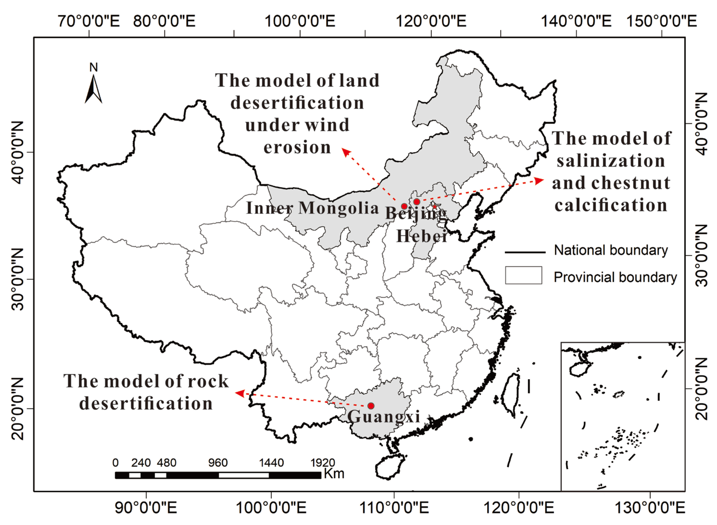
2.1. Study Area and Sampling

The study areas were the sandy area at the north foot of Yinshan Mountain in the Inner Mongolia Autonomous Region of north China, the salinization area at the Bashang Plateau in the Hebei province of north China, and the rocky desertification of the Karst area in Guanxi Province of south China (Figure 1). Within the three ecological problem areas, 23 soil profiles were collected. Digging was employed to prepare the soil profiles. From each horizon, at least one sample was collected: bedrock horizon (R), parent material (half-weathered rock) horizon (C), and two soil horizons (A or B). In total, 83 samples were collected. In each profile, the sampling interval was not kept constant, but rather depended on the thickness of adjacent soil horizons.
(1)
Geography and climate at the northern foot of Yinshan Moutain
The northern foot of Yinshan Mountain is located in the middle of Inner Mongolia, which is a typical farming–pastoral ecotone [16]. It has a semi-arid continental monsoon climate and is upwind of Beijing and north China. The average yearly precipitation is about 300–450 mm, and the annual average evaporation is about 2305 mm, which is 8.14 times higher than the precipitation [17,18]. The dry seasons last for seven months (from October to May of the following year). The annual average wind speed is 3.3–4.6 m/s, and there are 40–80 days in the whole year when the wind speed is higher than wind force 8. The climate in this area is characterized by aridness, low temperatures, and strong wind [19,20]. The main soil type is chestnut soil (Kastanozems), with a low organic matter content. Basalt, granite, metamorphic rock, and sandy gravel sediments are the main parent materials/rocks for weathered soils. Under the combined effect of the above conditions, strong solid desertification occurs in this area, leading to ecological degradation [21,22].
(2)
Geography and climate at Bashang Plateau in Hebei province
The Bashang Plateau, located in Hebei Province, is a typical undulating plateau landform in which the sandy land and gently sloping hills are the main features. This area is a typical farming–pastoral ecotone under a temperate continental climate. The average annual temperature is −0.3–4.7 °C, and the average yearly precipitation is about 382–560 mm [23]. The main soil types are chestnut soil (Kastanozems)and aeolian soil (Arenosols), with pH values of 5.52–7.37. The main soil texture is sandy and loam, presenting thin soil horizons, low organic matter content, loose texture, and poor water/fertilizer retention capacity [24]. The primary lithology of the study area is basalt and granite. The ecosystem type of the study area is temperate steppe, including steppe and wetland meadow steppe. The primary vegetation types are natural grass, artificial grass, and artificial shelter forest [24]. In recent years, excess forest mortality has been observed in Bashang Plateau, and a series of studies have been launched in order to focus on the mechanism of plantation degradation and the influencing factors, such as soil properties, climatic and environmental conditions, and tree physiology [25,26,27]. However, only a limited number of studies have investigated the surface geological process, which determines the ecological evolution to a degree [28]. In this study, the Anggulinao area, a small basin in the intermountain depression from Bashang Plateau, was selected in order to explore the relationship between ecology and geology and assess the impact of the eco-geology conditions on the growth of artificial forests.
(3)
Geography and climate in Karst area of Guangxi province
Guangxi is located at the southeast edge of the Yunnan–Guizhou Plateau, which is in the hilly basin landform [29]. It is in a subtropical monsoon climate zone. The average annual precipitation is 1630 mm, and the average annual sunshine hours are 1540 h [30]. The seasonal distribution of precipitation and sunshine conditions is not uniform, making winter dry and summer hot and humid. The main bedrock types in this area are limestone, dolomite, siliceous rock, and marbled limestone. The soil’s parent material is the weathering material of the above rocks and modern alluvial and lake sediments. The main soil types are mountain yellow soil (Ferralosols), lateritic red soil (Ferralosols), and brown calcareous soil (Gypsisols) [31]. The vegetation types are mainly coniferous forest, broad-leaved forest, and shrub forest. Coniferous forest is distributed in the northwest, while the broad-leaved forest is distributed in the southeast of Guangxi province [32]. A large number of highly soluble elements in this area were derived from carbonate rocks and readily mobilized, with the less insoluble residues being presented. Constant erosion induced by geochemical weathering eventually resulted in rocky desertification in this area. Inappropriate land use and human activities at some sites, such as the over-reclamation of cultivated land, over-use of the land for firewood, and over-grazing, have accelerated rocky desertification.

2.2. Analytical Methods and Quality Control

In this study, chemical element analyses were carried out according to the National Standard Soil Environmental Quality Standards in China (GB 15618-2008). Referring to our previous methods, original rock or soil samples were ground without particle sorting. All samples were air-dried at room temperature and passed through a 20-mesh screen. After sifting, 200 grams of each sample were removed and ground with an agate. The samples were subsequently crushed in sample preparation equipment free of onyx contamination, sieved through a 100-mesh sieve, and kept at 4 °C. They were analyzed by the National Research Center for Geo-analysis (China) with X-ray fluorescence spectrometry (RS-1818, HORNG JAAN) [33]. For quality assurance and quality control (QA/QC), standard reference materials GSS-1 and GSS-4 were obtained from the China National Standard Reference Materials Center and used as part of QA/QC procedures.
Soil types are named according to the China Soil System Classification (1995).
Soil particle size was analyzed with the laser diffraction technique using a Longbench Mastersizer2000 (Malvern Instruments, Malvern, UK). Before testing, the soil samples were air-dried and manually sieved with a 2 mm sieve to remove roots, stones, and debris. In our work, the particle size was divided into seven grades: very coarse sand (1–2 mm), coarse sand (0.5–1 mm), medium sand (0.25–0.5 mm), fine sand (0.1–0.25 mm), very fine sand (0.05–0.1 mm), silt (0.002–0.05 mm), and clay (<0.002 mm).
Soil pH was measured by a pH meter in a 1:2.5 soil-deionized water suspension.
The chemical alteration index (CIA) was calculated using the following formula: CIA = [Al2O3/(Al2O3 + K2O + Na2O + CaO*)] × 100% [34]. It is an important indicator to judge the degree of chemical weathering and is widely used in the study of rock weathering. CaO* is the quantity of CaO in the silicate that must be removed from the carbonate and phosphate. In general, silicate mineral isolation and purification from soils and sediments is difficult. Obtaining silicate minerals from soils and sediments is challenging; thus, we used McLennan’s approach to rectify for CaO [35]. In silicate minerals, the ratio between Na and Ca is proportionate. If the molarity of CaO in soil or sediment samples is less than Na2O, the molarity of CaO can be used to compute CIA; if the molarity of CaO is larger than Na2O, the molarity of Na2O is used instead of CaO.

3. Eco-Geology Model for Land Desertification

The geographical and vegetation characteristics were found to vary significantly from the north to the south of Yinshan Mountain (Figure 2), which may be a result of the difference in weathering resistance between types of bedrock. Correspondingly, three sections were classified: the north section as a gentle-slope hilly landform, with grassland as the primary vegetation type, basalt as the main bedrock type, and chestnut soil (Kastanozems) as the primary soil type; the middle section as a low-mountain hilly landform with shrubs as the primary vegetation type, granite as the bedrock type, and chestnut soil (Kastanozems) and cinnamon soil (Luvisols) as the main soil types; the south section as a medium-altitude mountain landform with the bedrock being micrite, the dominant vegetation being trees, and the main soil types being grey cinnamon soil (Luvisols) and grey forest soil (Haplic Greyzem). An eco-geology model of land desertification under wind erosion was established based on the influence of wind erosion on land desertification and vegetation.

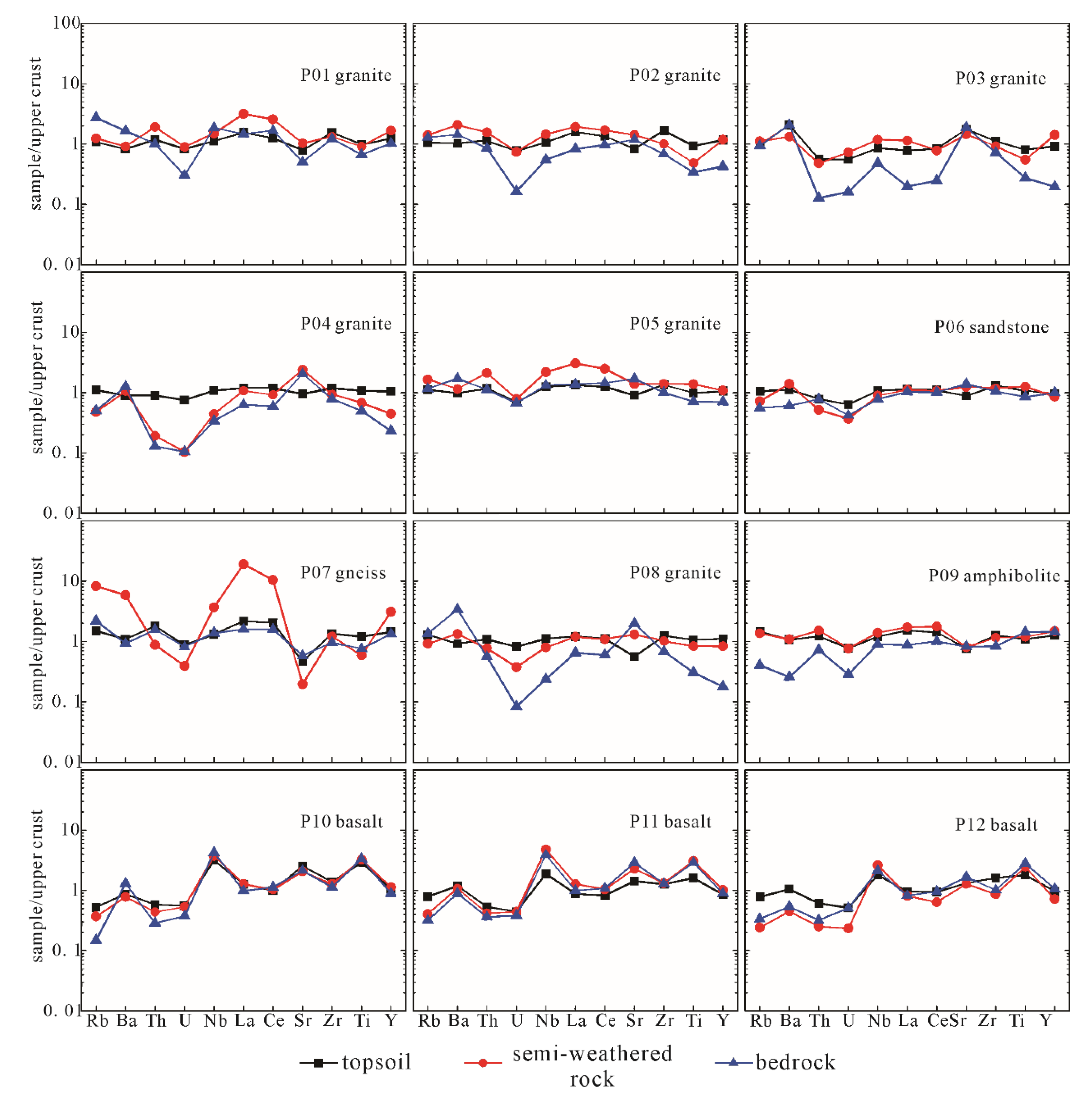
3.1. Distribution of Major Elements within Soil Particles

The migration and redistribution of elements during the weathering of rock into soil can indicate the degree of soil formation and weathering [36,37]. Due to their differing geochemical characteristics, different elements exhibit relative enrichment or leaching loss during soil formation; consequently, the enrichment or leaching characteristics of major elements are frequently used as indicators to measure rock weathering and soil development [38].
The results of the elemental geochemical investigation (Table 1, P10–12) of the northern section revealed that the amount of SiO2 in the soil horizon was much higher than that in the parent rock, indicating the significant immigration of Si. Al2O3 and Fe2O3 concentrations in the soil layer were lower than those in the bedrock, indicating the emigration of Al and Fe. The concentrations of MgO, CaO, Na2O, and K2O all decreased during the weathering process. Due to the high Mg and Ca contents of the basalt parent rock, the decreasing tendency in the soil layer was more pronounced.
The SiO2 content of the middle section was lower than that in the bedrock (Table 1, P01–05). However, the SiO2 content of the P01 and P05 soil layers was greater than that of the semi-weathered horizons, indicating the immigration of Si, which might be related to the wind erosion settlement process. Al2O3 content showed a declining trend from bedrock to soil, indicating that the Al was lost during the weathering process, which might be associated with the wind erosion process. However, the concentration of Fe2O3 in the profile showed a completely different tendency than that of Al2O3, indicating that Fe2O3 was more stable and less influenced by its external environment. Due to the low Mg and Ca concentration of the granite parent rock, a certain degree of enrichment occurred throughout the weathering process. The Na and K, which were present in high contents in granite, showed a normal decreasing trend during weathering.
Due to the diverse bedrocks of the weathering profiles in the south section, the behavior of the same components in the different profiles differed (Table 1, P06–09). During natural weathering, the SiO2 concentration primarily drops, while the Al2O3 and Fe2O3 concentrations primarily increase. However, as compared to the bedrock, the SiO2 content of the sandstone (P06) and amphibolite (P10) profiles rose. Al2O3 concentrations declined in the gneiss (P07) and granite (P07) profiles, while Fe2O3 concentrations decreased in the amphibolite (P10) profile. MgO, CaO, Na2O, and K2O also exhibited divergent trends among profiles. This showed that the location may be less susceptible to wind erosion, with bedrock lithology serving as the primary control over weathering.

3.2. Distribution of Trace Elements within Soil Particles

Throughout weathering, the behavior of stable trace elements in different horizons within the same profile consistently maintained the same trend, independent of element enrichment or deficiency, resulting in a good inheritance of trace elements between distinct strata [39]. However, the migration of foreign weathering products could alter the variation trend of trace elements and disrupt the transmission of elements between horizons [21]. The inheritance and difference between stable trace elements in the soil horizons and semi-weathered horizons of the profile and the bedrock horizons could possibly be utilized to determine the migration of foreign materials in the soil horizons and semi-weathered horizons of the profile.
The trace elements were normalized using the upper continental crust elemental abundance (UCC) values [40], and the results obtained after eliminating the magnitude differences are shown in Figure 3.
Trace elements in the north section of the soil horizons were slightly different from those in the semi-weathered and bedrock horizons, with a small amount of migration of foreign materials being shown. However, the north section (P10–P12) had the best inheritance among the layers compared to the other two sections.
Trace elements of the weathering profiles (P01–P05) from the middle section revealed that the soil horizons had a good inheritance relative to the semi-weathered horizons. Still, both had poor inheritance relative to the bedrock horizons, indicating a significant influence of the external environment on the soil and semi-weathered horizons during the weathering process, with the apparent migration of foreign materials.
Trace elements of the south section weathering profiles (P06–P09) indicated that, except for the D06 profile, the succession of soil and semi-weathered horizons to bedrock horizons in the other three profiles was weak, and the immigrant of foreign materials was evident.

3.3. Distribution of Soil Grain Sizes

The horizon of the rock weathering profile most immediately and severely impacted by wind erosion was the soil horizon. The range of soil grain sizes affected by varying intensities of wind erosion was variable [12], allowing wind erosion to sort soil grain sizes to some degree [41]. Therefore, the characteristic of soil particle size distribution in the soil horizon was the most intuitive indicator of wind erosion severity.
The particle size distribution of the soil horizons in rock weathering profiles is shown in Table 2. The highest concentration of silt (0.002–0.05 mm) accounts for approximately 50 to 70 percent of the total, followed by very fine sand (0.05–0.1 mm), which accounts for about 15 to 35 percent of the total, then fine sand (0.1–0.25 mm) and clay (0.002 mm), which account for approximately 10 and 5 percent of the total, respectively. Coarse-grained material with a particle size greater than 0.25 mm was the least abundant and restricted to a few soil levels in the profile.
Compared to the other two sections, the middle section’s soil horizons contained slightly less clay and silt (less than 0.05 mm) and much more very fine sand. This difference may result from wind erosion, which caused the emigration of clay and silt and the immigration of a small amount of very fine sand. In the soil horizons of the south section, the proportion of silt particles was relatively high. This could be due to the wind erosion resulting in the deposition of finer foreign powder particles due to weaker wind erosion. The presence of slightly more clay grains in the soil horizons of the north section compared to the other two sections was likely due to the basalt parent rock, which was more easily weathered.

3.4. The Effect of Wind Erosion

Rock weathering into soil is a process in which primary rock minerals are continuously weathered and secondary clay minerals are continuously formed [38], resulting in a gradual accumulation of clay mineral content in the soil. However, when soil is subjected to external erosion, the clay minerals in the soil will migrate out under the influence of external forces, and their concentration will decrease.
The results of major elements (Table 1) revealed a clear tendency for Al2O3 to decrease in the north section and middle section profiles. As Al was the most prevalent element in clay minerals, this indicated a significant decrease in clay minerals in the soil horizons of these two sections and the presence of extensive soil erosion. Based on the climatic conditions of Yinshan Mountain, it is possible to conclude that wind erosion is the primary cause of soil erosion in the north and middle sections.
As shown in Table 1, the CIA values of the north section soil horizons were lower than those of the semi-weathered horizon. According to the formula for CIA [35], the decrease in CIA values was typically the result of a decrease in Al and an increase in K, Na, and Ca. However, the K, Na, and Ca were significantly leached out during weathering, so the significant decrease in Al content was the primary cause of the decline in CIA values. This indicates that the north section experienced more intense wind erosion, including severe soil erosion and a large emigration of weathering products such as clay minerals from the soil horizons, as well as a decrease in Al2O3 content and CIA values.
In addition to causing the loss of fine-grained weathering products such as clay minerals in the soil layer, wind erosion also results in the migration of foreign substances. Only when the strength of the wind erosion reduces will the particles carried by the wind settle, leading to immigration, since it is more difficult for particles to settle while the wind erosion is strong. As depicted in Figure 3, the soil and semi-weathered horizons of the middle and south sections were poorly inherited relative to the bedrock horizons, and the immigration of foreign material was evident. This suggests that wind erosion in the middle and south sections was diminished. The succession between horizons in the north section was good, with almost no immigration of foreign material, and only the soil horizons displayed a moderate fluctuation, with a tiny degree of immigration of foreign material, indicating that the area is subject to intense wind erosion.
In conclusion, the north section was most affected by wind erosion, with a substantial quantity of weathering products migrating out, a major drop of CIA in the soil horizon, and a small quantity of foreign materials migrating in. The middle section was less affected by wind erosion, with a significant reduction in clay minerals seen in the soil layer and a large amount of foreign materials migrating in. The southern part was the least affected by wind erosion, with virtually no weathering products flowing out but a noticeable influx of foreign materials.

3.5. Model Mechanism

The terrain at the northern foot of the Yinshan Mountains is elevated in the south and low in the north, with a stepped spatial distribution of undulating plains, gently sloping hills, low hills, and mountains from north to south. As the wind passes through these locations, the wind erosion weakens as the terrain rises and the topography becomes more complex, and the materials carried by the wind sink in tandem with the wind erosion’s weakening (Figure 2).
The undulating plateau region is a transitional location where the northern foot of the Yinshan Mountains meets the Inner Mongolia Plateau. It has an average altitude of approximately 1300 m, sparse vegetation, and strong winds, making it an important source of wind and sand in the research area.
The gently sloping hilly region corresponds to the north section of the research area, which is relatively flat and open, has an average elevation of approximately 1550 m, and is susceptible to wind erosion. The rocks here were affected by wind erosion, with a small amount of coarse-grained material migrating in. A large amount of fine-grained material migrated out, which increased the content of SiO2 and significantly decreased the content of Al2O3 in the soil. The CIA value of the soil horizons was lower than that of the semi-weathered horizons, resulting in a reduction in the thickness of the soil horizons in the profiles (not more than 20 cm), nutrient loss, and increased sanding. Therefore, this section’s predominant type of vegetation is grass, which grows sparingly and is small.
The low-mountain hilly area corresponds to the middle section, with a diverse topography and an average altitude of approximately 1650 m. The rocks here are less susceptible to wind erosion, and fine-grained material dominates the interchange of material. The rocks were less impacted by wind erosion, and fine-grained material interchange dominated the material exchange. This caused a minor drop in the clay and powder content of the soil horizons, a decrease in Al2O3, and an increase in the concentration of extremely fine sand. Trace element behavior in the soil and semi-weathered horizons differed slightly from that in the bedrock horizons. However, the CIA values were still higher in the soil horizons than in the semi-weathered horizons. Consequently, there was a small loss of nutrients, while the soil layer remained practically the same thickness (20–40 cm). This section was dominated by grass, but its growth was denser than in the north section, and there was a minor amount of small shrub development.
The medium-altitude mountain area corresponds to the south section, with the highest altitude (1800 m) and a predominantly mountainous terrain. The rocks were least affected by wind erosion, and the deposition of fine-grained material dominated material exchange, leading to a rise in the fine-grained content of the soil layer and an increase in the Al2O3 content. Trace element behavior in the soil and semi-weathered horizons differed significantly from in the bedrock horizons, but the sequence of weathering horizons in the profile was unaffected. The CIA values in the soil horizons were greater than those in the semi-weathered horizons, and the thickness of the soil horizons remained the same or grew slightly (25–40 cm), as there was almost no movement of weathering products. The section’s vegetation was characterized by grasses and tiny shrubs, with extensive and dense plantations of shrubs and pine forests on the slopes.

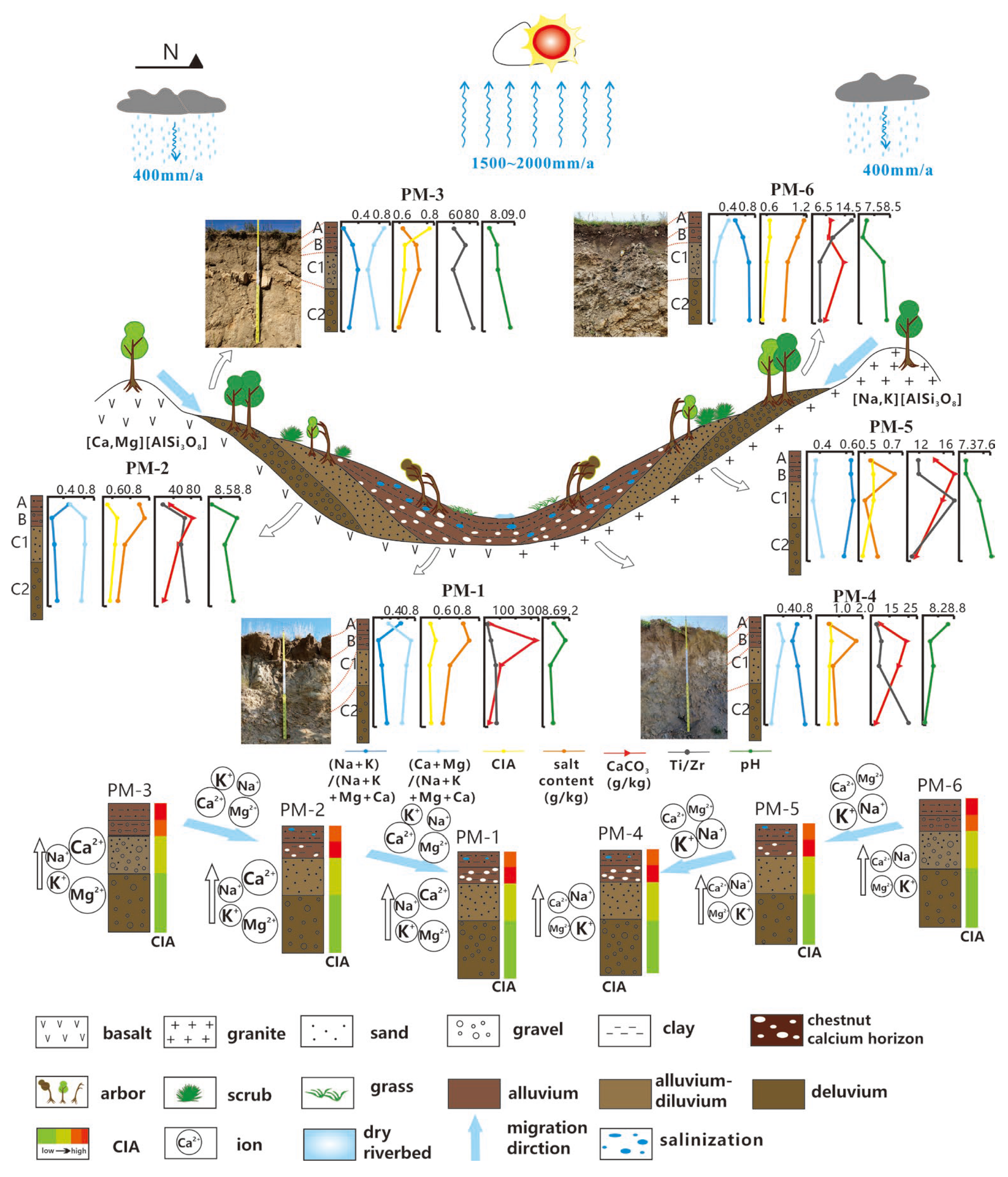
4. Eco-Geology Model for Salinization and Chestnut Calcification

Based on high-resolution remote sensing (~5 m) performed in 2010 and 2018, the recent variations in artificial forest areas from the Bashang Plateau were quantified. The cumulative artificial forest loss area was 47 km2, and this area was mainly distributed in the depression basin and the front of pluvial fans, such as in the Anggulinao intermountain depression [25]. In the area of Anggulinao, the pH values and salt contents of the topsoil were in the ranges of 8.5–9.2 and 1.1–1.2 g/kg, respectively. The calcic horizon occurred at shallower depths (less than one meter from the surface), which prevented root penetration. In fact, the poplar roots in this area could not penetrate through the calcic horizons, which possibly induced the deaths or caused considerable reductions in the canopy volume of the poplar. In this study, soil profile samples (PM 1–6) were taken from the highlands, hillside areas, and depression center (Figure 4). The physicochemical properties of soil were determined, and geochemical analyses were carried out in order to understand the geological factors affecting the degradation of artificial forests and help establish the eco-geology model.

4.1. Source of Salts

The lithology of the Angulinao depression was basalt in the south and granite in the north. As shown by the geochemical characteristics in the soil-forming profile (Table 3), a large amount of Ca and Mg and a small amount of K and Na were leached during the basalt weathering in the southern mountain area. Meanwhile, a large amount of K and Na and a small amount of Ca and Mg were leached during granite weathering in the northern mountain area. Since the pluvial fans were formed through the weathering and denudation of bedrocks, the composition of soil profiles (PM-1 and PM-4) close to the front of the pluvial fan had similar characteristics to its corresponding denuded bedrocks (basalt in the south or granite in the north). The weathering and denudation of the parent rocks provide a rich source of material for the area’s process of salinization.

4.2. Formation of Calcic Horizon

Pluvial fans formed after the weathering and denudation of bedrock, and a soil horizon (soil horizon B) with white calcium carbonate deposits, commonly referred to as a calcic horizon, was observed at the leading edge (or tail end) of pluvial fans near depression basins (Figure 3). The material generated by the erosion of bedrock in the mountains was continuously moved by gravity into the depression basin due to the topographic difference in height. As a result, the soil near the leading edge of the pluvial fan was much more fine-grained, with a predominantly chalky sand and clay composition and a potent water retention capacity. Under heavy rainfall, Ca, Mg, K, and Na weathered from bedrocks were dissolved in water and migrated laterally along the mountain slope. Due to the strong water storage capacity of the material at the leading edge of the pluvial fan and its tendency to level the terrain, the concentration of alkaline ions dissolved in water changes when there is less precipitation or more evaporation. At the leading edge of the alluvial floodplain, salt-alkaline ions ultimately replenished the soil layer.
According to Table 3, the alkali ion enrichment coefficients in depression basin horizon B (PM-1 and PM-4) were 1.3–3.2 times greater than those in horizon D, showing a salinization trend in the depression basin. The CIA of horizon A was lower than that of horizon B, while the salinity level of horizon B was significantly higher than that of horizon A. The results indicated that the rainfall-induced downward infiltration of fine particles and alkaline ions leads to the enrichment of clay and salts in the B horizon. This revealed that, in addition to bedrock weathering, the infiltration of surface material created by rainfall leaching contributed to the enrichment of salt in horizon B. Ca and Mg ions were enriched in horizon B and susceptible to forming calcic horizons, as indicated by the profile parameters.

4.3. Model Mechanism

In the center of the depression basin (PM-1 and PM-4), capillary action and rapid evaporation enriched layer A with alkali ions dissolved in soil water (Table 3). This salting-out process occurred in the depressions, where the pH levels (8 to 9) were significantly higher than the region’s average (5.52–7.37). Simultaneously, in the deep soil of the depression basin and pluvial fan, the calcic horizon was produced. In conclusion, it is difficult for plants to grow in the center of a depression basin with strongly alkaline soil, and the presence of a calcic horizon inhibits root development. As a result, poplar trees were planted artificially but were unable to survive.
In the hillside region, distant from the depression basin, the diluvial deposits consisted primarily of silt and sand. The particle size here was much coarser than that of the depression basin, resulting in inadequate water retention. The analysis of geochemical elements revealed that the CIA of horizon A was less than that of horizon B. Additionally, the salt content of layer B was greater than that of horizon A (Table 3, PM-2 and PM-5), indicating that the downward infiltration of fine surficial particles generated by precipitation led to the enrichment of Ca and Mg in horizon B. However, the enrichment degree of calcium carbonate and salt in this region was considerably less than that of soils in front of the pluvial fan (Table 3, PM-1 and PM-4). Therefore, bushes and poplar trees may thrive on the hillside.
In the mountaintop region, the soil consisted primarily of eluvium materials with coarse particles and insufficient water storage capacity. From bedrock to topsoil, elemental geochemistry studies (PM-3 and PM-6) revealed an average upward trend of CIA (Table 3). In this region, alkaline ions in the soil were transferred primarily laterally, with little vertical migration, and no calcium carbonate or alkaline ion deposit layer was evident. Thus, the elements Ca, Mg, K, and Na leached from worn bedrock were not easily concentrated, and the calcic horizon could not form. Thus, the mountaintop favored poplar growth (Figure 4).
The model of soil calcification in the alluvial-diluvial basin demonstrated the dominant contribution of bedrock and its weathering process to the high-alkali and high-salt background (Figure 4), which resulted in forest degradation. In the arid environment of the Bashang Plateau, surface geological characteristics such as bedrock type, topography, geomorphology, and geochemical processes influenced soil salinization. K and Na were primarily leached from the weathering of granite, while Mg and Ca were extensively leached from the weathering of basalt. In the catchment areas of the depression basin and the front of the pluvial fan, soluble alkali ions were concentrated in soils and ultimately precipitated calcium carbonate depositions in layer B or were salted to the surface. Due to the high salinity and calcareous strata near the front of the pluvial fan and in the middle basin, tree development was impeded.

5. Eco-Geology Model for Rocky Desertification

According to the coverage of rocks and vegetation, the level of rocky desertification was tentatively divided into mild, middle, middle-severe, and severe degrees (Figure 5). Mild rocky desertification was characterized by a thick soil layer and high vegetation coverage, mainly consisting of arbors and shrubs. Middle rocky desertification was characterized by a thin soil layer and high vegetation coverage, especially shrubs and grasses. Middle to severe rocky desertification was characterized by a thin soil layer and low grass coverage. Severe rocky desertification was characterized by the presence of large bare rocks and low vegetation coverage. Based on the characteristics of bedrock, five soil profiles (PMQBN01, PMWM01, PMQBN03, PMBM01, and PMTD03) were, respectively, sampled in order to explore the four grades of rocky desertification (Figure 5).

5.1. Soil-Forming Parent Material

Guangxi’s carbonate rocks are strong and dense, with high levels of soluble components. They are resistant to weathering and scouring, and their primary mode of erosion is dissolution. As carbonate rocks are predominantly formed of calcium and magnesium carbonate, the soluble minerals are rapidly removed by water through dissolving, and there are few insoluble leftovers, resulting in exceedingly poor soil formation conditions. Only 30 cm of weathered limestone can produce 1 cm of soil, or, in other words, the ratio of soil formation to dissolution is 1/30 [42].
Guangxi has a temperate climate with copious precipitation and moderate dissolution. The Karst rate of carbonate rocks was around 0.12–0.3 mm/a, corresponding to 120–300 m3/km2/a or 312–780 t/km2/a, assuming a rock-specific gravity of 2.6 t/m3. Calculating the rate of soil formation in the carbonate region of Guangxi yielded a range of 10.4–26.0 t/km2/a. Taking into consideration other factors that accelerate weathering, it is roughly assumed that the rate of soil formation in carbonates was not greater than 50 t/km2/a [42,43]. Consequently, the pace of soil formation in Karst regions was typically lower than the rate of erosion, creating favorable conditions for the development of stone desertification. According to the available data, most of the rock desertification in western China occurred in carbonate rock regions, confirming the close relationship existing between rock desertification and the parent rock of soil formation [43].
Table 4 revealed that, with the exception of CaO, the mass fractions of all macronutrients were lower in the bedrock horizons (R) than in the topsoil horizons (A) and sedimentary horizons (B). This indicated that the tuffs underwent varying degrees of weathering and leaching during the formation of soil, with CaO being heavily leached and other elements being enriched to varying degrees, which was consistent with the evolution of elements in the weathering crust of carbonate rocks in general. In all profiles, the La/Sm ratios of soil and bedrock were comparable, indicating that no additional material was added to the bedrock during the weathering process and that the soil was the result of in situ weathering. This suggests that carbonate weathering is the ultimate source of material for the soils in the study area.
The soil’s clay is rich in silica and aluminum, and the higher the Al2O3 content is, the greater the CIA index and degree of chemical weathering will be. This study expresses soil particle size as clay/(powder + sand) values; the greater the ratio is, the stronger the weathering will be. With the exception of a few profiles (PMWM01), the properties of the soil profiles (Table 4) reveal a regular variation in the overall profile, from light and moderate to heavily rock-deserted areas, where the clay/(powder + sand) values and the CIA index increase gradually, and the degree of chemical weathering of the soil increases. The high clay/(powder + sand) and CIA values in the moderate rock-deserted region (PMWM01) are likely attributable to the accumulation of clay in the soil.

5.2. Degree of Soil Weathering

The soil’s clay was rich in Si and Al, and the higher the Al2O3 content was, the greater the CIA index and degree of chemical weathering were. This study expressed soil particle size as clay/(silt + sand) values, where the greater the ratio was, the stronger the weathering was. With the exception of a few profiles (PMWM01), the properties of the soil profiles (Table 4) revealed a regular variation in the overall profile, from light and moderate to heavily rock-deserted areas, where the clay/(silt + sand) values and the CIA index increased gradually, and the degree of chemical weathering of the soil increased. The high clay/(powder + sand) and CIA values in the moderate rock-deserted region (PMWM01) were likely attributable to the accumulation of clay in the soil.

5.3. Model Mechanism

During the chemical weathering, major elements such as Ca and Mg were highly active and easily converted into soluble ions, while the stable Si and Al formed the main components of soils [12,44]. Therefore, the ratio of soluble elements (Ca + Mg) to stable elements (Al + Si) was utilized to describe the pedogenic potential of parent materials (Table 4). The ecological–geological model of the Guangxi rock-deserted region was established by combining the ratio with the surface vegetation features.
The soil PMQBN01 was sampled from a mild rocky desertification area, in which the parent materials were siliceous rocks interbedded with limestone. As shown in Table 4, the value of 0.12 obtained for (Ca + Mg)/(Al + Si) in siliceous rock (PMQBN01-7R) showed its high content of insoluble elements. In contrast, the value of 4.75 obtained for (Ca + Mg)/(Al + Si) in limestone (PMQBN01-6R) indicated its low content of insoluble elements. The above results suggest the great difference in weathering resistance between siliceous rocks and limestone. In this area, the difference in the weathering resistance of bedrock may cause a gentle slope in the region’s geography, in which the weathering residues, including soils, remained. As a result, the soil layer was relatively thick in this area. Since rainfall was abundant in Guangxi, trees and other vegetation grew well.
PMWM01 was the soil profile from the middle rocky desertification area, and its parent rock was limestone. The ratio of (Ca + Mg)/(Al + Si) was 4.4 (Table 4), indicating low contents of insoluble components and a relatively weak pedogenic capacity. Differential dissolution occurring in limestones created landforms of a multi-peak mountain with depressions [43]. Due to the steep topography of the peak mountain, the weathering residues formed by bedrocks could not be retained in situ and tended to migrate to depression areas. Therefore, the soil layer in the peak mountain area was thin and could not support the growth of tall trees but was sufficient for shrubs and grasses.
PMQBN03 was the soil profile from the middle rocky desertification area, and its parent rock was marbled dolomite. The ratio of (Ca + Mg)/(Al + Si) of 4.57 suggested a low concentration of insoluble components and a limited pedogenic potential. In addition, the recrystallization of dolomite increased its resistance to weathering and slowed its rate of dissolution. As a result, the soil layer that formed in this location was too thin to sustain the growth of towering trees but was adequate for shrubs and grasses. PMBM01 was the soil profile from the middle-severe rocky desertification area, and its parent rock was pure limestone. The (Ca + Mg)/(Al + Si) ratio was 4.79, indicating low contents of insoluble components and a weak pedogenic capacity. Therefore, the soil layer formed in this area was thinner than the profiles mentioned above, and the vegetation was mainly sparse grass with small-scale bare rocks.
PMTD03 was the soil profile in the severe rocky desertification area, and its parent rock was the huge and thick marble limestone with obvious marbling. The value of 4.92 obtained for (Ca + Mg)/(Al + Si) indicated the further lower contents of insoluble components. Since the marble limestone in this area was recrystallized and extremely thick, its weather resistance was stronger than that of the other carbonate rocks mentioned above. Therefore, the soil layer in this area was extremely thin. Nevertheless, the weathering residues from parent rocks could remain in trenches or pits, which also received the soil materials derived from other sites at higher elevations. Thus, the soil layer in the low-lying areas was relatively thick, and in these places grass grew sparsely. In contrast, herbaceous vegetation could not survive on the steep slopes among the rock debris.
In the soil profiles collected from areas with different degrees of rocky desertification, the contents of total N, total P, total K, and the main nutrient elements responsible for plant growth did not show significant differences (Table 5).
Based on the explanation given above, the eco-geology interaction model was created (Figure 4). In conclusion, rocky desertification and vegetation in the Guangxi Karst region exhibited a strong association with the lithology and terrain slope of the parent rocks. Within areas of undulating terrain, moderate and severe rocky desertification occurred frequently, and the bedrocks in these areas were limestone, dolomite, and marble limestone. Therefore, the soil here was thin, the vegetation cover was low, and shrubs and grass were the predominant species. In contrast, the soil layer was considerably thicker in areas of mild rocky desertification, where the underlying rocks were interbedded limestone, mudstone, sandstone, and argillaceous limestone. Due to the differing rates of weathering seen among these rocks, the ground in these areas was also quite flat. Thus, the plant cover also increased.

6. Conclusions

For both human life and the environment of the Earth, ecological characteristics are crucial. The processes that create soil have an impact on, and are even dependent upon, an area’s natural features. The influence of soil-forming processes on vegetation distribution and ecological issues can be revealed by analyzing the weathering and soil-forming processes of bedrock, visualizing their ecological impact, and developing ecological models.
The land desertification that occurred at the north foot of Yinshan Mountain resulted from bedrock weathering by wind erosion under a semi-arid continental monsoon climate. Clay and silt were transported by wind within the Inner Mongolia Plateau and then deposited in a slightly higher area. Therefore, the soil layer here was thicker and the content of clay mineral in the soil was increased in the higher-altitude area. As a result, arbor trees became the main vegetation type in medium-mountain landforms, shrubs were the main type in low-mountain hilly landforms, and grass was the main type in gentle-slope hilly landforms.
The soil salinization and calcic horizon at the Bashang Plateau were the result of fine particles and alkali ions migrating from the mountaintop to the center of the intermountain depression. Under the semi-arid continental monsoon climate, the alkali ions were concentrated in the depression’s center. Simultaneously, the vertical leaching caused Ca ion enrichment in the B layer and the formation of a calcic horizon. Therefore, it was hard for trees to grow at the front of the pluvial fan and in the center basin.
The degree of rocky desertification in the Karst region was tentatively divided into four types according to the rock outcrops and vegetation present. Rocky desertification was mainly controlled by the soil parent materials/rocks, even though some sites were exposed to the real danger of human-made deconstruction. Within undulating terrain, moderate and severe rocky desertification occurred frequently, with limestone, dolomite, and marble limestone serving as the main source rocks. As a result, the soil in these areas was thin, the plant cover was minimal, and shrubs and grass were the major species present. In contrast, the soil layer was significantly thicker in areas of mild rocky desertification, where interbedded limestone, mudstone, sandstone, and argillaceous limestone comprised the underlying rocks. As a result of the varying rates of weathering among these rocks, the ground in these areas was also rather level. Consequently, the plant cover grew.

Author Contributions

Conceptualization, X.-Y.G., J.L. and G.-L.Y.; methodology, X.-Y.G.; validation, X.-Y.G., J.L. and Y.-H.J.; formal analysis, X.-Y.G.; investigation, X.-Y.G. and J.-L.Z.; resources, X.-Y.G.; writing—original draft preparation, X.-Y.G.; writing—review and editing, J.L. and G.-L.Y.; visualization, Y.-H.J.; supervision, G.-L.Y.; project administration and funding acquisition, G.-L.Y., J.-L.Z. and Z.-J.L. All authors have read and agreed to the published version of the manuscript.

Funding

This research was supported by the projects of the China Geology Survey (DD20190536, DD20208069).

Institutional Review Board Statement

Not applicable.

Informed Consent Statement

Not applicable.

Data Availability Statement

Not applicable.

Acknowledgments

This work was supported by the projects of the China Geology Survey (DD20190536, DD20208069). We offer our sincere thanks to Hongfeng Nie, Xiao Chunlei, and Liu Jianyu of the China Aero Geophysical Survey and the Remote Sensing Center for Natural Resources for their enthusiastic support of this work.

Conflicts of Interest

The authors declare no conflict of interest.

References

  1. Zhao, Y.; Gong, J.; Wang, H. Eco-environmental geochemistry of Hebei province. Geophys. Geochem. Explor. 2004, 28, 270–272. [Google Scholar]
  2. Nie, H.F.; Xiao, C.L.; Ren, W.X.; Liu, J.Y.; Dai, M. Progress and prospect of ecogeological research. Geol. Surv. China 2021, 8, 1–8. [Google Scholar] [CrossRef]
  3. Luo, Z.P.; Xiong, K.N.; Xu, L.X. Study on the Role of Biological Soil Crust in Ecological Restoration and Its Enlightenment to the Control of Rocky Desertification. Res. Soil Water Conserv. 2020, 27, 394–404. [Google Scholar]
  4. Labianca, C.; De Gisi, S.; Todaro, F.; Notarnicola, M.; Bortone, I. A review of the in-situ capping amendments and modeling approaches for the remediation of contaminated marine sediments. Sci. Total Environ. 2022, 806, 151257. [Google Scholar] [CrossRef] [PubMed]
  5. Meki, K.; Liu, Q.; Wu, S.; Yuan, Y.F. Plant and microbe-assisted biochar amendment technology for petroleum hydrocarbon remediation in saline-sodic soils: A review. Pedosphere 2022, 32, 211–221. [Google Scholar] [CrossRef]
  6. Ding, W.N.; Ree, R.H.; Spicer, R.A.; Xing, Y.W. Ancient orogenic and monsoon-driven assembly of the world’s richest temperate alpine flora. Science 2020, 369, 578–581. [Google Scholar] [CrossRef]
  7. Hulshof, C.M.; Spasojevic, M.J. The edaphic control of plant diversity. Glob. Ecol. Biogeogr. 2020, 29, 1634–1650. [Google Scholar] [CrossRef]
  8. Trofimov, V.T. Ecological geology: A novel branch of geological sciences. Earth Sci. Front. 2001, 8, 27–35. [Google Scholar]
  9. Banwart, S.A.; Bernasconi, S.M.; Blum, W.E.H.; de Souza, D.M.; Chabaux, F.; Duffy, C.; Kercheva, M.; Krám, P.; Lair, G.J.; Lundin, L.; et al. Chapter One—Soil Functions in Earth’s Critical Zone: Key Results and Conclusions. In Advances in Agronomy; Quantifying and Managing Soil Functions in Earth’s Critical Zone; Banwart, S.A., Sparks, D.L., Eds.; Academic Press: Cambridge, MA, USA, 2017; Volume 142, pp. 1–27. [Google Scholar]
  10. Rahbek, C.; Borregaard, M.K.; Antonelli, A.; Colwell, R.K.; Holt, B.G.; Nogues-Bravo, D.; Rasmussen, C.M.O.; Richardson, K.; Rosing, M.T.; Whittaker, R.J.; et al. Building mountain biodiversity: Geological and evolutionary processes. Science 2019, 365, 1114–1119. [Google Scholar] [CrossRef]
  11. Yang, J.X.; Liu, C.Q.; Zhao, Z.Q.; Ding, H.; Liu, T.Z.; Long, T.C.; Ling, F.B.; Lu, H. Geochemical Behavior of Rare-Earth Element During the Weathering of Granite under Different Climatic Conditions. Acta Mineral Sin. 2016, 36, 125–137. [Google Scholar]
  12. Zhang, L.K.; Ji, H.B.; Liu, X.M.; Wei, X.; Luo, G.; Shijie, W.; Trung, N.D.; Dinh, N.Q. Genetic mechanism and elemental evolution of weathering laterite crust overlying carbonate rocks in tropical areas. Geol. China 2021, 48, 651–660. [Google Scholar]
  13. Trofimov, V.T. The ecological-geological system, its types and position in the structure of an ecosystem. Mosc. Univ. Geol. Bull. 2009, 64, 111–115. [Google Scholar] [CrossRef]
  14. Richter, D.d.B.; Billings, S.A. “One physical system”: Tansley’s ecosystem as Earth’s critical zone. New Phytol. 2015, 206, 900–912. [Google Scholar] [CrossRef]
  15. Zhu, Y.G.; Gillings, M.; Simonet, P.; Stekel, D.; Banwart, S.; Penuelas, J. Human dissemination of genes and microorganisms in Earth’s Critical Zone. Glob. Change Biol. 2018, 24, 1488–1499. [Google Scholar] [CrossRef]
  16. Li, Z.M.; Li, L.H.; Wang, Y.; Wang, M.; Liu, W.; Nie, Q. Spatial Change of the Farming–Pastoral Ecotone in Northern China from 1985 to 2021. Land 2022, 11, 2179. [Google Scholar] [CrossRef]
  17. Wuyun, D.; Sun, L.; Chen, Z.X.; Hou, A.H.; Crusiol, L.G.T.; Yu, L.; Chen, R.; Sun, Z. The spatiotemporal change of cropland and its impact on vegetation dynamics in the farming-pastoral ecotone of northern China. Sci. Total Environ. 2022, 805, 150286. [Google Scholar] [CrossRef]
  18. Miao, H.L.; Wang, A.T.; Zhang, R.Q.; Li, J.R.; Gao, T.M. Characteristics of wind regime and drift potential of the desert steppe in northern slope of Yinshan Mountains, Inner Mongolia. J. Arid Land Resour. Environ. 2022, 36, 102–110. [Google Scholar]
  19. Li, X.; Shen, X.D.; Zhang, Y.J. Experimental analysis on soil wind-erosion amount in Siziwang Banner North Yinshan Mountain, Inner Mongolia. Arid Land Geogr. 2006, 29, 292–296. [Google Scholar]
  20. Feng, S.; Lan, D.M.; Zhao, H.S.; Zhao, X.H.; Guo, L. Floristic analysis of woody plants in the northern foot of Yinshan Mountain. Arid Zone Res. 2021, 38, 241–246. [Google Scholar]
  21. Chen, Z.X.; Yu, E.F.; Shi, S.B.; Mao, Y.F. Strategies for Rejuvenation of Degenerated Natural Grassland Within Northern Agro-grazing Ecotone of Yinshan Mountains, Inner Mongolia. Res. Soil Water Conserv. 2002, 9, 41–45. [Google Scholar]
  22. Zhao, J.; Tuo, D.B.; Zhao, P.Y. Strategy of Optimum Land Utilization Structure to Prevent Wind Erosion and Desertification in North Foot of Yinshan Mountain. Inn. Mong. Agric. Sci. Technol. 2003, 5, 1–3+9. [Google Scholar]
  23. Zheng, C.Y.; Xu, Z.Q.; Ma, C.M.; Di, K.; Cheng, Y.M.; Sun, S.J.; Yan, T.F. Soil Properties of Degraded Shelter Forests in Bashang Plateau of Northwestern Hebei Province. J. Soil Water Conserv. 2016, 30, 203–207. [Google Scholar]
  24. Zheng, C.Y.; Xu, Z.Q.; Ma, C.M.; Sun, S.J.; Yan, T.F. The Factors Influencing the Poplar Shelterbelt Degradation in the Bashang Plateau of Northwest Hebei Province. For. Resour. Manag. 2018, 1, 9–15+147. [Google Scholar]
  25. Li, Y.X.; Zhang, Z.D.; Zhao, W.S.; Cai, H.Y. In Situ Measurement Based Study on Spatial Variability of Soil Salinity at Small Scale in Bashang Region of Hebei Province. Geogr. Geo-Inf. Sci. 2014, 30, 99–103. [Google Scholar]
  26. D’Avello, T.P.; Waltman, W.J.; Waltman, S.W.; Thompson, J.A.; Brennan, J. Revisiting the Pedocal/Pedalfer boundary and Soil Moisture Regimes using the javaNewhall simulation model and PRISM data. Geoderma 2019, 353, 125–132. [Google Scholar] [CrossRef]
  27. Wu, Z.Y.; Zhang, C.; Jiang, Z.C.; Luo, W.Q.; Xiao, Q.; Hu, Z.X.; Wu, H.Y. Subsoil carbonate dissolution rates and their determining factors in a karst drainage basin, SW China. Environ. Earth Sci. 2020, 79, 508. [Google Scholar] [CrossRef]
  28. Zhang, H.; Cao, J.; Wang, H.B.; Song, B.; Jia, G.D.; Liu, Z.Q.; Yu, X.X.; Zeng, J. Water utilization characteristics of the degraded poplar shelterbelts in Zhangbei, Hebei, China. Ying Yong Sheng Tai Xue Bao, J. Appl. Ecol. 2018, 29, 1381–1388. [Google Scholar] [CrossRef]
  29. Wu, J.; Liang, Q.; Tong, X.H. Study on the influence of topographic factors on the distribution and yield of rice in Guangxi. J. Shaanxi Univ. Technol. Sci. Ed. 2020, 36, 85–92. [Google Scholar]
  30. Li, Y.J.; Lu, J.; Li, Y.L.; He, J.L.; Huang, X.S.; Huang, Z.; Zhuo, M.L. Climate survey of Guangxi in 2020. J. Meteorol. Res. Appl. 2021, 42, 100–104. [Google Scholar]
  31. Liu, Y.X.; Xiong, L.M.; Wei, C.H.; Tan, H.; Yang, S.; Nong, M.L.; Zeng, Y.; Huang, G.Q.; Zhao, Q.G. Changes of soil fertility and its comprehensive evaluation under different stands in typical types of soils in Guangxi Province. Acta Ecol. Sin. 2014, 34, 5229–5233. [Google Scholar]
  32. Liao, C.G.; Xiong, X.J.; Hu, B.Q.; Chen, Y.L.; Chen, Y.L.; He, T.X. Variation of Vegetation Cover on Various Lithology and Its Response to Human Activities in Guangxi. Ecol. Econ. 2018, 34, 168–173. [Google Scholar]
  33. Wang, A.T.; Wang, Q.; Li, J.; Yuan, G.L.; Albanese, S.; Petrik, A. Geo-statistical and multivariate analyses of potentially toxic elements’ distribution in the soil of Hainan Island (China): A comparison between the topsoil and subsoil at a regional scale. J. Geochem. Explor. 2019, 197, 48–59. [Google Scholar] [CrossRef]
  34. Nesbitt, H.; Young, G. Early proterozoic climates and plate motions inferred from major element chemistry of lutites. Nature 1982, 299, 715–717. [Google Scholar] [CrossRef]
  35. McLennan, S.M. Weathering and Global Denudation. J. Geol. 1993, 101, 295–303. [Google Scholar] [CrossRef]
  36. Braun, J.J.; Pagel, M.; Herbilln, A.; Rosin, C. Mobilization and redistribution of REEs and thorium in a syenitic lateritic profile: A mass balance study. Geochim. Cosmochim. Acta 1993, 57, 4419–4434. [Google Scholar] [CrossRef]
  37. Zhu, L.D.; Zhou, S.Z.; Li, F.Q.; Ye, W.; Cui, Q. The elemental transport features of red earth from TX-Section and its Paleo-climatic implications. Mar. Geol. Quat. Geol. 2007, 27, 117–123. [Google Scholar]
  38. Gong, Z.T.; Huang, C.M. Quantitatives studies on development of tropical soils: A case study in northern Hainan Island. First Earth Sci. 2001, 26, 315–321. [Google Scholar]
  39. Tao, S.; Cao, J.; Li, B.G.; Xu, F.L.; Chen, W.Y. Distribution pattern of trace elements in soil from Shenzhen area. Acta Pedol. Sin. 2001, 38, 248–255. [Google Scholar]
  40. Taylor, S.R.; McLennan, S.M. The geochemical evolution of the continental crust. Rev. Geophys. 1995, 33, 241–265. [Google Scholar] [CrossRef]
  41. Chepil, W.S. Dynamics of wind erosion: I. Nature of movement of soil by wind. Soil Sci. 1945, 60, 305. [Google Scholar] [CrossRef]
  42. Wang, S.J.; Ji, H.B.; Ouyang, Z.Y.; Zhou, D.Q.; Zhen, L.P.; Li, T.Y. Preliminary study on weathering and pedogenesis of carbonate rock. Sci. China Ser. Earth Sci. 1999, 42, 572–581. [Google Scholar] [CrossRef]
  43. Sun, C.X.; Wang, S.J.; Zhou, D.Q.; Li, R.L.; Li, Y.L. Differential weathering and pedogenetic characterisitics of carbinate rocksand their effect on the development of rock desertification in karst regions. Acta Mineral Sin. 2002, 22, 308–314. [Google Scholar]
  44. Cao, J.H.; Yuan, D.X.; Pan, G.X. Some soil features in karst ecosystem. Adv. Earth Sci. 2003, 18, 37–44. [Google Scholar]
Figure 1. The location of three typical ecological problems in China.
Sustainability 15 01002 g001
Figure 2. The eco-geology model of land desertification under wind erosion at the north foot of Yinshan Mountain, Inner Mongolia.
Sustainability 15 01002 g002
Figure 3. The spider web of some stable elements standardized by upper crust in soil profile at the north foot of Yinshan Mountain, Inner Mongolia.
Sustainability 15 01002 g003
Figure 4. The eco-geology model of soil salinization and chestnut calcification at Bashang Plateau in Hebei province.
Sustainability 15 01002 g004
Figure 5. The eco-geology model of rock desertification in the Karst area of Guangxi province.
Sustainability 15 01002 g005
Table 1. Content of major elements in weathering profile at the northern foot of Yinshan Mountain.
ProfileLithologyLayerSiO2
%
Al2O3
%
Fe2O3
%
MgO
%
CaO
%
Na2O
%
K2O
%
CIA
%
Low-mountain hilly landform
P01granitesoil layer60.010.95.132.234.652.202.1653.4
semi-weathered layer55.611.04.411.928.372.242.5851.9
bedrock67.613.62.120.740.613.465.95-
P02granitesoil layer61.111.54.301.783.272.252.4853.4
semi-weathered layer62.012.52.430.886.072.743.7848.8
bedrock70.413.21.500.751.583.904.00-
P03granitesoil layer60.313.24.362.692.863.383.0748.3
semi-weathered layer69.910.13.993.414.622.725.1640.9
bedrock67.314.41.580.330.735.145.47-
P04granitesoil layer57.413.15.622.172.602.252.1357.5
semi-weathered layer58.914.74.461.933.893.781.8850.4
bedrock64.315.12.871.622.874.952.11-
P05granitesoil layer59.913.44.981.842.092.622.6354.9
semi-weathered layer55.314.17.272.032.963.773.0748.7
bedrock63.513.73.821.723.004.254.04-
Medium-altitude mountain
P06sandstonesoil layer60.812.85.502.341.712.702.4155.8
semi-weathered layer55.812.96.312.791.723.122.1754.8
bedrock50.911.23.692.4211.83.431.71-
P07gneisssoil layer57.413.56.732.571.731.472.6163.7
semi-weathered layer47.99.43.666.102.580.216.6254.4
bedrock63.414.34.002.151.674.692.95-
P08granitesoil layer60.913.35.492.161.511.972.5060.5
semi-weathered layer63.813.95.021.841.913.412.4754.1
bedrock72.913.41.570.771.513.574.89-
P09amphibolitesoil layer58.313.66.672.252.382.532.6854.9
semi-weathered layer56.314.57.002.232.242.712.6655.9
bedrock54.112.69.352.895.543.801.23-
Gentle-slope hilly landform
P10basaltsoil layer49.214.79.052.945.391.951.7064.0
semi-weathered layer47.915.69.433.076.751.781.5567.4
bedrock43.214.99.983.2113.62.261.14-
P11basaltsoil layer57.112.35.962.344.542.182.4055.8
semi-weathered layer45.615.110.52.648.802.142.0961.9
bedrock47.414.19.994.079.503.512.25-
P12basaltsoil layer56.413.07.232.663.552.201.9758.1
semi-weathered layer43.912.79.113.2411.381.861.3963.0
bedrock49.114.99.643.828.943.651.46-
Table 2. The percentage of particle fraction in the topsoil of profiles at the northern foot of Yinshan Mountain (%).
ClaySiltVery Fine SandFine SandMedium SandCoarse SandVery Coarse Sand
<0.002 mm0.002–0.05 mm0.05–0.1 mm0.1–0.25 mm0.25–0.5 mm0.5–1 mm1–2 mm
Low-mountain hilly landform
P014.4548.434.512.60.000.000.00
P024.5247.632.811.82.161.130.00
P033.9362.217.88.976.001.100.00
P043.6671.719.93.391.290.010.00
P055.2758.4520.86.812.935.330.43
Medium-altitude mountain
P065.1360.513.99.998.212.170.00
P074.1164.718.45.723.583.120.36
P086.9771.018.23.900.000.000.00
P094.3964.516.36.435.562.780.03
Gentle-slope hilly landform
P105.7068.618.86.400.580.000.00
P115.6762.416.412.13.420.000.00
P124.8263.316.97.406.850.740.00
Table 3. Soil property in the profile of Anggulinao depression basin at Bashang Plateau, Hebei province.
ProfileLayerNa2O
(%)
K2O
(%)
MgO
(%)
CaO
(%)
(Na + K)/
(Na + K +Mg + Ca)
(Ca + Mg)/
(Na + K + Mg + Ca)
Salt Content
(g/kg)
CaCO3/
(g/kg)
pHCIA
%
PM-1soil layer A1.912.880.612.070.640.360.8429.98.8150.5
soil layer B1.551.221.6519.680.110.890.883239.2455.2
weathered layer C12.951.072.7212.440.210.790.701038.7252.8
weathered layer C23.631.283.177.540.310.690.6430.98.7951.6
PM-2soil layer A2.102.511.343.210.500.500.9030.98.3554.3
soil layer B1.860.964.828.690.170.830.9681.78.7565.2
weathered layer C11.840.834.896.070.200.800.7454.98.5763.7
weathered layer C22.751.215.296.840.250.750.6619.78.757.9
PM-3soil layer A0.590.515.702.710.110.890.62-7.4582.7
soil layer B1.831.363.174.210.300.700.72-7.9664.3
weathered layer C11.841.822.522.830.410.590.74-7.9863.8
weathered layer C22.671.023.908.430.230.770.60-8.7660.2
PM-4soil layer A2.152.870.841.290.700.300.549.728.5860.9
soil layer B2.202.611.431.870.590.411.7423.87.8865.4
weathered layer C12.273.590.861.420.720.280.7419.78.0258.3
weathered layer C23.185.970.31.100.870.130.887.777.6353.9
PM-5soil layer A2.892.721.471.750.640.360.5414.67.3156.2
soil layer B2.982.621.431.790.640.360.7417.87.3157.2
weathered layer C14.721.961.192.370.650.350.5015.87.5350.9
weathered layer C24.392.341.982.840.580.420.6011.47.7348.8
PM-6soil layer A1.562.441.511.480.570.431.208.507.0165.3
soil layer B2.203.541.270.710.740.261.107.776.7564.2
weathered layer C12.594.700.460.520.880.120.9414.18.0860.5
Table 4. Soil properties in profiles with different degrees of rocky desertification in the Karst area, Guangxi province.
Desertification GradeProfile with Different Parent RockSoil Thick-ness (cm)SiO2
%
Al2O3
%
CaO
%
MgO
%
(Ca + Mg)
/(Si + Al)
Clay/
(Silt + Sand)
CIA
%
La/Sm
MildSiliceous rocks interbedded with limestone
PMQBN01-110.0 87.4 4.50 0.62 0.13 0.0892.5 6.26
PMQBN01-235.0 93.9 3.73 0.19 0.08 0.10 92.1 5.67
PMQBN01-375.0 93.7 3.78 0.27 0.13 0.14 86.9 6.09
PMQBN01-4115 94.1 3.53 0.08 0.07 0.0791.9 4.77
PMQBN01-5145 88.1 4.85 1.59 0.19 0.20 93.6 5.47
PMQBN01-6R **1557.36 3.33 50.5 0.31 4.75 -93.6 8.17
PMQBN01-7R **16583.3 3.03 10.0 0.09 0.12 -93.2 5.95
MiddleClastic limestone
PMWM01-15.00 42.3 28.9 0.57 0.40 0.43 97.9 5.78
PMWM01-220.0 41.4 27.0 3.19 0.48 0.65 97.3 5.62
PMWM01-340.0 43.2 27.6 1.54 0.52 0.52 96.6 5.84
PMWM01-460.0 43.5 27.9 1.31 0.50 0.58 96.7 5.81
PMWM01-580.044.0 29.1 0.63 0.55 0.50 95.9 4.60
PMWM01-6R **1007.54 3.56 48.6 0.23 4.40 -87.5 7.11
Marbled dolomite
PMQBN03-110.060.2 16.5 0.96 1.86 0.16 93.9 6.06
PMQBN03-260.059.3 17.9 0.43 1.70 0.23 92.2 5.51
PMQBN03-3R **80.07.62 3.44 30.0 20.6 4.57 -93.0 7.48
Middle-
severe
Limestone
PMBM01-15.0084.2 5.95 0.50 0.77 0.0792.8 6.90
PMBM01-220.090.2 4.80 0.25 0.58 0.16 94.1 5.21
PMBM01-355.083.4 8.19 0.43 0.92 0.18 95.1 4.49
PMBM01-410575.0 11.2 0.98 1.10 0.19 96.3 5.05
PMBM01-5R **1257.28 3.29 50.3 0.31 4.79 -93.4 7.94
SevereMarbled limestone
PMTD03-110.044.0 25.4 3.49 1.39 0.63 97.9 5.95
PMTD03-260.043.2 25.3 5.22 1.24 0.37 97.9 6.11
PMTD03-3R **80.07.10 3.05 49.7 0.29 4.92-92.9 6.21
** 6R, where 6 stands for No. 6 sample from the top to bottom in the profile, and R stands for the bedrock.
Table 5. The content of some nutrient elements in soil profiles with different degrees of rocky desertification in the Karst area, Guangxi Province.
SampleNPK2OCaOMgOSFe2O3BMnCuZnMoCl
μg/gμg/g%%%μg/g%μg/gμg/gμg/gμg/gμg/gμg/g
Mild rocky desertification
Siliceous rocks interbedded with limestone
PMQBN01-12481 375 0.05 0.62 0.13 269 0.99 12.3 208 12.2 45.9 0.41 38.2
PMQBN01-2235 67.0 0.06 0.19 0.08 51.0 0.73 10.6 100 5.50 24.4 0.24 10.9
PMQBN01-3182 68.0 0.17 0.27 0.13 46.0 0.86 10.5 151 7.70 30.3 0.39 28.2
PMQBN01-4145 50.0 0.08 0.08 0.07 42.0 0.43 12.0 73.0 9.10 22.6 0.30 10.8
PMQBN01-5305 185 0.15 1.59 0.19 57.0 1.07 14.0 218 25.5 77.9 0.41 10.6
PMQBN01-6R63.0 98.0 0.05 50.5 0.31 77.0 0.21 2.50 53.0 5.20 8.10 0.34 69.1
PMQBN01-7R50.0 47.0 0.05 10.0 0.09 58.0 0.12 3.60 18.0 3.60 8.60 0.36 51.4
Middle rocky desertification
Clastic limestone
PMWM01-12728 814 0.42 0.57 0.40 294 10.70 47.5 7199 72.3 353 2.83 63.6
PMWM01-22142 884 0.54 3.19 0.48 246 11.00 48.7 7908 77.7 369 2.95 35.3
PMWM01-31701 909 0.75 1.54 0.52 182 10.50 54.3 7109 78.5 361 2.44 26.7
PMWM01-41461 866 0.73 1.31 0.50 143 10.50 54.7 6905 77.8 347 2.43 17.5
PMWM01-51477 1061 1.01 0.63 0.55 108 10.60 61.5 5751 85.4 369 2.30 25.3
PMWM01-6R90.0 175 0.13 48.6 0.23 76.0 0.40 4.20 199 2.40 8.40 0.26 93.1
Middle rocky desertification
Marbled dolomite
PMQBN03-13309 672 0.61 0.96 1.86 370 6.59 65.6 1362 15.1 371 0.80 31.3
PMQBN03-21116 407 0.99 0.43 1.70 135 7.23 74.4 934 15.3 324 0.95 16.6
PMQBN03-3R87.0 66.0 0.05 30.0 20.6 77.0 0.10 2.50 19.0 2.30 7.80 0.13 278
Middle-severe rocky desertification
Limestone
PMBM01-13121 294 0.09 0.50 0.77 307 1.71 14.7 84.0 15.4 105.0 1.71 70.7
PMBM01-2429 75.0 0.06 0.25 0.58 67.0 1.21 13.8 41.0 11.0 74.3 2.61 33.4
PMBM01-3437 204 0.17 0.43 0.92 70.0 2.84 19.6 188 23.6 154 5.30 19.8
PMBM01-4612 462 0.25 0.98 1.10 95.0 4.18 20.6 312 38.9 226 8.44 20.2
PMBM01-5R62.0 114 0.06 50.3 0.31 76.0 0.19 2.30 35.0 2.00 6.60 0.18 57.8
Severe rocky desertification
Marbled limestone
PMTD03-12654 1340 0.36 3.49 1.39 333 10.5 66.6 2789 32.6 511.0 0.89 13.5
PMTD03-22479 1051 0.35 5.22 1.24 300 9.48 60.2 2347 29.6 451.0 0.88 11.3
PMTD03-3R59.0 41.0 0.05 49.7 0.29 51.0 0.06 1.8 018.0 1.1.0 6.40 0.10 117
Disclaimer/Publisher’s Note: The statements, opinions and data contained in all publications are solely those of the individual author(s) and contributor(s) and not of MDPI and/or the editor(s). MDPI and/or the editor(s) disclaim responsibility for any injury to people or property resulting from any ideas, methods, instructions or products referred to in the content.

