Article

Rethinking Estuary Urbanism—Preparing Australian Estuary Cities for Changes to Come in the Climate and Biodiversity Emergency

by
Irene Perez Lopez
1,* and
Daniel Jan Martin
2,*
1
School of Architecture and Built Environment, University of Newcastle Australia (UoN), Callaghan, NSW 2308, Australia
2
School of Design, University of Western Australia (UWA), Nedlands, WA 6009, Australia
*
Authors to whom correspondence should be addressed.
Sustainability 2023, 15(2), 962; https://doi.org/10.3390/su15020962
Submission received: 14 October 2022 / Revised: 5 December 2022 / Accepted: 21 December 2022 / Published: 5 January 2023

Abstract

:
This research investigates the challenges and opportunities of urban estuaries exposed to spatial, urban, and environmental shifts exacerbated by climate change, ecological disturbances, and population growth, taking the cities of Perth, Western Australia and Newcastle, New South Wales, as case studies. Approaching the design of estuary cities in the Climate Century demands a form of estuary urbanism and new paradigms in design, which embrace the constant presence of water. Water becomes the instrument of change to re-think the design of the city and its relationship with the non-built environment since the climate crisis is also a water crisis. Adaptation and mitigation strategies are still emerging fields in design and planning disciplines. Design disciplines can strongly contribute to generating site-specific climate-adaptative responses while re-establishing the connection between built and natural environments, improving ecological balance and spatial quality, and promoting well-being and cultural values. The methodology involves both analytical and projective-explorative methods promoting a site-specific approach, working across scales and disciplines to understand urban estuaries within larger catchments and as complex hydrological and ecological systems. A fundamental goal is the creation of site-specific design strategies to operate in low to medium-density precincts, leveraging water and nature as design tools to improve urban resilience and liveability. There is capacity here to establish design methods and principles that inform future practices through urbanism responding to dynamic ecological and water systems and the unpredictability effects of climate change.

1. Introduction

As a part of a broader debate around the future of estuary cities, this research investigates the challenges and opportunities presented by climate change, ecological disturbances, and population growth in rethinking Australian estuary urbanism. The research takes two estuary cities as our focus: on the west coast, Perth, Western Australia (WA) and on the east coast Newcastle, New South Wales (NSW). Vulnerability, uncertainty, and a range of possible urban and ecological futures await many Australian cities and towns that are surrounded by oceans, rivers, harbours, and estuaries [1,2]. The IPCC has identified major climate vulnerabilities in Australia, including the loss of biodiversity, escalating issues of water security and substantial risks to coastal areas [3]. These concerns were amplified recently in Australia’s 2022 State of the Environment Report, with a renewed urgency to act and adapt.
Since 1950, with changing climate patterns, there has been a greater frequency and intensity of droughts, floods, and heat waves in Australia [2]. Many of the dimensions of the climate crisis are water crises [4], presenting significant adaptation challenges around water security and water quality affecting human and natural systems [5]. In Perth, a city of wetlands, urbanisation seeks to escape water, filling in wetlands and areas of biodiverse, ancient vegetation to construct sprawling suburbs [6]. Newcastle and its littoral environments are under increased threat from flooding and drought, rising sea levels, erosion, and contamination [7,8,9]. In the Climate Century, these concerns are becoming “new determinants of spatial planning” [10,11], as the limits of business-as-usual inhabitation are exhausted. These demand a swift transition into new ways of doing urbanism and planning in harmony with living systems.
Estuary ecosystems are fragile, complex, and highly dynamic systems [12], providing precious ecosystem services [13]. They are on the front line of climate vulnerability [14] and are essential as city mitigation and adaptation assets [15]. As urban pressures increase, pressures on ecosystems increase, including biodiversity loss, over-exploitation, the disconnection of corridors, pollution, contamination of surface waters, groundwaters, soil, and atmosphere, salinisation and erosion [16]. Design and planning in estuary cities must be sensitive and responsive, considering environmental complexity and site specificity. Urbanism voids of a “sense of place” [17], and climate responsibility generates generic solutions unable to articulate the complexity, scale and timespan of ecosystems and populations. Cities in the Climate Century must support the tendencies of living systems, especially as they change and shift regimes. Living systems must be strengthened within urban contexts to buffer and support the built environment and its infrastructures, as well as the humans and other living species [18], providing ‘urban ecological security’ [19].
Unlike deltas where rivers reach into the sea, estuaries allow the sea ‘to come in’, generating unique ecological, geomorphological, and hydrological characteristics. They are subject to both tidal and riverine influences, where saline and fresh waters meet, bringing significant rates of seasonal flux and high levels of biodiversity. These characteristics make estuary cities distinct from other riverine or delta cities [20]. They demand the accommodation of water rather than the ‘fight against water’ which has proved futile and often detrimental to both urban architecture and the natural environment. Estuaries and their ecologies require gradients and space for water instead of walls and hard edges [21]. The re-conceptualisation of urbanism around estuaries [22] may integrate the dynamics of hydrological and ecological systems within cities, helping to absorb future climate changes [23,24].
Hans Meyer, who initiated the research movement Delta Urbanism 25 years ago at TU Delft, emphasises the idea of ‘working together with water (more radically)’ as a pivotal point and catalyst of sustainable development [12,25]. “Working Together” provided a new framework for working and designing with water [26,27], with nature, and culture, treating the water fabric as an ecological fabric, improving liveability and resilience while enhancing the quality of life and well-being [15]. Design in “the terrain of water” [21], implies learning from water and its past, present, and future—embracing the challenges and opportunities of inhabitation with water. It also implies learning from tradition, innovation, and experimentation. Approaching design research in estuaries requires considering the constant presence of water, the study of its patterns and flows in multiple scales, and the development of strategies able to follow its logic and adapt to its cycles—long and geological, short, and tidal.
Treating water as the “ground of settlement”, not as an extrinsic or threatening element, gives rise to new and unexpected opportunities for design in the terrain of water [28]. Making water and natural systems and their dynamics visible in the urban context reconnect people and nature, fostering more resilient and sensitive communities [29]. In Perth and Newcastle, where land reclamation and fill systematically erase water and modify water systems, business-as-usual development dominates the landscape. These spaces of conflict become opportunities for resistance by design. We claim, as Henk Ovink (2020), that water and water narratives—and in turn, ecological and ecological narratives—can unite people around the world including politicians, scientists, and urban dwellers to create amenities, active places and foster ecology, for a more liveable future [27]. In Australia, human water narratives reach back at least 65,000 years to encompass the oldest living cultures in the world, and the leadership of Traditional Owners are central in these futures.
There is consensus regarding the multidisciplinary, multi-agent and multi-scalar character of climate adaptation and mitigation [3,26]. Significant advances have been made in technological adaptation and risk management, governance, and policy to integrate climate adaptation and mitigation. However, less attention has been given to design and planning [30], and their accompanying cultures of practice, guidelines and processes, which are still emerging fields [31,32]. The argument, which has been made elsewhere by Bertram, Mathur and da Cunha and Meyer, is that design disciplines, working collaboratively with others, can strongly contribute to re-establishing the connection between built and natural environments, improving ecological and spatial quality, promoting well-being and cultural values, while generating site-specific climate-responsive outcomes.
Based on the above, three questions frame this research:
  • What are the challenges and opportunities of estuary cities exposed to spatial, urban, and environmental shifts exacerbated by climate change, ecological disturbances, and population growth?
  • How to approach the design of estuary cities in the Climate Century, claiming a new form of estuary urbanism and a new paradigm in design?
  • How might this paradigm inform future practices and design processes?

2. Materials and Methods

This methodology is the result of interpolating design and environmental research methodologies [33] developed by the authors in two case study cities that illustrate different contexts for estuary urbanism. These establish design methods and principles that can inform future practices leveraging water as a design tool to improve urban resilience [24]. Methods and processes have been applied through design research and design studios conducted at the School of Architecture and Built Environment at the University of Newcastle, and the School of Design at the University of Western Australia, testing the replicability and adaptability of the proposed processes and operations. It is expected that these operations will be applicable to the teaching of architecture, landscape architecture, planning and urban design [34]. It is also anticipated that they may inform future decision making, policies and guidelines, in a context of wider shifts toward integrated environmental planning and design within Australia. Results and outcomes from these processes are presented in this paper.
Design by research [33,35] is a method of inquiry that utilises design as a driver of knowledge production involving both descriptive research methods (identification, analysis, and communication) and projective-explorative methods (testing scenarios, strategies, and spatial designs). It utilises a theoretical research agenda and site-specific investigation to define research questions and scenarios. These lead toward generation and projection by understanding and testing the qualities and benefits of multiple scenarios rather than proposing single solutions. Our research methods look below the surface and into the past, examining the paths of ancient water systems and the deep structures through deep time [11,36], a concept of time and space, linked to Aboriginal knowledge, that takes a full ecosystem approach not bounded by time. It looks to the present, to identify the spaces under threat and sites of opportunity for a new landscape of water. It looks into the future to rethink an estuary urbanism: testing scenarios for harmonising urbanism within a hydrological and ecological context, given projections of a changing climate and growing population.
The methodology promotes a site-specific approach, working across scales, disciplines, and time. The method crosses bioregional, urban and precinct scales, to understand places within the territory and larger catchment. Strategic thinking is incorporated as an operational and creative tool, enabling the articulation of convergent and analytical thought processes with synthetic or divergent ones to envision potential futures under new climate paradigms [37,38]. Strategic thinking becomes a hypothesis-driven tool for thinking through time, interconnecting past, present and future. It introduces a systemic or holistic approach where the different scales and disciplines influence each other as well as their different environments. Moreover, strategic thinking invokes the capacity to be opportunistic, taking advantage of emerging opportunities [39,40]. This analytical and synthetical research phase, followed by projective-explorative phases, underpins the importance of understanding site-specific and contextual thinking when undertaking design, as presented in Figure 1.
The research, subsequently, moves into a projective phase where the exercises of superimposition, analysis, interpretation, selection and drawing lead to opportunities for design in the “terrain of water”. It incorporates cartographic and data analysis and visualisation. Mapping, as the operative tool, and maps, as the resulting media, represent and visualise dynamic systems in multiple scales and over time. Mapping becomes a tool for thought and practice, revealing cultural and environmental patterns. For Perth and Newcastle, a significant amount of geospatial data [41,42,43] is utilised with Geographical Information Systems (GIS) software (ArcGIS, QGIS) and passed into graphics software (AutoCAD, Rhinoceros, Adobe Suite), or into hand sketching, photography and modelmaking. In Australia, these databases are publicly accessible, made possible through commitments by government agencies to open data. Mapping and comparative research re-territorialises places by reimagining and reinhabiting places and visualising strategies in a nearly infinite array of contexts and scales measuring the multiple dimensions of our places [44].
The methodological steps coincide with iterative phases characteristic of the design research process:
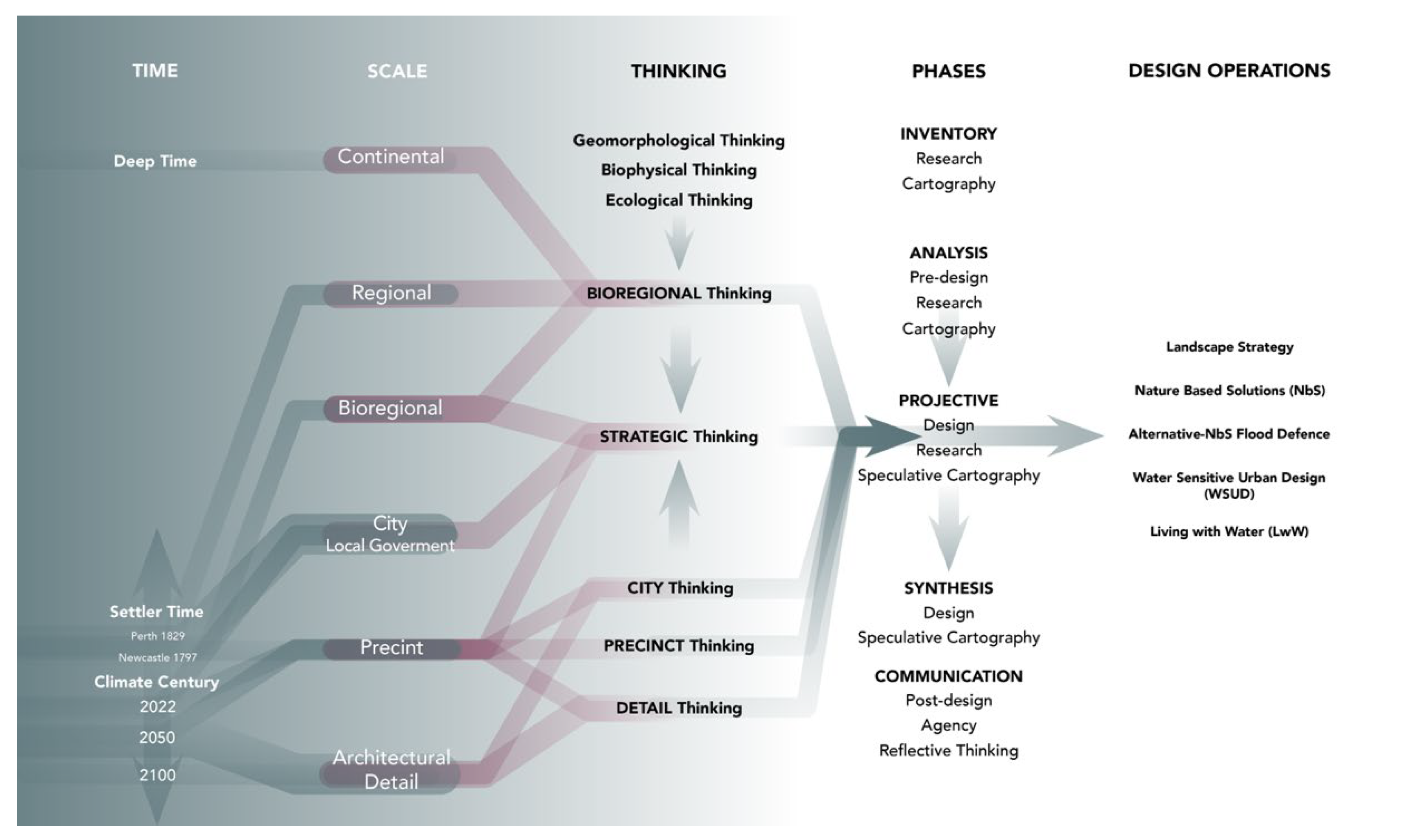
  • The analytical and inventory phase investigates the spatial-temporal site-specific conditions at bioregional, city and precinct scales. It helps identify key disciplinary fields, climate and ecological contexts and threats. This phase generates spatiotemporal cartography informing the projective phase.
  • The projective phase combines theoretical and analytical research with prospective design and speculative cartography, revealing operations and design strategies.
  • Considering the critical aspects of previous phases, the synthetic stage generates reflective thinking helping to extrapolate lessons learned to future research, design pedagogy methods, architecture, and urbanism practices and planning processes.
  • The communication phase supports the research by building a graphic and theoretical narrative that promotes co-design, collaboration, community involvement, and post-design actions, such as gradual transition or implementation.

3. Bioregional-Urban-Precinct Thinking as Projective-Explorative Design Methods

The case studies, Perth (31.9523° S, 115.8613° E), on the west coast, and Newcastle (32.9283° S, 151.7817° E), on the east coast, are located in two different Australian bioregions [45,46]. A bioregion, as defined by Robert Thayer [47], is “literally and etymologically a’ life-place’; a unique region definable by natural -rather than political- boundaries with a geographic, climatic, hydrological, and ecological character capable of supporting unique human and non-human living communities. Most importantly, it is emerging as the most logical locus and scale for a sustainable, regenerative community to take root and to take place”. Moreover, bioregional thinking is connected to the Aboriginal Australian understanding of Country, and the concepts of deep sustainability, care for ‘Country’ and deep time [36,48,49].
This methodology traverses scales and time periods to understand sites in the bioregional context of the Swan-Canning Estuary in Perth and the Hunter Estuary in Newcastle. In this paper, we use their Aboriginal names: the Bilya Estuary and the Coquun Estuary, respectfully. The Swan Coastal Plain and Sydney Basin, where the Bilya and Hunter Estuaries are located, are distinct geographical, geomorphological, biophysical, climatic, ecological, and cultural regions (Figure 2a,b). Learning from these territories’ cultural and biophysical identity supports design, helping to identify conflicts and opportunities on the catchment scales and, later, bringing the system’s intelligence into the detailed design. Bioregional thinking [44,49,50,51] and practice support design, informing how to inhabit a place and “learning to live in place” [52], in more harmonious ways. The result is a form of estuary urbanism that reconnects place with the living systems to prevent ecological destruction or correct an imbalanced equilibrium.

3.1. Bioregional-Scale to City-Scale Thinking: Geomorphological, Biophysical and Ecological Practices

Perth is the capital of WA, named after European arrival in 1829. The region’s culture and land are ancient, with continuous settlements dating back at least 65,000 years. The Whadjuk people, part of the Noongar Nation, are the Traditional Custodians of this Boodjar and land [53]. The city sits on a sandy coastal plain, the Swan Coastal Plain, beside the Yilgarn Block, an igneous plateau extending hundreds of kilometres inland thought to be the oldest geology on the planet, dated at 4.4 billion years old [54]. Over many geological epochs, sands have swept over from the ocean, and clays and sediments have been carried through flows from the Yilgarn as illustrated in Figure 2a. Several major river systems flow from the Yilgarn and become estuaries on the Plain (Figure 3a). The central estuary system framing Perth city is the Swan-Canning or Bilya Estuary (Figure 4a).
In NSW, Newcastle is the largest urban centre in the Hunter Estuary and the second settlement established by colonisers in 1804 [55]. The Traditional Custodians of the Land are the Awabakal people on the southern bank of the river, the Worimi people on the northern bank, and the Woonarua people inland [56] (Figure 2b). In this section of the coast, geology, hydrology, and sedimentary processes formed the lowlands and the coast, resulting in different types of estuaries (Figure 3b) based on the different depositional processes and barriers formation [57]. As illustrated in Figure 4b, the Hunter estuary, covered by a complex hydrological system, is formed by two barrier systems, the Tomago-Tomaree and the Stockton Sandbeds, defining an inter-barrier depression forming the Hunter Wetlands National Park, listed under the Ramsar Convention [58]. The more extensive aquifers in the bioregion are situated below the inner and outer barrier receiving the highest rate of recharge in the region [7].
Urban development poses an ongoing threat to both bioregions’ waters, biodiversity, and resilience, especially in the context of drying and warming climate trends. Species extinctions, land clearing, bushfires and water availability, were cited in Australia’s 2022 State of the Environment Report as critical future threats and drivers of instability [59]. Perth’s urbanisation and planning patterns have erased the waters and biodiversity of the coastal plain since European arrival. Despite rapid and substantial changes and extensive land clearing, Perth remains a rich and megadiverse ecosystem. This is not due to sensitive planning but rather its location within one of the most biodiverse regions on the planet—between old and young landscapes, driving phenomenal species richness and endemism [60]. Perth is regarded globally as a Hotspot City, part of the Southwest Australia Biodiversity Hotspot, one of 36 internationally recognised regions where biodiversity is in conflict with human impacts [61].
Similarly, in the Hunter Estuary, early chronicles reveal exuberant biodiversity, describing a river with rich alluvial soil, exuberant riverbanks, short tender grass clear of trees, and dense eucalypt dominated forest with “immense gum and iron-bark trees, giant cedars and graceful wattles” [56]. Mining, farming and grazed modified pastures transformed the Hunter, resulting in over 85% of the native vegetation lost [62], only 40% of forested areas retained, and 99% of riparian vegetation removed from the river and its tributaries [7,56].

3.2. City-Scale to Precinct-Scale Thinking: Ashfield

Perth is a rapidly growing and sprawling metropolis with a population of only 2.2 million that extends more than 150 kilometres along a continuously developed Indian Ocean coastline (Figure 2a). It is estimated that at least 70% of Perth’s wetlands have been filled since European settlement [63], erasing the historic wetlands of the Swan Coastal Plain (Figure 3a). The seasonal opening and closing of the estuary were interrupted by the dredging of seasonal sandbars and the explosion of the limestone estuary edges to build the Fremantle Port in the 1890s. Since then, the Bilya has transformed into a predominantly saline system, particularly in recent decades, as rainfall and streamflow have declined. Hard river edges and walls were constructed against the Estuary, transforming the soft-edged gradient.
Sprawl comes at a great cost to the lands and waters, cleared and covered by sand pads to build detached and single-storey brick-and-tile housing estates [6]. Within the city, rates of urban densification are increasing in the form of ‘infill’ housing—where single dwelling lots are cleared or reconfigured in response to densification to enable greater density. Additionally, while limiting the extent of sprawl, infill has also had many adverse impacts on urban ecology.
To accommodate population growth, water supply for drinking and irrigation has also taken its toll on water systems: rivers have been dammed to create reservoirs and bores sunk to pump water from the aquifers. By the mid-2000s, with desalination, Perth had started to manufacture its way out of a water emergency, not without substantial energy consumption. Today, Perth receives 45% of its water from desalination, which is projected to increase as the population grows. In 2004, Dr Tim Flannery stated, “Perth will be the 21st century’s first ghost metropolis”—referencing water scarcity and the drying climate.
The Perth suburb of Ashfield is located alongside the Bilya Estuary, 15 min by train to the Perth CBD. The University of Western Australia School of Design conducted a project called’ Place Value Ashfield’ to demonstrate a landscape-led approach to infill housing aligned with the living systems [64]. Ashfield’s current urban structure consists of small 1950s post-war dwellings on large lots, remaining intact due to a low-density zoning restriction. A proposed densification of Ashfield, a change that would allow for subdivision and densification across every lot, has been mooted for over a decade. The adverse impacts of densification have been well documented in Perth and other Australian cities, often resulting in the declining urban tree canopy and private open space, increasing urban heat island effects and declining surface permeability [65,66]. The emphasis in Place Value Ashfield was to ask how infill can support, rather than erode, the landscape in which it is situated, to strengthen the ecological and civic realms of the suburb.
For ‘Place Value Ashfield’, a landscape-led strategy was the vehicle for coordination and collaboration between architects, landscape architects, developers, government authorities, stakeholders, and the community, including Traditional Owners. This strategy allows the development of a shared understanding of a new and leading role that an ecological design strategy can and should play in developing Perth’s densifying suburbs.
Central to the landscape framework established for Place Value was the need to respect the vitality of the Ashfield Flats wetland system and the suburb’s surface and subsurface water flows. The biodiverse Ashfield Flats are situated on the edge of the Bilya Estuary adjacent to the suburb. They are fed by freshwater flows from the aquifers as they interface with the Bilya river system beneath Ashfield, as illustrated in Figure 5a. The Flats include sedge lands, riverine bushland and salt marsh, a nationally protected threatened ecological community. The Flats are central to the character of Ashfield, harbouring biodiversity and many benefits to residents [67]. Coupled with climate threats, one of the significant threats to the Flats is future densification in the Ashfield catchment. A declining tree canopy matrix and increasing urban heat alongside the Flats threaten the biodiversity linkages and ecologies. Increasing impervious areas threaten to alter fragile water flows to the aquifer, which sustains the Ashfield Flats.
The strategy of traversing scales and time periods to understand Ashfield in the bioregional context of Perth (Figure 2a and Figure 4a), the regional-scale biodiversity and aquifer systems was applied at the precinct scale (Figure 5a and Figure 6a). A strategic suburban framework has the potential to control and facilitate best-practice development at the site or lot scale. This strategy took the form of new landscape corridors through Ashfield to support sensitive typologies of infill housing to facilitate density while supporting and strengthening living systems. This supports similar work being done throughout Australia around ‘greenspace-oriented development’ [68].
Place Value Ashfield stepped in to address the threats to the living infrastructure of Ashfield, ensuring its future resilience. As illustrated in Figure 4a and Figure 6a, connecting to existing blue and green networks is a crucial aspect of this strategy, addressing the regional catchment context. The vital and diverse urban forest and vegetation matrix are bolstered throughout backyards, verges, and public open spaces. By reducing urban footprints and prioritising lightweight construction methods, the Ashfield housing schemes retain existing trees and the permeability of the ground, maintaining flows to the aquifer (Figure 5a). Within the urban realm, the streetscape is utilised as an animated, active, and legible movement corridor and public open space in its own right. Water-sensitive urban design is archived through rain gardens, permeable urban surfaces, and ample parkland verges, forming active ecological edges and spaces for animals and people (Figure 7a).
Increases in density are coupled with substantial upgrades to the civic realm, facilitating corridors of up-zoning between rail and river, intersecting the residential area. This coupling is new in the context of Perth, where blanket rezoning or transit-oriented rezoning are the norms. The project supported and tested ‘Design WA’, a series of new State design policies and guidelines, uncovering opportunities for coordination between lot and suburb, with up-zoning the catalyst for blue-green infrastructure.
The strategy, presented in Figure 7a, promoted housing diversity by encouraging a range of densities across the suburb and enabling a range of designers and voices to contribute to the process. The housing schemes that were part of Place Value Ashfield illustrate a diversity of typologies developed in relation to Ashfield’s unique context. Each housing scheme is integrated within the broader landscape framework, suggesting retention of and increases to tree-canopy, improved pedestrian and cycling connections, permeable and water-sensitive private and public open spaces, and new landscape-sensitive construction techniques. They establish solid urban identities appropriate to their locations within Ashfield—adjacent to rail and community facilities, parkland, urban intersections, or the river land and saltmarsh.

3.3. City-Scale to Precinct-Scale Thinking: Corrumbah–Carrington

In Newcastle, three main urban and environmental ‘scenarios’ characterised the Coquun Estuary: the floodplains, the riverine waterfront, and the coastline, as illustrated in Figure 6b. The floodplains where the city sits are dominated by urbanisation and industrial activities linked to the mining sector, heavy industry, and port facilities. Since European settlement, the estuary has suffered a dramatic transformation to critical features and ecologically devastating land reclamation and infill process, including a systematic erasure of water bodies. The riverine waterfront is being subjected to land reclamation, transforming the ‘terrain of water’ into land for industrial activities, currently transitioning into residential, commercial, and leisure uses. The coastline, its cliffs and beaches have preserved those natural features strongly linked with the community’s sense of place. However, it is vulnerable to dramatic changes in climate and weather events that compromise its stability, security, and liveability.
The suburb of Corrumbah–Carrington, is strategically located on the Coquun-Hunter Estuary, three kilometres west to the mouth, facing Thorsby and Cottage creeks on its west side and the river basin and the estuary’s mouth on the east. Like the rest of the riverine waterfront, Carrington has suffered a drastic modification of its geomorphology and ecology. The estuary has experienced substantial dredging, transforming tidal islands into the Port of Newcastle, the largest harbour on the East Coast and the world’s largest coal port [69]. Early historical maps, chronicles, and environmental history reports reveal several riverine tidal islands over the estuary, as illustrated in Figure 5b and Figure 6b, dominated by low and swampy grounds fringed with mangroves and dense vegetation of banksias or honeysuckles, tee trees, and swamp oaks [56,70,71]. The area, originally accessible only by boat or foot in lower tides, is being progressively infilled by ballast and the dumping of industrial waste, accumulating at least two meters resulting in the connection to the mainland on the north.
Carrington sits in ‘the terrain of water’ despite the land reclamation and infill. Too much water or not enough water and the intensification of storms and extreme climatic events dominate its history [7], becoming its major vulnerability. The engineering of the river to control flooding after one of the most devastating natural disasters in Australia’s history, the 1955 Maitland floods, is partly responsible for changes in the river’s basin (Figure 4b) and flow dynamics. Natural levees have been substituted by hard edges throughout the construction of channels and flood levees that have deprived the river of new layers of alluvial soil and eradicated riparian vegetation [56]. Floods are influenced by river and creek flooding episodes, tidal influence [72], oceanic inundation from high ocean tides and storm surges, and the projected impacts of sea level rise. Sea level rise projections show that 80% of Carrington will permanently be below sea level by 2100 [73] (Figure 6b).
Adaptation in Carrington requires a multiple-action approach, including responses to weather variability to cope with alternating dry and wet periods; the transition into a climate-resilient suburb model through new models of inhabitation and infrastructures; the improvement of water performance in the built environment by living with less water and optimizing water usage; and the restoration and expansion of the riverine ecological corridors. The public domain offers opportunities to develop a blue-green public water-sensitive network of roads and pedestrian pathways, public spaces and parks, and water bodies, which aligns with flood adaptative development strategies [74,75]. These require the coordination of strategies to adapt to four different scenarios: no rains and droughts, flooding associated with storm runoff and overflows, flash flooding from creeks, river flooding episodes, and ocean flooding from high water levels in the ocean and harbour, typically as a combination of big tides and storm surge and sea level rise [72].
The landscape strategy takes the form of a ‘blue-green buffer’—forming corridors connecting Carrington with Throsby Creek and beyond. The western part of Carrington, facing Throsby creek, is primarily public land, public spaces or neglected and polluted industrial land. The strip provides ‘space for the river’, acting as a blue-green buffer for Thorsby Creek flash events or flooding episodes in the wider Coquun catchment. Simultaneously, the area serves as space to retain, treat, and store water, rainwater and runoff while offering recreational, cultural, and environmental opportunities. Design strategies combine Nature based Solutions (NbS) [76,77,78,79,80], Water Sensitive Urban Design (WSUD) [74,81,82,83] and Alternative (or Nature-based) Flood Defence [81,84,85,86] to generate blue-green corridors and urban spaces acting as buffers zones to protect the urban environment and enhance natural water systems. This helps manage runoff, reduce urban heat island effects, and guarantee urban ecological connectivity to foster biodiverse corridors for flora and fauna since major environmental pressures in Newcastle LGA include the fragmentation of fauna habitats with limited integration of these in planning locally [7]. The scale of this public space buffer creates opportunities to construct green embankments and levees, terraced floodable wetlands, and floodable parks planted with mangroves and submergible planting for aesthetic and water treatment purposes, as illustrated in Figure 5b.
The green network combines strategies to connect and consolidate existing and new vegetation in the public and private domains. With the intensification of weather episodes, it is essential to increase infiltration, which helps to reduce run-off, recharge aquifers, and mitigate post-emergency events. Strategies to improve infiltration include reducing impervious surfaces with pervious paving materials, improving topsoil quality, installing infiltration trenches dotted with “treatment trains” [74,87], and urban revegetation through native scrub and trees. Due to the compacted and contaminated quality of Carrington’s soil, the topsoil quality needs to be improved, aerated, and enriched with nutrients, facilitating bacteria and fauna propagation. Special attention is required to the impacts of stormwater movement as contaminants [88] can move back into the drainage systems, severely impacting the local and regional environments [75]. Experimental phytoremediation processes utilize the power of plants to capture heavy metal pollutants in soil [89]. Additional measures revegetate shores of creeks with riverine plants and mangroves contributing to carbon sequestration and soil and water decontamination.
With a very high-water table and alluvial aquifer, and an obsolete drainage system, infiltration and runoff capacity are limited, increasing risk. Consequently, combining bioretention and detention systems, with former measures improves precinct security [74,90]. The collection, slow conveyance, and attenuation of stormwater through bioswales, street channels and open drainage integrate stormwater treatment into the urban landscape while increasing safety by reducing runoff and peak flow in intense rain periods. These measures minimise drainage infrastructure costs for development and maintenance. Stormwater runoff from developed areas impacts remnant creeks, riparian zones, and downstream wetlands. Treatment removing pollutants and water retention for reuse in drought periods are additional measures to improve water-sensitive urban performance [91]. ‘Water plazas’ inserted within the urban fabric act as public space and sport areas during dry periods and water detention or storage areas in wet seasons [92]. Together they consolidate a network of urban spaces connected through blue corridors to the ‘blue-green buffer’ [74,93,94]. “Design does not further adversely alter natural hydrology (infiltration, evapotranspiration and stormwater discharge), and ideally aims to mimic hydrological water balance” [95].
At the precinct scale, “water-wise” and “flood-resilient” typologies are integrated into a “water-sensitive” urban context through Water Sensitive Urban Design (WSUD) strategies [74,96,97] to manage and utilize the water cycle as locally as possible [65,81,98,99]. Such measures connect the built environment with the living systems, improving sustainability, urban and water security, quality of life and well-being. At the dwelling scale, the architecture integrates water servicing technologies to minimize demand, promote a decentralized urban water system and harvest stormwater for reuse, reducing reliance on imported water [95,99,100], as illustrated in Figure 7b. Additional measures include raising floor levels, waterproofing openings [101], and removing fences facilitating post-event water storage flows, reducing flood hazards. Architecture infill prototypes aim to accommodate a diversity of “water-wise” dwelling typologies responding to bio-physical principles of a water-sensitive city while responding to site and precinct-specific climate, demographic, cultural, environmental, and spatial context.

4. Discussion

This paper presented design research investigations and methods tested in two different bioregions and urban estuarine contexts. The spatiotemporal analytical phase identified vulnerabilities, challenges, and opportunities to synthesise these at bioregional, city and precinct scales. The projective phase formulated adaptative design interventions and Water Sensitive Urban Design and housing typologies, understanding the dynamic and transformative characteristics of designing in the “terrain of water”. Time operates as a tool of design understanding the gradual implementation of measures due to the system’s dynamism and the unpredictability of phenomena. Acknowledging and identifying the differences and commonalities of larger territorial systems in both estuaries informs urban and precinct scales, bringing the system’s intelligence into detailed design and vice versa. Simultaneously, this research helps to develop ‘replicable’ methodologies, with strategies, design research and design educational methods applicable across other estuary cities.

4.1. Key Findings and Lessons Learnt

The precinct-scale projects at Ashfield and Carrington demonstrate the design research approach described in this article, crossing scales, timeframes, and disciplines. This action is an approach of grounding urbanism within a broader framework of place—expanding the definition of site to understand strategies at the scale of the territory, the city and the system. The areas are essential case studies highlighting the urban–biodiversity conflict and, at the same time, opportunities for resolution and resilience in a changing climate. They are areas where ongoing urban development and densification are projected to conflict with the environment. Therefore, they are key scenarios to demonstrate the harmonization of urbanism with ecological and hydrological systems toward transformative spatial planning and design. These are flashpoints where future ‘resilience by design’ is tested and highlighted to the community and policymakers [82,102].
Descriptive design research, followed by projective design research, demonstrates the continuity between site-specific and complex urban-environmental contexts and design strategies. Working visually and spatially between descriptive and projective methods has been critical in testing, visualising, and developing both projects at Ashfield and Carrington. Together, these modes of design research have enabled a better understanding of the importance of Ashfield’s unique ecology and hydrology and ways forward to doing density well. It serves as an example of how ecological design strategies can be incorporated into future practices and design guidelines to impact wider urban areas. In Carrington, the post-industrial scenario, and the challenges of climate security claim for a new urban and ecological paradigm reformulating low-density residential areas and promoting medium sustainable density models, connecting hydrological and ecological system with the built environment. These aim to build adaptative urban security and urban ecological security in the post-coal city.
In both Ashfield and Carrington, the design research methodology and ‘water-wise’ design strategies crosses scales—Bioregion, catchment, urban, precinct and plot- to understand historical ecology and hydrology. Adaptation measures involve long planning horizons, long-term significant investments and consensus [81]. Time imposes a strategic approach to design by proposing a gradual implementation that adjusts dynamically to the living systems, economic constraints, and the unpredictable character of climate and the environment in the long term. In doing so, it enters a domain of what Anne Spirn called ‘deep structure’ [103]—seeing beneath the city and following Traditional Owners in listening to the place and across time. While the forces of planning and development move quickly, many of these approaches seek to move slower at what Kate Orff, director of US landscape practice SCAPE, called ‘the speed of trust’ —to leave the agency for community and culture to interpret and act, and of course for future generations.

4.2. Key Theoretical and Methodological Contribution

The research contributes to critical theories of urbanism and climate adaptation by implementing a four-step methodology, aligned with the design research methods, to operate in estuary cities in the Climate Century, working radically with natural systems and establishing water as a ground of settlement. This methodology contributes to work previously or contemporary developed by researchers, practitioners and institutions within Australia [11,65,95,100] and internationally [21,104,105]. Remarkable initiatives within Australia are the Cooperative Research Centre for Water Sensitive Cities [106] and Water by Design [83], the result of the partnership of Australian Governments, universities and industry providing platforms to promote interdisciplinary research and translate to programmes, guidelines and actions. Lessons learned must be urgently translated into innovative, dynamic, and operational design guidelines and policies at national, regional, and local scales, informing guidelines and policies at multiple scales and all levels of planning.
A fundamental goal achieved is the creation of site-specific design strategies that provide insight into how to operate in low to medium-density precincts to make them part of larger ecosystems and hydrological catchments, improving urban sustainability and resilience. Nevertheless, further design research is necessary to investigate estuary and coastal areas across various scales and through time. Future research will test design strategies by modelling and simulating flooding scenarios through tridimensional physical and computational hydrodynamic models. The models will check the efficiency of adaptative simulations and develop multiple scenarios to adapt to an unpredictable evolution.
The methodology and strategic thinking applied in university design studios enhance students’ analytical, critical and design skills. This methodology operates as a pedagogical tool, educating future designers to approach urban, climate and ecological issues critically and strategically. Working through scales, time periods and disciplines connect students with the site, culture, and environment, nurturing future generations’ education in the structures and systems of the city.

4.3. Limitations and Future Research

Water Sensitive Urban Design and Nature-based Solutions are being incorporated into design disciplines’ theoretical research, practice, and teaching, informing current urban practices and urbanism. They are essential to reconnect natural and built environments by re-naturalising creeks, riverine and coastal waterfronts, and reconnecting disconnected urban and natural green areas. Moreover, Nature-based Flood Defence and Blue-Green infrastructures provide an alternative to hard infrastructures, facilitating soft interventions that protect the built environment from dramatic climate and weather events. However, more research and collaboration are needed, and new interdisciplinary and multi-agent alliances are necessary to implement and test the effectiveness of speculative and experimental models. These strategies and actions require significant investment, community involvement and strategic thinking to respond to major challenges and, secondly, to incorporate them in time and over time and within economic constraints. The approach demands flexibility to adapt to unpredictable and dynamic systems, the human including the non-human. We must consider the options today to prepare for these changing futures.
The urgency of action requires an interdisciplinary integration of scientific insight, engineering, design, planning and governance—across sectors. Collaboration between intergovernmental bodies, research institutions, practice and industry, policymakers, community, and other stakeholders can inform policies and guidelines, interconnected internationally, nationally, regionally, and locally. Local governments and planning institutions are essential in promoting policies and guidelines, and the regional and federal governments in financing flood resilience and blue-green agendas. There is a clear gap between adaptation planning and measure implementation, “which is a problem that impedes effective climate adaptation” [107]. The urgency of climate adaptation contrasts with reality in Australia due to different agendas amongst regions and the limitation of local authorities. These processes reveal the importance of collaboration of a range of spatial, environmental, and governmental actors in working toward resilient futures. Will we repeat the error of the past and continuously replicate business-as-usual development models? Or will we accept the impacts of climate change and work towards designing and managing an adaptive city and corresponding architecture?
Business-as-usual development relies on complex processes mainly opaque to the community and immune to critical discussion. To get behind sustainable and resilient trajectories, collective decision-making needs to understand futures as multiple and alternative, rather than inevitable. Communities play a fundamental role in holding and transferring knowledge about the places in which they live. Moreover, the societal role is essential in advancing new urban agendas and making environmental shifts through valuable contributions to the future of their cities [82].

5. Conclusions

An ‘Estuary Urbanism’ challenges bounded thinking imposed by planning frameworks that ‘see’ and address edges and boundaries rather than flows or systems, crossing physical scales and timescales. Unsurprisingly, the planning orthodoxies that still govern our cities were developed long before an environmental sensibility or awareness of climate change emerged. Estuaries exist in flux and flow—they are not bounded, but ‘breathing’—and the cities surrounding them are asked to develop similarly. A transition to new climate regimes will shift planning and design toward new ways of engaging with place and with the environment. Design in ‘the terrain of water’ means designing to live with water and natural systems. The importance of working visually and spatially through design methods to demonstrate and implement these new engagements has never been more critical.

Author Contributions

Conceptualization, I.P.L. and D.J.M.; methodology, I.P.L.; investigation, I.P.L. and D.J.M.; resources, I.P.L. and D.J.M.; writing—original draft preparation, I.P.L. and D.J.M.; writing—review and editing, I.P.L. and D.J.M.; visualization, I.P.L. and D.J.M.; funding acquisition, I.P.L. All authors have read and agreed to the published version of the manuscript.

Funding

This research was funded by the University of Newcastle 2022 Research Advantage Women in Research.

Institutional Review Board Statement

Not applicable.

Informed Consent Statement

Not applicable.

Data Availability Statement

Not applicable.

Acknowledgments

We acknowledge the Traditional Custodians of the land on which the University of Newcastle and the University of Western Australia reside. We pay our respect to Elders past, present, and emerging. We extend this acknowledgement to the Awabakal people of the land on which the Callaghan Campus resides and to the Whadjuk people in Western Australia, where the Crawley Campus is situated on the Bilya. Thank you to the following individuals and institutions who have been an inspiration and/or kindly helped locate and provide research resources: Gionni Di Gravio (University Archivist, Special Collections), University of Newcastle Library and librarians, State Library of New South Wales. Special thanks to Callum Twomey, Jye Whyte, Mia Tulumovic and Nur Jihan Nabilah Nordin, research assistants in this project. Thank you to Place Value Ashfield collaborators Rosie Halsmith and Loren Holmes and Future West (Australian Urbanism). Place Value Ashfield was collectively developed, integrating the thoughts of many. Thank you to all the contributors to this project. Please see www.placevalueashfield.com (accessed on 5 June 2022) for more information about this project.

Conflicts of Interest

The authors declare no conflict of interest.

References

  1. McGranahan, G.; Balk, D.; Anderson, B. The rising tide: Assessing the risks of climate change and human settlements in low elevation coastal zones. Environ. Urban. 2007, 19, 17–37. [Google Scholar] [CrossRef]
  2. Oppenheimer, M.; Glavovic, B.C.; Hinkel, J.; van de Wal, R.; Magnan, A.K.; Abd-Elgawad, A.; Cai, R.; Cifuentes-Jara, M.; DeConto, R.M.; Ghosh, T.; et al. Sea Level Rise and Implications for Low-Lying Islands, Coasts and Communities. In The Ocean and Cryosphere in a Changing Climate: Special Report of the Intergovernmental Panel on Climate Change; Cambridge University Press: Cambridge, UK, 2022; pp. 321–446. [Google Scholar] [CrossRef]
  3. Intergovernmental Panel on Climate Change. Australasia. In Climate Change 2014: Impacts, Adaptation, and Vulnerability. Part B: Regional Aspects. Contribution of Working Group II to the Fifth Assessment Report of the Intergovernmental Panel on Climate Change; Cambridge University Press: Cambridge, UK, 2014; pp. 1371–1438. [Google Scholar]
  4. UNESCO. UN-Water. In The United Nations World Water Development Report 2020: Water and Climate Change; UNESCO: Paris, France, 2020; Volume 2020. [Google Scholar]
  5. Ovink, H. Water as catalyst for sustainable development. J. Delta Urban. 2020, 1, 61–69. [Google Scholar]
  6. Weller, R. Boomtown 2050: Scenarios for a Rapidly Growing City; UWA Publishing: Crawley, Australia, 2009; ISBN 978-1921401-21-3. [Google Scholar]
  7. McVicar, T.; Pinetown, K.; Hodgkinson, J.; Barron, O.; Rachakonda, P.K.; Zhang, Y.; Dawes, W.; Macfarlane, C.; Holland, K.; Marvanek, S.; et al. Context Statement for the Hunter Subregion, Product 1.1 for the Hunter Subregion from the Northern Sydney Basin Bioregional Assessment; Department of the Environment, Bureau of Meteorology, CSIRO and Geoscience Australia: Symonston, Australia, 2015.
  8. Glamore, W.; Mitrovic, S.; Ruprecht, J.; Dafforn, K.; Scanes, P.; Ferguson, A.; Rayner, D.; Miller, B.; Dieber, M.; Tucker, T.; et al. The Hunter River Estuary Water Quality Model. In Proceedings of the Australasian Coasts & Ports 2019 Conference, Hobart, Australia, 10–13 September 2019. [Google Scholar]
  9. Hunter Estuary Processes Study Summary Report; NSW Department of Public Work and Service Manly Hydraulics Laboratory: Manly Vale, Australia, 2002.
  10. Priemus, H.; Rietveld, P. Climate Change, Flood Risk and Spatial Planning. Built Environ. 2009, 35, 425–431. [Google Scholar] [CrossRef]
  11. Bertram, N.; Murphy, C. Time with Water: Design Studies of 3 Australian Cities; UWA Publishing: Crawley, Australia, 2019. [Google Scholar]
  12. Meyer, H. Delta Urbanism coming of age: 25 years of Delta Urbanism where are we now? J. Delta Urban. 2020, 1, 15–35. [Google Scholar] [CrossRef]
  13. Costanza, R.; d’Arge, R.; de Groot, R.; Farber, S.; Grasso, M.; Hannon, B.; Limburg, K.; Naeem, S.; O’Neill, R.V.; Paruelo, J.; et al. The value of the world’s ecosystem services and natural capital. Ecol. Econ. 1998, 25, 3–15. [Google Scholar] [CrossRef]
  14. Dammers, E.; Bregt, A.K.; Edelenbos, J.; Meyer, H.; Pel, B. Urbanized Deltas as Complex Adaptive Systems: Implications for Planning and Design. Built Environ. 2014, 40, 156–168. [Google Scholar] [CrossRef]
  15. Wu, J. Landscape sustainability science: Ecosystem services and human well-being in changing landscapes. Landsc. Ecol. 2013, 28, 999–1023. [Google Scholar] [CrossRef]
  16. Pörtner, H.O.; Roberts, D.C.; Poloczanska, E.S.; Mintenbeck, K.; Tignor, M.; Alegria, A.; Craig, M.; Langsdorf, S.; Löschke, S.; Möller, V.; et al. (Eds.) IPCC, 2022: Summary for Policymakers. In Climate Change 2022: Impacts, Adaptation and Vulnerability. Contribution of Working Group II to the Sixth Assessment Report of the Intergovernmental Panel on Climate Change; Cambridge University Press: Cambridge, UK; New York, NY, USA, 2022; pp. 3–33. [Google Scholar]
  17. Diedric, L. Richard Weller. Boomtown 2050: Scenarios for a Rapidly Growing City. UWA Publishing, 2009. ISBN 978-1921401-21-3, 454 pages. J. Landsc. Archit. 2010, 2010, 87. [Google Scholar]
  18. Díaz, S.; Fargione, J.; Chapin, F.S., III; Tilman, D. Biodiversity Loss Threatens Human Well-Being. PLoS Biol. 2006, 4, e277. [Google Scholar] [CrossRef] [Green Version]
  19. Hodson, M.; Marvin, S. ‘Urban Ecological Security’: A New Urban Paradigm? Int. J. Urban Reg. Res. 2009, 33, 193–215. [Google Scholar] [CrossRef]
  20. Kennish, M.J. Environmental threats and environmental future of estuaries. Environ. Conserv. 2002, 29, 78–107. [Google Scholar] [CrossRef]
  21. Mathur, A.; da Cunha, D. Design in the Terrain of Water; Applied Research + Design Publishing: San Francisco, CA, USA, 2014. [Google Scholar]
  22. Roggema, R. The future of sustainable urbanism: A redefinition. City Territ. Archit. 2016, 3, 22. [Google Scholar] [CrossRef] [Green Version]
  23. Bell, S.; Fleming, L.E.; Grellier, J.; Kuhlmann, F.; Nieuwenhuijsen, M.J.; White, M.P. Urban Blue Spaces: Planning and Design for Water, Health and Well-Being; Routledge: New York, NY, USA, 2022. [Google Scholar]
  24. Jonkman, B.; Ovink, H. On sustainable delta development: Sustainable coastal adaptation is possible—Water as catalyst for sustainable development. J. Delta Urban. 2020, 1. [Google Scholar] [CrossRef]
  25. Meyer, H. Delta-Urbanism: New Challenges for Planning and Design in Urbanized Deltas. Built Environ. 2014, 40, 148–155. [Google Scholar] [CrossRef]
  26. Meyer, H. Reinventing the Dutch Delta: Complexity and Conflicts. Built Environ. 2009, 35, 432–451. [Google Scholar] [CrossRef]
  27. Fields, B.; Thomas, J.; Wagner, J.A. Living with Water in the Era of Climate Change: Lessons from the Lafitte Greenway in Post-Katrina New Orleans. J. Plan. Educ. Res. 2017, 37, 309–321. [Google Scholar] [CrossRef]
  28. Mathur, A.; Da Cunha, D. Deccan Traverses: The Making of Bangalore’s Terrain; Rupa: New Delhi, India, 2006. [Google Scholar]
  29. Biggs, R.; Schluter, M.; Schoon, M.L. Principles for Building Resilience: Sustaining Ecosystem Services in Social-Ecological Systems; Cambridge University Press: Cambridge, UK, 2015. [Google Scholar] [CrossRef] [Green Version]
  30. Psarra, I.; Altınkaya Genel, Ö.; van Spijk, A. A Research by Design Strategy for Climate Adaptation Solutions: Implementation in the Low-Density, High Flood Risk Context of the Lake District, UK. Sustainability 2021, 13, 11847. [Google Scholar] [CrossRef]
  31. Cin, F.D.; Hooimeijer, F.L.; Silva, M.M. Planning the urban waterfront transformation, from infrastructures to public space design in a sea-level rise scenario: The european union prize for contemporary architecture case. Water 2021, 13, 218. [Google Scholar] [CrossRef]
  32. Mattei, J.H. Structures of Coastal Resilience. In The Quarterly Review of Biology; University of Chicago Press: Chicago, IL, USA, 2019; pp. 307–308. [Google Scholar] [CrossRef]
  33. Deming, M.E.; Swaffield, S. Landscape Architectural Research: Inquiry, Strategy, Design; John Wiley & Sons: Hoboken, NJ, USA, 2011. [Google Scholar]
  34. Barbosa, D.Q.; Rosa, E.; Gerrits, Y.; De Meulder, B. Design studio as a process of inquiry: The case of Studio Sao Paulo. Lusofona J. Archit. Educ. 2014, 11, 241–254. [Google Scholar]
  35. Roggema, R. Research by Design: Proposition for a Methodological Approach. Urban Sci. 2017, 1, 2. [Google Scholar] [CrossRef]
  36. Yunkaporta, T. Sand Talk: How Indigenous Thinking can Save the World; Text Publishing: Melbourne, Autralia, 2019. [Google Scholar]
  37. Heracleous, L. Strategic thinking or strategic planning? Long Range Plan. 1998, 31, 481–487. [Google Scholar] [CrossRef]
  38. Bishop, P.; Williams, L. Design for London: Experiments in Urban Thinking; UCL Press: London, UK, 2020. [Google Scholar] [CrossRef]
  39. Liedtka, J.M. Strategic thinking: Can it be taught? Long Range Plan. 1998, 31, 120–129. [Google Scholar] [CrossRef]
  40. Graetz, F. Strategic thinking versus strategic planning: Towards understanding the complementarities. Manag. Decis. 2002, 40, 456–462. [Google Scholar] [CrossRef]
  41. Colquhoun, G.P.; Hughes, K.S.; Deyssing, L.; Ballard, J.C.; Folkes, C.B.; Phillips, G.; Troedson, A.L.; Fitzherbert, J.A. New South Wales Seamless Geology Dataset (Single Layer), version 2.2; Geological Survey of New South Wales: Maitland, Australia, 2022. [Google Scholar]
  42. Crossman, S.; Li, O. Surface Hydrology Polygons and Surface Hydrology Lines (National); Geoscience Australia: Canberra, Australia, 2015. [Google Scholar]
  43. Australia, Government of Western Australia. DataWA. 2021. Available online: https://data.wa.gov.au (accessed on 13 October 2022).
  44. Lynch, T.; Glotfelty, C.; Armbruster, K.; Zeitler, E.J. Ebook Central—Academic Complete. In The Bioregional Imagination: Literature, Ecology, and Place; University of Georgia Press: Athens, Georgia, 2012. [Google Scholar]
  45. Department of Climate Change. The Environment and Water. Australia’s Bioregion (IBRA). 2021. Available online: https://www.dcceew.gov.au/environment/land/nrs/science/ibra (accessed on 7 July 2022).
  46. Department of Climate Change. The Environment and Water. Australia’s Ecoregions. 2021. Available online: https://www.dcceew.gov.au/environment/land/nrs/science/ibra/australias-ecoregions (accessed on 7 July 2022).
  47. Thayer, R.L. Lifeplace: Bioregional Thought and Practice; University of California Press: Berkeley, CA, USA, 2004; Volume 28, pp. 416–417. [Google Scholar]
  48. Berrizbeitia, A. Between Deep and Ephemeral Time: Representations of Geology and Temporality in Charles Eliot’s Metropolitan Park System, Boston (1892–1893). Stud. Hist. Gard. Des. Landsc. 2014, 34, 38–51. [Google Scholar] [CrossRef]
  49. McGinnis, M.V. Bioregionalism; Routledge: Oxford, UK, 1999. [Google Scholar]
  50. Thayer, R.L. Introduction. Bioregional Thinking. In LifePlace: Bioregional Thought and Practice; University of California Press: Berkeley, CA, USA, 2019; pp. 1–10. [Google Scholar] [CrossRef]
  51. Von Krogh, L. Bioregionalism: An Alternative Vision for Sustainability; Routledge: London, UK, 1999. [Google Scholar]
  52. Berg, P.; Dasmann, R. Reinhabiting California. In The Biosphere and the Bioregion; Routledge: Oxford, UK, 1977; pp. 399–401. [Google Scholar]
  53. Leybourne, M.; Gaynor, A. Water: Histories, Cultures, Ecologies; University of Western Australia Press: Crawley, Australia, 2006. [Google Scholar]
  54. Valley, J.W.; Graham, C.M.; Wilde, S.A.; Peck, W.H. Evidence from detrital zircons for the existence of continental crust and oceans on the Earth 4.4 Gyr ago. Nature 2001, 409, 175–178. [Google Scholar] [CrossRef]
  55. Di Gravio, G.A. Virtual Sourcebook for Aboriginal Studies in the Hunter Region Guide: 1800-1819; The University of Newcastle: Callaghan, Australia, 2019. [Google Scholar]
  56. Albrecht, G. Rediscovering the Coquun: Towards an environmental history of the Hunter River. In Proceedings of the River Forum 2000, Hunter Valley, Australia, 6–10 June 2000. [Google Scholar]
  57. Roy, P.S.; Williams, R.J.; Jones, A.R.; Yassini, I.; Gibbs, P.J.; Coates, B.; West, R.J.; Scanes, P.R.; Hudson, J.P.; Nichol, S. Structure and Function of South-east Australian Estuaries. Estuar. Coast. Shelf Sci. 2001, 53, 351–384. [Google Scholar] [CrossRef]
  58. Roy, P.S.; Boyd, R. Quaternary Geology of Southest Australia: A Tectonically Stable, Wave-Dominated, Sediment-Deficient Margin; Geological Survey of New South Wales, Department of Mineral Resources: Sydney, Australia, 1996; p. 174.
  59. Logan, T. State of the Environment Report Highlights Mammal Extinctions and Bushfires as WA Worries. 2022. Available online: https://www.abc.net.au/news/2022-07-20/western-australia-state-of-the-environment-report-grim-outlook/101248650?utm_campaign=abc_news_web&utm_content=link&utm_medium=content_shared&utm_source=abc_news_web (accessed on 7 July 2022).
  60. Hopper, S.D. OCBIL theory: Towards an integrated understanding of the evolution, ecology and conservation of biodiversity on old, climatically buffered, infertile landscapes. Plant Soil 2009, 322, 49–86. [Google Scholar] [CrossRef]
  61. Weller, R.; Hoch, C.; Huang, C. The Atlas for the End of the World. 2017. Available online: https://atlas-for-the-end-of-the-world.com (accessed on 13 October 2022).
  62. McManus, P.; O’Neill, P.; Loughran, R.; Lescure, O.R. Sustainability in the Hunter Region. In Journeys: The Making Of the Hunter Region; Allen & Unwin: Sydney, Australia, 2000; pp. 246–267. [Google Scholar]
  63. Bucktin, H.; Shotter, V. Living Wetlands: An Introduction to Wetlands; Government of Western Australiaeast: Perth, Australia, 2001.
  64. Martin, D.J.; Holmes, L.; Halsmith, R. Doing Density Differently: A New, Landscape-Led Approach to Infill Housing. 2021. Available online: https://www.foreground.com.au/culture/doing-density-differently-a-new-landscape-led-approach-to-infill-housing/ (accessed on 5 June 2022).
  65. Murray, S.; Bertram, N.; Khor, L.-A.; Rowe, D.; Meyer, B.; Murphy, C.; Newton, P.; Glackin, S.; Alves, T.; McGauran, R. Processes for Developing Affordable and Sustainable Medium-Density Housing Models for Greyfield Precincts; Monash University: Melbourne, Australia, 2015. [Google Scholar]
  66. Department of Planning, Government of Western Australia 2017 to 2022. Draft Medium Density Code. 2022. Available online: https://www.wa.gov.au/government/document-collections/draft-medium-density-code (accessed on 3 May 2022).
  67. Department of Climate Change, Energy, the Environment and Water. Subtropical and Temperate Coastal Saltmarsh in Community and Species Profile and Threats Database. 2022. Available online: http://www.environment.gov.au/cgi-bin/sprat/public/sprat.pl (accessed on 12 June 2022).
  68. Bolleter, J.; Ramalho, C.E. Greenspace-Oriented Development: Reconciling Urban Density and Nature in Suburban Cities, 1st ed.; Springer International Publishing: Cham, Switzerland, 2020. [Google Scholar]
  69. Bairstow, D. Hydraulic Power and Coal Loading at Newcastle Harbour, Nrew South Wales. Aust. J. Hist. Archeol. 1986, 4, 57–66. [Google Scholar]
  70. Dangar, H. Index and Directory to Map of the Country Bordering Upon the River Hunter; Joseph Cross: London, UK, 1828. [Google Scholar]
  71. Coulin, E. History of Carrington; Hunter Living Histories; The University of Newcastle: Callaghan, Australia, 1995; Available online: https://hunterlivinghistories.com/wp-content/uploads/2014/04/historyofcarrington-tedcoulin.pdf (accessed on 13 October 2022).
  72. Haines, P. The Newcastle City-wide Floodplain Risk Management Study and Plan Compendium of Maps; The City of Newcastle: Newcastle upon Tyne, UK, 2012. [Google Scholar]
  73. Newcastle, T.C.O. Newcastle Coastal Zone Management Plan; The City of Newcastle: Newcastle upon Tyne, UK, 2018. [Google Scholar]
  74. Wong, T.H.F. Australian Runoff Quality. A guide to Water Sensitive Urban Design; Media, E., Ed.; Engineers Australia: Barton, Australia, 2006. [Google Scholar]
  75. Franco-Torres, M.; Rogers, B.C.; Harder, R. Articulating the new urban water paradigm. Crit. Rev. Environ. Sci. Technol. 2021, 51, 2777–2823. [Google Scholar] [CrossRef]
  76. Chausson, A.; Turner, B.; Seddon, D.; Chabaneix, N.; Girardin, C.A.J.; Kapos, V.; Key, I.; Roe, D.; Smith, A.; Woroniecki, S.; et al. Mapping the effectiveness of nature-based solutions for climate change adaptation. Glob. Change Biol. 2020, 26, 6134–6155. [Google Scholar] [CrossRef]
  77. Morris, R.L.; Konlechner, T.M.; Ghisalberti, M.; Swearer, S.E. From grey to green: Efficacy of eco-engineering solutions for nature-based coastal defence. Glob. Change Biol. 2018, 24, 1827–1842. [Google Scholar] [CrossRef]
  78. Roggema, R.; Proquest, E.C. Nature Driven Urbanism; Springer: Cham, Switzerland, 2020. [Google Scholar]
  79. Garrard, G.E.; Williams, N.S.G.; Mata, L.; Thomas, J.; Bekessy, S.A. Biodiversity Sensitive Urban Design. Conserv. Lett. 2017, 11, e12411. [Google Scholar] [CrossRef]
  80. Nature-based Solutions Evidence Platform. University of Oxford; Oxford Martin School; NERC Science of the Environment. Available online: https://www.naturebasedsolutionsevidence.info (accessed on 12 July 2022).
  81. Gersonius, B.; Richard, A.; Salinas-Rodríguez, C.; Rijke, J.; Radhakrishnan, M.; Zevenbergen, C. Flood Resilience in Water Sensitive Cities. 2016. Available online: https://www.researchgate.net/publication/324836770_Flood_resilience_in_Water_Sensitive_Cities_Guidance_for_enhancing_flood_resilience_in_the_context_of_an_Australian_water_sensitive_city_Flood_Resilience_in_Water_Sensitive_Cities_Guidance_for_enhancin (accessed on 12 July 2022).
  82. Rogers, B.C.; Gunn, A.W. Towards a Water Sensitive Elwood: A Community Vision and Transition Pathways; CRC for Water Sensitive Cities: Clayton, VI, USA, 2017. [Google Scholar]
  83. Water by Design. 2020. Available online: https://waterbydesign.com.au/download-category/water-sensitive-urban-design (accessed on 3 December 2022).
  84. Moore, D.R. The Prehistory of the Hunter River Valley. In Australian Natural History; The Australian Museum: Sydney, Australian, 1969; pp. 166–171. [Google Scholar]
  85. Qi, Y.; Shun Chan, F.K.; Griffiths, J.; Feng, M.; Sang, Y.; O’Donnell, E.; Hutchins, M.; Thadani, D.R.; Li, G.; Shao, M.; et al. Sponge City Program (SCP) and Urban Flood Management (UFM)—The Case of Guiyang, SW China. Water 2021, 13, 2784. [Google Scholar] [CrossRef]
  86. Chiu, Y.-Y.; Raina, N.; Chen, H.-E. Evolution of Flood Defense Strategies: Toward Nature-Based Solutions. Environments 2022, 9, 2. [Google Scholar] [CrossRef]
  87. Moravej, M.; Renouf, M.A.; Lam, K.L.; Kenway, S.J.; Urich, C. Site-scale Urban Water Mass Balance Assessment (SUWMBA) to quantify water performance of urban design-technology-environment configurations. Water Res. 2021, 188, 116477. [Google Scholar] [CrossRef] [PubMed]
  88. Glamore, W.; Mitrovic, S.; Ruprecht, J.; Dafforn, K.; Scanes, P.; Ferguson, A.; Rayner, D.; Miller, B.; Dieber, M.; Tucker, T.; et al. (Eds.) Surrounding the Hunter, the alluvial aquifers that extend below the river, main creeks and subsidiaries are highly polluted and contain high salinity levels due to mining, industrial activities, and tidal influence. In The Hunter River Estuary Water Quality Model, Proceedings of the Australasian Coasts & Ports 2019 Conference, Hobart, Australia, 10–13 September 2019; Engineers Australia: Barton, Australia, 2019. [Google Scholar]
  89. Ware, S.; Johnstone, C.; Sparks, K.; Allan, P.; Bryant, M.; Murray, A. Power Plants. Phytoremediation Gardens; NSW Government, Landcom: Sydney, Australia, 2018.
  90. Xiao, Q.; McPherson, E.G.; Zhang, Q.; Ge, X.; Dahlgren, R. Performance of two bioswales on urban runoff management. Infrastructures 2017, 2, 12. [Google Scholar] [CrossRef] [Green Version]
  91. Berry Gersonius, R.A.; Salinas-Rodríguez, C.; Rijke, J.; Radhakrishnan, M.; Zevenbergen, C. Flood Resilience in Water Sensitive Cities; Cooperative Research Centre for Water Sensitive Cities: Clayton, Australia, 2016. [Google Scholar]
  92. Boer, F.; Jorritsma, J.; Van Peijpe, D. De Urbanisten and the Wondrous Water Square; 010 Publishers: Rotterdam, The Netherlands, 2010. [Google Scholar]
  93. Leinster, S.; Allison, R.; McCann, D. Construction and Establishment Guidelines: Swales, Bioretention Systems and Wetlands; South East Queensland Healthy Waterways Partnership Office: Brisbane, Australia, 2010. [Google Scholar]
  94. Ekka, S.A.; Rujner, H.; Leonhardt, G.; Blecken, G.-T.; Viklander, M.; Hunt, W.F. Next generation swale design for stormwater runoff treatment: A comprehensive approach. J. Environ. Manag. 2021, 279, 111756. [Google Scholar] [CrossRef]
  95. London, G.; Bertram, N.; Sainsbury, O.; Todorovic, T. Infill Typologies Catalogue—Revision A.; Cooperative Research Centre for Water Sensitive Cities: Melbourne, VI, USA, 2020. [Google Scholar]
  96. Design. The Water Wise House. Water by Design. Healthy Land & Water, Brisbane, Queensland. 2022. Available online: https://waterbydesign.com.au/download-category/water-sensitive-urban-design (accessed on 3 December 2022).
  97. Moore, R. Private Water Supply; Engineers Australia: Barton, Australia, 2004; pp. 386–391. Available online: https://go.exlibris.link/K1jJ8M6T (accessed on 3 December 2022).
  98. Argue, J.R.; Barton, A.B. A Review of the Application of Water Sensitive Urban Design (WSUD) to Residential Development in Australia. Aust. J. Water Resour. 2007, 11, 31–40. [Google Scholar]
  99. Moravej, M.; Renouf, M.A.; Kenway, S.; Urich, C. What roles do architectural design and on-site water servicing technologies play in the water performance of residential infill? Water Res. 2022, 213, 118109. [Google Scholar] [CrossRef]
  100. Renouf, M.; Kenway, S.; Bertram, N.; London, G.; Todorovic, T.; Sainsbury, O.; Nice, K.; Moravej, M.; Sochacka, B. Water Sensitive Outcomes for Infill Development: Infill Performance Evaluation Framework; Cooperative Research Centre for Water Sensitive Cities: Melbourne, Australia, 2020. [Google Scholar]
  101. Rogers, B.; Bertram, N.; Gersonius, B.; Gunn, A.; Löwe, R.; Murphy, C.; Pasman, R.; Radhakrishnan, M.; Urich, C.; Wong, T. An interdisciplinary and catchment approach to enhancing urban flood resilience: A Melbourne case. Philos. Trans. R. Soc. A 2020, 378, 20190201. [Google Scholar] [CrossRef]
  102. Siegel, Z.; Brown-Stevens, A.; Greenbaum, E. Resilient By Design: Bay Area Challenge. California Coastal Conservancy: Oakland, CA, USA; Available online: https://drive.google.com/file/d/13DkPzVCUyHVwnHpnGo0Bu8B87n3VfTjV/view (accessed on 3 December 2022).
  103. Spirn, A.W. Urban Ecosystems, City Planning, and Environmental Education: Literature, Precedents, Key Concepts, and Prospects. In Understanding Urban Ecosystems; Springer: Berlin/Heidelberg, Germany, 2003; pp. 201–212. [Google Scholar]
  104. Meyer, H.; Nijhuis, S. Delta urbanism: Planning and design in urbanized deltas—comparing the Dutch delta with the Mississippi River delta. J. Urban. Int. Res. Placemak. Urban Sustain. 2013, 6, 160–191. [Google Scholar] [CrossRef]
  105. Lehrman, B. SOAK: Mumbai in an Estuary Anuradha Mathur and Dilip da Cunha. Landsc. J. 2011, 30, 315–317. [Google Scholar] [CrossRef]
  106. Cooperative Research Centre for Water Sensitive Cities (CRCWSC). 2021. Available online: https://watersensitivecities.org.au (accessed on 3 December 2022).
  107. Radhakrishnan, M.; Pathirana, A.; Ashley, R.; Zevenbergen, C. Structuring climate adaptation through multiple perspectives: Framework and case study on flood risk management. Water 2017, 9, 129. [Google Scholar] [CrossRef]
Figure 1. Methodological Diagram incorporating time, scales, strategies & design phases.
Sustainability 15 00962 g001
Figure 2. (a) Bioregional scale map showing the Swan Coastal Plain and Darling Scarp Bioregions defined clearly by their topography; (b) Hydrological, geomorphological, and cultural systems in the Hunter Bioregion, part of the Sydney Bioregion (and Sedimentary Basin).
Sustainability 15 00962 g002aSustainability 15 00962 g002b
Figure 3. (a) Bioregional mapping of the historic wetlands of the Swan Coastal Plain, today many of these have been covered by the sprawling urban footprint of Perth; (b) Hunter Bioregion Coastal Estuaries and Hydrological systems (South to North): Hawkesbury River, Brisbane Water, Tuggerah Lake-Budgewoi Lake-Lake Munmorah-Colongra Lake-Mannering Lake, Lake Macquarie [Awaba], Hunter River Estuary (Coquun), Karuah River.
Sustainability 15 00962 g003
Figure 4. (a) City scale mapping of the contemporary blue and green networks of Perth, centering on the Bilya—Swan-Canning Estuary. (b) Hunter River Estuary and Hydrological systems: Hunter River Estuary, Hunter Wetland National Park—Fullerton Cove, Hexam Swamp, Grahamstown Damn, Tomato Sand Bed Aquifers. It incorporates changes in the river’s basin from 1844 to the current state, documented through historical maps investigation and georeferencing.
Sustainability 15 00962 g004
Figure 5. (a) Precinct scale mapping of the detailed ‘deep’ water, surface water and urban ecological priorities in the suburb of Ashfield. (b) Carrington—Corrumbah Precinct Scale Blue and Green infrastructure network and buffers. It incorporates original Corrumbah shoreline and landscape areas (Source: Coulin, E., History of Carrington. 1995).
Sustainability 15 00962 g005
Figure 6. (a) City-Precinct scale mapping of historic estuary edge overlaid with contemporary blue and green networks, locating Ashfield as part of the Bilya—Swan-Canning Estuary system. (b) City-Precinct scale Newcastle CBD: Hydrological System and Flood mapping [Probable Maximum Flood PMF (Source: Haines, P., The Newcastle City-wide Floodplain Risk Management Study and Plan Compendium of Maps. 2012); Sea Level Rise Prediction 2100 Reference Australian Height Datum (AHD +0.74 m (Sources: Coastal Risk Australia); and, 1844 speculative map showing the shoreline (based on historical maps georeferencing and interpretation; Source: Plan of River Hunter from Port Hunter to falls at West Maitland by G.B. White Surveyor—Courtesy State Library of NSW).
Sustainability 15 00962 g006
Figure 7. (a) An axonometric view of the Ashfield detail landscape strategy and housing, connecting river and rail via an upgraded urban and ecological realm supporting new medium-density housing typologies. (b). Carrington—Corrumbah’s housing and landscape strategy. “Water-wise” typologies are integrated into a “water-sensitive” urban context.
Sustainability 15 00962 g007
Disclaimer/Publisher’s Note: The statements, opinions and data contained in all publications are solely those of the individual author(s) and contributor(s) and not of MDPI and/or the editor(s). MDPI and/or the editor(s) disclaim responsibility for any injury to people or property resulting from any ideas, methods, instructions or products referred to in the content.

