1. Introduction
With some earthquakes around the world, and in Turkey, great loss of life and property has been experienced. Thus, it is very important to detect the regions and areas in which earthquakes will take place with the necessary analyses. With earthquake information systems, it is possible to carry out aid work faster and reach all affected individuals after the earthquake. With an earthquake information system, the analysis of the necessary data is provided by a survey system from the moment of the earthquake. In this field, studies are carried out using internet-based solutions around the world and in Turkey. In these studies, researchers have attempted to create an earthquake map with macroseismic data taken from regions affected by earthquakes [
1].
With the development of technology, human beings can take effective measures to prevent disasters. Minimizing livable damages, providing information exchange for emergencies that may occur after disasters, and generating feedback are functions supported by information systems. Today, with the development of technology, studies can be carried out for post-disaster recovery, and this is made easier with mobile devices. The communication among individuals in disaster areas via their mobile devices plays a major role in the response to disasters. For this reason, many studies have been presented on how the effectiveness of mobile devices plays a role in disaster recovery [
2].
The key feature of any earthquake early warning system is its ability to deliver earthquake information to users in an intuitive and customizable way. Smartphones and other mobile devices are constantly connected to the internet today. They are ideal tools for the dissemination of earthquake alerts to inform a large number of users about the potential damage of an impending earthquake [
3].
In Turkey, the Disaster and Emergency Management Presidency (Afet ve Acil Durum Yonetimi Baskanligi—AFAD) and Kandilli Observatory have presented mobile applications for smartphones. In the application of AFAD, information about the latest earthquakes around the world and in Turkey is given, and information about the regions with high earthquake risks is given. The Earthquake Information System was prepared by the Kandilli Observatory. Detailed information about the latest earthquakes is available in the Earthquake Information System. The Earthquake Information System is less comprehensive than the application that was presented by AFAD. The application that was presented by the Turkish Red Crescent is one of the most comprehensive applications. It has detailed information about natural disasters such as earthquakes, floods, landslides, and forest fires [
4].
In a study, information was given about the LastQuake application of the Euro-Mediterranean Seismological Center. It aimed to provide safety information to those who require it in a timely manner. It intended to introduce a method to be used to design and implement universally understandable visual safety cues. It was necessary to develop a multi-channel approach for effective crisis information allocation. Information needs to be given so that people can adopt appropriate behavior regarding earthquakes. Since it takes a long time for trained professionals to reach the wreckage site, safety data must reach users in a timely manner during an earthquake [
5]. Establishing a relationship between earthquake and city information systems plays a major role in combating natural disasters. In addition to raising awareness about what will be encountered before, during, and after an earthquake, studies are carried out on what should be done as a result of these disasters. In light of these developments, it is necessary to determine to what extent and which disasters our cities are facing in terms of location, and to organize earthquake-resistant urbanization in the necessary regions. It is an undeniable fact that we have access to more information and data with the development of technology. It has become easy to collect more comprehensive information with mapping, visualization, and severity scales [
6].
The use of geographic information systems is increasing nowadays. The importance of mobile technologies is also increasing, where technology has a strong position in our lives. With mobile technologies, applications have started to collect location data. By combining the internet and geographic information systems, the data collected by mobile applications can be easily transferred to users [
7].
A geographic information system’s ability to ensure data flow during earthquakes helps in critical areas, such as regulation studies at the earthquake point and the determination of safe areas after the earthquake. It ensures that a healthy information system can be established with the analysis, comparison, and conclusion stages of the data formed in the systems [
6].
In the presented paper, the second section presents a brief overview of the state-of-the-art research. In the third section, the general structure of the application is given. Then, in the fourth section, the application is described together with the presented interfaces. In the fifth section, comparisons with related works are given. In the last section, the paper is concluded.
2. Related Works
Apps are mostly used for warning and disaster communications. They are suitable for informing and warning individuals who are actually affected by a hazard, and most of the time, people have their smartphones in their possession.
Alerts and warnings can be spread easily using wireless devices, mobile phones, and social media, facilitating the communication process. Alerts and risk communication, and warnings via mobile phone, need clear and concise messages [
8].
One study was presented on how the effectiveness of mobile devices plays a role in disasters. With the study, a more effective system was offered with mobile-based devices by raising awareness and providing information flow before, during, and after the disaster. With that system, information could be given about the severity of the earthquake, safe hiding places, and how to meet one’s necessary needs [
2].
In [
9], mobile applications which are purpose-built for disasters are considered as a tool to present information for tourists to improve their disaster-preparedness and increase their risk-awareness.
A process-driven and needs-oriented framework was presented in [
10] to facilitate the review of technology-based contributions in disaster management.
In another system, the status of the earthquake zone, possible losses, and the determination of safe areas were considered. Data flow was provided over mobile, and web-based applications. The earthquake information system presented some headings. These were: the latest updated list of earthquakes, a determination of what was felt during the earthquake with a survey system, and finally, earthquake locations with GPS support in peripheral units which enabled people to find them [
1].
In a different study, a network-based early warning system was created with a mobile application for Android devices that could receive alerts created by the system. The system was provided by transferring seismic warnings to mobile devices. In the absence of warnings, the latest information about where the earthquake occurred could be given with up-to-date data. The application had a special method to estimate the expected area in the event of an earthquake. It could give a warning message in a special way in order to inform the user about the appropriate reactions to be made during the earthquake with the intensity of the earthquake and the current occurrence time in the user’s location [
3].
The aim of the study in another article was to determine the communication and coordination problems experienced after an earthquake, to specify the measures taken by the institutions in any possible earthquake, to specify the communication technologies they use, and to explain the advantages and disadvantages of social media after an earthquake [
4].
The aim of a further study was to develop an open-source GIS environment. It aimed to create a voluntary data collection application by developing a mobile application. With the mobile application, users will be able to rate earthquake tremors. With the application, users will have the opportunity to send the degree of shaking they felt and location data to the database. With the mobile application, users stored user information and location information in the database and transferred them to the internet environment [
7].
In a study in Indonesia, which is prone to natural disasters, such as earthquakes, and where most people have little knowledge about what to do when an earthquake occurs, it was desired to create a platform that will inform people about what they can do before, during, and after an earthquake. With the application, it was aimed not only to give earthquake warnings to the user, but also to give information about earthquakes such as the definition of an earthquake, the reasons for its occurrence, and to give information about what to do in the event of an earthquake [
11].
Another application, which was developed together with disaster crisis management, provides the necessary information to be obtained by creating a data layer. ASP.net, mobile applications, and web services were used in the study. Data, business, and presentation layers were provided. Together with these developed layers, communication between earthquake-affected regions was ensured by satellite network connection. At the same time, it was ensured that the information in the database was transferred to the application servers with the created disaster network. It was then transferred to mobile and web-based applications [
12].
A different study provided the processing of disaster information within the scope of disaster relief. Then, the data was evaluated. The analyzed systems provide valuable information about how to proceed in a disaster process. Integrated Disaster Management Systems can work with client and server computer components [
13].
Another piece of research helped to reduce disaster risk with an early warning system that supports society by developing a mobile application for earthquakes and tsunami. With the mobile application, together with the early warning system, it was ensured that people take faster measures and it reduced the loss of life and property [
14].
Timely and fast earthquake disaster information is also required. In order to achieve this, an earthquake-selection algorithm was used in another study for sending earthquake disaster areas pictures to the back-end server to upload images, video, text and demand data on smartphones, and attempts were made to transfer information about earthquake time in video form according to GPS locations [
15].
3. Materials and Method
Due to its location, Turkey is characterized as a region where disasters are experienced a lot. Among the disasters, earthquakes cause especially frequent and heavy damage in Turkey. Earthquakes should be accepted as a part of human life. People should learn to live with these disasters. The fact that we are not yet able to obtain information about these disasters in advance makes things more difficult [
16].
While fighting against disasters, it is necessary to work in coordination and with teamwork. Today, the stages of raising awareness against disasters are also developing. For this reason, being prepared with remote sensing systems plays a big role in raising people’s awareness [
16].
In this study, the earthquake problem, which is one of the natural disasters that threatens Turkey, is discussed.
In the presented paper, it was decided to use smartphones with an Android operating system (OS). Android OS was presented as a mobile platform. It is utilized in smartphones, smart televisions, smart watches, and tablets. Because of its wide usage area, an Android mobile application is used in the presented paper.
To be able to develop an Android application, three ways were presented. These are: 1-Utilizing the tools of the Android ecosystem and improving a native Android mobile application only for the Android platform; 2-Utilizing a multiplatform framework: React Native, Flutter, Xamarin, and Kotlin Multiplatform Mobile (KMM), and improving an application for multiple platforms; and 3-Utilizing Progressive Web Applications (PWAs) to improve multi-platform mobile applications [
17].
Today, to develop mobile applications, two versions are considered which are Android and iOS. Flutter is an open-source, cross-platform mobile app development framework. Flutter is used to develop multiplatform mobile applications. Flutter is supported by Android Studio and Visual Studio Code. With Flutter, applications are built for both systems on single code base. Additionally, it offers the possibility to build native parts of applications. Flutter is a UI toolkit from Google to build useful, natively compiled applications for web, mobile, and desktop. In spite of being a novel platform, Flutter attracts the attention of large companies, because Flutter decreases the development cost and bugs in the application. This platform has simplicity comparable to the development of web applications, and the speed of work on the level of native applications. Dart is the programming language for Flutter, which compiles into binary code. Dart is an object-oriented programming language. Thus, it achieves a speed of operations comparable to Swift, Objective-C, Kotlin, or Java. Dart allows Flutter to be fast and to personalize each structure. It is also JIT (Just in Time). Native components are not used in Flutter. An application can be created quickly with Flutter features, while maintaining a clear architecture. It has a Software Development Kit (SDK). It helps developers when compiling code into native machine code, as well as providing a platform which includes reusable UI elements: text inputs, buttons, sliders, and many more, which allow developers to form visually appealing applications. With the declarative UI, a user interface can be conveniently created. Additionally, it provides great control over all elements of the screen. In addition to this, the syntax of the Dart language is convenient and concise. Furthermore, there is an increasing industry interest in cross-platform technologies by leading technology companies, which are Google (Flutter), Facebook (React Native), and Progress (NativeScript) [
18,
19,
20,
21].
Thus, the presented DepApp project is designed using Flutter with Dart language on the Visual Studio Code platform. The DepApp application is divided into some categories with the designed Main menu as given in
Figure 1.
The menu headings are:
The Earthquake Bag and First aid kit.
A notification system.
Earthquake questionnaire system.
Safe areas for gathering after the earthquake.
Emergency sound that will enable people to report their location in the event of an earthquake.
The list of recent earthquakes.
4. Presented Project
4.1. “Main” Page
In the Project, the “Main” page includes all of the headlines to present a user friendly application as given in
Figure 2. For the “Main” page, a widget was prepared that enables the program to work. Then, it is redirected to the SplashPage screen.
Additionally, slider boxes were created at the bottom of the designed page to give general information about earthquakes. The designed area that was created to give general information [
22,
23,
24] about earthquakes is presented in
Figure 3.
4.2. “Recent Earthquakes” Page
The “Recent Earthquakes” page includes the time, intensity, and location of recent earthquakes. With the “Recent Earthquakes” page in the application, users can see the latest earthquakes and obtain information about the earthquakes as illustrated in
Figure 4. Ten earthquakes are displayed on the page from the earthquake list which is taken from the data set of [
25].
The page uses Json data to present the time, intensity, and location of earthquakes. With the “Recent Earthquakes” page, a system was developed that will make it easier for users to obtain information about earthquakes. Additionally, they can easily find the location on the map where the earthquake occurred.
The page includes information about the time, intensity, and date of the last earthquakes and it also presents these data on Google Maps. The considered pages are given in
Figure 5.
In the presented application, when you click on one of the earthquake information lines, the location of the earthquake is shown on the map as illustrated in
Figure 6.
With the InkWell widget which is created after the provided data transfer, the location of the last earthquake is displayed on Google Maps.
The title, day, and earthquake intensity are shown by the features that are created utilizing the received data set [
25].
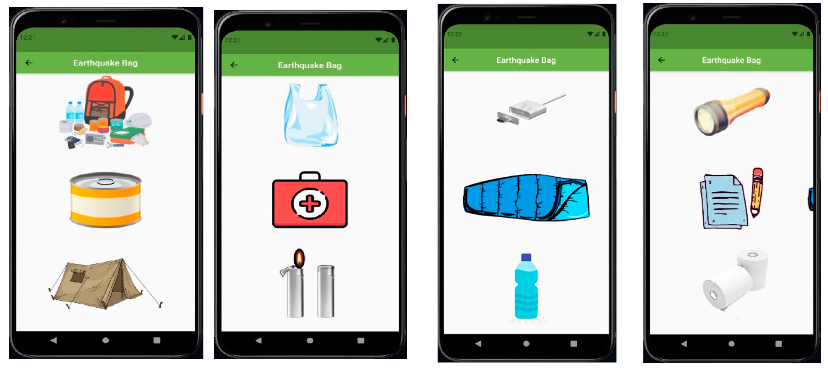
4.3. “Earthquake Bag” Page
The “Earthquake Bag” page is presented in
Figure 7. It provides information about the items that should be owned by people during emergency situations. Basically, as an emergency situation, an earthquake is considered in the application.
The page, which shows the necessary items for the earthquake bag, is formed in the application. Pictures and information of needed items that should be provided before the earthquake are displayed on the page with the NetworkImage structure, using three RowSlider screens.
4.4. “Emergency Sound” Page
With the “Emergency Sound” page, a sound system is presented in the application. The presented sound system allows users to notify other people about their location when they are under debris. In this way, users will be able to announce their location during or after an earthquake with a sound. Additionally, this property will enable them to be found under debris much faster. The purpose of the application is not only providing information. Besides this, the main aim is providing features that can be used during and after an earthquake.
A SoundPage page is created with widgets as given in
Figure 8. Widgets allow us to obtain sound using SetState. Emergency sound is added to the DepApp project for users to notify people outside of their location during an earthquake. Utilizing necessary libraries, four different audio data are used. In the application, the sound property starts to work as soon as the button is touched, then the image on the page changes. In this way, it also checks whether the system is working or not.
4.5. “I Felt the Earthquake” Page
With the “I Felt the Earthquake” page, a questionnaire system was created for users to answer after an earthquake. The questionnaire is about how and to what extent the users felt the earthquake. According to the results of the questionnaire, useful instructions are given to the users. Additionally, some addresses that can be helpful during emergency situations are given to the users. They can contact these presented addresses to reach help after the questionnaire. Feedback is provided to users according to the rate of shaking which was felt by the users during the earthquake. Thus, in the application, an opportunity is given to users to indicate how they felt the earthquake and how the magnitude of the earthquake had an effect on them. In addition, this is a chance for users to present their opinions about the earthquake.
On the “I Felt the Earthquake” page, some questions are asked to the users after the earthquake to define the felt intensity of the earthquake and to transfer the collected data to the necessary units. A grading of the earthquake intensity is created according to the answers obtained from the users.
4.6. ” I Felt the Earthquake Questionnaire” Page
With the “I Felt the Earthquake” page, as shown in
Figure 9 and
Figure 10, an application page was created. It takes the users’ opinions about the earthquake after the earthquake. The application informs users about what they should do after the earthquake. Additionally, it enables them to see emergency numbers when the survey is over.
The intensity of the felt earthquake is graded with survey questions on the “I Felt the Earthquake” page. There is a score for each answer. According to the total score, four levels are presented in the application. Additionally, each one of these four levels is explained with the first eight levels of the modified Mercalli intensity scale [
26,
27,
28]. If the total score of results is less than eight, then the considered level is level-1 which is equal to the modified Mercalli intensity scale level of 1-2 or 3. In the modified Mercalli intensity scale, level 1 is “not felt”, level 2 is “weak”, and level 3 is “weak”. If the total score of results is greater than 8 and less than 12, then it is level-2 which is equal to the modified Mercalli intensity scale level of 4 or level of 5. In the modified Mercalli intensity scale, level 4 is “light” and level 5 is “moderate”. If it is greater than 12 and less than 16, then it is level-3 which is equal to the modified Mercalli intensity scale level of 6 or level of 7. In the modified Mercalli intensity scale, level 6 is “strong” and level 7 is “very strong”. A total score greater than 16 is indicated as level-4 which is equal to the modified Mercalli intensity scale level of 7 or level of 8. In the modified Mercalli intensity scale, level 7 is “very strong” and level 8 is “severe”.
For the felt earthquake, the necessary instructions are shown on the results page as given in
Figure 11. The necessary instructions are formed according to the determined levels of the modified Mercalli intensity scale.
4.7. “Questionnaire Results” Page
According to the results of the questionnaire, if the considered level is between level 1 and level 5 of the modified Mercalli intensity scale as given in
Figure 11, then directives are given to the users according to their situation.
According to the survey results, if the considered level is between level 6 and level 8 of the modified Mercalli intensity scale as given in
Figure 12, then directives are given to the users according to their situation.
4.8. “Safe Area” Page
With the “Safe Area” page, the locations where users should go to for their safety after an earthquake are given, as represented in
Figure 13. The location of the safe areas is shown to the users on the map, along with route information. In addition, detailed information about safe areas is given. In other studies, there are few applications involving this subject. However, showing safe areas on a map is important for every city. In recent years, especially after earthquakes in big and crowded cities, the importance of safe areas has been understood intensely.
A page is created with stating the locations and names of the closest and most suitable safe areas to go in the event of an earthquake. With the markers in Google Maps, it is ensured that the safe areas are indicated. The created markers are converted into dart language with json structure. With the AnimatedBuilder widget on the map, pictures and location displays of safe areas are provided.
The name, address, and location of the secure areas and an image of that location are created with the json data.
4.9. In-App Notification (Push Notification)
In the application, earthquakes which occurred near the user’s current location are displayed to the user with notifications, as shown in
Figure 14. It is provided to inform the user within the menu and with the application in the background.
4.10. “DashBoard” Page
With the Earthquake Emergency Numbers Page, contact addresses were added to the application to receive information or to report emergency situations during or after the earthquake, as given in
Figure 15. In this way, it is provided to increase the importance of communication with the application and to develop a beneficial project for people. An emergency call menu is formed in order to create a quick call after the earthquake with the emergency numbers button to be used where communication is restricted.
On the Dashboard page, contact information, phone numbers, and e-mail addresses are added to be used for an emergency. In addition, contact addresses that users can contact in an emergency are added.
5. Comparison with Related Works
With the mobile application, information about earthquakes was gained from the Colombian Geological System. It presented the location of hospitals. The application was formed with the Android operating system [
29]. The presented application in [
29] has less functions when compared to DepApp. The extra functions that are presented by DepApp include the earthquake bag, emergency sounds, and a questionnaire. The items that might be needed after a severe earthquake are presented in the earthquake bag functionality. The emergency sounds take place in the app. A questionnaire is presented to collect information about the intensity of the felt earthquake. Additionally, the information about earthquakes is gained from [
25] in DepApp. Instead of hospitals, the locations of safe areas are presented in the DepApp application, because most people already know the locations of the nearest hospitals around them. However, they do not know the latest locations of safe areas to gather. Furthermore, the utilized technology is similar in both of the applications.
The applications, NINA, Katwarn, and FEMA were compared in the study. In NINA, warnings were displayed in a list but Katwarn uses a map. NINA and FEMA offered emergency tips, unlike Katwarn. Only FEMA presented Meeting Places and safe areas [
30,
31]. In DepApp, warnings are displayed both in a list and on a map. As emergency tips, earthquake bag preparation tips are given in the app. Meeting Places and safe areas are presented for users. Additionally, in DepApp, a questionnaire system is created for users. They answer this questionnaire after the earthquake. Thus, recommendations are given to users according to their answers. Additionally, the given recommendations will be private, not general.
The study assessed the public’s information needs and app feature preferences. It focused on multi-hazard apps. The following were defined as relevant information: time, location, hazard severity, behavioral recommendations, and the contact details of emergency services. The following features were also considered in the study: a help button, push notifications, a sharing function, a “Report an event” button, an “I am safe” button, and a chat forum [
32]. When compared to [
32], DepApp has all of the relevant information and most of the features considered in [
32]. However, DepApp is a single hazard application.
The study examined some of the applications that were used in critical situations. In all the applications, end-users demand access to the contact details of emergency services, and demand to have the chance to give feedback [
33]. In DepApp, the contact details are accessed and feedback of end-users is collected by the presented questionnaire system.
The study presented a review of the available mobile applications and interviews with focus on flood disasters. In the study, it is stated that during and after a major disaster event, people need information about medical health (e.g., hospital lists), temporary shelters, a live ticker (e.g., a map with the affected area), damages (e.g., severity of the disaster, number of deaths), and food supplies [
34]. In DepApp, the nearest safe areas are shown on the map. As a future work, giving information about hospital lists, temporary shelters, a live ticker (e.g., map with the affected area), damages (e.g., severity of the disaster, number of deaths), and food supplies will be useful.
The study examined citizens’ attitudes towards social media in emergencies. According to the collected results, people mostly want to have a map on which the hazards are shown with icons presenting the severity of the hazard [
35,
36]. In DepApp, the list of last earthquakes are presented, and they are shown on a map.
The study explained that the information needs of agencies and the public evolved throughout the sequence depending on the impacts experienced by people [
37]. Thus, a great range of required information is provided in DepApp. In DepApp, a list of the latest earthquakes, general information about earthquakes, locations of safe areas, and information for the preparation of an earthquake bag are given.
People demand to receive push notifications including the following information: guidance, hazard type, location, time, and source [
38]. In DepApp, guidance, hazard type, location, time, and source information, including push notifications, are given.
It is accepted that utilizing existing interfaces that are familiar to users and using meaningful visualizations (e.g., images, maps) in applications is a better choice for disaster applications [
39]. In DepApp, a user friendly interface is designed with a meaningful visualization by using images and maps.
6. Conclusions
Earthquakes cause both loss of life and property. We need to accept earthquakes as a part of our lives. We do not have any prior information about these disasters yet. It is very important to benefit from technology and information systems in a region where we have to live with this reality.
An earthquake information system application was prepared by Kandilli Observatory. Information about recent earthquakes is given in the application [
25]. In addition, detailed information about earthquakes is also given in the application. The study allows us to see the time and intensity of the earthquake with instant feedback. Thus, information about the latest earthquakes is obtained by using the Kandilli Observatory data in DepApp. With the created list method, the intensity, time, and location of earthquakes are placed. The location of the earthquake is shown on Google Maps. The Recent Earthquakes page in the application allows users to see the latest earthquakes and obtain information about earthquakes.
In [
1], an application for user participation was created. The presented crowdsourcing method is also utilized in DepApp. In the project, there was a notification system that was created by volunteers. It was ensured that volunteer participants played an active role in the application. In the DepApp project, a survey form is designed for user participation. With the survey, “I Felt the Earthquake”, the felt intensity of an earthquake can be determined. According to the questions, the choices of an answer are adjusted according to the earthquake intensity. Necessary instructions are presented as a result of an earthquake that was felt less. If the result of the survey determines that the earthquake was felt too much, this situation is reported to the necessary units.
The idea of safe area in [
40] is also considered and worked on in DepApp. The page of safe areas shows safe locations to go during and after an earthquake in DepApp. With this page in the application, it is provided to show users safe areas where they can be protected and take shelter in case of an earthquake.
In [
2], an earthquake bag was considered and worked on. On the earthquake bag page in DepApp, items that should be found in an earthquake bag are shown.
With the DepApp application, it was desired to develop a more beneficial application for people by using technology to reduce the problems caused by earthquakes. In the presented application, there is a diverse application structure that can be accessed by every person over a mobile platform. With the DepApp, it is aimed to minimize the damages of earthquakes that take place in our lives. As a future work, the text shown in the screen can be read aloud by screen readers for blind users.
