1. Introduction
Catastrophic tanker accidents resulting in marine pollution have dramatically reduced in recent decades by about 90% from their levels in the 1970s [
1]. However, oil trade by sea and tanker tonnage continued to increase as the oil carried by sea has multiplied by a factor of two between 1971, before the oil shock of 1973, and 2021 [
2]. Following demand developments, the deadweight tonnage of the world tanker fleet followed a similar course with no immediate prospect of the trend reversing [
2]. More recently, geopolitical factors, ranging from trade sanctions to full military conflicts, have resulted in the reshuffling of oil tanker trade routes, leading to extensive use of transhipment practices, thus compounding the risk of marine pollution through operational mishaps. Such exogenous disturbances to optimal routing and operations refocus the interest on vessel incidents with oil spill potential and on factors that may lead them to develop into full accidents with disastrous consequences. In parallel, the increase in the number and in the average tonnage of all types of ships since the start of the century [
2] increases the risk of pollution through fuel leakage in case of accidents.
The present research constitutes an innovative approach to address proper public information on marine incidents as these develop into accidents or not, responding to the call for a holistic approach by researchers [
3] of marine pollution. Unlike the case of the more familiar marine litter [
4], there has traditionally been a lack of familiarisation and public awareness of causes and responses to shipping incidents. Pressures from uninformed populations have led authorities to respond through inefficient modes of action; a characteristic case was the
Prestige tanker accident [
5] where the course of action taken under public pressure resulted ultimately to the destruction or severe damage of the resources the action chosen for impact aversion—i.e., sending into the ocean a heavily damaged vessel—was supposed to protect. Although the creation of a novel platform such as E-S.A.V.E cannot automatically avert the occurrence of a vessel-related incident, its dissemination and use by the public may well assist in preventing such an incident from turning into a full marine pollution accident; this can be achieved by mitigating spontaneous public reactions that are due to lack of information.
The innovative E-S.A.V.E concept is also aligned with the recent interest of researchers and policymakers using IT applications including software tools in the area of marine pollution [
6].
With a view to limiting public misinformation in an innovative but also educating way, the paper advances the E-S.A.V.E online platform, which is part of the risk management research project AEGIS+, funded by Greece and the European Union. The platform has been designed as a suitable support to the responsible and accessible information of the general public in case of marine incidents or accidents with marine pollution potential. The E-S.A.V.E platform (a) meets the needs of different users as confirmed by a survey that was run across multiple groups, (b) uses an appropriate Web-based Geographic Information System (webGIS) environment optimised for this purpose, (c) cooperates with public authorities, for reliable information and updates of automated incident-monitoring systems, and (d) employs an artificial intelligence (AI)-enhanced tool for social media monitoring.
It is expected that the E-S.A.V.E platform, providing access to educational and information resources on marine environmental protection and sustainable maritime logistics at both the national and international levels, can minimise the misinformation of the public. In this way, some maritime transport risks may be reduced as well, allowing for the application of optimal solutions for containing maritime pollution following an accident with the consent and tacit cooperation of affected populations.
The structure of the main body of the paper is the following:
Section 2 includes a general overview of the impact of major oil tanker spills on the development of environmental regulation and reviews the literature on the innovative approaches to marine pollution and especially on the role of information in population reactions during the management of marine accidents.
Section 3 presents the survey design for assessing user needs in relation to the information platform Electronic Shore Awareness of Vessel Emergencies (E-S.A.V.E). In
Section 4, the authors showcase the steps for constructing this original platform for mitigating misinformation the public receives regarding shipping traffic incidents in coastal/island areas.
2. Materials and Methods: Literature Review of the Potential of E-S.A.V.E
2.1. Oil Spill Marine Accidents and Impact on Regulation
In general, while the long-term impact of regulatory and operational developments has yielded spectacular results on the number and total impact of marine pollution incidents in the past years, as shown in
Figure 1, the probability of a catastrophic accident has not been zeroed.
As the literature underlines, there is a stochastic element in the evolution of exogenous unpredictable factors [
8,
9,
10], especially the ones falling in the “Black Swan” category [
9]. Such factors have the potential to impact stochastically on the creation of oil spills.
In the case of tanker accidents, research had pointed earlier also to the need for preparedness by educating populations at risk to facilitate optimal management of tanker accidents as these evolve [
11]. Accidents involving other types of oil-fuelled vessels warrant appropriate information, and leaking marine bunkers also result in oil spills as underlined recently by accidents involving containerships [
12].
Also, as pointed out by the authors of [
11], the residual effects of shipping accidents, especially those that involve tankers, linger for a long time. Such an impact damages regional economies, tarnishing the reputation of produce and local resources in general.
Oil spills from drilling have also attracted public interest with notable examples including the oil spill following the 2010 rig accident in the Gulf of Mexico and the Deepwater Horizon spill, which is considered one of the two major oil pollution accidents to affect US waters [
13]. However, as
Table 1 below shows, most major regulatory changes at the international (or regional) level have been historically a direct or indirect result of vessel accidents.
Among the accidents included in
Table 1, the sinking of the tanker
Prestige in 2002 accelerated further the application of stricter new regulations in the EU. This accident also highlighted the role of communicating the appropriate information to the public so that the reactions of as well as the pressures on authorities by the affected local communities do not impede the optimum management of shipping incidents, which may have marine pollution potential [
11].
2.2. Oil Pollution Misinformation Potential and the Role of Information Networks
The role of misinformation in incident and accident mismanagement has been well documented and, as pointed out in [
9], the management of the
Prestige incident from its start to its end as a major environmental disaster corresponds to all human factors involved in maritime transportation accidents in the way such factors are quoted in the literature [
16]: misinformation about site conditions, lack of awareness, lack of teamwork, and wrong judgments under pressure. These events due to human factors have been quantified and determined as misinformation about the conditions of the site, lack of awareness, lack of teamwork, and wrong judgments under pressure.
Engagement of the general public is one of the aims sought to be achieved through the Ε-S.A.V.E, turning its users from uncoordinated passive receivers of information that they may distrust to eventually even active contributors as has been observed in post-accident population involvement in clean-up operations [
17].
As a vessel incident with marine pollution potential unfolds, distrust in official sources or placement of trust in media coverage geared towards the sensational instead of the scientifically accurate is not rare; this is either on purpose, for attracting audiences, or through lack of appropriate resources, leading to a distorted perception of the appropriate course among the range of alternative options. Such distortion can easily be created through these factors alone and can be easily compounded further by the lack of information that the general public is bound to have.
Thanopoulou et al. [
11], in their original approach to creating a remedy to this problem, suggested that appropriate information dissemination can address both the issues of distrust in public information and counter media sensationalism. At the start of the 2010s, the S.A.V.E network concept was deployed in order to educate coastal populations to react in an informed way during vessel incidents based on ad hoc trained members of coastal and island communities sourced from the sea-related tourist professions to serve as a trusted education and information source in their local communities.
The general idea of such a network was presented to the local media [
18] in the summer of 2011 at the Maria Tsakos Foundation - International Centre for Maritime Research and Tradition, followed by a survey to test the level of appeal and applicability of that initial concept in an island or coastal community. However, the analysis of the survey results at the time [
11] in combination with the observed negative public reactions during the
Prestige 2002 accident [
5] showed the need for a more comprehensive direct approach putting the emphasis on countering the potential media impact on the basis of the familiarisation of the public with electronic platforms, including those for accessing information on risk-creating events.
2.3. Population Reaction to Marine Pollution: Literature Review
Public awareness in terms of marine pollution is considered a positive factor overall, especially in terms of the Power of Consumer [
19]. In the case of the
Prestige accident, the chain of events that ultimately led to the failure to contain the oil spill outside the Galician coast before the sinking of the vessel highlights the importance of misinformation during developing incidents. As discussed in [
11] on the basis of [
5], public reactions led decision-makers to exclude a containable transhipment of the vessel’s cargo under strict conditions, which would eventually minimise the impact on the environment. Instead, under public pressure, administration decisions led to a—as it transpires from the description of the vessel routing [
20]—haphazardly ordered the course of the damaged vessel to the open seas, which ended with the early sinking of the ship.
2.4. Calibrating the E-S.A.V.E Platform’s Targeted Use: Initial Platform Design
The E-S.A.V.E platform has been designed and constructed by the authors as a solution to public misinformation during marine pollution incidents involving vessels. The general concept was to use AIS data provided by one of the three original—industry or benevolent foundations—volunteer supporters of the E-S.A.V.E/AEGIS+ project; it also includes visualised webGIS data for real-time or near real-time monitoring of incidents with a marine pollution potential across the Greek seas. It was originally designed to interact with social media networks and to offer web links and directions for finding information material on marine environmental protection issues (
Figure 2).
2.5. Methodology for Building the E-S.A.V.E Platform
The authors aimed at constructing an electronic platform, which would be easily recognisable, informative, and potentially expandable, with the capability to integrate with related platforms in the area of marine pollution. During the design phase, attributes of reliable electronic information in the form of portals, platforms etc., which define usefulness and usability, were considered. Such attributes included ease of use and navigation, terminology, and learnability, as suggested by the literature [
21]. The basis for incident mapping and the data and software to be used were the other important choices that had to be made.
Web-based Geographic Information Systems (webGIS) are the most common basis for mapping marine environment features, especially for pollution monitoring. They have been used also for the development of forecasts of oil spills and for information on marine pollution in general [
22].
WebGIS applications are designed to be applied to specific case studies with a specific database. A typical webGIS application consists of a server that hosts the web services, a GIS Server for geospatial data and related web services (1. WMS—Web Map Services, 2. WFS—Web Feature Service, 3. WCS—Web Coverage Service, 4. WMTS—Web Map Tile Services, 5. WPS—Web Processing Services, 6. WCPS—Web Coverage Processing Service), and a client, which can be any web browser [
23,
24]. The use of webGIS technology has enhanced the free use of GISs by contributing to (a) the easy access and dissemination of spatial data, (b) the visualization and navigation of spatial data, and (c) the processing, analysis, and modelling of spatial data [
25].
WebGIS applications have several advantages over standard GISs, but also some limitations; their major advantage is that they incorporate all the benefits of the internet, such as mass access to highly accurate geospatial information, which is available worldwide simultaneously due to internet access. Unlike standard GISs, where the geodatabase resides in a single location, a webGIS allows data to be accessed by anyone with an internet connection. Furthermore, this access is free for end-users, while the purchasing of the relevant software for standard GISs can be quite expensive. Additionally, webGIS applications typically have a user-friendly interface, incorporating limited tools and functions that are relevant to their intended application. This can be seen as an advantage compared to standard GISs, as non-specialised users can become familiar with them more quickly than with complex desktop GISs [
26].
However, webGIS applications also have some disadvantages. The speed of data transfer and processing can be slower compared to standard GISs, depending on internet connectivity [
27]. Overall, although webGIS applications cannot completely replace conventional systems, their advantages outweigh their limitations. Nevertheless, when there is a need for a large number of users to access a spatial database, the use of webGIS applications becomes inevitable.
2.6. Software Selection for Constructing the E-S.A.V.E Platform
The development of the webGIS application for E-S.A.V.E is designed using ESRI’s software, more specifically the ArcGIS 10.8.1 Desktop for managing, storing, and analysing spatial data and ArcGIS Enterprise [
28] for hosting the GIS Server that provides the web services. The web application provides a user-friendly environment with a simple architecture consisting of the following components:
The spatial database, which includes (i) online maps, which are services (map services) published on the GIS Server to be available online, and (ii) base maps provided by the ESRI library.
Auxiliary tools, which are spatial analysis tools (e.g., measurement tools) or data manipulation tools (e.g., “print a map”, save attributes etc.), are available from the ESRI library. These tools facilitate data visualisation and presentation.
Navigation tools that assist in exploring the study area.
2.7. Use Cases: Survey Methodology, ID, and Questionnaire Distribution
A questionnaire-based survey was used for defining use cases, providing respondents with a range of types of information to choose from, allowing also open-ended contributions of additional types of information that respondents would find useful when using the platform to monitor the development of a shipping incident with marine pollution potential.
The survey ran between August 2022 and March 2023. While the survey period was long, no extreme shipping incidents involving oil tankers or other marine pollution were registered during that period, which could have influenced the perception of part of the respondents.
Data collection took place in Greece, a world shipping leader in terms of the cargo-carrying capacity of the Greek-owned fleet. Greece is also a major tourism destination with the most significant island and coastal population dispersion and a major maritime traffic corridor. Questionnaires in the Greek language were distributed electronically as a link for either electronic completion through a Google form or for completion in a printed version; in both cases, they were completed anonymously. Survey distribution channels used were related to shipping and marine pollution: a key one was the dissemination of the survey link through the Newsletter of one of the project’s original supporters, HELMEPA (Hellenic Marine Environment Protection Association), which is delivered electronically to thousands of email addresses. In addition, the distribution of the printed survey questionnaire took place during conferences relevant to shipping and during seminars/lectures of the University of the Aegean.
The effort yielded 128 completed and usable questionnaires out of an initial number of 129 (68 electronically completed and 60 through hard copies). While the sample size allows inferences with a degree of certainty, the sample composition falls rather into the category of convenience sampling [
29] whereby inferences should be considered tentative. However, the process has been considered fitting the exploratory stage for the creation of an innovative platform considering the prospect of E-S.A.V.E being further developed in the future whereby expansion should be based on a more stratified survey by potential user categories.
Responses to the demographic questions at the end of the survey questionnaire (cf.
Appendix A) revealed that 60% of the respondents had a relationship of work or study with the shipping sector, while two-thirds of this group had also at least one family member—or more—related in some form to the shipping sector. The remaining 40% of total respondents had no connection, professional or family-wise, with shipping.
As the survey targeted a mix of potential respondents, the questions were formulated in simple terms as, to a large extent, the questionnaire was to be replied to electronically with no supervision. Questions (Qs) were thus calibrated towards average education levels and minimum degree of familiarisation with marine operation/pollution-related incidents.
3. Results
3.1. Validating Platform Design through Survey Feedback
All survey results were considered valuable input by the authors. However, the opinions and suggestions of 40% of respondents who were not connected to shipping were considered even more valuable as falling into the general target group of platforms such as E-S.A.V.E; this was especially so for the open-ended question included in the survey.
Descriptive statistics for the first two questions on value and alternative use of the E-S.A.V.E platform, i.e., Q
1 “How much do you think that running a website similar to the one described above would be of use to you?” and Q
2 “Do you think you would use this platform in preference to usual Media?” are presented in
Figure 3.
Figure 3 shows the mean, median, standard error, variance, and sample mode values of the provided answers for Q
1 and Q
2. The Likert scale provided a range from 1 to 5, corresponding in linguistic terms from “No use at all” to “Very much” or “Exclusive use”, respectively, as shown in detail in
Appendix A. Statistics on questions related to the preferred features and demographic questions are not included in
Figure 3 as having multiple choice or binary answers.
Answers given for Q
1 averaged 4.33, showing the perceived high value of developing a research-based website platform with information related to marine accidents and oil spills; moreover, the central tendency of the answers was at the greatest value range as shown in
Figure 4 below.
Q
2 (
Figure 5 below) required evaluating the use of a platform like E-S.A.V.E in preference to usual media (
Appendix A) on the basis of a five-point Likert scale.
The mean value for responses to the question is 3.68, which is less than the value of 4, corresponding to “Frequent use”, so the expectation is that the platform will be used more than usual media. In addition, as 42% of participants anticipate frequent use of the platform, overall frequent and exclusive use add to 60% of respondents finding the E-S.A.V.E proposition more attractive or of exclusive attraction as a source of information.
Furthermore, answers to the open question (Q3), to which users were invited to complete suggestions for site enrichment, could be classified into six groups:
As much information about the incident as possible: Related suggestions, recorded through the open question, included the map area of the incident, weather conditions, local authorities contact information, P&I clubs and classification societies, contact information of tugs, salvage, antipollution and offshore support vessels, medical instructions, type of incident, local weather, protected areas, and nearest volunteer teams.
Audio-visual material (either informative from similar situations historically, or real-time during the progress of the incident).
Continuous update of the site with free access without advertisements and the creation of a newsletter.
Findings of recent (involved) vessel inspections.
Incident outcomes and stakeholder impacts (qualitative and quantitative).
Information about responsibility for the incident.
In terms of frequency, as shown in
Figure 6, the most frequent types of information that users think must be provided through the platform and the webpage are the following:
Vessel(s) details for the ones involved in the incident
Vessels’ oil cargo information
Links for national and international bodies, which monitor marine pollution incidents
Links for marine environmental protection organisations
AIS (Automatic Identification System) Data
3.2. Survey Limitations
In relation to the 2023 survey data, one reservation is that the participation of the “general public” category in the responses may not be robustly measured due to the number of electronic responses: unsupervised respondents could ultimately be related to shipping, even if they did not so declare due to the survey dissemination channels, which to a large extent were related to maritime research or shipping related courses at various levels. However, with the platform being a pilot project, the target of crowdsourcing additional ideas on use cases from the general public and from people involved in shipping was achieved to a satisfactory extent through the overall large number of answers and suggestions received.
3.3. The Content of the E-S.A.V.E Platform
The web interface of E-S.A.V.E has been designed to provide spatial information about both marine incidents and data related to the marine environment through screens similar to
Figure 7 below, where the yellow triangle signals a declared incident and the red one an accident with ascertained marine pollution; the distinction and verification remains with the authorities through the Greek Ministry of Merchant Marine.
The available marine environmental data are divided into the following main groups:
Geographical demarcation of ecological features and habitats, such as seagrass meadows, coastal lagoons, coralliferous aggregations, wetlands, marine caves, important bird areas and habitats of cetaceans, monk seals, and turtles.
Mapping of human activities and infrastructure, including ports, fish farming, recreational, and touristic areas (scuba diving locations, bathing waters, etc.).
Designated marine management and protected areas, such as Natura 2000 areas, fisheries restricted areas, Ramsar sites, marine protected areas of National statute (MPAs), and Ecologically or Biologically Significant Marine Areas (EBSMAs).
Attributes of coastal beach areas, such as their socio-economic characteristics (e.g., accessibility, the existence of coastal roads, visitation etc.) and their natural characteristics, such as sediment type, hydrodynamic forcing, beach-retreat projections, etc.
3.4. Overall Architecture of the E-S.A.V.E Platform
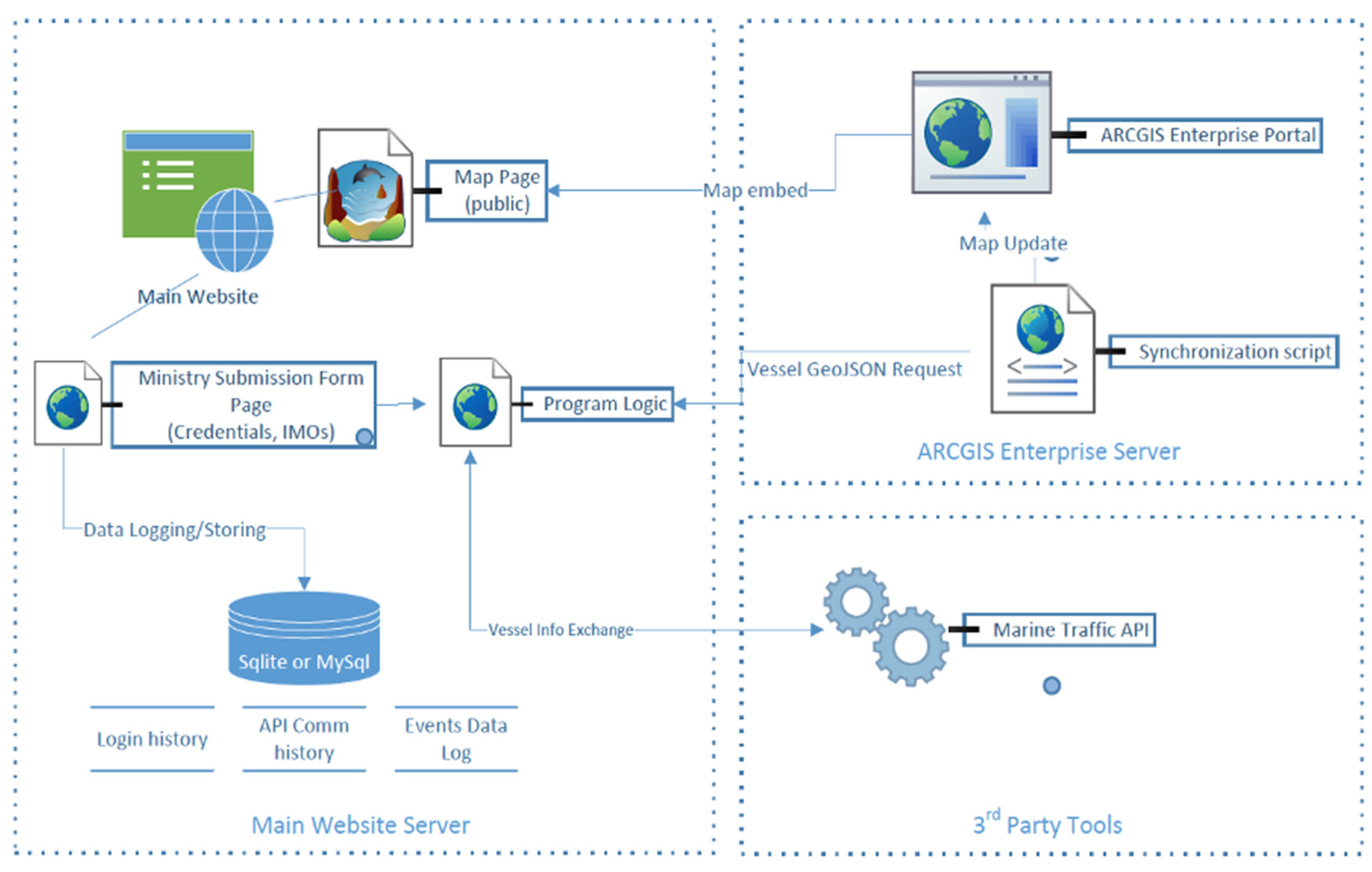
The entities involved in the E-SAVE platform architecture and their communication are shown in
Figure 8 below.
The system logic is separated into three major groups: (a) the main server, (b) the third-party APIs, and (c) the Geospatial server.
The main server hosts the web portal that is accessed by the public in order to be informed about any occurring incident. It also hosts a private page where the authorities through the relevant ministry submit an incident inserting the International Maritime Organization (IMO) number of—at least—one vessel involved in order to trigger the information system mechanism.
The backend mechanism firstly checks on the submitter authentication. If the submitter is certified, the log entry of the submitter is written in the login database table and the communication with the MarineTraffic API [
30] is triggered. To initiate the communication, an authentication token is generated and is used to begin the communication loop. In turn, the communication loop consists of two steps with each one targeting a different API endpoint.
The technology described is based on REST APIs, PHP, SQLite, and Python and has been developed following a Rapid Application Development (RAD) approach as examples in [
32] with an emphasis on simplicity and stability.
3.5. Feedback from Public Reactions: E-S.A.V.E as Update—Comment Website from the Platform Social Media Account
An innovative application has been designed to harness the power of Twitter, which leverages natural language processing techniques to retrieve and analyse comments associated with potential incidents/accidents. Our aim is to provide the admin(s) with a robust search algorithm that enables real-time information gathering from Twitter. By extracting valuable insights, our app facilitates a timely response and informed decision-making. The Specification Report thoroughly outlines the technical requirements, key functionalities, and design considerations essential for the seamless development and integration of both the website and the Python application.
As part of the task, the objective was to design and implement an application that assists administrators by providing user reactions in the event of an incident. The developed system focuses on extracting pertinent knowledge from user comments on the social network Twitter related to specific events such as pollution, oil spills, ecological disasters, shipwrecks, sinkings, and more. By leveraging this information, administrators can gain valuable insights to effectively respond to and address the incident.
In the implementation of the application, we have incorporated Machine Learning techniques to enable automated evaluation of key comments, providing administrators with accurate and valuable information. By leveraging Machine Learning, the application can effectively analyse and classify the most relevant comments, ensuring that administrators receive valid insights to make informed decisions.
The application serves a multi-faceted purpose, offering more than just early incident detection and identification of affected communities. It plays a crucial role in directing marine pollution containment efforts, fostering effective communication between stakeholders, and raising environmental awareness. By disseminating information to the public and signalling their main concerns, the application empowers individuals who seek to stay informed and actively engage in combating marine environmental disasters. It enables both individuals and organisations to take immediate and well-informed action, effectively contributing to impact mitigation through trusted channels of feedback communication between stakeholder categories. Upon completion of the execution, administrators are provided with the capability to collect the data and perform cross-referencing of false and malicious comments. This functionality enables them to identify misleading or harmful content and take appropriate actions, such as imposing sanctions, if necessary. This ensures the integrity and reliability of the information gathered, fostering a safer and more trustworthy environment within the application.
The designed application scans user comments in both Greek and English, searching for specific keywords. The list in
Table 2, below, outlines these keywords in both languages.
The tool-highlighted keywords will be renewed at short intervals, thus providing feedback on the objective and subjective impact of the incident and its consequences on the populations affected.
4. Discussion
On the basis of the analysis of the findings, the concept and the construction of the E-S.A.V.E platform are expected to contribute in multiple ways to improving the management of vessel incidents/accidents with marine pollution potential. This contribution is revealed to be multifaceted, having a number of advantages, as suggested also by the analysis of the responses:
The results from the survey, seeking to gauge the fullest range of use cases, are encouraging since a significant majority finds the platform under development of high or very high value, as transpires from the mean rating of answers to key survey questions for the value and the role of the platform vis-a-vis traditional media. Design specifications have been validated and further enriched through specific user suggestions, increasing the potential benefit from the construction of the E-S.A.V.E platform.
The availability of such a platform seems to be deemed to play a significant role in combatting public misinformation—which has proved to be a significant risk in the management of marine pollution accidents originating from vessel traffic—and to facilitate the optimal management of shipping incidents/accidents with marine pollution potential.
The construction of the platform showcases the advantages of open software for the creation of user-friendly electronic platforms, providing not only information but also access to free educational resources, as well as for empowering the public and increasing environmental awareness but also familiarisation with the operations of the backbone of maritime logistics, i.e., the international shipping industry.
E-S.A.V.E presents benefits for all types of audiences interested in or affected by shipping incidents, ranging from students of maritime education and training at all levels from seafarers, shipping and port executives, and public authorities to consultancy and research communities. It is also the result of the close cooperation of a range of stakeholders including government agencies, non-governmental organisations, industry, and research. In this respect, it fits with current research on stakeholder cooperation for addressing externalities such as marine pollution.
5. Conclusions
Information on incident-involved vessels from public authorities (the Hellenic Coast Guard) through vessel traffic AIS data (MarineTraffic) as well as data on sensitive environmental regions and coastal infrastructures provided by national research infrastructures created by academia have been combined and presented by the authors in a Geographic Information System enabling the fast overview of the developing situation and of related threats to coastal resources. This information is freely and universally disseminated to interested parties and to any potential user of the platform.
This innovative electronic service has been given the symbolic name of E-S.A.V.E (Electronic Shore Awareness of Vessel Emergencies), as it has been designed to inform the public ashore on developing marine pollution incidents using open software, including access to web resources for trustworthy information, while providing marine environmental education resources and encouraging user feedback, thus promoting overall sustainable maritime logistics. Transmitting independent, trusted, and responsibly provided information, the platform is expected to play a positive role in mitigating pressures on decision-makers by parts of an ill-informed public when the former are selecting optimal paths for averting or containing marine pollution while vessel incidents are in progress.
In terms of the further improvement of E-S.A.V.E, results from further user surveys—beyond the one annexed in this paper as
Appendix A—will be analysed; these will include the input of users during the first year of the platform’s operations following the analysis of validation data at the end of the project. A voluntary questionnaire for the anonymous collection of user profile data will be also linked to the main page, opening a shared Microsoft Excel menu even though such data can be considered as indicative due to a lack of control of repetitive submissions. An email,
esave@aegean.gr, will allow further user feedback, while such feedback will be made feasible also through the platform’s—already created—social media. Usage data collection through the webpage will also be encouraged via the E-S.A.V.E site, through an open data policy applying all personal data protection provisions to users and contributors.
Finally, this innovative attempt to responsibly inform the public about maritime incidents with marine pollution potential is considered valuable as a blueprint for the construction of further tools or platforms, which can lead to an efficient and safe engagement of the public in actions of prevention or limitation of eventual marine pollution; E-S.A.V.E was successfully built on the basis of stakeholder cooperation, including public authorities and academia, in a context of synergistic action via a step-by-step approach in defining roles and responsibilities.
Author Contributions
Conceptualization, H.T., G.G. and A.P.; Methodology, H.T., O.M., A.P., V.Z., A.K. and O.P.; Software, A.K., O.P. and O.M.; Validation, V.Z. and I.D.; Formal Analysis, V.L. and H.T.; Investigation, H.T. and G.G.; Data Curation, V.L.; Writing—all authors; Writing—Review and Editing, V.Z. and I.D.; Visualization, O.M., H.T., A.P., V.L. and I.D.; Supervision, V.Z. and H.T.; Funding Acquisition, V.Z. All authors have read and agreed to the published version of the manuscript.
Funding
The present article is supported by the research project “Coastal Environment Observatory and Risk Management in Island Regions AEGIS+” (MIS 5047038), implemented within the Operational Programme “Competitiveness, Entrepreneurship and Innovation” (NSRF 2014–2020), co-financed by the Hellenic Government (Ministry of Development and Investments) and the European Union (European Regional Development Fund). Layers of GIS Coastal Environmental Information, which cooperate with the E-S.A.V.E platform, have been created through the support of the EN.I.R.I.S.S.T National Research Infrastructure Project (MIS 5027930) within the Operational Programme “Competitiveness, Entrepreneurship and Innovation” (NSRF 2014–2020) co-funded by Greece and the European Union (European Regional Development Fund).
Institutional Review Board Statement
Ethical review and approval were not applicable as no sensitive/medical data/tissues were collected and no animals were involved. A related full information file with an application, in case further action was to be required, was submitted at the time of the survey to the Bioethics Committee of the University of the Aegean.
Informed Consent Statement
Not applicable.
Data Availability Statement
Acknowledgments
The authors have benefitted substantially from the comments of the referees in the journal submission process and from discussions and encouragement by the current Member of the Greek Parliament Rear Admiral (rtd) of the Hellenic Coast Guard Stavros Michailidis when Director of the supporting Maria Tsakos Foundation in Chios; thanks are owed as well to the former First Deputy Commandant of the Hellenic Coast Guard Rear Admiral (rtd) Giannis Argirakis and to the officer of the Greek Coast Guard, Commodore Giorgos Maragos (Head of Division), who both took the project under their wing as well as to Commander Georgios Kalogerakis, committed in his role as liaison officer with the research team. Thanks are due to the team of MarineTraffic honouring their support commitment of 2019 as well as to the Director General and top executives of HELMEPA, the third supporter of the research proposal, for distributing our survey link. Thanks are owed also to the team of Marathon Data for their cooperation.
Conflicts of Interest
The authors declare no conflict of interest. N.B. The corresponding author has worked pro bono for the project, in token of the commitment of the entire research team to marine environmental protection and sustainability.
Appendix A. Translated Survey Questionnaire (Original in Greek)
References
- ITOPF. Oil Tanker Spill Statistics. 2023. Available online: https://www.itopf.org/knowledge-resources/data-statistics/statistics/ (accessed on 7 July 2023).
- UNCTAD. Review of Maritime Transport. Annual. Available online: https://unctad.org/rmt2022 (accessed on 24 June 2023).
- Dahms, H.U. The grand challenges in marine pollution research. Front. Mar. Sci. 2014, 1, 9. [Google Scholar] [CrossRef]
- Hartley, B.L.; Pahl, S.; Veiga, J.; Vlachogianni, T.; Vasconcelos, L.; Maes, T.; Doyle, T.; Metcalfe, R.D.A.; Öztürk, A.A.; Di Berardo, M.; et al. Exploring public views on marine litter in Europe: Perceived causes, consequences and pathways to change. Mar. Pollut. Bull. 2018, 133, 945–955. [Google Scholar] [CrossRef] [PubMed]
- Gimémez, E. The Prestige catastrophe: Political decisions, scientific counsel, missing markets and the need for an international maritime protocol. In Documentos de Travajo en Analisis Economico; Universidade de Vigo: Vigo, Spain, 2003. [Google Scholar]
- EMSA. Feasibility Study for the Development of a Software Tool tο Support Member States on Oil Pollution Response Operations at Sea. Report EMSA. 2023. Available online: https://www.emsa.europa.eu/publications/reports.html (accessed on 1 September 2023).
- Ritchie, H.; Veronika, S.; Max, R. Oil Spills. Our World in Data. Available online: https://ourworldindata.org/oil-spills (accessed on 4 September 2023).
- Georgoulis, G.; Thanopoulou, H.; Vaneslslander, T. Routing and port choice under uncertainty: Lessons from a vacuum. In Proceedings of the ECONSHIP Conference, Chios Island, Greece, 22–24 June 2011. [Google Scholar]
- Taleb, N.N. The Black Swan: The Impact of the Highly Improbable; Random House: New York, NY, USA, 2007. [Google Scholar]
- Thanopoulou, H.; Strandenes, S.P. A theoretical framework for analysing long-term uncertainty in shipping. Case Stud. Transp. 2017, 5, 325–331. [Google Scholar] [CrossRef]
- Thanopoulou, H.; Ventikos, N.; Georgoulis, G.; Moulatzikos, L. Proactive Involvement of Local Population in Oil Spill Incidents: Gauging the Potential of Informal Information Networks. SPOUDAI 2014, 64, 50–63. [Google Scholar]
- Wan, S.; Yang, X.; Chen, X.; Qu, Z.; An, C.; Zhang, B.; Lee, K.; Bi, H. Emerging marine pollution from container ship accidents: Risk characteristics, response strategies, and regulation advancements. J. Clean. Prod. 2022, 22, 134–266. [Google Scholar] [CrossRef]
- Atlas, R.M.; Hazen, T.C. Oil Biodegradation and Bioremediation: A Tale of the Two Worst Spills in U.S. History. Environ. Sci. Technol. 2011, 45, 6709–6715. [Google Scholar] [CrossRef] [PubMed]
- IMO. List of Conventions. 2023. Available online: https://www.imo.org/en/About/Conventions/Pages/ListOfConventions.aspx (accessed on 1 July 2023).
- IMO. MARPOL. 2023. Available online: https://www.imo.org/en/About/Conventions/Pages/International-Convention-for-the-Prevention-of-Pollution-from-Ships-(MARPOL).aspx (accessed on 1 July 2023).
- Zaib, A.; Yin, J.; Khan, R.U. Determining role of human factors in maritime transportation accidents by fuzzy fault tree analysis (FFTA). J. Mar. Sci. Eng. 2022, 10, 381. [Google Scholar] [CrossRef]
- Hur, J.-Y. Disaster management from the perspective of governance: Case study of the Hebei Spirit oil spill. Disaster Prev. Manag. 2012, 21, 288–298. [Google Scholar] [CrossRef]
- Pyliotis, T. 2011. Available online: http://www.era-aegean.gr/index.php/en-katakleidi/9-2010-10-25-23-27-51/1711-2011-07-15-08-41-49 (accessed on 15 July 2011).
- Jacobs, S.; Sioen, I.; De Henauw, S.; Rosseel, Y.; Calis, T.; Tediosi, A.; Nadal, M.; Marques, A.; Verbeke, W. Marine environmental contamination: Public awareness, concern and perceived effectiveness in five European countries. Environ. Res. 2015, 143, 4–10. [Google Scholar] [CrossRef] [PubMed]
- Albaigés, J.; Morales-Nin, B.; Vilas, F. The Prestige oil spill: A scientific response. Mar. Pollut. Bull. 2006, 53, 205–207. [Google Scholar] [CrossRef] [PubMed]
- Tsakonas, G.; Papatheodorou, C. Analysing and evaluating usefulness and usability in electronic information services. J. Inf. Sci. 2006, 32, 400–419. [Google Scholar] [CrossRef]
- Kulawiak, M.; Prospathopoulos, A.; Perivoliotis, L.; Kioroglou, S.; Stepnowski, A. Interactive visualization of marine pollution monitoring and forecasting data via a Web-based GIS. Comput. Geosci. 2010, 36, 1069–1080. [Google Scholar] [CrossRef]
- Alesheikh, A.A.; Helali, H.; Behroz, H.A. Web GIS: Technologies and Its Applications. In Geospatial Theory, Processing and Application; ISPRS: Ottawa, ON, Canada, 2002; Volume 15, pp. 213–222. [Google Scholar]
- Agrawal, S.; Gupta, R.D. Web GIS and its architecture: A review. Arab. J. Geosci. 2017, 10, 518. [Google Scholar] [CrossRef]
- Dragićević, S. The potential of web-based GIS. J. Geogr. Sys. 2004, 6, 79–81. [Google Scholar] [CrossRef]
- Shaig, A. An Overview of Web Based Geographic Information Systems. In Proceedings of the 13th Annual Colloquium of the Spatial Information Research Centre, University of Otago, Dunedin, New Zealand, 2–5 December 2001. [Google Scholar]
- Peng, Z.-R. An assessment framework for the development of Internet GIS. Environ. Plann. B Plann. 1999, 26, 117–132. [Google Scholar] [CrossRef]
- Arcgis. Available online: https://developers.arcgis.com/rest/users-groups-and-items/portal.htm (accessed on 5 September 2023).
- Kitchenham, B.; Pfleeger, S. Principles of survey research: Part 5: Populations and samples. ACM SIGSOFT 2002, 27, 17–20. [Google Scholar] [CrossRef]
- MarineTraffic. Available online: https://www.marinetraffic.com/en/ais-api-services (accessed on 4 September 2023).
- SpatiaLite. Libraries. Available online: www.gaia-gis.it/fossil/libspatialite/index (accessed on 5 September 2023).
- Osgeo. Available online: https://wiki.osgeo.org/w/images/c/c7/Foss4g2009_proposed_presentations.pdf (accessed on 5 September 2023).
| Disclaimer/Publisher’s Note: The statements, opinions and data contained in all publications are solely those of the individual author(s) and contributor(s) and not of MDPI and/or the editor(s). MDPI and/or the editor(s) disclaim responsibility for any injury to people or property resulting from any ideas, methods, instructions or products referred to in the content. |
© 2023 by the authors. Licensee MDPI, Basel, Switzerland. This article is an open access article distributed under the terms and conditions of the Creative Commons Attribution (CC BY) license (https://creativecommons.org/licenses/by/4.0/).


 ,
, 


